Mount Buller and Mount Stirling Draft Municipal Fire Management Plan - Municipal Fire Management Planning Committee, 2012 - Mt Buller
←
→
Page content transcription
If your browser does not render page correctly, please read the page content below
Mount Buller and Mount Stirling Draft
 Municipal Fire Management Plan

Municipal Fire Management Planning Committee, 2012
Mount Buller and Mount Stirling Draft Municipal Fire Management Plan V2

Preface
The Mount Buller and Mount Stirling Municipal Fire Management Committee (MFMPC) is
responsible for providing a strategic and integrated approach to fire management within the Mount
Buller and Mount Stirling Alpine Resort Areas. This task forms part of a broader state and regional
framework established under the Emergency Management Act (1986) and is supported by the
State Fire Management Planning Committee and the Hume Regional Strategic Fire Management
Planning Committee (HRSFMPC).

A key responsibility of the Mount Buller and Mount Stirling MFMPC is the development of a draft
Municipal Fire Management Plan (MFMP) on behalf of the Mount Buller and Mount Stirling
Municipal Emergency Management Planning Committee for considered endorsement by the Mount
Buller and Mount Stirling Alpine Resort Management Board (RMB). This plan, which aligns with the
Hume Regional Strategic Fire Management Plan 2011-2021, describes how regional authorities,
RMBs, fire agencies and other relevant organizations can work together to effectively anticipate,
respond to and recover from bushfire events affecting Mount Buller and Mount Stirling Alpine
Resort areas.

While the management of all types of fires is important, this plan has focused on bushfire in the
first instance. The life of this plan is for three years and it is envisaged that future updates of this
plan will include planning for other types for fire. Furthermore it is important to note that this plan
recognizes, but does not duplicate, the extensive work already being undertaken in fire
management across the Resorts. This document is essentially a plan for improving integration of
this existing work and developing improved methods for working together.

I join with the members of the Mount Buller and Mount Stirling MFMPC in commending this
document to you. We see the development and implementation of this plan as important step in
the ongoing journey to securing a safer, more resilient community, healthier environment and a
prosperous economy for our Resorts.

Jonathan Chivers
Chair
Mount Buller and Mount Stirling
Municipal Fire Management Planning Committee

                                                                                               1|Page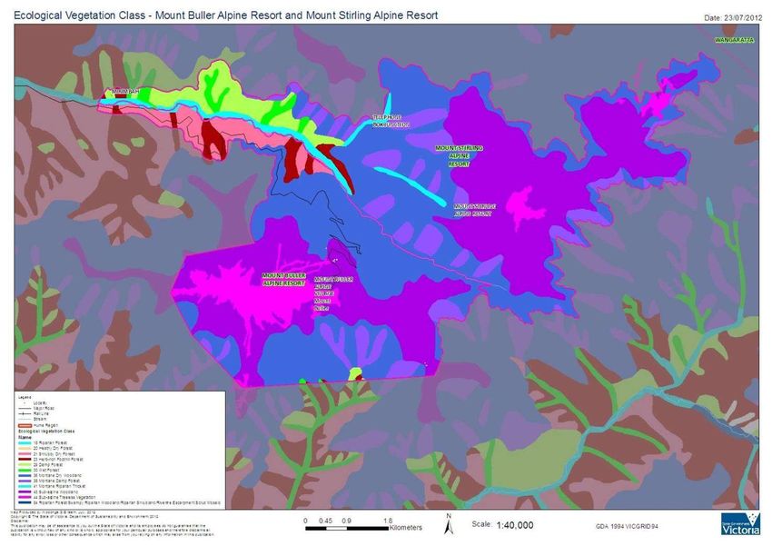
Mount Buller and Mount Stirling Draft Municipal Fire Management Plan V2

Version Control Table

 Version number        Date of issue Author(s)                  Brief description of change

 Version 1.0           4/5/12             C. Hajek and C.       Draft MFMP for Comment
                                          Price

 Version 2.0           16/7/12            C. Price, J.          New edits, edits from ARMB
                                          Chivers

Authorisation
This integrated MFMP was adopted as the first iteration of the Mount Buller and Mount Stirling
MFMP. This Plan was endorsed through a formal motion by the Mount Buller and Mount Stirling
MFMPC at their meeting on ……….. 2012, for which the Chair of the committee will sign for and
on behalf of all members of the Mount Buller and Mount Stirling MFMPC.

Signed: _________________            Date: _________________

Jonathan Chivers
Chairperson
Mount Buller and Mount Stirling Municipal Fire Management Planning Committee
Property and Development Manager
Mount Buller Mount Stirling Resort Management

This MFMP was endorsed as a sub plan to the Mount Buller and Mount Stirling Municipal
Emergency Management Plan through a formal motion by the Mount Buller and Mount Stirling
Municipal Emergency Management Planning Committee (MEMPC) at their meeting on ………….
2012, for which the Chairperson/Mountain Emergency Resource Officer (MERO) will sign for and
on behalf of the Members of the Mount Buller and Mount Stirling MEMPC

The MFMP was also adopted through a formal motion by the Mount Buller and Mount Stirling
Alpine Resort Management Board as the MFMP for the Alpine Resorts of Mount Buller and Mount
Stirling, at their meeting on ……….. 2012, for which the Chief Executive Officer will sign for and
on behalf of the Mount Buller and Mount Stirling Alpine Resort Management Board

Signed: _________________            Date: _________________

John Huber
CEO and Acting MERO
Mount Buller Mount Stirling Resort Management

                                                                                            ii | P a g e
Mount Buller and Mount Stirling Draft Municipal Fire Management Plan V2
The responsibilities and accountabilities attributed to the organisations represented at the Mount
Buller and Mount Stirling MFMPC are endorsed by:

Signed: _________________            Date: _________________

Stewart Kreltszheim
Operations Manager
District 23
CFA

Signed: _________________            Date: _________________

Alan Dobson
Land and Fire Regional Manager
North East Region
Department of Sustainability and Environment

Signed: _________________            Date: _________________

Laurie Blampied
General Manager
Buller Ski Lifts

                                                                                           iii | P a g e
Mount Buller and Mount Stirling Draft Municipal Fire Management Plan V2
Table of Contents
1 INTRODUCTION ...................................................................................................... 1
1.1 Context and Background ....................................................................................................... 1
1.2 Period and Purpose ................................................................................................................ 2
1.3 Preparation Process ............................................................................................................... 3
2 ENGAGEMENT AND COMMUNICATIONS ............................................................. 5
2.1 Community and Organisational Engagement Plan ............................................................. 6
2.2 Community Engagement ....................................................................................................... 7
3 ENVIRONMENTAL SCAN ........................................................................................ 7
3.1 Alpine Resort Profile .............................................................................................................. 7
3.1.1 Location and Tenure............................................................................................................ 7
3.1.2 Population and Demographics ............................................................................................ 8
3.1.3 Natural Environment ............................................................................................................ 8
3.1.4 Land use, Economy and Employment ............................................................................... 10
3.1.5 Traditional Owners ............................................................................................................ 12
3.1.6 Climate............................................................................................................................... 12
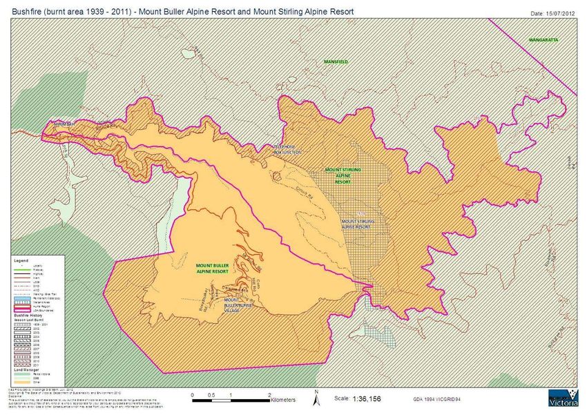
3.1.7 Fire History ........................................................................................................................ 12
3.2 Strategic Implications .......................................................................................................... 13
3.2.1 Vegetation ......................................................................................................................... 13
3.2.2 Weather and Climate ......................................................................................................... 14
3.2.3 People................................................................................................................................ 14
4 MUNICIPAL FIRE MANAGEMENT OBJECTIVE ................................................... 14
4.1 Municipal Objective .............................................................................................................. 15
4.2 Strategic Direction ................................................................................................................ 15
4.3 Alignment of Regional & Municipal Objective ................................................................... 15
5 FIRE MANAGEMENT RISK STRATEGIES ........................................................... 16
5.1 Risk Identification Process .................................................................................................. 16
5.2 Risk Assessment Process ................................................................................................... 17
5.3 Risk Management Strategy .................................................................................................. 20
5.4 Specific Treatments .............................................................................................................. 29
5.5 Fire Management Responsibility......................................................................................... 30
5.5.1 Response Agencies ........................................................................................................... 30
5.5.2 Regulatory and Service Providers ..................................................................................... 30
5.5.3 Community......................................................................................................................... 31
5.6 Balancing Fire Risk Against Other Values ......................................................................... 31
iv | P a g e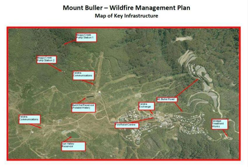
Mount Buller and Mount Stirling Draft Municipal Fire Management Plan V2
5.7 Cross boundary Management and Links to Other Programs/Processes ....................... 32
6 IMPROVEMENT AND PLAN REPORTING AND REVIEW PROCESS ................. 32
7 ATTACHMENTS ..................................................................................................... 34
Attachment 1: Risk Assessment Tables ........................................................................................ 34
Attachment 2: Stakeholder Analysis & Community Engagement Plan ...................................... 37
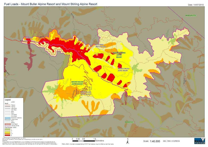
Attachment 3: Environmental Scan maps & data ......................................................................... 42
Attachment 4: HAZARD TREES – IDENTICATION AND NOTIFICATION PROCEDURESError! Bookmark not def
Attachment 5: Neighbourhood Safer Places ................................................................................. 51
Attachment 6: Glossary ................................................................................................................... 52
Attachment 7: Excerpts from Mount Buller Alpine Resort Wildfire Prevention Plan ................ 60
A: Allowable Vegetation Clearances ............................................................................................ 60
B: Map of Fire Breaks ................................................................................................................... 61
C: Map of Key Infrastructure ......................................................................................................... 62
D: Mount Buller Alpine Resort Wildfire Prevention Plan Action Table ......................................... 63
Table of Figures
Figure 1: Fire Management Planning ............................................................................................................1
Figure 2: Victorian Management Plans and Policies ..................................................................................2
Figure 3: Integrated Fire Management Planning Process ..........................................................................4
Figure 4: IFMP Alignment with AS/NZS ISO 31000:2009 ............................................................................5
Figure 5: IAP2 Public Participation Spectrum .............................................................................................5
Figure 6: Fire Management Roles .................................................................................................................6
Figure 7: Stakeholder Type and Engagement Level ...................................................................................6
Figure 8: Mount Buller and Mount Stirling Alpine Resorts ........................................................................9
Figure 9: Fire Influenced and Fire Sensitive Vegetation, ARMB Area ....................................................11
Figure 10: Alignment of MFMP & RSFMP objectives ................................................................................16
Figure 11: Chrighton’s Risk Pyramid .........................................................................................................17
Figure 12: Mount Buller and Mount Stirling Risk Assessment ................................................................18
Figure 13: Mount Buller and Mount Stirling Risk management strategy................................................20
Figure 14: Mount Buller and Mount Stirling Specific Treatments ...........................................................29
Figure 15: Mount Buller and Mount Stirling MFMP Reporting and Evaluation Program ......................33
v|Page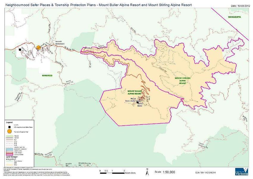
Mount Buller and Mount Stirling Draft Municipal Fire Management Plan V2

1 Introduction
1.1 Context and Background

Victoria has a long history of community, government and organisations working cooperatively to
combat the threat of bushfire. However recent challenges such as the decade of dry conditions,
an increase in people living in high risk areas and the occurrence of a number of major fires,
prompted the need for increased coordination and cooperation to secure fire safety across the
state.

In response to these challenges the Victorian               IFMP aims to achieve a
Government   established   an   Integrated     Fire         consistent and effective means
Management Project (IFMP) Framework for Victoria in         for fire management planning
2008.                                                       within Victoria through a
                                                            commitment to cooperation,
IFMP provides a framework for consistent and                including information sharing
effective fire management planning (see figure 1)           and the building of collective
across the fire management continuum, by providing a        knowledge.
multi-agency approach, bringing together fire                – The Integrated Fire Management
management planners and other stakeholders,                 Planning Framework, State Fire
including emergency service agencies, government            Management Planning Committee

departments, private organisations and the community.
Working together they build relationships and share information to plan across public and private
land tenures for all types of fire. IFMP is based on analysis and management of risk, uses best
practices and builds on existing information.

Figure 1: Fire Management Planning

                                                                                           1|Page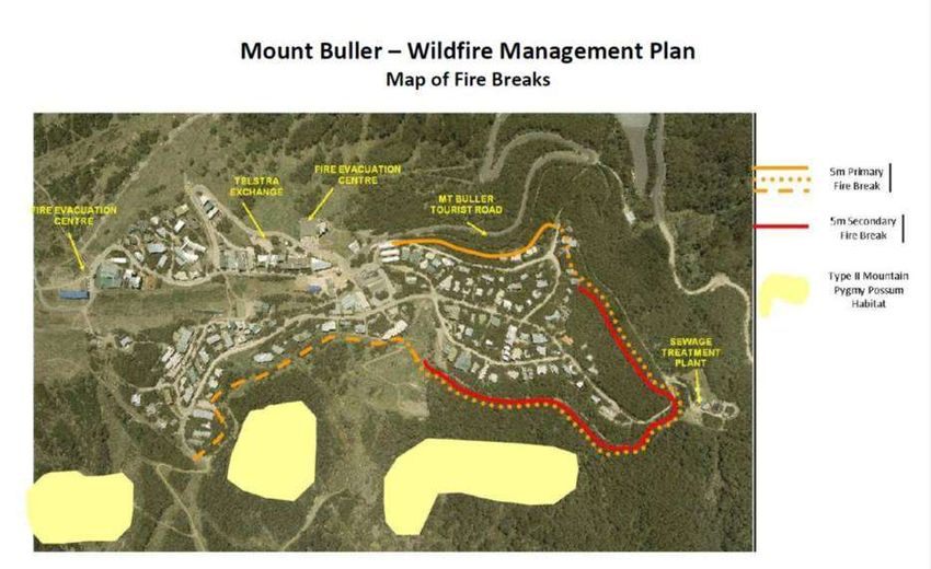
Mount Buller and Mount Stirling Draft Municipal Fire Management Plan V2
Figure 2: Victorian Management Plans and Policies

The framework provides structures, policies and procedures to help build on the existing spirit of
cooperation and networks that already exist in fire management. It establishes a tiered system of
state, regional and municipal plans that provide strategic direction to fire management in Victoria,
as illustrated in figure 2.

The purpose of Municipal Fire Management Committees (MFMPC) is to provide a municipal level
forum for building and sustaining organisational partnerships with
regards to fire management; and to ensure that plans of
individual agencies are linked effectively so as to complement     Mount Buller and Mount
each other. This is facilitated by MFMPCs having a                    Stirling MFMPC
membership consisting                                              membership   consists of:
of representatives from key stakeholder organisations with
respect to fire management within the municipality.                 Mount Buller and
                                                                          Mount Stirling RMB
MFMPCs also act as a sub-committee of their respective
                                                                          CFA
Municipal Emergency Management Planning Committee. Part
6A: Guidelines for Municipal Fire Management Planning, of                 DSE
the Emergency Management Manual of Victoria, outlines the                 Buller Ski LIfts
terms of reference for these committees, identifies their
minimum core membership and requires the development of a
Municipal Fire Management Plan.

The formation of an MFMPC and the development of a MFMP signify an important first step in the
transition from Municipal Fire Prevention Plans developed under the guidance and direction of
Municipal Fire Prevention Committees, to a MFMP developed under the guidance and leadership
of a MFMPC.

1.2 Period and Purpose
Organisation and agencies involved in fire management already have a range of activities, plans,
policies and procedures that are directly involved with, or that impact on fire management. This

                                                                                            2|Page
Mount Buller and Mount Stirling Draft Municipal Fire Management Plan V2
MFMP builds on this existing work, so as to chart and coordinate the implementation of measures
in use across the municipality designed to minimise the occurrence and mitigate the effects of
bushfires. It also seeks to identify the need for adopting or developing new activities, processes
and policies, and communicating this need to the relevant responsible authority.

In doing so it takes into consideration all aspects of fire management;

       Prevention – Regulatory and physical measures to ensure that emergencies are
                    prevented, or their effects mitigated
       Preparedness –       Arrangements to ensure that in the event of an emergency occurring
                    all those resources and services that area needed to cope with the effects
                    can be efficiently mobilised and deployed
       Response –     Actions taken in anticipation of, during and immediately after an
                      emergency, to ensure its effects are minimised and that people affected are
                      given immediate relief and support
       Recovery –      The coordinated process of supporting emergency affected communities in
                      the reconstruction of the physical infrastructure and restoration of
                      emotional, social, economic and physical wellbeing.
MFMPs have a three year planning cycle and this plan has a three year duration commencing
from the date of council endorsement. However it will be subject to annual review and
modification as appropriate. The current MFMP concentrates on bushfires, however it is expected
that future iterations of the plan will further incorporate management of structural and chemical
fires as well as the use of fire for a variety of purposes.

1.3 Preparation Process
This MFMP has been developed in accordance with Part 6A of the Emergency Management
Manual of Victoria and using the IFMP planning process as described in the IFMP Guide. This
process follows a seven stage planning cycle as illustrated in figure 3.

Stage 1: Environmental Scanning – establish a municipal base line from which fire
management planning and decision making can be made and measured, including development
of fire management objectives.

Stage 2: Risk Assessment – identification, analysis and evaluation of the fire risks that
potentially impact on the municipality.

Stage 3: Analysis – analysis of treatment options for achieving the fire management objectives.

Stage 4: Decide – select the most appropriate risk treatment options to achieve the fire
management objectives.

Stage 5: Publish –once the community and stakeholders have validated the draft MFMP, the
relevant authorities endorse, publish and distribute it.

Stage 6: Deliver - relevant organisations implement the agreed risk treatments in the MFMP.

Stage 7: Monitor and Improve – track delivery and effectiveness of risk treatments so as to
continually improve the MFMP’s contribution to realising the fire management objectives.

                                                                                             3|Page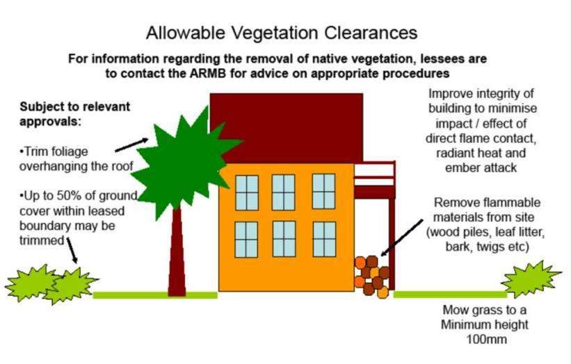
Mount Buller and Mount Stirling Draft Municipal Fire Management Plan V2
Figure 3: Integrated Fire Management Planning Process

Over a period of 12 months members of the committee met on a regular basis to work through the
steps outlined above for the purpose of developing this plan. This commenced with formally
establishing the Mount Buller and Mount Stirling MFMPC as a subcommittee of the Mount Buller
and Mount Stirling MEMPC and endorsing the terms of references based on those in Part 6A of
the Emergency Management Manual of Victoria.

Subsequent activities include undertaking a stakeholder analysis, developing a communications
strategy, identifying and assessing fire risks of concern with the municipality and assigning
appropriate treatments to address them.

This planning process is risk based and aligns with the Australian Standard AS/NZS ISO
31000:2009 Risk Management – Principles and Guidelines, figure 4 describes how this is
achieved.

All concerns identified were considered and defined as risk statements with the cause and impact
clearly described. Each of these risk statements were then assessed using the State Bushfire
Consequence Table, Likelihood table and Risk Assessment matrix (See Attachment 1) as
endorsed by the State Fire Management Planning Committee.

                                                                                           4|Page
Mount Buller and Mount Stirling Draft Municipal Fire Management Plan V2
Figure 4: IFMP Alignment with AS/NZS ISO 31000:2009
2 Engagement and Communications
Stakeholder engagement and participation is an essential element of fire management planning.
Stakeholders are required to participate for a range of reason, including (but not limited to);
Legislative responsibilities in relation to fire management.
Leadership
Provision of hazard expertise and technical advice
Subject to hazard impact – directly and/or indirectly
Land tenure and management arrangements
Expressed expectation
Influenced and/or support mitigation.
Stakeholder engagement is required during all seven stages in the IFMP planning cycle, the aim
being for them to participate together in the collaborative development, delivery and monitoring of
the MFMP.
Engaging with stakeholders in the development and implementation of the MFMP is an essential
tool for drawing on existing knowledge and experience and to build support for and involvement in
this plan.
These communication and engagement tasks have been built around the model of public
engagement developed by the International Association of Public Participation (IAP2). This model
is called the Public Participation Spectrum and is detailed in figure 5 below. This spectrum
provides a framework for planning effective stakeholder engagement about any issue or plan. It is
used as the basis for communication and engagement planning during the development and
subsequent implementation phases
Figure 5: IAP2 Public Participation Spectrum
5|PageMount Buller and Mount Stirling Draft Municipal Fire Management Plan V2
2.1 Community and Organisational Engagement Plan
In accordance with the IFMP planning guide the Mount Buller and Mount Stirling MFMPC
undertook a stakeholder analysis and used this as a basis for the development of a
Communication and Engagement Plan concerning the MFMP.
The stakeholder analysis consisted of a two part process; first identifying the key stakeholders
who needed to be engaged in the MFMP’s development and secondly determining the nature and
level of their interest in fire management planning. This second step involved considering each
stakeholder in relation to eight different fire management roles which are described in figure 6 and
four different stakeholder types as outlined in figure 7.
Figure 6: Fire Management Roles
Role Description
Bringing together of fire management agencies and elements to ensure effective
response to an incident or emergency. CFA has legislated responsibility under the
CFA Act 1958 for the prevention and suppression of fires and for the protection of life
Fire Coordination
and property in the Country Area of Victoria. In accordance with provisions in the
CFA Act 1958 and the Forest Act 1958, DSE has fire management and fire
suppression responsibilities for state forests and national, state and regional parks.
Landholder/managers are heavily involved in fire prevention and fire suppression on
land under their control. They have legislated responsibilities to extinguish a fire
Land
burning on their land and to prevent fires from starting from the use of equipment
Owner/Manager
and vehicles (CFA Act 1958, Crimes Act 1958). They are also required to comply
Responsibilities
with relevant local government laws, relevant planning or building permit conditions
and conditions associated with permits to burn.
Actions taken in anticipation of, during and immediately after a fire incident to
Response
minimise the impact of the fire.
A coordinated process of supporting emergency affected communities in the
Recovery reconstruction of physical infrastructure and restoration of emotional, social,
economic and physical wellbeing.
Community Community education is learning and social development, working with individuals
Education and groups in their communities using a range of formal and informal methods
Community care is about identifying and catering for groups or individuals with
Community Care
specific needs, before during and after fire.
Asset protection involves protecting key community infrastructure such as power,
water supplies, roads, gas pipes and protecting community assets such as parks and
Asset Protection
the environment. Asset protection can also involve the protection of private assets
such as housing, plantations, crops and fences.
The issuing of permits for lighting fires. The development of and compliance with
planning controls and permits for developments and building that take into account
Regulatory
fire risk/management. The regulation and issuing of permits involving vegetation
removal or fuel reduction activities for fire management purposes.
Figure 7: Stakeholder Type and Engagement Level
Stakeholder Participation
Description
Type Level
Internal Formal responsibilities for IFMP process and outcomes Collaborate and
empower
Primary MFMPC membership, responsibility for development of the plan, Collaborate and
communication and engagement across and within organisations rest empower
with these organisations
Secondary RSFMPC membership or fire management role within municipality, may Involve and
be requested to provide specific inputs, dependent upon outputs, or consult
requested to be involved in specific tasks,
Tertiary Strong interest in outcomes and may have valuable Inform and consult
information/viewpoints to share
6|PageMount Buller and Mount Stirling Draft Municipal Fire Management Plan V2
Once a stakeholder had been categorised, the appropriate level of participation in the process
and the different types of engagement activities required were determined. The results of this
stakeholder analyses and the resulting Communication and Engagement Plan can be found in
Attachment 2.
2.2 Community Engagement
During the development phase of the MFMP the Mount Buller and Mount Stirling MFMPC’s
communication and engagement efforts were focused primarily upon the key stakeholders.
However a number of community groups were identified as Tertiary stakeholders and engaging
with them and the broader community is seen as a critical component to the long term success of
MFMP.
This community engagement process is very much seen as an ongoing responsibility of the
Mount Buller and Mount Stirling MFMPC and it is expected to gain prominence going forward
once the plan is endorsed and especially during review periods. Consequently the
Communication and Engagement Plan should be viewed as a live and evolving document that will
be shaped according to the MFMPC’s needs over time. In this manner it will be able to guide the
process of broader community engagement with additional activities and details being
incorporated as required.
It is also anticipated that in addition to the activities attributed to the MFMPC, individual key
stakeholders will be utilising their existing processes and undertaking their own community
engagement activities in support of IFMP and the MFMP.
3 Environmental Scan
Environmental scanning involves identifying key themes, issues, trends and gaps that may affect
or influence fire management. It establishes the base level of knowledge and understanding
required for supporting risk identification, risk assessment and risk treatment within a fire
management context.
It involves gathering and interpreting data and information relevant to fire management, so as to
make predictions, assumptions and conclusions concerning fire risk for the Resorts over the
period of the plan. It also provides the basis for identifying fire management objectives and
decision making with regard to selecting strategies to achieve these objectives.
In undertaking this environmental scanning exercise the MFMPC gathered information relevant to
fire management from a wide range of sources. Data sources used included the CFA’s VFRR,
DSE Fuel loads and natural values, OESC Consequence of Loss and ABS IRSED. This
information was interpreted using the committee’s extensive knowledge and experience with fire
management to make predictions, assumptions and conclusions concerning fire risk for the
municipality over the period of the plan.
3.1 Alpine Resort Profile
3.1.1 Location and Tenure
Mount Buller and Mount Stirling Alpine Resorts are surrounded entirely by Mansfield Shire but are
managed independently by the Mount Buller and Mount Stirling Alpine Resorts Management
Board (“RMB”).
The RMB was created in 2004 and is charged under the Alpine Resorts (Management Act) 1997
with the management of the areas of Mount Buller and Mount Stirling Alpine Resorts. The RMB is
therefore a statutory body and works as a committee of management over the Crown Land area
of the Resorts. The RMB delivers a number of services on the mountain including providing
services such as garbage disposal, water supply, sewage, roads, fire protection and snow making
7|PageMount Buller and Mount Stirling Draft Municipal Fire Management Plan V2
and developing tourism and marketing strategies for promoting the Resorts. The RMB is also
responsible for the protection, enhancement and restoration of the natural and cultural heritage of
the Resorts.
The Resorts are Alpine areas located to the west of the Great Dividing Range and snow can fall
at any time of the year particularly in areas above 1,200 metres in elevation. The resorts both
have similar natural topography and vegetation and cover an area of just under 5,000 hectares.
They are both approximately 250km from Melbourne and 46 km from Mansfield.
Mount Stirling Alpine Resort’s lowest point is 603 metres (above sea level) at its western margin
on the Delatite River at Mirimbah. The summit of Mount Stirling is its highest at 1,749 metres.
Similarly, Mount Buller Alpine resort rises from the 603 metre mark at Mirimbah on its western
margin to the summit of Mount Buller at 1,805 metres. The ski field and village is generally
situated between 1,400 meters and 1,800 metres
Both of the resort boundaries are generally defined by the 1,300 to 1,350 metre contour line with
approximately 67% or 3,296ha of the Resorts above 1,300m. The Resorts abut the Alpine
National Park to the south and southwest and the Mansfield State Forest on other boundaries.
DSE and Parks Victoria and the Shire of Mansfield are major land managers around the resort
areas.
3.1.2 Population and Demographics
Mount Buller Alpine Village a permanent residential population of less than 100 during the warmer
months. Over the winter period the total number of people using the resort during the day can
reach 16,000 and the village can accommodate up to 8,000 people in private apartments,
commercial premises, ski lodges and staff accommodation. During the ski season from June to
September, approximately 250,000 people visit the resort. Over the summer period, this is
reduced to approximately 150,000 visitors.
There are no permanent residents living on Mount Stirling. Total annual visitor numbers are
estimated at 50,000 with the majority of people visiting the area during the summer months.
These summer visitors consist of four wheel drivers (57%) and sightseers (25%). Other visitors to
the area can include horse riders, bushwalkers, school groups, orienteerers and mountain bike
riders. There are no lif
t facilities at Mount Stirling and winter visitors participate in cross country skiing, back country
snowboarding and snow play. In summer many people pass through the resort to get to Craig’s
Hut, the surrounding state forest or the Alpine National Park. There is only ski patrol
accommodation on the mountain and visitor accommodation is not catered for other than in
permanent refuge huts or temporary campsites. A number of people and groups regularly camp,
in both summer and winter, within the boundaries of the resort.
3.1.3 Natural Environment
Due to their altitude and topography, the resorts are situated at the headwaters of one of the
major rivers in northeast Victoria: the Goulburn River. They also form part of the Ovens River
catchment. Mount Buller Resort area includes the headwaters of the Howqua and Delatite Rivers
and Mount Stirling Resort, the Delatite, Howqua and King Rivers. A number of smaller tributaries
occur in both resort areas including Boggy Creek, Buller Creek and Chalet Creek which all feed
into the Delatite River. The Howqua River tributaries include Black Dog Creek, Cow Camp Creek,
Gin Creek, Whisky Creek, Little Buller Creek and South Buller Creek.
At Mount Buller the water supply is sourced from Boggy Creek where it is pumped into reservoirs
at Burnt Hut and Baldy. The Mount Buller Waste Treatment Plant treats sewage and discharges
to the Black Dog Creek. Water supply for Mount Stirling (TBJ) is sourced from Falls Creek.
8|PageMount Buller and Mount Stirling Draft Municipal Fire Management Plan V2
Figure 8: Mount Buller and Mount Stirling Alpine Resorts
9|PageMount Buller and Mount Stirling Draft Municipal Fire Management Plan V2
The Resorts are both heavily vegetated with Dry (Montane) and Wet (Sub Alpine) Forests.
Within the Montane vegetation community, the most common tree species are Mountain Ash
whilst the sub-alpine regions most commonly contain Snow Gum. Some sub-alpine woodland,
approximately 300 hectares, has been cleared around the summit of Mount Buller to provide ski
runs and areas for the village. At Mount Stirling, the Mountain Ash was extensively logged in the
past and the regrowth is generally less than 60 years old. Near the summit of Mount Stirling 200
hectares, which is alpine, has no trees. Snowy Grass and Heath are the dominant forms of
vegetation in this area.
319 species of plants have been recorded within the resorts boundaries. Of these, 38 species are
considered to be threatened. One threatened plant community also exists within the Resorts –
Alpine Sphagnum Bogs and associated Fens Community.
The Alpine Resorts vegetation types have been mapped as either fire sensitive or fire influenced
vegetation types. Fire sensitive vegetation types include plants that may be either damaged or
killed by fire. Fire influenced vegetation refers to the influence fire can have on vegetation
structure by favouring or eliminating certain plants. Figure 9 below includes the mapped areas of
fire sensitive and fire influenced vegetation in Mount Buller and Mount Stirling Alpine Resorts.
Indigenous fauna, including 26 types of mammals, 56 varieties of birds, 8 species of reptile and
five frog taxa have been recorded within 5 kilometres of the resorts. Invertebrate fauna within the
Resorts is largely unknown although some species, such as the Bogong Moth (Agrotis infusa) are
common in the resort areas. 8 rare or threatened fauna have been recorded within the Resorts,
whilst a further 14 have been recorded within 5kms of the Resorts. The most well known of these
is the Mountain Pygmy-Possum (Burramys parvus) who heavily exploit the Bogong Moth as a
food source during the breeding season.
The Mountain Pygmy-possum, listed as endangered at state and national levels, is a small mouse
sized marsupial of approximately 45 grams, is restricted to a few known alpine sites in Australia,
in the Bogong High Plains and Mount Hotham in Victoria and Mount Kosciusko in New South
Wales. The Mount Buller population is the most southern population and is isolated and therefore
genetically distinct from other populations. It was discovered on Mount Buller in 1996. In 1996 the
population was estimated at 300 adult females but dropped to less than 100 in 2004.
3.1.4 Land use, Economy and Employment
The Alpine Resorts rely on Tourism for their income with Resorts entry, site rental fees and
service charges making up the main income of the Resorts. Both the Resorts of Mount Buller and
Mount Stirling are used by visitors for a range of winter activities including downhill and cross
country skiing, snow boarding and snow play. Summer activities include bushwalking, camping,
mountain biking, horse riding and four wheel driving.
Buller Ski Lifts are the major employer on the mountain, employing up to 800 people over the
winter ski season. Jobs include retail, hospitality, lift operation, mountain operations, ski and
snowboard school, transport, ticketing, sales and administration staff. Approximately 1000 people
are employed in total at Mount Buller during the ski season. The Mount Buller and Mount Stirling
Alpine Resort Management Board generates an annual revenue of approximately $12 million.
Mount Buller has traditionally been a winter resort but recent figures show an increasing trend of
summer visitation. There was a recorded 19% increase in visitors from the summer of 2010-11 to
the summer of 2011-12. Mount Stirling is the only Alpine Resort that attracts more visitors over
the summer period and consistently records approximately 20-30,000 summer visitors a year.
The Mount Buller road sees significant traffic during the winter (up to 1,700 vehicles per day).
10 | P a g eMount Buller and Mount Stirling Draft Municipal Fire Management Plan V2
Figure 9: Fire Influenced and Fire Sensitive Vegetation, ARMB Area
11 | P a g eMount Buller and Mount Stirling Draft Municipal Fire Management Plan V2
3.1.5 Traditional Owners
Both Mount Stirling and Mount Buller Alpine Resorts lie in the traditional territory of the
Taungarung (or Daung wurrung) language group which covered a large part of central Victoria.
Unfortunately, there is a lack of ethnographic information relating to the Aboriginal people in and
around the Alpine resorts. Evidence for Aboriginal groups and tribal boundaries comes from
recorded sites within the resorts and observations made by Europeans during early settlement
and contact.
There is one Registered Aboriginal Party (RAP) in the area of the Alpine Resorts; the Taungurung
Clans Aboriginal Corporation (TCAC). RAPs have responsibilities relating to the management of
Aboriginal Cultural Heritage under the Aboriginal Heritage Act 2006. These responsibilities
include evaluating Cultural Heritage Management Plans, provide advice to applications for
Cultural Heritage Permits, making decisions on Cultural heritage Agreements and offer advice or
applications for Protection Declarations.
For further information about RAPs and their contact details see:
http://www.dpcd.vic.gov.au/indigenous/aboriginal-heritage-council/registered-aboriginal-
parties
3.1.6 Climate
Mount Buller and Mount Stirling are characterised by Alpine weather patterns and both can have
snow fall at any time of year. Average summer temperatures vary from 6.6 C° to 15.5 C° and
average winter temperatures vary from -2.8 C° to 1.6 C°. Mount Buller Weather Station records
an average rainfall of 1,530.9mm and has varied as much as 633mm (in 1995) to 1971.4mm (in
1989). As a comparison, the Weather Station at Mansfield Post Office averages 705.7mm of
annual rainfall but has varied to as low as 318.4mm (in 2006) and as high as 1093.2mm (in 1956).
The future climate in the greater Goulburn-Broken region is expected to become hotter and drier
than it is today1. It is also expected that there will be a larger proportion of hotter days, fewer
frosts and a greater incidence of drought2. Higher intensity, but lower predictability, of rain events
is also likely to occur with less rain available for irrigation. These climactic changes will influence
and possibly increase the likelihood of fire in the Resorts. These climactic changes will directly
affect Alpine areas as less snow may fall during winter.
By 2030 it is predicted that the average temperatures in the region will increase by 0.8°C and by
2070, depending on emissions, temperatures will increase on average by 1.4°C to 2.7°C. The
climate is likely to become increasingly erratic with higher occurrences of heat waves, storms and
frosts. These climactic changes will also make fire behaviour harder to predict.
3.1.7 Fire History
Large wildfires approached the Resort in the summer of 2002-2003 and again in 2006-2007
(December to late January).
The CFA has a brigade located at the Mount Buller Alpine Resort. In the 10 years prior to July
2011 Mount Buller CFA has responded to:
1
CSIRO and BOM 2012. State of the Climate 2012, Commonwealth Scientific and Industrial Research Organisation, Bureau of
Meteorology.
2
DSE, 2008. Climate change in Goulburn Broken, Department of Sustainability and Environment, Victoria, Melbourne
12 | P a g eMount Buller and Mount Stirling Draft Municipal Fire Management Plan V2
260 False Alarms/ False Calls
31 MVA/ rescue
83 Fire and Explosion calls
16 Specific Building Fires
3.2 Strategic Implications
Bushfire can occur in any type of vegetation, such as grassland, trees or shrubs. This section
describes the Mount Buller and Mount Stirling Alpine Resort areas and factors that increase the
likelihood of a fire starting and spreading across this region. Ensuring the Alpine Resorts are a
safe and healthy place to recreate and work, involves protecting the social, environmental and
economic fabric of the resorts.
Mount Buller and Mount Stirling Alpine Resorts have a range of assets and features which make
them a vibrant place to work or visit. Located within the Mount Buller Alpine Resort is the Mount
Buller Alpine Village which has a range of infrastructure focused on the snow and skiing industry.
It provides a diverse range of accommodation and entertainment facilities, Ski and snowboard
hire, restaurants and pubs. Infrastructure also exists on Mount Buller to provide
telecommunications, water, gas, power and waste water treatment. Mount Stirling does not have
accommodation facilities but has some limited infrastructure located at Telephone Box Junction
including a Ski Patrol building, ski hire shop, a public shelter, small bistro, a generator and toilet
block.
In addition to the built environment the Alpine Resorts boast a range of natural assets such as
montane woodland dominated by Alpine Ash (Eucalyptus delegatensis) , and sub alpine areas
where the predominant tree is Snow Gum (Eucalyptus pauciflora). Also there are areas above
the tree line where trees cannot exist which are dominated by snow grasses and heath. These
areas are highly valued for their environmental, commercial and visual aesthetics.
Although highly valued for their natural values, the resorts contain large tracts of remnant
vegetation which could subject the Alpine Resorts to possible bush fires in the warmer months.
Similarly, the range of topography present in the Resorts presents a number of challenges to fire
fighting as access to some areas is difficult or impossible.
3.2.1 Vegetation
The vegetation and topography of the Mount Buller and Mount Stirling Alpine Resorts create a
number of challenges for fire management. There is an diverse range of vegetation types spread
throughout the resort areas including Montane Dry Woodland, Montane Damp Forrest, Shrubby
Dry Forest, Damp Forest, Wet Forest, Herb-Rich Foothills and others. Corresponding fuel loads
can also vary to a large degree throughout the resort areas. For example sub-alpine treeless
mosaic occurs on the summit areas where tree growth is limited due to climactic extremes.
These areas are dominated by snow grasses and herbs. Below these areas are the higher
elevated ridges and upper slopes support sub-alpine woodlands, dominated by Snow Gum
(Eucalyptus pauciflora). Further downhill, these sub-alpine woodlands give way to Alpine Ash
(Eucalyptus delegatensis) and Mountain Gum (Eucalyptus dalrympleana ssp) Forests. Some
sheltered gullies in these areas also support Wet Forests and Montane Riparian Thicket. Damp
Forest and Wet Forest are generally located on the lower southern slopes within the resorts.
Herb-rick Foothill Forest is confined to the lower slopes and gullies in the resort areas. Each of
these vegetation types is associated with differing fuel loads and an understanding of them is
essential to predict fire behaviour.
The Alpine Resorts also have a number of steep escarpments and highly varying topography, are
heavily vegetated and have little access or egress and have a number of water courses flowing
13 | P a g eMount Buller and Mount Stirling Draft Municipal Fire Management Plan V2
through them. All of these combine to make fire control and response in these areas difficult as
locating and accessing fires with emergency equipment can be difficult.
3.2.2 Weather and Climate
Weather conditions and climate also impact on fire management in Mount Buller and Mount
Stirling Alpine Resorts. For instance the bushfire season from 2000-2009 was increased in length
due to the wide-spread impact of severe drought. In more recent years, summers have been
milder and have had more rainfall, a condition which is predicted to change in the foreseeable
future. Typically the Alpine Resorts experience spring rains and mild conditions that promote
growth followed by mild to warm summers which lead to high fuel loads.
The usual pattern during summer months of north westerly winds accompanied by moderate to
high day time temperatures and low relative humidity building up over several days to a storm
event with a change to south westerly winds. This creates a situation whereby fire ignition from
lighting becomes a likely possibility, with a propensity for the fire to run quickly in one direction
before changing direction quickly, thus transforming the fires extensive flank into the new fire
front.
With current trends and thinking in climate change, research modelling suggests the future
climate will be warmer, drier and less predictable. We can therefore expect an increase in the
number of extreme fire danger days as well as longer fire seasons.
3.2.3 People
Mount Buller and Mount Stirling Alpine Resorts have experienced a number of fires in recent
years. Their combination of topography, climate and vegetation coupled with the increasing
number of people visiting high fire risk localities during the fire danger period poses a significant
issue for the Alpine Resort area. Both Mount Buller and particularly Mount Stirling are
experiencing a growth in tourist numbers in the warmer months with holiday makers drawn to the
area by milder summer conditions compared with non-alpine areas and for their natural values.
Mount Buller and Mount Stirling Resorts have people with different perspectives and different
needs in regard to fire and fire safety. Understanding these needs is central to delivering effective
community safety initiatives. This is particularly important for people new to the area or those that
recently experienced a severe fire event.
Tourism also has considerable impact on human movement during the fire danger period,
interacting with fire management at several points, particularly in the heavily forested areas
around Mount Stirling and surrounding the Mount Buller Alpine Village. The same landscape
features that may lead to increased fire danger, can also be underpinning elements of what
makes the site attractive for tourism. Furthermore visitor numbers tend to increase as the fire
season advances creating a situation of increasing potential impact as the fire risk rises.
4 Municipal Fire Management Objective
The Municipal Fire Management Objective provides a framework for considering, selecting and
evaluating fire management activities. This objective was developed using the information
examined during the environmental scanning process, as well as being informed by the Hume
Regional Fire Management Plan and relevant issues and priorities from regional stakeholders and
adjoining municipalities.
14 | P a g eMount Buller and Mount Stirling Draft Municipal Fire Management Plan V2
4.1 Municipal Objective
The fire management objective of Mount Buller and Mount Stirling MFMPC is;
Mount Buller and Mount Stirling Alpine Resort working together to plan for, respond to,
recover from and reduce the risk of fire to the unique Alpine community, environment and
economy
4.2 Strategic Direction
In developing strategic directions for the MFMP the MFMPC was mindful of the planning context
within which they were undertaking this task. As illustrated in figure 2 the MFMP forms a critical
third tier in the State of Victoria’s Fire Management Planning hierarchy and therefore must not be
developed in isolation from State and Regional level fire management plans. The MFMPC are
keen to ensure any actions within the MFMP’s support and complement any relevant State
objectives and strategies with regard to fire management. Consequently they have adopted the
following broad strategic directions from the State Fire Management strategy 2009
Active participation of the community, the sector and government, working together in fire
management planning to reduce the destructive impact of fire on communities and the
environment.
Communities that are resilient to fire.
Greater understanding of the fire sector within the community.
Healthy natural, social and built economic environments.
4.3 Alignment of Regional & Municipal Objective
The Mount Buller and Mount Stirling municipal fire management objective aligns closely with the
Hume RSFMP objectives and vision for fire
management. The development and
implementation of this plan will therefore Hume Regional Fire Management Vision
contribute significantly to the realisation of The Hume Region working together to
the Hume RSFMP’s vision. effectively anticipate, respond to and
recover from major bushfire – to secure a
Furthermore the formation of the Mount safer region, more resilient community,
Buller and Mount Stirling MFMPC and the healthier environment and a prosperous
development of a MFMP using the economy.
designated IFMP Planning Guide have
strongly supported several of the RSFMP’s
key objectives. Evidence of this is described in the following table.
15 | P a g eMount Buller and Mount Stirling Draft Municipal Fire Management Plan V2
Figure 10: Alignment of MFMP & RSFMP objectives
RSFMP element RSFMP objective MFMP contribution
Planning together Develop state, regional, municipal and The MFMP provides the third tier in the IFMP
local fire management plans and process and utilises the same risk base approach
planning with a clear purpose and a as used with State and Regional plans
consistent assessment of risk.
Collaborative Develop and implement fire The MFMPC consists of multiagency
implementation management programs and activities in representation and has incorporated community
a collaborative manner. engagement strongly into the development of the
MFMP.
Building knowledge & Build and share knowledge in the fire The aspirations of the MFMPC converge with the
capacity: management sector and across the regions in seeking to build both its members and
community. the communities’ knowledge and understanding of
fire management.
Improve the capability of communities,
the fire management sector and the
government to deal with fires.
Implementation support Support the implementation of the IFMP The development of this MFMP clearly
framework in the Hume region demonstrates support for IFMP at a municipal
level.
5 Fire Management Risk Strategies
Integrated fire management planning is the risk management process to establish priority setting
for fire management activities and is consistent with the international standard for risk
Management ISO 31000. Risk is described within the standard as;
Risk Analysis = Consequence x Likelihood
And the standard emphasises the need to establish and manage the risk to the objectives that
you have set during the plan development process.
5.1 Risk Identification Process
These objectives and risks were identified through the environmental scanning process and
primary to this process is Chrighton’s Risk Pyramid. Chrighton’s Risk Pyramid provides a
framework for sorting, analysing and assessing information with respect to fire risk. It helps
identify the amount of risk generated by the hazard x exposure x vulnerability relationship within
the context (people, property, infrastructure, social and economic, biodiversity, the economy and
heritage values) of a location or situation. Where;
Hazard - is a specific event characterised by a certain magnitude and likelihood of
occurrence
Exposure - refers to the factors, such as people, buildings, networks the environment and
economy that are subject to the impact of a specific hazard
Vulnerability - refers to the characteristics of an element exposed to a hazard - road,
building, person, and economy – that contributes to the capacity of that element to resist,
cope with and recover from the impact of a natural hazard.
16 | P a g eMount Buller and Mount Stirling Draft Municipal Fire Management Plan V2
Figure 11: Chrighton’s Risk Pyramid
By this means the MFMPC was able to generate a list of bushfire risks for the Resorts. As IFMP
encompasses planning across all fire hazard environments, hazards need to be considered within
a range of categories, so as to better understand the likely consequences and recovery risks
involved. A copy of these categories can be found in Attachment 1.
5.2 Risk Assessment Process
Risk is assessed by determining consequences and the likelihood of the consequence occurring,
and the elements at risk. An event or set of circumstances may have multiple consequences and
may affect multiple objectives. Existing risk treatments and their effectiveness should be taken
into account when rating the level of risk.
As a first step in the assessment process each of the identified risks were refined into succinct
risk statement and entered into the Risk Register. Risk statements are a description of the risk
and simply describe the risk in terms of the source through to the impact. Each risk statement
should outline:
the hazard (source of risk)
the element at risk
the consequence of the interaction as a result of an event.
Each of these statements was then qualitatively assessed for their impact using the State Fire
Management Planning Committee’s State Bushfire Consequence Table (Attachment 1). Each
consequence was considered in terms of both damage and disruption (loss of service or function)
and in some cases, the consequence of an event was not realised at the local, level but was of a
significant impact at regional and/or state level. In addition the committee took into account
existing treatments and their impact on the risk level. Consequence ratings were then entered into
the risk register.
17 | P a g eMount Buller and Mount Stirling Draft Municipal Fire Management Plan V2
The likelihood of each an event being realised was assessed using the data derived from the
environmental scan and the Likelihood Table (Attachment 1). Where the committee did not
believe it held the necessary technical expertise to make an assessment, advice was sought from
relevant authorities outside the committee. Once agreement as to Consequence and Likelihood
was reached the Likelihood x Consequence matrix (Attachment 1) was used to assign a risk level
to each risk statement.
The following figure (12) is a summary of the risk assessment process, detailing the highest
priority bushfire risks at the Mount Buller and Mount Stirling Alpine Resorts. The priority risks were
determined by the combined fire experts on the MFMPC which utilised the fire experience of
committee members, the VFRR risk register and the former Mount Buller and Mount Stirling Fire
Prevention Plan.
Figure 12: Mount Buller and Mount Stirling Risk Assessment
ID
RISK DESCRIPTION CAUSE IMPACT COMMENT
#
Risk to people, Loss of life, assets and
Access/egress limited, includes
infrastructure and staff lightning, human infrastructure, time and
1 Mirimbah store, campground, park
at the Mirimbah factors cost of recovery, impact
and river area (as per VFRR)
Precinct from fire on tourism
Risk of structural fire human factors, Loss of life, assets and
Access/egress limited, depends on
during both winter and mechanical infrastructure, time and
the type of building/role of building
2 summer months failure, equipment cost of recovery, impact
(eg: staff accommodation, treatment
impacting infrastructure, failure, natural on tourism, loss of
plant)
people and employees. (lightning) accommodation
Risk of structural fire
spreading to become a
human factors, Loss of life, assets and
bushfire potentially Area contains habitat for nationally
mechanical infrastructure, time and
impacting upon threatened species, large number of
3 failure, equipment cost of recovery, impact
infrastructure, people, empty buildings (detection of fire
failure, natural on tourism,
employees and may take time)
(lightning) environmental impacts
environmental values
during warmer months
Risk to people in transit human factors,
up or down Mount mechanical Access/egress is limited (one road in
Loss of life, reduction in
4 Buller or Mount Stirling failure, equipment and out), mountain not shut on Code
public confidence
from fire during the failure, natural Red days.
warmer months (lightning)
Risk from recreational
human factors,
users in the park areas
mechanical No event caused by people in last 50
5 as a source of ignition Loss of Biodiversity
failure, equipment years
of bushfire during the
failure
warmer months
Risk to recreational human factors, Loss of life, assets and
users in the park from mechanical infrastructure, time and Includes: Horse riding, mountain
6 bushfire during the failure, equipment cost of recovery, impact bikes, 4wd users, campers,
warmer months of the failure, natural on tourism, bushwalkers
year (lightning) environmental impacts
18 | P a g eYou can also read