BARCELONA GIVES WAY TO GREEN INFRASTRUCTURE - DIVA
←
→
Page content transcription
If your browser does not render page correctly, please read the page content below
DEGREE PROJECT IN CIVIL ENGINEERING AND URBAN
MANAGEMENT,
SECOND CYCLE, 30 CREDITS
STOCKHOLM, SWEDEN 2019

Barcelona gives way to
green infrastructure
Les Glòries urban transformation as a case study
of citizen participation

ARIADNA BARÓ PLANELLA

KTH ROYAL INSTITUTE OF TECHNOLOGY
SCHOOL OF ARCHITECTURE AND THE BUILT ENVIRONMENT

Summary
Nowadays, there are more population concentrated in urban areas rather than in rural areas. This
process of urbanization has altered natural processes in addition to landscape modification. The
green in cities has become more and more fragmented, leading to the degradation and loss of
many ecosystem services. The big expansion of Barcelona happened during the Cerdàs Plan in
the middle of the 19th century. Cerdà designed Barcelona as a grid of blocks where people could
walk through its streets and rest in big green areas, but, left some parts of the city like Les Glòries
without any planning due to its complexity. In the years thereafter, the city of Barcelona has
become a compact city, densely populated, with scare and isolated green spaces while the public
space becomes mainly dominated by the car.

In order to face the current issues of Barcelona, its City Council has implemented several
measures like the green infrastructure strategic policy and planning. Although they have not been
done with citizen participation, this supposed a paradigm shift on the municipal city planning, as
well as, a paradigm shift on Barcelona’s city model where green infrastructure is being used as
an adaptation measure to mitigate the effects of climate change and as a strategic planning tool
for reducing car traffic.

The project of Les Glòries is a landmark of how a place planned as car-based could become
pedestrian-based, in addition to the second biggest green space of the city of Barcelona. Becoming
a reference for the new city council policies and measures for a more sustainable and participative
Barcelona. Les Glòries project is also a referent of citizen participation due to the citizens and
neighbourhood associations were from the very beginning in the planning and design of this space
together with the city council technicians.

Keywords
Green infrastructure, Barcelona, Les Glòries, Citizen Participation, Sustainability in cities.

Acknowledgements

Thanks to Francesc Baró, Miquel Catasús, Jaume Badenes, Rosa López, Cynthia Echave and
Coloma Rull for your time and for letting me interview you.

Thanks to my supervisors Lina Suleiman and Elisabeth Roca for introducing me in the world of
the green infrastructure and for your help, confidence and freedom during the realization of this
thesis.

Last, and most important, thanks to my parents and loved ones for your support and love.

                                                  1
Table of Contents
Summary ....................................................................................................................................... 1
Acknowledgements ....................................................................................................................... 1
Table of Contents .......................................................................................................................... 2
1. Introduction ............................................................................................................................... 3
2. Methods ..................................................................................................................................... 6
   2.1. Interviews ........................................................................................................................... 6
   2.2. Surveys Analysis ................................................................................................................ 7
3. Theory ....................................................................................................................................... 8
   3.1. Urban green and Green Infrastructure (GI) ........................................................................ 8
   3.2. Social urban movements and Citizen Participation .......................................................... 12
4. Case study: Les Glòries in Barcelona city............................................................................... 15
   4.1. Brief historical review of Barcelona’s Urban Transition and Transformation ................. 15
   4.2. Introducing the area of Les Glòries .................................................................................. 17
5. Development and analysis of results ....................................................................................... 20
   5.1. Revision of urban sustainability policies in Barcelona .................................................... 20
   5.2. Green Infrastructure policy and planning in Barcelona ................................................... 22
   5.3. The process of Les Glòries urban transformation: From the square that never was to the
   second biggest park of Barcelona............................................................................................ 33
6. Discussion of results ............................................................................................................... 44
   6.1. Barcelona’s GI policies and plans for a more sustainable urban city model .................... 44
   6.2. Green infrastructure as an infrastructure of the city ......................................................... 45
   6.3. The benefits of citizen participation in green infrastructure planning ............................. 46
7. Conclusions ............................................................................................................................. 48
References ................................................................................................................................... 50
Appendices .................................................................................................................................. 56

                                                                        2
1. Introduction
Historically, the growth of cities in the global north has occurred as a result of the population
migration from rural areas to urban areas due to the industrial revolution and the improvement of
the agricultural techniques (Farrell, 2017), happened in the XVIII century. Since then, a greater
number of a rural population rather than urban provided a continuous supply of rural migrants to
replace the labour force required in urban areas. Where, over time, advances in medicine have
reduced mortality and have increased the life expectancy. Circumstances that had fostered a
transition towards an urban society as a result of a rural to urban migration, the urban natural
population increase and the reclassification of rural areas as urban (Farrell, 2017).

This process of urbanization, where more people are concentrated in urban areas than in rural
areas, have required the expansion of the cities hinterlands in order to solve this increase of
population by transforming the land uses of the peri-urban interface, from rural to urban land.
This changes in response to the population and city needs suppose the alteration of natural areas,
hindering lots of natural processes such as wildlife migrations, natural water flows, infiltration or
pollination among others, together with the alteration of the landscape modifying the land uses
for agricultural, residential, commercial and industrial purposes. The fragmentation and
degradation of natural ecosystems lead to the demean and loss of the ecosystem services (MEA,
2005).

As it is said by (Calaza-Martínez, 2016) “The rapid and disproportionate urban population growth
added to the massive population migration generates overpopulated cities, with low liability,
basically without open and green spaces”. This generates a lack of housing or bad quality housing,
no social cohesion and health problems aggravated with intensive car traffic in cities. In addition,
the lack of soil permeability increases the risk of flooding and exacerbates the heat island effect.

Barcelona nowadays is the second most populated city in Spain with a registered population of
1,620,809 inhabitants (Departament d’Estadística i Difusió de Dades, 2018) and 3,665,687
(Eurostat, 2018) inhabitants taking into account its metropolitan area. Due to the morphological
characteristics of its territory, the city of Barcelona has not been able to grow in size, so it has
been densifying itself, becoming compact city with semi-tall buildings of 5–6 stories and mostly
narrow streets having a net density of 6.6 inhabitants per km2 (Departament d’Estadística i
Difusió de Dades, 2018). Moreno-Garcia (1994, p.710) has shown that because of this
compactness, the city of Barcelona suffers from a heat island effect, where the downtown
temperatures can be ≤ 8 °C higher than the less compact areas.

Car traffic is one of the most important issues that must need to be faced in Barcelona. According
to the Ecology agency of Barcelona, in 2016, the city has the highest vehicle density in Europe
(Ecología Urbana de Barcelona, 2016) with 9,417.7 private vehicles per square kilometre
(Departament d’Estadística i Difusió de Dades, 2018). Although the majority of the workday
journeys in the city are done by foot, bicycle or public transport, the use of the private vehicles
reaches 20.36 % of the total (Departament d’Estadística i Difusió de Dades, 2018), mostly with a
single occupant. Even so, Barcelona dedicates between 50 % to 70 % of its public space for private
vehicles mobility and parking (Ajuntament de Barcelona, 2016).

The city of Barcelona has among the highest air pollution and noise levels in Europe due to its
high population and traffic density, a big proportion of diesel vehicles, low precipitation and its
urban design with grey and narrow streets added to a scarcity of green spaces (Nieuwenhuijsen,
et al., 2014). Only 7.1 m2 of green space is available per resident in 2017 (Departament
d’Estadística i Difusió de Dades, 2018) and one-third of the population did not live within the
recommended distance of 300 m to a green space ≥ 0.5 hectares (Mueller et al., 2016). The levels

                                                 3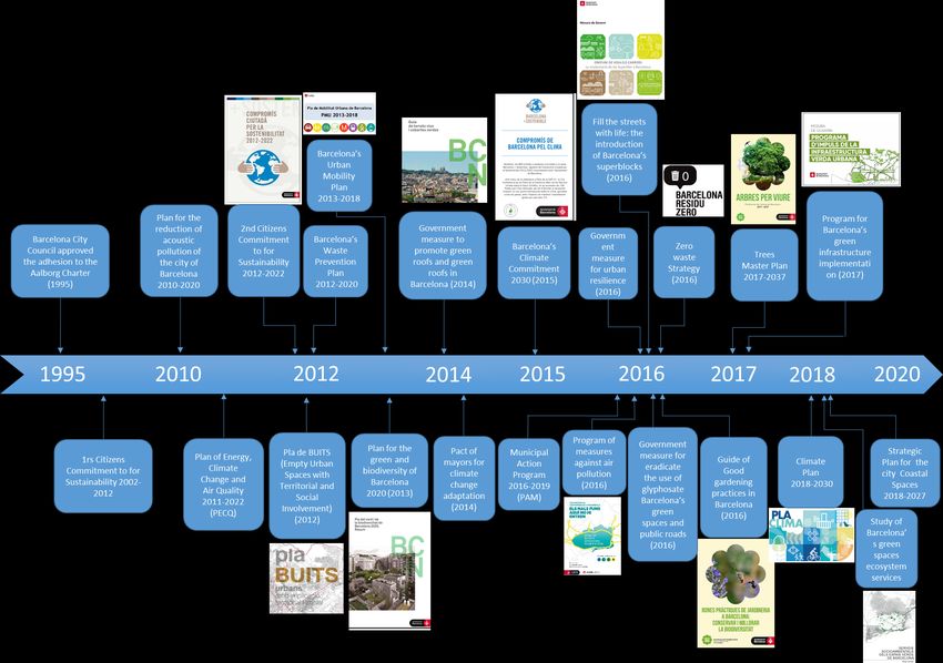
of air and noise pollution in the city are exceeding the thresholds set by current legislation and for
the World Health Organization (WHO) (Agència de Salut Pública, 2017) causing lots of health
issues and premature deaths aggravated with reduction of the Barcelona’s dwellers physical
activity (Mueller et al., 2016).

(Mueller et al., 2016) developed a model called Urban and TranspOrt Planning Health Impact
Assessment (UTOPHIA), the first health impact assessment (HIA) that quantifies the effects of
multiple urban and transport planning-related exposures in a city showing the considerable
impacts on inhabitants health. They estimate that 2,904 annually deaths in Barcelona could be
prevented (Mueller et al., 2016). The authors consider green spaces as “an important urban and
traffic management tool” (Mueller et al., 2016) for enhancing physical activity, for better citizens
mental health, to mitigate the harmful environmental exposures such as air pollution, noise and
heat.

To fight towards the negative impacts of urbanization is essential to renaturalize the city in
different ways and scales of intervention in order to increase the city resilience and enhance its
sustainability. For this reason, the green infrastructure is viewed, by many experts and
governmental entities, as a good opportunity to develop ecologically sustainable cities more liable
for the people that inhabit them. With this aim, the Barcelona city council would like to
renaturalize the city and transform its green areas to a well-connected network of green
infrastructure by the creation of green corridors as it is said in its Green and Biodiversity Strategy
“Pla del Verd i de la Biodiversitat de Barcelona 2020” and in its Green Infrastructure Action
Plan “Programa d’Impuls a la Infraestructura Verda Urbana (PIVU)” for increase 1.6 km2 of
urban green in order to improving citizens health and city resilience (Ajuntament de Barcelona,
2018b). One of the biggest projects of green infrastructure, of this action plan, that is taking place
now in Barcelona is the one in the area of Les Glòries that will introduce 100.000 m2 of green
surface in the city with the creation of a Les Glòries Park (Ajuntament de Barcelona, 2013). This
project was produced as a result of an agreement between the neighbourhood associations and the
Barcelona’s City Council called “Compromís per Glòries” where they establish the bases for Les
Glòries urban transformation and embedding citizen participation during all the planning process
and design.

The purpose of this master thesis is to:

    ●   Examine the green infrastructure strategic policy, planning and implementation in
        Barcelona.

    ●   Analyse citizen participation in Barcelona’s urban green policy and planning, and within
        the case study of Les Glòries Park.

In order to answer the following Research questions:

    ●   What are the problems and challenges of urban green planning and implementation in the
        city? There is more than one approach or opinion about it?

    ●   How citizen participation is embedded in green infrastructure policy, planning and
        implementation in Barcelona? And in Les Glòries?

                                                  4
The policies carried out by the City Council of Barcelona, although they have not been done with
citizen participation, have a strong commitment to improving the life quality of its citizens, as
well as facing climate change. Green infrastructure is being used in Barcelona as a strategic
planning tool for reducing car traffic and for increasing the green space available per inhabitant
in the city, providing ecological, social and public health benefits, in addition, to mitigate the
effects of climate change.

The case study of Les Glòries urban transformation shows that the urban green could be more
than an adaptation tool of climate change. The Glories Park will be the second largest green area
in the city, used as an urban glue for unify four neighbourhoods of the city, as well as being an
example of a paradigm shift in mobility based on pedestrians and public transport rather than
based on the car. This project should not have been the same without citizen participation and
without the great efforts made by neighbourhood associations together with the technicians of
Barcelona’s City Council. However, citizens had to be more interested and informed about what
is happening in the city.

In the following sections of this document, were explained the methodology used in this thesis
based on the review of literature, policy and planning document, web pages and news, as well as,
interviews and surveys analyses. In the third chapter of this document, the theoretical concepts of
urban green, green infrastructure and citizen participation were explained. In the fourth chapter,
was made a brief historical review of the city of Barcelona with a special focus on the case study
of Les Glòries urban transformation as an example of green infrastructure implementation in the
city. In the fifth chapter were compiled all the results obtained through the methodology. In the
sixth chapter, the results were discussed comparing with the theoretical concepts. And finally, in
the seventh chapter, the main conclusions of this thesis were stated in addition to possible future
work.

                                                5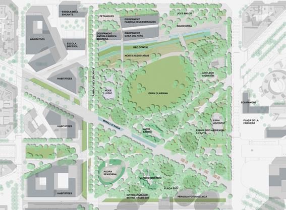
2. Methods
The methodology used for this thesis were, a review of literature, strategic policies and
action plans, document, web pages and news were made. After the analysis concerning
Barcelona's historical background and state of the art of its green infrastructure policy and
planning, by a case study approach. This information compilation was the base for
creating a questionnaire which was used to extract opinions, experiences and discourses
of different actors involved in green infrastructure policy and planning, and in the project
of Les Glòries Park by interviewing them. The information obtained in the interviews
also was used to complement and detail the case study explanation and some other
information about the review. In addition to interviews, the surveys made by the City
Council of Barcelona about the Project of Les Glòries square and its surroundings were
analysed in order to obtain the citizens opinions, points of view and worries about the
project of Les Glòries park. This surveys were the easiest way to get the most randomly
stratified sample possible with the highest number of population closer to Les Glòries. In
order to understand better the results of the survey, the experience of Les Glòries
viewpoint was used to collect information from its visitors about the project and to have
better understanding of the results analyzed in the survey.

2.1. Interviews
Different actors implied such as city council workers, architects, researchers and neighbourhood
associations, as we can see in Table 1, were interviewed for characterizing Barcelona’s urban
green, if there is more than one approach or opinion about the planning and implementation of
green infrastructure in the city, analyse the citizen participation in the city green infrastructure
policy and planning, and in Les Glòries park, in addition to complement the information obtained
from the review. All the interviewees answered the same questions about the green and Les
Glòries allowing to identify the different points of view and opinions for the same subject. The
content of the interviews is reported in the Results chapter and the questionnaire of the interview
could be seen in Appendices.

Table 1. People interviewed:

 External Actors                    City Council                 Neighbourhood Associations (AVV)

  BCNecologia          Àrea d'Ecología, Urbanisme i Mobilitat               AVV Poblenou
                        (Management of Les Glòries project)

 Cynthia Echave                     Rosa López                             Jaume Badenes

    29/4/2019                        24/4/2019                                 9/4/2019

Researcher ICTA        Àrea d'Ecologia, Urbana (Management            AVV Clot-Camp de l’Arpa
     (UAB)                  of Barcelona’s urban green)

  Francesc Baró                     Coloma Rull                            Miquel Catasús

     2/4/2019                        30/4/2019                                 9/4/2019

                                                   6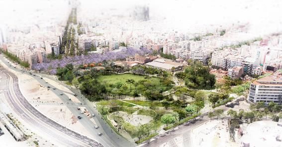
2.2. Surveys Analysis
The opinion of the citizens will be obtained from the last three surveys about the Project of Les
Glòries square and its surroundings, made by Barcelona’s City Council. Furthermore, the
experience of Les Glòries viewpoint will be an additional tool for the following analysis and
comprehension of the results of the survey.

2.2.1. Citizen’s opinions

From 2013, Barcelona’s City Council surveyed every year the inhabitants around the area of Les
Glòries to obtain information, about the citizen's problems, worries and opinion about the
neighbourhood public services and facilities, consumption and mobility habits, the project of Les
Glòries square and the impacts of its urban transformation. This survey is called Survey about the
Project of Les Glòries square and its surroundings. And for this thesis, were analysed the surveys
made in 2016, 2017 and 2018. For each survey were interviewed 670 people, older than 18 years,
from the seven neighbourhoods that surround the square. Through a stratified random sampling
with a confidence level of 95.5 % (Oficina Municipal de Dades (2016), Oficina Municipal de
Dades (2017) and Oficina Municipal de Dades (2018)). The tree surveys have almost the same
questions and it is possible to detect any change in the citizen's opinion and habits.

2.2.2. Citizens information

Les Glòries viewpoint was opened for the first time on the 12th of January and can be accessed
every first Saturday of the month, from 10:00 a.m. to 2:00 p.m., for free. This 6 meters high
viewpoint is located in the middle of the Les Glòries square, which allows showing to its visitants
how the works and the transformation of the area, enabling a global vision
of the space with the different main streets, la Meridiana, la Diagonal and
la Gran Vía. The viewpoint receives a great influx of citizens those
discusses the project, exchange thoughts and reflections with other visitors
while informers explain the project and answer the questions made by the
citizens.

  Figures 1 & 2. Experience from Les Glòries viewpoint on the 2nd of February 2019. (Own source).

                                                7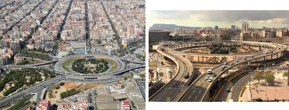
3. Theory
In the following section were explained the concepts of urban green and green infrastructure
focussing on the benefits and risks of green infrastructure implementation at the urban scale.
Furthermore, the social urban movements of neighbourhood associations and citizen participation
are explained according to the case study of this thesis, added to some guidance for citizen
participation processes in planning.

3.1. Urban green and Green Infrastructure (GI)
Barcelona’s City Council (Ajuntament de Barcelona, 2013, p. 9) defined urban green as the green
spaces (mostly parks and gardens) that are present in the urban fabric, which had been
incorporated to transform the urban space. When this greenery is linked with natural spaces or
farmland it became green infrastructure, working as a single ecological complex system offering
ecological, environmental, social and economic benefits. This tangible and intangible benefits
that people obtain from the ecosystem are called ecosystem services and are categorized by
(MEA, 2005) as provisioning, regulating, cultural, and supporting services. Although some of the
categories overlap, the supporting services are the most important because are essential for the
production of all other ecosystem services, also, differ from the rest because their impacts on
people are either indirect or occur over a very long time (MEA, 2005). Those ecosystem services
are enhanced by ecological connectivity between the natural environment and the semi-
transformed spaces that, in addition to the movement and dispersion of organisms, allow the
maintenance of ecological processes and the flows that characterize them (Ajuntament de
Barcelona, 2012).

The concept of Green Infrastructure (GI) was set for the first time in 1994 (Firehock, 2010), and
it has been defined by a wide variety of academics and organizations, but according to (European
Environmental Agency (EEA), 2011, p.6), the concept of green infrastructure has no single widely
recognized definition. However, most of the definitions agree that green infrastructure is a
multifunctional tool for landscape conservation through its connectivity, where green areas
became a network of functional spaces that its management provides a wide range of ecosystem
services, rather than isolated spaces preserved just for aesthetics.

Moreover, the definition of green infrastructure could also differ according to the scale where
green infrastructure is implemented providing different benefits (European Environmental
Agency (EEA), 2011). Green infrastructure at the urban scale is implemented for connecting parks
and other green spaces mostly for the peoples benefit, conversely, green infrastructure at the
landscape level (regional, national and transnational) is implemented for preserve and connect
natural areas to benefit biodiversity and fight against habitat fragmentation. Of course, that green
infrastructure at the landscape scale would also benefit people and green infrastructure at the
urban scale would be beneficial for habitat preservation, reducing landscape fragmentation and
enhance biodiversity. What is intended to explain is that green infrastructure is already a widely
used concept that could be applied at different scales and for different purposes that could provide
different benefits. In addition, the scale of green infrastructure implementation also predetermines
the typology and characteristics of the green infrastructure assets those can be man-made or more
natural/semi-natural (European Environmental Agency (EEA), 2011).

                                                 8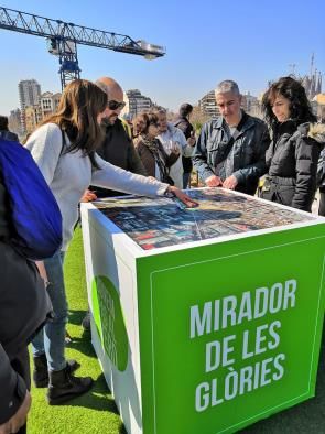
3.1.1. Green Infrastructure at landscape level

As humans, we depend on nature and biodiversity that supplies and provides us with lots of
benefits and drives our economy (European Commission, 2018b). Meanwhile, we are forcing the
earth system destroying natural ecosystems and putting under pressure they services. For this
reason the EU, in 2011, had developed the EU Biodiversity Strategy to 2020 that “aims to stop
the loss of biodiversity and ecosystem services” (European Comission, 2018a). The strategy is
based in 6 targets and 20 actions to achieve these objectives by 2020.

The EU Biodiversity Strategy is legally protected by EU nature legislation of the Birds Directive
and the Habitats Directive (European Commission, 2018b), those also creates the legal basis for
Natura 2000, the nature protection areas. In order to combat isolation between the Natura 2000
areas, was developed the EU Green Infrastructure Strategy with the purpose of connect this
areas through green infrastructure for restoring the ecosystems and its services while enabling the
species to live and migrate to different habitats (European Commission, 2018b).

The EU Green Infrastructure Strategy, was developed under the Target 2 of the EU Biodiversity
Strategy: “Maintain and restore ecosystems and their services” (European Commission, 2011),
that, “By 2020, ecosystems and their services are maintained and enhanced by establishing green
infrastructure and restoring at least 15 % of degraded ecosystems” (European Commission,
2011). This target 2 is broaden by 3 actions, those are improving the knowledge of ecosystems
and their services in the EU, setting priorities to restore and promote the use of green infrastructure
and ensuring no net loss of biodiversity and ecosystem services (European Commission, 2011).
Providing a common framework for Mapping and Assessment of Ecosystems and their
Services (MAES), for the restoration of ecosystems developing the Restoration Prioritization
Framework (RPF) and for Biodiversity-Proofing of the EU budget.
The EU Green Infrastructure Strategy aims to “promote the deployment of green infrastructure
in the EU in urban and rural areas” (European Commission, 2011) and is formulated as an
enabling framework that provides a combination of policy signals added to technical and scientific
actions that are implemented in the different existing legislations, policy instruments and funding
mechanisms (European Commission, 2013). This long-term EU commitment consist in: a) the
promotion of the Green Infrastructure in the main UE policy areas; b) improving the information
about Green Infrastructure, strength the knowledge base and promote its innovation; c) improving
the access to Green Infrastructure finance; and to d) extend the Green Infrastructure projects to
a EU-level (European Commission, 2013).

In conclusion, this strategy promotes the implementation of GI in all Europe and between Europe,
by the TEN-G network (European Commission, 2016a). The investment on green infrastructure
becomes an integral part of spatial planning and territorial development (European Commission,
2016b) being a connector between the different natural areas allowing the species movement
across them. It does not have its own legislation, but it has been integrated into the different
existing legislations in which the use of green infrastructure can be useful for its purpose. Using
the existing mechanisms that the policies provides (European Commission, 2013). By this way,
its application is intended to be more effective and produce a greater number of benefits in a wider
and more comprehensive range and fields (European Commission, 2016b).

The EU Biodiversity Strategy and the EU Green Infrastructure Strategy are made to enhance
green infrastructure initiatives at national level, but a framework for GI at local level is not broadly
developed yet (The Biodiversity Information System for Europe (BISE), 2015). The different
financial mechanisms and knowledge that the EU offers, are good opportunities for GI
implementation at national level, but these are not enough. More information must need to be
spread away to the population in order to force politician to change this situation, while, scientist
and researchers need to develop further the knowledge and the tools about green infrastructure,
for a better assessment of the ecosystems services that GI proportionate.

                                                   9
3.1.2. Green Infrastructure at urban scale
For the realization of this document, it is going to take as a reference to the definition of Green
infrastructure provided by the European Commission, also followed by Barcelona’s City Council:
“Green infrastructure is a strategically planned network of natural and semi-natural
areas with other environmental features designed and managed to deliver a wide range of
ecosystem services such as water purification, air quality, space for recreation and climate
mitigation and adaptation. This network of green (land) and blue (water) spaces can improve
environmental conditions and therefore citizens' health and quality of life. It also supports a green
economy, creates job opportunities and enhances biodiversity” (European Commission (EU),
2016a).
The city of Barcelona is the case study of this thesis, so this document it is going to be focussed
on green infrastructure implementation at the urban scale in order to connect parks and other city
green spaces manly for peoples benefit and enhance ecosystem services in the city. Next, were
shown the possible benefits and risks of the green infrastructure at an urban scale, according to
Barcelona's current context.
Benefits of green infrastructure at urban scale
The investment in green infrastructure at urban scale is seen by many authorities as a
successfully tested planning tool that provides environmental, economic and social benefits
through the development and use of natural-based solutions while it helps to reduce
dependence on 'grey' infrastructure that is usually more expensive to build and maintain
European Commission (EU) (2016a) and European Environmental Agency (EEA) (2011). The
green spaces must be understood as a multifunctional green infrastructure that, depending on
how green spaces are, can provide many potential benefits, both for health and for
environmental regulation.
In several studies carried out by ISGLOBAL, it has confirmed that green infrastructure is
beneficial for people’s health, since it promotes the practice of physical activity, reducing the
risk of cardiovascular disease and the prevention of obesity (Mueller et al., 2016). They have
also confirmed that being in contact with nature and green is beneficial for the cognitive level
of children, reducing stress with adults and for pregnant women (Triguero-Mas et al., 2015).
In addition, it has been scientifically confirmed that the presence of green provides
psychological benefits and improvements for humans, showing that green areas in hospitals
favour the recovery of patients who are in contact with the green (Chang et al., 2017).
Regarding environmental regulation, it has been shown that green and green infrastructure is
beneficial for microclimatic regulation (Wang, 2016) by reducing the island's heat effect. The
presence of plant mass allows the thermal balance of a microclimate to be much more
beneficial than not having a stone surface. It has also been shown that the presence of green
improves environmental quality, reducing levels of acoustic pollution (Wang et al., 2014) and
cushioning atmospheric pollution by capturing, retaining or at least decanting particles from
combustion. Due to the fact that cities have waterproofed most of the soil and urban green, the
increase in green infrastructure allows to give the opportunity to breathe the soil by returning
its permeability to retain water, control run-off and control the rainfall of the city. The impact
of the green infrastructure on the water cycle also allows the green to act as a mitigation of
climate change (Wang, 2016).
10The implementation of green infrastructure at council level reinforce the character of the areas
where they are located, improving its connectivity and cohesion with the rest of green spaces,
minimizing its fragmentation meanwhile increasing biodiversity, working for a more ecologic
coherence and nature preservation (Ribeiro and Barao, 2006, in Calaza-Martínez, 2016),
allowing the creation of synergies and benefits to higher level than the local one (Davies et
al., 2006, konijnendijk et al., 2004, in Calaza-Martínez, 2016).
Potential risks of green infrastructure at urban scale
Green infrastructure also has negative aspects such as allergic reactions to pollen, a feeling of
insecurity in green spaces in some cases, or can damage urban infrastructure for example when
a branch falls, but these are minor issues.
Gentrification is a process that takes place in a neighbourhood or in an area where is been
elitizing, the first symptom is the change of the commercial fabric for one with more select
products, showing that the purchasing power of its residents is raising, then the rental price
also increases. Finally, gentrification can end up with a process of expelling neighbours with
less purchasing power.
Sometimes green is used as an attractor of high-income people that are looking for a healthy
environment to live. Green gentrification takes place when the creation of a green area is used
as a tool for favouring gentrification (BCNUEJ, 2019). In addition, many cases of green
gentrification were studied in North America showing that green gentrification is also a matter
of environmental justice showing that green areas only benefit the health of privileged
residents living in neighbourhoods that are been gentrified, excluding the most disadvantaged
social classes (Cole, 2019). So the amenities and the environmental hazards are being
disproportionately distributed (BCNUEJ, 2019), being the low-income people the ones that
are more vulnerable to the lack of green spaces.
The Green LULUS group, led by the researcher Isabelle Anguelovski, studies the social
impact by the creation of green spaces and urban parks. Anguelovski et al., (2017) had
published a study that measured different gentrification indicators for 18 parks that were
created in Barcelona from the 90’s in order to know if the creation of municipal green spaces
in Barcelona have contributed to green gentrification or, conversely, has dealt with social or
racial inequalities by an environmental justice point of view. The results indicate that new
parks in the old town and in the new urbanized neighbourhoods show the possibility of having
experienced green gentrification (Anguelovski et al., 2017). Instead, the most low-income
areas that are far from the city centre had gained residents as these areas became greener,
indicating a possible concentration of vulnerable residents in these areas of the city
(Anguelovski et al., 2017). Beyond the creation of these parks, there had been a very important
urban transformation in these neighbourhoods. So the paper concludes that green
gentrification is a complex issue, which can not only be attributed to the green space itself but
is linked to a wider urban transformation process.
A lot of research has been done about how badly managed urban environmental strategies
could potentiate gentrification were its main effects are suffered from the most economically
vulnerable population (BCNUEJ, 2019).
113.2. Social urban movements and Citizen Participation
Social movements are a group of people from different ideology and social stratus united by a
common interest. These arise when they consider that institutions, normally pressured by
economic factors, do not carry out correct management of collective heritage. The concept of
collective heritage is very generic and this can be considered of many types. But it can be defined
as everything that the population considers as their own and that has a high value or importance
for itself and its environment (Nel·lo, 2015). Social movements generally arise in cities due to a
greater population density and social awareness, where the use of collective heritage generates
more concerns and is more dependent on economic activities, becoming social urban movements.
The social urban movements, arise in Barcelona since the process of industrialization of the city
in the nineteenth century, as a result of a set of economic, demographic and social changes.
According to Nel·lo (2015), the social movements in Barcelona, from the early sixties to the
present, can be grouped into; a) Neighbourhood Movements, b) Movements in Defence of the
Territory and the Environment, and c) Movements of Social Innovation. Due to political, urban
and social changes happened in Barcelona. According to Nel·lo (2015), there was a progressive
displacement of the focus mobilizations, from the questions related to the defence of the territory
towards social and political issues. Although, the focus displacement of social urban movements,
these have been happening over the years depending on the motivations of these movements
without implying the substitution of one problem for the other (Nel·lo, 2015).
3.2.1. Neighborhood Associations
Neighbourhood movements in Barcelona arose from the last years of Franco dictatorship until the
first years of municipal democracy from 1959 to 1979, due to the struggle over land uses, the
management of natural resources and place attachment (Nel·lo, 2015). Neighbourhood
associations were developed as a result of neighbourhood movements, these are defined by the
“Federació d'Associacions de Veïns i Veïnes de Barcelona (FAVB)” (Federation of
Neighborhood Associations of Barcelona) as: “Non-profit organization constituted by citizens of
the neighborhoods who seek for quality solutions to collective problems and act in formulating
demands for the rights to welfare and quality of life, making them participate in all stages of the
Project to a large number of people, struggling for self-organization of society and taking into
account as priority objectives:
● Improve the quality of life of the neighbourhood
● Organize and defend collective interests
● Foster neighbourhood relations
● Promote the collective memory to give the neighbourhood the identity” (FAVB, n.d)
During the local and regional institutions consolidation from 1979 to 2007, there was a reduction
of neighbourhood conflict in the eighties due to the institutionalization of part of the demands of
social urban movements since the advent of democratic administrations (Nel·lo, 2015). Since
then, neighbourhood associations became the main channel between the citizens and the City
Council. The citizens when they have a complaint or a problem in their day to day they inform to
their neighbourhood associations and the neighbourhood associations to the city council. The
information is given to the neighbourhood associations and then is explained to the citizens when
we carry out the neighbourhood assemblies where there is an exchange of information that is
beneficial for both parties. Citizenship delegates to neighbourhood associations since they have
more power than a neighbour itself.
123.2.2. Citizen participation
With the situation of an economic, social and political crisis from 2007 to 2015, has raised a set
of new citizen and social practices with the aim of confronting the material consequences of the
crisis on the population, while trying to empower local communities and promote alternatives for
social organizations (Nel·lo, 2015). On many occasions, the impulse of these initiatives is
accompanied by political demands for quality decision-making processes, the demand for citizen
participation and the defence of social rights. These practices have often been grouped under the
concept of “social innovations” (Nel·lo, 2015).
According to Arnstein (1969), “Citizen Participation is a categorical term for citizen power”.
Informing citizens should be the most important first step for citizen participation legitimation.
However, if the flow of information is just from officials to citizens without any feedback, this is
nor citizen participation. The same happens with consultation, inviting citizens' opinions, can be
a legitimate step toward their full participation. But if consultation is not combined with other
modes of participation, it is not citizen participation unless citizen concerns and ideas will not be
taken into account (Arnstein, 1969). Citizen participation happens when there is an exchange of
information from municipal technicians to citizens as well as from the citizens to municipal
technicians, apart from citizens having the power to negotiate with the city council. Citizen
participation has to take place from the first stages of planning, otherwise, citizens have little
opportunity to influence (Arnstein, 1969).
There are three ways of citizen power depending on its influence degree on decision-making
(Arnstein, 1969). These are a) Partnership; when citizens are engaged in the process and can
negotiate with the city council by policy boards and planning committees, meanwhile, the
planning and decision-making responsibilities are shared between the citizens and the city council
b) Delegated power, when in negotiations between citizens and the city council the citizens are
the main decision-makers over a particular plan or program, and c) Citizen Control; when citizens
have the full power to decide, but there are just a few examples of it (Arnstein, 1969).
3.2.3. Citizen participation in planning
The City Council of Barcelona is aware that democracy is more than go to vote once every four
years. And that citizens must take part in political decisions by citizen participation processes.
Participatory processes are defined by Barcelona’s City Council as: “A series of meetings
delimited at a specific time to promote the debate and the contrast of arguments between citizens,
or between them and those responsible for municipalities. A participatory process can deal with
almost any topic and may affect one or more neighbourhoods and districts or the entire city”
(Decidim Barcelona, 2017).
In October 2017, Barcelona’s City Council approved a new Regulation for citizen participation
as a result of a participative process between various municipal groups, neighbourhood
associations, participation bodies and citizenship. This framework defines the political
participation channels; the necessary resources to carry it out and a system that must ensure the
good use and efficiency of these channels. “The current Regulation represents a strong impetus
for the citizen initiative that fosters channels of direct democracy, commitment to hybrid
participation between the digital and face-to-face world, which favours transparency and
traceability and puts special attention in guaranteeing inclusive participation that takes into
account the diversity and needs of the entire population of Barcelona” (Decidim Barcelona,
2017).
13The City Council of Barcelona conceives citizen participation as a partnership, previously
described by Arnstein (1969). Where citizen participation takes place as a genuine interchange
between citizens and city planners wherein municipal technicians have to be open to working
with citizens, while, citizens must be active and competent in planning. According to this last
definition, Godschalk (1971) calls this type of citizen participation as “Collaborative planning”.
Godschalk (1971) in Fagence (1977) were established twelve propositions that must be taken into
account during citizen participation in planning. The following propositions have been classified
according to whether citizen participation relies on policy and planning or in local planning:
Citizen participation in policy and planning
● “The broader the base of citizen participation in the planning process, the more potential
influence the planner and citizens can bring to bear on public policies and plans”.
● “The broader the base of citizen participation, the more potential influence the planner
can bring to bear on the social choices of the citizens, and vice versa”.
● “The more diverse the interest represented in the planning process, the more innovative
will be the proposals”.
● “The more decentralised the client groups, the more innovation will be adopted,
conversely, the more centralised and comprehensive the decision process, the fewer will
be the innovations”.
● “The more the planning process facilitates citizen participation, the more the community
will be aware of the planning function as a democratic and community force”.
● “Participatory planning, open to radical proposals, is more likely to pursue innovative
solutions to community problems”.
● “The wider the scope of planning and the longer the time horizon, the less useful (and
possible) collaborative planning will be” (Godschalk, 1971 in Fagence, 1977).
Citizen participation in local planning
● “Local planning goals will be more congruent with community desires if discussed widely
by participant groups and then communicated to the decision-making body”.
● “A one-way flow of objectives from a central decision-making body to a planning agency
will tend to under-represent the interest of some community groups”.
● “The more public consultation techniques are used, the more the planning programme
will attract public support”.
● “The relevance of the planning function and its influence will depend upon the number
of dispersed contacts established in the community” (Godschalk, 1971 in Fagence, 1977).
144. Case study: Les Glòries in Barcelona city
In this chapter, the historical background and the urban transformations that have happened in the
city of Barcelona and in the area of Les Glòries are going to be explained in order to understand
the importance of this project.
4.1. Brief historical review of Barcelona’s Urban Transition and
Transformation
At the end of the eighteenth century, the wall that surrounded the city became an urban problem
due to the increase in population density and several epidemic outbreaks. This situation forced
the local government to consider a plan for expanding Barcelona that could provide more space
for a growing population that demanded a better water supply and sewer system (Aibar & Bijker,
1997). Between 1854 and 1868 the Barcelona’s walls were demolished and the planning proposal
of the Catalan civil engineer Ildefons Cerdà was the one imposed by the Spanish Government to
expand the city of Barcelona.
One of the main influences in the development of the Cerdàs Plan was the 19th hygienist theories.
He identified that many of the deaths occurring in Barcelona were produced as a consequence of
the city urban form. His initial plan, presented in 1856, planned the city space as a grid of blocks
with an extension of 113.3 by 113.3 m2 surrounded by 35 meter wide streets or big avenues from
50 to 80 m wide, those allow natural sunlight, wind and big green areas in order to optimize the
living standards. Cerdà also predicted the future development of a transportation system, this is
the reason why the corners of every block were cut out as a chamfer for having better visibility
and favouring the vehicles to turn easier. The streets were divided into two equal parts, one for
vehicles and one for pedestrians (Aibar & Bijker, 1997). However, the original plan was modified
in 1859 to accomplish with the local government demands. Cerdà diminishes the wide of the
streets from 35 to 20-30 m, the depth of buildings was extended to 20 m tall, and the former
regular distribution of parks and gardens, which supposed to be the 50 % of the total block surface,
was not made obligatory (Aibar & Bijker, 1997).
Figure 3. Barcelona’s map of the Cerdàs Plan. (Arxiu Històric de la Ciutat de Barcelona, n.d)
15The final Cerdà’s plan, that allowed people to walk through its wide streets and rest in parks and
gardens, was not carried out due to the increasingly high population growth, housing speculation
and the introduction of the private vehicles. The Cerdàs building laws were mostly broken, the
buildings were built in all the block sides occupying more than 80 % of the block surface while
the streets became highly dominated by car traffic and occupied by parking lots, reducing the
public space for the pedestrians. The priority given to the car in the coming years was coupled
with the urbanization of the periphery to place the immigrants arrived from other parts of Spain,
during the years 1945 and 1975, that led to an accelerated process of land occupation, repeated in
1986. The rapid development caused a lack of open spaces, infrastructures, social services and
public transportation for the periphery. As a result of all of these processes, Barcelona has become
a very compact city dominated by cars and with few green areas.
Figure 4. The gradual occupation of Cerdà’s blocks (Dintorni Barcellona, 2013)
164.2. Introducing the area of Les Glòries
The area that today occupies the current Plaza de Les Glòries Catalanes has always been a place
of passage rather than a stopover, as a natural way out of Barcelona (Ajuntament de Barcelona,
2014a). In the tenth century, the construction of the Rec Comtal, an irrigation canal near
Barcelona, changed the physiognomy of the place transforming it into a large fertile plain of crops.
The area remained almost unchanged until the 18th century when the Bourbonic troops settled in
this place to bombard the city during the siege of Barcelona in 1713-1714. Once the war was won,
the area was abandoned, becoming an empty urban space, a characteristic that has marked this
place since then (Ajuntament de Barcelona, 2014a).
In the mid-nineteenth century, while the walls of the city were being demolished, several rail and
tram lines were built across the area that hampered the development of the Cerdà’s Plan for the
reform and expansion of Barcelona. Cerdà imagined the Les Glòries as the future city centre
where the crossing of the Gran Vía, the Meridiana and the Diagonal took place. The train tracks
obliged the engineer to modify the orthogonal mesh of his plan where the square becomes a large
rectangular hole of 9 hectares, turned 30 degrees with respect to the Gran Vía. This exception in
the regularity of the Cerdà scheme gives an idea of the difficulties that this area of the city has
always entailed (Ajuntament de Barcelona, 2014a).
At the beginning of the 20th century, many city planners and architects made several urban
planning proposals that were never carried out due to the complexity of the area, its poor
communication and the presence of the railway. Becoming an empty degraded space in the
outskirts, lacking in all order and crossed by the train tracks (Ajuntament de Barcelona, 2014a).
In 1928 it was decided to move the Fira de Bellcaire also called “Els Encants”, which became a
singularity of the square, along with industries and many railroads. The lack of urbanization of
the area made Glories an insecure space that favours clandestine activities and crime.
Between the decades of the 30’s and the 50’s, the rail tracks were buried, propitiating the first
major formal urban transformation of the area. At the end of the 60’s, the city was totally rendered
to the automobile. The area of Les Glòries was crossed by the Gran Vía connecting with the
highway of Mataró, becoming the main road junction of the city. During the decade of the 70’s,
the car traffic continued to increase and the square presented a complex set of roads, ramps,
overpasses and underground tunnels with a public park, equipped with a children's play area and
an artificial stream in its surroundings. In the decade of the 90’s, due to the celebration of the
Barcelona 1992 Olympic Games, the old roads were substituted by a double ring that housed a
parking lot and inside the ring was located a park with 2.10 hectares (Ajuntament de Barcelona,
2014a). The neighbourhood associations of the area were against the project as this allows a
motorway in Les Glòries perpetuating high-density car traffic. The associations were mobilized
but they do not enough support from the citizens due to the great transformations that were taking
place in the city. On the other hand, the mobilizations were able to put traffic lights to stop the
freeway and eliminate the elevated steps to facilitate the connection between the neighbourhoods
that surrounded the ring.
17Figures 5. Aerial picture of Barcelona where it could be seen the ring of Les Glòries square (red circle),
in the middle east of this picture. Picture modified from (Centre Europeu Bcn, 2019).
Figures 6 & 7. Pictures of the past double ring hosted in Les Glòries square.
(EjePrime, 2018) and (Ajuntament de Barcelona, 2014d).
However, the ring allowed the extension of the Diagonal to the sea and the subsequent
transformation of the 22@ district. These urban transformations required the definition of a new
urban project for the area of Les Glories that started with the opening in 1995 of the Glòries
Shopping Center and the La Farinera del Clot Cultural Center or the construction of the La Torre
Agbar (1999-2005) among others. “The project of the ring was a failed attempt to integrate a
road solution with green public space” (Neighbourhood Associations). The landscape of this area
of the city, which had not yet really become a square, was totally hostile for the pedestrians and
had been completely dominated by the car (Ajuntament de Barcelona, 2014). The double ring was
a barrier between the surrounding neighbourhoods of Clot-Camp de l’Arpa, Poblenou, Fort Pienc
and Sagrada Família, as it could be seen in Figure 8. Moreover, the inner park of the ring did not
have any utility.
18Figure 8. Aerial picture of Barcelona where it could be seen how the ring of Les Glòries square, was a
barrier between the surrounding neighbourhoods of Clot-Camp de l’Arpa (yellow), Poblenou (orange),
Fort Pienc (red) and Sagrada Família (pink). Picture modified from (Prat, 2014).
As a result of the issues produced by the double ring, as well as, the irregular situation of the
Encants and some housing. There was a strong citizen claim for changing this situation. The City
Council of Barcelona wrote, in 1999, a modification of the General Plan of Barcelona that
perpetuates the road ring and more housing in return of building public facilities and green areas
(Ajuntament de Barcelona, 2017b, p.11) that were not made (Ajuntament de Barcelona, 2007,
p.2). This proposal of 1999 was not accepted by the neighbours who demanded a deep rethinking
of the area in addition to its participation in the urban planning and design of the space. The city
council did not meet the demands of citizens and the associations were continued to mobilize.
The area of Les Glòries stayed more than 150 years almost as an empty urban space although was
planned by Cerdà as a new urban centrality where takes place the crossroad of the three main
roads of the city. Despite its potential, the area reminded as an urban gap until the arrival of the
car. Since then, the area of Les Glòries has been transformed into a point of access and exit from
the city. Today, this area can no longer assume the role of city urban gate because the city has
extended much further (Ajuntament de Barcelona, 2017b, p.12)
195. Development and analysis of results
In this chapter, has been made a revision of Barcelona’s municipal planning. Then, the policies
and plans related to Barcelona’s urban green those are the Green and Biodiversity strategy called
“Pla del Verd i de la Biodiversitat de Barcelona 2020” and the Green Infrastructure action plan
called “Programa d’Impuls a la Infraestructura Verda Urbana (PIVU)” have been described
and evaluated through the answers obtained by the interviews made.
In addition, the case study of Les Glòries urban transformation, previously introduced, is going
to be explained in detail about the chronology of all the citizen participative processes, the agents
involved and an explanation of the final layout of Les Glòries Park. Then, this project is going to
be evaluated through the answers obtained by the interviewees and by the surveys.
5.1. Revision of urban sustainability policies in Barcelona
In order to have a more resilient city for the future challenges of global change and achieve long-
term sustainability, it is necessary a paradigm shift on city planning, with a multidimensional
approach interrelated with the different areas such as transport, waste management, water
management, pollution, health, urban green, biodiversity, education, culture and economy among
others. Besides to include the actor's interests and involve the citizens in urban planning. The City
Council of Barcelona has been implementing these criteria since its adhesion to the Aalborg
Charter in 1995, defining its local agenda 21 through the Citizen Commitments for Sustainability
(2002-2012) and (2012-2022) (Ajuntament de Barcelona, 2015). These documents were the basis
of the work carried out by Barcelona’s municipality in the field of biodiversity with
renaturalization as the priority of its local sustainability strategy.
Next, a timeline, Figure 9, is presented with a revision of the different municipal policies, plans
and action plans developed in the last decade by the City Council of Barcelona in order to combat
climate change, with a special focus on those that are going to be explained in this chapter, related
to city renaturalization and to green infrastructure implementation.
20You can also read