Mitigation Action Plan - City of Canyon and Canyon ISD - DEVELOPED BY THE CANYON HAZARD MITIGATION ACTION TEAM - City of Canyon ...
←
→
Page content transcription
If your browser does not render page correctly, please read the page content below
Canyon
Mitigation Action Plan

                      City of Canyon and Canyon ISD

                             DEVELOPED BY THE CANYON
                        HAZARD MITIGATION ACTION TEAM
                                 JANUARY 2021

City of Canyon Hazard Mitigation Plan 2021              Page 1
Record of Changes

        Change Number                   Date of Change   Initials and Date Entered

City of Canyon Hazard Mitigation Plan 2021                                     Page 2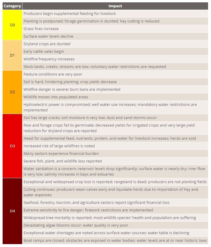
RECORD OF CHANGES                                                      2

OVERVIEW AND DEMOGRAPHICS OVERVIEW:                                    4

DOCUMENT ORGANIZATION                                                  4

ELEMENT A - PLANNING PROCESS                                           6

PLAN PREPARATION (A1)                                                  6
PLANNING PROCESS                                                       7
ESTABLISHING THE MITIGATION ACTION TEAM (A2)                           8
ESTABLISHING AN OPEN PUBLIC PROCESS (A3)                              13
EXISTING DOCUMENT REVIEWED FOR PLAN DEVELOPMENT (A4)                  14
CONTINUED PUBLIC PARTICIPATION PROCESS (A5)                           15
MONITORING (A6)                                                       15
ELEMENT B – HAZARD IDENTIFICATION AND RISK ASSESSMENT                 18

NATURAL HAZARD PROFILE (B1, B2, B3)                                   20
DROUGHT                                                               20
FLOODING                                                              24
HAIL                                                                  27
LIGHTNING                                                             30
TORNADO                                                               32
WILDFIRE                                                              35
WINDSTORMS                                                            38
WINTER STORM                                                          41
NFIP INSURED STRUCTURES AND SEVERE REPETITIVE LOSS (B4):              45
ELEMENT C – MITIGATION STRATEGY                                       46

EXISTING AUTHORITIES, POLICIES, PROGRAMS AND RESOURCES (C1):          46
NATIONAL FLOOD INSURANCE PROGRAM (NFIP) (C2)                          47
GOALS TO REDUCE/AVOID LONG –TERM VULNERABILITIES (C3)                 48
MITIGATION ACTION ITEMS (C4/5)                                        50
INTEGRATING MITIGATION PLAN IN TO OTHER PLANNING MECHANISMS (C6)      61
MITIGATION ACTIONS 2015                                               64
ELEMENT D – PLAN REVIEW, EVALUATION AND IMPLEMENTATION                62

DEVELOPMENT TRENDS                                                    62
ELEMENT E – PLAN ADOPTION (E1)                                        67
CITY OF CANYON CITY COMMISSIONERS ADOPTION                            68

City of Canyon Hazard Mitigation Plan 2021                         Page 3
Overview and Demographics Overview

CITY OF CANYON, TEXAS. The City of Canyon lies at
the junction of U.S. Highway 60 and Interstate Highway 27,
near the center of Randall County. Incorporated in 1906,
Canyon is a residential community located approximately 15
miles south of the City of Amarillo and 12 miles west of the
Palo Duro Canyon (from whence the City takes its name).
Canyon serves as the County Seat of Randall County.

Canyon is located in a valley that runs to the east and
eventually becomes Palo Duro Canyon, the second longest
canyon system in the US (second only to the Grand Canyon)
and is a major tourist attraction.

By 1987, the City of Canyon had three public schools, two city parks, a hospital and nursing center, a
radio station, a new county library and city hall, and new county government facilities. The population
was 5,864 in 1960, 10,724 in 1980, and 12,875 in 2000.

Document Organization

Provided below is brief explanation on the lay-out and content of this document. The sections included in
this plan are:

Adoption
This plan was formally adopted by the City of Canyon after the document had been reviewed by both the
Texas Division of Emergency Management (TDEM) and the Federal Emergency Management Agency
(FEMA) to ensure it met current state and federal guidelines governing local HMPs.

Authorities
This section provides a description of the legal authorities under which this plan was developed.

Purpose
This section explains why the plan was written and identifies the benefits to the participating jurisdiction
of having a current Hazard Mitigation Plan.

Element A – The Planning Process
This section explains how the plan was organized and the process followed in developing this document,
including:
•   Establishing the Mitigation Action Team: Identifies the process the jurisdiction followed in
    establishing their mitigation action team.
•   Establishing an Open Public Process: Identifies MAT took to encourage public participation during the
    development of this plan.

City of Canyon Hazard Mitigation Plan 2021                                                          Page 4
Element B– Hazard Identification and Risk Assessment
This section identifies and analyzes the hazards that affect the jurisdiction and their impact.
Hazards – Describes the hazards that impact jurisdiction.
History of Local Hazards – Provides historical and statistical data related to the specific hazards that have
impacted the jurisdiction.
Risk Summary – Community priorities on specific hazards.
Vulnerability Worksheets – Provides a graphical representation of the jurisdiction’s vulnerability to the
identified hazards.
Loss Estimates – Provides an estimate of the impact each hazard would have on the critical infrastructure
located within the jurisdiction.
Past Mitigation – Provides a summary view of previous mitigation efforts undertaken by the jurisdiction.
Development Trends – Provides an analysis of a growth trends within the jurisdiction which were
considered in developing the mitigation strategies discussed in Element C.
Element C– Mitigation Strategies
Mitigation Goals and Objectives – Provides the framework for the development of the long-term and
short-term strategies identified with the Mitigation Actions.
Mitigation Actions – Describes the actions that each participating jurisdictions proposes to undertake
in order to mitigate the impact of future hazard events.
Element D – Plan Review, Evaluation and Implementation
Utilizing development patterns and new hazard or risk information; jurisdictions will evaluate
progress on the action items and make changes based on new findings.
Jurisdiction will resubmit plan for approval within 5 years.
Element E– Plan Adoption
Plans will be adopted by the jurisdiction through its appropriate governing body. This adoption takes
place after plan draft has been approved by state and FEMA for applicable content
City of Canyon Hazard Mitigation Plan 2021 Page 5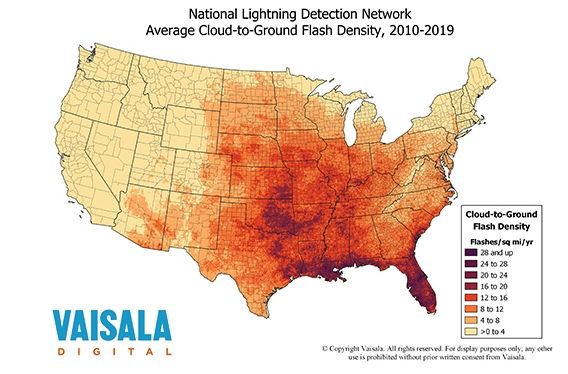
Element A - Planning Process

Plan Preparation (A1)
The Hazard Mitigation Plan was developed through the active participation of representatives of the City
of Canyon and Canyon ISD. Through their expertise in emergency management, engineering,
administrative, public works, building and road maintenance, their contributions were critical in the plan
development. The team also included stakeholders such as: local business owners, industry
representatives, neighboring jurisdictions, regional and state partners. The list of mitigation team
members is located on page 12.

This graphic below illustrates the steps taken by the Canyon MAT in developing this document.

Overview of City of Canyon Planning Process
             ORGANIZED ASSETS: Identified and established relationship with existing mitigation
             authorities and encouraged an open public process that extended to:
              a. MAT Members
              b. Interested residents from the MAT’s participating jurisdictions
              c. Interested Private/Non-Profit plan stakeholders

             DEVELOPED THE PLAN: Develop the HMP based on the risk assessment by:
              1. Creating goals and objectives.
              2. Developing mitigation action items and prioritizing these actions.
              3. Preparing an implementation and monitoring strategy.
              4. Documenting the mitigation planning process.

            IMPLEMENT PLAN/MONITOR PROGRESS: To promote goal attainment and/or to make
            adjustments as needed during the HMP’s 5-Year life

             ASSESSED RISKS: Conduct risk assessment by answering the following questions:
              1. What types of hazards is Canyon vulnerable to?
              2. How bad can these hazards get?
              3. What’s being impacted by the identified hazards?
              4. How will assets in Palisade’s area be impacted by the identified hazards?

City of Canyon Hazard Mitigation Plan 2021                                                        Page 6
Planning Process
    Date                 Activity Description                           Invitee/Attendees
                                                            Danny Cornelius (Dir. Planning and Dev.)
                                                                  Dan Reese (Public Works Dir.)
   3/7/2019      Hazard Mitigation Planning Meeting                  Mike Webb (Fire Chief)
                                                                Jon Behrens (Asst. City Manager)
                                                                   Ray Resendez (PD Captain)
                                                                      Invited and attended:
                                                                Jon Behrens (Asst. City Manager)
                                                                    Dennis Gwyn (Fire Chief)
                                                            Danny Cornelius (Dir. Planning and Dev.)
                                                            Robyn Cranmer (Asst. Sup. Canyon ISD)
                                                               Dan Reese (Director Public Works)
                                                                    Steve Brush (Police Chief)
                                                                 Mike Gittinger (NWS Amarillo)
                                                                   Invited but did not attend:
  1/28/2021        Hazard Mitigation Action Meeting              Gretchen Mercer (City Secretary)
                                                                     Joe Price (City Manager)
                                                                       Mayor Gary Hinders
                                                                Chip Orton (Amarillo Area OEM)
                                                              Dean Turney (Hereford Fire Marshal)
                                                                     Shawn Burns (WTAMU)
                                                                    Richard Smith (WTAMU)
                                                            Jeff Davis (Palo Duro Canyon State Park)
                                                                  JD Ragland (Extension Agent)
                                                             Ashley Johnson (Texas Forest Service)

  Meetings were posted 72 hour in advanced at City Hall. Invitations were sent out via email. The public
 was invited to attend through the Canyon message alert system. Sign-in sheets were utilized and agendas
                                     were available at each meeting.

City of Canyon Hazard Mitigation Plan 2021                                                      Page 7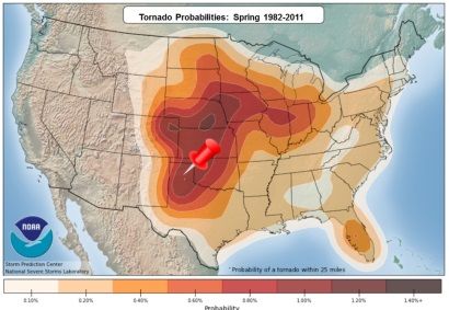
Establishing the Mitigation Action Team (A2)

The original Canyon Hazard Mitigation Plan was approved in 2006 and subsequently updated and
submitted to FEMA in March of 2016. In April of 2019, the mitigation team chairman began the process
of updating the plan. This process included reviewing mitigation strategies that would be appropriate for
the City and defining it’s vulnerabilities. On this update the City reached out to Canyon Independent
School District to participate in this update.

Mitigation Action Team Hierarchy

                                                   Plan Author
                                                      PRPC

                                  Planning Team: Direct Representatives

              Participant             Participant             Participant            Participant

At the outset of the planning process, the HMT chairman and Plan Author emailed a solicitation to the
other jurisdictions and plan stakeholder groups in the City and ISD; inviting their participation on the Canyon
Mitigation Action Team (MAT). In addition, the MAT meetings were all well-advertised and the meeting
postings encouraged and welcomed the public’s participation.

Overall, the list of agencies / organizations thought to have a direct stake or interest in this HMP update
process or that could somehow inform the planning process included:

City of Canyon Hazard Mitigation Plan 2021                                                             Page 8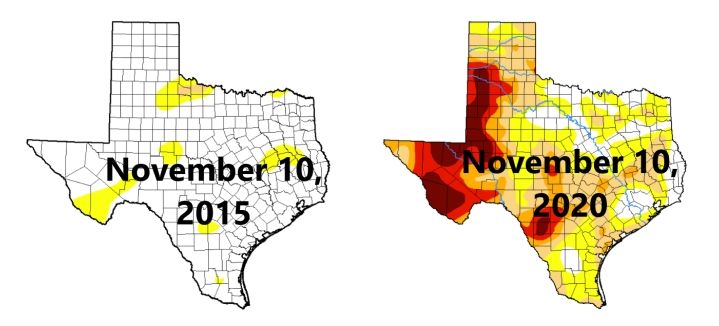
Mitigation Action Team – Participating Jurisdictions
                                             Mitigation Action Team Members
                  Agency and Position                  Potential Stake, Interest or Contribution
                                                       City Officials would have a stake in any mitigation actions
                  Elected Officials
                                                       undertaken by the City and would ultimately be responsible for
                  Mayor
                                                       recommending the update’s adoption by the City Commissioners

                                                       City Administration would have a stake in any mitigation actions
                  City Administration
                                                       undertaken by the City and would ultimately be responsible for
                  City Secretary/Manager
                                                       recommending the update’s adoption by the City Commissioners
 City of Canyon

                  Public Works                         Could provide detail on how hazards and proposed mitigation actions
                  Public Works Director                could impact the City’s utility systems
                  Police Department                    The Department could both inform and have a direct interest in the
                  Police Chief                         HMP’s mitigation measures
                  Fire Department                      The Department could both inform and have a direct interest in the
                  Fire Chief                           HMP’s mitigation measures, particularly those that apply to wildfires

                  Office of Emergency Mgmt.            The OEM could provide mitigation ideas and presumably, would be
                  EMC                                  charged with carrying a number of the mitigation actions out

                                                       Being located in the planning area, the ISD campuses would share
                  Canyon ISD
                                                       the area’s hazard concerns and could be benefited by the MAT’s
                  Assistant Superintendent
                                                       mitigation actions

City of Canyon Hazard Mitigation Plan 2021                                                                       Page 9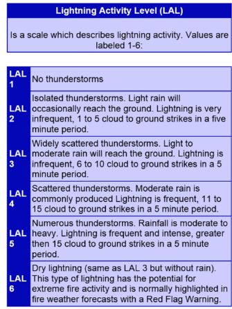
Stakeholders
                                        Agency and Position               Potential Stake, Interest or Contribution
                                        Texas AgriLife Extension          AgriLife could inform some of the decisions that might impact
                                        Randall County                    area farmers/ranchers and help in promoting certain mitigation
                                        Extension Agent                   actions.
   Local Partners

                                                                          The residents of the planning area would have a direct stake
                                        THE PUBLIC
                                                                          and interest in the outcome of this planning process
                                                                          Jurisdictions that border the planning area have an interest in
                                        Neighboring Communities           the outcome of this planning process and could contribute to
                                                                          the development of hazard profiling.
                                        Panhandle Regional Planning       Aside from assisting the MAT in writing this update, PRPC
                                        Commission (PRPC)                 could provide data that would inform the actions/decisions of
                                        Regional Serv. Director           the MAT
                                        Amarillo Office of the National
                                                                          The NWS could provide regionalized data with regard to
                                        Weather Service (NWS)
                                                                          past/forecasted weather trends that could inform the formation
                                        Warning Coordinator
                                                                          of mitigation actions
   Regional, State & Federal Partners

                                        Meteorologist
                                        Texas Forest Service (TFS)        TFS resources could inform the MAT’s development of
                                        Regional Fire Coord.              wildfire mitigation actions
                                        National Parks Service            PDC resources could inform the MAT’s development of
                                        Palo Duro Canyon Director         flooding mitigation actions
                                        Army Corps of Engineers (ACE)     ACE resources could inform local flood control efforts with
                                        SW Div.,Fort Worth, TX            streambed/wetland data
                                        Texas State Data Center (TSDC)    TSDC resources could provide data to forecast future
                                        On-line Resources                 population growth in the APR Planning area

                                        Texas Water Development Board     TWDB resources could provide the City with severe repetitive
                                        (TWDB)                            loss data and inform actions focused on drought contingencies
                                        On-line Resources

In some form or fashion, all the participating jurisdictions/stakeholders listed above played a part in the
HMP update process. State and federal agency participation was primarily obtained through the use of their
websites. Information was gleaned from their sites to develop the hazard profiles found later in this
document, to estimate future hazard impacts, for projecting future growth and development and for
identifying potential actions that could be employed in mitigating the impacts of future hazard events in the
planning area.

The MAT planning process was open throughout and with active participation from the public in all the
meetings. Over 200 participated from the planning area in the Household Natural/ Hazards Preparedness

City of Canyon Hazard Mitigation Plan 2021                                                                                    Page 10
Survey and the attitudes and opinions reflected by the resident responses were considered as the mitigation
actions in this HMP update were being developed. Each participant was able to enter their zip code to
separate results by jurisdiction. One piece of feedback from the public helped inform the MAT of the
education levels the public has on various hazards. This information will be used in future education
campaigns to enhance public knowledge.
In following FEMA’s Local Mitigation Planning Handbook suggestions, the individuals invited to
participate on the MAT brought certain skill sets or experiences to the process that helped to ensure the
overall relevance of the plan. The types of MAT member contributions included:
Emergency managers/first responders – had direct experience with past hazard events and
existing preparedness measures, and/or had a direct line of communication with the State
emergency management agency.
Local community planners – were able to assist the planning team in understanding current, and
future community development trends, the policies or activities that affect development, and the
relationship between hazards and development.
Mapping specialists – were able to analyze and interpret map data to support the planning process
and communicate complex information, such as the locations of assets at risk in threat- or hazard-
prone areas and estimates of damage for a particular disaster scenario.
Public works/engineering staff – were able to identify current or projected problems for the
community’s infrastructure that could be addressed through capital improvements supported by
the mitigation plan.
Elected and executive officials – were familiar with the total needs of their jurisdiction and were
able to communicate how the mitigation plan could support other social, economic, or
environmental goals locally.
Floodplain administrators – were able to provide information on local flood hazard maps,
floodplain ordinance and actions that could be undertaken to support the goals of the National
Flood Insurance Program and help reduce flood losses.
Code Enforcement Officials – were able to help the team understand how local codes can be used
in support of the City’s plan mitigation goals.
State/Federal Partners – were able to serve as a data resource; providing the MAT with relevant
statistics, historical account, etc. that could be used to inform the planning process.
City of Canyon Hazard Mitigation Plan 2021 Page 11The table below lists the current membership of the MAT and describes the contributions each member
made with the development of this document.
City of Canyon Mitigation Action Team and Contributions
NAME TITLE JURISDICTION CONTRIBUTION
Emergency Manager; coordinated the MAT
meetings, obtained data to profile hazards,
provided background on past mitigation
actions in the planning area; identified
Assistant City potential mitigation actions
Jon Behrens City of Canyon
Manager Executive official; helped the MAT in
discerning the “P” (political) element in the
assessments of potential mitigation actions
and with the development of mitigation
actions
First responder; assisted with gather-ing
Dennis
Fire Chief City of Canyon wildfire data and identification of potential
Gwyn
wildfire mitigation actions
ISD Representative; actively participated in
Robyn Assistant the MAT meetings and assisted with the
Canyon ISD
Cranmer Superintendent development of mitigation actions for the
ISD
Law Enforcement; familiarized the MAT
with the County’s law enforcement
Steve Brush Police Chief City of Canyon
prevention activities and assisted with the
development of mitigation actions
State/Federal Partner; providing data
Mike Warning Coord. Amarillo Office of the
critical to the identification or hazards and
Gittinger Meteorologist NWS
their impacts
Local community planner, assisted the
MAT Team leader with public com-
Delaney
Emergency Planner PRPC munications; served as an interface with
Pruett
TDEM/FEMA as the HMP was being
reviewed
City of Canyon Hazard Mitigation Plan 2021 Page 12Establishing an Open Public Process (A3)
As previously noted, the development of this plan followed the requirements set out by FEMA under 44
CFR §201.6. One of the foundational pieces of those requirements calls for the public to be given ample
opportunity to observe, if not participate, in the planning process. §201.6(b)(1) required the County to
provide, “(1) An opportunity for the public to comment on the plan during the drafting stage and prior to
plan approval;”.
To that end, whenever a MAT meeting was scheduled, postings to announce public meetings were placed
at the community building, at least 72 hours prior to the meeting. The following information is an excerpt
from the invitation:
-------------------------------------------------------------------------------------------------------------------------------
NOTICE TO THE PUBLIC
The City of Canyon Mitigation Action Team has scheduled a meeting on (date), at (time), in the (meeting
room) of the City of Canyon Commisioners Chambers located at 301 16th St. #1, Canyon, TX 79015. The
City of Canyon’s Hazard Mitigation Plan is being developed. When completed, it will serve as a guide
for implementing mitigation strategies which are intended to help reduce the human, economic, and
environmental costs of natural disasters. The public is invited to attend. For more information, please
contact Delaney Pruett, with the PRPC, at (806) 372-3381.
In addition, the MAT took advantage of another regional project funded by FEMA that allowed residents
the opportunity to review the draft plan. The Panhandle Area Regional Information System (PARIS) is a
virtual communications tool that serves the entire Panhandle region. Over the past four years, public
mass notification tools have been added to PARIS courtesy of FEMA. These tools allow residents to
subscribe to receive emergency alerts and information from their local jurisdictions.
In this instance, PARIS was used to send out notices to subscribed residents in planning area to inform
them of the plan update process. The message contained a link to the draft version of the City’s plan.
Residents were then invited to read the plan and provide their comments and suggestions back to the
MAT through the Team Coordinator Jon Behrens.
The draft was made available for public comment both electronically, through PARIS and physically at
the Canyon City Hall and at PRPC, 72 hours in advance of the governing bodies, meetings. The final
draft was discussed in open session during those meetings, with a call for public comment, before the
adopting resolutions were considered and passed.
City of Canyon Hazard Mitigation Plan 2021 Page 13These adoption meetings were preceded with a different Notice to the Public which generally read as
follows:
-------------------------------------------------------------------------------------------------------------------------------
NOTICE OF A PUBLIC HEARING ON THE ADOPTION OF THE
CANYON HAZARD MITIGATION PLAN
City of Canyon City Commissioners will conduct a public hearing before considering final adoption of
the recently completed 2021 City of Canyon Hazard Mitigation Plan Update on (date), at (time), in the
(meeting room) of the City of Canyon Council Board Room located at 301 16th St. #1, Canyon, TX 79015.
This plan incorporates mitigation actions intended to minimize the impacts of certain natural hazards on
the residents of the planning area.
A copy of the plan is now available for review in the City of Canyon City Hall, during normal business
hours or may be reviewed online at:
http://theprpc.org/Programs/EmergencyPreparedness/default.html
The meeting is open to the public and interested residents are encouraged to attend to offer feedback and
comment.
-------------------------------------------------------------------------------------------------------------------------------
Each jurisdiction posted their own customized notice; giving their residents the date/time on which their
governing body would consider the plan adoption along with a location at which the plan could be
physically reviewed locally.
In addition, a press release was issued to the Amarillo Globe News, the newspaper of regional readership
in the Panhandle, to announce the pending jurisdictional adoption meetings. A copy of the release is
found under Resources and References in this document.
The City of Canyon Hazard Mitigation Plan will remain available to the public on PARIS until it’s
replaced by the next 5-year update. The public will also be notified of and invited to the meetings when
the MAT gathers to conduct its annual review of the HMP.
Existing Document Reviewed for Plan Development (A4)
Documents and Databases Information Retrieved
State of Texas Hazard Mitigation Plan Help in identifying specific hazards for the participants
Amarillo Area EOP Mitigation and recovery operations for the participants
Regional Economic Recovery Plan 2016 Recovery Ordinances, business
Texas A&M Forest Service Fire Reports Fire reports for the county and Fire behavior maps
Panhandle Nation – County Roads Maps identifying county and state roads
NOAA Storm Event Database Data to populate storm history for the last 10 years
FEMA Flood Map Center Details on the county and city’s involvement in NFIP
Texas Water Development Board Data regarding the participants existing water sources
Natural Disasters & Weather Extremes Data to populate storm history for the last 10 years
FEMA Disaster Declarations Data to expand on historical weather disasters
US Census American Fact Finder Data regarding county and city census
Texas Association of Counties Profiles Detailed information on the city’s history
City of Canyon Hazard Mitigation Plan 2021 Page 14Continued Public Participation Process (A5) The MAT will conduct annual public mitigation action strategy update presentations during the 5 year period. Each participating jurisdiction will host a local workshop and invite the public residing in their jurisdiction. A press release will be issued to the Canyon News, Amarillo Globe News, in addition to internal newsletters and email lists within the City and ISD. Annual meetings held locally will ensure public participation with the focus being on their own strategies. City residents will be given a forum to submit any additional identified areas of concern to possibly vet out action items in the future. Two years prior to the expiration; the mitigation team will convene to update the existing plan with actions gleaned from the local meetings. The HMP will be posted on regional shared portal, which will allow the public to access the document at any time. A point of contact is provided for every plan in the portal; the PRPC will be responsible for ensuring the contact list stays current. As an alternate, the PRPC’S contact information will also be provided to ensure that public inquiries and comments are properly channeled for processing to the appropriate City point of contact on a timely basis. Monitoring (A6) MAT participants will be responsible for evaluating the plan annually for updates to jurisdictional goals, objectives, and action items. If needed, these participants will coordinate through the MAT Chairperson to integrate these updates into the Plan. A record of those changes will be maintained in the plan. The MAT Chairman will be responsible for monitoring the overall plan for updates on an annual basis. Monitoring and evaluation involves the ongoing process of compiling information on the outcomes from the implementation of the hazard mitigation objectives. The goal is to determine whether the planning area’s vulnerability has decreased as a result of the plan. When vulnerability has decreased as a result of identified mitigation actions, the plan participants will determine why and will implement successful mitigation actions in other locations. Where vulnerability has increased, or remained constant, the plan participants will identify if other potential mitigation strategies may be more successful. City of Canyon Hazard Mitigation Plan 2021 Page 15
Method and Schedule for Keeping Plan Current

                                                 Method and Schedule for Keeping Plan Current
                                                        How                                             When             By Whom
                        The plan and action items will be evaluated on an annual basis to
                        determine effectiveness of the programs.

                        Element A: Continue to recruit members for the mitigation team
                        members. Evaluate public satisfaction with the outreach method
                        and level of input they were allowed to provide through an annual
                        survey.
                        Element B: Participants will provide any new development of                                  Responsible
                        hazard history that may impact changes in priorities. Monitor new                            Departments
                        information from the NWS and TFS Wildfire Risk for new maps                                  identified for each
  Monitoring/Evaluate

                        and history. Monitor new versions of CHAMPS for new data.                                    action for each
                                                                                                   Quarterly
                        Element C: Existing strategies will be evaluated and priorities                              jurisdiction.
                                                                                                   updates and
                        adjusted based on hazard history. Lead agency/departments will
                                                                                                   upon completion
                        continually monitor action items as they are implemented. Through                            Participating
                        the Mitigation Action Item Monitoring Form, they will inform the                             Jurisdictions,
                        MAT of the status of the action and target completion date.                                  Responsible
                        Element D: Monitor the status for existing strategies. Identify how                          Departments, MAT
                        the plan was utilized to recognize new projects or to re-prioritize                          Members
                        existing strategies. As development changes occur they will be
                        incorporated in to the plan and strategies can be adjusted according
                        to the increase or decrease in growth.
                         Review of the overall goals and using the scoring criteria – will
                        provide clear measurement of the actions.

                        The MAT will update this plan every 5 years. However, through the
                        annual evaluation, each participating jurisdiction will provide any
                        changes to the existing plan to the MAT Chairmen. Two years prior
                        to the expiration, all participating jurisdictions will begin the formal
                        update process. The Formal process will begin with a City meeting
                        which will include all participating jurisdictions. Tasks will be                            Participating
                        established for each jurisdiction: 1) to review prior mitigation action                      Jurisdictions,
  Update

                        items and 2) document hazards that have occurred in the last several       Every 5 years     Responsible
                        years. The participating jurisdiction will hold “jurisdictional”                             Departments, MAT
                        meetings to solicit feedback from the public during this process.                            Members
                        Surveys will be extended to the entire county to determine changes
                        in mitigation planning at the resident level. This process will
                        culminate in the several meetings to review the information gleaned
                        and to formally update plan. Plan will be submitted to the State for
                        review and to FEMA for approval.

City of Canyon Hazard Mitigation Plan 2021                                                                                   Page 16
The MAT will conduct an annual meeting intended for all plan participants for the purpose of monitoring and
evaluating the progress being made in fulfilling the HMP’s goals, objectives, and Mitigation Actions. The
objectives of the annual MAT review will be:
to identify mitigation activities that are in progress, have been deferred or been completed;
to assess whether the HMP’s current mitigations goals and objectives continue to address existing (at
the time of the review) and expected conditions;
to determine whether or not the nature and/or magnitude of each plan participant’s risks have
changed; and
to determine, by plan participant, if resources are available and appropriate for implementing
prioritized actions in the coming year.
Any changes made during the annual review process(es) will be noted on the Record of Changes found page
vi of this document. As part of the monitoring of the mitigation actions, responsible parties will be provided
the form below to update the MAT on the progress of strategies that have been implemented.
Sample Mitigation Action Item Monitor Form
Mitigation Action Item Monitoring Form (Sample)
Date Submitted Dept. Responsible
Mitigation Action Installation of Additional Early Warning Sirens
Objectives Provide early warning sirens to warn citizens of approaching weather
dangers.
Target Erect 2 multidirectional sirens within the city limits
Progress 1 multidirectional siren has been erected and tested in Canyon at 1st Ave
and N 21st St. The second siren is delayed due to a lack of funding
source
City of Canyon Hazard Mitigation Plan 2021 Page 17Element B – Hazard Identification and Risk Assessment
The purpose of hazard mitigation is to reduce potential losses from future natural disasters. The intent of
mitigation planning, therefore, is to maintain a process that leads to hazard mitigation actions. This
mitigation plan will identify only natural hazards that impact our community and identify actions to reduce
losses from those hazards and establish a coordinated process to implement the plan.
Hazards Analysis
Early in the update process, the committee completed an analysis of the plan and decided that much of the
contents on hazard analysis remained relevant. As with the original plan, the committee for this update
found the following natural hazards continue to be present and could have an effect to the planning area.
Natural Hazards
Drought Hail Storms Flooding Lightning
Tornado Wildfire Windstorms Winter Storms
The mitigation team studied the entire list of possible natural hazards that could affect the jurisdiction and
found that while some hazards could be considered, historical data did not support the need to include the
following hazards. Data of the following hazards found that the possibility of a future event would have less
than a 1.5% chance of occurring in the next 65 years, therefore, the risk is negligible, or that history has
never recorded any such event for the jurisdiction and the event is not likely to occur in the next 5 years.
Earthquake-1.5% chance of occurring in next 65 years.
The City of Canyon is located in the Texas Panhandle the possibility of the following hazards occurring in
the city are highly unlikely and were not considered to pose a risk to the jurisdictions.
Hurricanes/Tropical Storms
Coastal Erosion
Expansive Soils
Land subsidence
There is no history of impacts from these hazards and therefore the HMP doesn’t expect impacts in the
future.
Some of these hazards are interconnected (e.g., droughts create more fuel for wildfires) while some hazards
could be characterized as elements of a broader hazard agent. For example, hail and severe winds can be
produced by thunderstorms and they may all occur during a single thunderstorm event. It should also be
noted that some hazards, such as severe winter storms, may impact a large area and cause little damage,
while other hazards, such as a tornadoes, may impact a small area but cause extensive damage.
City of Canyon Hazard Mitigation Plan 2021 Page 18The Authors of this plan recognize the significance of industrial, technological, and man-made hazards that
pose a threat to both residents and property. Specific plans that address the recognition and response
procedures of those hazards can be found in the following documents:
Amarillo Area Emergency Operations Plan
LEPC – Community Emergency Response Plan
Regional Aviation Disaster Plan/Mass Fatality Plan
Train: BNSF Railroad Response Plan
Pipeline Emergency Response Guidelines
FAD – Regional Foreign Animal Disease Plan
The following man-made hazards can be found in the planning area:
Industrial/Technological/Man-made Hazards
Hazard Frequency of Warning Time Geographic Extent Potential Impact
Occurrence
Hazardous Materials Release Likely None Localized Major
Pipeline Explosion Likely None Localized Major
Railcar Incident Likely None Localized Major
Potable Water Failure Likely None Localized Miner
Aircraft Accident Unlikely None Multi-county Major
Foreign Animal Disease Unlikely More than 12 hours Localized to Region Major
City of Canyon Hazard Mitigation Plan 2021 Page 19Natural Hazard Profile (B1, B2, B3)
Drought
Description
A drought is, “a period of unusually dry weather that persists long enough to cause
environmental or economic problems, such as crop damage and water supply
shortages.” Extreme weather such as heat waves, heavy downpours and droughts
are expected to accompanying climate change.
Droughts are frequently classified as one of following two types:
Meteorological – Drought defined by the level of “dryness” when
compared to an average, or normal amount of precipitation over a given period of time.
Agricultural - Agricultural droughts relate common characteristics of drought to their specific
agricultural-related impacts. Emphasis tends to be placed on factors such as soil water deficits,
water needs based on differing stages of crop development, and water reservoir levels.
Anticipating the range of future droughts that could impact the entire planning are, the MAT then
considered the effects those events might have. The table below describes the impacts the various stages
of drought could potentially have on the planning area.
Drought Severity Classification
Ranges
Category Description Possible Impacts Palmer CPC Soil USGS Standardized Objective Short &
Drought Moisture Model Weekly Precipitation Long-term
Index (Percentiles) Streamflow Index (SPI) Drought
(Percentiles Indicator Blends
(Percentiles)
Going into drought: short-term
dryness slowing planting, growth of
Abnormally crops or pastures. Coming out of
D0 -1.0 to -1.9 21-30 21-30 -0.5 to -0.7 21-30
Dry drought: some lingering water
deficits; pastures or crops not fully
recovered
Some damage to crops, pastures;
streams, reservoirs, or wells low,
Moderate
D1 some water shortages developing or -2.0 to -2.9 11-20 11-20 -0.8 to -1.2 11-20
Drought
imminent; voluntary water-use
restrictions requested
Crop or pasture losses likely; water
Severe
D2 shortages common; water restrictions -3.0 to -3.9 6-10 6-10 -1.3 to -1.5 6-10
Drought
imposed
Extreme Major crop/pasture losses; widespread
D3 -4.0 to -4.9 3-5 3-5 -1.6 to -1.9 3-5
Drought water shortages or restrictions
Exceptional and widespread
Exceptional crop/pasture losses; shortages of
D4 -5.0 or less 0-2 0-2 -2.0 or less 0-2
Drought water in reservoirs, streams, and wells
creating water emergencies
Short-term drought indicator blends focus on 1-3 month precipitation. Long-term blends focus on 6-60 months. Additional indices used, mainly during the growing season, include the
USDA/NASS Topsoil Moisture, Keetch-Byram Drought Index (KBDI), and NOAA/NESDIS satellite Vegetation Health Indices. Indices used primarily during the snow season and in the West
include snow water content, river basin precipitation, and the Surface Water Supply Index (SWSI). Other indicators include groundwater levels, reservoir storage, and pasture/range conditions.
Source: http://droughtmonitor.unl.edu/classify.htm
City of Canyon Hazard Mitigation Plan 2021 Page 20City of Canyon Hazard Mitigation Plan 2020 Page 21
Location
Drought affects the entire planning area and Randall County in general. This graphic depicts drought conditions
comparison across Texas. Most of the Panhandle region, including the City of Canyon, had shown significant
improvement in recent years, but lack of moisture has the City of Canyon returning to slight drought conditions
D2-Severe Drought. The colors on this graphic are described in the Drought Severity Classification Chart above.
Extent and Previous Occurrences
The City of Canyon along with the rest of Randall County, experienced exceptional D2-D4 drought conditions
(D4) in 2011 (39 consecutive weeks), 2014 (32 consecutive weeks) and 2018 (24 consecutive weeks) due to the
limited amount of rainfall and mild winters. Therefore, the entire planning area can experience up to a D4.
Vulnerabilities
Vegetation – Landscape/lawn/garden: 3 city buildings and the recreation venues do not have
City of Canyon
drought resistant vegetation. Impact would be an increase of water usage, increased cost of
maintenance and decrease of available water for other purposes.
Damage to underground utilities as soil dries and recedes from underground pipes thus allowing
movement
Damage to landscape and lawns to residential homes
Canyon ISD (23) Campuses do not have drought resistant vegetation and are vulnerable to dry and
Canyon ISD
lack of water conditions. The impact of drought to the ISD is increased water use to maintain the
existing landscape. Loss of athletic field grass.
City of Canyon Hazard Mitigation Plan 2020 Page 22Probability of Future Events
Historical patterns are assumed to be a dominant factor in determining future drought events. Based upon the
historical instances of drought events which have occurred in the area during the last 5 years, droughts occurred in
all of those years, therefore there is a 100% probability for drought.
Report Year Number of Weeks County was in drought conditions for the year
DO D1 D2 D3 D4
2015 37 8 7
2016 34 17 1
2017 46 4 2
2018 9 7 12 13 11
2019 41 5 6
City of Canyon Hazard Mitigation Plan 2020 Page 23Flooding
Description
According to the NFIP, a Flood is defined as, “A general and temporary condition of
partial or complete inundation of two or more acres of normally dry land area or of two or
more properties from: 1) Overflow of inland or tidal waters; 2) Unusual and rapid
accumulation or runoff of surface waters from any source; or 3) Mudflow”.
There are two types of floods which could potentially impact the MAT planning area. Those
are described below.
Riverine Floods: Riverine floods are caused by precipitation over large areas and differ from flash
floods in their extent and duration. Riverine floods take place in river systems whose tributaries may
drain large geographic areas and encompass many independent river basins. Floods in large river
systems may continue for periods ranging from a few hours to many days. Flood flows in large river
systems are influenced primarily by variations in the intensity, amount, and distribution of
precipitation.
Flash Floods: A flash flood generally results from a torrential rain on a relatively small drainage
area. Runoff from these intense rainfalls results in high flood waters that can destroy roads, bridges,
homes, buildings and other community developments. Discharges quickly reach a maximum and
diminish almost as rapidly. Flash floods are a potential source of destruction and a threat to public
safety in areas where the terrain is steep, surface runoff rates are high, streams flow in narrow
canyons and gullies, or severe thunderstorms stall over an area. The historical instances of flooding
that have occurred within the planning area are all flash flood types of events. Therefore, flash
flooding will be addressed within this plan.
Location
Flash flooding event can impact all low lying areas within the planning area. While the county has many
streams and tributaries, they remain dry until there is a heavy rain. The runoff can then create flash flooding
conditions in low lying areas. Hwy 87 and Hwy 60 have at times experienced water crossing them due to
drainage ditches on side of highways overflowing.
Canyon
City of Canyon Hazard Mitigation Plan 2020 Page 24Extent
Following excessive rainfall; the entire planning area can frequently experience flash flooding.
The planning area can experience flash flooding resulting in 12” of water due to runoff that exceeds the
drainage system capacities in lower elevations. Low lying areas on heavily traveled county roads such as
Hwy 87 and Hwy 60 can also experience flash flooding conditions up to 6” deep which is a contributing
factor to vehicle accidents and road closures.
Impact
In the planning area, the depth of any flooding event will be dependent upon factors such as the location,
intensity and duration of the rainfall event, the steepness/imperviousness of the effected watershed(s), the
gradients of the jurisdiction’s SFHAs, the condition of the local drainage system, weather events that precede
the rainfall event and other such variables. Several of the narrative descriptions in the “Previous
Occurrences” section demonstrate how flood depth can be affected by these variables.
Road surface and bridge damage is possible during heavy rain events. Widespread farm and ranching land
flooding can result in cattle, farm equipment and other structure losses.
Vulnerabilities
City drainage system & their capabilities are vulnerable to becoming ineffective during flood
events because of inadequate funding and poor development to withstand the heavy water
City of Canyon
flow of a flood event.
The areas that have continuous flooding issues are: 2800 Block of 4th Ave., 23rd St. from N.
2nd Ave to 2nd Ave., SE Park Street, 11th St. Railroad Underpass, Cottonwood Ln./Hunsley
Hills Blvd., and 8th St. at 10th Ave., Russell Long Blvd., Hospital Dr.
There are culverts where the Tierra Blanca Creek crosses Hunsley Hills Blvd. and County
Club Dr. that restrict flow during heavy rains.
Canyon ISD (23 campuses) – excessive water from flash flooding can impact athletic fields
Canyon
and contribute to excess wear on 77 school buses delivering student outside of town on
dirt/clay roads, possible accidents / injuries of staff and students.
ISD
Vulnerable properties/facilities could sustain repeated damage in these cities due to rainfall that exceeds the
drainage system capabilities or due to runoff. Flash flooding could also be a contributing factor to accidents
on vulnerable roads, resident injuries, and exposure to unsanitary health conditions due ineffective drainage
system.
Probability of Future Events
Historical patterns are assumed to be a dominant factor in determining future flooding events. Based upon
the historical instances of flooding events that have occurred in the area during the last 10 years, Randall
County has experienced at least one flooding event each year, 2016 being the exception. Based on this data,
the MAT estimates that in any given year, there’s a 250% chance that the county will experience one or more
flooding events. The MAT chose to use data from Randall County and not just the City of Canyon because
flooding up or down stream can create problems for the city, not just when the city itself has a flooding event.
City of Canyon Hazard Mitigation Plan 2020 Page 25Probability of Years in No. of Events in Future Probability of 1 or
Future Events Record Span the Span Computation more events year
2010-2020
City of Canyon 10 25 (25/10) * 100 250%
Previous Occurrences
Previous Occurrences of Flooding-7/1/2010-7/31/2020
Location Date Deaths Injuries PrD CrD
Randall County 7/3/2010 0 0 0.00K 0.00K
Randall County 7/7/2010 0 0 30.00K 0.00K
Randall County 8/13/2020 0 0 25.00K 0.00K
Randall County 9/16/2020 0 0 25.00K 0.00K
Randall County 4/11/2012 0 0 0.00K 0.00K
Randall County 6/12/2012 0 0 0.00K 0.00K
Randall County 8/20/2012 0 0 0.00K 0.00K
Randall County 9/5/2012 0 0 125.00K 0.00K
Randall County 8/14/2013 0 0 23.00K 0.00K
Randall County 6/6/2014 0 0 0.00K 0.00K
Randall County 6/8/2014 0 0 0.00K 0.00K
Randall County 6/24/2014 0 0 0.00K 0.00K
Randall County 7/14/2014 0 0 0.00K 0.00K
Randall County 7/16/2014 0 0 0.00K 0.00K
Randall County 9/24/2014 0 0 0.00K 0.00K
Randall County 5/23/2015 0 0 0.00K 0.00K
Randall County 7/3/2015 0 0 0.00K 0.00K
Randall County 7/20/2015 0 0 0.00K 0.00K
Randall County 8/2/2015 0 0 0.00K 0.00K
Randall County 6/2/2017 0 0 0.00K 0.00K
Randall County 8/10/2017 0 0 0.00K 0.00K
Randall County 5/19/2018 0 0 0.00K 0.00K
Randall County 4/17/2019 0 0 0.00K 0.00K
Randall County 10/1/2019 0 0 0.00K 0.00K
Randall County 6/19/2020 0 0 0.00K 0.00K
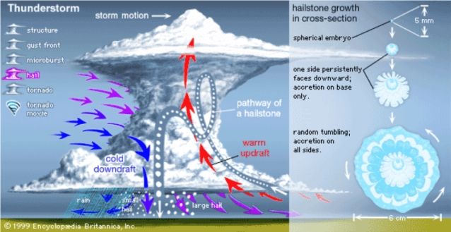
City of Canyon Hazard Mitigation Plan 2020 Page 26Hail
Description
Hail is a form of solid precipitation. It consists of balls or irregular lumps of ice, each of which is called a
hailstone. A Hailstorm is, “any storm that produces hailstones that reach the ground.”
Hail is produced by ice crystals that form in a low pressure front due to the rapid rising of
warm air into the upper atmosphere and subsequent cooling of the air mass. Hail usually
falls as shaped masses of ice greater than 0.25 inches in diameter. The size of the hail can
be directly correlated with the size of the thunderstorm.
Hailstorms are an outgrowth of severe thunderstorms.
People outdoors would be the most likely victims during a
hailstorm, but the biggest threat would come from large
hailstones and damage they would cause to property.
The table below provides definition to the various sizes or
categories of hail and the potential damage that can be
caused by hail of that size.
NWS/TORRO Hail Scale
Combined NOAA/TORRO Hailstorm Intensity Scales
Typical Hail
Size Code Intensity Category Diameter Approximate Size Typical Damage Impacts
(inches)
H0 Hard Hail up to 0.33 Pea No damage
H1 Potentially 0.33-0.60 Marble or Mothball Slight damage to plants, crops
Damaging
H2 Potentially 0.60-0.80 Dime or grape Significant damage to fruit, crops, vegetation
Damaging
H3 Severe 0.80-1.20 Nickel to Quarter Severe damage to fruit and crops, damage to glass and
plastic structures, paint and wood scored
H4 Severe 1.2-1.6 Half Dollar to Ping Pong Widespread glass damage, vehicle bodywork damage
Ball
H5 Destructive 1.6-2.0 Silver dollar to Golf Ball Wholesale destruction of glass, damage to tiled roofs,
significant risk of injuries
H6 Destructive 2.0-2.4 Lime or Egg Aircraft bodywork dented, brick walls pitted
H7 Very destructive 2.4-3.0 Tennis ball Severe roof damage, risk of serious injuries
H8 Very destructive 3.0-3.5 Baseball to Orange Severe damage to aircraft bodywork
H9 Super Hailstorms 3.5-4.0 Grapefruit Extensive structural damage. Risk of severe or even
fatal injuries to persons caught in the open
H10 Super Hailstorms 4+ Softball and up Extensive structural damage. Risk of severe/fatal
injuries to persons in the open
Source: www.noaa.gov and www.torro.org
City of Canyon Hazard Mitigation Plan 2020 Page 27Location
The entire planning area can anticipate frequent hailstorms that can contribute to property and crop damage.
Extent
Year
While the average size of hail encountered throughout the
Average Hail Size
planning area, measured by the diameter, is 1.34 In., there
2015 1.58 in have been many occurrences when the diameter measured
2016 1.50 in 1.25” and as high as 2.50” a range of H5-H7 on the combined
2017 NOAA/TORRO Hailstorm Intensity Scale. In previous years
1.16 in
the City of Canyon has seen hail up 4.00, therefore, the entire
2018 1.17 in planning area can experience up to a H10, with typical hail
2019 1.37 in diameter of 1.0-1.25 inches
2020 1.21 in.
Hail of this size can decimate crops, roofs, and injure people who are not inside. No matter the size of the
hail – the largest losses seen through any size of hail is vehicular damage, amounting to hundreds of
thousands of dollars in claims, many times what could be considered repetitive loss depending on the age and
repair history.
Impact
Hail can cause considerable damage to crops and property. Injuries and deaths can occur as direct result both
to people and to livestock who are not under shelter. Hail damage to both vehicles and buildings (glass) can
minimize work for government. Repairs cause can cause a significant reduction in workforce as employees
are without transportation to go to work due to reparation of vehicles or waiting for contractors to conduct
home repairs.
Vulnerabilities
Roof, HVAC and window damage to critical city facilities to include city hall, police & fire
City of Canyon
department, parks and rec, street depot, animal shelter, water park, and, library.
Control systems and building damage at the City Water and Wastewater Treatment Plants.
City vehicle body and glass Windows: Specifically damage to Canyon emergency response
vehicles and public works vehicles required to still be out on the roads responding to calls
during hailstorm events.
Damage to school buildings to include roofs, HVAC units, and windows
Canyon ISD
o School buildings (61 total)
o HVAC Units (939 total)
Damage to 77 school buses’ bodies and windows and various other school-owned vehicles. All
are unprotected.
Hailstorm impacts could cause school closures, accidents, staff/student injuries
City of Canyon Hazard Mitigation Plan 2020 Page 28Probability of Future Events
Specific damage loss numbers as reported by NOAA Storm Events Database were used to produce the data
for the estimation of future loss. It is important to understand that the true financial impact due to hailstorms
are difficult to state. Property damage information for residents who make insurance claims to home
insurance or vehicle insurance are typically not included in the Storm Event data. Therefore, you can make
the conclusion that the property damage is probably double the reported range.
Years in
Probability of No. of Events Future Probability of 1 or
Record Span Computation
Future Events in the Span more events year
2015-2020
Unincorporated Area 5 30 (30/5)*100 600%
Previous Occurrences-July 1, 2015- July 31, 2020
Location Date Type Mag Dth Inj PrD CrD
Randall County 7/8/2015 Hail 2.75 in. 0 0 0.00K 0.00K
Randall County 7/16/2015 Hail 1.00 in. 0 0 0.00K 0.00K
Randall County 11/16/2015 Hail 1.00 in. 0 0 0.00K 0.00K
Randall County 6/9/2016 Hail 0.88 in. 0 0 0.00K 0.00K
Randall County 6/13/2016 Hail 1.75 in. 0 0 0.00K 0.00K
Randall County 7/14/2016 Hail 1.25 in. 0 0 0.00K 0.00K
Randall County 6/8/2017 Hail 1.00 in. 0 0 0.00K 0.00K
Randall County 6/24/2017 Hail 1.75 in. 0 0 0.00K 0.00K
Randall County 7/2/2017 Hail 0.75 in. 0 0 0.00K 0.00K
Randall County 7/3/2017 Hail 1.25 in. 0 0 0.00K 0.00K
Randall County 5/19/2018 Hail 0.88 in. 0 0 0.00K 0.00K
Randall County 6/12/2018 Hail 1.00 in. 0 0 0.00K 0.00K
Randall County 9/1/2018 Hail 1.75 in. 0 0 0.00K 0.00K
Randall County 12/26/2018 Hail 1.00 in. 0 0 0.00K 0.00K
Randall County 3/22/2019 Hail 2.50 in. 0 0 0.00K 0.00K
Randall County 4/17/2019 Hail 1.00 in. 0 0 0.00K 0.00K
Randall County 4/27/2019 Hail 0.75 in. 0 0 0.00K 0.00K
Randall County 4/30/2019 Hail 1.75 in. 0 0 0.00K 0.00K
Randall County 5/5/2019 Hail 1.00 in. 0 0 0.00K 0.00K
Randall County 5/6/2019 Hail 1.25 in. 0 0 0.00K 0.00K
Randall County 5/7/2019 Hail 1.00 in. 0 0 0.00K 0.00K
Randall County 5/20/2019 Hail 1.00 in. 0 0 0.00K 0.00K
Randall County 5/23/2019 Hail 1.75 in. 0 0 0.00K 0.00K
Randall County 5/26/2019 Hail 1.00 in. 0 0 0.00K 0.00K
Randall County 6/1/2019 Hail 1.75 in. 0 0 0.00K 0.00K
Randall County 6/18/2019 Hail 2.00 in. 0 0 0.00K 0.00K
Randall County 7/10/2019 Hail 1.00 in. 0 0 0.00K 0.00K
Randall County 5/11/2020 Hail 1.25 in. 0 0 0.00K 0.00K
Randall County 5/23/2020 Hail 0.88 in. 0 0 0.00K 0.00K
Randall County 6/19/2020 Hail 1.50 in. 0 0 5.00M 0.00K
City of Canyon Hazard Mitigation Plan 2020 Page 29Lightning
Description
Lightning events are generated by atmospheric imbalance and turbulence due to the
combination of the following conditions: unstable warm air rising rapidly into the
atmosphere; sufficient moisture to form clouds and rain; and upward lift of air currents
caused by colliding cold and warm weather fronts, sea breezes or mountains. Lightning is
generated by the buildup of charged ions in a thundercloud, and the discharge of a lightning
bolt interacts with the best conducting object or surface on the ground. The air channel of a
lightning strike reaches temperatures higher than 50,000 degrees Fahrenheit.
Dry lightning is lightning that occurs without rain nearby. The NOAA Storm Prediction Center routinely
forecasts dry lightning because this kind is more likely to cause wildfires.
Location
The entire planning area is uniformly exposed to lightning which strikes in very small, specific geographic
areas.
Extent
Lightning affects the entire county and can occur anywhere. Historical data from the National lightning
Detection Network for the years 2007-2017 shows 6-12 strikes per year. Based on the frequency of lightning
in the planning area, it falls under a scale of LAL3 in the Lightning Activity Level scale, meaning it is
anticipated to experience greater than 6 cloud to ground strikes in a 5 minute period.
City of Canyon Hazard Mitigation Plan 2020 Page 30Impact
Lightning strike can ignite wildfires, direct strikes on water wells can put utilities out of commission for a
significant period of time. Electronic equipment including communications, critical hospital equipment can
be disabled if the building suffers a direct strike.
May 8, 2018 – lightning strike sparked a wildfire consuming over 270 acres
April 2015 – lightning strike impacted the Jr/High School and caused severe damage to the freezer and air
conditioning system. Total repair costs were over $20,000.
Vulnerabilities
Electrical surges for computer and other sensitive office equipment within City Hall, Fire
Department, Police Department, Parks and Rec, Street Depot, Animal Shelter, Water Park, and
Library.
City of Canyon
Water and sewer control systems from lightning strikes on pumps and other electrical
equipment causing malfunction / work stoppage.
Radio tower, communications system, radar equipment located at the Police Department, Fire
Department, and EMS facilities causing disruption of service, possibly spark fires, and increase
emergency response need
Serious injury of death to those not in a sheltered area by electrocution.
Canyon ISD Campuses (23 campuses), 77 school buses, 61 total buildings, admin offices, 939
Canyon ISD
HVAC units, and sports complexes – damage to electronic control systems and sensitive
electronic computer equipment housed in the buildings. Serious injury of death to those not in a
sheltered area by electrocution. Impact could cause school closures, accidents, staff/student
injuries.
Previous Occurrences
A lightning strike impacting one of the participants has occurred in every jurisdiction at least each year to
date. While computer systems are very vulnerable – the majority of large wildfires within this county are
caused by lightning strikes.
Probability of Future Events
Statewide Texas has a significant exposure to thunderstorms and lightning. Overall, lightning is the most
constant and widespread threat to people and property during the thunderstorm season. The recurrence of
lightning is high. Dry lightning has the likelihood of being the spark for large fires in the county. Reporting
of lightning strikes to the weather service is very limited. A history based on repairs to government systems
was used to develop the probability of future events and to also populate the previous occurrences.
Probability of a lightning event occurring anywhere in the planning area is 100% probable in the next 5
years.
City of Canyon Hazard Mitigation Plan 2020 Page 31Tornado
Description
A tornado appears as a rotating, funnel-shaped cloud that extends from a thunderstorm to
the ground with whirling winds that can reach 300 miles per hour. Damage paths can be in
excess of one mile wide and 50 miles long. Some tornadoes are clearly visible, while rain
or nearby low-hanging clouds obscure others. Occasionally, tornadoes develop so rapidly
that little, if any, advance warning is possible.
Each year, an average of over 1,000 tornadoes are reported nationwide, resulting in
an average of 80 deaths and 1,500 injuries. They are more likely to occur during the
spring and early summer months of March through June and can occur at any time
of day, but are likely to form in the late afternoon and early evening.
The Enhanced Fujita (EF) Scale for tornadoes was developed to measure tornado
strength and associated damages; it is divided into six categories from zero to five
representing increasing degrees of damage. Overall, most tornadoes (around 77 percent) in the U.S. are
considered weak (EF0 or EF1) and about 95 percent of all U.S. tornadoes are below EF3 intensity. The remaining
small percentage of tornadoes are categorized as violent (EF3 and above).
Enhanced Fujita (EF) Scale
Enhanced Fujita (EF) Scale
Enhanced Fujita Wind Speed
Category (mph) Potential Damage
EF0 65-85 Light damage
Peels surface off some roofs; some damage to gutters or siding; branches broken off
trees; shallow-rooted trees pushed over.
EF1 86-110 Moderate damage
Roofs severely stripped; mobile homes overturned or badly damaged; loss of
exterior doors; windows and other glass broken.
EF2 111-135 Considerable damage
Roofs torn off well-constructed houses; foundations of frame homes shifted; mobile
homes completely destroyed; large trees snapped or uprooted; light-object missiles
generated; cars lifted off ground.
EF3 136-165 Severe damage
Entire stories of well-constructed houses destroyed; severe damage to large
buildings such as shopping malls; trains overturned; trees debarked; heavy cars
lifted off the ground and thrown; structures with weak foundations blown away
some distance.
EF4 166-200 Devastating damage
Well-constructed houses and whole frame houses completely leveled; cars thrown
and small missiles generated.
EF5 >200 Incredible damage
Strong frame houses leveled off foundations and swept away; automobile-sized
missiles fly through the air in excess of 100 m (109 yd.); high-rise buildings have
significant structural deformation; incredible phenomena will occur.
City of Canyon Hazard Mitigation Plan 2020 Page 32You can also read