PLANNING APPLICATIONS COMMITTEE - Thursday, 11 February 2021, 2.00 pm Virtual Meeting
←
→
Page content transcription
If your browser does not render page correctly, please read the page content below
You can view the agenda
                                                                                                online by using a smart
                               Public Document Pack                                             phone     camera     and
                                                                                                scanning the code below:

            PLANNING APPLICATIONS COMMITTEE
             Thursday, 11 February 2021, 2.00 pm
                       Virtual Meeting
                          Contact Officer: Pat Trafford. 01538 395551 -
                             pat.trafford@staffsmoorlands.gov.uk

          SITE VISITS:         As site visits cannot currently be undertaken
                               members of the Committee will be shown a video on
                               the morning of the meeting giving all necessary
                               views of the applications on the agenda.

Speaking at Committee: Under the Council's Constitution, applicants (or their
agent) and objectors/supporters are eligible to speak at this Committee for 3 minutes
each. The maximum number of speakers on any item is six (three speakers for and
three speakers against) plus any Ward Councillors. All speakers, including Ward
Councillors, should register with Democratic Services (email
democratic.services@staffsmoorlands.gov.uk or tel: 01538 395551)
from 10.00 a.m. the day after the agenda is published until 4.00 p.m. on the
Monday of the week of the meeting. Also please note that speakers need to re-
register if an application has been previously withdrawn from an agenda. Registered
speakers should join the meeting no later than 15 minutes before the start of the
meeting (guidance will be provided during registration).

An information leaflet relating to these procedures is available from the main Council
Offices, on the Council’s website and will be available at the meeting. Speakers are
advised to read the leaflet prior to the meeting.

The order of business on the agenda may change at the discretion of the Chair. As
it is not possible to give a precise time when an item may be discussed, it is always
advisable to arrive for the start of the meeting.

Please be aware that meetings will be broadcast vie the Council’s website and may
be recorded by representatives of the media or by members of the public. A
guidance document for the recording of public Council meetings is available on the
Council’s website.

                                                                                                       P.T.O.

                                          www.staffsmoorlands.gov.uk
          Moorlands House, Stockwell Street, Leek, Staffordshire Moorlands, ST13 6HQ. Tel: 0345 605 3010
Planning Applications Committee - Thursday, 11 February 2021

                                  A G E N D A (Continued)

1.    Chair's announcements

         a) Webcasting;
         b) Introductions of Members and Officers;
         c) Other announcements.

2.    Apologies for absence, if any.

3.    Minutes of the previous meeting (Pages 5 - 10)

             (a)   To approve as a correct record the Public Minutes of the Planning
                   Applications Committee held on 14 January 2021.

             (b)   Reports on matters arising, if any.

4.    Urgent items, if any.

5.    Declarations of Interest

      i. Disclosable Pecuniary Interests;
      ii. Other Interests;
      iii. Lobbying Interests.

6.    SMD/2020/0645 - Greywoods, Cheddleton Road, Leek (Pages 11 - 24)

7.    SMD/2020/0201 - Land adjacent to Marsh Villa, Macclesfield Road, Rushton
      Spencer (Pages 25 - 48)

8.    SMD/2020/0575 - Stanhopea, Mill Lane, Wetley Rocks (Pages 49 - 58)

9.    SMD/2020/0441 - Plots 12 - 15 Victoria Business Park, Prospect Way,
      Knypersley (Pages 59 - 74)

10.   NOTE - A Late Representations Report will be circulated prior to the meeting i.e.
      any representations received since this agenda was published.

11.   Exclusion of the Press and Public

12.   Enforcement Complaint relating to an address in Winkhill (Pages 75 - 78)
      (Paragraph 2 - Information which is likely to reveal the identity of an
      individual. )

      Published 3 February 2021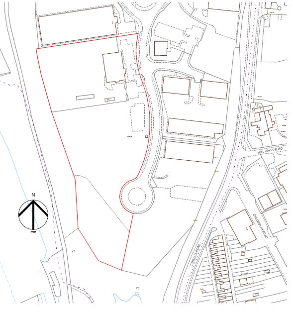
Planning Applications Committee - Thursday, 11 February 2021

                  A G E N D A (Continued)

Membership of Planning Applications Committee
Councillor P Roberts (Chair)       Councillor B Emery (Vice-Chair)
Councillor B Cawley                Councillor S Coleman
Councillor J Davies                Councillor K Flunder
Councillor M Gledhill              Councillor T Holmes
Councillor K Hoptroff              Councillor A Hulme
Councillor L D Lea                 Councillor T Riley
Councillor P Wilkinson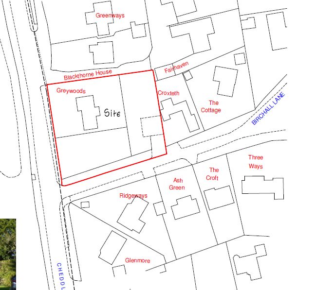
This page is intentionally left blank
Agenda Item 3
        STAFFORDSHIRE MOORLANDS DISTRICT COUNCIL

       PLANNING APPLICATIONS COMMITTEE MEETING
                                           Minutes
                      THURSDAY, 14 JANUARY 2021
      PRESENT:             Councillor P Roberts (Chair)

                           Councillors B Cawley, S Coleman, J Davies, B Emery, K Flunder,
                           M Gledhill, T Holmes, K Hoptroff, A Hulme, L D Lea, T Riley and
                           P Wilkinson

      IN ATTENDANCE:       S Hampton            Member and Community Services Officer
                           P Trafford           Member & Community Services Officer
                           L Vernon             Senior Officer (Governance and Member
                                                Support)
                           J Curley             Principal Planning Officer
                           B Haywood            Head of Development Services
                           J Price-Jones        Legal Advisor

186   CHAIR'S ANNOUNCEMENTS

         a) The Chair confirmed that the meeting was being broadcast live to the internet
            via the usual webcasting facility and was capable of repeated viewing. The
            images and sound recording could be used for training purposes within the
            Council. The Chair had the discretion to terminate or suspend filming if it was
            his opinion that continuing to do so would prejudice the proceedings of the
            meeting. In the light of this meeting being held ‘virtually’ via the Microsoft
            Teams platform, all members were asked to adhere to the guidelines
            previously issued to them for such meetings, to use the ‘Hands up’ function to
            register their wish to speak and to speak only when invited to do so by the
            Chair. All attendees were asked to keep their microphones muted when not in
            use. Any views expressed by any speaker in the meeting were the speaker’s
            own and did not necessarily reflect the views of Staffordshire Moorlands
            District Council.
         b) Members of the Committee and Officers present were introduced by the
            Chair.
         c) The Chair requested that mobile phones be switched off or to silent.
         d) Given the social distancing restrictions in place due to the Coronavirus
            Pandemic, no actual site visits were undertaken relating to this meeting.
            However, photos/video were shown to all members both before and during
            the meeting showing all views of the application sites.

187   MINUTES OF THE PREVIOUS MEETING

      RESOLVED – That the public minutes of the meeting of the Planning Applications
                 Committee held on 3 December 2020 be APPROVED as a correct
                 record and signed by the Chair.

      (Proposed by Councillor Riley and seconded by Councillor Emery.)
                                           Page 5
                                               1
Planning Applications Committee - 14 January 2021
188 URGENT ITEMS, IF ANY.
There were no urgent items.
189 DECLARATIONS OF INTEREST
The following declarations were made at this point, unless stated otherwise:-
Member Declaring
Agenda Item Nature of Interest
Interest
Cllrs. Cawley, Coleman,
Agenda Item 6 – Davies, Emery, Flunder,
Lobbied – No response
SMD/2020/0301 – Gledhill, Holmes, Hoptroff,
given
Former Meadows Hulme, Lea, Riley,
Special School Site, Roberts and Wilkinson
Tunstall Road,
Knypersley “Other” – County Councillor
Cllr. Flunder
for neighbouring area
Cllrs. Cawley, Coleman,
Davies, Emery, Flunder,
“Other” – Speaker was an
Gledhill, Holmes, Hoptroff,
ex-SMDC employee
Agenda Item 7 – Hulme, Lea, Riley,
SMD/2020/0299 – Roberts and Wilkinson
Sub 4 Health, Leek Cllrs. Cawley, Coleman,
Road, Cellarhead Davies, Emery, Flunder,
Lobbied – No response
Gledhill, Holmes, Hoptroff,
given
Hulme, Lea, Riley,
Roberts and Wilkinson
190 SMD/2020/0301 - FORMER MEADOWS SPECIAL SCHOOL SITE,
TUNSTALL ROAD, KNYPERSLEY
DEVELOPMENT OF A NEW FOOD STORE (USE CLASS A1), ASSOCIATED
PARKING, ACCESSING, SERVICING AND LANDSCAPING FOR ALDI STORES
LIMITED.
(Report recommended approval)
All Councillors had declared lobbying interests. Councillor Flunder declared an
“other” interest. Councillor Lea left the meeting part way through the item and took
no part in the vote.
RECEIVED – Representations from the undermentioned speakers:-
For the application:
Cllr. John Jones - Biddulph Town Cllr.
Mr. George Brown - Applicant
Mr. Stanley Leach - Supporter
NOTED - 1. LRR contained:-
Page 6
2Planning Applications Committee - 14 January 2021
Site access arrangements plan 20119 GA 03 Rev
C to be added to the plans list in Condition 2;
Amendment condition 18, strengthened to ensure
hatched area cleared and fence set back on new splay line;
Additional condition for road markings to deter
cars from using the private access to exit the site;
Additional condition to secure a Landscape and
Ecology Landscape Plan;
6 further letters of support;
Applicant’s response to Police Architectural
Liaison Officer.
2. Aldi had increased their offer for the biodiversity offsetting commuted
sum to £22 000 which Officers, advised by Staffordshire Wildlife
Trust now considered to be acceptable. An opportunity exists for the
enhancement to be made on land adjacent to the Biddulph Valley
way (Amenity site 7 on SMDC Table of suggested management and
biodiversity opportunities). The contribution would need to be
secured in a legal agreement.
3. An amended Landscape plan was required to ensure that it aligns
with the Site Access Arrangements plan. The applicant had agreed
to revise in line with Officer advice.
4. Final response/conditions were awaited from the Local Lead Flood
Authority.
5. Members expressed a wish for Aldi to work with all parties to try to
facilitate the provision of a through bus service to the site.
3. The Chair and members thanked the Applicant for their work on the
site thus far.
RESOLVED – That the application be APPROVED for the reasons and based on
the policies stated in the report, subject to the conditions and
informatives contained in the report and as amended above and the
additional conditions referred to above and the receipt of an
amended Landscape Plan.
FURTHER RESOLVED - In the event of any changes being needed to the wording
of the Committee’s decision (such as to delete, vary or add
conditions / informatives / planning obligations or reasons for
approval / refusal), prior to the decision being issued the Head of
Development Services had delegated authority to do so in
consultation with the Chairman of the Planning Applications
Committee, provided that the changes did not exceed the
substantive nature of the Committee’s decision.
(Proposed by Councillor Davies and seconded by Councillor Flunder.)
Councillor Lea joined the meeting during the consideration of this item and therefore
took no part in the vote.
Page 7
3Planning Applications Committee - 14 January 2021
191 SMD/2020/0299 - SUB 4 HEALTH, LEEK ROAD, CELLARHEAD
PROPOSED ERECTION OF SINGLE STOREY COMMERCIAL BUILDING (B1
LIGHT INDUSTRIAL) FOR THE PRODUCTION OF NUTRACEUTICALS
PRODUCTS FOR MR. CLIFTON BRADELEY.
(Report recommended approval)
All Councillors had declared “other” and lobbying interests. Councillor Lea re-joined
the meeting part way through this item and therefore took no part in the vote.
RECEIVED – Representations from the undermentioned speaker:-
For the application:
Mr. Rob Duncan - Applicant’s Agent
NOTED - 1. Additional conditions requested by members:-
Operating hours to be restricted to Monday to
Friday – 9am to 5.30pm;
Installation of Electric Vehicle Charging Points in
the car park.
RESOLVED – That the application be APPROVED for the reasons and based on
the policies stated in the report, subject to the conditions contained
in the report and the additional conditions referred to above.
FURTHER RESOLVED - In the event of any changes being needed to the wording
of the Committee’s decision (such as to delete, vary or add
conditions / informatives / planning obligations or reasons for
approval / refusal), prior to the decision being issued the Head of
Development Services had delegated authority to do so in
consultation with the Chairman of the Planning Applications
Committee, provided that the changes did not exceed the
substantive nature of the Committee’s decision.
(Proposed by Councillor Emery and seconded by Councillor Hoptroff.)
192 TPO/2020/0052 - APPLICATION TO FELL PROTECTED TREES AT
BIRCHWOOD HOUSE / ST MARY'S MOUNT, RAMSHORN ROAD,
OAKAMOOR
(Report recommended Approval)
CONSIDERED – An application for forestry operations within Compartments 1 and 2
as shown on the map appended to the report, in so far as they lie
within the extent of Woodland W1 protected under Tree
Preservation Order (TPO) No. SM. 105
NOTED - 1. The application was brought before the committee due to its nature
Page
(forestry operations). This 8 normally be dealt with by the Forestry
would
4Planning Applications Committee - 14 January 2021
Commission as a Felling Licence. However the Forestry Commission
had deemed that this application was better dealt with as a TPO.
2. Consultation had been carried out with the Parish Council and the 7
nearest residents, given the substantial nature to the proposal.
RESOLVED – That consent be APPROVED for the proposed forestry operations
within Compartments 1 and 2 within Woodland W1, protected by TPO
No. SM. 105, subject to the conditions contained within the report.
(Proposed by Councillor Emery and seconded by Councillor Cawley.)
The meeting closed at 3.55 pm
_________________________________Chairman ____________________Date
Page 9
5This page is intentionally left blank
Agenda Item 6

               STAFFORDSHIRE MOORLANDS DISTRICT COUNCIL
                    PLANNING APPLICATIONS COMMITTEE

                                    11 February 2021

 Application       SMD/2020/0645
 No:
 Location         Greywoods, Cheddleton Road, Leek
 Proposal         Outline Application with Details of Access for Two New-Build
                  Dwellings on Part of Garden at Greywoods
 Applicant        Mr John Cowburn
 Agent            Mr Robert McGuinness
 Parish/ward      Leek                            Date registered: 18th November
                                                  2020
 If you have a question about this report please contact: Chris Johnston, tel: 07976
 753864, email: Christopher.johnston@staffsmoorlands.gov.uk

REFERRAL

This application is before committee because a large number of letters/emails of
objection have been received from local residents.

1. SUMMARY OF RECOMMENDATION

 APPROVE with conditions

2. DESCRIPTION OF THE SITE AND ITS SURROUNDINGS

2.1      The application site is in the residential area of Birchall, within the development
boundary of Leek, in an area comprising detached dwellings with a mix of
designs/styles. The site itself contains a large residential plot with an “Arts and Crafts”
style detached dwellinghouse facing Cheddleton Road to the west and with large
garden areas to the rear and south side of the house. Birchall Lane runs along the
south side boundary of the site. There are dwellings facing the lane to the other side
of it further to the south.

2.2    To the north side of the site is an access road/drive off Cheddleton Road which
serves a couple of backland dwellings to the north-east of the site and there are other
dwellings facing the road to the other side of this shared “drive”. There are other
detached dwellings directly to the rear (east) with the side of the neighbouring house
to the rear facing the rear boundary of the site. To the west of the site to the other
side of the main road lies a golf course belonging to Leek Golf Club. The vehicular
access to Greywoods is off Birchall Lane near the back of the site and leads to a large
detached garage close to the rear boundary of the site. There is a pedestrian access
gate off Cheddleton Road to the front of the house. There are several large trees
alongside the Cheddleton Road boundary, within the site. There are other trees within
the garden areas.

                                         Page 11
3. THE APPLICATION AND DESCRIPTION OF THE PROPOSAL
3.1 This is an outline application for the subdivision of the whole site into three
residential plots with the existing house retained, and two new houses built in the other
two rectangular plots which would be to the rear of the current house and to the south
side. A new vehicular access would be built off Cheddleton Road close to the north
side boundary, which would serve the existing dwelling and lead to a parking and
turning area with new detached double garage to the north side of the current house.
The existing vehicular access to the property would be retained to serve the new
residential plot to the rear of the current house. A new vehicular access would be built
further along Birchall Lane (closer to the main road junction) to serve the new
residential plot to the side of the current house.
3.2 The outline application seeks approval for the principle of the development and
also the details of access only. The particular scale/size of the new houses, the
layout/siting of the new houses, their design and appearance and the landscaping of
the overall site are reserved for a future “Reserved Matters” planning application. A
site plan has been submitted showing the footprint of the new detached dwelling on
the rear plot, replacing the current garage to the existing house (which would be
demolished) and with a parking/turning area next to the Birchall Lane access and a
garden to the north of the proposed house and also another detached footprint of a
house, proposed to the side of the current dwelling, with a parking and turning area
next to the new access which would be to the east of the house and a garden area to
the west of the proposed new house, next to Cheddleton Road. This is the opposite
orientation to the current house which has a front elevation facing Cheddleton Road
and a garden to the rear, to the east of the house. The site plan also shows the
retention of “some” of the tree belt along the current front boundary of the site next to
Cheddleton Road. However, it must be stressed that the site plan is purely indicative
to demonstrate roughly how two further dwellings can be accommodated on the overall
site. The details on the drawing are not to be determined as part of this current outline
application as matters such as the particular scale, siting, layout and landscaping are
left for the future Reserved Matters application.
3.3 Amended plans were received in mid-December 2020 showing the relocation of
the access for the side plot moved further away from the junction of Birchall Lane and
Cheddleton Road and the indicative layouts showing the parking and turning area
moved to the east side of the indicative building footprint from the west side where the
original proposed access was located.
3.4 The application form states that one of the dwellings would be a 3-bed dwelling
with the other “4-bed plus”. There would be six parking spaces in total to serve the
three dwellings. Drainage would be via mains sewer (for foul drainage) and
soakaways (for surface water).
3.5 Details of the application scheme can be viewed at:
Page 12http://publicaccess.staffsmoorlands.gov.uk/portal/servlets/ApplicationSearchServlet?
PKID=142065
4. RELEVANT PLANNING HISTORY
None for this particular site.
5. PLANNING POLICIES RELEVANT TO THE DECISION
Staffordshire Moorlands Local Plan (Adopted Sept 2020)
5.1 The Development Plan comprises the Local Plan Development Document
(adopted September 2020).
5.2 The following Local Plan policies are relevant to the application:
SS1 Development Principles
1a Presumption in Favour of Sustainable Development
SS2 Settlement Hierarchy
SS5 Leek Area Strategy
H1 New Housing
DC1 Design Considerations
T1 Development and Sustainable Transport
NE2 Trees, Woodland and Hedgerows
National Planning Policy Framework (NPPF) Revised (2019)
5.3 The following sections of the NPPF (2019) are particularly relevant to this
application:
2: Achieving sustainable development
4: Decision making
5: Delivering a Sufficient Supply of Homes
12: Achieving well-designed places
15: Conserving and enhancing the natural environment
6. CONSULTATIONS
Neighbour letters Expiry date for comments in relation to latest
revised plans: 29/12/2020
Site Notice Posted 07/12/2020
Press Notice N/A
Public response to consultation
6.1 Twenty-eight letters of objection have been received, eleven if which were
received in response to the consultation on the amended plans in mid-December
2020. The main planning-related points raised are as follows:
Page 13- Inadequate parking and turning areas, lack of garages and accesses close
together will cause road congestion
- Hedges and trees not taken into account
- Orientation of the dwelling at side not in keeping with area
- Overdevelopment and overcramped form of development harming the spacious
character of the area
- Building sizes and proportions not in keeping with surrounding buildings
- Loss of privacy particularly affecting Croxteth, the neighbouring dwelling to the
east of the site
- Loss of light and afternoon sunlight to Croxteth which has a north-facing garden
- The high quality architectural and historic design and appearance of the existing
house and the mature gardens forming an entrance to the Birchall estate would
be harmed
- Highway safety affected by a new driveway built so close to the main road
junction
- The site is located over a mile from the town centre and therefore is an
unsustainable site
- Road junction is unsafe
- Highway safety of Birchall Lane will be affected as there is no footway or lighting
Cheddleton Parish Council
6.2 Leek Town Council strongly object on the following grounds:
-Scale of the development is overbearing for the plot size and would ruin the
appearance and character of Greywoods.
-It is out of character for the area.
-Traffic concerns regarding access, as Birchall Lane is very narrow.
-It would impact on neighbouring properties.
SCC Highway Authority
6.3 An objection was raised in response to the original plans which showed a new
Birchall Lane access closer to the junction with Cheddleton Road. This was
considered to affect highway safety.
No objection subject to conditions was raised in response to the amended plans
showing the access moved further along Birchall Lane away from the road junction.
SMDC Environmental Health
6.4 No objection subject to standard conditions.
SMDC Waste Collection Services
6.5 No issues with waste collections
Severn Trent Water
Page 146.6 No objection to the proposals and do not require a drainage condition to be
applied.
7. OFFICER COMMENT AND PLANNING BALANCE
7.1 The main issues relate to:
The principle of the development in this location.
Impact on the character and appearance of the surrounding area.
Impact on residential amenity.
Impact on highway safety.
The principle of the development
7.2 The site is within the development boundary of Leek. The recently adopted new
Local Plan sets out the strategy for new housing in the District and although this sets
out new allocations of housing land to deliver the required amount of new housing for
the District over the plan period, addressing the shortfall before the adoption of the
plan, where a “five year housing land supply” could not be demonstrated, new housing
on “windfall sites” such as other plots within the towns and village, can still positively
contribute towards the supply and range of housing. The Development Plan still
continues to allow new houses within the identified development boundaries of towns
and villages providing that all other policies in the Local Plan and in the NPPF are
complied with.
7.3 The principle of providing new housing in this location is therefore acceptable and
although the site is at least a mile from the town centre, it is still accessible via a
reasonable walk along lit footways along the main road or by cycling or by public
transport from nearby bus stops on the main road. The site is therefore in a
sustainable location for additional housing. The proposal complies with Policy H1 in
terms of the principle of development and the location of the site for housing.
The impact on the character and appearance of the area
7.4 Policy H1 of the Local Plan states that all housing development should be at the
most appropriate density compatible with the site and its location, and with the
character of the surrounding area. Higher densities will generally be appropriate in
locations which are more accessible by public transport and which have good access
to services.
7.5 Policy DC1 also states that all development should be designed to respect the
site and its surroundings and promote a positive sense of place and identity through
its scale, height, density, layout, siting, landscaping, character and appearance.
7.6 Birchall is generally characterised by detached dwellings with differing designs in
spacious plots but of varying sizes and there is no uniform shape and size to the
plots throughout Birchall. In the east part of Birchall, the plot sizes tend to be larger.
The site is at the entrance to Birchall Lane in the west part of Birchall where plots
tend to be smaller. The application site is something of an exception as it is
considerably larger than the plots to the north, south and east (the land to west is
Page 15open land forming the golf course). The indicative site plan submitted with the
application shows a subdivision of the site into three plots of at least similar overall
size to the existing plots immediately surrounding the site and with plot widths and
lengths akin to some of the other nearby plots i.e. the two plots for the new houses
would have similar widths and lengths to Ash Green and The Croft on the opposite
side of Birchall Lane. It is therefore considered the creation of the new plots would
not be out of keeping with the surrounding residential area and would not lead to a
comparatively overcramped form of development and would be able to
accommodate a dwelling with sufficient space around it without harming the street
scene or character of the area.
7.7 The subdivision of existing plots into smaller plots in Birchall is also not out of
character with the area as approvals have been given for new housing at existing
residential properties in Birchall such as at Heather Hills, Birchall House and
Westover. Although these appear to be larger plots than the average plots sizes
closer to the application site, the application site itself is considerably larger than the
neighbouring plots.
7.8 Although the indicative site plan shows the dwelling to the side appearing to have
a side elevation facing Birchall Lane and a rear elevation facing Cheddleton Road,
this is not out of keeping with the rest of Birchall where development has occurred in
a rather sporadic form without well defined front building lines found in many (higher
density) streets elsewhere and where there are a number of houses which do not
have a front or primary elevation directly facing, or visible from, the road.
7.9 The actual scale and form of the new dwellings is not to be determined at this
stage of the process. However, in consideration of the scale and form of
surrounding dwellings, the indicative application drawing demonstrates that a
dwelling of similar form and scale as those found in the surrounding area can be
accommodated on each of the new plots.
7.10 Several of the letters of objection focussed on the high quality historical and
architectural “Arts and Crafts” style existing dwelling and how this would be harmed
by the proposed development. Whilst the dwelling does have some architectural and
historical merit, which contributes positively to the character and appearance of the
area, the house is not listed and Birchall is not in a Conservation Area. The area
comprises a mix of house types and styles, some modern and some traditional. The
style of the existing dwelling is not unique in the surrounding area and neither is it
prevalent in the area. The dwelling is proposed to be retained and not demolished.
The details of the design of the two new proposed dwellings which would sit adjacent
to it are not to be determined at this outline stage but there is potential to provide two
new dwellings with an equally high quality of design which could contribute to its
character and appearance and not detract from it, particularly as there is sufficient
space around the existing dwelling within the current property boundaries to locate
the two houses without causing an overbearing form, scale or design detracting from
its architectural qualities.
7.11 The indicative site plan also demonstrates that development can be provided on
the site without harming the large mature trees which also contribute positively to the
appearance of the site and the character and appearance of the wider area. The
Page 16tree belt is shown on the site plan and the indicative footprints are sufficiently clear of
the tree belt area. Furthermore, the exact siting of development is not to be
determined at this outline state. There is considered to be enough space within the
plot to site the dwellings away from the root zones of the trees when these are
established as part of a Tree Survey which can be undertaken at the later Reserved
Matters stage if the trees are also found to be healthy good quality specimens.
7.12 Overall, in terms of the impact on the character and appearance of the area, the
proposal complies with policies H1 and DC1 of the Local Plan.
The impact on the residential amenities of the area
7.13 Policy H1 states that all new dwellings must be of sufficient size to provide
satisfactory levels of amenity for future occupiers of the dwellings whilst respecting
the privacy and amenity of occupiers of existing dwellings.
7.14 Policy DC1 states that all development should protect the amenity of the area,
including the creation of healthy active environments and residential amenity, in
terms of satisfactory daylight, visual impact, sunlight, outlook, privacy, soft
landscaping as well as noise, odour and light pollution.
7.15 The impact on residential amenity cannot be fully assessed at this outline stage
as details of the scale and siting and also the design, including window positioning
are reserved matters. However, the indicative site plan demonstrates that two
decent sized dwellings can be provided to the rear and side of the current house in
compliance with the Council’s Space About Dwellings Supplementary Design
Guidance which sets out minimum distances between certain elevations of proposed
and existing dwellings, such as for example, 22.0 metres between opposing rear
elevations or front elevations and 14.0 metres between front and rear elevations and
flank walls, allowing sufficient levels of light provision and privacy to both the existing
residents and proposed new residents of the site. Garden lengths of at least 10.5
metres would be easily achievable allowing a sufficient level of residential amenity
for the proposed occupants.
7.16 The exact siting is not be determined at this stage of the process but based on
the indicative footprints of the houses, it would not be possible to harmfully overlook
the more private areas of existing and proposed rear gardens or into existing and
proposed primary windows if the proposed windows were to be located on the front
and rear elevations as is normal for new development and the window positioning
and exact footprint can be controlled at the Reserved Matters stage. The owners of
Croxteth to the east of the site raise concerns that the new dwellings would cause a
loss of privacy and reduce the amount of sun/day light to their property. However the
indicative plans shows that the closed dwelling could align with the front and rear
building line of the two storey element of this neighbour, which would ensure that
there would be no loss of light to this property. In any event, the siting and design of
the houses has been reserved for a latter date, and therefore the location of any
windows would be a matter to consider at this time. .
Page 177.17 Overall, in terms of the impact on residential amenity and the living conditions of
existing residents and the future occupants of the site, the proposal complies with
Policy H1 and DC1.
The impact on highway safety
7.18 Policy DC1 requires, amongst other matters, for development to provide for a
safe and satisfactory access and make a contribution to meeting the parking
requirement arising from necessary car use.
7.19 Birchall Lane is a private road but is also a Public Right of Way. Although there
are concerns that the development of two further dwellings could increase traffic on
the road causing safety concerns to pedestrians or increased risk of damage to the
road or verges, there would only be one additional new dwelling served by Birchall
Lane itself i.e. one new access onto it and any increase in traffic would not
significant. It is considered there is enough space within the proposed plots to
accommodate sufficient parking and turning areas to prevent the need to park on the
road, compromising highway safety. The new access onto Cheddleton Road is
deemed to be safe in terms of its siting and design and the site plan shows a parking
and turning area sufficient for three cars. The repositioning of the new access onto
Birchall Lane is deemed by the local highways authority (SCC) to be acceptable and
is a sufficient distance from the road junction to avoid any highway safety issues.
7.20 Overall, the proposed development in terms of highway safety is considered to
be acceptable and therefore the proposal complies with Policy DC1 of the Local
Plan.
Planning Balance & Conclusions
7.21 The proposed development is acceptable in principle as the site is located within
the development boundary of Leek and in a sustainable location with good access to
the town centre and a range of services in the town via walking, cycling and public
transport. Policy H1 supports the provision of housing on unidentified windfall sites
(such as parts of large residential gardens or large gaps between buildings) on
unallocated areas of land within the development boundaries of towns and villages.
7.22 The proposed additional two dwellings would not lead to the density of the
surrounding development being raised and due to the size of the site, there is the
potential to provide two dwellings without harming the character and appearance of
the area through high quality and appropriate scale, form, siting and design of
development to be determined at the future Reserved Matters stage, which would also
respect the quality of adjacent buildings such as the Arts and Crafts existing dwelling
on site and the high quality landscaping. The development can also be
accommodated on the site without comprising either the residential amenities/living
conditions of existing residents or the future occupants of the site. The proposal would
also not compromise the level of highway safety existing in the area. The application
would therefore comply with the Council’s adopted Local Plan and the government
planning guidance contained in the NPPF.
Page 188. RECOMMENDATION
That planning permission be APPROVED subject to the following conditions:
1. The development hereby permitted shall be begun either before the expiration
of three years from the date of this permission, or before the expiration of two
years from the date of approval of the last of the reserved matters to be
approved.
Reason:-
To comply with the provisions of Section 92 of the Town and Country Planning
Act 1990 (As Amended).
2. Application for approval of the reserved matters shall be made to the Local
Planning Authority before the expiration of three years from the date of this
permission.
Reason:-
To comply with the provisions of Section 91 of the Town and Country Planning
Act 1990 (As amended).
3. The approval of the Local Planning Authority shall be obtained in writing with
respect to the plans and particulars of the following reserved matters
(hereinafter called "the reserved matters") before any development is
commenced:
- Scale
- Siting
- Appearance
- Landscaping
Reason:-
The application is an outline application under the provisions of the Town and
Country Planning (Development Management Procedure) Order 2015 and no
particulars have been submitted with respect to the matters reserved in this
permission.
4. The development hereby approved shall be carried out in complete
accordance with the submitted plans and specifications as follows:-
Location Plan RLM1033/1 Rev B
Reason:-
To ensure that the development is carried out in accordance with the approved
plans, for clarity and the avoidance of doubt.
5. The existing dwelling on site shall be retained and no part of it shall be
demolished unless otherwise agreed in writing by the Local Planning Authority.
Reason:-
The existing dwelling contributes positively to the character and appearance of
the area.
Page 196. A detailed Arboricultural Method Statement (AMS) in accordance with
BS5837:2012 Trees in relation to design, demolition and construction -
Recommendations shall be submitted with any reserved matters application.
The AMS shall include full details of the following:
a) Detailed tree survey undertaken in accordance with recommendations of
BS5837 (2012).
b) Detailed tree felling and pruning specification in accordance with
BS3998:2010 Recommendations for Tree Works.
c) Details of a tree protection scheme in accordance with BS5837:2012 which
provides for the retention and protection of trees, shrubs and hedges growing
on or adjacent to the site which are shown to be retained on the approved plan
and trees which are the subject of any Tree Preservation Order.
d) Details of any construction works required within the root protection area as
defined by BS5837:2012 or otherwise protected in the approved Tree Protection
Scheme.
e) Details of the location of any underground services and methods of
installation which make provision for protection and the long-term retention of
the trees. Notwithstanding the provisions of The Town and Country Planning
(General Permitted Development) Order, 1995 (as amended by The Town and
Country Planning (General Permitted Development) Order 2015), no services
shall be dug or laid into the ground other than in accordance with the approved
details.
f) Details of any changes in ground level, including existing and proposed spot
levels required within the root protection area as defined by BS5837:2012 or
otherwise protected in the approved Tree Protection Scheme.
g) Details of any vehicular drives, parking areas and other hard surfacing within
the root protection area (as defined by BS5837:2012). The design and
construction must in accordance with the recommendations of BS5837:2012.
Include details of existing ground levels, proposed levels and depth of
excavation.
h) Details of the arrangements for the implementation, supervision and
monitoring of works required to comply with the arboricultural method
statement.
The development hereby permitted shall be undertaken in complete
accordance with the approved AMS.
Reason:-
The existing trees and hedges contribute positively to the character and
appearance of the area and provide a good level of screening for the site in the
interests of the visual and residential amenities of the area.
7. Before the commencement of development, details of all facing and roofing
materials, hard-standings and boundary treatments, in terms of their type,
colour and texture, shall be submitted to and approved in writing by the Local
Planning Authority and the approved materials and boundary treatments shall
be applied to the approved development.
Reason:-
Page 20In the interests of the character and appearance of the area.
8. Notwithstanding the provisions of the Town and Country Planning (General
Permitted Development) Order 2015 (or any order revoking and re-enacting that
order with or without modification), no further development as specified in Part
1 Class(es) A, AA to H or Part 2 Class(es) A to C or Part 20 shall be carried out
without express planning permission first being obtained from the Local
Planning Authority.
Reason:-
To enable the Local Planning Authority to control the development and so
safeguard the character and visual amenities of the area and to protect the
residential amenities of neighbouring residents.
9. No phase of the development hereby permitted shall take place until a
Demolition and Construction and Environmental Method Statement has been
submitted to and approved in writing by the Local Planning Authority, which
shall include the following details:-
-the hours of work, which shall not exceed the following: Construction and
associated deliveries to the site shall not take place outside 08:00 to 18:00 hours
Mondays to Fridays, and 08:00 to 13:00 hours on Saturdays, nor at any time on
Sundays or Bank Holiday;
-the arrangements for prior notification to the occupiers of potentially affected
properties;
-the responsible person (e.g. site manager / office) who could be contacted in
the event of complaint;
-a scheme to minimise dust emissions arising from construction activities on
the site. The scheme shall include details of all dust suppression measures and
the methods to monitor emissions of dust arising from the development. The
approved dust suppression measures shall be maintained in a fully functional
condition for the duration of the construction phase;
-a scheme for recycling/disposal of waste resulting from the construction
works;
-the parking of vehicles of site operatives and visitors;
-the loading and unloading of plant and materials;
-the storage of plant and materials used in constructing the development;
-the erection and maintenance of security hoarding including decorative
displays and facilities for public viewing, where appropriate;
-details of measures to protect the public footpaths and amenity of users of the
pubic footpaths crossing the site during the construction works;
- any waste material associated with the demolition or construction shall not be
burnt on site but shall be kept securely for removal to prevent escape into
the environment,
- during construction/demolition phases amplified music and/or radios shall not
be audible beyond the site boundary.
All works shall be carried out in accordance with the approved details. Any
alteration to this Plan shall be approved in writing by the Local Planning
Authority prior to commencement of the alteration.
Page 21Reason:-
To protect the amenities of the area.
10. In the event that contamination is found at any time when carrying out the
approved development it must be reported in writing immediately to the Local
Planning Authority. Development should not commence further until an initial
investigation and risk assessment has been completed in accordance with a
scheme to be agreed by the Local Planning Authority to assess the nature and
extent of any contamination on the site. If the initial site risk assessment
indicates that potential risks exists to any identified receptors, development
shall not commence until a detailed remediation scheme to bring the site to a
condition suitable for the intended use by removing unacceptable risks to
human health, buildings and other property, and the natural and historical
environment has been prepared, and is subject to the approval in writing of the
local planning authority.
Following completion of measures identified in the approved remediation
scheme and prior to bringing the development into first use, a verification report
that demonstrates the effectiveness of the remediation carried out must be
produced, and is subject to the approval in writing of the Local Planning
Authority.
Reason:-
To ensure that the proposed development meets the requirements of the
National Planning Policy Framework in that all potential risks to human health,
controlled waters and wider environment are known and where necessary dealt
with via remediation and or management of those risks.
11. No soil is to be imported to the site until it has been tested for
contamination and assessed for its suitability for the proposed development; a
suitable methodology for testing this material should be submitted to and
agreed by the Local Planning Authority prior to the soils being imported onto
site. The methodology should include the sampling frequency, testing
schedules, criteria against which the analytical results will be assessed (as
determined by the risk assessment) and source material information. The
analysis shall then be carried out and validatory evidence submitted to
and approved in writing to by the Local Planning Authority.
Reason:-
To ensure that the proposed development meets the requirements of the
National Planning Policy Framework in that all potential risks to human health,
controlled waters and wider environment are known and where necessary dealt
with via remediation and or management of those risks.
12. No development hereby approved shall be commenced until full details of
the following have been submitted to and approved in writing by the Local
Planning Authority:
- Provision of parking, turning and servicing within the site curtilage for existing
and proposed dwellings;
- Means of surface water drainage
- Surfacing materials
The development shall thereafter be implemented in accordance with the
approved details and be completed prior to first occupation of the development.
Page 22Reason:-
In the interests of highway safety.
13. The development hereby permitted shall not be brought into use until the
access to the site within the limits of the public highway has been completed.
Reason:-
In the interests of highway safety.
14. The development hereby permitted shall not be brought into use until details
of the surface water drainage including outfall or drainage on SUDS principles
has been submitted to and approved in writing by the Local Planning Authority.
The drainage/SUDS works shall thereafter be constructed in accordance with
the approved details prior to the development being first brought into use.
Reason:-
In the interests of highway safety.
15. The development hereby permitted shall not be brought into use until the
access drive rear of the public highway has been surfaced and thereafter
maintained in a bound and porous material for a minimum distance of 5m back
from the site boundary in accordance with details to be first submitted to and
approved in writing by the Local planning authority. The access shall thereafter
be surfaced in accordance with the approved details.
Reason:-
In the interests of highway safety.
16. The internal dimension of any garage proposed as part of the parking
requirement shall be a minimum of 6m long x 3m wide for each vehicle.
Reason:-
In the interests of highway safety.
Informatives
1.This is considered to be a sustainable form of development and so complies with the
provisions of the NPPF.
2.The applicant is required to submit an Arboricultural Report in accordance with
condition 6 as part of any subsequent Reserved Matters application(s) so that the
impact of the siting of the proposed development on the existing trees and hedges can
be assessed.
3.Other informatives as recommended by the Local Highways Authority and SMDC
Environmental Health
Page 23Page 24
Agenda Item 7
STAFFORDSHIRE MOORLANDS DISTRICT COUNCIL
PLANNING APPLICATIONS COMMITTEE
11 February 2021
Application SMD/2020/0201
No:
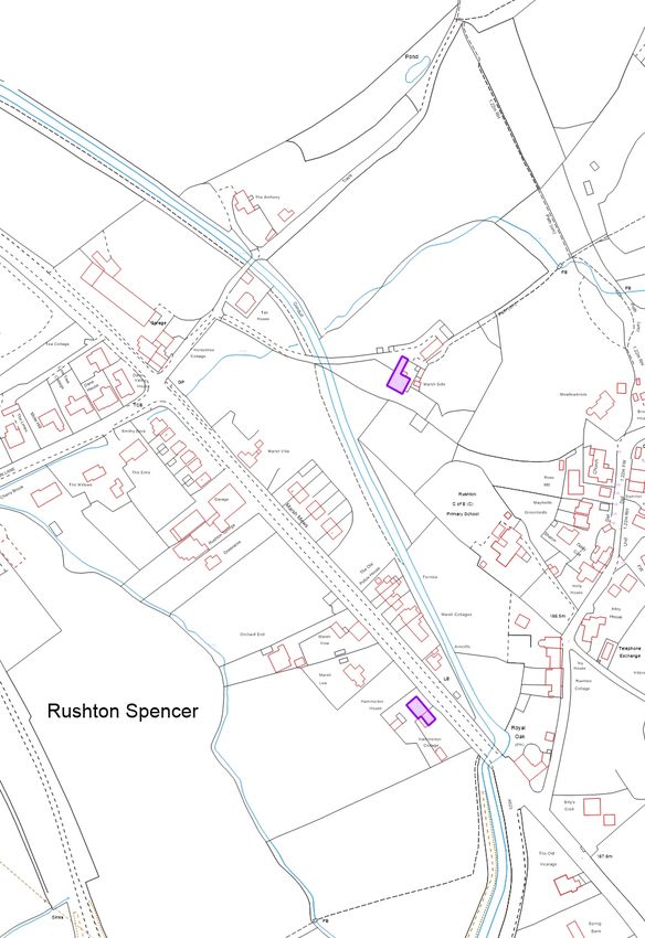
Location Land adjacent Marsh Villa, Macclesfield Road, Rushton Spencer
Proposal Application for outline planning permission for a residential
development of up to 9 dwellings with all matters reserved.
Applicant Amos Group Ltd., Ashbourne
Agent N/A
Parish/ward Rushton Date registered 23rd April 2020
/ Horton
If you have a question about this report please contact: Arne Swithenbank
tel: 01538 395578 or e-mail arne.swithenbank@staffsmoorlands.gov.uk
REFERRAL
The application is in outline (Minor) and is referred to Committee because of
the level of local interest.
1. SUMMARY OF RECOMMENDATION
Refuse
2. DESCRIPTION OF THE SITE AND ITS SURROUNDINGS
2.1 The application defines two proposed development areas within
separate red edged locations within the overall land ownership. The land is in
planning terms agricultural though it seems likely it has been little used for a
number of years. The land is owned in association with Marsh Villa, a
previously altered and extended detached stone dwelling by the roadside which
has been present at least since 1887. In summer 2020 some of the land closer
to Marsh Villa was being kept mown and enjoyed informally as ancillary
amenity to the dwelling. The remainder and majority of the grassland of the site
has become semi-wild with a varied age structure and species composition
made more diverse due to being in a low-lying and, in part at least, poorly
drained location.
2.2 The embankment of the historic former feeder canal linking the River
Dane to Rudyard Reservoir and dating from c.1809 lies along the easterly
border of the land. A public footpath runs along the top of the embankment
with generally open views across the application land. Site boundaries with
Macclesfield Road to the SW site edge are generally native broad-leaved
hedgerows. At the northern end of the application land a distinct brook course
Page 25forms the site boundary. There are occasional mature trees and shrubs to the
site peripheries and more particularly in close adjacent land.
2.3 Within 50m to the east of the application land is the unconnected
Marsh Side, an early 19thC Grade II Listed Building.
2.4 A recent brick terrace of three pairs of semis (Marsh Mews) emulating
a traditional design style and built as local need housing following a 2009
consent flanks Macclesfield Road between Marsh Villa and the southerly of the
two sites forming this application. To the south again are further terraced
dwellings addressing the road, the first being ‘The Old Police House. Opposite
the northerly of the two development sites of this application, closer to Station
Lane are a row of later 20thC detached modern houses, nos. 1 to 5 Smithy
Fold. Tan House and Horse Cottage are lone detached dwellings beyond the
application site to the north.
2.5 An “existing package treatment works” [for foul drainage] is identified
on the submitted drawings within the southerly of the two sites.
3. DESCRIPTION OF THE PROPOSAL
3.1 The proposal is in outline with all matters reserved but in response to
objections from the Highways Officer revised plans have been submitted to
show on an indicative basis how visibility splays for access points could be
formed. An original access into Marsh Villa would be brought back into use to
serve Marsh Villa and the new development would be served via a newer
access more-or-less as existing further to the north of Marsh Villa.
3.2 The total number of dwellings proposed is nine. The more northerly of
the two red edged site areas of the application extends to 3,250m2 or 0.3ha
(0.74 acres). The existing dwelling of Marsh Villa is included within this red
edge and the indicative drawings suggest five new detached dwellings between
Marsh Villa and the brook course to the north.
3.3 The smaller more southerly of the two red edged site areas measures
1,150m2 or 0.1ha (0.05 acres). The indicative drawings suggest four dwellings
laid out as two pairs of semis addressing the road and sharing a single access
point to the road. Total site area c. 4,400m2 or 0.44 ha (c.1acre).
3.4 The application is accompanied by:
highways technical note rev A (August 2020);
drainage strategy technical note (August 2020);
drainage strategy technical note (August 2020);
storm water calculations rev 2 (2nd October 2020)
drainage strategy layout plan (2nd October 2020)
preliminary ecology appraisal (surveyed October 2018);
tree survey
planning statement
Page 26 Energy and sustainability statement
3.5 The application, the details attached to it, including the plans, any
comments made by residents and the responses of consultees can be found on
the Council’s website at:
http://publicaccess.staffsmoorlands.gov.uk/portal/servlets/ApplicationSearchSer
vlet?PKID=134544.
3.6 The “existing package treatment works” [for foul drainage] identified on
the submitted drawings within the southerly of the two sites is proposed to be
re-located within the southerly site with onward outfall drainage to the north
west and ultimately to the brook under the road to Station Lane.
4. RELEVANT PLANNING HISTORY
89/00010/OLD – NW of Marsh Villa – site for the erection of pair of semi-
detached dwellings – refused
08/01136/FUL_MJ – Affordable housing development of 17 dwellings, new
vehicular access to highway and foul and surface water drainage scheme –
refused
09/00643/FUL – Erection of six houses for local need, construction of vehicular
access and construction of water treatment – approved [Marsh Mews]
12/00141/REM_1 – Variations of Conditions 4 (Landscaping), 6 (Means of
Enclosure) and 18 (Access Drives) to regularise works carried out on site –
approved [Marsh Mews]
[Sugar Street] 12/00364/OUT Outline application for residential development
(with details of access and layout) including partial demolition of existing cottage
and garage – refused – allowed on appeal
[Sugar Street] SMD/2016/0015 Details of reserved matters application for
appearance, landscaping and scale for residential development comprising 9
dwellings, including partial demolition of the existing cottage and garage
pursuant to outline planning permission SMD/2012/0155 allowed on appeal –
approved
[Sugar Street] SMD/2020/0666 Variation of conditions 2 and 5 relating to
SMD/2016/0015 – refused
[field rear of Jim Hallam garage] SMD/2018/0537 Outline application with details
of access (all other matters reserved) for the erection of up to 9 dwellings –
refused
Page 275. PLANNING POLICIES RELEVANT TO THE DECISION
5.1 The development plan comprises the adopted Staffordshire Moorlands
Local Plan and associated documentation.
Local Plan (adopted 9th September 2020)
SS1 Development Principles
SS9 Smaller Villages Area Strategy
SS10 Other Rural Areas Area Strategy
DC1 Design Considerations
DC2 The Historic Environment
DC3 Landscape and Settlement Setting
H1 New Housing Development
NE1 Biodiversity and Geological Resources
NE 2 Trees, Woodland and Hedgerows
T1 Development and Sustainable Transport
National Planning Policy Framework February 2019
Paragraph(s) 1 – 14;
Section(s) 4 – Decision making; 6 – Building a strong and competitive economy; 11 –
Making effective use of land; 12 – Achieving well designed places; 15 – Conserving
and enhancing the natural environment; 16 – Conserving and enhancing the historic
environment.
Adopted Supplementary Planning Documents/Guidance (SPD/G):
• Space About Dwellings SPG
• Design Principles SPG
• Design Guide SPD adopted 21st February 2018
Local Plan Supporting Evidence Documents:
• Landscape and Settlement Character Assessment (2008)
6. CONSULTATIONS CARRIED OUT
Public
6.1 Neighbour consultations x 8 for response by 21st May 2020. Site notice posted
20th May 2020 for responses by 10th June 2020. Press advertisement 13th May
for responses by 3rd June 2020.
– objections from 13 raising the following:
History of conflict for neighbours over Marsh Mews by this same
applicant – especially regarding drainage – “it is not called The
Marsh for nothing”
Marsh Mews not built as approved but then addressed
retrospectively
Currently there are now drainage problems with the Ivy House
development off Sugar Street
The village is already ‘over-developed’
There aren’t the amenities for further housing
Bus service very limited
Page 28 Highway safety – too many access points too close together
Already evidently a high risk section of road with 30mph limit being
proposed
Construction traffic congestion
No local need for 9 new units
This developer started by applying for 17 but got 6 – this is
development by stealth
Rushton Spencer is a smaller village with poor services
This doesn’t fit with SMDC’s carbon neutral agenda
Harm to the village landscape and character
Visually prominent site from the road and from footpaths
For the Old Police House [adjacent south end]: loss of light to
garden; loss of privacy; will be overlooked; loss of view; added risk
of flash flooding
The associated additional traffic will mean more air pollution and
traffic noise in the village
Inadequate pedestrian safety – no crossings
Loss of wild animal habitat and biodiversity
loss of trees and shrubs
No mains sewer or drains
Must not allow more pollution to the feeder canal – smells noticed
Public consultation during lockdown is a disadvantage for
residents wishing to respond
Conflict with busy Station Lane junction and the proposed access
to the seven [sic] dwellings
The 4 at the southern end are on marshland with a history of
contamination from old septic tanks
and the land also serves as a soakaway for the school drains
running under the feeder canal
site area is at the heart of the United Utilities Safeguard Zone and
they need to be consulted as outflows from the sites would enter
the brook going directly to the UU boreholes on Station Lane
The road opening to the northern development used at present by
Marsh Villa was conditional on the narrow space beside Marsh
Villa being closed off.
Plans deceptive as not to scale [LPA has checked and not found
evidence for this point]
Questions drainage practicalities in the scheme submitted
Urbanising effect eg on the footpath along the feeder
Adverse to biodiversity and survey conducted in late October two
years previously is not reliable
The land under northern site needs analysis as the developer
tipped rubble and soil here when making a yard for the Marsh
Mews development after the old hedgerow was removed. The
hedgerow along the north-east bordering the drive to Marshside
Farm, a grade 2 listed building, needs a preservation order.
The proposal is overdevelopment on agricultural land outside the
village development boundary, goes well beyond limited infill and
creates hazards for traffic on a major road on marshy land with a
Page 29You can also read