Identification of High-level Infrastructure Interdependencies for the Lower Thames Crossing - UCL Discovery
←
→
Page content transcription
If your browser does not render page correctly, please read the page content below
Identification of High-level Infrastructure Interdependencies for the Lower Thames Crossing
Case Study Report for Infrastructure UK
Final Report Published 30th October 2014

Investigation into the Development of a Framework for the
Identification and Appraisal of Infrastructure Interdependencies
with Application to Critical UK Infrastructure:
Case Study Report for Infrastructure UK.

Identification of High-level
Infrastructure Interdependencies
for the Lower Thames Crossing

Final Report Published 30th October 2014
DOI: 10.14324/20141455371

This report is delivered under the Terms and Conditions of HM Treasury Contract HMT 1055
(University of Bristol Contract Ref 42523)
Identification of High-level Infrastructure Interdependencies for the Lower Thames Crossing
Case Study Report for Infrastructure UK
Final Report Published 30th October 2014

Report Author
Dr Neil Carhart, Research Associate, Systems Centre & Department of Civil Engineering, University of
Bristol, Bristol BS8 1TR, United Kingdom. (Email: neil.carhart@bristol.ac.uk).

Acknowledgement
This report comprises a case study for a programme of research entitled ‘The Development
of a Framework for the Identification and Appraisal of Infrastructure Interdependencies with
Application to Critical UK Infrastructure’, completed on behalf of Infrastructure UK. The
research was led Prof. Brian Collins1 and Prof. Patrick Godfrey2 as Principal Investigators, and
was funded by Infrastructure UK, University College London and the University of Bristol. The
author would like to acknowledge the additional contribution of The Bartlett Faculty of the Built
Environment at UCL to this case study report, and is grateful to the International Centre for
Infrastructure Futures for publishing the final report.

Disclaimer
This report comprises a review of publicly available documents relating to the proposed Lower
Thames Crossing conducted by The Systems Centre, University of Bristol. The views and
recommendations expressed in this report are solely those of the author and do not represent
Government policy.

1   Professor of Engineering Policy, UCL; Director, International Centre for Infrastructure Futures (ICIF).
2   Professor of Systems Engineering; Director of the Systems Centre, University of Bristol.

                                                                                                          2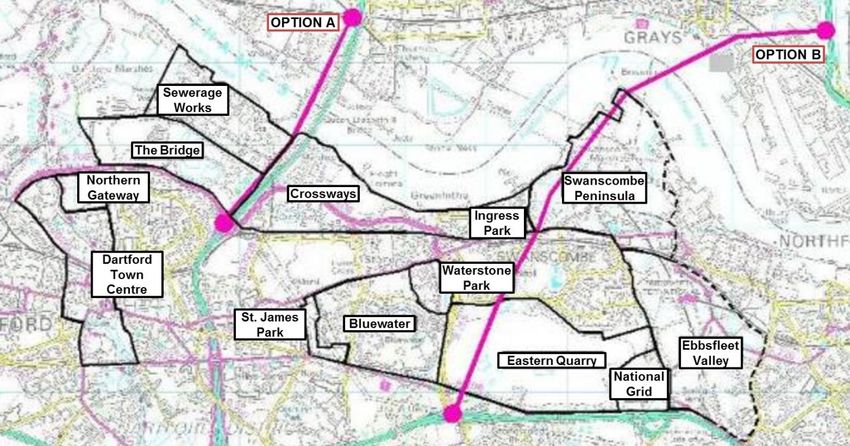
Identification of High-level Infrastructure Interdependencies for the Lower Thames Crossing
Case Study Report for Infrastructure UK
Final Report Published 30th October 2014

Contents
1            Executive Summary ................................................................................................ 5
2            Introduction ............................................................................................................. 7
3            The Lower Thames Crossing................................................................................... 8
             Purpose of the Lower Thames Crossing .................................................................. 9
             Location Options ................................................................................................... 20
             Current Project Position......................................................................................... 22
             Conclusions........................................................................................................... 22
4            Local and Regional Infrastructure and Regeneration Projects ............................... 24
             Regeneration Projects ........................................................................................... 25
             General Needs, Issues and Plans ......................................................................... 25
             Conclusions........................................................................................................... 38
5            Previously Identified Interdependencies ................................................................ 39
6            Key Stakeholders .................................................................................................. 42
7            Resonance of OMEGA Lessons and Case Study Findings to LTC Project ............ 45
8            Method for Application of IP&MF Associated Tools .............................................. 54
             Matrix-Based Tool ................................................................................................. 54
             Characterising and Evaluating Interdependencies ................................................. 55
9            Interdependency Identification ............................................................................... 58
             Energy Infrastructure & the Lower Thames Crossing ............................................ 59
             ICT Infrastructure & the Lower Thames Crossing .................................................. 60
             Transport Infrastructure & the Lower Thames Crossing......................................... 60
             Waste Infrastructure & the Lower Thames Crossing .............................................. 61
             Water Infrastructure & the Lower Thames Crossing .............................................. 62
             The Wider Community and Environment & the Lower Thames Crossing ............... 63
             Conclusions........................................................................................................... 64
10           Interdependency Evaluation .................................................................................. 65
             Energy Infrastructure & the Lower Thames Crossing ............................................ 65
             ICT Infrastructure & the Lower Thames Crossing .................................................. 65
             Transport Infrastructure & the Lower Thames Crossing......................................... 66
             Waste Infrastructure & the Lower Thames Crossing .............................................. 66
             Water Infrastructure & the Lower Thames Crossing .............................................. 66
             The Wider Community and Environment & the Lower Thames Crossing ............... 66
11     Conclusions........................................................................................................... 71
Appendix A – Lower Thames Crossing Document Roadmap .............................................. 72
Appendix B – Desk Study Output Matrix ............................................................................. 75

                                                                                                                                       3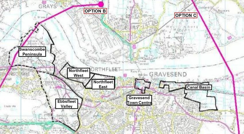
Identification of High-level Infrastructure Interdependencies for the Lower Thames Crossing
Case Study Report for Infrastructure UK
Final Report Published 30th October 2014

List of Figures
Figure 1 - The Dartford Crossing Strategic Context (Figure 1 in Jacob Babtie, 2004).......... 11
Figure 2 - 2007-2008 Dartford Road Improvements (from 2010 Atkins Transport
           Planning report) .................................................................................................. 12
Figure 3 - LTC Policy Area (from Fig 2.3 in Aecom 2013 Final Review Report)................... 17
Figure 4 - Crossing Options considered (Left: Appendix 10A of 2009 PB Study,
           Right: Figure 1.1 of 2013 Aecom Study) .............................................................. 22
Figure 5 - Kent Thameside Transport Schemes (from Figure 1-1 in 2007 Jacobs report) .... 26
Figure 6 - Conservation Areas (Figure 2.12 from 2009 MVA Study) .................................... 28
Figure 7 - Kent Thames Gateway Sub-regional Strategy Area (Diagram KTG1 in 2009
           South East Plan) ................................................................................................. 30
Figure 8 - Option A 2030 Employment Impacts (Figure 10-14 in 2009 PB Study) ............... 31
Figure 9 - Option B 2030 Employment Impacts (Figure 10-19 in 2009 PB Study) ............... 31
Figure 10 - Option C 2030 Employment Impacts (Figure 10-22 in 2009 PB study) .............. 32
Figure 11 - Key Swanscombe and Northfleet Land Use Diagram (from David Lock
            Associates, 2010) .............................................................................................. 33
Figure 12 - Development Clusters in Dartford Area (from Figure 5.1 in URS, 2012) ............ 35
Figure 13 - Development Clusters in Gravesham Area (from Fig 5.2 in URS, 2012) ........... 36
Figure 14 - Development Clusters in Thurrock Area (from Fig 5.4 in URS, 2012) ................ 36
Figure 15 - Example N-Squared Chart (after Lano, 1979) ................................................... 55
Figure 16 - Generic Sector-Level Infrastructure Interdependency Matrix ............................. 58
Figure 17 - Energy Infrastructure & LTC Interdependencies................................................ 59
Figure 18 - ICT Infrastructure & LTC Interdependencies ..................................................... 60
Figure 19 - Other Transport Infrastructure & LTC Interdependencies .................................. 61
Figure 20 - Waste Infrastructure & LTC Interdependencies ................................................. 62
Figure 21 - Water Infrastructure & LTC Interdependencies ................................................. 63
Figure 22 - Wider Society, Regeneration and Environment Infrastructure
            & LTC Interdependencies .................................................................................. 64

List of Tables
Table 1 - Aecom Appraisal Impact Areas (Table 2.1 in Aecom, 2013)................................. 19
Table 2 - Lower Thames Crossing Location Options ........................................................... 21
Table 3 - SELEP Strategic Transport Infrastructure Schemes ............................................. 34
Table 4- Average Congestion Delays by Selected Districts (seconds per vehicle km)
          with New Crossings, 2041 (Table 4.1 in 2013 Aecom study) ................................ 37
Table 5 - Main Stakeholders involved in the LTC project ..................................................... 42
Table 6 - Energy Infrastructure & LTC Interdependencies Characterisation and Evaluation 67
Table 7 - ICT Infrastructure & LTC Interdependencies Characterisation and Evaluation ..... 67
Table 8 - Other Transport Infrastructure & LTC Interdependencies Characterisation
          and Evaluation ..................................................................................................... 68
Table 9 - Waste Infrastructure & LTC Interdependencies Characterisation and Evaluation . 69
Table 10 - Water Infrastructure & LTC Interdependencies Characterisation and Evaluation 69
Table 11 - Wider Community and Environment & LTC Interdependencies
           Characterisation and Evaluation .......................................................................... 70

                                                                                                                               4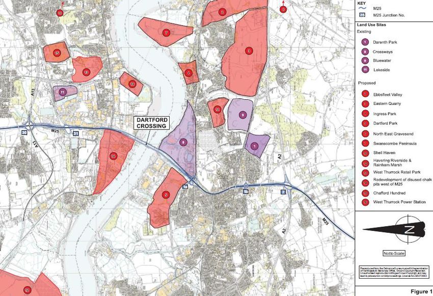
Identification of High-level Infrastructure Interdependencies for the Lower Thames Crossing
Case Study Report for Infrastructure UK
Final Report Published 30th October 2014

1 Executive Summary
Existing and planned infrastructure can be interconnected in many different ways with each
other and with the natural, political and socio-economic systems in which they are located.
Current planning, appraisal and design process for major infrastructure projects tend not to
identify and capture all of the valuable or hazardous interdependencies that could be exploited
or need to be managed. Many potential interdependencies which could deliver benefits or
costs to the project and the wider natural/social/economic/political systems are identified too
late into the process to take appropriate action.

The approach to infrastructure both old and new is often fragmented, projects are treated as
relatively closed systems and the boundaries around them are drawn too early and too narrow.
This report applies elements of an Interdependency Planning and Management Framework
(IP&MF)3 to an important emerging infrastructure project, the proposed Lower Thames
Crossing (LTC). The IP&MF, as applied here, aims to identify necessary and potential
interdependencies between the LTC and other infrastructure in order to evaluate any
prospective benefits or hazards they may present.

The existing Dartford to Thurrock Thames River crossing is an important part of the national,
regional and local road networks. Studies have found that during peak times the existing
crossing can act as a bottleneck in the network, and traffic forecasts have indicated a need for
increased future river crossing capacity in the region and as such the National Infrastructure
Plan 2012 has identified the LTC as one of 40 projects of national significance.

There are many complex issues surrounding the capacity problem, the needs for a new
crossing and delivery of a solution. The literature concerning the LTC indicates that it is
broadly conceived as a transport problem; albeit one that can influence regional and national
economies. This perspective can influence the way in which a solution is developed and the
way in which interdependencies with other infrastructure systems are identified and valued.

There are a large number of urban regeneration projects proposed for the area around the
LTC. These can have an impact on the need for a new crossing and the demands that will be
placed upon it. In turn, the existing and new crossing can impact on the delivery and success
of these regeneration activities. Desirable and undesirable interdependencies may emerge
between the LTC project and these regeneration projects either by design or by accident. The
IP&MF is applied here to better understand the potential interdependencies.

The application of a Matrix-Based Tool for the systematic identification of cross-sector
interdependencies highlights a number of necessary and potential interdependencies. These
can then be evaluated in terms of Political, Environmental, Social, Technological and
Economic factors. Additional, potentially valuable interdependency opportunities include:

3 Rosenberg, G; Carhart, N; Edkins, AJ; Ward, J; (2014), Development of a Proposed
Interdependency Planning and Management Framework. International Centre for Infrastructure
Futures: London, UK. http://dx.doi.org/10.14324/20141455020

                                                                                              5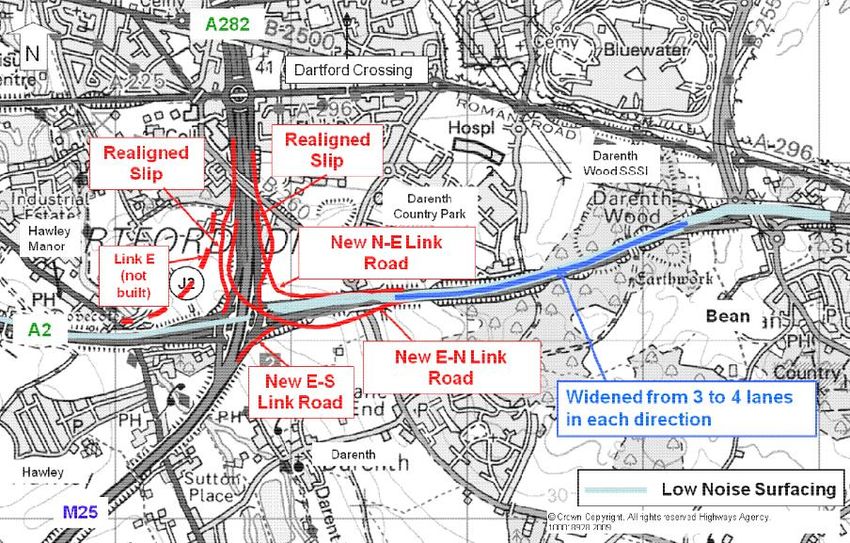
Identification of High-level Infrastructure Interdependencies for the Lower Thames Crossing
Case Study Report for Infrastructure UK
Final Report Published 30th October 2014
Using the crossing to generate electricity;
Using the crossing to carry electricity, telecommunications, water and waste
infrastructure elements;
Using the crossing as a flood defence;
Using recycled materials in the construction of the crossing; and
Sharing resources between the construction of the crossing and local regeneration
projects.
6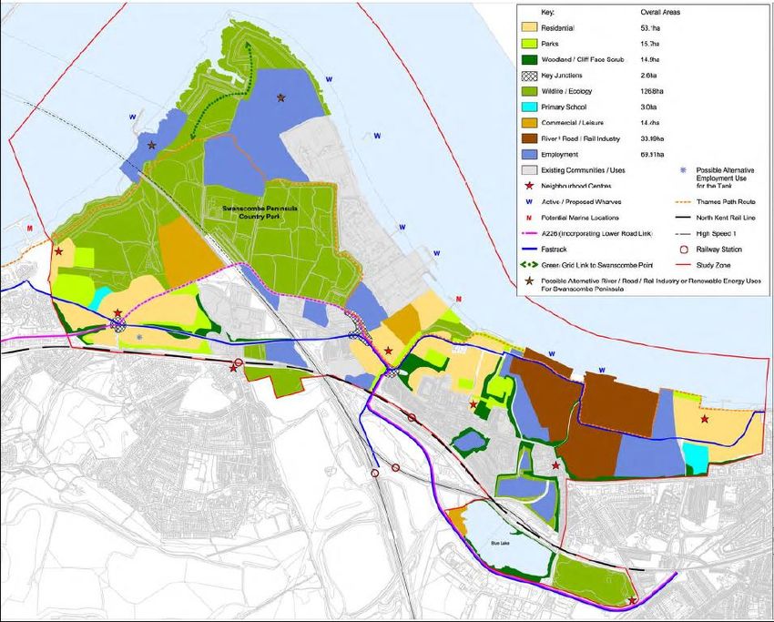
Identification of High-level Infrastructure Interdependencies for the Lower Thames Crossing
Case Study Report for Infrastructure UK
Final Report Published 30th October 2014
2 Introduction
This report explores the interdependencies between the proposed Lower Thames Crossing
(LTC) and other local, regional and national infrastructure (both existing legacy infrastructure
and planned future infrastructure). This will help in the ongoing planning and management of
the LTC infrastructure project.
It applies element of an Interdependency Planning and Management Framework (IP&MF) for
the identification and appraisal of infrastructure interdependencies. This is currently under
development by the University of Bristol (UoB) and University College London (UCL). This
wok was commissioned by HM Treasury and Infrastructure UK who identified the proposed
Lower Thames Crossing project as a suitable Case Study for the development of the
framework.
This report has several aims:
To examine the available documents relating to the proposed Lower Thames Crossing
and extract the identified characteristics, purpose, need and issues;
To examine the available documents relating to the desired regeneration of the
geographical areas arround the proposed sites for the new Lower Thames Crossing;
To identify the main Lower Thames Crossing stakeholders;
To apply the IP&MF Matrix-Based Tool in order to systematically identify and catalogue
the existing and postential interdependencies between the proposed Lower Thames
Crossing and other infrastructures, in particular other infrastructure projects; and
To evaluate the identified interdepdnencies using the IP&MF PESTLE-based
assessment method.
This report does not assess the strength of the case for a Lower Thames Crossing, nor does
it provide an appraisal of the potential crossing options. It does not evaluate or pass judgement
on the options in terms of their ability to reduce congestion on the local, regional or national
strategic road networks, their environmental impacts, social impacts, economic impacts or
their regenerative abilities These assessments have been considered elsewhere and are
described here only in the context of fully understanding the potential interdependency risks
and opportunities presented by a new Lower Thames Crossing.
The following chapter review the relevant literature surrounding the Lower Thames Crossing.
It attempts to identify the way in which the problem has been defined and the way in which it
is perceived. It looks at the implied and defined purpose of the LTC and the proposed
solutions. The third chapter looks at the proposed local and regional regeneration schemes
and the wider social and environmental context for the existing and new crossing. These are
considered in relation to the LTC. The interdependencies already identified in the literature
and the relevant stakeholders are then described in chapters four and five respectively.
Chapter six looks at the LTC project in regards to the OMEGA Lessons derived from a set of
OMEGA studies into Mega Transport Projects (MTPs).
Chapter seven sets out the method for the application of the IP&MF and it associated tools for
this case study, while chapters eight and nine describe the output of this application. Finally
chapter ten draws together a number of conclusions from this study.
7
Identification of High-level Infrastructure Interdependencies for the Lower Thames Crossing
Case Study Report for Infrastructure UK
Final Report Published 30th October 2014

3 The Lower Thames Crossing
The existing Dartford to Thurrock Thames River crossing is an important part of the national
road network. It is also of regional and local importance. The existing crossing links
international ports, major distribution centres and large urban areas. The crossing, comprising
two tunnels (opened in 1963 and 1972) and a cable-stayed bridge (opened in 1991) links the
North and South as part of the M25 (via the A282).

In 2002 it was recommended that further consideration be given to an additional multi-modal
Lower Thames Crossing4. This was endorsed by the Secretary of State for Transport who
initiated work re-examining the case.

The National Infrastructure Plan 20125 sets out 40 projects and programmes of national
significance, the focus on deliver communicated in this plan has resulted in a commitment to
build a new crossing. Pressures at Junction 30 of the M25 and on the A13 corridor will also
be considered as part of the investigation into a new crossing. The focus on infrastructure
has also cemented support for the development of the new London Gateway Port which is
also of great importance to the existing and potential new Lower Thames Crossing (LTC).

During peak times the existing crossing can act as a bottle neck in the network6. This is of
particular concern in an area forecast to experience significant economic growth, home to the
current Purfleet, Tilbury and Sheerness Ports as well as the proposed London Gateway Port.
Despite this, figures actually show a 6-7% drop in traffic using the existing crossing between
2003 and 2008, made up of a 9-10% drop in light vehicles, but an 11-12% increase in HGVs6.
This demonstrates the impact from freight traffic, the importance of the new port developments
in the area, and the related effects on local personal/business travel. The cost of delays at
the exiting Dartford crossing has been estimated to be in the region of £40 million per annum6.

This chapter summarises the main studies looking at reducing congestion on the existing
Dartford crossing and the potential construction of a new Lower Thames Crossing. The first
section identifies the issues, perceived needs and purpose ascribed to the LTC. This is
followed by a summary of the potential options for fulfilling this purpose, including locations for
a new LTC.

There are many complex and interacting issues involved in assessing the need for and impact
of a new crossing as detailed in the documents referenced here. This chapter, along with the
following chapter, focuses on the main issues specifically in relation to the interaction and
interdependency between a new LTC and other infrastructure elements and projects.

4 Kellogg, Brown & Root Ltd, 2002, Orbit: Transport solutions around London, A report for The
Government Office for the South East
5 HM Treasury & Infrastructure UK, 2012, National Infrastructure Plan 2012
6 Parsons Brinkerhoff, 2009, Dartford River Crossing Study, Parsons Brinkerhoff for Depart for

Transport

                                                                                                 8
Identification of High-level Infrastructure Interdependencies for the Lower Thames Crossing
Case Study Report for Infrastructure UK
Final Report Published 30th October 2014
Purpose of the Lower Thames Crossing
A number of studies have been conducted to understand the need and therefore purpose for
a Lower Thames Crossing. These have also examined the wider issues affecting the project.
A list of these documents can be found in Appendix A.
Consideration of a new Lower Thames Crossing essential began in 1990 when a report by the
Department for Transport entitled ‘Private Finance Road Schemes – Information on
Proposed Options’ described how a it could:
“increase the opportunity for journeys between Kent and Essex downstream of the
Dartford Crossing”;
“improve communications between the fast growing areas of East Anglia and Essex
and Kent”;
“and for traffic bound for the Continent via the Channel Tunnel or the Haven Ports”;
and
“would assist M25 in dealing with orbital traffic in this sector”
This led to a 1994 report by G. Maunsell and Partners (later acquired by Aecom) which
included a Feasibility Study into the LTC for the Highways Agency. It identified four potential
crossing locations: Swanscombe, Tilbury, Canvey and Sheerness.
Variations at these four locations resulted in a total of 25 different possible routes. The report
concluded that a new Lower Thames Crossing would:
Reduce congestion on the existing Dartford crossing, including the approaches to the
north and south;
Promote economic and development opportunities;
In addition to this, it made some location specific conclusions:
A crossing at Swanscombe or Tilbury would influence a relatively large area of
development;
Swanscombe would not provide the same user benefits as the other locations;
A crossing at Tilbury would integrate with existing highway proposals and improve the
strategic network, and;
A crossing at Tilbury is the only location that would be financially viable, and may be
privately fundable.
The 1998 Dartford Local Crossing Study by Halcrow Fox and Associates again
investigated the feasibility of a new crossing in the Dartford area.
Following the 1998 ‘New Deal for Transport’, the Orbit Multi Modal Study was conducted
in 2002. This aimed to develop a long-term sustainable management strategy for the M25
which meets the Government’s transport objectives and resolves or relieves current and future
problems. It sets out a specific area objective to:
“Examine the role of additional road and rail cross-river capacity east of Dartford
to assist regeneration and improve accessibility in Thames Gateway, particularly
for freight movement.”
It identifies the existing Dartford crossing as one of four particularly congested areas,
assessing it in more detail they add:
“Where there is no satisfactory public transport alternative, particularly at the
Dartford crossing, then the level of social exclusion is even more of a concern”
9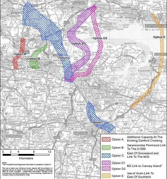
Identification of High-level Infrastructure Interdependencies for the Lower Thames Crossing
Case Study Report for Infrastructure UK
Final Report Published 30th October 2014
As it is the only crossing for some distance, it is described as being “inelastic” to tolls It also
notes lack of real-time information, local bans on night-time freight movement and single
occupancy cars as increasing the problem of congestion on the M25. The Orbit report quotes
Highways Agency figures (in Table 12.1, p152) that conclude the Dartford Crossing itself will
reach capacity in less than 10 years (i.e. by 2012) while some of the surrounding junctions will
reach capacity before then. It summarises the main conclusions of the pre-2002
investigations, stating that the LTC:
would reduce traffic congestion on North and South approaches to the existing Dartford
crossing, reducing bottlenecks at points of strategic importance to freight;
could promote development;
would provide local and international freight to by-pass London and connect to the
national road network; and
would provide better links between Europe and UK cities.
The study concludes that an initial economic appraisal suggests a new crossing would have
a low benefit to cost ratio, adding:
“We believe that a new Lower Thames Crossing should be seen as a local facility
to aid regeneration in the Thames Gateway and not primarily as a means of
relieving the M25.”
Ultimately, further investigation into the LTC is recommended by the study on the grounds it
would relieve M25 congestion and aid regeneration in the Thames Gateway. They do not rule
out rail infrastructure being part of the crossing to ease difficulties with rail freight
circumnavigating London.
Jacobs Babtie produced a report at the end of 2004 for the Highways Agency entitled
‘Getting the most out of the Dartford Crossing’. It concludes that possible future demand
pressures on the crossing may arise from improvement measures adjacent to the crossing;
national, regional and local regeneration plans; M25 Motorway policies, and; tunnel safety and
air quality legislation and EU directives. It quotes data from October 2003 that 61% of journeys
using the crossing are longer than 100km.
It uses data from the Highways Agency’s NAOMI traffic model (which include assumptions
about provision from the DLR extension, Thames Gateway Bridge, Crossrail and the CTRL)
to predict a more than 20% increase in daily flows by 2016. This is equal to the highest ever
throughput measured at the time on two occasions in 2004. It notes that these were marked
by congestion for 14 hours of the day and therefore predicts this to become a common
occurrence by 2016. It concludes from this data that:
“the existing Dartford Crossing and its approaches will be unable to accommodate
the NAOMI predicted demand without extensive congestion and frequent
demands for significant improvement”.
As a result the levels of service for the M25 would not be achieved, a greater proportion of
freight than originally identified would need to move to alternative modes or overnight
movement and the demand for movement and regeneration opportunities will be “frustrated
by a lack of capacity”.
It investigates short and medium term proposals such as removing the southbound toll plaza
and changes to charging but ultimately suggests that “It would appear timely to examine
further both the engineering practicality and full business case for significant enhancement to
10Identification of High-level Infrastructure Interdependencies for the Lower Thames Crossing
Case Study Report for Infrastructure UK
Final Report Published 30th October 2014
the Crossing that will match the inherent capacity of the M25 ring” itself projected to increase
as a result of a Rapid Widening Project.
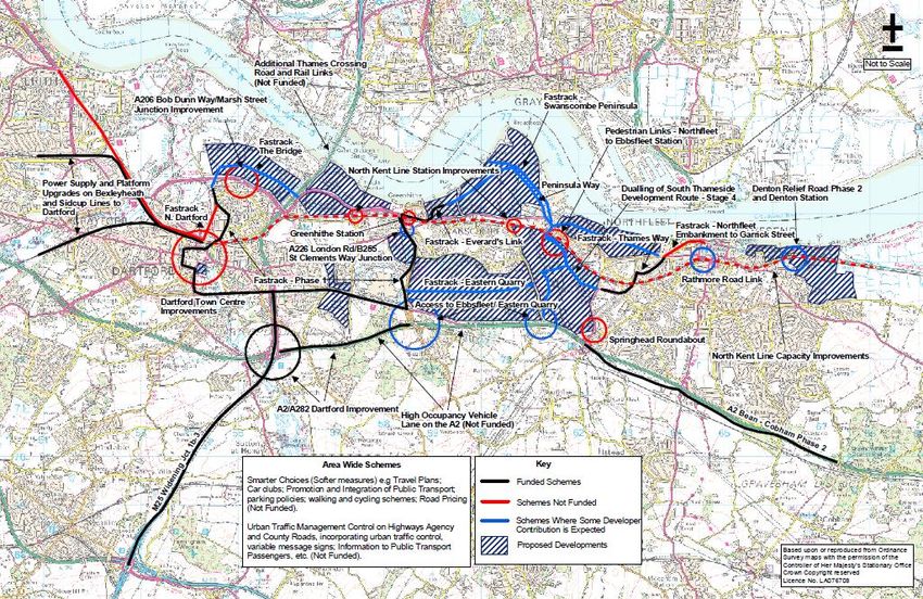
The report places the crossing into the wider context of the area (Figure 1), the developments
within which are discussed further in the following chapter.
Figure 1 - The Dartford Crossing Strategic Context (Figure 1 in Jacob Babtie, 2004)
Their assessment of 13 different measures for dealing with the predicted growth in congestion
concludes that none will have a significant impact in the short term, though some may limit
disruptions due to accidents.
They also note that the crossing is part of the local and regional road network, that its
importance in this context is likely to increase (due to increased housing, employment and
business developments), and that this will have an impact on congestion and journey time
reliability which will ultimately impact the local and national economy. Furthermore, they
recognise that opportunities to safeguard land for a new crossing are shrinking as the
regeneration of the region continues.
In December 2007 a set of improvements to the A2/A282, on the south approach to the
existing crossing, were opened. This involved the construction of three free-flow links at J2 of
the M25 and the widening of 2km of the A2 to the east of the junction. Part of the objectives
of this was to reduce journey times, improve reliability and improve access to the regeneration
local areas. In July 2008 widening of Junction 1b to Junction 3 of the M25 was opened. This
too aimed to improve journey time and reliability, as well as creating jobs in the area through
11Identification of High-level Infrastructure Interdependencies for the Lower Thames Crossing
Case Study Report for Infrastructure UK
Final Report Published 30th October 2014
increased labour markets. Figure 2 taken from a post project review by Atkins Transport
Planning7 depicts these improvements.
Figure 2 - 2007-2008 Dartford Road Improvements (from 2010 Atkins Transport
Planning report)
In 2008 the East of England Plan recognises the link between the Essex Thames Gateway
and the Kent Thames Gateway as being a key inter-regional infrastructure connection. Also
in 2008 the Department for Transport published ‘Delivering a Sustainable Transport System’
(DaSTS)8. This set out five high-level goals against which the options for a new Lower Thames
Crossing were assessed. These goals are:
1) to support national economic competitiveness and growth, by delivering reliable and
efficient transport networks;
2) to reduce transport’s emissions of carbon dioxide and other greenhouse gases, with
the desired outcome of tackling climate change;
3) to contribute to better safety, security and health and longer life expectancy by
reducing the risks of death, injury or illness arising from transport, and by promoting
travel modes that are beneficial to health;
4) to promote greater equality of opportunity for all citizens with the desired outcome of
achieving a fairer society; and
5) to improve quality of life for transport users and non-transport users, and to promote a
healthy natural environment.
In 2009 Parsons Brinkerhoff were commissioned by the Department for Transport to
investigate ways of addressing capacity constraints at the existing Dartford crossing6. It
looked at capacity requirements up to 2037, the role of other transport modes (e.g. rail) in
meeting the capacity demands, the impacts of meeting the demand with new infrastructure
7 Atkins Transport Planning, 2010, Post Opening Project Evaluation: A2/A282 Dartford Improvement
and M25 J1b – 3 Widening: One Year After, September 2010
8 Department for Transport, 2008, Delivering a Sustainable Transport System, November 2008
12Identification of High-level Infrastructure Interdependencies for the Lower Thames Crossing
Case Study Report for Infrastructure UK
Final Report Published 30th October 2014
and how to improve traffic flow in the short/medium term. The analysis uses data from Le
Crossing, the Dartford Crossing operators and the Highways Agency (HATRIS database).
The report identified that the “planning, economic, regional and national transport issues in
the vicinity of the existing Dartford Crossing are inextricably linked to the relevant Regional
Spatial Strategies (RSS) and the emerging Local Development Frameworks (LDF)”.
The study conducted transport modelling to establish a base case for future use of the Dartford
Crossing, assessed the current and likely future performance of the existing crossing based
on this, investigated the option of rail provision, investigated options for making better use of
the existing crossing, undertook stakeholder engagement activities and identified preliminary
designs for a possible new crossing.
Using the available data the report concludes that the existing crossing experiences “high
levels of flow and congestion on a daily basis” adding that total flows had actually decreased,
but HGV crossings had increased. The crossing experiences the third highest delays in the
strategic road network. Almost half of users in either direction experience a significantly
reduced level of services (quantified as “more than nine minutes of additional delay”). Of the
journeys using the crossing:
40% of light vehicles are journeying relatively long distance (>80km)
50-60% of light vehicles are travelling between the urban areas either side of the
crossing
30% of the HGV journeys are to or from the port of Dover over long distances
50% of the HGV journeys are centred around elsewhere in the East and South East
20% of the HGV journeys are over short distances between centres on either side.
It is certainly of interest that “There is specific evidence, drawn from the Census data, which
suggests that interactions between the local authority areas to the north and south of the
Thames on either side of the Crossing are lower than would be expected, given the proximity
of the areas.” It is suggested that as these areas grow, this disconnect could restrict
employment opportunities and therefore wider economic prosperity.
Using figures for 2007 the report calculates that the cost of the delays at the existing crossing
cot in the region of £40 million per annum (para 5.101). Demand on the existing crossing is
forecast to increase by 38% to 2031 by the East of England Model (para 7.41), assuming the
congestion would not affect this growth. The Trip End Model Presentation Program
(TEMPRO) forecasts 19% of the total number of hours in a year would see flows exceeding
the current 6,000 vehicles per hour capacity. Disruption to journey time reliability is already
seen when demand exceeds 4,000 vehicles per hour. This is projected to occur for 43% of
the available hours in a year. The South Essex Land Use and Transport Model (SETLUM)
also predicts the crossing to be beyond capacity by 2030. These projections seemingly
provide a strong case for the consideration of improved capacity management and additional
capacity.
The PB report dismissed the option for a rail crossing, identifying a lack of demand from
passengers for a North-South crossing, and a limited need for alternative freight carrying rail
infrastructure. The report concludes:
“It is acknowledged that there will be rail freight capacity issues by 2031 around
much of London. That said, the inclusion of rail freight provision as part of any new
13Identification of High-level Infrastructure Interdependencies for the Lower Thames Crossing
Case Study Report for Infrastructure UK
Final Report Published 30th October 2014
Lower Thames Crossing would not appear to address these issues and may even
lead to a deterioration in rail congestion at certain points in the network.”
Adding:
“Overall, taking into account both passenger and freight provision, the inclusion of
rail infrastructure within the scheme is not considered to have a reasonable initial
business case.”
The consultation highlighted two constraints perceived to be of particular importance by the
stakeholders:
The issue is more to do with a general infrastructure deficit than a specific crossing
constraint
The need for a new crossing was frequently linked to the challenges created by the
existing crossing
The conclusions strongly link the need for providing additional river-crossing capacity to the
economic growth of the region:
“It is therefore reasonable to assume that without cross-Thames capacity
enhancements in the Lower Thames area, increased delays resulting from
forecast increases in demand within the study area will have several effects. It will
not only worsen journey time reliability but will also generate negative economic
effects at local, regional and national scales as well as more localised social
impacts.”
In terms of rail freight, the Parsons Brinkerhoff study looks at the ‘Great Britain Freight Model’
forecasts up to 2031. These forecasts suggest there would be minimal growth in the areas
served by a new crossing in the Lower Thames region, and little scope for modal shift away
from road freight. It would not serve the routes forecast to experience significant growth. They
conclude that “Overall, taking into account both passenger and freight provision, the inclusion
of rail infrastructure within the scheme is not considered to have a reasonable initial business
case.” The inclusion of a freight crossing was therefore discounted from the options
considered in the study. There is of course an argument that 2031 timescales may be too
short for such an infrastructure investment.
Parsons Brinkerhoff identified five potential location options (referred to as A. B, C, D and E,
as described in Table 2 below) which were assessed with respect to the DaSTS goals in terms
of their corridor description and alignment, their traffic impacts, their wider economic benefits,
their environmental impacts, their integration and accessibility with other transport
infrastructure, and stakeholders views. The integration of the LTC with other transport
infrastructure relates mainly to the SERT and Fastrack Bus Rapid Transport schemes, along
with cycling and pedestrian facilities.
While these options are described in greater detail in the following section, it is of note that
two potential crossing sites (D and E) were recommended for elimination from further
consideration. Option D performed generally positively against the DaSTS goals, but
significantly worse than Options A, B and C. It would benefit the London Gateway Port and
local traffic movements but would provide limited relief to the existing Dartford Crossing,
leaving it over capacity, increasing greenhouse gas emissions compared to the ‘do nothing’
case, and causing significant adverse environmental impacts. Option E would also provide
only limited relief to the existing crossing, again leaving it over capacity and ultimately
14Identification of High-level Infrastructure Interdependencies for the Lower Thames Crossing
Case Study Report for Infrastructure UK
Final Report Published 30th October 2014
increasing greenhouse gas emissions. It is also a site forecast to experience only a low level
of traffic demand.
Also in 2009 the Gifford, MVA Consultancy and Capita Study9 sought to help the Essex
and Kent County Councils to better understand how additional crossing capacity might change
land use on either side of the estuary and how it might bring economic regeneration into the
area.
Phase 1 of this report looks at the need for intervention, identifying two points:
A need to improve the level of reliability and dependability of journey times across the
river for European (TEN-T), national and local traffic
A need to improve the connectivity between the growth areas in North Kent and South
Essex
The regeneration plan for these areas identify the need for and benefit of a new crossing, “but
currently the plans are predicated only on the exiting Dartford – Thurrock Crossing”. The
potential is to unlock additional benefits and to further facilitate growth.
They state that “Any intervention will need to facilitate the achievement of the planning
objectives relating to the economic, environmental, social and employment needs of the area”
adding that it should also facilitate other improvements that would reduce the effect of traffic
and benefit the community. To this end, they identify six requirements for a new crossing
extending the two points above:
To reduce congestion and improve the reliability and dependability of journey times;
To ease local traffic congestion and associated problems;
To result in a safer and more efficient corridor;
To cater for future planned growth;
To assist in enabling future regeneration and economic growth;
To support public transport and other sustainable modes.
The study looked at nine possible locations, considering the feasibility of bridges and tunnels
at each. Each option was appraised based on congestion relief, economic vitality,
environmental impact, engineering (feasibility, acceptability and impact on existing network),
affordability (capital costs and funding sources), enabling of development and regeneration
and travel sustainability (e.g. promoting sustainable transport modes, share of sustainable
modes, improving safety and reducing demand).
In term of reducing congestion alone, their modelling indicates that a crossing between West
Thurrock and Swanscombe would be the best option, followed by the Grays to Swanscombe
option (similar to Option B in the PB study), Chadwell to Gravesend option (similar to Option
C in the PB study) and Wennington to Dartford option.
In 2010 KPMG produced a report10 for Kent County Council into the Lower Thames Crossing.
This looked at potential funding options for the project along with the likely regeneration
impacts. It underlined this link between the crossing and regeneration concluding productivity
benefits of £2 and £15 million per annum depending on the chosen location. Importantly, it
9 Gifford, MVA Consulting and Capita, 2009, Assessment of Lower Thames Crossing Capacity,
November 2009
10 KPMG, The Lower Thames Crossing – KPMG Regeneration and Funding Report, August 2010
15Identification of High-level Infrastructure Interdependencies for the Lower Thames Crossing
Case Study Report for Infrastructure UK
Final Report Published 30th October 2014
indicates that Kent County Council has concluded that a crossing between Stanford-le-Hope
and the East of Gravesham (known as Option C) is its preferred route.
The existing Dartford Crossing is beyond the boundary of the Greater London area, but as
part of the Strategic Road Network and a by-pass to central London, its efficiency can have a
significant impact on the city. In May 2010 the Mayor’s Transport Strategy for London for
the period up to 2031 states in Proposal 39 f) “Support for Government proposals to reduce
congestion at the Dartford crossing”.
This was followed by the London Plan published in July 2011 by the Greater London
Authority reiterates the need for additional river crossings in the east sub-region of London
in Policy 6.4, Policy 6.12 and Table 6.1. Policy 6.4 ‘Enhancing London’s Transport
Connectivity’ is generally concerned with ensuring “effective transport policies and projects to
support the sustainable development of the London city region and the wider south east of
England” as well as “efficient and effective cross-boundary transport services”. Policy 6.4,
Part B which refers to improving the public transport system, includes (clause k) “providing
new river crossings”. Paragraph 6.20 expand on this but does not specifically mention the
Dartford Crossing or any plans to increase its capacity, the focus instead being on additional
crossings east of the existing Dartford Crossing. Policy 6.11 addresses smoothing traffic flow
and tackling congestion, while Policy 6.12 addresses road network capacity. It is stated that:
“[The Mayor] is committed to improving cross-river pedestrian, cycle and public
transport links, to promoting a shift from private cars to more sustainable modes,
and to encouraging freight journeys to avoid peak hours through improved journey
planning, supply chain measures and support for consolidation centres and modal
shift to rail and water in order to reduce pressure on congested crossings. There
will, however, continue to be a need for some journeys to be undertaken by
vehicle, in particular commercial traffic, the movement of goods and the provision
of services to support a growing economy in east London”
Here, the Dartford crossing is specifically mentioned as regularly operating at, or close to,
capacity. It is recognised as having little resilience and being important to local businesses in
south east London. The report argues that projected increases in jobs and population in the
Thames Gateway will make the situation worse, and “The Mayor is therefore supportive of
additional road-based river crossings in east London as part of a package of transport
improvements.”
On the 21st May 2013 the Government launched a consultation into location options for the
Lower Thames Crossing, supported by the release of a new review of crossing options
completed by Aecom for the Department for Transport11.
It is perhaps of note that as part of the methodology for this study (as described in para 2.5.2)
the report’s authors contacted statutory bodies responsible for environmental issues, the Port
of London Authority, Network rail and major public utilities in order to understand constraints
imposed on the various location options, particularly by their infrastructure assets.
11 Aecom, 2013, Review of Lower Thames Crossing Options: Final Review Report, April 2013
16Identification of High-level Infrastructure Interdependencies for the Lower Thames Crossing
Case Study Report for Infrastructure UK
Final Report Published 30th October 2014
The policy area, defined as “the area where the provision of new capacity at one of the location
options might have particular impacts” (para 2.7.4) is shown in the diagram below.
Figure 3 - LTC Policy Area (from Fig 2.3 in Aecom 2013 Final Review Report)
Section 3.2 describes the Business Strategy through reference to several key government
publications. In addition to the general points of the National Infrastructure Plan (facilitate
economic growth and private investment, and improve quality, sustainability and capacity), at
the highest level this refers to a vision for “dynamic, sustainable transport that drives economic
growth and competitiveness” (para 3.2.1). This is interpreted from a 2012 Department for
Transport document12. The report then references a speech from the Prime Minister in March
2012 which links transport to business investment, economic growth and protection of the
environment, and the Department for Transport Business Plan13 for investment in roads to
promote growth while reducing congestion and carbon emissions. Finally it references
Highways Agency Business Plan’s14 goals to tackle bottlenecks and increase capacity.
Section 3 sets out the Strategic Case and the need for change, summarising the problem in
para 3.3.8:
“The lack of capacity and resilience result in consequential problems: delays;
longer journey times and reduced journey time reliability. These impacts in turn
reduce business productivity and ultimately produce an adverse impact on the
national economy. A further consequence of congestion is higher vehicle
emissions, which has consequences for local air quality.”
In other words; (1) lack of capacity at the existing crossing, which causes; (2) delays in both
directions; (3) reduced resilience (i.e. higher rate of incidents that at other parts of the strategic
12 Department for Transport, 2012, The High Level Output Specification (HLOS) 2012: Railway Act
2005 Statement, July 2012
13 Department for Transport, 2011, Business Plan 2012-2015
14 Highways Agency, 2011, HA Business Plan 2012-2013
17Identification of High-level Infrastructure Interdependencies for the Lower Thames Crossing
Case Study Report for Infrastructure UK
Final Report Published 30th October 2014
road network; (4) reduced journey time reliability and; (5) reduced connectivity. In addition to
this are a number of adverse environmental impacts (primarily in terms of air quality). As
stated in the above quote, these combine to reduce productivity and economic activity. It is
therefore suggested that providing additional capacity will resolve these problems. It is
suggested that the short-term measures will not address long term traffic forecasts.
This conclusion is drawn from the supporting Aecom report into demand forecasts15 that traffic
flows will increase from 2009 to 2041 by around 30%. This prediction includes road schemes
considered likely to already be implemented by 2041. Flows across the existing Dartford
Crossing are predicted to increase by 10-20% in the southbound direction and 2-10%
in the northbound direction by 2041. Growth in the northbound direction will be constrained
by lack of capacity. The main driver for this growth is identified as the forecast increase
in population.
Having established that the need is “to add capacity to the strategic road network to alleviate
congestion at the existing crossing” Paragraph 3.5.3 outlines the way in which the impacts of
a new crossing at each of the proposed locations were judged:
“This involved considering the extent to which a new crossing at each location
would:
contribute to the national economy, through improving journey times and
connectivity of the strategic road network, both to and within the Thames
Gateway and the South East;
reduce congestion at the existing crossing and improve the resilience of the
strategic road network;
contribute to reducing greenhouse gas emissions;
avoid unacceptable impacts on environmentally sensitive areas and improve
quality of life; and
avoid unacceptable impacts on committed development. “
From this statement of need and appraisal framework it is clear that the LTC Project is firmly
conceived as a transport solution. Its benefit to the national and regional economy arises from
reducing congestion and therefore reducing journey times, improving connectivity and
reducing harmful emissions. The success of the project is to be measured through changes
in: (1) the level of delay; (2) journey times; and (3) journey time reliability. Environmental
appraisal will look to measure: (1) incidents and accidents; (2) noise and air quality; and (3)
traffic volumes.
The report claims that stakeholders are particularly concerned with the congestion and lack of
resilience of the current crossing. The Thames Gateway South Essex Partnership for
example are cited as being concerned that this may affect growth in the area, while the
Thames Gateway Strategic Group state that it is critical to Britain’s economic future. The
South East Local Enterprise Partnership (SELEP) are reported to also be very concerned
with these issues, and that they consider the LTC to be the second highest priority national
15Aecom, 2013, Review of Lower Thames Crossing Options: Central Forecasts and Sensitivity
Report. April 2013
18Identification of High-level Infrastructure Interdependencies for the Lower Thames Crossing
Case Study Report for Infrastructure UK
Final Report Published 30th October 2014
road scheme. It is also quoted that proposal 39 in the Mayor of London’s Transport Strategy16
indicates support for the Government proposals to reduce congestion at the existing crossing.
The direct impacts of the new crossing at each of the location options is carried out using the
LTC Model15. The focus is very much on the direct traffic impacts, congestion and journey
times. These are then interpreted to understand the key impacts they may have. This is done
in accordance with DfT Transport Analysis Guidance (WebTAG). The impact areas are split
into four areas with associated sub-topics, these are shown in the table below, which also
indicates whether they were monetised in the appraisal process, whether social and
distributional impacts have been analysed, and the relevant WebTAG reference.
Table 1 - Aecom Appraisal Impact Areas (Table 2.1 in Aecom, 2013)
WebTAG Unit 3.5.14 describes how wider impacts resulting from transport interventions are
a result of:
Changes in labour supply;
Move to more/less productive jobs;
Agglomeration (third party spin off benefits from businesses being brought closer
together); and
16 Greater London Authority, 2010, Mayor’s Transport Strategy, May 2010
19Identification of High-level Infrastructure Interdependencies for the Lower Thames Crossing
Case Study Report for Infrastructure UK
Final Report Published 30th October 2014
Changes in output in imperfectly competitive markets.
In each case, ‘Regeneration’ impacts are linked to the new crossing shifting employment
opportunities, while ‘Wider Impacts’ are described as the agglomeration benefits of improved
connectivity. In the appraisals ‘Access to Services’ are seemingly only interpreted as “public
transport services”, perhaps reinforcing the perceived project boundary as being a transport
project. For each of the potential locations it is noted that there would be no impact on public
transport services or access to them.
Appendix D1.26 to the Aecom report does explicitly recognise that the crossing could impact
on land use in the area, in relation to regeneration, adding that “In transport appraisal,
regeneration refers specifically to the redistribution of economic activity or employment that
results in an increase in employment” of the residents in the defined area. A means for
calculating this impact is set out in WebTAG Unit 3.5.8. However, given the complexity and
uncertainty, it was not felt appropriate to conduct a Regeneration Report consistent with
WebTAG Unit 3.5.8 (or Unit 2.8). Instead a qualitative approach is used.
It is recognised (in Table 5.2 of the Aecom report) that a risks to the Commercial Case for the
new crossing could result from “Poor integration with supporting infrastructure” leading to
increased congestion. Additionally, under the heading “Integrated Infrastructure”, the case
suggests:
“A maintenance plan could be established to minimise disruption and congestion
whilst maximising economic performance of the new crossing and supporting
infrastructure”
On a regional scale “additional capacity could only be expected to limit the economic growth
within the Thames Gateway in the future” (para 3.3.16). The LTC project is seemingly
conceived as a solution to the forecast lack of capacity at the existing Dartford Crossing, and
the follow on problems this presents. The appraisal framework described above reinforces
this view. However, there is also a strong argument for considering such large transport
projects as proactive agents for change and not just passive solutions. The LTC Project does
not appear to be perceived in this way, instead being a passive solution to a perceived barrier.
It could benefit greatly, particularly in terms of identifying and leveraging beneficial
interdependencies, from adopting a more open-systems view and being framed as a proactive
agent for change.
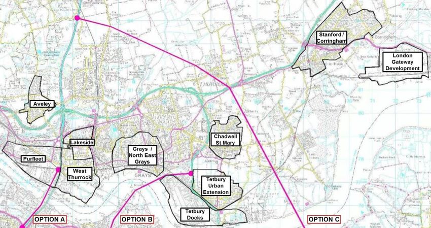
Location Options
Several locations have been considered for the Lower Thames Crossing in the studies
between 1994 and 2013. The 1994 Maunsell study looked at the feasibility of 25 different
routes, while the Gifford, MVA, Capita study in 2009 looked into 9 different locations. The
Parsons Brinkerhoff study identified 5 which were assessed and narrowed down to the 3
options taken forward to the public consultation in 2013.
For the purposes of this report, the focus will be on the three options reported in the 2013
Aecom report. These can be summarised as:
Option A – Additional capacity at the existing Dartford Crossing
Option B – New crossing at the Swanscombe Peninsula link A2 to the A1089
Option C – New crossing East of Gravesend and link to the M20
20Identification of High-level Infrastructure Interdependencies for the Lower Thames Crossing
Case Study Report for Infrastructure UK
Final Report Published 30th October 2014
For completeness, the 2009 PB report also investigated:
Option D – M2 link to Canvey Island (two variants)
Option E – Isle of Grain link to East of Southend.
These are shown in Figure 4 below, reproduced from the PB report.
Table 2 - Lower Thames Crossing Location Options
Gifford, MVA (2009) Parsons Brinkerhoff Aecom (2013)
(2009)
Wennington – Dartford
Connecting the A13 to the A206
Existing Dartford – Thurrock Option A Option A
West Thurrock –
Swanscombe
Connecting A126 to A206
Grays – Swanscombe Option B Option B
Connecting A1089 to A206(west of Connecting A1089 to A2 (west of Connecting A1089 in vicinity of
Gravesend) Gravesend) Tilbury Docks to A2 near Dartford
Chadwell – Gravesend Slight variation on Option C
Connecting A1089 to A2 (east of
Gravesend)
Stanford-le-Hope – Option C Option C
Gravesend Connecting the M25 to the M2
Connecting the A13 to A2 (east of
Gravesend)
Canvey – Grain Option D
Connecting A130 to A228 Connecting A13/A130 to the A228
Canvey – Halstow Similar to Option D location but
Private Metro tidal plan for multi- Metro tidal have also considered
modal tunnel, tidal power plant and Option E location.
flood defences
Shoeburyness – Sheerness Option E
Private plan for bridge linking man
made islands
21You can also read