PREPARED BY:
Wildfire Planning International, LLC
Wildland Professional Solutions, Inc.
←
→
Page content transcription
If your browser does not render page correctly, please read the page content below
PREPARED BY: Wildfire Planning International, LLC Wildland Professional Solutions, Inc.
The Community Planning Assistance for Wildfire (CPAW) program works with communities to
reduce wildfire risks through improved land use planning. The CPAW program is a joint
partnership between Headwaters Economics and Wildfire Planning International. It is funded by
grants from the USDA Forest Service and private foundations.

CPAW engages qualified professionals with expertise in land use planning, forestry, risk
modeling, and fire behavior. This report was produced by:
Kelly Johnston, RPF, FBAN – Wildfire Professional Solutions, Inc.
Molly Mowery, AICP – Wildfire Planning International, LLC
Additional authors and contributors included: Eva Karau – USDA Forest Service, Rocky
Mountain Research Station, Darrin Punchard, AICP – Punchard Consulting, LLC, and Hannah-
Hunt Moeller. For questions related to this report, please contact: info@wildfireplanning.com.

CPAW relies on collaboration with local stakeholders to provide meaningful feedback
throughout the process. Our team would like to thank everyone who contributed their time to our
CPAW activities in the Gunnison County community, including members of the Gunnison
County Community and Economic Development and Emergency Management departments,
Gunnison Fire Protection District, Crested Butte Fire Protection District, Colorado State Forest
Service, West Region Wildfire Council, USDA Forest Service, City of Gunnison, and Gunnison
County Board of Commissioners. Any omissions on this list are solely the responsibility of the
authors and are not intended to reflect the value of other participants.

P.O. Box 7059
Bozeman, MT 59771
https://planningforwildfire.org

Cover photo provided by CPAW.

In accordance with Federal law and the U.S. Department of Agriculture policy, this institution is prohibited from
discriminating on the basis of race, color, national origin, sex, age, or disability. (Not all prohibited bases apply to all
programs.) To file a complaint of discrimination, write USDA, Director, Office of Civil Rights, Room 326-W, Whitten
Building, 1400 Independence Avenue, SW, Washington, DC 20250-9410 or call (202) 720-5964 (voice and TDD).
USDA is an equal opportunity provider and employer.

Community Planning Assistance for Wildfire / Gunnison County / 2019 i
Community Planning Assistance for Wildfire / Gunnison County / 2019 ii
BLM Bureau of Land Management
BRIC Building Resilient Infrastructure and Communities
COT Conservation Objectives Team
COWRAP Colorado Wildfire Risk Assessment Portal
CPAW Community Planning Assistance for Wildfire
CRS Colorado Revised Statutes
CSFS Colorado State Forest Service
CWPP Community Wildfire Protection Plan
DMA Disaster Mitigation Act
DRRA Disaster Recovery Reform Act
ESA Endangered Species Act
FEMA Federal Emergency Management Agency
FMAG Fire Management Assistance Grant
FWS U.S. Fish and Wildlife Service
GNA Good Neighbor Authority
HMA Hazard Mitigation Assistance
HMGP Hazard Mitigation Grant Program
HMP Hazard Mitigation Plan
HOA Homeowner Association
ICC International Code Council
IWUIC International Code Council Wildland-Urban Interface Code
LUR Land Use Resolution
NFPA National Fire Protection Association
PDM Pre-Disaster Mitigation
RMRS Rocky Mountain Research Station
SIZ Structure Ignition Zone
SME Subject Matter Expert
SRS Secure Rural Schools
USDA United States Department of Agriculture
USFS United States Forest Service
WRWC West Region Wildfire Council
WUI Wildland-Urban Interface

Community Planning Assistance for Wildfire / Gunnison County / 2019 iii
In 2018, more than 25,000 structures were destroyed from wildfires that occurred in the United
States. 1 This staggering figure is a result of several factors, including long-term changes to the
fire environment and landscapes, and increased exposure of development in areas known as
the wildland-urban interface (WUI, pronounced “WOO-EE”).
Wildfires in the WUI can threaten communities in different ways (Figure 1). Dispersed, rural
development patterns on the edge of a community can experience wildfire from adjacent
wildland areas. Suburban and urban areas with more dense development may be subject to
home-to-home ignitions. Embers can make contact with any development pattern, and likewise
wildfires can quickly overwhelm local fire protection resources.

 Figure 1. Communities in the wildland-urban interface can be affected by wildfire in different ways, depending on
 their development patterns and other factors of wildfire susceptibility.

1 National Interagency Coordination Center 2019 Annual Wildfire Statistics Report.

Community Planning Assistance for Wildfire / Gunnison County / 2019 1
Development location and density of structures are just two features that contribute to how a
wildfire may affect a community. Other influences include the type of land use, landscaping
decisions at the property and community scale, choice of building materials and construction,
access and egress, available resources for response, and level of preparedness. These factors
form the basis for how land use planning decisions can shape WUI communities.
Communities have a variety of planning tools available to address challenges associated with
the WUI (Figure 2). These tools include plans and policies (e.g., growth management plans,
neighborhood plans, open space management plans), and codes and regulations (e.g.,
subdivision regulations, landscaping ordinances, steep-slope ordinances, zoning codes, building
codes, and wildland-urban interface codes).

Figure 2. Examples of different policy and regulatory options available to communities when planning for wildfire.

Community Planning Assistance for Wildfire / Gunnison County / 2019 2

Identifying appropriate land use planning tools to result in more resilient WUI communities was
the catalyst for the Community Planning Assistance for Wildfire (CPAW) program. The CPAW
program helps communities make more informed decisions about current and future
development to better integrate wildfire-resilience into the planning process. CPAW was
established by Headwaters Economics and Wildfire Planning International in 2015 and is funded
by the USDA Forest Service and private foundations. Since its inception, CPAW has worked
with communities of varying sizes, capacities, and geographical locations across the United
States (Figure 3).

Figure 3. In 2018, Gunnison County was one of four communities selected to receive customized technical land use
planning assistance during the 2019 calendar year.

Communities voluntarily apply and are competitively selected to participate in the program on an
annual basis. Communities must show commitment and engagement from both the planning
and fire departments to reflect the collaborative nature required for CPAW success. If selected,
communities receive customized technical consulting services from CPAW’s team of
professional land use planners, foresters, risk modelers, and researchers. Specific services vary
based on community needs, and may include capacity-building trainings on WUI planning
topics, risk modeling and spatial analysis, guidance on wildfire mitigation plans and policies, and
other strategies to address local wildfire risk.

Community members engaged in the process play a critical role to project success. While
services are provided at no charge to the community, each community signs a Memorandum of
Understanding with CPAW to outline their mutual understanding of roles and responsibilities

Community Planning Assistance for Wildfire / Gunnison County / 2019 3
and project commitments. CPAW teams engage with a variety of local stakeholders who may
serve as steering group members, local experts, or interested parties. These stakeholders
provide valuable input and feedback, represent diverse wildfire and community development
interests, and act as communication channels to other local groups.

The CPAW community planning process
occurs over the course of one year. During
that time, CPAW team members meet with
stakeholders to discuss local issues,
conduct several field tours to learn about
unique wildland-urban interface and wildfire
mitigation challenges, and provide
presentations to help the community
understand CPAW’s program goals (Figure
4). Team members also review community
planning documents to identify gaps and
opportunities for strengthening wildfire
policies and regulations. The CPAW team
delivers a final set of recommendations by
the end of the assistance year. Follow-up
implementation assistance may also be
available to communities depending on Figure 4. Team members on a site tour of Gunnison County
their needs and CPAW’s program funding. with local stakeholders during their first site visit.
CPAW recommendations are customized to each local community based on field visit data
gathering, stakeholder feedback, research, science, best practices, and national expertise in
planning, forestry, hazard mitigation and wildfire risk reduction. All recommendations are
voluntary. Local governments retain sole authority for the decision to implement any
recommendations delivered by CPAW.

Gunnison County is a predominantly rural
county situated in the Rocky Mountains
of western Colorado. The county is
known for its striking scenery of
mountainous terrain, deep valleys, rivers,
recreational open space, and wilderness.
The county seat is the City of Gunnison,
the county’s most populated municipality
with just over 6,000 residents, which is
settled in a wide valley at the confluence
of Tomichi Creek and Gunnison River.
Other incorporated jurisdictions include
the Town of Crested Butte, a popular
tourist destination, and the smaller towns Figure 5. Gunnison County is located in southcentral
of Marble, Mt. Crested Butte, and Pitkin. Colorado just west of the Continental Divide.

Community Planning Assistance for Wildfire / Gunnison County / 2019 4
Gunnison County is Colorado’s fifth-largest county in terms of total area, but it ranks only 44th in
terms of population density. It is far from Colorado’s more populated Front Range region, and
nearly 200 driving miles from the metropolitan cities of Colorado Springs and Denver. Despite
its remote location, Gunnison County and other parts of the Rocky Mountains started to become
popular vacation destinations for skiing in the late 1960s, and more recently its communities
have become popular summer tourism destinations. Today the economic base of Gunnison
County is rooted primarily in tourism, education, health care, ranching, and recreation. 2

Gunnison County rests along Colorado’s Western Slope formed by the Continental Divide, the
principal hydrological divide in North America that coincides with the county’s eastern boundary.
The Gunnison National Forest covers the majority of the eastern portion of the county. Other
significant features of the Gunnison Basin include a wide range of preserved open spaces that
include Collegiate Peaks Wilderness to the northeast, Maroon Bells-Snowmass Wilderness and
White River National Forest to the north, and the West Elk Wilderness to the west. 3
The county’s unique mountainous landscape contributes to a topography and terrain with no
regularity. Elevation in the county ranges from roughly 5,880 feet in the Somerset area to over
14,285 feet at Castle Peak, the highest point in the county. Approximately 40 percent of the
county is forested, and local vegetation primarily includes timber, grasslands, and shrublands.
The area is also highly mineralized (part of the “Colorado Mineral Belt”) and figured in the gold
and silver mining industry of early Colorado, though Gunnison’s wealth as a mining area was
short-lived, lasting only a few years. 4
Gunnison County is home to the Blue
Mesa Reservoir, an artificial reservoir
located on the upper reaches of the
Gunnison River, approximately 30 miles
below Gunnison and within the Curecanti
National Recreation Area. Considered
the largest lake located entirely within the
state, the reservoir was created by the
construction of Blue Mesa Dam, a 390-
foot-tall earthen fill dam built by the U.S.
Bureau of Reclamation in 1966 for the
generation of hydroelectric power. 5 The
Taylor Park Reservoir is another sizeable
manmade lake in the county that was
created in 1934 by damming the Taylor
River, a tributary of the Gunnison River. Figure 6. Gunnison County is home to the threatened Gunnison
 sage-grouse whose prime mating habitat is low sagebrush.

2 Gunnison County Multi-Hazard Mitigation Plan Update. Chapter 2: Community Profile. Public Review Draft, January

2019.
3 Gunnison Basin Public Lands. Colorado: Forest Service Series Map, 2008. United States Department of Agriculture.
4 Gunnison County Multi-Hazard Mitigation Plan Update. Chapter 2: Community Profile. Public Review Draft, January

2019.
5 U.S. Department of the Interior, Bureau of Reclamation. Blue Mesa Dam. Accessed on April 22, 2019. Available

at: https://www.usbr.gov/projects/index.php?id=62.

Community Planning Assistance for Wildfire / Gunnison County / 2019 5
The greater sage-grouse is an iconic bird of the American West. The sage-grouse prime habitat
is undisturbed sagebrush in semi-arid treeless landscapes. Development by ranchers, oil and
gas operations, and urban sprawl have drastically reduced its historic territory. The sage-grouse
population has plummeted since the 1990s, triggering a solicitation by advocates to register the
sage-grouse under the Endangered Species Act (ESA). The U.S. Fish and Wildlife (FWS) listed
the bird as threatened in 1998 which motivated significant habitat protections and conservation
efforts by regional land managers. In 2010, the USDA launched the Sage-Grouse Initiative to
prioritize conserving habitats with the largest bird population. These efforts allowed the FWS to
announce in 2015 that the sage-grouse did not warrant ESA listing and removed its “threatened”
status. Eschewing the listing indicated a healthy population size and efficacy of conservation
efforts, but also circumvented restrictions to economic activities occurring on public land. In
March 2019, the Bureau of Land Management announced the removal of more than 80% of
habitat protections to sagebrush focal areas, further rolling back required federal protections. 6
Environmentalists view the changes as a direct affront to sage-grouse habitat while industry
recognizes the declaration as a benefit to economic activities occurring on public land.
Gunnison County, Colorado, is a locus of grouse habitat advocacy starting in the 1990s. The
Gunnison sage-grouse was discovered in southwest Colorado and determined to be a new
species of grouse in 1995. Later that year, a local working group formed to address concerns
about the bird, culminating with the Gunnison Sage-Grouse Conservation Plan in 1997 to
recover the rare species. Unlike the greater sage-grouse, the Gunnison sage-grouse maintains
a “threatened” listing under the ESA by the FWS. 7 This elicits strict regulations on the grouse
and its mating ground, the lek. Critical Gunnison sage-grouse habitat currently makes up
approximately 30% of Gunnison County’s total land area and is centered around the town of
Gunnison, resulting in potential conflicts with the built environment.
To protect the bird and its habitat, Gunnison updated its land use guidelines in 2013, appointed
a Sage-Grouse Conservation Coordinator to manage new development, formed the Gunnison
Basin Sage-Grouse Strategic Committee, and requires new permits to clear a wildlife
conservation review. Gunnison County requires new buildings to be >0.6 miles from a lek as
mapped by Colorado Parks and Wildlife. If the building is under the 0.6-mile threshold, the
county mandates minimal disturbance of the natural landscape habitat.
According to the 2013 FWS Conservation Objectives Team (COT), the foremost threat to sage-
grouse is wildfire. The COT identifies the following conservation measures for wildfire threat
reduction:
 1) Restrict or contain fire within the normal range of fire activity (assuming a healthy native
 perennial sagebrush community).
 2) Eliminate intentional fires in sagebrush habitats.
 3) Design and implement restoration of burned sagebrush habitats to allow for natural
 succession to healthy native sagebrush plant communities.
 4) Implement monitoring programs for restoration activities.

6 Further rollback of protections are being proposed and protested:
https://www.gjsentinel.com/news/western_colorado/state-protests-blm-s-plan-for-sage-grouse/article_26c18380-
b352-11e9-83ef-20677ce05640.html (Updated July 2019).
7 Gunnison County Development in Wildlife Habitat. Source:

https://www.gunnisoncounty.org/DocumentCenter/View/1347/Development-in-Gunnison-Sage-Grouse-Habitat-
Information-Sheet (Updated Nov 2013).

Community Planning Assistance for Wildfire / Gunnison County / 2019 6
5) Immediately suppress fire in all sagebrush habitats.

Gunnison County boundaries encompass a total area of 3,260 square miles, of which 3,239
square miles are land and 21 square miles are water. 8 Several governmental agencies control
vast expanses of land, with approximately 80 percent of the county’s land in public ownership.
The federal government owns almost all public land, with the U.S. Forest Service (1,983 square
miles) and the Department of the Interior’s Bureau of Land Management (555 square miles)
combined holdings totaling 79 percent of county lands. Many of these areas are designated as
national wilderness and recreation management areas.
 The large amount of publicly-owned land has
 significant implications for the county’s future
 development patterns. Most existing development
 follows relatively low-density patterns in the valley
 floor and in proximity to primary transportation
 routes including US Highway 50 and State Routes
 133, 135, 92, 149 and 114. 9 The Gunnison Valley
 is unique among mountain valleys in Colorado and
 the Rocky Mountains in that development has
 historically been constrained and restricted to
 small towns with dense populations. The area has
 avoided the contiguous development patterns
 seen elsewhere in the West, primarily due to the
 county’s long-standing agricultural heritage and
 public-private partnerships that have preserved
Figure 7. Gunnison Land Ownership (by percentage).
 lands as shared spaces for recreation and
 traditional western businesses such as forestry
Data Sources: U.S. Geological Survey, Gap Analysis and ranching. 10
Program. 2016. Protected Areas Database of the
 If current growth trends remain consistent into the
United States (PADUS) version 1.4, as reported in
Headwaters Economics’ Economic Profile System
 future, the county anticipates existing subdivisions
(headwaterseconomics.org/eps).
 will be built out to accommodate new
development. Growth is also expected to continue occurring north of the Highway 135 corridor.

Gunnison County’s total population has more than doubled since 1970, and it has continued to
grow steadily in recent years with an increase of 7.1 percent between 2010 and 2017. 11 This
growth is projected to continue with a forecast of more than 20,000 people by the year 2040. 12
Table 1 describes several key demographic characteristics of the community with comparisons
to statewide statistics.

8 U.S. Census Bureau. 2010.
9 Gunnison County Comprehensive Plan – Crested Butte/Gunnison Corridor. Introduction and Background Data.
October 2005.
10 Gunnison-Crested Butte Tourism Association. Accessed on April 22, 2019. Available at:

https://gunnisoncrestedbutte.com/explore/towns/.
11 U.S. Census Bureau, 2013-2017 American Community Survey 5-Year Estimates.
12 Colorado Department of Local Affairs, State Demography Office. April 2019.

Community Planning Assistance for Wildfire / Gunnison County / 2019 7
TABLE 1. DEMOGRAPHIC AND ECONOMIC OVERVIEW

 Statistic Gunnison County Colorado

 Total Population 16,215a 5,436,519a

 Population Density (ppl/ sq. mile) 4.7b 48.5b

 Median Age 34.5a 36.5a

 Housing Units 11,766a 2,319,737a

 Median Home Value $313,900a $286,100a

 Median Household Income $52,651a $65,458a

 Poverty Rate 14.1%a 11.5%a

 Unemployment Rate 2.0%a 2.8%a
 Data Sources:
 a. U.S. Census Bureau, 2013-2017 American Community Survey 5-Year Estimates.
 b. U.S. Census Bureau. 2010.

Employment sectors in Gunnison County have fluctuated over time. Historically, the county
experienced an early mining boom and bust. Around the turn of the century, economic activities
turned to coal mining, ranching, higher education, and recreation. 13 Today, the economic base
of Gunnison County is rooted primarily in travel and tourism industries, which support nearly 40
percent of all jobs. The construction industry, education, health care, and government—at the
local, state, and federal level—also continue to make up significant portions of the local
economy. 14

Gunnison County encompasses a range of fuels from open grass and sage fuel types to high-
elevation forest fuel types. Most fires that occur in Gunnison County do not grow very large, 15
primarily due to successful fire suppression efforts. However, successful suppression is a driver
in forest encroachment into the open grasslands and increasing fuel loads in the forest fuel
types. Compounding the issue are extensive mountain pine beetle and spruce bark beetle
infestations across the county, resulting in a significant threat of standing dead and down forest
fuels capable of supporting extremely aggressive fire behavior if exposed to ignition sources.
The additional elements of complex and often steep topography coupled with the dispersed
residential home development pattern common throughout the county present an extremely
complex wildfire protection challenge. The county regularly experiences the weather conditions
that can support extreme fire behavior, with only the ignition source missing. For example,
Gunnison County was under the very same weather influences that drove the 2002 Hayman

13 Pelletier, M. March 2019. Gunnison County Development - Past and Future. Published by Gunnison County

Geographic Information Services.
14 U.S. Department of Commerce. 2018. Census Bureau, American Community Survey Office, Washington, D.C., as

reported in Headwaters Economics’ Economic Profile System (headwaterseconomics.org/eps).
15 2011 Gunnison County Community Wildfire Protection Plan.

Community Planning Assistance for Wildfire / Gunnison County / 2019 8
Fire and Missionary Ridge Fire, which burned 137,760 acres and destroyed 600 structures and
71,739 acres and 46 structures, respectively. Local fire experts cite the Horse Park, Ohio Creek,
and Rosebud Fires as local wildfire incidents with a significant potential for community threat.
The Community Wildfire Protection Plan (CWPP) cites “construction type, condition, age, the
fuel loading of the structure/contents and location as the contributing factors that make many
homes in the county more susceptible to ignition, under even moderate burning conditions.” The
community-level assessment has identified the 32 communities in the study area that fall
between moderate and extreme hazard rating.

 TABLE 2. WILDFIRES OF NOTE IN AND AROUND GUNNISON COUNTY

 Date Fire Name Size (acres)
 May 26, 2018 Horse Park 1,221

 September 15, 2016 Freeman 360

 June 26, 2016 Rosebud 52

 June 20, 2013 Trickle 217

 June 15, 2013 East Fork 447

 June 8, 2013 Ox Cart 1,152

 August 10, 2012 East Coal Creek 219

 April 6, 2012 Ohio Creek 85

 June 23, 2012 Treasure Mountain 420

 April 6, 2019 Mile Marker 125 117

 March 24, 2012 Doyleville 814

 September 24, 2008 Jay 115

 July 9, 2008 Clover 147

 June 23, 2002 Wiley Ridge 1,084

 April 3, 2002 Ohio Creek 60

 July 5, 2001 Almont 182

CPAW identified challenges and opportunities related to wildfire and land use planning in
Gunnison County. These findings help inform the most effective recommendations and
anticipate potential barriers that could occur during the implementation process.

Community Planning Assistance for Wildfire / Gunnison County / 2019 9
• Existing development. Pre-existing
 35-acre tract developments are
 excluded from the definitions of
 subdivision or subdivided land and
 therefore are exempt from the county
 planning department’s review. There
 are currently few new subdivision
 applications, but many existing
 subdivisions were not designed with
 wildfire safety and protection
 features, such as adequate water
 supply, emergency access, and
 neighborhood-scale fuel mitigation Figure 8. CPAW team members, county staff and
 (Figure 8). stakeholders discussing wildfire mitigation successes and
 challenges in the Trapper’s Crossing at the Wildcat
 • Demographic shifts. Increases in subdivision.
 the number of second homes and
 rental properties have resulted in more transient populations, including seasonal
 residents and short-term visitors. Moreover, investments in the outdoors and recreation
 opportunities have attracted more visitors during the summer months. This results in a
 transient demographic that may be less familiar with wildfire prevention and safety, such
 as evacuation routes. In addition, resident turnover has weakened relationships between
 fire districts and HOAs; in some cases, regular invitations to annual HOA meetings are
 no longer part of traditional outreach and education opportunities.
 • Regulatory gaps or challenges in enforcement. Some regulations that are intended to
 address wildfire hazard require more clarity for successful administration. For example,
 wildfire mitigation plans are required to incorporate applicable methods of fire prevention
 as recommended by Colorado State Forest Service (CSFS) publications, which can lead
 to inconsistency and subjectivity during the application review process. In addition, there
 are no requirements for other risk factors such as vegetation management on driveways
 or a standard for the length of driveways.
 • Lack of voluntary engagement. Throughout the CPAW process, stakeholder input
 conveyed the general impression that wildfire is not top-of-mind for many residents and
 there are not as many instances of voluntary engagement in wildfire mitigation practices
 as would be desired. Potential reasons likely vary, including past fire history that shows
 a low fire return interval in the county. However, ecosystem changes such as recent
 beetle kill and future impacts from climate change will continue to alter this dynamic;
 taking a more proactive approach to fire mitigation and management is necessary to
 avoid future losses.

 • Collaborative partnerships to support mitigation. Gunnison County is fortunate to
 have many agencies and organizations willing to support wildfire mitigation and risk
 reduction solutions, including local fire districts, CSFS, and West Region Wildfire Council
 (WRWC). Throughout the CPAW process, each agency brought enthusiasm and a
 willingness to provide appropriate assistance to further implement mitigation practices,
 such as fuel treatments, technical reviews on development applications, assistance with
 on-site property assessments, and assistance with CWPP updates.

Community Planning Assistance for Wildfire / Gunnison County / 2019 10
• Community sparkplugs. In addition, there are local sparkplugs and HOAs that have
 engaged in mitigation activities, such as Firewise. These activities could be further
 leveraged as examples for other residents.
 • Support for wildfire regulations. Multiple departments and fire districts expressed
 support for wildfire regulations that could more comprehensively address the needs of
 current and future development to make the county more resilient to wildfire. In addition,
 there is an opportunity to increase the fire protection district’s role in conducting property
 assessments and their review authority in subdivisions to ensure they meet fire
 protection standards, such as access routes.
 • New wildfire hazard assessment. CPAW’s delivery of a countywide updated wildfire
 hazard assessment significantly reduces the burden on county staff to develop this tool
 that serves as the foundation for future mitigation activities. In addition, the county GIS
 department was actively engaged in the CPAW process and can serve as a future
 resource for hazard assessment maintenance and updates.

Community Planning Assistance for Wildfire / Gunnison County / 2019 11
The 2019 CPAW report for Gunnison County provides the county with three recommendations
to implement effective strategies for reducing wildfire risk. Each recommendation, summarized
below, includes background information, an analysis of challenges or shortcomings, proposed
actions for moving forward, and applicable tips or resources. Following the three
recommendations is an implementation section that provides additional information on
incentive-based recognition programs and potential funding sources.

 TABLE 3. OVERVIEW OF RECOMMENDATIONS
 Recommendation Why This Matters Key Actions
 1. Define the Gunnison County has multiple • Adopt the wildfire hazard
 Wildland-Urban wildfire hazard assessments that are assessment process
 Interface (WUI) and dated or do not provide a robust recommended by CPAW.
 Implement a WUI level of local detail. Clearly defining
 Risk Assessment the wildland-urban interface and • Undertake and integrate parcel-
 Program using an updated hazard level assessments to provide a
 assessment offers a defensible complete risk assessment
 decision-support tool for land use program.
 policies and regulations. • Integrate into land-use planning
 and regulatory framework.

 2. Adopt the WUI Gunnison County has limited • Adopt the 2018 International Code
 Code and Update requirements for development in the Council International Wildland-
 Land Use WUI, including no construction Urban Interface Code (IWUIC) with
 Regulations to standards for residential homes. local amendments within Title 14
 Create a Resilient Research and best practices show Technical Code to establish
 Approach to that additional requirements for minimum wildfire safety standards
 Development in the properties would significantly reduce for future development.
 WUI the potential wildfire losses to the
 built environment and improve life • Reference the wildfire hazard and
 safety. risk assessment (see
 Recommendation 1).

 3. Leverage Existing Gunnison County has multiple plans • Leverage the Gunnison County
 Plans to Support that inform short- and long-term Strategic Plan by including wildfire
 Wildfire Hazard and wildfire risk reduction and mitigation hazard as a priority in future
 Regulatory activities. However, many plans updates.
 Priorities Across contain dated materials or lack
 Gunnison County connections across policies and • Update the county Community
 actions. Updating and linking existing Wildfire Protection Plan (CWPP)
 plans will prioritize wildfire mitigation and encourage continued adoption
 opportunities and better inform land of local CWPPs.
 use planning decisions. • Link the Natural Hazard Mitigation
 Plan with the county CWPP and
 incorporate into the Land Use
 Resolution (LUR) by reference.

Community Planning Assistance for Wildfire / Gunnison County / 2019 12
Clearly define the wildland-urban interface within Gunnison County and integrate hazard
assessment mapping as a component of the decision support tool for land use policies and
regulations. Consider the implementation of a spatially delineated risk assessment program by
incorporating property-specific assessment information.

Initial observations by the CPAW team, along with input from local subject matter experts
(SMEs), suggest that wildfire risk within Gunnison County extends throughout the county. The
fuel, weather, and topographical conditions under private ownership and county or federal
jurisdiction present a significant fire threat to communities and subdivisions across the county.

There are three separate hazard assessment methodologies currently in use by Gunnison
County:
 • The Gunnison County website refers to a wildfire hazard assessment methodology
 that was developed on 2003. This methodology document identifies land cover/use,
 species, density, ladder fuels, and insect and disease as the factors driving the
 hazard assessment. An interactive wildfire hazard map is available on the county
 website that appears to be based on this methodology.
 • The 2001 Gunnison County Community Wildfire Protection Plan (CWPP) identifies
 fuels, topography, structural flammability, availability of water for fire suppression,
 egress and navigational difficulties, as well as other hazards both natural and
 manmade, as considerations in determining the overall hazard ranking of 32
 individual communities.
 • Finally, the county Land Use Resolution (LUR) refers to a CSFS wildfire map and
 defines low hazard, medium hazard, severe tree fire hazard, and severe brush fire
 hazard as the hazard categories, and identifies land cover/use, species, density,
 ladder fuels, and insect and disease as the factors driving the hazard assessment.
Having three separate assessment systems results in a significant level of confusion and
introduces conflicting guidance where assessments overlap.

Wildfire risk can be visualized as a triangle consisting of three components:
 1. Likelihood of a wildfire occurring based on topography, weather, and ignition patterns;
 this can also include ignition sources from hazardous land uses (e.g., sawmills or
 propane storage facilities);
 2. Predicted intensity of a wildfire (usually measured in flame length) based on vegetation
 type and weather conditions;

Community Planning Assistance for Wildfire / Gunnison County / 2019 13
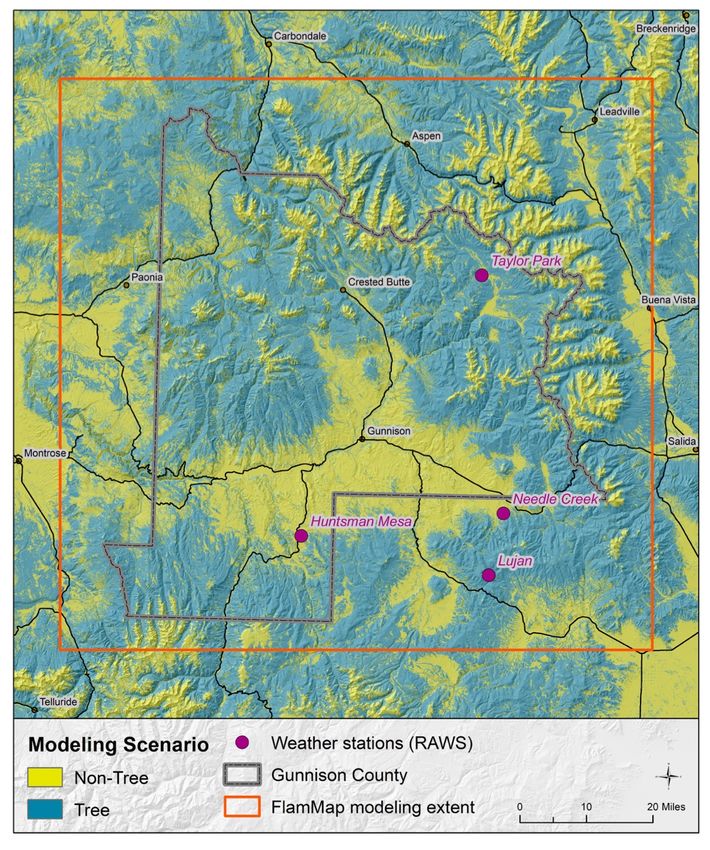
3. Susceptibility of values (for land use planning purposes, values consist of communities,
 structures, and infrastructure).
Together, these components complete the wildfire risk triangle (Figure 9).

Figure 9. Components of the wildfire risk triangle

Land use planning largely focuses on mitigating the susceptibility portion of the wildfire risk
triangle. There are two important susceptibility inputs that should be evaluated to appropriately
determine wildfire risk in the context of land use planning:

 • The location and density of structures and infrastructure;
 • The ignition potential of individual structures and infrastructure.
Implementing this recommendation will provide clear definition of Gunnison County’s wildland-
urban interface and integrate a hazard assessment map as a component of the decision support
tool for land use policies and regulations. The further incorporation of a property-specific
assessment system to complement the hazard assessment with a built environment
susceptibility component will provide a comprehensive risk assessment.

As part of the CPAW program, the USFS Rocky Mountain Research Station (RMRS) provides
wildfire risk and hazard assessment support. After assessing the current need, the CPAW team
engaged the RMRS to undertake an updated and refined countywide hazard assessment
(likelihood and susceptibility) to support this project. As a component of the hazard assessment,
the RMRS is also undertaking the SILVIS lab’s approach to spatially defining the WUI in
Gunnison County.

Community Planning Assistance for Wildfire / Gunnison County / 2019 14
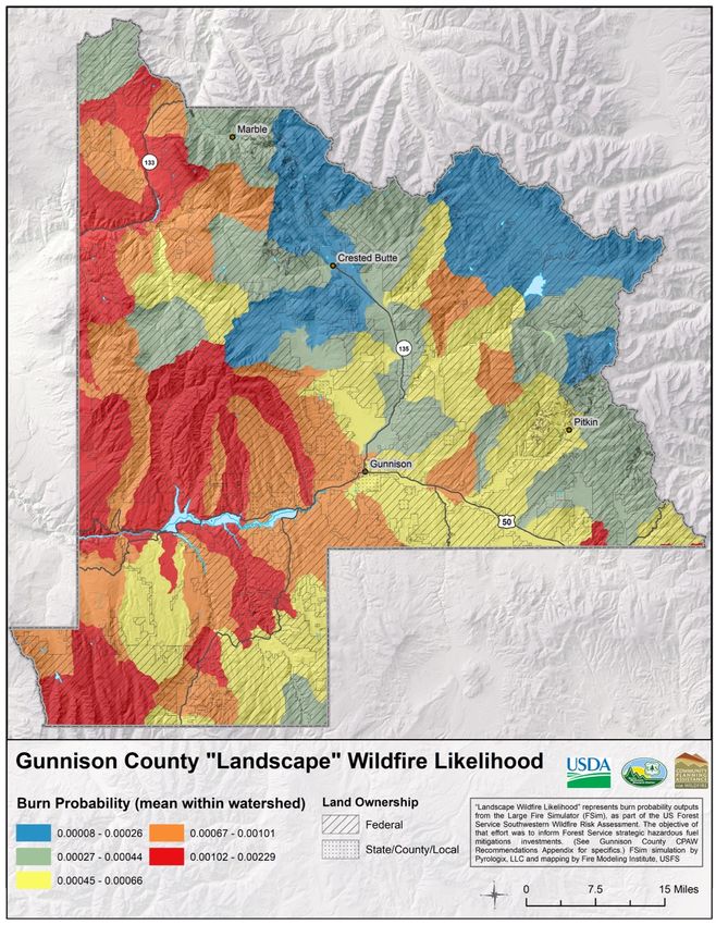
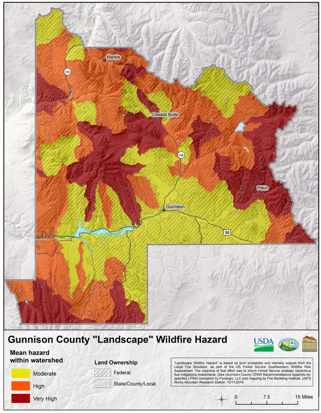
Individual Parcel-Level Assessments complete the risk triangle by providing the susceptibility
component. This focuses on assessing each structure and the immediate surroundings, or
Structure Ignition Zone (SIZ). The CSFS and the WRWC currently provide voluntary parcel-level
wildfire hazard assessments for landowners who request them. These parcel-level assessments
do not feed into any of the county-level hazard assessments.

As part of the CPAW process, RMRS staff engaged with local wildfire risk SMEs to achieve
three main objectives:
 1. Validate the RMRS spatial fuels layers.
 2. Explore RMRS tools that can be used to develop a single countywide hazard mapping
 product to better support land use planning and other wildfire risk reduction efforts.
 3. Spatially define the WUI.
This collaborative engagement was undertaken in the form of workshops in which local SMEs
worked with RMRS staff and CPAW team members to determine the appropriate parameters
and tools that would be useful in supporting local risk-reduction efforts.
As a result of this collaborative work, RMRS has calibrated the spatial fuel layer and developed
a methodology to provide spatial hazard assessment to support the implementation of land use
planning policy and regulations.

To provide an effective decision-support tool for the county and its partners, RMRS developed
the following wildfire hazard mapping outputs. Three maps are provided at two scales: the
Landscape-Level Wildfire Hazard (120-m pixel resolution), Local Wildfire Hazard (90-m pixel
resolution) which includes ember zones, and Mitigation Potential (30-m pixel resolution). A
summary of the methodology used to develop these outputs can be found in Appendix A.

This scale (120-m pixel resolution) represents the likelihood (probability) of a fire occurring and
the intensity of the fire at the landscape level based on the inherent landscape characteristics,
including broad existing vegetation, biophysical settings, fire regimes, and fire histories. To
provide the assessment in a format that is easily interpreted by the expected users (public,
developers, land use planners), the pixelated display was summarized to polygon boundaries
based on the U.S. Geological Survey Hydrological Unit Code (HUC) 12 (sub-watershed)
boundaries. The landscape-level hazard assessment (Figure 10) is delineated into the following
rankings:

 • MODERATE
 • HIGH
 • VERY HIGH
The factors influencing these rankings can be used to determine the potential landscape-level
exposure that a development will be subject to. The ranking at this scale is difficult to change at
the local/parcel level. Mitigation affecting change at this scale is typically done by large-scale
disturbances such as insect mortality, fires, or landscape-level mitigation.

Community Planning Assistance for Wildfire / Gunnison County / 2019 15
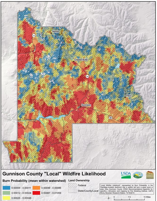
Figure 10. Gunnison County Landscape Wildfire Hazard Map

Land Use Planning Application: This application informs land use planners on the general
areas where fires are most likely to occur and where collaborative, multi-agency, large-scale fire
management planning and mitigation are necessary.

This scale (90-m pixel resolution) is based on an extreme event (worst fire days). To provide the
assessment in a format that is easily interpreted by the expected users (public, developers, land
use planners), the pixelated display was summarized to polygon boundaries based on the
catchment boundaries within the HUC 12 boundaries (Figure 11). This does not show the
likelihood of a fire occurring but does show where fires are likely to burn at high intensity. For
example, a fire that starts in an area where the local hazard is high can spread fast and burn at
high intensity creating significant wildfire exposure to any structures in the area. The same
rankings used at the landscape scale are used at this local scale:

Community Planning Assistance for Wildfire / Gunnison County / 2019 16
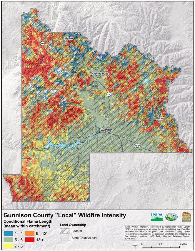
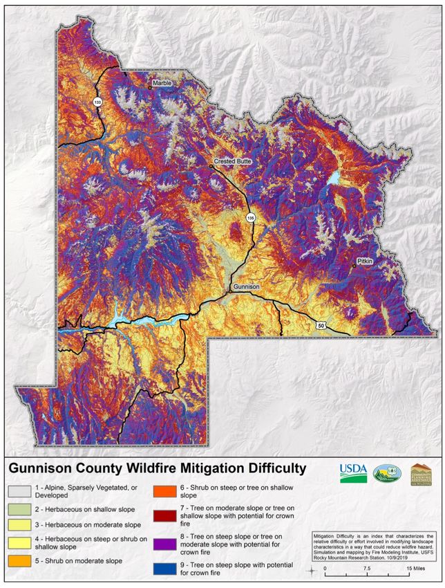
• MODERATE
 • HIGH
 • VERY HIGH

 Figure 11. Gunnison County Local Wildfire Hazard Map

Land Use Planning Application: This application informs land use planners on the relative
worst-case (hottest, driest, windiest days during a fire season) wildfire exposure (radiant,
convective, and ember) that can be expected in any given polygon where development exists or
is planned.

The Mitigation Difficulty component (30-m pixel resolution) uses the life form (grass, shrubs,
trees), slope, and crown fire potential to classify the potential mitigation success of any given
30-m pixel on the map (Figure 12). This is represented by nine categories (Table 4).

Community Planning Assistance for Wildfire / Gunnison County / 2019 17
TABLE 4. MITIGATION DIFFICULTY CLASSES AND DESCRIPTIONS

Class Characteristics Mitigation Discussion

 1 Sparsely Barren ground/water/developed/ sparse vegetation or land that lies
 vegetated, or within potential spotting distance of a wildfire. Mitigation will involve
 developed, with appropriate structure ignition zone and structure construction.
 potential for
 ember impact

 2 Herbaceous on Fires are typically easier to suppress in these areas. However, high
 a shallow slope winds combined with dry conditions lead to potentially dangerous, fast-
 (
TABLE 4. MITIGATION DIFFICULTY CLASSES AND DESCRIPTIONS

Class Characteristics Mitigation Discussion

 6 Shrubs on Significant challenges in fuel break construction; unlikely option for
 steep (≥30%) extensive mechanical (mastication) treatment. Significant potential for
 slopes erosion or slope instability resulting from treatments is a likely
 mitigation challenge. Increased rate of spread and significant intensity
 may make prescribed burning more difficult. Focus should be on a
 combination of appropriate mechanical treatment and burning, slope
 setbacks, structure ignition zone, and structure construction mitigation.

 Tree on shallow Open canopy must be maintained to prevent increased crown fire
 slope (
TABLE 4. MITIGATION DIFFICULTY CLASSES AND DESCRIPTIONS

Class Characteristics Mitigation Discussion

 9 Tree on steep Dense canopy needs to be thinned to reduce crown fire potential,
 slope (≥30%) which may be extremely difficult if not prohibitive due to the slope.
 with potential Surface fuels must be treated to reduce risk of fast-moving surface
 for crown fire fires. A very high potential for erosion or slope instability resulting from
 treatments is a likely mitigation challenge. Mitigation should also
 include appropriate slope setbacks, structure ignition zone, and
 structure construction mitigation.

Land Use Planning Application: This informs land use planners on the general potential
success and challenges of mitigation when aligning with the mitigation requirements of the
Wildland-Urban Interface regulatory requirements.

Community Planning Assistance for Wildfire / Gunnison County / 2019 20
Figure 12. Gunnison County Mitigation Difficulty Map

Parcel-level wildfire assessment requires a “boots on the ground” approach. Currently, the
Colorado State Forest Service and the West Region Wildfire Council are conducting voluntary
parcel-level assessments. It would be beneficial to the county if a standardized and
comprehensive approach were adopted by all partners across the county. In developing or
adopting this tool, consideration should be given to:

 • Incorporating the assessment of structure component susceptibility into the overall risk
 assessment.
 • Reflecting the most current best practices.
 • Collecting data in a format that can be easily tracked and integrated with and
 informative to mitigation difficulty and local hazard assessment maps, and that can
 provide meaningful risk reduction direction to property owners and land managers.

Community Planning Assistance for Wildfire / Gunnison County / 2019 21
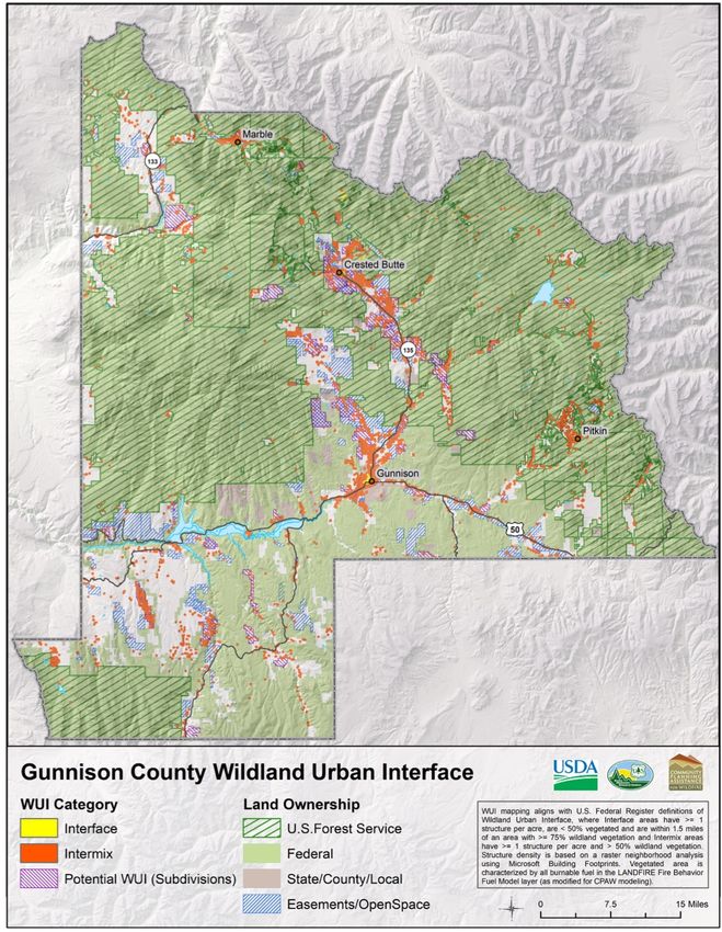
A general WUI definition used across all policies, plans, and regulations should account for the
“set of conditions” where vegetation (wildland fuels) and structures or infrastructure (built fuels)
are influenced by weather and topography to allow fire to ignite and spread through the WUI
environment. To provide the basis for a true understanding of the risk that Gunnison County
faces, the WUI should be more accurately defined as:

Any developed area where conditions affecting the combustibility of both wildland and built fuels
allow for the ignition and spread of fire through the combined fuel complex.
In order to provide a spatial reference in defining the WUI, the CPAW/ RMRS team modified
SILVIS lab’s approach for spatially defining the WUI. The SILVIS lab approach originated in the
Federal Register report 16 on WUI communities at risk from fire. This approach was modified by
the CPAW/RMRS team to the following parameters:

 • WUI Intermix: Areas with ≥1 house per acre and ≥50 percent cover of wildland
 vegetation. These areas have a potential for exposure to radiant and convective
 heat, as well as airborne embers.
 • WUI Interface: Areas with ≥1 house per acre and ≤50 percent cover of
 vegetation and within 1.5 mi of area with >= 75% wildland vegetation.
 • Non- WUI Vegetated (no housing): Areas with ≥50 percent cover of wildland
 vegetation and no houses (e.g., protected areas, steep slopes, mountain tops).
Based on these definitions, most of the developed areas (areas currently with habitable
structures, or platted subdivisions without structures (potential WUI) within Gunnison County
have been classed as WUI Intermix with some small areas of WUI Interface, mostly within the
City of Gunnison and Town of Crested Butte (Figure 13). All areas outside of federal land
ownership—including areas currently defined as “state, county, or local land ownership (grey
areas on map)”—also have the potential to become WUI if development is planned. Although
these areas of land ownership are not currently developed, the county should consider including
these areas as the spatially defined WUI.

16 USDA and USDI. 2001. Urban wildland interface communities within vicinity of Federal lands that are at high risk

from wildfire. Federal Register 66:751–777.

Community Planning Assistance for Wildfire / Gunnison County / 2019 22
Figure 13. Gunnison County Map of the Wildland Urban Interface and Wildland Urban Intermix

The landscape- and local-scale maps, as well as the mitigation potential wildfire exposure
maps, will be supplied as a geodatabase to the county. This will allow the user to explore a
hierarchy of hazard/exposure metrics including all of the elements described above. For
example, when a user clicks on a watershed polygon or mitigation pixel, the user will see the
elements that contribute to the calculation of the final hazard rating. The display of pixel-level
model outputs at finer display scales will also allow end-users to examine the spatial variability
of factors contributing to hazard and exposure with any watershed. The local-scale map and
mitigation-potential map will provide the opportunity for planners to appropriately assess a future
or existing development area for wildfire exposure and require the appropriate mitigation. It will
also provide a ranked scale to guide implementation of a wildland-urban interface code with
regards to the degree of standards that must apply based on exposure and mitigation and
whether the area is within the ember zone.

Community Planning Assistance for Wildfire / Gunnison County / 2019 23
The resulting hazard-assessment tool will be provided in the form of a geodatabase for addition
to the county’s geomatics servers as an ESRI ARC GIS layer. For the data to be made available
to land use planners and the development community, the expertise of a GIS specialist will be
required to ensure it is in the appropriate format for access and consumption by these groups.
The hazard assessment tools must be kept up to date to be relevant. A minimum default five-
year update schedule is recommended, unless updates are required to occur sooner, based on
the following:

 • Significant wildland fire activity;
 • Significant fuel management activity;
 • Significant forest health impacts, or other disturbances that alter large-scale vegetation
 structure;
 • Significant urban growth.
A best practices document (Appendix A) provides guidance to the town and county on the
methodology for updating the assessment. The hazard-assessment outputs should be strongly
linked as a decision support tool for implementing the proposed WUI requirements and planning
policies.

Community Planning Assistance for Wildfire / Gunnison County / 2019 24
Adopt the International Code Council International Wildland-Urban Interface Code (IWUIC) with
local amendments to establish minimum wildfire safety standards for future development in
Gunnison County.

Currently, Gunnison County broadly regulates wildfire through the Land Use Resolution (LUR).
All new construction, substantial improvement, use, fill, encroachments, alteration, fuel
modification or treatment are required to be designed in a manner that does not increase
potential intensity or duration of a wildfire. However, no specific construction standards are in
place, except for the regulation requiring mobile homes to have a weatherproof, fire-resistant
skirting. Class A roof materials are also required as a standard to be addressed in a recorded,
permanent protective covenant.
In addition to construction standards, the LUR prohibits development on any slope in excess of
30 percent that is also located in an area determined to be a severe wildfire hazard area, as well
as in a “fire chimney”, as identified by CSFS. Additionally, wildfire mitigation plans, including the
creation of defensible space, are required for parcels located in wildfire hazard areas; however,
the county does not request them as part of the review process. Finally, fuel modifications and
fuel breaks are required as a standard to be addressed in a recorded, permanent protective
covenant.
The current wildfire references and requirements in the LUR are a good start, but current
research and best practices indicate that additional required standards would significantly
reduce the potential wildfire losses to the county’s built environment and negative impacts on
life safety.
When adopted in full, the IWUIC provides jurisdictions with a minimum set of special regulations
for the “safeguarding of life and property from the intrusion of fire from wildland fire exposures
and fire exposures from adjacent structures and to prevent structure fires from spreading to
wildland fuels, even in the absence of fire department intervention.” In other words, the IWUIC
serves as a tool to strengthen the likelihood of a structure’s survival and reduce reliance on
suppression and response resources.

Many communities adopt the IWUIC with local amendments to better reflect their needs, such
as creating a local definition of the wildland-urban interface and referencing a locally appropriate
wildfire risk or hazard assessment.
CPAW recommends that the county adopt the IWUIC, with the following modifications:

Community Planning Assistance for Wildfire / Gunnison County / 2019 25
Replace IWUIC Fire Hazard Severity Rating with CPAW Hazard Assessment Tools
 Within the IWUIC, the Fire Hazard Severity methodology is used to determine appropriate
 mitigation requirements. The critical fire weather threshold within this rating does define all of
 Gunnison County as “Extreme”; however, within the local environment, it does not account for
 the differences between heat transfer (radiant, convective, conductive) exposure of individual
 structures.
 Heat transfer exposure and general mitigation guidance can be better demonstrated using the
 CPAW-generated “Local Wildfire Hazard” and “Mitigation Difficulty” maps to support land use
 planning and regulation within the county. The use of the wildfire hazard assessment for guiding
 the application of the IWUIC (2018) will link required mitigation actions to expected wildfire
 exposure (see Recommendation 1). The county should consider integrating the newly
 developed wildfire hazard assessment to determine the appropriate application of the proposed
 adopted IWUIC (2018) through the following process:
 A. Determine the Local Level Wildfire Hazard summarized ranking in which the proposed
 development is located to understand the likelihood of the building exposure to high-
 intensity fire.
 B. Determine the Mitigation ranking (0 to 9) of the parcel in which the proposed
 development is located and the parcel(s) immediately adjacent to it.
 C. Use the following table (Table 5) to determine the appropriate IWUIC mitigation
 standards to apply.

TABLE 5: GUNNISON COUNTY CPAW MITIGATION POTENTIAL/ IWUIC HAZARD CROSSWALK

Local Table 603.2 Minimum CPAW Mitigation Difficulty 24.301.181(21) Minimum IR
Wildfire Required Defensible Space and Slope % category Construction
Hazard (site/slope adjustment
 required)1
The CPAW team recommends adopting the IWUIC with local amendments as a standalone
code within the Title 14 Technical Codes. This ensures that the regulatory language is based on
a tested, current, coordinated set of regulations and best practices. Since the IWUIC not only
addresses construction standards but also addresses defensible space, fire water supply, and
access, adding it to Title 14 as a Technical Code provides for the most efficient process for
addressing updates in both the building code and the LUR when future IWUIC versions are
released.

The U.S. Fish and Wildlife Service seeks to prevent wildfires in sage-grouse habitat. This
objective ideally aligns with other community-based wildfire mitigation efforts in Gunnison
County. However, the CPAW team identified potential compatibility issues between maintaining
critical habitat and adequately planning for wildfire:
 1) providing defensible space for structures through construction and design, vegetation
 management and non-combustible zone requirements, while maintaining natural lek
 landscape, and;
 2) enabling sufficient access to lots and neighborhoods without constructing new roads in
 prime habitat.
Structure Ignition Zone (SIZ)
Structure Ignition Zone (SIZ) mitigation involves using appropriate construction design and
materials, as well as designing defensible space surrounding the building. Defensible space
mitigation focuses on intensive surface fuel management within the first 30 feet of a structure,
and less intensive vegetation management from 30 feet out to 100 feet (slope adjusted).
Mitigation in the first 30 feet typically includes the removal of conifer trees, cutting and
maintenance of grass, the use and arrangement of appropriate plants, and the mitigation of
accessory structures (sheds, decks, fences, etc.) using appropriate construction design and
materials. Mitigation between 30 feet and 100 feet (slope adjusted) typically includes the
thinning and pruning of conifer trees and the removal of surface and suspended dead and down
debris. However, the vegetation characteristics of sage-grouse habitat will typically only require
mitigation of the 30-foot defensible space zone. In many cases, where mitigation is required
beyond 30 feet, defensible space tree-thinning for wildfire mitigation may also be beneficial in
addressing encroachment of sage-grouse habitat.
The IWUIC allows for an alternative: a performance-based approach. In areas where conflict
may exist, the combination of addressing mitigation through construction design and materials
along with defensible space will often offer the opportunity to integrate sage-grouse habitat
protection objectives using a performance-based regulatory approach.
Access and Egress
The areas where the county has most concern for access and egress are typically in
subdivisions located in dense conifer forests, which likely do not conflict with sage-grouse
habitat. As with the SIZ, the desirable vegetation characteristics of sage-grouse habitat will likely
align with access and egress mitigation requirements. In cases where they do not align, the use
of a performance-based approach can offer opportunity to achieve both objectives.

Community Planning Assistance for Wildfire / Gunnison County / 2019 27
The Gunnison County LUR references wildfire mitigation requirements in several locations.
Based on acceptance of CPAW recommendations to adopt the IWUIC and the newly developed
wildfire hazard assessment mapping and develop a wildfire risk assessment program, the
CPAW team further recommends updating the LUR to reflect these changes (Table 6).

 TABLE 6. RECOMMENDED LUR CHANGES
 Section Issue Proposed Action
 §1-112: Use of • Maps are dated with and use • Amend section to refer to the new
 Maps multiple methodologies that may wildfire hazard assessment maps
 confuse the user. provided by CPAW.
 • Maps do not necessarily offer
 guidance at the most appropriate
 scale, or resolution to support land
 use planning and regulation.

 §2-102: • Wildland-Urban Interface is not • Wildfire Hazard Area – see terms
 Definitions defined in the current document.
 • Wildfire-Related Terms – review for
 consistency and add the Wildland-
 Urban Interface definition as proposed
 by CPAW.

 §3-106: Phase • Wildfire mitigation is not • Ensure major impact projects subject
 of Projects specifically addressed as a to wildfire mitigation requirements are
 compliance requirement. phased-in in a manner that reduces
 wildfire hazard to adjacent uses.

 §11-105.B. • Refers to wildfire hazard maps and • Amend section to refer to the new
 Development in in areas determined by the wildfire hazard assessment maps
 Areas Subject to Colorado State Forest Service. provided by CPAW.
 Wildfire Hazards
 - Applicability

 §11-105.B. • Refers to wildfire hazard maps • Amend section to refer to the new
 Development in developed by the Colorado State wildfire hazard assessment maps
 Areas Subject to Forest Service. provided by CPAW.
 Wildfire Hazards
 – Maps
 Incorporated

 §12-105: Water • Refers only to NFPA 1142 • Updated fire suppression water
 Supply Occupancy Hazard Classification supply requirements to refer to the
 Tables. IWUIC (2018) Section 404 for
 regulatory requirements and the entire
 • Addresses hazardous vegetation NFPA 1142 for specific technical
 as an acceptable indicator for guidance.
 increased conditions.
 • Amend section to refer to the new
 wildfire hazard assessment map
 provided by CPAW, the IWUIC IR

Community Planning Assistance for Wildfire / Gunnison County / 2019 28
You can also read