COMMUNITY INVOLVEMENT PLAN 2020 - CHEM CENTRAL SUPERFUND SITE 958874 - Records ...
←
→
Page content transcription
If your browser does not render page correctly, please read the page content below

958874

   COMMUNITY
INVOLVEMENT PLAN
      2020

  CHEM CENTRAL
 SUPERFUND SITE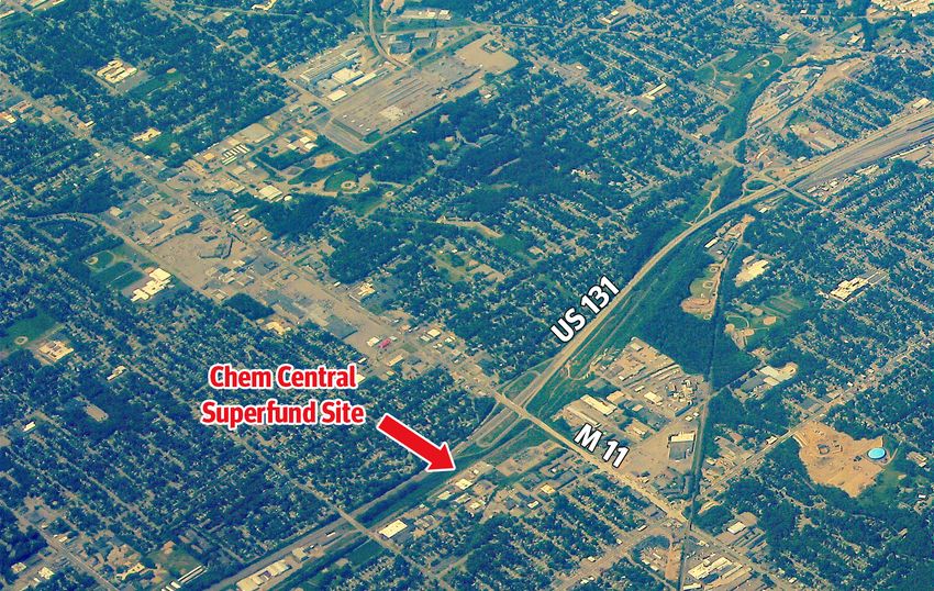
TABLE OF CONTENTS

    INTRODUCTION                                                                    1
     Describes the purpose of this CIP and presents EPA’s community
     engagement goals.

    THE SITE                                                                       3
     This section presents a description and history of activities at the site.

    COMMUNITY INVOLVEMENT
    GOALS AND ACTIVITIES                                                           9
     Highlights EPA’s Goals, activities and timeline to keep residents and local
     officials informed and involved.

    THE COMMUNITIES                                                                19
     Summarizes plans to engage community members regarding their
     concerns and provides a summary of the composition and history of
     the communities affected by the site.

        COMMUNITY CONCERNS AND QUESTIONS                                            20
          Plans for identifying community concerns and questions
          from the community.

        COMMUNITY PROFILE                                                           20
          Provides a summary of the composition and history of the
          city of Wyoming and Kent County.

i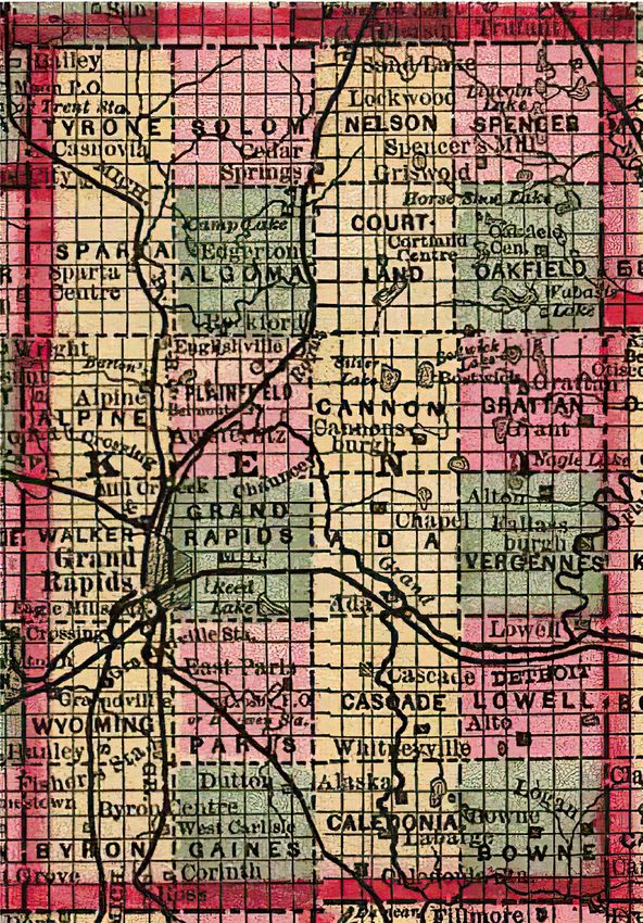
APPENDICES                                                         25
APPENDIX A · GLOSSARY/INITIALS/ACRONYMS                             25
  Definition of key words, initials, and acronyms (words are in
  bold throughout the document).

APPENDIX B · POTENTIAL COMMUNITY INTERVIEW QUESTIONS                31
  Proposed questions for future community interviews.

APPENDIX C · COMMUNITY RESOURCES                                    33
  Places where community members can find more information
  about the site and possible meeting locations.

APPENDIX D · LIST OF CONTACTS                                       35
  List of federal, state, and local agencies and interest groups
  (current as of June 2020).

APPENDIX E · COMMUNITY ENGAGEMENT & THE SUPERFUND PROCESS           41
  EPA’s step-by-step process to determine the best way to
  cleanup a contaminated site and opportunities for community
  involvement.

APPENDIX F · FACT SHEETS                                            43
  Includes site-related fact sheets, and ATSDR ToxFAQ.

APPENDIX G · ENVIRONMENTAL JUSTICE                                  63
  Explains EPA’s commitment to affected communities.

                                                                         ii
INTRODUCTION

                       Describes the purpose of this CIP
                       and presents EPA’s community
                       engagement goals.

    A CIP is a working document that will evolve as
    the investigation and cleanup process continues
    and input is received from the community. It is
    intended to be flexible, adaptable and used as
    a guideline for our communication with the
    community.

                                The Chem Central Superfund Site is currently
                                on the National Priorities List, and community
                                involvement for the site is covered under the
                                Superfund program. See Appendix E for more
                                information on Superfund.

1
The U.S. Environmental Protection Agency prepared this Community
Involvement Plan to inform, engage and support the community affected            Words in bold
by the Chem Central Superfund Site, located in Wyoming, Kent County,
Michigan. Our community involvement effort is committed to promoting             are defined in
effective and meaningful communication between the public and the                Appendix A.
Agency. We want to make sure the community’s current concerns and
information needs are considered as activities at the site progress.

This CIP was prepared to support environmental and investigation activities at the
Chem Central Superfund Site. As we continue to adjust to the evolving COVID-19
situation, EPA is taking the necessary steps to ensure that decisions about ongoing
activities at Superfund sites are made with the health and safety of communities, EPA
staff, state and tribal partners, and contractors as the priority. Due to the Michigan
Governor’s stay-at-home order, EPA was unable to conduct community interviews
while preparing this document. Future iterations of this community involvement plan
will include input from local community members.

EPA’S COMMUNITY ENGAGEMENT GOALS
  1. Broaden community awareness of the site.

  2. Help community members understand their role in the decision-making process
     throughout the cleanup process.

  3. Give the public accessible, accurate, timely and understandable information
     about the project as it moves forward.

  4. Reflect and respond to community concerns, questions and information needs.

  5. Ensure adequate time and opportunity for the public to give informed and
     meaningful input and for that input to be considered throughout the cleanup
     process.

This CIP describes EPA’s plan for addressing concerns and keeping residents informed
and involved in investigation and oversight activities at the site. We will use this
document as a guide to involve and communicate with residents, businesses and the
local governments in the city of Wyoming and Kent County.

If you are interested in submitting comments or have questions or suggestions
concerning this CIP, please contact:

Diane Russell
Community Involvement Coordinator (CIC)
EPA Region 5 Community Information Office
1300 Bluff St., Suite 140
Flint, MI 48504
989-395-3493
russell.diane@epa.gov

                                                                                                  2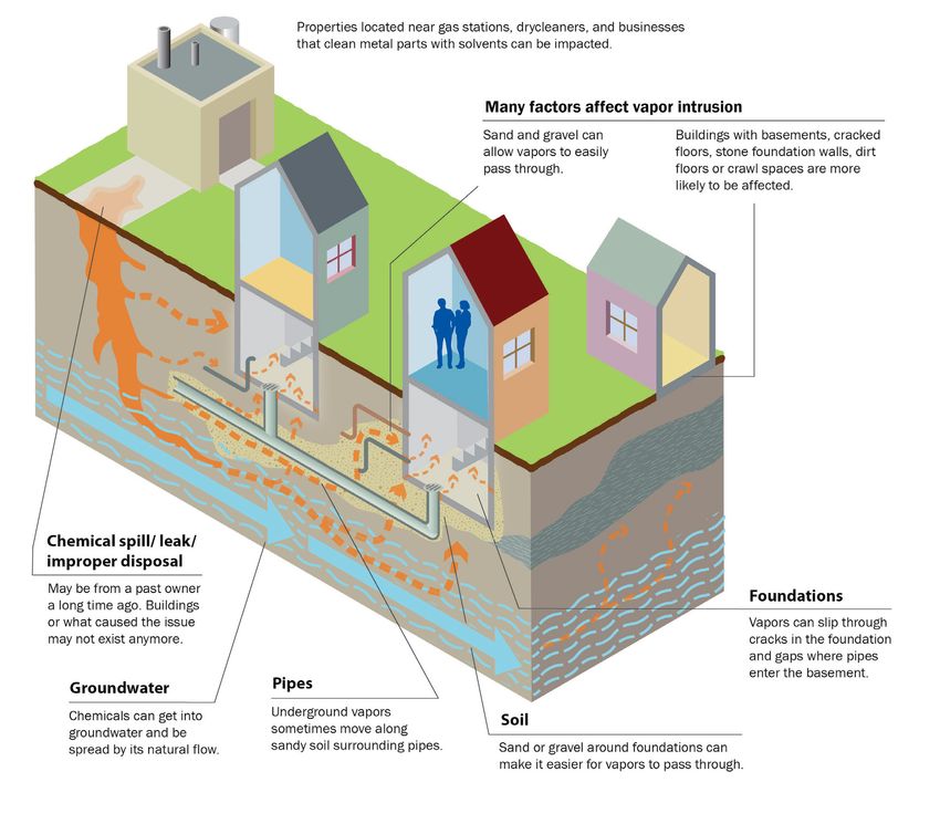
THE SITE

        This section presents a description
        and history of activities at the site.

                                            Site Location

3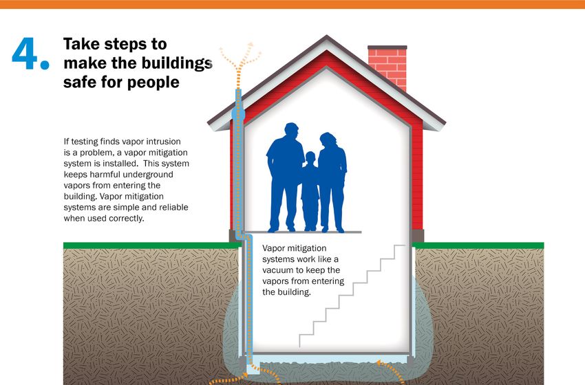
SITE LOCATION
The Chem Central Superfund site is situated in a mixed residential and commercial
section the city of Wyoming, Michigan. It consists of a two-acre parcel of land owned
by Univar USA Inc. (formerly ChemCentral Corporation); a rectangular piece of land
owned by Consumers Power extending north of the Univar USA Inc. property; Cole
Drain, a northerly flowing creek along the site’s western boundary; and any property
beyond the Univar USA Inc. property where hazardous substances from the site
are located. Contamination has been identified in soil and groundwater at nine
properties, including the Univar USA Inc. property. The adjacent properties north and
south of the site are privately owned and occupied by commercial and light industrial
facilities. The nearest residences are located 500 feet to the east of the property
boundary, and two hotels with residential use are located within 800 feet of the site.

                                                                              Aerial View, 2009

WATER SUPPLY
The City of Wyoming has been using Lake Michigan as a source of drinking water since
1966. The City’s water supply system currently services a population of approximately
230,000 people in Wyoming and various wholesale customers.

No residents are currently using the groundwater down-gradient of the Site. One
commercial well is located at the C.D. Osborn facility, which is side-gradient to the Site.

“Aerial View, 2009” by brewbooks (CC BY-SA 2.0)
   commons.wikimedia.org/wiki/File:Wyoming,_Michigan_aerial_2009.jpg                              4
   creativecommons.org/licenses/by-sa/2.0/
Institutional controls in the form of deed restrictions, which prohibit the installation
    of water wells in the site area and any future development that might disturb
    contaminated soils, have been, or will be filed for the site and some surrounding
    impacted properties.

    SITE HISTORY
    The site has continuously operated as an industrial chemical distribution facility
    since it was constructed in 1957. The property was undeveloped prior to that time. The
    facility was first operated by ChemCentral Corporation, which was later succeeded
    by Univar USA, Inc.

    Hazardous substances entered the ground at the site through a construction error in a
    T-arm pipe used to transfer liquid products from bulk storage tanks to small delivery
    trucks, sometime between 1957 and 1962. After losses in chemical inventories were
    noticed, the construction flaw was discovered and then repaired. It is possible that
    accidental spills also caused hazardous substances to enter the ground.

    The site was discovered in 1977 during a routine biological survey of Plaster Creek,
    when oils and concentrations of polychlorinated biphenyls (PCBs) and metals
    were detected in a ditch draining into Cole Drain, located immediately north of 28th
    Street and the Univar USA, Inc. property.

    Between 1978 and 1986, EGLE and EPA focused their efforts on finding and eliminating
    the source of the ditch contamination through extensive investigations of the area
    soil, groundwater, and surface water. Results indicated that groundwater and soil
    surrounding and north of the ChemCentral Corporation facility were contaminated
    with volatile and semi-volatile organic compounds.

    In December 1982, the property was proposed for inclusion on the National Priorities
    List (NPL) and finalized on the list in 1983.

    In 1984, the court ordered the ChemCentral Corporation undertake clean-up activities
    that included: (1) defining the extent of contamination; (2) designing, constructing,
    and operating a groundwater collection and treatment system until court-ordered
    clean-up standards were met; and (3) cleaning up contaminated soils in the ditch.
    Consequently, between 1984 and 1985, three groundwater extraction wells, an
    interceptor trench, and a treatment system using an air stripper were installed. The
    ditch was also dewatered, contaminated materials were removed, and was backfilled
    with clean material. An underdrain was installed in 1986 to prevent contaminated
    groundwater from entering Cole Drain.

    In June 1987, pursuant to an administrative order by consent with EPA, ChemCentral
    Corporation conducted a Remedial Investigation from August 1988 through January
    1989, and Feasibility Study from 1989 through 1991, pursuant to an administrative
    order by consent with EPA.

    The Remedial Investigation identified approximately 35 different organic compounds
    in the groundwater. Low concentrations of chlorinated compounds were detected

5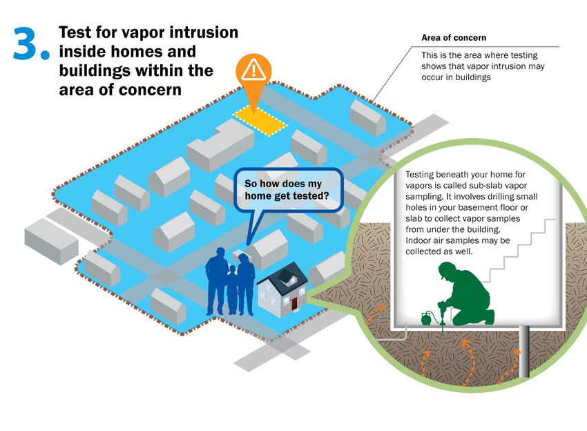
up-gradient from the property, originating from an unknown source. Groundwater
contamination was detected in a plume extending north of the property down-gradient
to the Cole Drain near Mart Street. Contaminated groundwater was not flowing into
Cole Drain based on the results of surface water samples collected from the drainage.

The Feasibility Study was completed on June 21, 1991. EPA issued the Record
of Decision on September 30, 1991, which selected a remedy for contamination
onsite soil, contaminated offsite soil surrounding and north of the plant, and the
contaminated plume emanating northward from the facility. Contaminates of
concern effecting the soil and groundwater are: volatile organic compounds (VOCs)
including tetrachloroethylene (PCE), trichloroethylene (TCE), and toluene; and
other organics including polycyclic aromatic hydrocarbons (PAHs) and PCBs.

The site achieved remedy construction completion with the signing of the Preliminary
Closeout Report on September 19, 1995. The remedy includes:

  • Continued operation of the existing groundwater collection and treatment
    system;

  • Installation, operation and maintenance of an expansion of the current off-
    property groundwater collection system, either by extending the interceptor
    trench or installing additional extraction wells;

  • Installation, operation and maintenance of an extraction well at the deep
    location of contaminated groundwater identified in the Remedial Investigation;

  • Collection of oil in the extraction wells and disposal of the oil at the off-site
    facility in accordance with applicable federal and state regulations;

  • Installation, operation and maintenance of a soil vapor extraction system for
    soils on property as well as two off-property locations just north of the Chem
    Central property;

  • Institutional controls, such as deed restrictions, to prohibit the installation
    of water wells in the site area and any future development that might disturb
    contaminated soils; and

  • Implementation of a groundwater monitoring program capable of demonstrating
    the effectiveness of the groundwater capture system.

Operations, maintenance and monitoring of these remedies continues today. EPA
expects further work will be needed at the site including an assessment of the extent
of contaminated groundwater and vapor intrusion.

                                                                                        6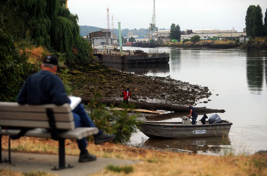
A vapor intrusion assessment is currently in progress at the site and certain
    surrounding properties. EPA continues to evaluate the impact of vapor intrusion
    in this area. For additional information regarding vapor intrusion, see the Vapor
    Intrusion Update for the Chem Central Superfund fact sheet in Appendix F.

                                                     Vapor Intrusion Diagram

    This is a depiction of the migration of vapors in soil gas from contaminated soil and
    groundwater into buildings. Vapors in soil gas are shown entering buildings through
    cracks in the foundation and openings for utility lines. Atmospheric conditions and
    building ventilation are shown to influence soil gas intrusion.

    For more detailed information regarding the site’s remedy, refer to the Fifth Five-Year
    Review Report for the site, available here: semspub.epa.gov/work/05/572919.pdf

7
This page intentionally left blank.
8COMMUNITY INVOLVEMENT
GOALS AND ACTIVITIES
Highlights EPA’s goals, activities
and timeline to keep residents
and local officials informed and
involved.
9When establishing the objectives for a site-specific community involvement program,
we consider several factors including federal requirements and EPA policy that
assess the nature and extent of known or perceived site contaminants and known
community concerns and requests.
To be effective, our community involvement program is designed to meet the
community’s need to know, give information in a timely manner and accommodate the
community’s interests and its willingness to participate in decision-making processes.
We must also share information in an understandable and usable format.
EPA designated Diane Russell as the community involvement coordinator, or CIC for
the site. The role of a CIC is to be a primary liaison between the community and EPA to
ensure prompt, accurate, and consistent responses and information are disseminated
about the site as well as to provide information to EPA about community needs. For
technical site issues, Diane coordinates with EPA’s remedial project manager, or
RPM, for the site, Matthew Ohl. Current contact information for the project staff will
be included on all written and electronic information and the community will be
notified of any contact information changes.
Diane Russell
Community Involvement Coordinator (CIC)
989-395-3493
russell.diane@epa.gov
Matthew Ohl
Remedial Project Manager (RPM)
312-886-4442
ohl.matthew@epa.gov
OUTREACH GOALS AND METHODS
EPA has or will put in place the activities described on the following pages to provide
meaningful and active engagement with the community in decisions regarding the
investigation and cleanup of the Chem Central Superfund Site. The following plan
provides opportunities for communication between the community and EPA to
address key concerns and questions anticipated from the community.
10Maintain point of contact COMPLETED
Share site information on the internet COMPLETED
UPDATE AS NEEDED
Establish and maintain a site-specific information COMPLETED
repository and administrative record UPDATE AS NEEDED
Develop a Community Involvement Plan COMPLETED
UPDATE AS NEEDED
Create and maintain the site mailing list ONGOING
UPDATE AS NEEDED
Prepare and distribute fact sheets and site updates PREPARE AS NEEDED
Write and distribute news releases and public notices PREPARE AS NEEDED
Hold public meetings and open house sessions CONDUCT AS NEEDED
Participate in meetings of local community groups AS IDENTIFIED
Solicit input during public comment periods AS REQUIRED
Prepare and issue a responsiveness summary AS REQUIRED
Provide information about technical resources AS IDENTIFIED
Evaluate community engagement and outreach PERIODICALLY THROUGHOUT
CLEANUP PROCESS
efforts and make adjustments as warranted. UPDATE AS NEEDED
POINTS OF CONTACT INFORMATION REPOSITORY
Diane Russell
Community Involvement
Coordinator (CIC)
989-395-3493 Toll Free Number:
russell.diane@epa.gov 312-621-8431
Matthew Ohl Website: Kent District Library Kent District Library
Remedial Project Manager epa.gov/superfund/chem-central Wyoming Branch Grandville Branch
312-886-4442 3350 Michael Ave. SW 4055 Maple St. SW
ohl.matthew@epa.gov Wyoming, MI 49509 Grandville, MI 49418
11SPECIFIC COMMUNITY INVOLVEMENT METHODS
To meet federal requirements and take action on EPA’s commitment to community
engagement, EPA has utilized or will utilize the methods described below. Through
these activities, it is our aim to inform, involve and engage the community during
site cleanup decisions and efforts. As the needs of the community change, we will
modify the community involvement strategies to address them.
MAINTAIN POINT OF CONTACT
The EPA CIC is the primary liaison between EPA and the community. The CIC fields
general questions about the site. For technical site issues, the CIC coordinates with
EPA’s remedial project managers, or RPMs. We will include current contact information
for the project staff on all written and electronic information and will notify the
community of any contact information changes. EPA has designated the following
people as primary site contacts for local residents:
Diane Russell Matthew Ohl
Community Involvement Coordinator (CIC) Remedial Project Manager
989-395-3493 312-886-4442
russell.diane@epa.gov ohl.matthew@epa.gov
PROVIDE SITE INFORMATION ON THE INTERNET
A site status summary can be found at: epa.gov/superfund/chem-central
Objective: To provide key resources for searching and listing both general and
specific information about the site.
Timing: The website is frequently updated.
Chem Central Superfund Website
12ESTABLISH AND MAINTAIN A SITE-SPECIFIC INFORMATION
REPOSITORY AND ADMINISTRATIVE RECORD
A local information repository, which includes the site’s Administrative Record,
has been established at:
Wyoming Branch Grandville Branch
Kent District Library Kent District Library
Wyoming Branch Grandville Branch
3350 Michael Ave. SW 4055 Maple St. SW
Wyoming, MI 49509 Grandville, MI 49418
kdl.org/locations/wyoming kdl.org/locations/grandville
The official information repository is located at:
EPA Region 5 Superfund Records Center
Room 711, 7th Floor
Ralph Metcalfe Federal Building
77 W. Jackson Blvd.
Chicago, IL 60604
The Administrative Record is also available online at the site’s web page:
epa.gov/superfund/chem-central
Objective: The information repository provides a convenient location where residents
can go to read and copy official documents and other pertinent information about
the site and EPA activities.
Timing: Documents are updated as new information becomes available.
DEVELOP A COMMUNITY INVOLVEMENT PLAN
A Community Relations Plan was developed by the state in 1988. This CIP replaces
that plan, and was developed based on research into the community. EPA plans to
conduct interviews with community members, when it is safe to do so, to identify areas
13of concerns pertaining to the site. EPA will revise the CIP based on newly identified
community concerns and site investigation information.
Objective: To identify and address community needs, issues or concerns, and to
articulate a plan to inform the community of EPA’s methods to provide information
and achieve meaningful involvement.
Timing: CIP completed Summer 2020.
CREATE AND MAINTAIN SITE-SPECIFIC MAILING LIST
A mailing list will be created to include all residences and businesses that have
expressed an interest in staying informed about the site. This is a way to ensure that
those who do not have access to the Internet or other information sources still receive
information about the site.
Objective: To facilitate the distribution of site-specific information to everyone who
needs or wants to be kept informed about the site.
Timing: Reviewed and revised periodically.
PREPARE AND DISTRIBUTE FACT SHEETS AND SITE UPDATES
EPA has produced fact sheets and
site updates written in non-technical
language and distributed to coincide Vapor Intrusion Update for the Chem
with site milestones (such as the Central Superfund Site
Chem Central Superfund Site
commencement of an expanded vapor Wyoming, Michigan February 2019
intrusion investigation). EPA will For more information
U.S. Environmental Protection Agency, working with the Michigan Department
of Environmental Quality, has completed vapor intrusion sampling at six
continue to produce fact sheets and site If you have questions or comments
on the Chem Central site, contact:
properties in the area around the Chem Central Superfund site. The sampling
results are available in a report on the website. The information will be used to
updates as site cleanup/investigation
determine the long-term effectiveness of the cleanup process for the site as part
For general questions: of a five-year review. No immediate health threat has been identified, but more
Diane Russell testing is needed.
efforts progress. EPA will identify Community Involvement
Coordinator
What is vapor intrusion?
next steps to provide a roadmap for
Vapors, also referred to as soil gases, evaporate from underground pollutants
989-395-3493 and get trapped between dirt particles. Vapor intrusion occurs when the soil
russell.diane@epa.gov gases move up through the ground and seep into buildings through holes or
the community to understand the For technical questions:
cracks in the foundation and cause hazardous indoor air pollution. If these gases
enter a home, occupants can inhale them, which can potentially affect their
expected activities for the year.
Matthew Ohl health. In buildings with lower concentrations of vapor-forming chemicals
Remedial Project Manager arising from vapor intrusion, the main concern is whether the chemicals may
312-886-4442 pose an unacceptable risk of health effects due to long-term or chronic exposure
ohl.matthew@epa.gov to these lower levels.
Objective: To provide community EPA address:
U.S. EPA Region 5
members with current, accurate, Superfund Division
77 W. Jackson Blvd.
easy-to-read and easy-to-understand
Chicago, IL 60604 Figure 1. This image depicts the
migration of vapors in soil gas
You may call the EPA toll-free at from contaminated soil and
information about the site. 800-621-8431, weekdays,
9:30 a.m. – 5:30 p.m.
groundwater into buildings.
Vapors in soil gas are shown to
enter buildings through cracks in
the foundation and openings for
Website: utility lines. Atmospheric
Timing: As needed. https://www.epa.gov/superfund/che conditions and building
ventilation are shown to influence
m-central
soil gas intrusion.
To view the sampling results:
https://semspub.epa.gov/src/docume
nt/05/943935
Vapor intrusion sampling
For more information on vapor As the cleanup is being completed at this site, EPA and property owner Univar
intrusion: USA Inc. have been retesting the area for vapor intrusion problems. This is due
https://www.epa.gov/vaporintrusion to advances in the understanding of how chemical vapors can affect the air in
buildings overlaying contaminated soil and groundwater (underground water
supplies).
Toeroek Associates, an EPA contractor, began work in March 2018. Toeroek
was tasked with collecting sub-slab soil vapor and indoor air samples from six
properties around the Chem Central site and previously identified groundwater
contaminant plumes. This is to determine current pollution concentrations and to
check if a complete pathway for vapor intrusion risk potentially exists for these
properties.
14family and I.”
ty Manager Mark Washing- as he continues to serve the Lansing Police
Department.” Lansing Police Chief Michael Yankowski
After pulling his name, Yankowski said he
wishes nothing but success to Grand Rapids
PIDS and its community as it continues to “grow Police Department since 1994. He was pro-
together as a community.” moted to interim captain in March 2010 and
Yankowski has been with the Lansing chief in 2013.
ES
y located at 1300 Market Ave SW.
OW AND A MINIMUM BID OF
ST REGISTERED OWNER
ING INC LSR JAMAAL DESHAWN
LE LSE EPA Begins Review
MARIE RAU
of Chem Central Superfund Site
MICHAEL THOMAS
Wyoming, Michigan
WRITE AND DISTRIBUTE NEWS
ERT CROSSLEY
ANTHONY LEBEAU
URICE PRECORD
U.S. Environmental Protection Agency (EPA) is conducting a five-year review of the Chem
Central Superfund site, located at 2940 Stafford Ave., Wyoming. The Superfund law requires
RELEASES AND PUBLIC NOTICES
ANCE-UNIQUE JOHNSON-HAYES
VILLAFUERTE regular checkups of sites that have been cleaned up – with waste managed on-site – to make sure
L ANDREW THOMAS JR that the cleanup continues to protect people and the environment. This is the fifth five-year
ANE PELLERITO JR review of this site.
COTT LOVAAS
MINQUE CHARLTON
EPA’s cleanup of spilled industrial chemicals included collection and off-site disposal of
OBERT VERVILLE
OSE-MARSHALL WHITEFIELD
chemicals, soil vapor extraction and groundwater pumping and treatment, and long-term
monitoring. EPA, working with the Michigan Department of Environment, Great Lakes, and EPA has released announcements to the Grand Rapids
ER INFORMATION
EE-JOSH PITTMAN
Energy (EGLE) has completed vapor intrusion sampling at six properties in the vicinity of the
Chem Central Superfund site and has placed sampling results on the site webpage. The current Press to notify the public of important site-related
N HAYDEN
LYNN WOODY
site owner, Univar USA Inc. is completing further vapor intrusion sampling to the north of the
site above the groundwater contamination plumes that extend away from the original location. information and events. Most recently, on June 30, 2019,
EPA released a public notice indicating that a Five Year
SE WILSON
MONIQUE EWING More information is available at the Kent District Library – Wyoming Branch, 3350 Michael
Ave. SW, Wyoming; or online at https://www.epa.gov/superfund/chem-central.The review
Review of the site was taking place, and inviting the
ELISSA SHARP
9227653-01
NG ZMARLY should be completed in August 2019.
public to submit any comments to EPA. No comments
E ERNSBERGER-LOENARD
YNEMA & HANNAH JAE ROOD The five-year-review is an opportunity for you to tell EPA about site conditions and any
A LATRIES JOHNSON-MOORE AND concerns you have. Contact:
NSON-MOORE
NIEL WEIDNER KENDRA LEIGH
Diane Russell Matthew Ohl were received by the public at that time.
OCHELLE JONES EPA Community Involvement Coordinator EPA Remedial Project Manager
AY GANT 989-395-3493 312-886-4442
HA MCPEAK
N
russell.diane@epa.gov ohl.matthew@epa.gov
Objective: To provide the latest news and information
9227139-01
You may call EPA toll-free at 800-621-8431, 9:30 a.m. to 5:30 p.m., weekdays.
to local media outlets to reach large audiences quickly.
Timing: EPA typically publishes news releases and public notices to announce major
events such as comment periods, public meetings, and major milestones such as
the selection of a cleanup remedy. This method will be used as needed.
HOLD PUBLIC MEETINGS AND OPEN HOUSE SESSIONS
EPA will use public meetings and open house sessions to exchange information or
meet with residents to discuss site activities. A public meeting typically consists
of a presentation followed by a question-and-answer session. An open house is
an informal meeting where people can talk to agencies on a one-on-one basis.
Scheduling meetings should remain flexible to account for technical milestones and
public interest. EPA will use public meetings as required by regulation where EPA
can hear the public’s views and concerns about an EPA action or proposal. EPA will
schedule, prepare for and attend all announced meetings. EPA will provide at least a
two-week notice of a scheduled meeting. The Remedial Project Manager, Community
Involvement Coordinator, and other appropriate EPA staff will attend.
Objective: To update the community on site developments and address questions,
concerns, ideas and comments.
Timing: EPA will hold public meetings or open house sessions as appropriate.
PARTICIPATE IN MEETINGS OF LOCAL COMMUNITY GROUPS
EPA may offer speakers to local organizations, business clubs and schools as another
means of communicating important information to local residents. These meetings
can be an effective, convenient way for EPA to interact with the community, convey
information, and solicit questions and input from targeted groups. By attending
previously scheduled community meetings, residents are able to participate without
having to disrupt or change their schedules.
15Objective: To update the community on site developments and address questions,
concerns, ideas and comments, and to provide the site team with a viable means of
learning citizens’ concerns and attitudes at locations and times that are convenient.
Timing: As identified.
SOLICIT INPUT DURING PUBLIC COMMENT PERIODS
EPA will announce each comment period separately. Announcements will appear
in local newspapers and EPA fact sheets and will include information regarding
the duration of the comment period, how to make comments, and where to submit
comments, etc. For this site, EPA last solicited public comments regarding the site
conditions and concerns in June 2019, leading up to the preparation of the fifth Five
Year Review for the site. No comments were submitted.
Objective: To give community members an opportunity to review and comment on
key decisions. This provides the community members with meaningful involvement
in the process. It also provides the site team with valuable information for use in
making decisions.
Timing: As required by regulations.
PREPARE AND ISSUE A RESPONSIVENESS SUMMARY
EPA prepares responsiveness summaries to comments, criticisms and new data
received primarily during Public Comment Periods, which typically occur when the
site is proposed to the National Priorities List (NPL), the remedial plan is proposed for
the Record of Decision (ROD), and the notice of intent to delete the site from the NPL
is issued. The comments include oral or written input submitted at public meetings or
during public comment periods, as well as major issues and concerns raised during
the various phases of the program.
Objective: To provide a brief summary of community concerns and document EPA’s
response to the comments. Responsiveness summaries are intended to be concise and
complete reports that the public can understand.
Timing: Responsiveness summaries are made available with the ROD or other
relevant decision documents.
16PROVIDE INFORMATION ABOUT TECHNICAL RESOURCES
Technical assistance refers to the provision of services focused on increasing community
understanding of the science, regulations and policy related to environmental issues
and EPA actions. To support healthy communities and strengthen environmental
protection, EPA works closely with communities to make sure they have the technical
help they need. Sometimes, a community may need more help to fully understand local
environmental issues and participate in decision-making. EPA provides additional
assistance to communities through a variety of technical assistance resources and
tools. These resources include:
Technical Assistance Needs Assessment (TANA) Process
epa.gov/superfund/technical-assistance-needs-assessments-tanas
This process identifies additional support that a community may require in order to
understand technical information and participate meaningfully in the Superfund
decision-making process. A TANA helps EPA determine what technical assistance
resources and information the Agency can provide to meet community needs.
Technical Assistance Services for Communities (TASC) Program
epa.gov/superfund/technical-assistance-services-communities-tasc-program
This program provides services through a national EPA contract. Under the contract, a
contractor provides scientists, engineers and other professionals to review and explain
information to communities. TASC services are determined on a project-specific basis
and provided at no cost to communities.
Technical Assistance Grant (TAG) Program
epa.gov/superfund/technical-assistance-grant-tag-program
TAGs are awarded to non-profit incorporated community groups. With TAG funding,
community groups can contract with independent technical advisors to interpret
and help the community understand technical information about their site. The
TAG recipient group is responsible for managing their grant funds and contributing
a 20 percent award match. Most groups meet this requirement through in-kind
contributions such as volunteer hours toward grant-related activities.
Technical Assistance Plan (TAP)
epa.gov/superfund/technical-assistance-plan-tap
A TAP is funded by potentially responsible parties through provisions in a negotiated
settlement agreement. A TAP enables community groups to retain the services of an
independent technical advisor and to provide resources for a community group to
help other community members learn about site decisions.
Objective: To provide resources and tools to assist the community to understand
local environmental issues and to maximize public participation in decision-making.
Timing: EPA will work with the community to find the most appropriate resources
when warranted.
17EVALUATE COMMUNITY ENGAGEMENT AND OUTREACH
EFFORTS AND MAKE ADJUSTMENTS AS WARRANTED
EPA will keep track of outreach and community engagement activities. EPA may
make revisions to its community outreach methods and approaches and implement
additional activities not mentioned in this CIP, based on feedback from residents
and local officials.
Objective: To assess the effectiveness of community engagement and outreach efforts
and make changes as necessary.
Timing: EPA will track activities and report as needed.
18THE COMMUNITIES
Summarizes plans to engage
community members regarding
their concerns and provides a
summary of the composition
and history of the communities
affected by the site.
Autumn in Kent County
19CONCERNS AND QUESTIONS
EPA received no comments from the public in its last solicitation of public comments
during the period leading up to the completion the fifth Five Year Review for the
site. As we continue to adjust to the evolving COVID-19 situation, EPA is taking the
necessary steps to ensure that decisions about ongoing activities at Superfund sites are
made with the health and safety of communities, EPA staff, state and tribal partners,
and contractors as the priority. Due to the Michigan Governor’s stay-at-home order,
was unable to conduct community interviews while preparing this document. Future
iterations will include a summary of community interviews.
A summary of community interviews will be included in future iterations of this CIP.
Appendix B includes a list of potential questions EPA will pose to community members.
COMMUNITY PROFILE
Provides a summary of the composition and history of the city of Wyoming and Kent
County.
CITY OF WYOMING
The city of Wyoming contains 24.85 square miles, and is located
immediately south of Grand Rapids, in southwest Kent County.
Downtown Wyoming is a 3.5-mile stretch of five-lane 28th Street,
one of Michigan’s busiest roadways. Commercial establishments are
concentrated in this area, along with City Hall and Rogers Plaza, Kent
County’s first shopping mall. Wyoming is Michigan’s 16th largest
community, and the 3rd largest community in West Michigan.
Wyoming was first settled by individuals of European decent in 1832, 28th Street
and was organized under Byron Township. The township split into 1848; the northern
half was named Wyoming Township, after Wyoming County, New York, the area from
which the majority of the original settlers came. It became a city in 1959. The city has
experienced continuous population growth with every census since 1890.
Currently the Metro Health Hospital and Gordon Food Service are
Wyoming’s two largest employers. Wyoming’s top three industries
include: manufacturing (30%); retail (16%); and education, health,
and social services (15%).
The city has 21 parks, covering approximately 665 acres of land. The
Kent Trail system also runs along abandoned rail lines in the area
that were converted into bike paths. The Wyoming Branch of the
Kent District Library was constructed in 2002 it. It has the highest
attendance in the Kent district system.
20
Wyoming City Water TowerGOVERNMENT STRUCTURE
The city of Wyoming is governed by a mayor and a six
member city council, consisting of representatives from
the 1st, 2nd, and 3rd Wards, and three members-at-large.
The site is located in the 9th Precinct in the 1st Ward. The
Wyoming City Hall mayor and council members are elected to four-year terms,
and are responsible for adopting city ordinances, approving
annual city budgets, and appointing the city manager, city clerk, comptroller, city
attorney, and members to boards and commissions. The city manager serves as the
city’s chief administrative officer, and addresses administrative services as directed
by the city council.
City council meetings are held at City Hall, located at 1155 28th Street SW, Wyoming,
Michigan, on the first and third Monday of every month. Contact information for
individual city officials is listed in Appendix D.
The websites below were used to gather the information provided in this section:
en.wikipedia.org/wiki/Wyoming,_Michigan
wyomingmi.gov/About-Wyoming
KENT COUNTY
Between 1835 and 1836, Michigan and Ohio were
at war. The Toledo Strip, a piece of land along the
Michigan and Ohio border, caused territorial conflicts
between the two states when Michigan petitioned for
statehood. The Toledo War was an almost “bloodless”
war over the boundary, and a compromise was
reached in 1836. At that time, Michigan gave up the
strip to Ohio, but in return received the land now
known as the Upper Peninsula. Although this was
not considered a good deal for Michigan at the time,
the man who represented Michigan Territory during
this conflict, James Kent, was honored when Kent
County was organized on March 24, 1836.
Two years later in 1838, Grand Rapids was
incorporated as the county’s first village, and in
1850, it became a city. The city sits on the Grand River,
which flows through the city. By the early 1900s, the
county became a significant center for agriculture,
logging and furniture manufacturing. In 1926, the
nation’s first regularly scheduled air passage service
began operation between Grand Rapids and Detroit.
Today, Kent County is home to Michigan’s beer
capital, often referred to as Beer City, USA. It is the
fourth largest county, by population, in Michigan.
Kent County is composed of 21 townships, 5 villages,
Map of Kent County c. 1885
21Becom
Beer C
Brews
and 9 cities. The County is the center of the Grand 11
40 10
Rapids-Wyoming Metropolitan Statistical Area, and 12 43 16
Muskegon Area
4
40 miles from downtown GR
it has been one of the fastest growing regions of the 38
36 42
19
5 Breweries
United States. 25
32 Grand Rapids 14
Area Visit eight of the
Grand Haven 13 45+ Breweries breweries listed
Area
here to earn an
2
Grand Rapids is the second largest city in Michigan
35 miles from downtown GR
3 Breweries 33 exclusive Beer C
29 Brewsader t-shir
22
and is the county seat of Kent County. The city is
Just pick up a
27 Beer City Passpo
31 6 and get it stamp
15
home to Founders Brewing Company and many 21
23
8
17
24
34 5
on each visit.
Or download
the Beer City
craft brewers, but the entire county is well known 20
26 Brewsader App
and check-in
for its beer production as more than 30 breweries
3 at each visit.
7
45 41
35 44 Collect stamps o
9
are located within the county.
Holland Area
46 at 40+ Brewsade
30
30 miles from downtown GR
7 Breweries
37 28 to earn Ultimate
status and perks.
39
1
Get your Passpo
An iconic feature of Grand Rapids known as the Saugatuck Area
18
these breweries
Welcome Center
Art Museum Gif
Blue Bridge spans the Grand River. Constructed in 40 miles from downtown GR
4 Breweries
Battle Creek Area
(101 Monroe Cen
1892, the bridge was first built as a bridge for the
65 miles from downtown GR
4 Breweries You can also earn
South Haven Area
60 miles from downtown GR badge on Untap
6 Breweries to five beers from
railroad. However, today the bridge serves as a
Kalamazoo Area
December 2019 50 miles from downtown GR Brewsader brewe
Map not to scale. 15+ Breweries –
including world-famous Bell’s
pedestrian walkway. In 2009, the bridge became a Breweries in Kent County, Dec. 2019
venue for the ArtPrize contest, an event that brings
artists together to showcase their pieces of work.
Additionally, the city hosts the Blue Bridge Music
Festival where musicians and bands from across the
country compete for the chance to win the ‘ArtPrize
Song of the Year’ award.
GOVERNMENT STRUCTURE
Kent County is governed by a Board of Commissioners,
comprised of 19 members. Members are elected
on partisan basis every two years from districts of
equal size. The Board is responsible for establishing
policies, adopting a budget, appointing committee
memberships and hiring the county administrator/
controller. Board meetings typically occur at 8:30 a.m.
on the second and fourth Thursday of each month Bridges over the Grand River in Grand Rapids, MI
on the third floor of the County Administration
Building. The site is located in the Commissioner District 12. Other elected officials
include the sheriff, county clerk, prosecuting attorney and treasurer. These officials
are elected on partisan basis every four years. Contact information for individual
county officials is listed in Appendix D.
The websites below were used to gather the information provided in this section:
50states.com/facts/michigan.htm
accesskent.com/
en.wikipedia.org/wiki/Toledo_War
en.wikipedia.org/wiki/Kent_County,_Michigan
en.wikipedia.org/wiki/Grand_Rapids,_Michigan
grr.org/history.php
visittheusa.com/destination/grand-rapids
historicbridges.org/bridges/browser/?bridgebrowser=truss/grandrail/
experiencegr.com/listings/the-blue-bridge/7596/
artprize.org/music
22DEMOGRAPHICS
Population, age distribution, economic status, cultural heritage and language are
key factors to consider when developing and implementing programs that serve the
local community. English is the predominant language spoken in the communities.
The following statistics are from the 2014-2019 American Community Survey 5-Year
Estimates (data.census.gov/cedsci/) and show a comparison of the two communities
presented in this CIP.
Category City of Wyoming Kent County
Population (2010 U.S. Census) 75,667 656,955
Housing Units No data 259,375
Median Age 33.4 35.1
Educational Attainment: Percent high
84.7% 90.3%
school graduate or higher
Median Household Income $51,971 $60,351
Individuals Below Poverty Level 13.5% 11.3%
The table below shows a comparison of the languages spoken in the two communities
presented in this CIP.
Language City of Wyoming Kent County
English No data 87.6%
Spanish No data 7.3%
Indo-European No data 2.2%
Asian and Pacific Island No data 2.0%
Other languages No data 0.9%
23IMAGE CREDITS IN THIS SECTION
“Autumn in Kent County” by Amanda Jaggers, Toeroek Associates, Inc. (CC BY 4.0)
“Wyoming City Water Tower” by Rachel Kramer (CC BY 2.0)
commons.wikimedia.org/wiki/File:Water_tower_Wyoming_Michigan.jpg
“28th Street” by Ben Rousch (CC BY 2.0)
commons.wikimedia.org/wiki/File:28th_Street_Wyoming_Michigan.jpg
“Wyoming City Hall” by VMrapids (CC0)
commons.wikimedia.org/wiki/File:Wyoming_Michigan_City_Hall.jpg
“Map of Kent County c. 1885” by Cram & Stebbins, Chicago, 1885 (Public Domain)
commons.wikimedia.org/wiki/File:Kent-1885-twp-co.jpg
“Breweries in Kent County, Dec. 2019” Beer City Ale Trail
PDF posted as a map for tourists experiencegr.com/things-to-do/beer-city/
“Bridges over the Grand River in Grand Rapids, MI” by Rachel Kramer (CC BY 2.0)
commons.wikimedia.org/wiki/File:Downtown_Grand_Rapids_from_River_House.jpg
About Creative Commons (CC) licenses:
creativecommons.org/licenses/by-sa/2.0/
creativecommons.org/licenses/by/2.0/
creativecommons.org/licenses/by/4.0/
creativecommons.org/publicdomain/zero/1.0/
24APPENDIX A: GLOSSARY/
INITIALS/ACRONYMS
Definition of key words, initials and acronyms.
Administrative Record. The body of documents that forms the basis for the selection
of a particular response at a site. For example, the Administrative Record for remedy
selection includes all documents that were considered or relied upon to select the
remedy through the record of decision.
CERCLA. See Comprehensive Environmental Response, Compensation and Liability
Act.
CIC. See Community Involvement Coordinator.
CIP. See Community Involvement Plan.
Cleanup. Actions taken to deal with a release or threat of release of a hazardous
substance that could affect humans and/or the environment. The term “cleanup” is
sometimes used interchangeably with the terms “remedial action,” “remediation,”
“removal action,” “response action,” or “corrective action.”
Community Engagement. The process of involving communities in all phases of the
cleanup process. Communities are asked to provide input on how the cleanup will be
conducted and how it may affect community plans and goals. See also Community
Involvement.
Community Involvement. Community involvement is the process of engaging
in dialogue and collaboration with community members. The goal of Superfund
community involvement is to advocate and strengthen early and meaningful
community participation during Superfund cleanups.
Community Involvement Coordinator. The EPA official whose lead responsibility
is to involve and inform the public about the Superfund process and response actions
in accordance with the interactive community involvement requirements set forth in
the National Oil and Hazardous Substances Pollution Contingency Plan.
Community Involvement Plan. A plan that outlines specific community involvement
activities that occur during the investigation and cleanup at the site. The CIP outlines
how EPA will keep the public informed of work at the site and the ways in which
residents can review and comment on decisions that may affect the final actions at
the site. The document is available in the site’s information repository maintained
by EPA. The CIP may be modified as necessary to respond to changes in community
concerns, information needs and activities.
Comprehensive Environmental Response, Compensation, and Liability Act. A
federal law passed in 1980 and modified in 1986 by the Superfund Amendments and
25Reauthorization Act. Commonly known as Superfund, CERCLA is intended to protect
people’s health and the environment by investigating and cleaning up abandoned or
uncontrolled hazardous waste site. Under the program, EPA can either:
• Pay for site cleanup when parties responsible for the contamination cannot be
located or are unwilling or unable to do the work; or
• Take legal action to force parties responsible for site contamination to clean up
the site or pay back the federal government for the cost of the cleanup.
Consent Decree. A legal document that formalizes an agreement reached between
EPA and parties considered potentially responsible for contamination, called PRPs,
where PRPs will perform all or part of a Superfund site cleanup. The consent decree
describes actions that PRPs are required to perform, the costs incurred by the
government that the PRPs will reimburse, as well as the roles, responsibilities and
enforcement options that the government may exercise in the event of noncompliance
by the PRPs. A consent decree is subject to a public comment period.
Contaminant(s). Any physical, chemical, biological or radiological substance or
matter that has an adverse effect on air, water or soil.
Contamination. Introduction into water, air and soil of microorganisms, chemicals,
toxic substances, wastes or wastewater in a concentration that makes the medium
unfit for its next intended use. Also applies to surfaces of objects, buildings and
various household use products.
Feasibility Study. The mechanism for the development, screening, and detailed
evaluation of alternative remedial actions.
Groundwater. Underground supplies of water.
Hazardous Substance(s). Any material that poses a threat to human health and/
or the environment. Typical hazardous substances are toxic, corrosive, ignitable,
explosive or chemically reactive. Any substance designated by EPA to be reported if
a designated quantity of the substance is spilled in the waters of the United States or
is otherwise released into the environment.
Information Repository. A file containing current information, technical reports
and reference documents regarding a site. The information repository usually is
located in a public building convenient for local residents such as a public school,
town hall or library.
Institutional controls. Non-engineered instruments such as administrative and legal
controls that help minimize the potential for human exposure to contamination and/
or protect the integrity of the remedy.
Metal(s). While some metals are essential as nutrients, all metals can be toxic at some
level. Some metals are toxic in minute amounts. Impairments result when metals are
biologically available at toxic concentrations affecting the survival, reproduction and
behavior of organisms.
26National Priorities List. The list of sites of national priority among the known
releases or threatened releases of hazardous substances, pollutants, or contaminants
throughout the United States and its territories. The NPL is intended primarily to guide
the EPA in determining which sites warrant further investigation.
PAH(s). See Polycyclic aromatic hydrocarbon(s).
PCB(s). See Polychlorinated Biphenyl(s).
PCE. See Tetrachloroethylene.
Polychlorinated Biphenyl(s). A group of man-made organic chemicals consisting of
carbon, hydrogen and chlorine atoms. Polychlorinated Biphenyls were domestically
manufactured from 1929 until manufacturing was banned in 1979. They have a range
of toxicity and vary in consistency from thin, light-colored liquids to yellow or black
waxy solids.
Polycyclic aromatic hydrocarbons. Human health effects from environmental
exposure to low levels of PAHs are unknown. Large amounts of naphthalene in air
can irritate eyes and breathing passages. Workers who have been exposed to large
amounts of naphthalene from skin contact with the liquid form and from breathing
naphthalene vapor have developed blood and liver abnormalities. Several of the PAHs
and some specific mixtures of PAHs are considered to be cancer-causing chemicals.
Public. The community or people in general or a part or section of the community
grouped because of a common interest or activity. PCBs were domestically
manufactured from 1929 until manufacturing was banned in 1979. They have a range
of toxicity and vary in consistency from thin, light-colored liquids to yellow or black
waxy solids.
Public Comment Period(s). A formal opportunity for community members to review
and contribute written comments on various EPA documents or actions.
Public Meeting(s). Formal public sessions that are characterized by a presentation
to the public followed by a question-and-answer session. Formal public meetings
may involve the use of a court reporter and the issuance of transcripts. Formal public
meetings are required only for the proposed plan and Record of Decision amendments.
Record of Decision. A site-specific document generated by the U.S. Environmental
Protection Agency to provide the public with the following assurances:
• Certify that the remedy selection process was carried out in accordance with
CERCLA and, to the extent practicable, with the NCP;
• Describe the technical parameters of the remedy, specifying the methods selected
to protect human health and the environment including treatment, engineering,
and institutional control components, as well as cleanup levels; and
• Provide the public with a consolidated summary of information about the site
and the chosen remedy, including the rationale behind the selection.
27Remedial Investigation. Serves as the mechanism for collecting data to characterize
site conditions, determine the nature of the waste, assess risk to human health and the
environment, and conduct treatability testing to evaluate the potential performance
and cost of the treatment technologies that are being considered.
Remedial Project Manager. The EPA official responsible for overseeing team
members, ensuring all project objectives are met, and directs team to develop and
achieve appropriate milestones for project.
RPM. See Remedial Project Manager.
SARA. See Superfund Amendments and Reauthorization Act.
Semi-Volatile Organic Compounds. Semi-volatile organic compounds, or SVOCs, are
chemicals which have a tendency to volatilize, or evaporate, at temperatures higher
than volatile organic compounds. Examples of SVOCs are phenols and phthalates.
Because of the tendency to evaporate when exposed to air, SVOCs disappear more
rapidly from surface water than from groundwater. Since groundwater does not come
into contact with air, SVOCs are not easily released and can be remain in groundwater
that is being used for drinking water, posing a threat to human health. Some SVOCs
are believed to cause cancer in humans.
Superfund Amendments and Reauthorization Act. Modifications to the
Comprehensive Environmental Response, Compensation and Liability Act, enacted
on October 17, 1986.
Substituted benzenes. A hydrocarbon molecule structured as a standard benzene
ring with one or more hydrogen atoms replace with a functional group.
Superfund. The program operated under the legislative authority of CERCLA that
funds and carries out EPA solid waste emergency and long-term removal and
remedial activities. These activities include establishing the National Priorities List,
investigating site for inclusion on the list, determining their priority and conducting
and/or supervising cleanup and other remedial actions.
TCE. See Trichloroethylene.
Tetrachlroethylene. A volatile organic compound that is a widespread contaminant
that can be present in ambient air, indoor air, soil, and groundwater. It is known to
pose a potential human health hazard for noncancer toxicity to the central nervous
system, kidney, liver, immune and hematologic system, and on development and
reproduction.
Toluene. An airborne contaminant known to adversely affect the central nervous
system in both humans and animals for acute (short-term) and chronic (long-term)
exposures.
Trichloroethylene. A volatile organic compound that is a widespread contaminant
that can be present in ambient air, indoor air, soil, and groundwater. It is known to
pose a potential human health hazard.
28Vapor intrusion. Vapor intrusion occurs when there is a migration of vapor-forming
chemicals from any subsurface source into an overlying building.
Volatile Organic Compounds. A type of organic compound that tends to change
from a liquid to a gas at low temperatures when exposed to air. As a result of this
tendency, VOCs disappear more rapidly from surface water than from groundwater.
Since groundwater does not come into contact with air, VOCs are not easily released
and can remain in groundwater that is being used for drinking water, posing a threat
to human health. Some VOCs are believed to cause cancer in humans.
VOCs. See Volatile Organic Compounds.
29This page intentionally left blank.
30APPENDIX B: POTENTIAL
COMMUNITY INTERVIEW
QUESTIONS
List of potential questions to be asked during future community
interviews.
1. Do you live or work on or near the site?
a. How long have you been a resident in the area?
2. Have you had any sampling conducted at your property?
a. What was the result of that sampling?
3. Are you affiliated with any organization that has an interest in the site? If so,
what organization?
4. What do you know about the site?
5. Do you have any concerns about the site?
6. Where are you getting your information about the site? From whom? In what
form?
7. How do you want to be informed about site activities (mail, email, phone,
newspaper, television, radio, or social media such as Facebook)?
8. Who have you talked to (any local, state or federal government agencies) about
the site?
a. Did you receive a response?
b. Was your question answered?
9. Whom would you contact with questions about the site?
10. Do you feel you have been kept adequately informed about site progress?
11. Have you participated in any public meetings and/or community group meetings
for the site?
12. Would you go to the library to review any documents about the site?
13. What days, times, and locations would be best for public meetings?
3114. Will you attend meetings in the future?
15. If not, what obstacles keep you from attending?
16. What is special/important to you about your community?
17. Is there anything else you would like to share about either the site or EPA’s
involvement with the local community?
18. Are you aware of what technical resources may be available to the community?
If they answer no, then ask if TANA, TASC, etc. would be something
community members would like to explore.
19. Do you have any questions?
32You can also read