Guidelines for CORSnet-NSW Continuously Operating Reference Stations (CORS)
←
→
Page content transcription
If your browser does not render page correctly, please read the page content below
Guidelines for CORSnet-NSW
         Continuously Operating Reference
                 Stations (CORS)

                                                           © Land and Property Information
                                                                              18 July 2011

Land and Property Information (LPI)
Guidelines for CORSnet-NSW Continuously Operating Reference Stations (CORS)
Version 1.0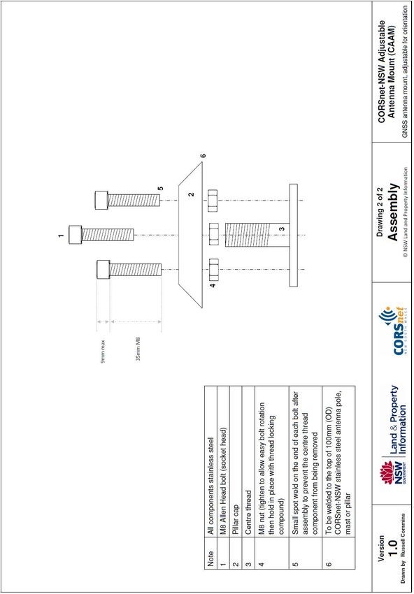
DOCUMENT CONTROL SHEET

Contact for Enquiries and Proposed Changes
If you have any questions regarding this document, contact:

Designation:     Document Sponsor                  Designation:      Editing Author

Name:            Doug Kinlyside                    Name:             Simon McElroy

Phone:           +61 (0)2 6332 8372                Phone:            +61 (0)2 6332 8300

Fax:             +61 (0)2 6332 8366                Fax:              +61 (0)2 6332 8479

Email:           Doug.Kinlyside@lpi.nsw.gov.au     Email:            Simon.McElroy@lpi.nsw.gov.au

Record of Document Issues
 Version No     Issue Date      Nature of Amendment
     1.0        18/07/2011      Final approval and public distribution

Document Distribution
      Name                 Organisation          Distribution Channel
   General Public               -                CORSnet-NSW website

Document Approval
Approved by:

...........................................
Doug Kinlyside
Manager, Survey Infrastructure & Geodesy
Date of Approval: 18 July 2011

LPI welcomes feedback on these guidelines. For details, see Maintenance of Guidelines on page 7.

Land and Property Information (LPI)
Guidelines for CORSnet-NSW Continuously Operating Reference Stations (CORS)                    page ii
Version 1.0
Table of Contents
TERMS AND DEFINITIONS ............................................................... 1

FOREWORD ...................................................................................... 6

1      THE GNSS CORS HIERARCHY .................................................... 9

    1.1    Tier 1 GNSS CORS ............................................................................. 9

    1.2    Tier 2 GNSS CORS ............................................................................. 9

    1.3    Tier 3 GNSS CORS ........................................................................... 10

    1.4    Tier 4 GNSS CORS ........................................................................... 10

    1.5    Tier 5 GNSS CORS ........................................................................... 10

2      GNSS CORS NETWORK DESIGN ............................................... 16

3      GNSS CORS ESTABLISHMENT ................................................. 18

    3.1    Pre-installation Data Quality Assessment ............................................ 18

    3.2    Signal Quality.................................................................................. 19

          3.2.1   Sky Visibility....................................................................................... 19
          3.2.2   Multipath ........................................................................................... 19
          3.2.3   Radio Frequency Interference (RFI) Sources: GNSS and Communications .. 20

    3.3    Authorisation to Build ....................................................................... 20

    3.4    Site Access ..................................................................................... 21

    3.5    Site Security ................................................................................... 21

    3.6    Site Stability ................................................................................... 23

          3.6.1   Site Foundation .................................................................................. 23
          3.6.2   Antenna Monument ............................................................................. 23
          3.6.3   Antenna Mounts .................................................................................. 28

    3.7    Occupational Health and Safety ......................................................... 30

    3.8    Power and Communications .............................................................. 31

          3.8.1   Power ................................................................................................ 31
          3.8.2   Communications ................................................................................. 34

    3.9    Standardisation ............................................................................... 36

    3.10 Redundancy .................................................................................... 37

    3.11 Site Maintenance ............................................................................. 37

Land and Property Information (LPI)
Guidelines for CORSnet-NSW Continuously Operating Reference Stations (CORS)                                       page iii
Version 1.0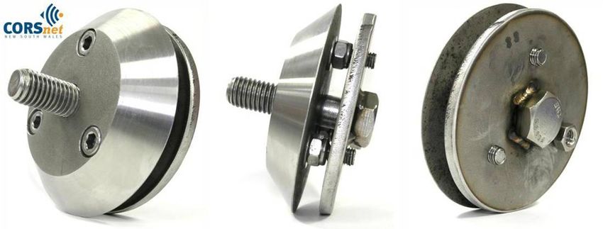
4      GNSS EQUIPMENT................................................................... 39

    4.1    GNSS CORS Receiver ....................................................................... 39

    4.2    GNSS CORS Antenna and Models ....................................................... 41

    4.3    GNSS Antenna Cable ........................................................................ 43

    4.4    Meteorological Sensors ..................................................................... 47

    4.5    Tilt Sensors ..................................................................................... 47

    4.6    Remote Control ............................................................................... 47

    4.7    Lightning Protection ......................................................................... 48

    4.8    Pre Assembly .................................................................................. 48

5      GNSS CORS SITE COORDINATES ............................................. 49

    5.1    Regulation 13 Certification ................................................................ 49

    5.2    Differences between GNSS CORS Coordinates and Ground Mark
           Coordinates .................................................................................... 50

    5.3    Connecting to the Local Control Marks on the National Geodetic Datum .. 51

    5.4    Stability Monitoring .......................................................................... 52

6      GNSS CORS OPERATION ......................................................... 54

    6.1    Operational Status ........................................................................... 54

    6.2    Reliability........................................................................................ 54

    6.3    Data Formats .................................................................................. 54

          6.3.1   Post-Processed Data Formats ............................................................... 54
          6.3.2   Real-Time Data Formats ...................................................................... 56

    6.4    Metadata ........................................................................................ 57

    6.5    Station Naming and Identifiers .......................................................... 57

7      REFERENCES ........................................................................... 60

Appendix 1: Sample Regulation 13 certificate ................................................ 63

Appendix 2: Sample monument design for CORSnet-NSW Tier 1 and Tier 2 GNSS
    CORS ................................................................................................. 65

Appendix 3: Sample monument designs for CORSnet-NSW Tier 3 and Tier 4 GNSS
    CORS ................................................................................................. 66

Appendix 4: CORSnet-NSW Adjustable Antenna Mount (CAAM) design (Australian
    Patent Application No. 2011900458) ...................................................... 69

Land and Property Information (LPI)
Guidelines for CORSnet-NSW Continuously Operating Reference Stations (CORS)                              page iv
Version 1.0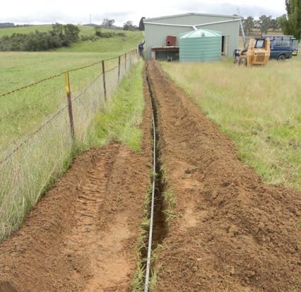
List of Tables
Table 1: Summary of specifications for GNSS CORS tiers in CORSnet-NSW. ......... 11
Table 2: Specifications of a geodetic/CORS quality GNSS receiver. ..................... 40
Table 3: Specifications of a geodetic/CORS quality GNSS antenna. ..................... 42
Table 4: Specifications of a standard GNSS CORS antenna cable. ....................... 45
List of Figures
Figure 1: Enclosure with solar panel doubling as a shade awning at a CORSnet-NSW
site (Tier 2). ................................................................................. 22
Figure 2: Building enclosures at CORSnet-NSW sites (Tier 3). ............................ 22
Figure 3: Typical CORSnet-NSW Tier 2 antenna monuments. ............................. 24
Figure 4: Typical CORSnet-NSW Tier 3 and 4 antenna monuments: (a) free
standing pole, (b) clamp style mount, (c) wall mount, (d) pad style
mount, (e) DSE rooftop style mount. ............................................... 25
Figure 5: Powder-coated antenna monuments at CORSnet-NSW sites (Tier 3), also
showing the use of steel ties, waterproof connectors and partial drip
loops. .......................................................................................... 26
Figure 6: Using Anka screws (top) to hold the monument in position while the
chemical anchors (bottom) cure at a CORSnet-NSW site (Tier 3). ....... 27
Figure 7: Antenna monument with bevelled edge at a CORSnet-NSW site (Tier 3).28
Figure 8: Construction of the GNSS CORS antenna mount at a CORSnet-NSW site
(Tier 2)........................................................................................ 29
Figure 9: GNSS antenna mounts: (a) SCIGN mount, (b) SECO 2072 mount, (c)
UNAVCO mount (UNAVCO, 2011c). ................................................. 29
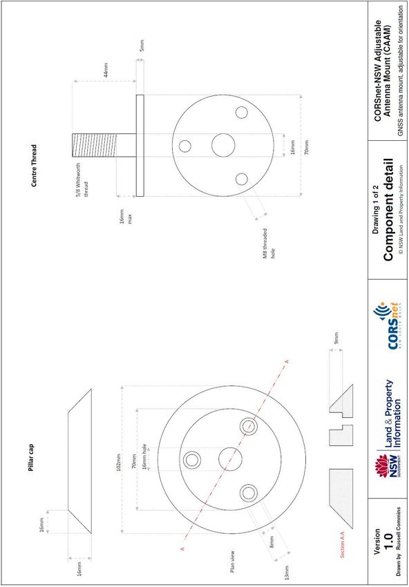
Figure 10: Internal workings of the CORSnet-NSW Adjustable Antenna Mount
(CAAM), patent pending. ............................................................... 30
Figure 11: CORSnet-NSW Adjustable Antenna Mount (CAAM), integrated into the
GNSS antenna monument. ............................................................. 30
Figure 12: (a) DSE-style harness attachment point and ladder bracket, and (b)
elevated pole monument with harness attachment point and ladder rest
at a CORSnet-NSW site (Tier 3). ..................................................... 31
Figure 13: Handrail installed around the base of a CORSnet-NSW site (Tier 3). .... 31
Figure 14: GNSS CORS pillar, automatic weather station and solar power with
backup battery power installation at a CORSnet-NSW site (Tier 2). ..... 34
Figure 15: Labelled circuit breakers at a CORSnet-NSW site (Tier 2). .................. 36
Land and Property Information (LPI)
Guidelines for CORSnet-NSW Continuously Operating Reference Stations (CORS) page v
Version 1.0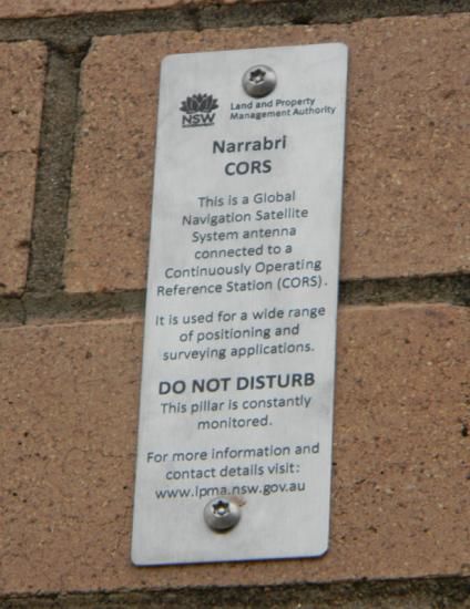
Figure 16: GNSS antenna cable and conduit being buried at a CORSnet-NSW site
           (Tier 3)........................................................................................ 44

Figure 17: Observed position vs. official position for Goulburn CORS (Tier 3). ...... 53

Figure 18: (a) RM survey being conducted during installation of a CORSnet-NSW
           site (Tier 2) before the GNSS antenna is installed, and (b) one of the
           reference marks placed for Tier 2 sites. ........................................... 53

Figure 19: Monument inscriptions for Tuross Head CORS (Tier 2) and Narrabri
           CORS (Tier 3). .............................................................................. 58

Land and Property Information (LPI)
Guidelines for CORSnet-NSW Continuously Operating Reference Stations (CORS)                          page vi
Version 1.0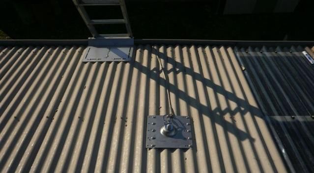
Terms and Definitions
For the purpose of these guidelines, the following terms and definitions shall apply:

Term/Acronym                Definition

AFN                         Australian Fiducial Network – eight permanent,
                            continuously operating, geodetic GNSS receivers on the
                            Australian mainland and Tasmania, initially observed
                            during the International GNSS Service 1992 campaign.
                            The coordinates of the AFN sites, based on ITRF92 at
                            epoch 1994.0, were published in the Government Gazette
                            as the official realisation of the GDA94 datum.

APC                         Antenna Phase Centre – the point inside a GNSS antenna
                            to which all GNSS signals are measured. As this point
                            cannot be physically measured to, measurements are then
                            referred to the Antenna Reference Point (ARP) using known
                            offsets between the APC and the ARP.

APREF                       Asia-Pacific Reference Frame – a project to create and
                            maintain an accurate and densely realised geodetic
                            framework in the Asia-Pacific region, based on continuous
                            observation and analysis of GNSS data.

ARP                         Antenna Reference Point – the physically accessible point
                            on a GNSS antenna to which all measurements related to
                            that antenna are referred.

CMR+                        Compact Measurement Record (Plus) – manufacturer’s
                            proprietary format for real-time data developed by Trimble
                            Navigation. It is the default industry standard in precision
                            agriculture and machine guidance, and widely accepted by
                            third party GNSS manufacturers.

AHD71                       Australian Height Datum 1971 – the national vertical
                            datum of Australia.

CORS                        Continuously Operating Reference Station – a permanent,
                            continuously operating GNSS receiver and antenna,
                            mounted on a stable monument with reliable power supply
                            and communications infrastructure.

CORSnet-NSW                 A rapidly growing network of GNSS CORS providing
                            fundamental positioning infrastructure for New South
                            Wales (NSW) that is accurate, reliable and easy to use
                            (http://www.corsnet.com.au/).

Land and Property Information (LPI)
Guidelines for CORSnet-NSW Continuously Operating Reference Stations (CORS)        page 1
Version 1.0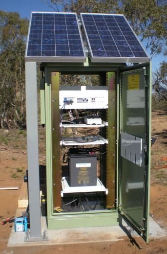
Term/Acronym                Definition

DGPS/DGNSS                  Differential GPS / Differential GNSS – a sub-metre, code-
                            based, real-time positioning technique or service.

DOMES                       Directory of MERIT Sites – historically, the DOMES
                            numbering system was designed at the start of the MERIT
                            campaign in the early 1980s in order to give an
                            unambiguous identifier to all instrument reference points
                            and markers involved in the campaign. This information
                            was first published by the Bureau International de l’Heure
                            (BIH). Since the official start of the International Earth
                            Rotation and Reference Systems Service (IERS) in 1988, a
                            DOMES number has been issued for all stations
                            contributing to the ITRF.

elevation mask              A GNSS receiver setting that determines whether GNSS
                            signals are not recorded below a certain angle above the
                            horizon.

GDA94                       The Geocentric Datum of Australia 1994, realised by the
                            coordinates of the Australian Fiducial Network (AFN)
                            geodetic stations, referred to the GRS80 ellipsoid and
                            determined within the International Terrestrial Reference
                            Frame 1992 (ITRF92) at the epoch of 1994.0.

geodetic datum              An official, fully-defined, spatial reference system to which
                            coordinates are referred in either one, two, three or four
                            dimensions.

GNSS                        Global Navigation Satellite System – the family of current
                            and future satellite navigation systems, including GPS,
                            GLONASS, Beidou/Compass, Galileo and others.

IGS                         International GNSS Service – an international federation of
                            agencies that pool resources to operate a global CORS
                            network whose data is used, amongst other purposes, to
                            generate precise GNSS products in support of Earth science
                            research, as well as multi-disciplinary applications
                            (http://igs.org/).

ITRF                        International Terrestrial Reference Frame – a realisation of
                            the International Terrestrial Reference System (ITRS),
                            produced by the International Earth Rotation and
                            Reference Systems Service (IERS). A new ITRF, based on
                            the latest data and analysis, is published every few years.
                            More information is available at http://itrf.ensg.ign.fr/.

Land and Property Information (LPI)
Guidelines for CORSnet-NSW Continuously Operating Reference Stations (CORS)         page 2
Version 1.0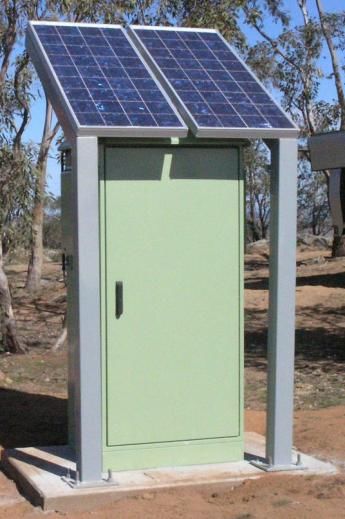
Term/Acronym                Definition

LPI                         Land and Property Information – a division of the NSW
                            Department of Finance & Services. LPI builds, owns and
                            operates CORSnet-NSW and is responsible for the
                            maintenance of this document.

multipath                   Errors in GNSS observations caused by one or more
                            reflected GNSS signals interfering with the direct GNSS
                            signal because of their common time origin but different
                            path lengths.

NCC                         Network Control Centre – location that houses all
                            communication and IT infrastructure and software systems
                            to operate, monitor and manage a CORS network.

NMS                         Network Management System – a combination of hardware
                            and software that monitors physical hardware (e.g.
                            modems, UPS, batteries) within a CORS network.

NRTK                        Network Real Time Kinematic – centimetre-level, carrier
                            phase-based, real-time positioning technique or service,
                            relative to a network of GNSS reference stations.

NTRIP                       RTCM-SC10410 - Networked Transport of RTCM via
                            Internet Protocol (NTRIP) is an application-level protocol
                            for streaming RTCM-10403 formatted GNSS data over the
                            Internet. Details of this standard can be found at
                            http://www.rtcm.org & http://igs.bkg.bund.de/ntrip/about.

PDU                         Power Distribution Unit – a device that manages the
                            distribution of power to network components.

reference frame             A geodetic reference system is a set of definitions and
                            mathematical models that allow geodetic measurements to
                            be related to each other in a systematic fashion. A
                            reference frame is the physical realisation of a reference
                            system. Current global reference frames basically consist
                            of a set of point coordinates at a reference epoch and
                            constant velocity vectors for each point.

Land and Property Information (LPI)
Guidelines for CORSnet-NSW Continuously Operating Reference Stations (CORS)       page 3
Version 1.0
Term/Acronym                Definition

Reg 13                      Regulation 13 – The process of verification of a reference
                            standard of a position-measurement in accordance with
                            Regulation 13 of the National Measurement Regulations
                            1999 and the National Measurement Act 1960. Through
                            this process, Geoscience Australia certifies the position of a
                            GNSS CORS, stated on the Regulation 13 certificate.

RFI                         Radio Frequency Interference – interference of GNSS
                            signals in the presence of other radio frequency signals,
                            causing an adverse effect on the GNSS signals recorded at
                            a site. Common sources of RFI can include radio and
                            television towers, microwave data links, power lines or
                            transformers, and mobile phone towers.

RINEX                       Receiver INdependent Exchange – an internationally
                            accepted format for the exchange of GNSS data between
                            software applications and for GNSS data archiving. Details
                            of this format can be found at ftp://ftp.unibe.ch/aiub/rinex.

RTCM                        Radio Technical Commission for Maritime Services –
                            Special Commission 104 is responsible for international
                            standards of radio communication and navigation using
                            differential GNSS. Details of these standards can be found
                            at http://www.rtcm.org.

RTK                         Real Time Kinematic – centimetre-level, carrier phase-
                            based, real-time positioning technique or service, relative
                            to a single GNSS reference station.

SCIMS                       Survey Control Information Management System –
                            database containing coordinates and related metadata
                            information for survey marks established under the
                            direction of the NSW Surveyor General. SCIMS is
                            maintained by Land and Property Information (LPI) for the
                            purposes of cadastral boundary definition, engineering
                            surveys, mapping and a variety of other spatial
                            applications.

SNR                         Signal-to-Noise Ratio – an assessment of the strength of a
                            signal as a ratio compared against background noise.

survey control mark         A mark, with associated coordinates, uncertainties and
                            relevant metadata that is a physical realisation of one or
                            more of the recognised Australian geodetic datums.

Land and Property Information (LPI)
Guidelines for CORSnet-NSW Continuously Operating Reference Stations (CORS)         page 4
Version 1.0
Term/Acronym Definition
tier A term used to differentiate GNSS CORS sites based on
their primary purpose, reliability, stability, permanency and
GNSS products/services.
UNAVCO University NAVSTAR Consortium – a non-profit,
membership-governed university consortium facilitating
geoscience research and education using geodesy
(http://www.unavco.org/).
UPS Uninterruptible Power Supply – an electrical device that
provides short-term power to devices when the primary
power supply fails.
Land and Property Information (LPI)
Guidelines for CORSnet-NSW Continuously Operating Reference Stations (CORS) page 5
Version 1.0Foreword Introduction The introduction of ―active‖ Continuously Operating Reference Stations (CORS) based on Global Navigation Satellite System (GNSS) technology has revolutionised the delivery of the geodetic datum in Australia, shifting away from traditional ―passive‖ ground marks. The use of GNSS CORS for datum delivery is discussed in Active GPS and Survey Marks (ICSM, 2008). In a geodetic context, GNSS CORS form an integral component of the State’s and the nation’s geospatial infrastructure. The primary purpose of geodetic GNSS CORS is to collect data to measure and monitor the movement of the continent so that a ―millimetre‖ accurate reference frame and datum for geoscience and spatial datasets can be defined and maintained. GNSS CORS also support a multitude of downstream applications such as major infrastructure projects, asset management, resource and emergency management, machine guidance, intelligent transport systems, precision agriculture and environmental research. Both government and the private sector are establishing GNSS CORS, often as part of a network, to provide real-time positioning services offering timely, reliable and accurate positioning for these and other applications. CORSnet-NSW is a rapidly growing network of GNSS CORS providing fundamental positioning infrastructure for New South Wales (NSW) that is accurate, reliable and easy to use (Janssen et al. 2010). The network aims to support the spatial community and provide stimulus for innovative spatial applications and research using satellite positioning technology. It provides Differential GNSS (DGNSS/DGPS), single-base Real Time Kinematic (RTK) and Network Real Time Kinematic (NRTK) positioning services, and RINEX data for post-processing applications. CORSnet-NSW is built, owned and operated by Land and Property Information (LPI), a division of the NSW Department of Finance & Services. Acknowledging that other reference station providers (both government and private) may need to establish and operate CORS and co-exist in the State, CORSnet-NSW forms the backbone of datum realisation for all spatial applications in NSW, ensuring seamless, consistent and accurate positioning across the State. LPI encourages the inclusion of all other suitable reference stations in its network, including in areas already serviced by CORSnet-NSW, to ensure redundancy and continuation of services. It is recognised that clear guidance and practical coordination is required to build an effective partnership model for technical cooperation in GNSS CORS networks across the State. This document provides such technical guidance. CORSnet-NSW user guidelines and additional information on best practice can be found in the Reference Material section of the CORSnet-NSW website (LPI, 2011). Purpose of Guidelines These guidelines provide recommendations for the technical design, installation, operation and maintenance of GNSS CORS used in CORSnet-NSW with the objective of ensuring interoperable GNSS CORS across New South Wales. It is Land and Property Information (LPI) Guidelines for CORSnet-NSW Continuously Operating Reference Stations (CORS) page 6 Version 1.0
anticipated that these guidelines may be adopted by other CORS network operators
and may become a national standard.

The provision of these guidelines demonstrates LPI’s commitment to the national
positioning infrastructure (NPI) policy, and supports its goal to ―ensure the
sustainable, nationally compatible deployment of GNSS CORS infrastructure capable
of accommodating a variety of providers and ensuring an efficient and effective
Australia-wide coverage and service for the positioning needs of a diverse user
community‖.

It is acknowledged that separate guidelines may exist for other Ground Based
Augmentation Systems (GBAS) in Australia. One such GBAS is the GPS beacon
system of the Australian Maritime Safety Authority (AMSA), which transmits
differential GPS (DGPS) signals approximately 150 nautical miles out to sea. A
second example is an aviation-specific GBAS operating at Sydney airport as one of
the first such systems in the world. These standalone systems are not part of
CORSnet-NSW and are beyond the scope and intention of this document.

Brief History of Guidelines
This document contains new guidelines.

Acknowledgements
These guidelines are based on invaluable initial work undertaken by the
Intergovernmental Committee on Surveying and Mapping (ICSM) Geodetic
Technical Sub-Committee (GTSC). In particular, Darren Burns (Department of
Environment and Resource Management, Queensland) and Robert Sarib
(Department of Lands and Planning, Northern Territory) are gratefully
acknowledged for their contribution to the early development of a generic,
unpublished, national document.

The incomplete generic ICSM-GTSC document has been revived, extensively
reviewed, modified and expanded to meet the needs of CORSnet-NSW by the
following LPI staff:

    Mr Simon McElroy

    Dr Volker Janssen

    Mr Russell Commins

    Mr Thomas Yan

Maintenance of Guidelines
The maintenance of these guidelines is the responsibility of Land and Property
Information (LPI), a division of the NSW Department of Finance & Services.
Updates will be required when Initial Operational Capability (IOC) is declared for
new GNSS and GPS modernisation. In the future, it is intended to include
CORSnet-NSW guidelines regarding reliability and service levels. Please direct

Land and Property Information (LPI)
Guidelines for CORSnet-NSW Continuously Operating Reference Stations (CORS)   page 7
Version 1.0
feedback and report any broken links to Simon McElroy at
Simon.McElroy@lpi.nsw.gov.au.
Referencing of Guidelines
These guidelines are available on the CORSnet-NSW website and should be
referenced as follows:
LPI (2011) Guidelines for CORSnet-NSW Continuously Operating Reference Stations
(CORS), version 1.0, available via
http://www.lpma.nsw.gov.au/survey_and_maps/corsnet-nsw/reference_material
(accessed Month Year).
Land and Property Information (LPI)
Guidelines for CORSnet-NSW Continuously Operating Reference Stations (CORS) page 8
Version 1.01 The GNSS CORS Hierarchy
In order to distinguish Global Navigation Satellite System (GNSS)
Continuously Operating Reference Station (CORS) networks in regards to
their purpose, the concept of a tiered hierarchy of permanent GNSS
reference stations was proposed by Rizos (2007) and has since been widely
accepted across Australia (Burns & Sarib, 2010). This original hierarchy has
been adopted and expanded as the basis for differentiating between GNSS
CORS throughout this document, with the addition of Tier 4 and 5. The tier
status of a GNSS CORS is principally determined by:
The primary purpose for which the station has been established.
The expected reliability and services from the station.
The expected stability of the station monument.
The expected permanency of the station.
The ultimate responsibility for the assignment of a tier classification to a
station included in CORSnet-NSW must remain within the subjective
judgement of LPI as the relevant authority. CORSnet-NSW currently (at the
date of issue of these guidelines) consists of GNSS CORS classified as Tier 1-
3. LPI may consider inclusion of Tier 4 and 5 classified GNSS CORS where
appropriate.
1.1 Tier 1 GNSS CORS
Tier 1 GNSS CORS require high-stability monuments to support long-term,
geoscientific research and global reference frame definition. These sites are
established to support the International GNSS Service (IGS) or other
equivalent ultra-high accuracy networks. The IGS site guidelines (IGS,
2009) provide guidelines for all GNSS CORS sites contributing data to IGS,
and additional requirements for the IGS reference frame sites, which are a
subset of IGS sites used to determine the International Terrestrial Reference
Frame (ITRF). Data from Tier 1 GNSS CORS should be submitted to IGS for
global geodetic science and research purposes.
Tier 1 GNSS CORS are owned and operated by the federal government
(primarily Geoscience Australia). Their operation tends to be focused on
post processing (RINEX data). Tier 1 GNSS CORS are included in CORSnet-
NSW if additional, primarily real-time focused, requirements are met.
1.2 Tier 2 GNSS CORS
Tier 2 GNSS CORS require high-stability monuments, usually established by
national (i.e. Geoscience Australia) and/or state geodetic agencies for the
purpose of maintaining national geodetic reference frames. These sites are
operated long term and form the primary national GNSS network. It should
be noted that Tier 2 GNSS CORS provide a tie between the national geodetic
datum and the global ITRF. The design and construction methodology
across Tier 2 sites is very similar. Data from Tier 2 GNSS CORS is made
available to the relevant national, state or territory jurisdiction for the
Land and Property Information (LPI)
Guidelines for CORSnet-NSW Continuously Operating Reference Stations (CORS) page 9
Version 1.0purpose of national geodetic reference frame realisation/improvement and
satellite positioning services.
Tier 2 GNSS CORS located in NSW are built, owned and operated by LPI to
support the federal Collaborative Research Infrastructure Strategy (NCRIS).
They are included in CORSnet-NSW if additional, primarily real-time focused,
requirements are met and to ensure a link to the national datum.
1.3 Tier 3 GNSS CORS
Tier 3 GNSS CORS require stable monuments and are established by
national or state government agencies, commercial agencies and companies
specialising in CORS service provision. They are established for the purpose
of densification of the national GNSS CORS network and supporting real-
time positioning applications. These stations generally operate in, and
provide access to, the datum rather than defining it. The design and
construction methodology across Tier 3 sites is similar.
NSW Tier 3 GNSS CORS make up the majority of the CORSnet-NSW
infrastructure. They are predominately built, owned and operated by LPI,
and are often located or ―hosted‖ at local government buildings.
1.4 Tier 4 GNSS CORS
Tier 4 GNSS CORS are established by local government, smaller government
agencies and smaller commercial agencies operating up to a few GNSS
reference stations in the medium term (3-7 years) for the purpose of
supporting satellite-positioning needs to a group of local users with similar
requirements. Monumentation, service levels, reliability and backup systems
satisfy the internal user group. The design and construction methodology
across Tier 4 sites can be varied.
Tier 4 GNSS CORS may be included in CORSnet-NSW to provide
densification and avoid the duplication of service that would occur with the
establishment of a new Tier 3 site by LPI. They can provide vital,
independent backup to primary stations (Tier 3 GNSS CORS).
1.5 Tier 5 GNSS CORS
Tier 5 GNSS CORS are established by small private business or
individuals, providing an ―ad-hoc‖ service for short-term project (Table 1: Summary of specifications for GNSS CORS tiers in CORSnet-NSW.
Specification for Tier 1 Tier 2 Tier 3 Tier 4 Tier 5
Life Span
■ ■ ■ □ □
Operational life and site tenure (>50 yrs) (>30 yrs) (>15 yrs) (>5 yrs) (>1 yr)
Primary Purpose
Datum definition (global), international
■ □ X X X
GNSS services and geodynamic studies
Datum definition (regional/national/state) ■ ■ □ X X
Datum densification – spine/sub-spine
□ ■ ■ □ X
survey mark (state)
―Active‖ control station/reference station
□ ■ ■ □ □
(e.g. LGA)
Real-time positioning services – CORS
□ ■ ■ □ X
network covering area (e.g. state or LGA)
Real-time positioning services – single
CORS covering localised area (e.g. port, □ □ ■ ■ □
airport, mine, construction site, farm)
Geodynamic monitoring (tide gauges) □ ■ □ X X
Other (timing, monitoring, applied
□ □ □ □ □
research, etc.)
Typical Ownership
Federal government ■ □ □ N/A N/A
State government □ ■ ■ □ N/A
Local government X □ ■ ■ □
CORS service provider X □ ■ ■ □
Large business X □ ■ ■ □
Small business or individual X X □ ■ ■
Service Level
Data complete and continuous – post ■ ■ ■ ■ □
processing (raw or RINEX) (>99%) (>99%) (>95%) (>90%) (>75%)
Data complete and continuous – real time □ ■ ■ ■ □
(raw or RTCM) (>90%) (>95%) (>95%) (>90%) (>75%)
Service Type
Provision of ―centimetre‖ network-based ■ ■ ■ □ X
services (NRTK and/or Virtual RINEX) (primary) (primary) (primary) (backup)
Provision of ―sub-metre‖ network-based ■ ■ ■ □ X
services (DGPS) (primary) (primary) (primary) (backup)
Provision of ―centimetre‖ single-CORS- ■ ■ ■ □ □
based services (RTK and/or RINEX) (primary) (primary) (primary) (backup) (backup)
Provision of ―sub-metre‖ single-CORS- ■ ■ ■ ■ □
based services (DGPS) (primary) (primary) (primary) (primary) (backup)
Land and Property Information (LPI)
Guidelines for CORSnet-NSW Continuously Operating Reference Stations (CORS) page 11
Version 1.0Specification for Tier 1 Tier 2 Tier 3 Tier 4 Tier 5
Monitoring service performance □ □ □ □ □
Foundation
Permanently fixed to bedrock or deep
■ ■ □ □ □
(>3m) concrete base
Permanently keyed into more competent
■ ■ □ □ □
rock through layers of soil / fractured rock
Permanently mounted on concrete base
(>0.5m3) or solid building that is only X X ■ ■ □
subject to minimal seasonal movement
Permanently mounted on semi-rigid
structure (e.g. steel shed, hangar, tower)
X X X ■ ■
that may be subject to some shorter-term
movement or vibration
Monumentation
Dual reinforced concrete pillars or dual
braced deep-drilled frames (i.e. dual □ □ N/A N/A N/A
antenna mounts)
Single reinforced concrete pillar or braced
■ ■ □ □ □
deep-drilled frame
Rigid stainless steel or galvanised steel
mounts permanently attached to building X X ■ ■ □
or concrete plinth
Adjustable, semi-rigid, long (braced if
>2m), temporary or ―ad-hoc‖ mount X X X X ■
subject to vibration movement of 0-5º (>5-15º (>15º (>20º
elev) elev) elev) elev) elev)
■ ■ ■ □
Minimal multipath at site (~ zero) (~ zero) (minimal) (low)
□
■ ■ ■ □
Minimal RFI at site (~ zero) (~ zero) (minimal) (low)
□
Security
Access to antenna restricted (e.g.
□ □ □ □ □
elevated site, roof, locked fence)
Land and Property Information (LPI)
Guidelines for CORSnet-NSW Continuously Operating Reference Stations (CORS) page 12
Version 1.0Specification for Tier 1 Tier 2 Tier 3 Tier 4 Tier 5
Access to receiver and peripheral devices
restricted (e.g. locked cabinet, secure IT ■ ■ ■ ■ □
server room)
Power
Ensured continuous operation of GNSS
■ ■ ■ ■ □
receiver
Ensured continuous operation of all
□ ■ ■ ■ □
communications devices
Alternate power supply providing ■ ■ ■ ■
operation for specified time period (office (>20 (>20 (>5 (>5 □
location) days) days) hours) hours)
Alternate power supply providing ■ ■ ■ ■
operation for specified time period (>20 (>20 (>40 (>10 □
(remote location) days) days) hours) hours)
Communications
Remote control and data access supported □ ■ ■ ■ ■
Reliable and continuous, with a latency of
less than 2 seconds from CORS to end ■ ■ ■ ■ ■
user (for real-time positioning services)
Backup/alternate communications device
□ ■ ■ □ □
installed
GNSS Receiver
Geodetic/CORS grade quality ■ ■ ■ □ □
Survey/Construction/Precision Agriculture
X X X ■ ■
grade quality
Ability to store and remotely download ■ ■ ■ □
raw 1-second GNSS data for at least a (>60 (>60 (>30 (>15 □
specified number of days days) days) days) days)
Ability to store and remotely download at ■ ■ □
least a specified number of days of raw (>60 (>60 (>30 N/A N/A
meteorological data days) days) hours)
RTCM 10403.1 or suitable alternative data
format for real-time data streaming at 1- □ ■ ■ ■ □
second or better
Tracks existing GPS observables (L1 & L2) ■ ■ ■ ■ ■
Tracks, or is upgradable to track, GPS L2C ■ ■ ■ □ □
Tracks, or is upgradable to track, GPS L5 ■ ■ ■ □ □
Tracks existing GLONASS observables ■ ■ ■ ■ □
Tracks, or is upgradable to track,
□ □ □ □ □
proposed GLONASS observables
Tracks, or is upgradable to track, free-to-
□ □ □ □ □
air Galileo observables
Land and Property Information (LPI)
Guidelines for CORSnet-NSW Continuously Operating Reference Stations (CORS) page 13
Version 1.0Specification for Tier 1 Tier 2 Tier 3 Tier 4 Tier 5
Tracks, or is upgradable to track,
□ □ □ □ □
Beidou/Compass observables
Tracks, or is upgradable to track, QZSS
□ □ □ □ □
observables
Dedicated network (Ethernet) port
supporting multiple data streams ■ ■ ■ ■ ■
simultaneously
Receiver bias model available in CORS
■ ■ ■ ■ ■
network management software
GNSS Antenna
Geodetic/CORS grade quality ■ ■ ■ □ □
Survey/Construction/Precision Agriculture
X X X ■ ■
grade quality
Choke ring antenna with high-quality (e.g.
■ ■ □ □ □
Dorne Margolin) element
Multipath mitigation ■ ■ ■ ■ ■
IGS ―individual‖ calibrated absolute
□ □ □ N/A N/A
antenna phase centre model available
IGS ―type‖ calibrated absolute antenna
■ ■ ■ ■ ■
phase centre model available
Antenna orientated to True North (±5°) ■ ■ ■ ■ □
Weather Station
Pressure measurement accuracy better
■ ■ □ □ □
than ±0.1hPa
Temperature measurement accuracy
■ ■ □ □ □
better than ±1°C
Relative humidity measurement accuracy
■ ■ □ □ □
better than ±2%
Coordinates
Provisional coordinates in national
geodetic datum, derived by 24-hour ■ ■ ■ ■ ■
datasets processed via AUSPOS
Final coordinates in national geodetic
datum, derived by Geoscience Australia ■ ■ ■ ■ ■
via Regulation 13 certification
Final local GDA94(1997) and AHD71
coordinates, derived by LPI approved □ ■ ■ ■ □
survey and available in SCIMS
Position Monitoring
Periodic (6-24 month) high-precision,
□ ■ □ □ N/A
local terrestrial reference mark surveys
Land and Property Information (LPI)
Guidelines for CORSnet-NSW Continuously Operating Reference Stations (CORS) page 14
Version 1.0Specification for Tier 1 Tier 2 Tier 3 Tier 4 Tier 5
Continuous (daily solutions) monitoring
■ ■ ■ ■ □
with scientific software
Continuous (real-time) monitoring within
■ ■ ■ ■ ■
CORS network management software
Hardware Monitoring
Continuous GNSS receiver monitoring
within CORS Network Management ■ ■ ■ ■ ■
System (NMS)
Continuous peripheral device monitoring
with Network Management System (NMS), N/A □ □ □ □
e.g. UPS, modems, battery status, alarms
Accepted Data Format (Post Processing)
Raw proprietary (unsmoothed) format for
■ ■ □ □ □
archiving
RINEX (via receiver memory) for ultra-
■ ■ □ □ □
precise post processing
RINEX (via decoded RTCM stream) for
■ ■ ■ ■ □
general post processing
Accepted Data Format (Real Time)
RTCM 10403.1 or suitable alternative data
■ ■ ■ ■ ■
format for real-time applications
Access to real-time data stream (no
■ ■ ■ □ □
antenna model applied)
Access to real-time data stream (null
X X X □ □
antenna model applied)
Access to real-time data stream (directly
□ □ □ □ □
from receiver)
Access to real-time data stream (relayed
□ □ □ □ □
via a third-party NCC)
Metadata
Complete and current IGS site log ■ ■ ■ ■ ■
Readily available site metadata ■ ■ ■ ■ ■
DOMES number assigned ■ ■ ■ ■ □
Unique 4-character site ID (global) ■ ■ □ □ □
Unique 4-character site ID (Australasia) ■ ■ ■ ■ □
Legend
■ – Mandatory
□ – Optional (preferred if possible)
X – Not permitted
N/A – Not applicable
Land and Property Information (LPI)
Guidelines for CORSnet-NSW Continuously Operating Reference Stations (CORS) page 15
Version 1.02 GNSS CORS Network Design
There are a number of major principles to consider when designing GNSS
CORS networks:
Inter-station distance or station density.
Connection to the reference frame through the GNSS CORS tiers.
The reliability and integrity of services to be provided and the risk of
systems failure that is acceptable, i.e. the effect of station(s) outage on
the delivery of a service.
Type of service(s) to be provided. These range from sparse CORS
networks for DGPS applications, to clusters of 5-6 CORS for NRTK, to
those specifically designed to monitor a structure (e.g. bridge, freeway
construction) or natural feature (e.g. earthquake fault line).
The area over which the service(s) are required. Existing high-
population areas, regions experiencing rapid population growth or rural
locations adopting precision agriculture may require a different sub-
network design to that portion of a network that may cover low
population areas and/or low commercial returns (e.g. remote regions,
national parks and offshore waters).
Whether the network is post-processing or real-time orientated. Real-
time networks that use Ultra High Frequency (UHF) radio as the primary
communications to rovers will need to consider Line of Sight (LOS),
hence terrain and radio ranges, during network design. Real-time
networks relying on the Internet for data transfer will need to consider
the availability of mobile communications coverage.
Networks designed for NRTK often require multiple CORS far beyond the
desired area of operation to allow the modelling of atmospheric effects.
Overseas (UK) studies indicate that NRTK services designed for
mountainous regions may require CORS to be established at different
altitudes, requiring the installation of further CORS (Edwards et al.,
2010).
The level of rover monitoring that is desired. Additional CORS that mimic
a rover (i.e. that do not contribute to actual service delivery) are
routinely established throughout a network to allow the CORS operator
to monitor typical service performance being experienced by users.
Networks providing dual or triple constellation services may opt for
technological solutions (e.g. ―sparse GLONASS‖) that allow them to
alternate between the use of single and multiple constellation GNSS
receiver hardware in their network design.
The proximity to existing CORS operated by other providers and the level
of infrastructure sharing that is available.
Land and Property Information (LPI)
Guidelines for CORSnet-NSW Continuously Operating Reference Stations (CORS) page 16
Version 1.0The desired lifetime over which the CORS network is required to operate,
i.e. short term for a project (e.g. freeway build) or permanent (e.g.
datum realisation).
The collocation of CORS hardware with other geodetic (e.g. tide gauges,
gravity sites or seismic stations), meteorological (Bureau of Meteorology)
or research infrastructure. Similarly, the potential for government
operators to use regional offices, local councils or state government
office blocks and the private sector to use partner and dealer offices.
Based on the current status of GNSS technology, indicative inter-station
distances of GNSS CORS are as follows:
Tier 1 GNSS CORS should have a typical inter-station distance of
between 500 and 1500 kilometres or less.
Tier 2 GNSS CORS should have a typical inter-station distance of
between 90 and 500 kilometres or less.
Tier 3 and Tier 4 GNSS CORS should have a typical inter-station distance
of between 20 and 90 kilometres or less.
Tier 5 GNSS CORS are established on an opportunity basis, either as an
autonomous (standalone) CORS located central to the intended area of
operation or as a cluster of several CORS. A suggested inter-station
distance is therefore not applicable.
These inter-station distances assume negligible outages. Operators
requiring greater reliability or redundancy should decrease these values,
hence increasing network density.
A nominal 10% of stations in a GNSS CORS network should be constructed
to the standards of the next highest tier to provide a stronger link between
sites in the GNSS CORS network and the national and international reference
frame, and to improve national geodetic datum accuracy.
Modern real-time positioning software is generally able to tolerate a single
GNSS CORS outage in the middle of a network and continue to function,
albeit with a possible small accuracy deterioration. However, when a site on
the perimeter of a real-time positioning network suffers a hardware,
communications or power failure, service in that area may be disrupted. To
reduce the possibility of service disruption, a greater density of GNSS CORS
sites around the network perimeter should be considered. Alternatively, the
area with guaranteed continuous NRTK coverage can be reduced.
Particular care should be taken to increase the power and communications
reliability at sites that form the perimeter of any GNSS CORS network
offering real-time services.
Land and Property Information (LPI)
Guidelines for CORSnet-NSW Continuously Operating Reference Stations (CORS) page 17
Version 1.03 GNSS CORS Establishment
The tier status of a GNSS CORS will determine the minimum criteria for
many aspects of the site selection process, and accordingly aspects of the
following establishment guidelines are divided into tier categories.
Every potential GNSS CORS will have site-specific issues to resolve. This
document recognises seven general principles for the location and design of
a GNSS CORS:
Safety first – Occupational Health and Safety (OH&S) considerations
during installation and maintenance.
The role of the CORS, e.g. a primary station located at the hub of a
―spoked‖ network, an auxiliary backup station, a CORS on the fringe of a
network or an integrity monitoring station.
Stability of the GNSS antenna foundation, monument and mounting
device.
Quality and completeness of the recorded GNSS signals.
A continuous and reliable power supply.
A reliable communications system (primary and backup) with acceptable
latency and sufficient bandwidth.
GNSS CORS infrastructure that resists the ambient environmental and
security conditions.
Following an initial desktop design process, a site visit to evaluate the
potential GNSS CORS site is essential. Good reconnaissance will allow the
evaluation of candidate sites, identify and record any significant signal
obstructions and suspected multipath and Radio Frequency Interference
(RFI) sources. It will also investigate site access, power, measure cable
runs, test communications availability, and consider general issues of site
security, ownership and arranging local hosts or nominated contact officers.
Reconnaissance should also investigate the potential for future changes to
sky visibility from tree growth and development at adjacent sites. Where
there is a concern about the site foundation, this initial reconnaissance may
also help determine whether additional geophysical or structural analysis is
required to determine site suitability.
3.1 Pre-installation Data Quality Assessment
Ideally, prior to construction, an initial data acquisition process should be
undertaken to test data from a proposed GNSS CORS site. The data should
be analysed for signal reception suitability using GNSS quality assessment
software such as TEQC (UNAVCO, 2011a). Data should be analysed for
signal quality parameters on all observed frequencies. At a minimum, the
analysis should include multipath, the ratio of available to recorded
observations, the number and length of loss-of-lock or cycle-slip events, and
the variation of the Signal-to-Noise Ratio (SNR) with satellite elevation.
Land and Property Information (LPI)
Guidelines for CORSnet-NSW Continuously Operating Reference Stations (CORS) page 18
Version 1.0At proposed Tier 1 and 2 sites, a minimum of 48 hours of data observed at
30-second epochs should be recorded and analysed.
At proposed Tier 3 and 4 sites, a minimum of 24 hours of data observed at
30-second epochs should be recorded and analysed.
Where the GNSS CORS site is to be used as part of a real-time positioning
network, data should be recorded at 1-second epochs.
The initial data acquisition process should be undertaken as closely as
possible to the intended final antenna location. If possible, the equipment to
be used at the GNSS CORS site should be used for the initial data acquisition
process. Equipment settings such as enabled tracking options and elevation
masks should be set the same as those intended for the GNSS CORS
installation.
3.2 Signal Quality
3.2.1 Sky Visibility
GNSS CORS sites should have as few obstructions as possible above the
local horizon. Some obstructions to the South (southern hemisphere
operators) can be tolerated.
Tier 1 and 2 GNSS CORS should have an elevation mask set to 0°.
Tier 3 (and lower) GNSS CORS sites should have an elevation mask set
to match the sky visibility at the site, but not more than 10°.
During initial site reconnaissance, potential future obstructions affecting
sky visibility, e.g. likely tree growth and nearby development, should be
considered and recorded.
3.2.2 Multipath
Multipath is the term used to describe GNSS satellite signals that arrive
at the GNSS antenna having travelled via a number of paths. The signal
arrives once directly from the satellite and then a number of additional
times having reflected off other surfaces.
For all CORS, it is recommended that suspected multipath sources be a
minimum of 20 metres from the GNSS antenna and below 5° elevation.
Sources of multipath can be manmade or natural. Reflective surfaces
such as metal panels and roofing, building walls, metal and mesh
fencing, signs and water bodies are known to provide high levels of
multipath. Trees, especially when the canopy is wet, can also increase
the effect of multipath. These reflective bodies should be avoided at
GNSS CORS sites as much as possible.
CORSnet-NSW uses Trimble Navigation’s VRS3Net CORS network
management software to provide site multipath indicators. Alternatively,
the TEQC software (UNAVCO, 2011a) can be used. Suitable sites will
have pseudorange multipath values less than 0.5 metres, and preferably
Land and Property Information (LPI)
Guidelines for CORSnet-NSW Continuously Operating Reference Stations (CORS) page 19
Version 1.0less than 0.3 metres. Phase multipath values should be 5 millimetres or
less. These values will be indicative only. Valid multipath values may
take a week or more of observations.
3.2.3 Radio Frequency Interference (RFI) Sources: GNSS and
Communications
The GNSS signals received at a GNSS CORS site may suffer interference
in the presence of other radio frequency signals. This interference
causes an adverse effect on the GNSS signals recorded at the site.
Common sources of Radio Frequency Interference (RFI) may include
radio and television towers, microwave data links, power lines and
transformers, and mobile phone towers. Directional transmitters,
particularly microwave data links that point toward the GNSS CORS site,
should be avoided. A simple field test that involves attempting to obtain
a navigation solution and monitoring abnormal GNSS signal strengths at
the candidate site, on a low-cost handheld GPS receiver, can often
identify and rule out heavy RFI environments (e.g. ―radio tower farms‖).
Integer multiples of lower radio frequency may cause harmonic
interference with a GNSS signal. Any proposed radio frequency system
should be checked to minimise RFI. RFI is difficult to identify and a
function of radiated power, amongst other parameters. Defining a safe
distance from a given RFI source is therefore not appropriate. Low-cost,
handheld, battery-operated devices are commercially available to detect
the presence of non-GPS signals and interference broadcasting on the L1
frequency.
RFI may also hamper communications, and hence effective data flows,
from a CORS to the Network Control Centre (NCC) or users (e.g. direct
communication systems employing UHF or mobile phone technology).
Most transmitting antennas utilise the E-plane radiation pattern, which
generally projects the highest signal strength horizontally, not vertically.
Consequently, adding vertical separation between the GNSS antenna and
the transmitting UHF radio antenna will have a much greater impact on
noise reduction than horizontal separation alone (lowering a transmitting
antenna by 1 metre has a similar effect to moving it away 10 metres).
For all GNSS CORS, it is advisable that a potential site be tested to
confirm that RFI sources and transmission paths will not undermine
GNSS performance. Analysis of the test observation data is
recommended. Specialist advice may be required if RFI is suspected at a
site.
3.3 Authorisation to Build
CORS construction, even pre-build geophysical bore hole sampling, may be
governed by a range of state and local planning policies, regulations and
acts including State Environmental Planning Policies (SEPPs) and Local
Environmental Plans (LEPs). In some instances, a Development Application
(DA) may be required. Careful scrutiny of the appropriate and any
associated legislation may include special arrangements for survey marks,
navigation aids and multiple antenna installations.
Land and Property Information (LPI)
Guidelines for CORSnet-NSW Continuously Operating Reference Stations (CORS) page 20
Version 1.0In NSW, CORS operators are required to exercise the due diligence code of
practice for the protection of Aboriginal objects, i.e. it needs to be confirmed
that a proposed CORS in a remote area is not located in an Aboriginal place
and does not disturb a nearby Aboriginal site or object. This should be done
well before geophysical testing and construction begins.
3.4 Site Access
Arrangements regarding emergency and periodic access (e.g. maintenance)
to the GNSS CORS site should be agreed before construction. Details should
include contact officers, contact details (business and/or after hours), access
times (business and/or after hours), costs involved, notification times
required and any special local requirements (e.g. site briefings/inductions,
visitors to hold valid Maritime Security Identification Cards, visitors to be
supervised whilst on site).
The need for emergency site access can be significantly reduced by
equipping the site with appropriate auxiliary support devices such as remote
web relay, Virtual Private Network (VPN) tunnel allowing direct and secure
access to CORS receivers through the firewalls of the host organisation,
Uninterruptible Power Supply (UPS), backup communications link and
surveillance camera. CORS network operators should have appropriate IT
administrative rights to CORS equipment and peripheral devices.
3.5 Site Security
Site security includes protecting the GNSS CORS from theft, vandalism,
weather, lightning and animals. It also includes ensuring long-term tenure.
When a government Tier 1 or Tier 2 GNSS CORS site is established, the
preferred form of land tenure is a survey or trigonometrical station reserve.
However, freehold title, a long-term lease, and easements for access are
effective ways of registering a long-term interest, particularly for privately
owned and government Tier 3 GNSS CORS. Any formal arrangement with a
landowner to secure tenure should ensure the agreement includes an option
for continuance and extension if there is a change of land ownership.
Furthermore, requirements regarding insurances covering both parties
should be clearly noted.
By its nature, a GNSS CORS will be exposed to the weather and the natural
environment. Electronic equipment not contained in a secure building may
require a locked and sealed enclosure (Figure 1) or be placed in a building
enclosure (Figure 2). Enclosures should be rated to industry standards for
protection against ambient conditions. The Bureau of Meteorology
(http://www.bom.gov.au/) should be consulted on the seasonal weather
patterns expected at the proposed GNSS CORS site. Sealed enclosures may
need to include insulation or air conditioning equipment to control
temperature and humidity. Equipment should generally be installed such
that the equipment that is least tolerant of temperature extremes is located
lower in the enclosure.
Solar panels, and other externally mounted equipment, should be designed
and certified to withstand local conditions. Solar panels can also be
mounted and orientated to provide an effective shade awning to protect
Land and Property Information (LPI)
Guidelines for CORSnet-NSW Continuously Operating Reference Stations (CORS) page 21
Version 1.0equipment cabinets from direct sunlight (see Figure 1). Any antenna, power
and communications cables between the enclosure and the monument
should be enclosed in durable conduit and, preferably, buried for protection.
Installers must always ―Dial-Before-You-Dig‖ (http://www.1100.com.au/) to
avoid costly damage to underground pipes and cables. The layout of the
equipment should also be designed to prevent inadvertent disruption during
maintenance.
Ideally, a GNSS CORS site should be as unobtrusive as possible to reduce
attracting unwanted attention. If fencing is used to minimise the risk of
vandalism, theft, stock damage or inadvertent disturbance, the fence should
be below the level of the antenna, or at least 20 metres from the GNSS
antenna, to minimise multipath.
Figure 1: Enclosure with solar panel doubling as a shade awning at a CORSnet-NSW site (Tier 2).
Figure 2: Building enclosures at CORSnet-NSW sites (Tier 3).
Land and Property Information (LPI)
Guidelines for CORSnet-NSW Continuously Operating Reference Stations (CORS) page 22
Version 1.0You can also read