MAORI LANDMARKS ON RIVERSIDE RESERVES - "Nga Tapuwae O Hotumauea" Management Plan
←
→
Page content transcription
If your browser does not render page correctly, please read the page content below

“Nga Tapuwae O Hotumauea”
   MAORI LANDMARKS ON
    RIVERSIDE RESERVES
       Management Plan

          April 2003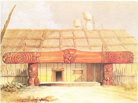
This Management Plan has been
prepared by Hamilton City Council
in partnership with Nga Mana
Toopu O Kirikiriroa Limited
(NaMTOK), Resource and Cultural
Consultants.

“Nga Tapuwae O Hotumauea”
Maori Landmarks on Riverside
Reserves Management Plan

ISBN 0-9582440-0-6

Published by:
Parks and Gardens Unit
Hamilton City Council
Municipal Offices
Garden Place
Private Bag 3010
Hamilton
New Zealand.

Ph 0064 7 8386622

                                    2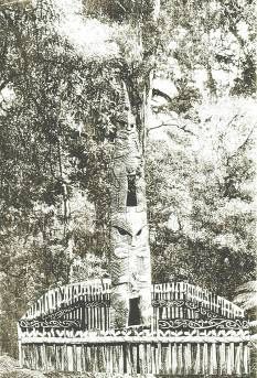
Contents

1.0     Introduction ................................................................................................... 5
1.1      Preparation of this Management Plan............................................................ 5
1.2      The Purpose of this Plan................................................................................ 5
1.3      Introducing the Sites ..................................................................................... 6

2.0     Legislation and Planning Policy Framework .................................................... 6
2.1      Introduction.................................................................................................. 6
2.2      Reserves Act 1977 ........................................................................................ 7
2.2.1    Riverside Reserves Management Plan (1997)................................................. 8
2.3      Resource Management Act 1991 (RMA) ....................................................... 8
2.4      Historic Places Act 1993 ................................................................................ 9
2.5      Hamilton City Proposed District Plan ............................................................. 9
2.5.1    Recreation Environment: ............................................................................. 10
2.5.2    Recreation General: .................................................................................... 10
2.5.3    Recreation Major: ....................................................................................... 10
2.5.4    Overlays: .................................................................................................... 10
2.6      Hamilton’s Strategic Plan 2002-12 .............................................................. 11
2.7      Hamilton’s Recreation and Leisure Plan 2002-2012 ..................................... 12
2.8      Hamilton’s Walkway Strategy ..................................................................... 13

3.0     Objectives and Policies ................................................................................ 14
3.1      Riverside Reserves Management Plan (1997) Objectives and Policies: .......... 14
3.2      Tikanga Maori - Objectives and Policies:...................................................... 15

4.0     Arrival of Europeans at Kirikiriroa ................................................................. 18
4.1      Introduction................................................................................................ 18
4.2      Kirikiriroa: Maori Settlement ........................................................................ 18
4.3      The Waikato Land Wars (1863-1864) ......................................................... 19
4.4      Military settlement in Hamilton ................................................................... 20

5.0     Traditional Pa and Villages ........................................................................... 23
5.1      Definition of Pa, Papakainga, Marae, and Urupa ......................................... 23
5.1.1    Pa............................................................................................................... 23
5.1.2    Papakainga ................................................................................................. 24
5.1.3    Marae ........................................................................................................ 24
5.1.4    Urupa ......................................................................................................... 24
5.2      Construction of Pa along the River .............................................................. 25
5.3      Disputes between Neighbouring Pa ............................................................. 26

6.0     Tangata Whenua .......................................................................................... 28
6.1      Ngati Wairere ............................................................................................. 28
6.2      Ngati Koura ................................................................................................ 29
6.3      Ngati Hanui ................................................................................................ 30
6.4      Ngati Ngamurikaitaua ................................................................................. 31
6.5      Ngati Parekirangi ........................................................................................ 31
6.6      Ngati Iranui ................................................................................................ 31

                                                                                                                           3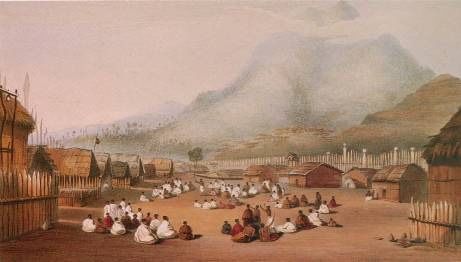
6.7         Ngati Waikai............................................................................................... 32
6.8         Ngati Te Ao ................................................................................................ 32
6.9         Ngati Paretaua ............................................................................................ 32
6.10        Ngati Haumi ............................................................................................... 32

7.0       Maori Landmarks on Riverside Reserves ....................................................... 33
7.1        Te Totara .................................................................................................... 34
7.2        Pukete Pa ................................................................................................... 36
7.3        Te Owhango Pa.......................................................................................... 39
7.4        Matakanohi Pa ........................................................................................... 41
7.5        Te Tupari Pa ............................................................................................... 43
7.6        Waitawhiriwhiri Urupa ................................................................................ 45
7.7        Kirikiriroa Pa ............................................................................................... 47
7.8        Opoia Pa .................................................................................................... 50
7.9        Urupa (Unnamed)....................................................................................... 53
7.10       Te Rapa Pa ................................................................................................. 55
7.11       Te Kourahi Pa ............................................................................................. 59
7.12       Te Moutere O Koipikau Pa .......................................................................... 61
7.13       Te Nihinihi Pa ............................................................................................. 63
7.14       Te Parapara Pa............................................................................................ 65
7.15       Unnamed Pa (Hammond Park).................................................................... 67
7.16       Te Pa O Ruamutu ....................................................................................... 69
7.17       Mangaonua Pa ........................................................................................... 72

References: .............................................................................................................. 74

Appendix 1 – Location Plan .................................................................................... 77

Appendix 2 - Structures found inside Pa.................................................................... 79

Appendix 3 - Protocols for undertaking earthworks ................................................... 84

Appendix 4 – Obituary of Waharoa Te Puke ........................................................... 87

                                                                                                                           4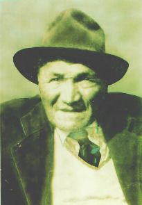
1.0 Introduction
1.1   Preparation of this Management Plan

      Hamilton City Council has prepared this plan in partnership with Nga Mana
      Toopu O Kirikiriroa. Nga Mana Toopu O Kirikiriroa is a coalition of local hapu
      representatives formed in 1995. The committee was mandated by local
      kaumatua (elders) and marae for dealing with Article II issues under the Treaty
      of Waitangi, and all matters pertaining to the Resource Management Act 1991.

      Nga Mana Toopu O Kirikiriroa has the localised knowledge of the land, its
      history, customary values and precepts. Nga Mana Toopu O Kirikiriroa also has
      the ability to identify issues effecting local hapu who hold customary rights as
      Mana Whenua by identifying and providing mitigation solutions. Present day
      Kaumatua of all of the hapu represented in this plan are trustees of Nga Mana
      Toopu O Kirikiriroa. They are:

         •   Mr Hare Puke: Ngati Wairere
         •   Mr John Haunui: Ngati Mahuta
         •   Mr Wiremu Tamihana and Mr Anaru Thompson: Ngati Haua
         •   Mr Wally Clarke: Ngati Koroki
         •   Mr Frank Puhi: Ngati Tamainupo

1.2   The Purpose of this Plan

      This Management Plan has been prepared to assist in the management of
      traditional Maori landmarks. These sites are situated on reserves along the
      Waikato River within Hamilton City boundary.

      All parks administered under the Reserves Act 1977 require a management plan
      under Section 41 of the Act. Hamilton’s riverside reserves have been included
      in the Riverside Reserves Management Plan adopted by Council 1997. That
      management plan suggested that further specificity is required in the
      management of the culturally and historically significant Maori landmarks.

      In 2001 a management plan was prepared under the Reserves Act (1977) for
      Miropiko Reserve. In the Miropiko Reserve Management Plan the reserve was
      identified as a national taonga.     This reserve has unique management
      requirements due to the level of preservation and historical significance of the
      site to local Iwi.

      The remaining riverside landmarks have been included in this management plan.
      The focus of this plan is on the protection and conservation of the
      archaeological, historical and cultural values of the sites in a manner that
      promotes public awareness and knowledge, and accessibility to these sites. This
      plan has been prepared to assist in the day-to-day management of the sites,
      whilst meeting long-term management objectives consistent with those
      developed in the Riverside Reserves Management Plan.

                                                                                    5
1.3   Introducing the Sites

      Nga Mana Toopu O Kirikiriroa has identified seventeen significant riverside
      landmarks within the boundaries of the Hamilton City Council. All of these sites
      were constructed and occupied by the people of Ngati Wairere or its sub-tribes.

      It should be noted that this report only deals with those riverside sites that are
      located within the Hamilton City boundary and on Hamilton City Council
      riverside reserves. Some sites may have been on what is now partly reserve and
      partly private land. However, this plan has no effect on the areas that extend
      over private land.

      The following sites have been identified as traditional Maori Landmarks and
      have been included in this management plan (listed from north to south going
      up the Waikato River) [for location details see Appendix 1 – Location Plan]:

      1.     Te Totara (Featherstone Park)
      2.     Pukete Pa (Braithwaite Park)
      3.     Te Owhango Pa (Te Hikuwai Reserve)
      4.     Matakanohi Pa (Ann Street Reserve)
      5.     Te Tupari Pa (Fairfield Esplanade)
      6.     Waitawhiriwhiri Urupa (Milne Park)
      7.     Kirikiriroa Pa (Kirikiriroa Reserve)
      8.     Opoia Pa (Jesmond Park)
      9.     Urupa (New Memorial Park)
      10.    Te Rapa Pa (Yendell Park)
      11.    Te Kourahi Pa (Yendell Park)
      12.    Te Moutere O Koipikau Pa (Graham Island)
      13.    Te Nihinihi Pa (Dillicar Park)
      14.    Te Parapara Pa (Hamilton Gardens)
      15.    Unnamed Pa (Hammond Park - below Malcolm Street)
      16.    Te Pa O Ruamutu Pa c
      17.    Mangaonua Pa (Mangaonua Esplanade)

2.0 Legislation and Planning Policy Framework
2.1   Introduction

      A hierarchy of legislation and Council strategies and policies provide the
      framework for this management plan. The preparation of management plans
      for reserves is a legislative requirement under the Reserves Act 1977. It sets out
      the management planning process and defines reserves’ purposes and
      functions. This management plan has been prepared consistent with the
      policies set out in the Riverside Reserves Management Plan.

      Other documents have helped shape principles for the protection, use and
      development of reserves. They include:

                 •   Hamilton’s Strategic Plan (Agenda 21 based)
                 •   Resource Management Act 1991
                 •   Historic Places Act 1993

                                                                                      6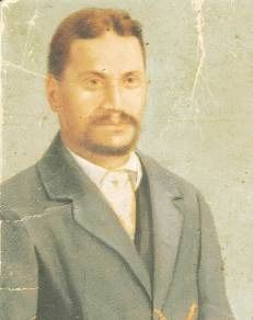
•   Hamilton’s Proposed District Plan
                 •   Hamilton’s Recreation and Leisure Plan (1998-2001)
                 •   Hamilton’s Walkway Strategy (under review)
                 •   Cycling in Hamilton 2000 (Cycling Strategy)

2.2   Reserves Act 1977

      The Reserves Act 1977 (hereafter ‘The Act’) requires Council to…
      “Prepare a management plan for the reserve(s) under its control, management,
      or administration. The management plan shall provide for and ensure the use,
      enjoyment, maintenance, protection, preservation…and development, as
      appropriate of the reserve, for the purposes for which it is classified” (section
      41).

      The reserves included in this plan are classified as either Recreation Reserve
      (under section 17 of the Act), or Local Purpose (esplanade) Reserve (under
      section 23 of the Act).

      The principal purpose of recreation reserves is…
       “To provide areas for the recreation and sporting activities and the physical
      welfare and enjoyment of the public, and for the protection of the natural
      environment…with an emphasis on the retention of open spaces and on
      outdoor recreational activities…”(section 17 (1)).

      The principal purpose of a local purpose (esplanade) reserve is…
      “Providing and retaining areas for such local purpose or purposes as are
      specified in any classification of the reserve”(section 23(1)). A number of the
      reserves contained within this plan are local purpose (esplanade) reserves.
      Though the purpose of esplanade may reflect the means by which the land was
      acquired, and that it is a reserve beside water body, the purposes of esplanade
      reserves under the Resource Management Act 1991 apply irrespective of the
      reserve’s classification under the Reserves Act 1977.

      (Section 229 of the Resource Management Act 1991): “Purposes of esplanade
      reserves and esplanade strips
      An esplanade reserve or an esplanade strip has one or more of the following
      purposes:
              (a)    To contribute to the protection of conservation values by, in
                     particular, -
                     (i)     Maintaining or enhancing the natural functioning of the
                             adjacent sea, river, or lake; or
                     (ii)    Maintaining or enhancing water quality; or
                     (iii)   Maintaining or enhancing aquatic habitats; or
                     (iv)    Protecting the natural values associated with the
                             esplanade reserve or esplanade strip; or
                     (v)     Mitigating natural hazards; or
              (b)    To enable public access to or along any sea, rover, or lake; or
              (c)    To enable public recreational use of the esplanade reserve or
                     esplanade strip and adjacent sea, river or lake, where the use is
                     compatible with conservation values.”

      These purposes underlie the vision for the management plan and the reserve’s
      subsequent day-to-day management.

                                                                                     7
2.2.1 Riverside Reserves Management Plan (1997)
      The Riverside Reserves Management Plan was adopted by Hamilton City
      Council as an operative Reserves Act Management Plan in April 1997. The plan
      includes 30 named parks covering an area of just over 100 hectares. Four
      riverside parks are excluded because they justify their own Management Plans.
      Pukete Farm Park and St Andrews Golf Course are excluded except for a 20m
      esplanade strip. Hamilton Gardens and Miropiko Reserve have their own
      management plans.

      The Riverside Reserves Management Plan is the principal plan for the
      management of riverside reserves. “Nga Tapuwae O Hotumuea” - Maori
      Landmarks on Riverside Reserves Management Plan has been prepared to
      provide further specificity for the management of these highly significant sites.

      The Riverside Reserves management plan includes the following Goal (1.2.1) for
      the River Parkway System:
      “To reinforce the role of the Waikato River (and adjacent reserves) as a
      resource of historic, scenic and recreational interest”.

      See Section 3.1 for Objectives and policies from the Riverside Reserves
      Management Plan that relate specifically to the sites included in this
      management.

2.3   Resource Management Act 1991 (RMA)

      The purpose of the Resource Management Act 1991 is to…

      “Promote the sustainable management of natural and physical resources to
      manage the use, development, and protection of natural and physical resources
      in a way, or at a rate, which enable people and their communities to provide
      for their social, economic, and cultural well being and for their health and
      safety while…

      (a) Sustaining the potential of natural and physical resources (excluding
          minerals) to meet the foreseeable needs of future generations; and
      (b) Safeguarding the life-supporting capacity of air, water, soil and ecosystems;
          and
      (c) Avoiding, remedying, or mitigating any adverse effects of activities on the
          environment (Section 5a).

      For the purposes of reserves management the Resource Management Act 1991
      should be seen as complementary to the purpose of the Reserves Act 1977.
      The specific purposes of esplanade reserves are set out in Section 2.2 above.

      The following principles of the RMA apply:
      S6)     Matter of national importance
      In achieving the purpose of this Act, all persons exercising functions and
      powers under it, in relation to managing the use, development, and protection
      of natural and physical resources, shall recognise and provide for the following
      matters of national importance:…
      e) The relationship of Maori and their culture and traditions with their
          ancestral lands, water, sites, waahi tapu, and other taonga.

                                                                                     8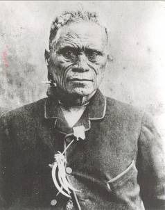
s7)    Other matters
          In achieving the purpose of this Act, all persons exercising functions and
          powers under it, in relation to managing the use, development, and protection
          of natural and physical resources, shall have particular regard to—
          a) Kaitiakitanga [(aa) The ethic of stewardship:]

          s8)    Treaty of Waitangi
          In achieving the purpose of this Act, all persons exercising functions and
          powers under it, in relation to managing the use, development, and protection
          of natural and physical resources, shall take into account the principles of the
          Treaty of Waitangi (Te Tiriti o Waitangi).

2.4       Historic Places Act 1993

          The Historic Places Act 1993 over rides all other planning legislation for
          archaeological sites.

          Any disturbance of archaeological sites, regardless of their listing or otherwise in
          the Proposed District Plan, is not permitted under Section 10 of the Historic
          Places Act 1993. Consent of the New Zealand Historic Places Trust is required
          to modify or disturb an archaeological site under Section 11 of the Historic
          Places Act. An authority is required for such activity whether or not the land on
          which an archaeological site may be present is designated, a resource or
          building consent has been granted, or the activity is permitted under the
          regional or District Plan1.

          Under the Historic Places Act 1993 (section 2) ‘archaeological site’ means any
          place in New Zealand that—
          (a)     Either—
          (i)     Was associated with human activity that occurred before 1900; or
          (ii)    Is the site of the wreck of any vessel where that wreck occurred before
                  1900; and
          (b)     Is or may be able through investigation by archaeological methods to
                  provide evidence relating to the history of New Zealand.

2.5        Hamilton City Proposed District Plan

          The Proposed District Plan has been prepared under the Resource Management
          Act 1991. The District Plan defines the way in which the city’s natural and
          physical resources will be managed to achieve the principles and purpose of the
          RMA. The plan provides a framework of resource management policy and
          implementation methods to manage the effects of the use, development, or
          protection of land associated with natural and physical resources.

          Objective 5.2.2 ‘Values of Recreation Land’ of the District Plan is “To maintain,
          enhance and where appropriate acquire recreation land with identified
          environmental, cultural, and heritage values”.

          Three different Recreation Zonings have been used to zone the riverside
          reserves included in this management plan. The Zonings are:
          • Recreation Environment
1
    Hamilton City Proposed District Plan (November 2001), Rule 2.5-2.

                                                                                            9
•   Recreation General
•   Recreation Major

2.5.1 Recreation Environment:
The majority of riverside reserves are zoned Recreation Environment. Within
this zone there is an emphasis on the protection of conservation values. The
zone provides for activities that are generally informal or passive, and includes
public access to the Waikato River and stream system. A large number of parks
contained in this zone are subject to an Environmental Protection Overlay,
which, in recognition of their fragile nature, provides for limited development
only.

Rule 4.8 of the proposed District Plan states the outcome for Recreation
Environment: “Activities and development within the Recreation Environment
Zone are undertaken in a manner that is compatible with the environmental
values of the zone and ensures any adverse effects on surrounding residential
development (in particular) are avoided, remedied, mitigated”.

2.5.2 Recreation General:
This zone provides for recreation land for informal and organised active
recreational use. The zone allows for a range of facilities/buildings, organised
team and individual sports as well as more informal recreational pursuits. Some
parts of parks zoned Recreational General may also serve an environmental
function.

2.5.3 Recreation Major:
The Pa on Hamilton Gardens is the only reserve with a Recreation Major zoning.
This zone provides for parks to serve the city wide and regional population. The
scale of development permitted on the parks in this zone is greater than in other
recreation zones.

2.5.4 Overlays:
In addition to the Recreation Environment zoning most of the riverside reserves
are also subject to the Environmental Protection Overlay that recognises the
fragile nature of these areas and provides for limited development only. The
overlay provides controls over earthworks, vegetation removal, stormwater
disposal, and buildings.

Most of these sites also have an Archaeological, Historic and Cultural Site
overlay. This overlay seeks to protect these types of features from activities that
could destroy, damage or modify them. Resource consent is required for
activities on these identified sites.

Section 7.2 ‘ Sites of Archaeological, Historic and Cultural Significance’ of the
District Plan identifies the following principal issues regarding sites of
archaeological, historical and cultural significance in Hamilton are:
    • Many archaeological, historic and cultural sites in Hamilton have been
        modified or destroyed as development has occurred, while others
        (especially in greenfield areas) may be under threat.
    • Many natural features which hold great historical, spiritual and cultural
        significance to local hapu have been destroyed by development.

                                                                                10
• Many historical sites in the city, where there is no above-ground
evidence, may have underground features and artefacts which could be
disturbed or damaged through earthworks.
• The relationship of maori with their culture and traditions with their
ancestral lands, water, waahi tapu and other taonga may be destroyed
or compromised through inappropriate development.
Objective 7.2.1 ‘Protection of Significant Sites’ is “To protect significant
European archaeological sites and tangata whenua historical and cultural sites
from damage, destruction and desecration”.
Policies:
a) Ensure that the protection and management of sites of archaeological,
historic and cultural significance reflects their significance and overall
heritage values.
b) Ensure that major development within new growth areas of the city are
examined for sites of archaeological, historic and cultural significance
before substantial changes take place.
c) Notify and consult with tangata whenua and the New Zealand Historic
Places Trust where development occurs on scheduled sites.
d) Ensure that activities or development, including planting, the removal of
vegetation where it effects the stability of the site and the removal,
addition, excavation or compaction of soil, rock or other materials do
not adversely effect the physical structure and integrity of scheduled
sites.
e) Ensure that activities, including subdivision and placement of structures,
avoid adverse effects on the cultural and spiritual values of any tangata
whenua historical and cultural site.
f) Encourage the permanent protection of sites where they are an
outstanding example of the particular type of site or are highly
significant to the community.
g) Encourage the recognition and on-site marking of scheduled sites where
features have been destroyed or damaged.
h) Encourage tangata whenua, Council, developers, property owners, other
agencies and the community to work towards the increased awareness
and recognition of scheduled sites.
The Proposed District Plan recognises Reserves Act Management Plans as an
‘other method’ to implement the objectives and policies of the District Plan
(Policy 7.2 proposed District Plan):
“Reserve Act Management Plans – will be developed for significant
archaeological, historic or cultural sites which are held as Council reserves. The
management plans could detail preservation works, landscape treatments,
signage and maintenance”.
2.6 Hamilton’s Strategic Plan 2002-12
Strategic Plans are documents prepared by the community, for the community.
Hamilton’s first Strategic Plan (Hamilton’s Strategic Plan 1997-2017) was
developed through an extensive process of community consultation and
participation. Hamilton’s Strategic Plan 2002-2012 is the second revision of the
plan. It contains the same key principles as the original and sets out the
11community’s vision for the future of Hamilton over the next 10 years, as well as
Council’s response through key projects and programmes.
Reserves Management Plans are one way of achieving some of the outcomes
identified in the Strategic Plan. The following goals are relevant to the
preparation of this management plan:
Goal 8: Hamilton has a positive internal and external image.
Goal 10: Kirikiriroa is established as a centre for traditional and modern arts
and culture
Goal 11: Cultural and built heritage is widely appreciated and protected.
Goal 12: A diverse range of learning and training opportunities is available to
meet the needs of the community and business at all levels.
Goal 13: Local neighbourhoods address the needs of their residents – socially,
physically and emotionally.
Goal 14: All people are enabled and encouraged to participate in the
development of the city.
Goal 16: A full range of land, facilities, and services is available to meet the
community’s recreation and leisure needs.
The principles of the Strategic Plan also reflect Agenda 21, which is a global
plan for sustainable development in the 21st century. Agenda 21 recognises
that global issues need to be addressed at the local level, hence the expression
“think globally, act locally’. The preparation of Reserves Act (1977)
management plans is one method through which Agenda 21 principles can be
implemented at a local level.
2.7 Hamilton’s Recreation and Leisure Plan 2002-2012
The Recreation and Leisure Plan is Council’s Action Plan for Recreation and
Leisure. Developed by a community advisory panel, the plan identifies issues
and options for recreation and leisure in Hamilton, and includes strategies to
meet the needs of Hamilton’s residents.
The following objectives are relevant to the preparation of this management
plan:
Objective 1.2: To work in partnership with other organisations to enhance
existing Council recreation and leisure facilities with relevant and
complementary amenities.
Outcome 1.2(d): Existing parks and walkways are enhanced in ways that better
meet the needs of the community.
Objective 1.3: To work in partnership with other organisations to create new
recreation and leisure opportunities to meet the current and future needs of
Hamilton’s community and visitors.
Outcome 1.3(e): Sufficient open spaces to satisfy the recreation and leisure
needs of the people of Hamilton and its visitors are provided.
Outcome 1.3(f): Cycle/walkway linkages between Hamilton’s residential and
commercial nodes, open spaces and the river corridor are provided.
12Objective 2.1: To enable the people of Hamilton to participate in the recreation
and leisure planning process so they can achieve their recreation and leisure
goals.
Outcome 2.1(a): People in our community have participated in the
development of Council recreation and leisure opportunities.
Objective 3.1: To work in partnership with other organisations to keep the
people of Hamilton and visitors informed of and encouraged to use our
community’s recreation and leisure opportunities.
Outcome 3.1(b): Council’s recreation and leisure facilities are promoted and
well used.
3.1.5 Development and erection of informational signage that explains the
Maori cultural/historical significance of Council’s recreation and leisure
facilities.
2.8 Hamilton’s Walkway Strategy
Hamilton’s Walkway Strategy is being reviewed concurrently with the
preparation of this management plan. The walkway strategy was initially
established under the Hamilton City Comprehensive Development Plan 1974.
Its review is identified as an outcome of Hamilton’s Recreation and Leisure Plan
1998-2001.
Recently the Strategic Plan 1999-2019 and its Long Term Financial Strategy, the
Riverside Reserves Management Plan, the Gully Reserves Management Plan,
the Mangaonua Walkway Study, and Landscape Management Plans have
provided direction for further development of Hamilton’s walkway system.
The review of the walkway system strategy acknowledges the need for a single
comprehensive and integrated document for the maintenance and development
of existing and proposed walkways. The riverside reserves provide an excellent
walkway resource. The acknowledgement of traditional Maori landmarks on
these reserves will further enhance the walkway experience.
133.0 Objectives and Policies
3.1 Riverside Reserves Management Plan (1997) Objectives and
Policies:
The following Riverside Reserves Management Plan Objectives and policies
apply to the sites included in this management plan (the numbering of
objectives is consistent with the numbering used in the Riverside Reserves
Management Plan):
Natural Character and Historic Features:
Objective 2.2.1(a): “To preserve the natural character and amenity of the
riverside reserves”.
Objective 2.2.1(d): “To conserve all objects, trees and landforms of historic
significance on riverside reserves”.
Vegetation Management:
Objective 2.4.1(a): “To protect and enhance the riverbank by encouraging
shrub and tree planting, particularly native varieties”.
Tangata Whenua:
Objective 3.1.1: “To provide for Maori cultural, spiritual and social values and
practices”.
Policies:
(a) Where an unnamed reserve includes any part of an historic pa site, that
reserve will be named after that Pa. Both European and Te Reo Maori
names will be used in signage and in this management plan.
(b) Where practical, consideration will be given to extending riverside
reserve land to include pa and Urupa (burial sites) and sites with
important historical associations, to protect and conserve them.
(c) Where practical, the principal historic pa sites will be emphasised and
enhanced in a variety of ways, and in a manner which avoids any
modification or damage. Methods will include on sites interpretation,
such as carved interpretation of the history of the site with artistic
themes depicting local Maori traditions or recording the tangata whenua
associated with the site.
(d) Park development will be sensitive to wahi tapu and sites where there is
physical evidence of Urupa (burial sites). Koiwi (human remains) may be
retained on reserves. Where development of sites adjacent to riverside
reserves requires the relocation of koiwi, consideration may be given to
these being relocated onto the adjacent reserve and appropriately
memorialised.
(e) All significant decisions related to known pa and wahi tapu sites will be
made in consultation with representatives nominated by the appropriate
tangata whenua.
Promoting Safe Use
Objective 4.1.1(a) “To further promote awareness of Hamilton’s riverbank
parks”
14Riverwalks and Cycleways
Objective 4.3.1(a): “To achieve a continuous public walkway along the
riverbanks within the City boundary as part of the City’s walkway system”.
Natural Riverbank Areas
Objective 6.2.1(a): “To protect sensitive or unstable sections of the riverbanks
from inappropriate use or development, and to preserve sites of historic,
archaeological, biological or cultural significance”.
Riverside Recreation Areas
Objective 6.3.1: “To manage activities and development that will enhance
public use and enjoyment of the river parkway system without substantially
compromising the natural environment”.
3.2 Tikanga Maori - Objectives and Policies:
The objective and policies below have been prepared specifically for the sites
included in this management plan. The policies have been prepared to provide
further management specificity for the maintenance, management, and
development of these archaeologically and culturally significant sites:
Key Objective:
To protect ancient historic sites from degradation by conserving them for
future generations based upon Tikanga Maori (maori cultural concepts)
protocols.
Policies:
1.0 Picnic tables and toilets should not be positioned on Pa sites. Any such existing
facilities should be re-located to another part of the reserve.
Explanation: The fundamental principle behind this protocol is that many parts
of the Pa were tapu (sacred) to the Ngati Wairere people who lived there and
to their present day descendants. The bones of their ancestors, who were slain
in battles at the Pa, or simply died there of old age, are also buried in or
around the Pa.
2.0 The removal of exotic or introduced trees and plants, accompanied by the
planting of appropriate native species should be encouraged.
Explanation: Although in ancient times Ngati Wairere was a fierce hapu with
many noted warlords, they were also renowned for their horticultural abilities.
The people who lived at the riverside Pa/papakainga sustained themselves by
growing traditional crops in and around the village, collecting berries and fruits
from the native trees that grew along the river bank and snaring the birds that
came to feed on these berries. In this way, the native plants and trees that
grew in the area were an integral component of the environment and lives of
these Pa people.
It is therefore appropriate to commemorate these Pa sites by recreating the
environment, which was such an integral part of the Pa and its people.
15Nga Mana Toopu O Kirikiriroa will be given the opportunity to use the exotic
trees, which are currently on these sites. Those of sufficient dimensions might
be used for carving, others may be burned in specially prepared fires.
The ceremonial burning of smaller trees comes from the traditional ritual of Ahi
Ka (home fires) whereby a fire was lit and always maintained to demonstrate
the occupation of an area by a particular hapu and the status of that hapu as
Mana Whenua for that area.
3.0 Prior to any activity involving excavation, modification or disturbance of the
riverbanks in the vicinity of Pa sites Nga Mana Toopu O Kirikiriroa must be
consulted. Signage noting and explaining the prohibition (Rahui) on digging or
excavating these areas should be erected.
Explanation: It was common practice for ancient Maori to bury the remains of
their dead ancestors in naturally occurring, or man made caves in the banks of
the river. As discussed later in Section 6.6, many of the Koiwi exhumed from
the Urupa that were being destroyed during the early development of Hamilton
City were re-interred in caves in the river bank.
The result of excavating the river bank was clearly demonstrated when the
excavations for the foundations of the Fairfield bridge broke into and exposed
an ancient burial cave containing the preserved heads of two famous Ngati
Wairere Chiefs.
Any works must also comply with Rule 2.5 of the Proposed District Plan and
the Historic Places Act 1993.
4.0 To ensure the complete protection of all surviving features (ditches etc.) on
these sites. The protection of the sites will include the following elements:
a) The use of bicycles or motorcycles on any surviving earthworks should
be prohibited. This could be facilitated by fencing off the actual Pa site,
thereby making it difficult for people on bikes or motorbikes to access
the site.
b) All existing and future pathways and tracks should be diverted away
from the ditches and trenches of the Pa, to protect them from any
further physical damage.
c) All people undertaking maintenance work that uses machinery, such as
tractors or mowers, must ensure that no damage is done to the sites
from their activities or the wheels of their vehicles.
d) Parking of vehicles on the site should be prohibited, other than those
required for Council maintenance of the site.
5.0 All earthworks must be undertaken under the terms and conditions of protocols
developed by Nga Mana Toopu O Kirikiriroa (see Appendix 3). These terms
and conditions are to be undertaken in the event that any Taonga or Koiwi
(human remains) are unearthed during any earthworks at these sites.
Explanation: This protocol is designed to ensure that the correct statutory
processes are followed, particularly in the case where human remains are
uncovered. It also allows Maori to undertake the exhumation and re-interment
of any ancestral Koiwi with the appropriate ceremonies and rituals.
166.0 Sites where there are naturally occurring fresh springs should not be piped or
diverted. The spring itself should be maintained free of rubbish and pollution.
Easy access to the spring should be developed to allow local Maori to use the
spring water in traditional ceremonies and rituals. Where drinking fountains are
provided on reserves in the vicinity of pa sites, a water tap should also be
provided.
Explanation: This protocol is based upon the traditional belief of Maori in the
cleansing and spiritual powers of spring water.
7.0 A special area should be designated at each site for the ceremonial burying of
placenta (afterbirths) for Maori who have ancestral links to key ancestors
associated with the site. Non-Maori people should be prohibited from burying
afterbirths or the ashes of their deceased on the Pa sites.
Explanation: This protocol is not designed to be exclusive or racist. Rather it is
based on traditional Maori concepts of birth, life, death and the link between
the Mauri (life force) of all living things to that of the land.
Whilst the word Whenua is commonly taken to mean land, in reality it is the
Maori name for a placenta or afterbirth. In pre-European times, and even in
some instances today, it was Maori tradition to bury the afterbirth in a gourd
on the land to which the child's ancestors belonged. In this way the new child
was linked to its Turangawaewae (standing place) for eternity. This tradition is
the basis for this protocol.
In the same context, if other races and people who are not joined by
Whakapapa (lineage) to the ancestors of the Pa were to bury their children's
placenta on the actual Pa site, this would desecrate the Mauri of the site.
Similarly, as Maori did not cremate their dead, but rather held their preserved
remains as Taonga, the scattering of ashes of cremated remains over the actual
Pa site would also desecrate the Mauri of the site.
These burial sites should not be publicly identified. People wishing to use
them should be directed by Hamilton City Council to Nga Mana Toopu O
Kirikiriroa (NaMTOK). NaMTOK will assist people in the correct burial of their
whenua in the prescribed area.
8.0 All Council staff involved in the planting of native plants and trees at these sites
must observe a Rahui on site. This will involve a blessing of the area to be
planted by the Kaumatua of Nga Mana Toopu O Kirikiriroa before the planting
begins. The area to be planted may need to be fenced off before, during and
after the planting to protect the young plants and their root systems from
damage. The Rahui and fences will remain in place until the Council staff are
certain that the newly planted trees are firmly and permanently established.
Explanation: This protocol follows the traditional Maori horticultural practices
and is designed to protect newly planted areas until the new plants are firmly
established.
9.0 Sufficient rubbish bins should be installed at each site, appropriately positioned
away from the location of the actual Pa.
1710.0 Any erosion of the site particularly along the river margin should be reported to
Nga Mana Toopu O Kirikiriroa, and Council should install erosion control
measures that are compatible with the river environment and landscape.
Explanation: This protocol is intended to not only prevent destruction of the
actual Pa site by erosion of the river bank, but also to ensure that any such
erosion does not expose any burial caves in the river bank.
4.0 Arrival of Europeans at Kirikiriroa
4.1 Introduction
Maori from the Tainui canoe arrived in the area now known as Hamilton over
400 years ago. They called the area where they built a Pa between London
Street and Bryce Street ‘Kirikiriroa’, which means ‘long strip of cultivated land’.
Early settlers also called the area surrounding Kirikiriroa Pa, ‘Kirikiriroa’. This
settlement was renamed Hamilton in 1864.
Europeans arrived at Kirikiriroa approximately 170 years ago. This section looks
at the arrival of Europeans to area of Kirikiriroa, the Waikato Land Wars (1863-
1865), European settlement in Kirikiriroa and the subsequent development of
Hamilton City.
4.2 Kirikiriroa: Maori Settlement
From the early 1830’s Europeans slowly started to arrive in the Waikato. Local
Maori had been aware of Europeans and their tools and technology well before
they appeared in the Waikato. Missionaries had been living in the Bay of
Islands for some time before Waikato Maori met their first European man.
Around the 1830’s and 1840’s pioneer missionaries travelled south from early
settlements in the Bay of Islands and started to arrive in to the Waikato. During
this period a chapel and raupo dwelling were erected at Kirikiriroa Pa for use by
visiting clergy.
During the 1830’s traders sailed up river from the Waikato entrance (Port
Waikato) and or crossed the bar into Raglan Harbour to barter iron goods,
blankets and textiles for flax fibre and timber. The traders visited Kirikiriroa and
other Maori settlements in the Waikato.
In 1840 British sovereignty in New Zealand was proclaimed and the capital of
the new colony was established in Auckland. It would take several decades
however, before British law was effectively established in the Waikato region.
Maori continued to control intercultural contact with the growing a number of
Europeans interested in visiting the Waikato.
Some time after 1840 tourists began to visit Kirikiriroa. They included hunters
and others keen to see the progress of agriculture, European-style education,
and missionary endeavour in the Waikato. The missionaries taught Maoris
Eurpoean-style farming and methods of cultivation. Between 1845 and 1855
large areas of wheat were grown, groves of fruit trees yielded in abundance and
18potato patches produced good crops. At this time the river was busy as canoes
swept downstream toward the landing place near Waiuku, carrying potatoes,
kumara, corn, onions, pumpkins, wheat, peaches, apples, figs, pigs, goats,
chickens, and ducks from the Waikato.
As many as fifty canoes at a time were beached on the banks of Kirikiriroa as
produce was off-loaded and the proceeds spent on blankets, clothing, axes,
sugar, rum, and tobacco. Many villages accumulated their trading profits to
build flourmills on the river edge to make flour for themselves and the market.
”At this time there were still very few Europeans who had actually settled in the
Waikato. This was partly due to the difficulty in getting to the inland region,
regardless of its agricultural abundance. In the Waikato, apart from tracks
through the manuka swamp or bracken the only highways were the rivers and
the streams and the only craft available to use on these were the eminently
suitable native canoes. The population remained almost entirely Maori” (Norris,
1956, Pg 3).
Towards 1859 Auckland businessmen recognised the economic potential of the
Waikato but deplored its minimal pakeha involvement. The desire of these few
Aucklanders to gain control of the river lands was one of the important causes
of the subsequent Waikato War. In 1859 Governor Gore Brown wrote: “The
Europeans covet these lands and are determined to enter and possess them”.
”During the early 1850’s the move to create a Maori King began. Meetings
throughout the central North Island were held. There were several chiefs of
sufficient stature that were worthy of the position of Maori King, but selection
finally fell on Potatau Te Wherowhero, not only for his personal qualities, but
also out of respect for the Waikato riverlands that he represented. With the
declaration of Te Wherowhero as King at Ngaruawahia in 1858, the centre of
the King Movement was firmly settled in the Waikato. Te Wherowhero died in
1860, only two years after the declaration. He was succeeded by Tawhiao who,
at the age of 35, took on the task of King at a time of increasing tension
between Maori and Pakeha. Tawhiao hoped for peaceful co-existence but was
also determined that the administration of local affairs should remain in the
Maori hands. From the European viewpoint the King Movement was
unqualified rebellion and an added inducement for invading the Waikato” (The
King Movement – The Waikato River – It’s people, transport and trade).
4.3 The Waikato Land Wars (1863-1864)
”In July 1863 the Maori settlements were disrupted by the invasion of Waikato
by General Duncan Cameron and his Imperial Troops. The colonial government
had become increasingly alarmed by alleged threats of rebellion, opposition to
the sale of land, and the election of a Maori King. A separate system of Maori
government envisaged by the King Movement was not to be tolerated and the
rebellion was put down by military force. By December 1863 the troops had
reached Ngaruawahia, which had by then been abandoned by King Tawhiao
and his people”(Young, “Visions from the past Info. Kit – Kirikiriroa”, 1998).
The war continued on into 1864. One of the famous battles was that of Gate
Pa, Tauranga. It was here that the Commander of H.M.S Esk, Captain John
Fane Charles Hamilton was killed while leading the Naval Brigade in the attack
19on the Pa. Kirikiriroa was re-named ‘Hamilton’ in honour of Captain J F C
Hamilton upon the arrival of the 4th Waikato Regiment to Kirikiriroa in 1864.
The Battle of Orakau Pa, in which
the remnant Maori defenders
broke out of the south side of the
Pa and escaped across the river,
saw the end of the Waikato War.
“The New Zealand Settlement
Act, passed by the colonial
Government in 1863 under
Governor Grey’s leadership,
allowed the Crown to confiscate
1.2 million acres of land in the
Waikato. As compensation for
the expenses caused by the war,
the Government ordered the
confiscation of a large portion of
the Waikato Lands from the tribes
who had taken part in the
rebellion” (Stokes, “Visions from
the past Info. Kit – Kirikiriroa”,
Figure 1: Captain John F C Hamilton 1998).
The process of Raupatu (confiscation) was an attempt to destroy the economic
wealth and political strengths of Kingitanga. During this time the rich
agricultural resources were removed, control of the Waikato river system
overridden, and waahi tapu, burial sites, and sites of religious importance
desecrated. The effects of tapu associated with sites of religious importance
were removed under the supervision of King Tawhiao during the 1880’s. The
arbitrary confiscation of a huge area of land, practically the whole of the
Waikato, despatched some Waikato tribes from their tribal land.
4.4 Military settlement in Hamilton
Following the confiscation of Waikato land it was decided by the Government
that settlement of this land should be done by men who would be able to
defend it in case of future hostilities. For this purpose a special regiment of
militia was recruited from the Australian centres of Melbourne and Sydney.
A Gazette notice of 3 August 1863 set out the terms under which grants of land
were made to settlers: the militiaman had to be “not above 40 years of age,
have to be able to produce certificates of good character, good health, and
general fitness for service as required”.
“The terms of enlistment in the Waikato Regiment were as follows: free grants
of land were to be made on the scale of 400 acres for each field officer, 300
acres for each captain, 250 acres for the surgeon, 200 acres for each subaltern,
80 acres for sergeants, 60 acres for corporals, while each private was to be
allocated 50 acres. In addition, each man was to be allocated a town section
and 1,000 feet of timber to build a house. For the first year, until they received
their land, they were to receive rations. It was anticipated that by the end of
20the first year they would have cleared and planted enough ground to be able to
support themselves” (Morris, “Visions from the past Info. Kit – Kirikiriroa”,
1998).
The recruiting officer in Sydney was Lieutenant William Steele and the volunteer
group he enlisted became the 4th Waikato Regiment commanded by Lieutenant
Colonel William Moule. The 1st, 2nd, and 3rd battalions of the Waikato Regiment
were sited at Newcastle (Ngaruawahia), Alexandra (Pirongia), and Cambridge
(formerly known as Karapiro). The site chosen for the 4th battalion was the
deserted Maori village of Kirikiriroa, situated some 15 miles inside the
confiscation line.
The 4th regiment proceeded to Kirikiriroa on August 24, 1864 on the vessel
‘Rangiriri’ and a group of settlers landed at the abandoned Kirikiriroa Pa.
“Military reasons for occupying this location were the significance of occupying
an enemy village and the need to protect Newcastle (Ngaruawahia) from
possible reoccupation by Maori forces moving down the river. More
importantly, there was a convenient landing place for riverboats. The location
had several other advantages – the land was relatively flat, much of it had
been partially cleared or was covered only by scrub, it was easy to survey out
allotments (both urban and rural), and close at hand were large stands of
Kahikatea (easily worked for building purposes)” (Thomas, ‘An overview of
Hamilton’, Pg 109).
“Colonel William Moule, the commander of the 4th Regiment, decided that the
new town would be called Hamilton, in honour of Captain Hamilton of the
Naval Brigade, who died in action at Gate Pa” (Gibbons, 1977, Pg 35). The
towns of Hamilton East and West were quickly surveyed. The Government was
anxious to have the township of Hamilton surveyed off and lots allocated to the
soldiers so that the supply of free rations to the militia by the Government could
be stopped. The township of Hamilton East was first surveyed. Mr WA
Graham surveyed Hamilton in 1864. Within a year there were huts and stores
around the redoubts on both sides of the river. The river was the key to
transport, as it had been for the Maori.
A ferry service was established connecting the settlements on opposite banks of
the river. It operated between Ferrybank, just north of the present day rowing
club on the west side, to a point upstream on the east side at Memorial Park.
The Ferrybank was not only the crossing point from east to west but also the
loading and unloading area for early commerce. Eventually the railway arrived
in Frankton, which saw the formation of an over-land transport link with
Auckland.
By 1868 there were 250 people in the two Hamilton settlements on each side of
the river. “Clustered around the Ferrybank area and stretching up to the corner
of Grantham and Victoria Streets the first Central Business District for Hamilton
developed. Everything from general stores to chemists, and butchers were open
to the public. At its height of importance an estimated twenty premises and
houses were constructed in the vicinity. Most, however, had no secure tenure,
as they were temporary buildings on government land. By the mid-1870’s they
were being re-erected or replaced by new premises on Victoria or Collingwood
Streets” (Opus Consultants, ‘Central City Riverside Archaeological and Cultural
Assessment’, Pg 24).
21The population reached 666 in 1874 and 1243 in 1878. In 1877 the Borough
of Hamilton was formed through the combining of the East and West Hamilton
settlements. The Hamilton Township grew very slowly. New Zealand suffered
from a long depression in the 1880’s and the population of Hamilton did not
increase for 20 years. During this period the Central Business District moved
north of the Ferrybank area and developed around Victoria Street, turning its
back on the river.
The farming industry experienced considerable growth from the 1890s
onwards. Dairying expanded in the Waikato - small creameries grew into large
dairy factories, and today the Waikato area has one of the largest dairy
companies in the world (with its headquarters in Hamilton). Growth in
agriculture also led to growth in agricultural research at Ruakura. The
agricultural farm was originally used to train soldiers for farming after World
War I.
A real burst in the growth of Hamilton’s population happened during the post-
war years of the late 1940s and 1950s as the Borough extended its boundaries
over adjacent farmland. In 1951 Hamilton had a population of 30,000, only
594 of whom were Maori. In 1965 the University of Waikato took its first
enrolments. In 1966 Hamilton’s population stood at around 63,000. The baby
boom had hit Hamilton and by 1971 one third of Hamilton’s population was
under 14 years of age.
Today, Hamilton is New Zealand’s largest inland city with a population of
approximately 118,000 people from a diverse range of backgrounds and
cultures. Hamilton is the third fastest growing city, and urban area in the
country. Hamilton is a major service centre for the fertile agricultural region of
the Waikato. New Zealand’s dairy industry is centred in Hamilton, with a strong
technological-based research and development capability. Research facilities are
located in and around the city, including Landcare Research, AgResearch, and
Dairying Research Corporation.
Hamilton City has a rich history and contains a substantial number of sites of
archaeological, historic and cultural significance. Some of these are associated
with European settlement, however many of these sites are especially significant
to Waikato Iwi and local hapu.
225.0 Traditional Pa and Villages
5.1 Definition of Pa, Papakainga, Marae, and Urupa
To date, most of the literature about the riverside sites of ancient Maori
occupation dealt with in this management plan describes them as "Pa".
However some were Pa, but others were Papakainga, Marae, or Urupa. It is
therefore important to understand the differences between these types of sites.
A Pa was a fortified village where the Chiefs and warriors lived. Papakainga and
Marae were both unfortified villages but with different functions. Papakainga
were villages associated with food production and hence the people who
cultivated crops and collected food (bird hunters, berry collectors etc.) lived in
Papakainga. Marae were villages associated with tradition and religion and
hence those people involved with traditional ceremonies and formal welcoming
of visitors lived on Marae. An Urupa was a burial ground, which could be inside
or outside of a Pa, Papakainga or Marae.
The early European missionaries who came to New Zealand saw fortified Pa as
symbols of the ancient Maori pagan religion with its rituals and ceremonies.
Hence as part of their conversion to Christianity, the missionaries required
converted Maori to abandon their fortified "pagan" Pa and live in unfortified
"Christian" villages, which they established, known as Wharekura Pa. Over
time these unfortified Christian villages have evolved to be the modern day
Marae.
The ancient form of the fortified Pa, Papakainga and Marae are detailed as
follows:
5.1.1 Pa
In pre-European times, it was common for Maori tribes to send war parties to
invade other areas with the intent of "settling old scores", taking prisoners as
slaves, or taking control of an area and its resources for themselves. Whilst early
missionary accounts record two hundred people living permanently within large
fortified Pa, such as Kirikiriroa Pa, many more lived and worked outside the Pa
in Papakainga or Marae.
It was only when invading war parties came to the area that these people would
retreat inside the fortifications and thereby defend their position until the
invaders were defeated. They would then move out to the surrounding
countryside to continue their farming and other work.
In general fortified Pa was constructed by levelling an area of ground. Holes
were dug around the perimeter of the site and large, heavy, adzed wooden
poles or split logs would be set close together with manuka stakes leaving a
sufficient gap to allow spears to be thrust between them.
A ditch, approximately two metres deep and three metres wide, was dug in
front of the line of poles. The excavated earth was piled up around the wooden
poles to form a two metre high mound with part of each pole protruding out of
23You can also read