DISTRICT ENVIRONMENT PLAN FOR NORTH GOA DISTRICT - YEAR 2020
←
→
Page content transcription
If your browser does not render page correctly, please read the page content below
OA 360 NGT District Environment Plan for North Goa District

        DISTRICT ENVIRONMENT PLAN

                                                  FOR

                      NORTH GOA DISTRICT

                                                              YEAR 2020

                                                                          1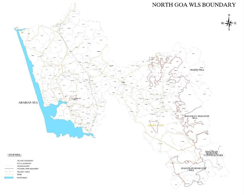
OA 360 NGT District Environment Plan for North Goa District

                                                    Table of contents
                 S.No          Particulars                              Page No
                               Preamble                                 04
                 1             Brief Profile of North Goa District      07
                 1.1           Location                                 08
                 1.2.          Geography                                10
                 1.3           Topography & Physiography                11
                 1.4           Rivers & Water bodies                    13
                 1.5           Coastal areas                            17
                 1.6           Forests                                  17
                 1.7           Environmentally Sensitive Areas          22
                 1.8           Soil                                     26
                 1.9.          Geology & Hydrogeology                   26
                 1.10          Mineral Deposits & Mining                28
                 1.11.         Industrial Development:                  30
                 1.12          Major industries                         30
                 1.13.         Climate                                  32
                 1.14.         Administrative Setup                     32
                 2.            Introduction                             34
                 3.            Approach Methodology                     34
                 4             Waste Management Plan                    35
                 4.1           Solid Waste Management                   36
                 4.2           Plastic Waste Management                 50
                 4.3           C&D Waste Management                     54
                 4.4           Bio – Medical Waste Management           59
                 4.5           Hazardous Waste Management.              63
                 4.6           E-Waste Management                       67
                 5.            Water Quality Management                 70
                 6.            Domestic Sewage Management Plan.         81
                 7.            Industrial Wastewater Management Plan    85
                 8.            Mining activity management plan          88
                 9.            Air Quality Management Plan.             93
                 10.           Noise Pollution Management Plan          96

                                                                                  2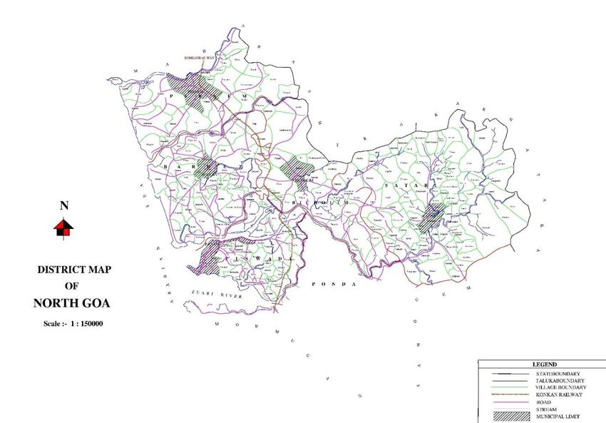
OA 360 NGT District Environment Plan for North Goa District

        Abbreviations
        NGT : National Green Tribunal
        DEP : District Environment Plan
        CPCB : Central Pollution Control Board
        C&D : Construction and Debris
        HTL : High Tide Line
        CRZ : Coastal Regulatory Zones
        LTL : Low Tide Line
        NCSCM : National Centre for Sustainable Coastal Management
        MoEF&CC : Ministry of Environment, Forest and Climate Change
        CZMP : Coastal Zone Management Plan
        GCZMA: Goa Coastal Zone Management Authority
        NDZ :No Development Zone
        GSWA :Goa State Wetland Authority
        GIS : Geographic information system
        MoWR : Ministry of Water Resources
        MSME : Micro, small & medium enterprises
        GIDC : Goa Industrial development corporation
        EIA : Environmental Impact Assessment
        CHWTSDF : Common hazardous waste treatment storage and disposal facility
        CPCB : Central Pollution control board
        SDO : Sub Divisional Officer
        GSUDA :Goa State Urban Development Agency
        DIDC :District industrial Development Corporation
        GWMC : Goa Waste Management Corporation
        WRD: Water resource department
        GSPCB : Goa state pollution control board
        SWM : solid waste management rules
        MC : Municipal Councils
        V.P : Village Panchayats
        SFR :State of forest report

                                                                                   3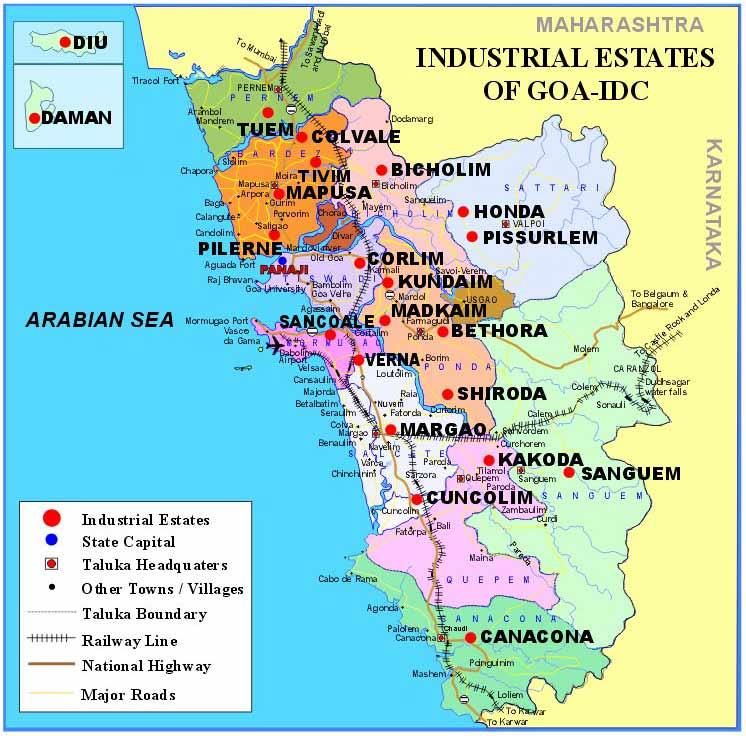
OA 360 NGT District Environment Plan for North Goa District

       PREAMBLE
        Hon’ble National Green Tribunal in O.A. No. 710/2017 dated 15.07.2019 further in O.A. No.
        360 /2018, (M.A. No. 823/2018) (SLP (Civil) No. 2959/2014), dated 26/09/2019 ordered to
        form the District Committee ( as a part of District Planning Committee under Article 243 ZD) for
        the preparation of District Environment plan as a Constitutional provisions under Articles 243 G,
        243 W, 243 ZD read with Schedules 11 and 12 and Rule 15 of the Solid Waste Management Rules,
        2016.

        In the above said order, it is stated that among others
        “Chief Secretaries may personally monitor compliance of environmental norms (including
        BMW Rules) with the District Magistrate once every month. The District Magistrates may
        conduct such monitoring twice every month.

        “We find it necessary to add that in view of Constitutional provisions under Articles 243 G,
        243 W, 243 ZD read with Schedules 11 and 12 and Rule 15 of the Solid Waste Management
        Rules, 2016, it is necessary to have a District Environment Plan to be operated by a District
        Committee (as a part of District Planning Committee under Article 243 ZD) with
        representatives from Panchayats, Local Bodies, Regional Officers, State PCB and a suitable
        officer representing the administration, which may in turn be chaired and monitored by the
        District Magistrate. Such District Environment Plans and Constitution of District Committee
        may be placed on the website of Districts concerned. The monthly report of monitoring by the
        District Magistrate may be furnished to the Chief Secretary and may be placed on the website
        of the District and kept on such websites for a period of one year. This may be made
        operative from 1.08.2019. Compliance of this direction may also be seen by the Chief
        Secretaries of the States/UTs. This may not only comply with mandate of law but provide an
        institutional mechanism for effective monitoring of environment norms.”

        In view of these directions, District collector of North Goa vide letter NGT/OA NO.710-713 of
        2017 /151 dated 11.11.2019 formed District Committee with representatives from Village
        Panchayats, Municipal Council and City Corporation , Regional Officers, Goa State Pollution
        Control Board, Dept of Environment and an officer representing the administration for
        preparing District Environmental plan. This District Committee chaired and monitored by the
        North Goa District Collectorate.

        The District Committee for North Goa District has been formed comprising following
        members.

                                                                                                            4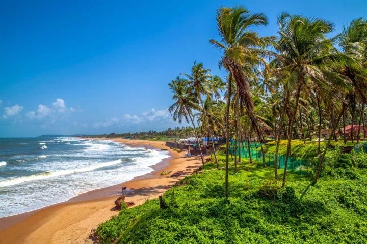
OA 360 NGT District Environment Plan for North Goa District
Table 1. District Committee- North Goa
Sr.No Name Designation
1 District Collector – North Goa District Chairman
2. OSD to the Department of Environment Convener
3. GM, Goa Waste management corporation Member
4 Deputy Director (North) Directorate of Panchayats Member
5 Add. Chief Engineer (I&P) Water resource department Member
6 Dy Director (Public Health) Directorate of Health services Member
7 Dy. Director (industries), DITC Member
8 Dy. Director (I) Directorate of Mines & Geology Member
9 DYSP, Traffic (North Goa) Member
10 Dy. Conservator of Forest (North) Dept. of Forest Member
11 Dy. Commissioner, Corporation of the City of Panaji Member
12 GM, Sewerage & Infrastructural Development Corp. of Goa Member
Ltd.
13 Chief Officer, Mapusa Municipal Council Member
14 Chief Officer, Bicholim Municipal Council Member
15 Chief Officer, Pernem Municipal Council Member
16 Chief Officer, Sankhali Municipal Council Member
17 Chief Officer, Valpoi Municipal Council Member
18 Jr. Environment Engineer GSPCB Member
A meeting of the District Committee to formulate the District Environment Plan for North
Goa District was held on 11/ 12/2019.
This DEP has been prepared in line with the model District Environment Plan (DEP) of CPCB
and covers following thematic areas.
1. Waste Management Plan
Solid Waste Management
Plastic Waste Management
C&D Waste Management
Biomedical Waste Management
Hazardous Waste Management
E-Waste Waste Management
2. Water Quality Management Plan
5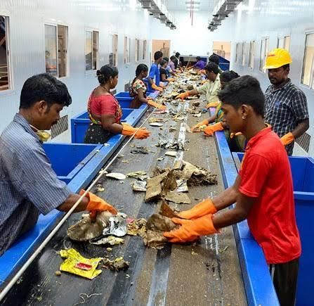
OA 360 NGT District Environment Plan for North Goa District

        3. Domestic Sewage Management Plan
        4. Industrial Wastewater Management Plan
        5. Air Quality Management Plan
        6. Mining Activity Management plan
        7.Noise Pollution Management Plan

                                                              6
OA 360 NGT District Environment Plan for North Goa District

        1. BRIEF PROFILE OF NORTH GOA DISTRICT.
        Goa, a tiny emerald land on the West coast of India is the smallest state of the India. “The
        Pearl of the East”, Goa with its long beaches along the Arabian Sea is a principal tourist
        destination and is known for its Gothic churches, crumbling forts, palm-fringed beaches,
        coconut groves, ferry rides, bubbly folk and music. Goa is a popular tourist choice not only in
        India, but also across the world.
        Goa with an area of 3,702 sq. km is situated between Karnataka and Maharashtra. It is
        bounded in the North by the Tiracol River (which separates it from Maharashtra) in the East
        and South by Karnataka State and West by the Arabian Sea.

        It is divided into two districts viz. North Goa District and the South Goa District. North Goa
        District is the administrative hub of the Goa state, with the presence of the State Secretariat
        and Head offices of all Departments of Goa. Panaji, the capital city of state of Goa, is a small
        picturesque town on the left bank of the river Mandovi. It is also the headquarter of the
        North Goa District.

                                    Source : from http://www.northgoa.gov.in/
                                            Figure 1. North Goa District Map
                                                                                                           7
OA 360 NGT District Environment Plan for North Goa District

        The North district is divided into four subdivisions – Panaji, Mapusa, Bicholim, and Ponda;
        comprising six Talukas – Tiswadi (Panaji), Bardez (Mapusa), Pernem, Bicholim, Sattari (Valpoi)
        and Ponda. However, for administrative convenience, Ponda has been shifted to the South
        District of Goa. Ponda Taluka is inserted in South Goa District as per Notification No.
        37/2/2014-RD published in the Extraordinary Official Gazette dated 23rd January, 2015
        Series I No.43.

        1.1 . Location
        The North Goa District has an area of 1736 Sq. Km. Its geographical position is marked by 15 o
        48’ 00” N to 14o 53’ 54” N latitudes and 73o E to 75o E longitudes. North Goa shares its North
        and East boundaries with Maharashtra state and Karnataka state, respectively. Similarly, it
        shares its southern boundary with the South Goa District. Map showing talukas of North Goa
        district is presented as figure 2.

                                       Figure 2. North Goa District Map
                                                                                                         8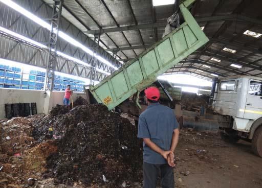
OA 360 NGT District Environment Plan for North Goa District

        1.2 . Geography

        North Goa being a part of the West Coast of India has many physical features that are
        common to neighboring regions of Maharashtra and Karnataka States. But the feature that
        lands the landscape and scenery of Goa a distinctive charm of its own, are mountains of the
        Sayhadris in the East. Further, the District comprises of middle level plateaus in the center
        with their detached elements abutting into the sea, the low-lying river basins and the coastal
        plains. Geographical area of North Goa district is 1736 sq.km. Landuse map of North Goa
        district is presented as figure 3.

                                       Source : North Goa irrigation plan
                                      Figure 3. North Goa District land use map
                                                                                                         9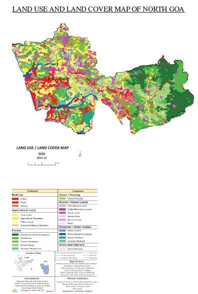
OA 360 NGT District Environment Plan for North Goa District

        1.3 . Topography & Physiography

        The topography of Goa state, as such is undulating slope varying from plain (slope  35%) along the eastern boundary of
        the state. Various terrain characteristics or slope types are found more or less evenly
        distributed throughout the district. Topographic map showing slope of North Goa is depicted
        as figure 4.

        North Goa district, which belongs to the “Central Midland region” characterized by
        moderately elevated but undulating terrain having roughly NW – SE trend; separated again
        by undulating tracts of deeply weathered etch plains.

        North Goa district comprises of coastal plain on the west, lateritic plateaus at the central
        portion and western ghats along the eastern most part. The river basins and the coastal
        alluvial flats are the lowlands of North Goa.

        1.3.1 Physiography

        Physio graphically, North Goa district can be broadly divided onto four distinct morphological
        units from west to east namely,

        •        Coastal plain with marine landforms on the west,
        •        Vast stretch of plains adjoining the coastal plain,
        •        Low dissected denudational hills & tablelands towards the east, and
        •        Deeply dissected high Western Ghats denudational hills along the eastern most part
                 of the district.

        As per. (Wagle B. G 2004) the entire Goa can be broadly classified into Coastal tract, sub-ghat
        region and the high ranges of the Western Ghats. Coastal tract are low lands, plateau land
        and mountainous region i.e Sahyadris range.

        Coastal plain
        The western and southwestern parts of Goa constitute the coastal plains. Central land
        masses of this portion of Goa appear to have emerged out of the sea, as can be observed at
        Panaji, and Calangute in North Goa district. The coastline of North Goa is a scenic alteration
        of bays and headlands significantly broken by large estuaries of Mandovi and interspersed
        with minor estuaries. The bays of Baga and Calangute are extensive curved stretches which
        with their near white sands and palm fringes form one of the main tourist attractions of Goa.
        The formation of the two major river systems viz. Mandovi and Zuari has resulted from faults
        during the uplift of landmasses. The coastal plains include beaches, mudflats, swamps,
        saltpans and fluvio-littoral. plains.

                                                                                                          10
OA 360 NGT District Environment Plan for North Goa District
Prominent beaches of North Goa District are Calangute and Colva. Panaji forms a part of a
lagoon where the River Mandovi joins the Sea. Situated in the creeks and riversides are
marshy lands locally called Khazan or Contour lands.
Of the many rivers that drain the land of the North Goa District, Tiracol, Chapora and
Mandovi are the most important because of the extent of their drainage areas and the
human attraction they hold.
Source : North Goa irrigation plan
Figure 4. Topographic map / slope of North Goa district
11OA 360 NGT District Environment Plan for North Goa District
The Plateaus
The central portion of North Goa consists by and large, of plateaus at varying levels. The
plateaus have typical landforms that are quite characteristic of Goan scenery, the tops are
fairly level, but are in places deeply notched by gullies; along the coastline the lateritic
plateaus end in headlands (the Aguada). The river basins and the coastal alluvial flats, quite
in contrast to the lateritic plateaus and abundant in their usefulness, are the alluvial lowlands
of North Goa. These are the in-filled stretches of the rivers which have deposited the eroded
material from the Sahyadrian elevations along their banks, on losing their gradient when
they emerge from the highlands to meet the sea. The major riverine plains in North Goa are
those of Mandovi and Chapora in the North are smaller basins
The Sahyadri of Goa
The portion of the Sahyadri lying in Goa has an area about 300 sq. kilometers and an average
elevation of 800 metres. The Western Ghats, a continuous range of Sahyadri hills, form the
commencement of the high hill ranges in eastern Goa. These ranges occupy about 33% of
the total area of Goa. The altitudes of the principal hills range from 1022 m MSL (Darringa) to
251 m near Cabo de Rama. The foot slopes of this range extend to Sattari . The scarp face is
furrowed by ungraded streams many of which, in the steep falls, have waterfalls. Of the
isolated peaks with which the ranges of mountains are studded, the most conspicuous are:
Sonsogad (3827 feet above MSL); Catlanchimauli (2633 feet); Vaguerim (3500 feet) and
Morlemgad (3400 feet), all in Sattari taluka.
1.4. Rivers & Water bodies
1.4.1 Rivers
Principal perennial rivers draining through the North Goa district are, Terekhol, Chapora,
Mandovi and non – perennial (seasonal) river Baga. The river basin of all these westerly
flowing rivers originate from Western Ghats and drain in the Arabian Sea in the west under
estuarine environment.
The rivers in Goa are unique in being both tidal and rain fed, and therefore, perennial, except
River Baga, which is found to be partly perennial. The surface water system of Goa is
intimately linked up to their eco-development since they provide irrigational facilities to
agriculture, produces biotic and mineral resources and transport. Many of the rivers are tidal
prone up to distance of 20 to 40 km .
As per Water resource department there are around 12 major and minor rivers flow through
North Goa district admeasuring length of around 262 km. The rivers are Tiracol, Harmal ,
Mandrem, Chapora, Baga, Mandovi, Velus, Muaxi, Nanora, Ragad, Valavanti and Bicholim.
Map of rivers, water bodies and drainage pattern of North Goa district is shown as figure 5.
12OA 360 NGT District Environment Plan for North Goa District
1.4.2. Water bodies
Water bodies or lakes constitute a scenic feature in Goa, though most of them have a limited
and local use for irrigation. Most of them owe their origins to the bunds across stream
valleys, large and small, and on plateau margins and in alluvial flats. The major lakes of North
Goa are Mayem, Chimbel, Carambolim & Calapur these are discussed in brief in following
paragraphs.
Arvalem Waterfall: The waterfall is situated in Sanquelim. Leaving the temple of
Rudreshwar, one can descend the staircase to look at a majestic waterfall shedding its
exuberant silvery showers. The beautiful fall, with a head of about 70ft., forms a sizeable lake
at the bottom, the fall is best seen when in full flux, just after the copious monsoon.
Mayem Lake: A calm spread of water with geese and pedal boats in the midst of green hills
where one can commune with nature is an exciting experience. As you drive to the lake, the
picturesque countryside, with lovely villages and smiling folk on the way, offers a spectacular
sight.
Carambolim Lake: Just to the eastern side of Old Goa is the picture-perfect Carambolim
Lake. Adding to the charm of the quiet village of Carambolim is the scenic reservoir fringed
by lush greenery. Migratory birds seek this verdant landscape every year to frolic in the
natural splendor till the end of the season. The cacophony of 80 different varieties of birds is
unbelievable, tending to their young in the mixed heronries on the aquatic vegetation.
13OA 360 NGT District Environment Plan for North Goa District
Figure. 5 – Map showing water bodies and rivers of North Goa district.
1.4.3 Drainage:
The rivers in Goa have their origin in the Sahyadri ranges and flow westward into the Arabian
Sea, 60 km away. The drainage pattern in Goa is dendritic to sub-parallel. Rivers Mandovi
and Zuari, which are the two main rivers, with their tributaries draining 69% of its geographic
area. Most of these rivers are subjected to tidal variations and salinity upto a distance of 20-
40 km upstream from their respective mouth regions.
River Mandovi originates in Karnataka and meets the Arabian Sea near Panaji as an estuary.
Near the coast, River Mandovi shows braided pattern with several islands of which Diwar is
the largest. River Mandovi consists of two main branches, River Madei and River Khandepar.
Other smaller tributaries of River Mandovi are rivers Cudnem, Valvat, Bicholim, Assonora and
Sinquerim.
Tiracol River Basin: River Tiracol originates in the Western Ghats in the Sawantwadi district
of Maharashtra and forms the northern boundary of Goa. The river meets the sea near
14OA 360 NGT District Environment Plan for North Goa District
Tiracol village after traversing a length of 26 km in Goa; River Chapora, also known as River
Colvale, arises from Sawantwadi and meets the sea near Chapora village after traversing a
length of 32 km in Goa. River Baga arises in the Bardez Taluka. The tidal effects are felt upto
Anjuna in the northern part and Parra in the southwestern part of the area.
Above discussed are the basins of major river of North Goa district. In general, the drainage
pattern of North Goa district is dendrite, wherein the smaller drainage line meets the larger
one at an acute angle
Primarily the underlying rocks govern the drainage system in the area. The major river Zuari
follows the major NW synclinal axis. The river valleys are ‘V’ shaped in the western high hill
ranges, but broadens in central midlands and become ‘U’ shaped in the low lands and coastal
plains. Cumbharjua Canal is an important feature of natural drainage of Goa and it links the 2
main rivers of Goa; River Mandovi and River Zuari.
Source : North Goa irrigation plan
Figure 6. Drainage map of North Goa district
15OA 360 NGT District Environment Plan for North Goa District
1.5. Coastal areas
Goa is famous for its beautiful sandy beaches and several types of costal stretches. Goa
state is located on the west coast of India has a coastline over 105 km and inland waterways
up to 50 km. Of this around 00 km in North Goa district. The coast is full of creeks and
estuaries formed by rivers. Many of the rivers in North Goa are tidal prone up to 20 to 40
kms.
The coastal zone, comprising of ecologically sensitive areas and other geomorphological
features, plays a vital role in maintaining the integrity of the coast. The coastal and inshore
waters are very rich in fishery resources specially Mackerels and Sardines.
In order to regulate the development along the coastline, CRZ regulation is imposed to
protect its ecology and legacy. Coastal stretches are sensitive to development projects, CRZ
rules have been made under the Environment (Protection) Act, 1986 to safeguard these
coastal areas in year 2011. These areas are referred to as Coastal Regulatory Zones (CRZ).
CRZ is defined as: “the coastal stretches of seas, bays, estuaries creeks, rivers and backwaters
which are influenced by tidal action (in the landward side) up to 500 m from the High Tide
Line (HTL) and land between the Low Tide Line (LTL) and the HTL
It has been a consistent stand of the State Government that in view of Goa’s unique geo-
environmental situation, the CRZ Regulation should be made applicable up to 500 m from
the high tide line from the Sea at its highest tide, and not all along the tidal stretches of the
river as it is being sought to be interpreted. Coastal zone management plan of Goa is
restricted to the 500 m from the high tide line and 100 m or width of the river creek on
either bank. It had been observed that about 80% of Goa’s population is in the 5 coastal
talukas with river and creeks, which are partly tidal where it is mandatory to have 100 m
setbacks.
The draft coastal zone management plan for Goa state prepared by National Centre for
Sustainable Coastal Management (NCSCM) Chennai, MoEF&CC, is under finalization. Draft
CZMP map of North Goa district is given as figure
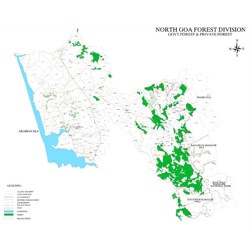
1.6. Forests
As per SFR published by the Forest, Survey of India, forest cover of the Goa state is around
2219 sq.km. i.e around 59.9% of the area comes under forest cover. The estimated tree
cover in the state is 334 sq.km which is 9.02 % of the Geographical area.
16OA 360 NGT District Environment Plan for North Goa District
As per Department of Forest, Government of Goa recorded forest area as 1424.46 sq.km
(approx.) out of which 200 sq.km is private forest, thus the Government forest land is
1224.46 sq km (approx.) which amounts to 33.08% of the geographical area of Goa.
As per SFR the forest cover of North Goa district is around 354.48 sq.km which covers 20.3 %
of the geographical area of North Goa district
The tropical wet evergreen forests occur in strands in the deeper valleys of the Ghats. This is
a rich vegetation of evergreen type with a variety of species. Tall trees, dense canopy, sparse
middle layer, climbing creepers and dense humus matting are characteristics in occurrence.
The tropical moist deciduous forests occupy a large area of the Sahyadrian Goa. They include
important strands of teak which are estimated to occupy considerable forest area. Bamboo
and cane, pre-monsoonal leaf fall of the deciduous species is quite a striking feature. The
forest cover of North Goa district is given in table 2 and map showing forest cover is shown
in figure 7
Table 2 showing area under Forests in North Goa
S. No. Taluka Area (sq. km.)
1. Tiswadi 1.78
2. Bardez Nil
3. Pernem 13.43
4. Bicholim 8.08
5. Sattari 280.99
Total 304.33
Source: Department of Forests, Goa.& zoning atlas report
17OA 360 NGT District Environment Plan for North Goa District
Figure 7 Showing forest cover in North Goa district
1.6.1 Types of Forests & Vegetation
The forests of Goa are typical of the Western Ghats (Southern Maharashtra and Karnataka).
There is diversity in the forests due to the variation in altitude, aspect, soil characters, slope
etc. As per Champion and Seth (1968) Classification of Forest types of India, the forests of
Goa fall in the following types:-
i) Estuarine vegetation consisting of mangrove species along narrow muddy banks of
rivers :
18OA 360 NGT District Environment Plan for North Goa District
This type occurs in isolated small patches along the banks of Mandovi and Zuari rivers
and other salt water streams. Botanically this zone is characterized by peculiar root
formations (stilt roots of Rhizophora, pneumatophores in Avicennia, knee root in
Bruguiera etc). The mangroves are found in the division mainly at Panaji in North Goa
District. The above categories of vegetation occur from sea level to 100m.
ii) Strand vegetation along the coastal belts : Most of the coastal regions of Goa is
rocky with projecting ridges. The strand vegetation is limited to a few patches of
narrow strip bordering the Arabian Sea. The vegetation along the south bank of the
river Mandovi near Panaji belongs to this category. Tree species mainly found are
Pongamia pinnata, Thespesia populinea, Calophyllum inophyllum, Cerbera manghas
and Pandanus tectorius. Many herbaceous species such as Neanotis rheedei,
lphigenia indica, Begonia crenata, Habenaria grandifloriformis, Tricholepis
glaberrima, Trichidesma sp. are found along rocky creeks and projecting ridges facing
the coast.
iii) Plateau vegetation confined especially to the low altitude : A major portion of the
vegetation in Goa belongs to this category, which is further divided into four types
viz. (a) Open Scrub jungle, (b) Moist deciduous forests, (c)Secondary moist mixed
deciduous forests and (d)Sub-tropical hill forest.
Open scrub jungle :This type of vegetation occurs from Panaji to Cortalim and from
Bicholim to Sanquelim. Anacardium occidentale is found on an extensive scale. The
vegetation is mainly composed of dry deciduous elements such as Carissa congesta,
Hollarrhena pubescens, Lantana camara, Calycopteris floribunda, Woodfordia
fruticosa, Grewia abutilifolia, Vitex negundo and species of Calotropis, Ziziphus,
Cassia, Ixora, Acacia, Albizia, Terminalia and Crotalaria.
Moist mixed deciduous forests : This is the main forest type, found in Goa, covering
more than half of the forest areas. In North Goa Division, this type occurs around
Tudal. Ordofind, Butpal, Molem, Codal, Abiche Gol near Valpoi, and Anmod ghat.
Predominant species are Terminalia crenulata, T. belerica, T. paniculata,
Lagerstroemia parviflora, Adina cordifolia, Albizia lebbeck, A. procera, Mitragyna
parvifolia, Holoptelia integrifolia, Trewia nudiflora, Dillenia pentagyna, Semicarpus
anacardium, Mallotus philippensis and Stereospermum colais.
Secondary moist mixed deciduous forests :Trees found in this type are knotty and of
coppice origin. A few trees of primary origin are found scattered. Such type is found
mainly in areas of "Kumeri cultivation" and in other areas affected by biotic
interferences. The main species found are Terminalia crenulata, T. chebula, Adina
cordifolia, Alstonia scholaris, Lannea coromandelica, Bombax ceiba, Careya arborea
and Dillenia pentagyna.
19OA 360 NGT District Environment Plan for North Goa District
Sub-tropical Hill forests :These forests have formed due to "Kumeri cultivation" in
the past. Syzygium cuminii and Cinnamomum verum are of common occurrence.
Caryota urens is the most common palm in this type of forest. In the second storey,
Strobilanthes callosus, Elaeagnus conferta and Capparis sp. are found.
1.6.2 Reserved and Protected Forests:
In Goa the Reserved Forests covers an area of 253.32 sq. km under section 20 of IFA and
under section 4 of IFA it covers 709.90 sq. km. And unclassed forest is around 261.24 sq.km.
As per Department of Forest the wildlife sanctuaries and the national parks in Goa are 20%
of geographical area i.e 740.4 sq km.
These protected areas are provided with complete protection to the fauna & flora to
conserve the unique biodiversity of the State. There are two wildlife sanctuary in the North
Goa district. Dr. Salim Ali Bird Sanctuary and Madei Wildlife Sanctuary.
1.6.2.1 Wildlife Sanctuary:
Dr. Salim Ali Bird Sanctuary
Spreading over an area of 1.78 km2, Dr.Salim Ali Bird Sanctuary is located at the western end
of the Chorao island along river Mandovi near Panaji.
The entire area has mangrove vegetation of about 14 different species and is covered by a
network of water channels having tidal variations. It is a suitable habitat for planktons,
shrimps, prawns and small fishes. During winter, between November and January, migratory
birds flock in thousands to feed on the mud flats in the Sanctuary.
Madei Wildlife Sanctuary
Located in the Northern most part of the Goa. It spreads over an area of 208 sq.km and
derives its name from Madei river which flows across this Sanctuary. The three highest peaks
of Goa, Sonsogod (1027 m), Talvche Sada (812 m) and Vagheri (725 m) are located within this
Sanctuary.
The favorable climatic conditions of the sanctuary ensures the presence of several distinct
forest types including West Coast Tropical Evergreen Forest, Southern Moist Deciduous
Forest and Subtropical Hill Forest in this Sanctuary and supports rich diversity of flora and
fauna. The first photographic evidence of tiger in Goa is from this Sanctuary.
20OA 360 NGT District Environment Plan for North Goa District
Figure 8. Map showing location and boundary of wildlife sanctuary at North Goa district.
1.7 Environmentally Sensitive Areas
The environmentally sensitive areas comprises of the natural and cultural resources of the
district and include heritage sites, forests, national parks, biosphere reserves, wild-life
sanctuaries, lakes, wetlands, mangrove forests, coral reefs, areas with specialised skills, tribal
areas, areas of tourist interest, archaeological monuments etc. These environmental and
cultural elements need conservation and protection.
Ecological sensitive areas include areas with significant ecological features and ecosystems.
The conservation and sustainable use of biological diversity are of critical importance.
The environmentally sensitive areas in North Goa districts are endangered / are species
present in Wildlife Sanctuaries, Turtle Nesting Ground, Coral Reefs, Estuarine Crocodiles,
21OA 360 NGT District Environment Plan for North Goa District
Mangrove Areas , Khazan land, Wetlands.
Biodiversity areas
As per Department of Forest the endangered floral species found in the sanctuaries are
Ophuros Bomaiensis, Ceropeigia Fantastica, Oberonia Brachyhlic, Brachystehna Malvaneuse,
Rawalfra Seprentina, Nilgiranthus Barbatus, Phyllanthus Talbotu, Decaschishia Trilobta,
Gymnacanthera Fargunana, Hyhaene Dichotoma, Garcinia Talbotu, Crypocarya Lawsonii,
Eugenia Macrocephalla Tricalysis Sphaerocarpa.
And the faunal species are Tiger, Panther, Leopard Cat, Slender Loris, Gaur, Mouse Deer,
Pangolin, Giant Squirrel, Sloth Bear, Flying Squirrel, Jackel (Canis aureus), Jungle Cat (Fells
Chaus), Mongoose (Herpestes sp.), Civet, Golden Gacko (Calodaretly Loides Aureus), Flying
Lizard (Draco Dussumteri), Python (Phython Molurus, Indian Cobras (Naja spp.), King Cobra
(Ophiophagus Hannah), Russel's Viper (Vipera Ruselli), Checkered Keelback (Xenochrophis
Piscator), Rat Snake (Plyas Mucosus), Peafowl (Pavo Cristatus), Great Indian Hornbill (Buceros
Bicornis), Indian Pied Hornbill (Anthracoceros Malabaricus), Hill Myna (Gracula species), Frog
Mouth (Batrachostomes species), White Bellied Sea Eagle (Haliaetus Leucogaster), Vuhures
(Gyps Bengalensis), Bazas (Aviceda Leuphotes)
Turtle Nesting Grounds:
Goa has been a nesting site for the Olive Ridley Sea Turtles. The nesting is sporadic and occur
throughout the coast of Goa. Out of the 105 km coastline of Goa, only about 6 km is left
appropriately for the Olive Ridley to nest. Morjim in the North Goa is the major nesting sites.
Morjim beach stretches for about 2 km between Vagator and Hermal beaches in Pernem
taluka of North Goa district. The major concentration of the Olive Ridley nests occurs near
the mouth of the River Chapora in Temb Vaddo in an area of about 1 km. This is a unique
area having porous sand and bound by Ipomea and Spinifix sand dune vegetation.
Coral Reefs:
Coral reefs can be broadly defined as ridges of limestone, the upper surface of which lies
near the sea level and consist of calcium carbonate secreted by the corals. They are known
for exceptionally diverse fauna and flora, complex food web, and tropic organisms. The coral
species Porites Lutea, Favites sp. Turbinaria sp. and Astrangia sp. are found at St. George’s
Islands in North Goa District.
Estuarine Crocodiles:
Of the three Indian species of crocodiles, the State of Goa offers a habitat for Mugger or
Marsh Crocodile (Crocodylus palustris Lesson). The largest wild population of Mugger in the
State resides along the mangrove fringes of Mandovi-Cumbharjua-Zuari complex. Goa is one
22OA 360 NGT District Environment Plan for North Goa District
of the few states that support the last few wild pockets of the Marsh Crocodile.
Mangrove Areas:
Mangroves are very specialized forest ecosystems of tropical and subtropical regions
bordering the sheltered seacoasts and estuaries. These stabilize the shoreline and act as
barriers against encroachment by the Sea. Salt tolerant inter-tidal halophytic plants
dominate the mangrove forests.
Mangroves are confined mainly to the narrow intertidal mudflats along the banks of an
estuary. The fringing nature of mangroves could be attributed to the rising topography of the
coast. Occasionally large patches of mangroves can also be seen as in Chorao Island of
Mandovi. However, the major formations occur along the Mandovi- Zuari-Cumbharjua
estuarine complex, which constitute more than 75% of the total (20 km) mangrove cover in
Goa.
The Chorao Island in the river Mandovi is one of the best mangrove forests in Goa and
houses most of the species found in North Goa. Chorao mangroves in the State have been
conserved at Dr. Salim Ali Bird Sanctuary. Species of mangrove found in Goa are Rhizophora
mucronata, Rhizophora apiculata, Bruguiera gymnorrhiza, Bruguiera cylindrical, Ceriops
tagal, Kandelia candel (K.rheedi), Avicennia afficinalis, Avicennia marina, Avicennia alba,
Sonneratia alba, Sonneratia caseolaris, Aegiceras corniculatum, Excoecaria agallocha,
Acanthus illicifolius, Lumnitzera racemosa etc.
Khazan:
Khazan lands are eco-sensitive low-lying areas that are influenced by tidal action. These
include the embankments, sluice gates, mangrove cover, backwaters, creeks and the
drainage canals. The mangrove vegetation near the outer embankment acts as wave
breakers and reduces the erosive power of the tidal waves. Hence Khazan lands play a vital
role in protecting the agricultural lands and surrounding villages of Goa from tidal ingress by
use of the intricate system of bunds. The total khazan land of Goa is 33.41 sq km, of which
North Goa has 24.15 sq. km
Wetlands:
Wetlands are transitional areas between aquatic and terrestrial ecosystems where the water
table is usually at or near the surface of the soil or the land is covered with shallow water.
These include marshes, swamps, floodplains, bogs, peatlands, shallow ponds, littoral zones
of larger water bodies, tidal marshes, etc. The prominent wet land in North Goa district are
Carambolim and Chorao. The Carambolim Lake, a freshwater tank having an area of 0.7 sq.
km, close to Old Goa, sustains a large and varied population of resident and migratory birds
23OA 360 NGT District Environment Plan for North Goa District
throughout the year. It has been shown by way of the Asian Mid- winter Waterfowl Count, to
be the major winter destination of migratory Waterfowls in Peninsular India and one of the
most important in the sub-continent
At present Goa State Wetland Authority (GSWA) have initiated wetland identification under
Wetland (Conservation and Management) Rules 2017 with the help of CSIR National Institute
of Oceanography. 35 wetlands have been identified and brief document preparations of the
same is ongoing. Depending on brief document and ground truthing of other water bodies,
the final number of water bodies may change with due course. However, Space Applications
Centre Ahmedabad (2009), has submitted a report where in 550 wetlands were identified in
Goa using remote sensing and geographic information system (GIS) technique.
In view of above, Department of information technology, Government of Goa under e-
governance has envisage implementing a common state enterprise GIS platform which will
be accessible to all departments across the state. Department is in process of selection of
system integrator for development, implementation, and maintenance of GIS based, E-
governance portal of Goa.
Sand Dunes in Goa:
The coastal stretch of the state is covered by sandy beaches backed by sand dunes, which
are sensitive geomorphic features of vital economical and ecological importance. A sand
dune is a mount, hill or ridge of sand that lies behind the part of the beach affected by tides.
They are formed over many years when windblown sand is trapped by beach grass or other
stationary objects. In North Goa, major sand dunes are located in Candolim, Morjim and
Arambol . The coastal sand dunes present on the beaches of North Goa with their respective
lengths in kilometers are given in Table below .:-
Table 3 Details of Sand Dunes in North Goa
S. No. Name of the sandy coast showing Sand dunes Length in km District
1. Keri 1.32 North Goa
2. Harmal 4.32
3. Mandrem to Morjim 7.38
4. Vagator 0.85
5. Calangute to Sinquerim 5.75
6. Miramar to Caranzalem 4.15
Source: Department of Science, Technology and Environment, Goa.
24OA 360 NGT District Environment Plan for North Goa District
Sacred Groves:
Sacred groves, known locally as Devari, Devaran and Pann are standing tributes to the
wisdom and foresight of our ancestors. This community conserved areas have the
concentrations of species and genetic biodiversity where nature can continue in her
mysterious ways to enrich life linkages. These groves are protected and preserved by the
local people. In North Goa the Sattari and Pernem Talukas has the tradition of sacred groves
which represent, patches of dense forests that are guarded through a deep sense of
gratitude. Ajobachi Rai, Koperdyachi Rai, Ajobachi Tali, Nirankarachi Rai and Pirapeth are in
North Goa district.
1.8 Soil Types
Soil characteristics of the terrain are important aspects of the environment. They meet the
basic needs of all agricultural production. The varieties of soils that occur in Goa are derived
from three geological formations; Basalt / Metabasalt, Granite / Granite gneiss and
Quartzite.
Soils of the North Goa district can be classified into 3 types namely (i) Laterite soil (ii) Saline
soil and (iii) Alluvial soil:
(i) Lateritic soil is the major soil type in the district. It is highly porous & permeable, slightly
acidic with low pH values, low in organic matter, Calcium and Phosphorus.
(ii) Saline soil in the district occurs in the flood plains of Zuari and Mandovi rivers in Tiswadi,
Bardez and Ponda taluks. It also occurs in Pernem taluk. The soil is deep, poorly drained and
less permeable. It is saline, high in pH and contains humus and organic matter.
(iii) Alluvial soil occurs as very thin strip along the coastline towards western part of the
district. It is reddish brown to yellowish, coarse grained and confined to narrow valleys of
rivers. It is well drained, acidic with low pH and organic content.
1.9. Geology & Hydrogeology
North Goa district is dominantly covered by the formation of Goa Group belonging to
Dharwar Super Group of Archaean to Proterozoic age. Deccan Trap of Upper Cretaceous
occupies a narrow strip along the northeastern corner to Lower Eocene age. The Goa Group
comprises of metamorphic rocks of green schist facies, and is divided into Barcem,
Sanvordem, Bicholim and Vageri formation in the ascending order of superposition. The Goa
Group of rocks has been intruded by granite gneiss, feldspathic gneiss, hornblende gneiss
and porphyritic granite, followed by basic intrusive.
25OA 360 NGT District Environment Plan for North Goa District
During the Sub – Recent and Recent times, the rocks have been subjected to lateritisation of
varying thickness. Thus, laterite occurs extensively covering almost all the formations in
North Goa district. Coastal alluvium occurring along the coastal plains consists of fine to
coarse sands with intercalations of sandy loam, silt and clay.
The Goa group of rocks is disposed in a general NW – SE direction. The rock types indicate
three cycles of folding. The straight coastline suggests the major fault along the west coast.
Associated with this fault a number of weak planes have developed. Along these weak planes
Terekhol, Chapora, Mandovi and Zuari rivers flow to meet the Arabian Sea. Western Ghats,
which extends in NS to NNW – SSE direction represent a prominent fault zone. Even though
the rock types of Goa Group have suffered considerable faulting, all the faults are not
exposed on surface owing to the extensive cover of laterite.
Hydrogeology
Occurrence and movement of ground water depends upon the type of rock formation,
structure, topography, rainfall, recharge etc. Ground water in the North Goa district occurs in
rocks having primary porosity & permeability or in those having secondary porosity acquired
due to weathering, leaking, tectonics, solutions etc.
Ground water bearing formations in the district are laterite, alluvium, granite, granite gneiss,
metavolcanics and metasedimentaries.
Occurrence of ground water and aquifer characteristics of various formations are as follows:-
Laterites
Laterites are the important water bearing formations. Laterites are of two types, viz. insitu,
occurring in plateau areas or of detrital origin generally occupying valley portions. Besides
inherent porosity, the laterites are highly jointed and fractured, which control their water
bearing capacity.
The topographic settings of laterites control its ground water potential. The thickness of
laterites extends up to 30 m. Ground water occurs under water table condition in lateritic
formation. Promising ground water bearing areas are located near Malpen and Tuem in
Pernem taluk, Advalpal and Mayem in Bicholim Taluka.
Alluvium
Alluvium constitutes good aquifers and is restricted to banks of rivers, Mandovi and Zuari.
Thickness of the coastal alluvium varies from 5 – 22 m, and comprise of fine to coarse sand
with intercalations of sandy loam, silt and clay.
Granite and Granite Gneiss
26OA 360 NGT District Environment Plan for North Goa District
Ground water occurs under unconfined, semi – confined and confined conditions in
weathered and fractured zones of granite and granite gneiss. Depth to water level in these
formations in open wells varies from 3.8 to 6.25 m bgl.
Metavolcanics
In unaltered state, metavolcanics is very poor in ground water. However, ground water is
found to occur in zones having secondary porosity and permeability imparted due to
weathering, joints and fractures. Ground water occurs both under water table and confined
conditions. Water bearing zones extend up to depth of 40 to 100 m.
Studies have indicated that bore holes drilled in metavolcanics with thick lateritic cover in
the plateau areas and close to lineaments have yields ranging from 2 to 5 lps.
Metasedimentaries
Metasedimentaries comprise shales, phyllites, schists, metagreywackes, argillites and
quartzites. The irrigation dug wells tapping weathered zones extending from 8.5 to 19.85 m
bgl in these rock units.
1.10. Mineral Deposits & Mining
The state of Goa is rich in mineral resources such as iron ore, ferro manganese, manganese,
bauxite, limestone, silica, clays etc. Iron and manganese mining are the major extractive
industries of North Goa.
In Goa, land away from the coast is rich in minerals and ores. The mining belt of North Goa
district is mostly Bicholim Taluka. The main mineral resources of economic importance
include iron ore, ferro manganese, manganese, bauxite, high magnesia, limestone, silica, and
clay.
Mining is an important activity in Goa. Mining has been a very important element in the
economic history of modern Goa. Most of the mines are in private hands. They were leased
out by the Portuguese authority during the pre-liberation days and inherited by the present
owners. Goa is a major iron ore exporting state and over 60% of country’s iron ore export is
from Goa.
However, the Mining has been stalled in Goa ever since the Honorable Supreme Court
cancelled 88 mining leases order in the state on February 7, 2018. This decision directly
impacted 60,000 households & 3 lakh livelihoods. The ban has stopped 15 million tons of
iron ore exports. It has disrupted an economy of Goa and affected allied industries, including
logistics suppliers, truck companies and barge owners as well as equipment suppliers also.
27OA 360 NGT District Environment Plan for North Goa District
The major concern of mining operations is open-cast mining, which severely affects the land
use pattern. The major environmental impacts of mining operations are degradation of land,
pollution of surface and groundwater resources, pollution of air, deforestation including loss
of flora and fauna, rehabilitation of affected population including tribal and impact on
historical monuments and religious places.
Quarries
As per Directorate of mines around 458 quarries were granted permissions in Goa in year
2015-16. However, these permits are not renewed after that.
Valid quarrying leases granted for extraction of minor minerals as on date are around 93 in
numbers and 40 mining leases are in North Goa district comprising an area of around
7,92,637 sq. m.
The location of active mines in North Goa district is shown in the mine map as figure.9.
Figure 9 Mine map of North Goa District
28OA 360 NGT District Environment Plan for North Goa District
1.11. Industrial Development:
The industrial landscape of Goa has undergone a tremendous face change since liberation in
1961. At the time of liberation, there were very few industries and the economy were
considered as a “money order” economy. From mining alone, the industrial activity of the
State has diversified into tourism, electronics, automobile accessories, pharmaceuticals, and
agro chemicals. Presently, the State harbors 23 industrial estates (goaidc website). Of this, 15
industrial estates are in North Goa district.
As per the 2015-16 data of Directorate of Planning, Statistics and Evaluation Goa, there are
around 521 factories registered under the Factories Act, 1948 in North Goa District out of
this around 259 are operational.
Around 3498 number of Micro, small & medium enterprises (MSME) registered with
Industries Department are in North Goa district. Large-scale industries are 63 in number. As
per GIDC (website) around 1580 industries are in IDC area in North Goa district.
According to 2015-16 data of Directorate of Planning, Statistics and Evaluation Goa, the
estimated average number of daily workers employed in registered factories of North Goa
district are around 36791. Approximately 28704 workers employed in MSME's of North Goa.
The average numbers of daily workers employed in large scale industries of North Goa
district are 9242 in numbers.
1.12. Major industries
Goa has a strong presence in mining, tourism and pharmaceuticals sectors. Mining (iron ore
and manganese), pharmaceuticals, iron and steel industries are present in North Goa.
Iron-Ore industry: The Iron Ore Industry is the main industry and forms the backbone of the
Goan economy. The iron ore deposits of Goa consist essentially of hematite and are
associated with the ferruginous quartzite and phyllites. The deposits containing an average
iron content of 63% by and large are concentrated in the northern and central parts of the
territory. The annual production of iron ore is around 15 million tons.
Pharmaceutical/ Drugs and Biotech Industries: The Pharmaceutical Industry has emerged as
a major component in the industrial development of Goa because of its ambience and
pollution free atmosphere that is conducive to the Pharma Industry.
Goa has also emerged as a manufacturing base for several leading companies in areas such
29OA 360 NGT District Environment Plan for North Goa District
as fertilizers, tyres and tubes, cement, electrical machinery, fishnet making machines,
automatic washing machines, printed circuit boards, pharmaceuticals and pharmaceutical
machinery. Cashew processing has also been a traditional industry in the state.
Tourism is the largest segment in the services sector. Goa is traditionally known as a tourist
paradise for its natural scenery, beautiful beaches and cultural diversity. Up to December
2018 around 8.01 million tourists have visited the state.
Source : GIDC
Figure 10. Industrial estates of Goa
30OA 360 NGT District Environment Plan for North Goa District
1.13. Climate
The territory, which is situated well within the tropics and flanked by the Arabian Sea to the
West and the Western Ghats (Sahyadri) rising to an average height of 1 km in the East, has
tropical-maritime and monsoon type of climate, with profound orographic influence.
Accordingly, the climate is moist throughout the year. Other features of the climate are the
regular and sufficient rainfall of 320 cm during the Southwest monsoon season, mainly from
June to September. The climate is generally pleasant. Discomfort may be felt in the absence
of wind particularly during pre-monsoon and post-monsoon months. Due to proximity of the
seas, the territory is generally humid, with a further rise in humidity during the monsoon
weather. Even in summer the relative humidity is above 60 percent. Temperature variations
through the seasons are also slight. May is the relatively warmest month when the mean
daily temperature is around 300 C and January the coolest with mean daily temperature at
slightly lower value of about 250C. Along the coast the maximum temperature recorded
rarely goes beyond 370 C.
1.14. Administrative Setup
In order to facilitate revenue administration, the entire geographical area of North Goa is
subdivided into Sub-divisions and Talukas. The North Goa District is divided into five talukas
and four sub-divisions. Talukas are further subdivided into revenue circles and circles into
revenue sazas. These sazas consist of compact revenue villages. At the grass root level saza
consists of a group of villages which is under charge of a Talathi. Circle inspector is in-charge
of the group of sazas of that revenue circle. Mamlatdar is the head of Taluka revenue office.
Dy. Collector & SDO is the head of the sub-division. District administration is headed by the
Collector. Collectorate is the district administrative office, where the policies of the
Government are translated into practice and the problems of local people are studied and
communicated to the State Government. Almost every citizen of a District comes into
contact with the District Administration, which deals with the public for issuing important
documents in land matters like licenses, certificates, permissions at District level, sub-division
level & at the level of Mamlatdar.
Subdivisions:
Panaji, Mapusa, Bicholim & Pernem
Talukas:
Bardez, Bicholim, Pernem, Sattari & Tiswadi (Ponda is now shifted to South Goa District for
administrative purpose.) Taluka Map of North Goa District is depicted below.
31OA 360 NGT District Environment Plan for North Goa District
Figure – 11- North Goa Taluka map (Indicative map)
32OA 360 NGT District Environment Plan for North Goa District
2. INTRODUCTION
As per Hon’ble NGT Order dated 26/09/2018 in OA 360/2018, an inventory have been generated
for 64 action areas of North Goa District in the format developed by CPCB “OA 360 NGT District
information plan.xlsx” .
3. APPROACH METHODOLOGY
The data used for preparing District Environment Plan is based on the data provided by all Village
Panchayats and Municipal Councils in the format given by CPCB, as well as data provided by
relevant departments viz. Directorate of Mines Geology, Water resource department (WRD), Goa
state pollution control board (GSPCB), Goa Waste Management Corporation (GWMC ),
Directorate of Transport – North Goa, Goa State Urban Development Agency (GSUDA), Ports
Department, North Goa District Collectorate, PWD and Town Planning Department, District
industrial Development Corporation (DIDC)
Documents referred for the preparation of DEP are Zoning atlas for siting of industries,
Environmental atlas of Goa, River action plan for polluted river, Ground Water Information
Booklet for North Goa by Ministry Of Water Resources, Central Ground Water Board, GoI, GIDC
website, EIA report for CHWTSDF by Aditya Environmental Services Pvt. Ltd. Inception Report
2018 prepared by iDeck for Solid Waste Management Policy for The State of Goa, DPR on
Common hazardous waste treatment facility prepared by SMS Envocare Ltd., Inception report on
Development of E-waste Management Plan for the State of Goa by The Just Environment
Charitable Trust (Toxic Links), Detailed Project Report (draft) for Sustainable management of C&D
waste in Goa by Sinteff, DPR for Development of a Biomedical Waste Management Plan for the
State of Goa by The Just Environment Charitable Trust (Toxic Links).
Village panchayats City corporations and Municipal councils have provided the required data
(DEP format prescribed by CPCB) regarding prevailing conditions of environment, solid waste
management etc. In duly filled format the population data is census data of year 2011 (as per
DEP). However, the action plan for each component of theme have been delineated considering
the population of year 2018 as well as projected population.
The detailed duly filled formats of City Corporation, all Municipal councils and Village Panchayats
are enclosed as Annexure and the outcome of the inventory is being discussed in subsequent
paragraphs.
33OA 360 NGT District Environment Plan for North Goa District
4. WASTE MANAGEMENT PLAN
4.1 Solid Waste Management Plan
Management of Solid waste is one of the most essential services for maintaining the quality
of life in urban or rural areas and for ensuring better standards of health and sanitation. Due
to rapid growth in population of India, this service falls short of the desired level as the
systems adopted are inefficient. Institutional weakness, shortage of human and financial
resources, improper choice of technology, inadequate coverage and lack of short- and long-
term planning are responsible for the inadequacy of services.
The Ministry of Environment, Forest & Climate Change, Govt. of India has notified SWM
Rules 2016. As per these rules, the role of local body has been specified in Rule 15 of SWM
2016, and as per Rule 16 of the said Rules Goa State Pollution Control Board shall enforce
these Rules through local bodies in respective jurisdiction.
In view of this the Government of Goa under the aegis of the Department of Science,
Technology and Environment has formed the Goa Waste Management Corporation (GWMC)
and entrusted it to look after the overall management of all types of wastes, collection of dry
non-biodegradable waste from Village Panchayats, Municipalities, State & Central
Government Institutions, Industrial Estates and other organizations in the State and its safe
disposal.
Additionally, as per the Solid Waste Management Rules 2016, the urban local authorities
themselves have responsibilities in managing solid waste in their jurisdictions. Additionally,
the Goa State Urban Development Agency is the nodal agency for implementation,
coordination and monitoring in respect of all 14 municipal corporation /councils in the state
of Goa and GSUDA is operating under the Administrative control of the Directorate of
Municipal Administration, Urban Development Department, Government of Goa.
In North Goa District there are 5 Municipal councils, 1 City Corporation and 102 village
panchayats. The quantity of waste generated by them is given in Table 2.
34OA 360 NGT District Environment Plan for North Goa District
Table 4: Waste generation by Talukas
Sr. Taluka Name Remarks Populati Total Waste
No on Generated
MT/ day
1 Pernem
Pernem Municipal council 5,021 1.2
Pernem block Village panchayats 73,658 3.5
2 Bardez
Mapusa Municipal council 39,989 25
Bardez Block Village panchayats 2,03,453 144.56
3 Tiswadi
Panaji City Corporation 40,017 50.0
Tiswadi block Village panchayats 1,34,585 18.9
4 Bicholim
Bicholim Municipal council 16,986 8.5
Sanquelim / Municipal council 13,043 7.4
Sankhali
Bicholim Village panchayat 77,307 8.34
block
5 Sattari
Valpoi Municipal council 8,532 5
Sattari block Village panchayats 55342 1.19
Source: PCA, North Goa district, Goa (as per census the total population of North Goa is 8,18,008 including
Ponda and excluding Ponda it is 6,52,178)
4.1. Solid waste management in North Goa District.
North Goa District generates around 274.49 MT, municipal solid waste per day which
includes waste from urban and rural area. The typical composition of solid waste is 53% wet
waste and 47 % dry waste. Average per capita waste generation is around 575 gpd. Around
59 % of waste generates due to household activities and 26% due to commercial activities,
mainly restaurants and hotels. The state attracts close to 8 million tourist footfalls in a year
added to its existing population of close to 1.5 million people.
Presently, GWMC is the nodal body for solid waste management in the state.
35OA 360 NGT District Environment Plan for North Goa District
Additionally, the Goa State Urban Development Agency is the nodal agency for
implementation, coordination and monitoring in respect of all 14 municipal corporation
/councils in the state of Goa and GSUDA is operating under the Administrative control of the
Directorate of Municipal Administration, Urban Development Department, Government of
Goa.
Abiding by the SWM Rules, 2016 issued by the Ministry of Environment and Forests,
Government of India, the solid waste is managed by the North Goa District efficiently.
The door to door waste collection system is efficient in the North Goa district. In urban areas,
like City Corporation of Panaji, other Municipal Council like Bicholim, Pernem, Valpoi and
Sanghali- it is achieved as 98 -100% . In rural areas the collection is achieved between 90 to
95%.
Segregated waste collection in North Goa Baling machine for plastic waste /dry
waste
Organic Waste Management Facilities integrated waste management facility at Saligao.
36You can also read