Kinsaley Draft Local Area Plan February 2019 - www.fingal.ie - Fingal County Council Online ...
←
→
Page content transcription
If your browser does not render page correctly, please read the page content below
Kinsaley
Draft Local Area Plan
February 2019

Fingal Development Plan 2017 - 2023   www.fingal.ie
Kinsaley
                      Draft Local Area Plan
                                          Chief Executive
                                                       Paul Reid

                                  Director of Services
                                        AnnMarie Farrelly

                                           Senior Planner
                                                  Colm McCoy

                           Senior Executive Planner
                                          Patricia Cadogan

iii
 i                           Kinsaley Local Area Plan : DRAFT
      February 2019
Contents                C
Contents                                                  3.8 Greater Dublin Drainage Project			                  8     5.5 Parking 								                                20

                                                          3.9 Flood Risk Management					                          8
1 Introduction		          					                       1
                                                          3.10 Road Network 						                                9     6 Green Infrastructure 						                       22
1.0 Statutory Context 						                          1
                                                          3.11 Pedestrian and Cycle Links 				                    9     6.1 Green Infrastructure Themes 				                22
1.1 Geographic Context				                     		     1
                                                          3.12 Recreational Amenity and Open Space 			            9     6.2 Archeology 							                              23
1.2 Purpose of the Local Area Plan				                1
                                                          3.13 Education and Community Facilities 			             9     6.3 Green Routes 							                            23
1.3 Why a Local Area Plan for Kinsaley? 			           2
                                                          3.14 Airport restrictions 						                        9     6.4 Green Infrastructure Objectives of the LAP 		   23
1.4 Pre-Draft Consultation 					                      2
                                                          3.15 Issues & Opportunities 					                       9
1.5 Environmental Assessments 				                    2
                                                                                                                        7 Parks, Open Space and Recreation 				             25

                                                          4 Vision and Development Strategy 				                  11    7.1 Introduction 							                            25
2 Legislative Context 						                          3
                                                          4.0 Introduction 							                                11    7.2 Hierarchy and Accessibility 					               25
2.0 Introduction 							                              3
                                                          4.1 Vision Statement						                              11    7.3 Quantity 							                                26
2.1 National Planning Framework 2018-2040			          3
                                                          4.2 Achieving the Vision 						                         11    7.4 Quality 								                                26
2.2 Regional Planning						                           3
                                                          4.3 Strategic Aims of the LAP					                      11    7.5 Sustainable urban Drainage Systems (SuDS) 		    26
2.3 Sustainable Residential Development Guidelines    3
                                                          4.4 Placemaking 							                                 11    7.6 Private Open Space 						                       26
2.4 S.28 Guidelines for Planning Authorities 			      3
                                                          4.5 Village Development Framework Plan 			              11    7.7 Existing Open Space 						                      26
2.5 Transport Strategy for the GDA 2016-2035			       3
                                                          4.6 Village Centre 							                              13    7.8 Proposed Open Space 					                       26
2.6 Cycleway and footpath Network Feasibility Study   4
                                                          4.7 Proposed New National School 				                   14    7.9 Kinsealy Lane Development Area 				             26
2.7 Fingal Development Plan 2017-2023 			             4
                                                          4.8 Active Open Space & Improved Recreational Facilities 14   7.10 Garden Centre Development Area 			             27

                                                          4.9 Additional Car Parking 					                        14    7.11 Teagasc Development Area 				                  27
3 Environmental Issues and Opportunities       		     6
                                                          4.10 Infill Development 						                          14    7.12 Malahide Road West Development Area 			        27
3.0 Introduction 							                              6
                                                          4.11 Amendment to LAP Boundary 				                     14    7.13 Malahide Road East Development Area 			        28
3.1 Landscape Character 		                  			       6
                                                                                                                        7.14 Kinsaley House Development Area 			            28
3.2 Historic Character 						                         6
                                                          5 Movement and Transport Strategy 				                  15    7.15 Riparian Corridor 						                       28
3.3 Existing Built Form 				                    		    6
                                                          5.0 Introduction 							                                15
3.4 Recent Construction						                         7
                                                          5.1 Existing Roads Network 					                        15    8 Creating Communities        				                  29
3.5 Proposed Road Objective 					                     8
                                                          5.2 Traffic Management and Development Access 		        16    8.0 Introduction 							                            29
3.6 Village Centre 						                             8
                                                          5.3 Public Transport Network 					                      18    8.1 Environmental Sustainability 				               29
3.7 Foul Drainage and Water Supply				                8
                                                          5.4 Walking and Cycling 						                          19    8.2 Community Infrastructure 					                  30

                 Kinsaley Local Area Plan   DRAFT                                 February 2019                                                                             iv
                                                                                                                                                                            ii
C Contents
8.3 Social Inclusion						                          31

8.4 Art & Culture 							                           31

8.5 Business and employment 					                   31

9 Water & Infrastructure Services 				              33

9.1 Introduction 							                            33

9.2 Foul Drainage & Water Supply 			                33

9.3 Surface Water Management 				                   33

9.4 Flood Risk Management 					                     35

9.5 Water Quality 							                           35

10 Village Development Framework Plan 			           37

10.0 Introduction 							                           37

10.1 Development Areas						                        37

10.2 General Guiding Principles					                37

10.3 Village Centre						                           38

10.4 Village Core Objectives 					                  39

10.1 Development Area 1 - Kinsealy Lane 			         41

10.2 Development Area 2 - Garden Centre 			         45

10.3 Development Area 3 - Teagasc 				              49

10.4 Development Area 4 - Malahide Road West 		     54

10.5 Development Area 5 - Malahide Road East 		     58

10.6 Development Area 6 - Kinsaley House 			        62

11 Phasing of Development & Application Requirements 66

11.1 Introduction 							                           66

11.2 Phasing of Development Areas 				              66

11.3 Checklist for Planning Applications 			        66

 v                                                                        Kinsaley Local Area Plan : DRAFT   iii
                                                          February 2019
Kinsaley Local Area Plan   DRAFT   February 2019   vi
                                                   iv
E Executive Summary
Purpose of the Local Area Plan                                       Policy Context                                                       Key Objectives of the LAP
A Local Area Plan (LAP) is a statutory document prepared             The policy context for Kinsaley is framed by national, regional,     The LAP outlines key objectives for the sustainable development
in accordance with Part II, Section 20 of the Planning and           and local policy objectives with the Fingal Development Plan         of the village in relation to:
Development Act 2000 (as amended). As a statutory document,          2017-2023 providing the most detailed objectives for Kinsaley
the Planning Authority and An Bord Pleanála must take account        and the local area. Kinsaley is defined in the Development Plan      •   new residential development
of the provisions of the LAP when considering an application         as a ‘rural village’ and as such is primarily zoned ‘RV’ – Rural     •   vehicular and pedestrian access
for planning permission for development. The provisions of a         Village. The village also contains ‘CI’ – Community Infrastructure   •   expanded village centre
draft LAP may also be taken into consideration.                      zoning (St. Nicholas of Myra Church and parish hall) and ‘LC’ –      •   natural heritage
                                                                     Local Centre zoning (St. Olave’s).                                   •   retail/ commercial
The purpose of an LAP is to examine a specific area in detail,                                                                            •   public open space and recreation
identifying and analysing the various issues affecting the           Existing Settlement                                                  •   community and social facilities
area and then setting principles and objectives for its future       Kinsaley is located approximately 1.5 kilometres west of             •   water and drainage
development.                                                         Portmarnock and 2.5 kilometres north of the suburban
                                                                     outskirts of Dublin City. Dublin Airport is 4.5 kilometres to the    Village Development Framework Plan (VDFP)
An LAP is valid for six years from the date of adoption by the       west. The village is situated around the junctions of Chapel         A Village Development Framework Plan (VDFP) is a guidance
Council. Its validity may be extended, in year 5 of the LAP for      Road and Malahide Road and Malahide Road and Baskin Lane.            and assessment tool designed to identify and protect the
a further 5 years, if deemed appropriate by a resolution of the      The lands surrounding Kinsaley are largely agricultural in           distinct physical and cultural characteristics of a place. The
Council.                                                             character, combined with the demesne lands of large country          VDFP is integrated into this LAP as Section 10 and sets out a
                                                                     houses, including Abbeville to the north-west and Emsworth           long term strategy for achieving the sustainable development
Public Consultation                                                  to the south. Kinsaley has a population of circa 340 persons         of the village, incorporating a diversity and mix of uses to create
At the end of May 2018, the Council published a Strategic Issues     according to the Fingal Development Plan 2017 – 2023.                a place where a balance is achieved between the natural and
Paper for Kinsaley entitled ‘Having Your Say’. The consultation                                                                           built environment as well as between the existing village and
period ran for 6 weeks, concluding on 13th July 2018. A total        The village core is centred on the parish church, the cottages on    new development. The VDFP sets out the principal guidance for
of 36 no. submissions were received during this time, each of        Chapel Road and the relatively recently developed lands at St.       the physical development of the village.
which has been considered in the making of this Draft LAP. A         Olave’s local centre with associated residential development.
public drop-in information session was held in Kinsaley on 13th      The village also incorporates the Garden Centre to the south of      This LAP has identified 6 no. development areas within the RV
June 2018 as a part of the public consultation activities and was    the LAP area as well as Kinsaley Business Park along Kinsealy        zoned lands of the village, the objectives for which are detailed
well attended. Submissions generally related to the following        Lane. The former Teagasc research facility located to the south      in the VDFP:
issues:                                                              of the village which, following consolidation of the research
                                                                     function into the Teagasc Centre in Blanchardstown, has              •   Kinsaley Lane Development Area – 2.6 ha
•    Village Character and the impact of additional development      ceased operation, now provides an opportunity for brownfield         •   Garden Centre Development Area – 1.3 ha
•    Traffic through and around Kinsaley                             development.                                                         •   Former Teagasc Development Area – 5.6 ha
•    Pedestrian and cyclist facilities in the locality                                                                                    •   Malahide Road West Development Area – 4 ha
•    Community Infrastructure including facilities for children      Vision Statement                                                     •   Malahide Road East Development Area – 0.6 ha
•    Retail facilities and other local amenities                     The vision statement for Kinsaley is as follows:                     •   Kinsaley House Development Area - 6.6 ha
•    School provision for new and existing residents
•    Protection of existing Trees and Vegetation and planting in      ‘Enhance and consolidate the village centre whilst ensuring the     All planning applications shall be based on the guidance
     new development                                                  sustainable expansion of Kinsaley at a level appropriate to and     outlined in the Kinsaley VDFP.
•    Visual Amenity and appearance of Kinsaley                        integrated with the existing village in which the housing, socio-
•    Infrastructure including for water and drainage services         economic and civic aspirations of the community are met while       Proposed Residential Densities and Potential Development
•    Availability of public transport in the village                  retaining its distinctive character and sense of identity and       Yield
•    Restrictions associated with the Dublin Airport noise zones      ensuring maximum environmental protection’.                         Kinsaley has the capacity to accommodate circa 483 additional
•    Village Name (Kinsealy or Kinsaley)                                                                                                  residential units in the identified Development Areas. This
•    The condition of the River Sluice and its role in the life of                                                                        figure, combined with the 82 no. units currently under
     Kinsaley                                                                                                                             construction/ undergoing marketing in the Kinsealy Woods
                                                                                                                                          development, will result in a net increase of 565 no. units

    vii                                                                                                                                                      Kinsaley Local Area Plan : DRAFT
                                                                                                February 2019
Executive Summary                                    E
above existing. This will increase the population of Kinsaley       centre and supporting physical upgrades to create a village            The provision of green routes around the village as well as the
from circa 340 to approximately 1,800. The overall density          where pedestrians feel comfortable, which operates/ functions          expansion and upgrade of a riparian amenity space along the
of development proposed is considered appropriate having            as a true village centre and provides a defined focal point for        Sluice River are key parts of the green infrastructure strategy.
regard to the Sustainable Residential Development in Urban          village life. The village centre will be characterised by:
Areas - Guidelines for Planning Authorities (May 2009) as well                                                                             Open Space and Recreation
as the need to respond to significant demand for new housing        •   A new civic space on the western side of the Malahide Road,        Under the Fingal Development Plan 2017-2023, Kinsaley
in the residential market. A range of densities are supported           bookended by a new mixed use retail building (preferably           contains a distinct area of Open Space (‘OS’) zoning adjacent to
across Kinsaley, from the lower density serviced sites to the           facilitating a convenience retailer) to define the space;          the Sluice River. Extending and improving this amenity area is
north of the LAP area where it interfaces with surrounding          •   Provision/ widening of footpaths throughout the village            an objective of the LAP and shall include additional public open
agricultural land, to higher densities around the village centre        centre area;                                                       space facilities and an extended area to the west. The provision
and within the Teagasc lands. An appropriate range of densities     •   Housing on both sides of the Malahide Road, oriented to            of active open space facilities associated with the proposed
for each identified Development Area are set out in the VDFP.           address the carriageway and to allow passive surveillance of       school, a new playground, as well as the provision of a network
                                                                        the street, the gardens/ green areas of which will contribute      of pedestrian and cycling routes around the village are also key
Road Network                                                            to the feeling of greenery in the Village Core.                    aspects of the approach to open space and recreation.
A number of improvements to the road and transport network          •   Variation in ground treatment to define the area, both on
in Kinsaley will need to be undertaken to improve traffic               the Malahide Road itself and the adjoining footpaths;              Teagasc Lands
movement around and through the village, as outlined in the                                                                                The Former Teagasc Research Centre is located to the south of
Movement and Transport section of the LAP. These include the        Retail /Commercial Development                                         the LAP area. Under the previous Development Plan, the lands
development of a dedicated pedestrian and cyclist network, an       The Council will promote and encourage the development of              were zoned Rural Business (RB), to provide for and facilitate
upgrade to the Baskin Lane junction, traffic calming measures,      retail and commercial services within a new village centre at          rural-related business (businesses which have a demonstrated
upgraded surface treatment through the centre of the village        a level appropriate to serve the residents of Kinsaley and its         need for a rural location). Following the discontinuation of the
and a new parking and drop-off area to serve the schools and        surrounding rural hinterland. This will ensure that Kinsaley can       research function of the site under Teagasc, the lands were
proposed sporting facilities.                                       serve as a key local service centre for the residents of the village   subsequently rezoned to Rural Village (RV) under the current
                                                                    and surrounding area.                                                  Development Plan (2017-2023). The development of this site
Education and Community                                                                                                                    (5.6 ha), along with the adjoining Kinsaley House site (6.6 ha),
The LAP proposes the provision of a new and expanded national       Employment opportunities close to Kinsaley                             represents a rare opportunity to not only provide key pieces of
school at the location of the temporary Malahide/ Portmarnock       The LAP provides for employment uses within the new village            community infrastructure, but also to help to define the future
national school to serve Kinsaley’s growing population. The LAP     centre, through the provision of additional retail and retail          character of the village.
also proposes new sports facilities, in the form of a mixed use     services space. The Kinsealy Business Park will also be supported
games area (MUGA) and full sized soccer pitch adjacent to the       in its continuing role of providing employment opportunities.          Phasing of Development
school. It is envisaged that these amenities will be available to   Indeed, the closure of the Teagasc Agricultural Research Centre        In the interests of ensuring that new development is well
the wider community outside of school usage.                        makes the role of the Business Park all the more vital in the life     integrated with the existing village and in tandem with the
                                                                    of the village.                                                        necessary physical and social infrastructure, it is an objective of
Village Centre                                                                                                                             this LAP that individual planning applications shall be submitted
While the Malahide Road is an important piece of road               Green Infrastructure                                                   for each of the proposed Development Areas, with the exception
infrastructure, moving traffic from Malahide and the                The term ‘Green Infrastructure’ is used to describe the                of the Malahide Road East development area, which is limited
surrounding area to the city to the south, as well as to the        interconnected networks of land and water all around us that           in size (0.6 ha) and falls under multiple ownerships.
airport, it also constitutes Kinsaley’s main street. The Village    sustain environmental quality and enrich quality of life. The
Centre is anchored at the northern end by St. Olave’s and to        LAP includes objectives for the protection and enhancement of          As outlined in the Phasing section of this LAP, green routes,
the south by Kinsealy Garden Centre. However, the Malahide          Green Infrastructure in Kinsaley under the following headings:         open space and other amenities will generally be required to
Road does not currently function as a main street of a village,                                                                            be constructed within the first phases of development within
due to the distance between the two anchors, the gaps in the        •      Landscape Character                                             these areas, unless there is a specific infrastructural constraint
streetscape and lack of street address on both sides of the         •      Biodiversity                                                    preventing this from occurring.
road, as well a challenging pedestrian environment.                 •      Parks, Open Space and Recreation
                                                                    •      Archaeological and Architectural Heritage
The LAP seeks to address this by defining the extents of the        •      Sustainable Water Management

                   Kinsaley Local Area Plan   DRAFT                                            February 2019                                                                                             viii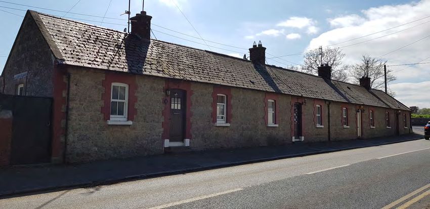
E Executive Summary

                  Sustainable Growth                                 Green Infrastructure & Water Services                                         Creating Communities

•     Support the expansion of Kinsaley Village centre as a focal    •   Improve the amenity of the River Sluice by providing a        •   Strengthen the local economy by providing opportunities
      point for the community with an enhanced retail function           riparian corridor for the enjoyment of residents and visi-        for expanded retail and local services around the pro-
      to serve the needs of existing and future residents.               tors.                                                             posed civic space in the village centre.
•     Support infrastructural investment to ensure safe              •   Protect and foster biodiversity by providing green routes     •   Expand the range of community infrastructure available
      pedestrian and cyclist movements throughout the village            that can facilitate the movement of fauna.                        to the growing population of Kinsaley by providing a per-
      in tandem with enhanced traffic management measures            •   Improve the liveability of Kinsaley by creating green links       manent national school, to replace the temporary Mala-
      including facilitating the provision of improved pedestrian/       between open spaces and other key assets, such as the             hide/ Portmarnock Educate Together national school.
      cycle access to public transport and local schools.                schools.                                                      •   Reduce the carbon footprint of new buildings by ensuring
•     Protect and enhance the existing natural amenities of          •   Mitigate flood risk by incorporating SuDS features into           that development is designed to minimise requirements
      Kinsaley together with improving access to established             new development and providing an undeveloped flood-               for energy and water.
      and proposed amenity areas through designated green                plain and riparian corridor to the River Sluice.              •   Creation of a high-quality, multifunctional civic space to
      routes.                                                        •   Take advantage of the opportunities created by the re-            serve the community.
•     Provide for the integrated development of the village              quirement to incorporate SuDS features to ensure that
      and its growing population with the development of new             these areas enhance the landscape quality of the area.
      housing delivered in tandem with supporting community          •   Protect water quality by ensuring that new development
      and physical infrastructure.                                       is designed so that water runs through at least one SuDS
                                                                         feature before discharge.

            Movement and Transport                                       Parks, Open Space and Recreation                                        Design and Development

•     Reduce local reliance on the private car by providing new      •   Meet the sporting and recreational needs of the growing       •   Define the character of Kinsaley as a rural village through
      pedestrian and cyclist infrastructure.                             population by providing a full sized/all-weather soccer           design and layout cues, such as the incorporation of
•     Facilitate pedestrian and cyclist movements around the             pitch and mixed use games area as part of the expanded            pitched roofs and appropriate and interesting gabled ele-
      village without the requirement to use main roads, insofar         school.                                                           vations and street furniture.
      as possible.                                                   •   Create a more active and vibrant village centre by provid-    •   Define the centre of Kinsaley as a village centre rather
•     Resolve traffic conflicts and inappropriate traffic                ing a new high quality civic space as part of Development         than as a suburban centre through the design of build-
      movements by providing dedicated school drop-off and               Area  4 - Malahide Road West.                                     ings and the civic space.
      parking areas.                                                 •   Improve opportunities for off-road movements around           •   Create a settlement with a distinctive rural character
•     Facilitate the upgrade of the Baskin Lane junction to allow        the village by providing a high quality green route               through the use of innovative, high quality architecture.
      traffic to flow more freely through the village                    through Development Area 3 (Teagasc) and Development          •   Ensure that sufficient capacity exists in the sewerage net-
                                                                         Area 6 (Kinsaley House), connecting to the Malahide               work by supporting the construction of a new Irish Water
                                                                         Road.                                                             pumping station to serve Kinsaley.
                                                                     •   Improve the range of amenities available to children by       •   Reduce surface water run-off by maximising permeable
                                                                         providing a playground to serve the broader area within           areas and incorporating features such as water butts,
                                                                         Development Area 3 (Teagasc).                                     rainwater harvesting, rain gardens, and permeable pave-
Table 1: Key goals of the LAP                                                                                                              ments.

 ix                                                                                                                                                      Kinsaley Local Area Plan : DRAFT
                                                                                              February 2019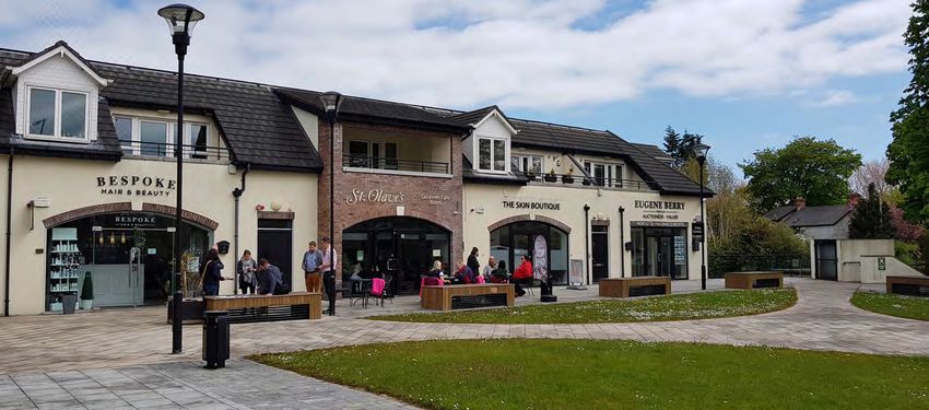
Executive Summary E
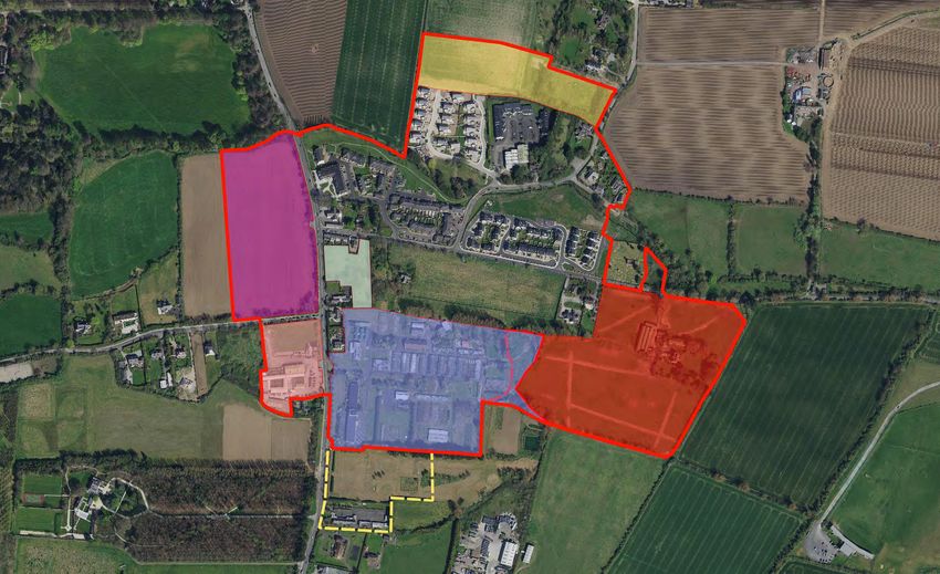
Kinsaley LAP
Existing and proposed elements:
24 • Proposed Baskin Lane Upgrade
1 • St. Olave’s
25 • Proposed village centre surface treatment
•
22
2 St. Nicholas of Myra Church and parish hall
26 • Development Plan roads objective
3 • Abby Well Kinsealy Lane Area
26
4 • Cooper’s Wood 21
21
5 • Kinsealy Woods (under construction) 7
6
12
6 • Kinsealy Business Park Bypass
Kinsealy Bussiness Park
7 • Emsworth Park 26
8 • Kinsealy House (protected structure) 1
St. Olaves
12
9 • Proposed Civic Space bounded by ground floor shops
St. Nicholas of Myra Church
10
• Proposed Local convenience shop
9 Square
Village
2 3
10
25
11 • Proposed residential development 4
12 • Proposed extended/ upgraded riparian corridor Malahide Road West
23
11
• Redeveloped Garden Centre site incorporating residen-
Malahide Road East
13 11 5
tial
14 • Proposed expanded national school 24
15 • Proposed Mixed Use Games Area (MUGA)
Garden Centre Area 18 Kinsaley House
16 • Proposed Full sized soccer pitch (all-weather) 8
Teagasc 11
19
17 • Car parking/ drop off for schools/ sports facilities 13 Playground
Greenway
20
18 • Proposed dispersed residential blocks in a landscaped Malahide/Portmarnock National School
Kinsaley House Area
setting
19
14
• Proposed green route for pedestrians/ cyclists
MUGA Pitches
19 18
15
20 • Proposed playground
17
21 • Landscaping buffer to adjoining development Football Pitch
16
22 • Serviced sites accommodating houses
23 • Residential development incorporating extension to Kin-
sealy Woods and development fronting Malahide Road
Kinsaley Local Area Plan DRAFT February 2019 x1 Introduction
1.0 Statutory Context these routes means that it experiences a significant volume of
A Local Area Plan (LAP) is a statutory document prepared through traffic.
in accordance with Part II, Section 20 of the Planning and
Development Act 2000 (as amended). As a statutory document, The lands surrounding Kinsaley are largely agricultural in
the Planning Authority and An Bord Pleanála must take account character, combined with the demesne lands of large country
of the provisions of the LAP when considering an application houses, including Abbeville to the north-west and Emsworth to
for planning permission for development. the south.
The purpose of this LAP is to examine Kinsaley in detail, The primary vehicular driving route to Kinsaley is the R107
identifying and analysing the various issues affecting the area Malahide Road which passes northwards from the city
and then establishing and setting principles for its future boundary, through the village. In terms of rail provision, the
development. LAPs prepared in consultation with the local nearest Dublin Area Rapid Transit (DART) stop is at Portmarnock
community and other stakeholders, create opportunities to to the east of the village.
strengthen and enhance local areas. When prepared for new
greenfield areas, they provide the opportunity for the creation Kinsaley has a strong visual identity and landscape quality
of sustainable communities and new placemaking. formed by the Sluice River, running east-west through the
village and by the stone walls and mature trees associated with
Objective PM13 of the Fingal Development Plan 2017-2023 the nearby Abbeville Demesne.
states as follows regarding LAPs:
The village core is centred on the parish church, the cottages
“Prepare Local Area Plans for areas designated on Development on Chapel Road and the developed lands at St. Olave’s local
Plan maps in co-operation with relevant stakeholders, and actively centre with associated residential development. Functionally,
secure the implementation of these plans and the achievement of the village can be described as a Commuter Village under
the specific objectives indicated”. development pressure. Recent construction includes the
Cooper’s Wood development along Chapel Road and the
Kinsaley Village is primarily zoned ‘RV – Rural Village’ in the Emsworth Park development on Kinsealy Lane. The Kinsealy
Development Plan. It is a stated objective of the Development Woods development is currently under construction.
Plan to:
Kinsealy Business Park provides employment, comprising light
“Protect and promote the character of the Rural Village and industrial units and offices and is accessed from Kinsealy Lane.
promote a vibrant community in accordance with an approved Until recently, the Teagasc site to the south of the village offered
Local Area Plan, and the availability of physical and community research based employment but, following consolidation of the
infrastructure”. research function into the Teagasc Centre in Blanchardstown,
has ceased operation. Other employment providers are focused
As such, it is a requirement of the Development Plan to prepare on existing retail services along Malahide Road, including at
a LAP for Kinsaley. Kinsealy Garden Centre.
1.1 Geographic Context 1.2 Purpose of the Local Area Plan
Kinsaley is located approximately 1.5 kilometres west of This LAP establishes a framework for the planned, coordinated
Portmarnock and 2.5 kilometres north of the suburban and sustainable development of Kinsaley, both within the
outskirts of Dublin City. Dublin Airport is 4.5 kilometres to the village core, in the surrounding lands zoned Objective RV –
west. The village is situated around the junction of Chapel Road ‘‘Rural Village’ defined herein as ‘Development Areas’ and
and Malahide Road and the junction of Malahide Road and on infill sites. The LAP will take effect for a period of 6 years
Baskin Lane. The Malahide Road facilitates north-south traffic following adoption (2019-2025), which may be extended for
movements, while Chapel Road and Baskin Lane facilitate an additional 5 year period (in the fifth year) as provided for
east-west traffic movements. The village’s location along under the Planning and Development Act 2000 (as amended).
1 Kinsaley Local Area Plan : DRAFT
February 2019Introduction 1
The LAP seeks to achieve the successful integration of the new nature and scale of development proposed and its potential future development, which must comply with the objectives of
Development Areas into the existing settlement of Kinsaley impacts. The SEA screening document is contained in Appendix the report to ensure impacts on water quality and increased
and in so doing, improving the liveability and quality of life of 4. flood risk are avoided.
the overall settlement.
1.5.2 Appropriate Assessment
1.3 Why a Local Area Plan for Kinsaley? In addition to the SEA screening exercise, it is also a requirement
As stated previously, it is a requirement of the zoning for to undertake an Appropriate Assessment (AA) screening
the area to prepare an LAP for Kinsaley. While this objective regarding possible impacts of the LAP on Natura 2000 sites
applied to much of Kinsaley under the previous Development as required under the EU Habitats Directive. The screening
Plan (2011-2017), the adoption of the Development Plan (2017- exercise concluded that a full Appropriate Assessment was not
2023) has had the effect of significantly expanding the ‘RV’ area. required. The AA Screening document is contained in Appendix
In addition, the cessation of the research activities previously 5.
undertaken at the Teagasc lands, which is a major component
of the LAP area, has reinforced the need to produce an LAP to 1.5.3 Sustainable urban Drainage Systems (SuDS) Analysis
guide future development and consolidate the village. A Surface Water Management Plan comprising both a flood
risk assessment and a sustainable drainage strategy has been
1.4 Pre-Draft Consultation developed for Kinsaley by Roughan & O’Donovan Consulting
At the end of May 2018, the Council published a Strategic Engineers (ROD) on behalf of Fingal County Council. The Plan
Issues Paper for Kinsaley entitled ‘Having Your Say’. The Paper identifies various recommendations and measures that should
was intended to generate interest and constructive debate and be employed, taking account of the existing surface water
to assist stakeholders and the public in making a submission/ infrastructure in place across the village. The SuDS strategy for
raising issues for consideration in the LAP. The consultation Kinsaley sets out a hierarchy of SuDS techniques, which when
period ran for 6 weeks, concluding on 13th July 2018. A total employed in combination, work together to form a coherent
of 36 no. submissions were received during this time, each of and effective strategy. The recommendations for Kinsaley
which has been carefully considered in the making of this Draft incorporate a range of source controls including:
LAP. A public drop-in information session was held in Kinsaley
on 13th June 2018 as a part of the public consultation activities • Source Controls - water butts, rainwater harvesting,
and was well attended. A summary of the issues raised by permeable pavements, green/blue roofs, green walls, filter
submitters is contained in Appendix 1. drains and soakaways.
• Site controls - swales, bioretention areas/ modified planters,
1.5 Environmental Assessments and detention basins.
The following environmental assessments have been • Possible regional controls - ponds and constructed wetlands.
undertaken to assess any possible impacts arising from the
Draft LAP. A copy of the Environmental Assessments are These SuDS measures shall, where feasible, be incorporated
contained within the appendices. into the development in line with appropriate sustainable
drainage practices and provide for limiting runoff rates and
1.5.1 Strategic Environmental Assessment site, source and regional controls.
A screening exercise was carried out in relation to whether a
Strategic Environmental Assessment (SEA) is required for the 1.5.4 Flood Risk Assessment
Local Area Plan (Directive 2001/42/EC). The SEA screening report In accordance with the ‘Planning System and Flood Risk
was sent to the Environmental Protection Agency, the relevant Management Guidelines for Planning Authorities’ (DoEHLG,
government departments and to adjoining Local Authorities, 2009) and Circular PL02/2014, (August 2014), the preparation
seeking comment. A copy of the SEA Screening Statement and of the LAP was the subject of a Strategic Flood Risk Assessment,
a summary of the responses received is included as Appendix which was also completed by ROD Consulting Engineers. The
1 of this document. The screening exercise for SEA concluded report incorporates commentary on each of the development
that a full Environmental Report was not required, given the areas identified in this LAP as well as recommendations to guide
Kinsaley Local Area Plan DRAFT February 2019 22 Legislative Context
2.0 Introduction 2.2 Regional Planning • New development should contribute to maintaining
The preparation of this Draft LAP has been guided by EU The Regional Planning Guidelines aim to implement the policies compact towns and villages and walking and cycling should
Directives, the National Planning Framework, Regional and objectives of the NSS (which, as stated previously, has been be preferred for local trips.
Planning Guidelines and by the Fingal Development Plan 2017- superseded by the NPF) at a regional level. • Higher densities are appropriate in some locations that
2023, in addition to various Government policy documents and are served by existing and/ or planned public transport
guidelines. The need to promote sustainable development is Following the enactment of the Local Government Reform corridors.
clearly articulated in the aforementioned documents and has Act 2014, three new Regional Assemblies came into effect in • Development should offer alternatives to urban generated
been central to the preparation of this Draft LAP. Sustainable January 2015, replacing the previous Regional Assemblies. As housing where pressure for single homes in rural areas is
development refers to “development that meets the needs of the stated above, Fingal is part of the Eastern and Midland Regional high.
present without compromising the ability of future generations to Assembly (EMRA). Each Assembly produces a Regional Spatial • The scale of new residential development schemes should
meet their own needs”. and Economic Strategy (RSES) which will, when adopted, be in proportion to the pattern and grain of existing
supersede the current RPGs. Future Development Plan reviews development. It is generally preferable for development
2.1 National Planning Framework 2018-2040 will be required to comply with the RSES, including any review to take place on a number of sites, rather than on a single
The National Planning Framework (NPF) is the long-term of the housing allocation in the Core Strategy resulting from large site.
strategic planning framework that will guide national, regional updated population projections. • Local authorities have a vital role to play in encouraging
and local planning and investment over a 25 year period. In development through the provision of essential services.
contrast to its predecessor, the National Spatial Strategy 2002 The current RPGs distinguish the Metropolitan area from the
(NSS), the NPF will have a statutory basis and is accompanied Hinterland area of Fingal by setting out distinct development 2.4 S. 28 Guidelines for Planning Authorities
by a sister document, the National Development Plan 2018 strategies for each. Kinsaley is located in a rural area within The guidelines for planning authorities have been prepared
(NDP). The NDP is a 10 year strategy for the capital investment the designated Dublin Metropolitan Area. The RPGs divide and issued by the Department of Housing Planing and Local
of almost €116 billion, known as Project Ireland 2040. these villages into two categories, Commuter Villages and Key Government (previously Environment, Community and Local
Villages. Kinsaley is designated as a Commuter Village. The Government) under section 28 of the Planning and Develop-
The NPF recognises the importance of the Eastern and Midland current RPGs indicate that future growth in Commuter Villages ment Act 2000 (as amended) to guide best practice planning
Region as a major source of growth in the Country over the should be managed so that they do not facilitate the expansion and development.
next 20 years and states as follows in this regard: of unsustainable growth patterns.
Local Area Plan Guidelines
“The Eastern and Midland part of Ireland will, by 2040, be a region The Draft RSES acknowledge that the area has undergone rapid The guidelines set out best practice for the preparation of new
of around 2.85 million people, at least half a million more than population growth over the past 10 years and that small towns LAPs. The main aims of the guidelines are to:
today”. and villages which are located in proximity to the large urban
centres, experience significant urban generated pressures. This • highlight best practice and improve the quality of LAPs
As the population of the Region grows, so too will the need requires the levels of growth to be managed and to ensure that • improve community and institutional participation in the
for additional resources in the form of housing, employment, there is a requisite service level for the population. As a rural process of preparing or amending local area plans; and
infrastructure and transport. village in the Dublin Metropolitan Area, Kinsaley is experiencing thereby
these pressures. • enhance the co-ordination and provision of essential public
The NPF goes on to state that: infrastructure within the planning process.
2.3 Sustainable Residential Development in Urban Areas -
“The significant influence of Dublin and the cross border network Cities, Towns & Villages 2009 The Kinsaley LAP has been prepared with regard to the LAP
extends to the county towns and other settlements within the The guidelines for Planning Authorities aim to support guidelines, as well as all other applicable guidelines issued un-
north-eastern regional area as well as to Fingal and parts of County the development of sustainable communities through the der Section 28.
Meath. In identifying opportunities for leveraged employment and incorporation of best practice standards and by providing a
sustainable population growth, development must be supported coordinated approach to the delivery of infrastructure and 2.5 Transport Strategy for the Greater Dublin Area 2016-
by enhanced connectivity, quality of life, strengthened urban cores services in cities, towns, and villages. The main objectives of 2035
and more compact housing in urban settlements. This is to protect the guidelines for small towns and villages are: The Transport Strategy for the GDA provides a framework for the
and manage the strategic capacity of transport infrastructure and planning and delivery of transport infrastructure and services
to ensure that the distinctiveness of settlements and rural areas is • Development must be plan led either through an adopted up to 2035. Smarter Travel, A Sustainable Transport Future
maintained”. Local Area Plan or Village Design Statement. 2009-2020, also seeks to promote sustainable development, by
3 Kinsaley Local Area Plan : DRAFT
February 2019Legislative Context 2
reducing emissions, through the promotion of cycling, walking of the total residential capacity for the Metropolitan Area. The Vision Statement for the RV zoning seeks to:
and sharing car journeys. The likely number of additional residential units in Kinsaley in
The Greater Dublin Area Cycle Network Plan was published in the long term will be circa 565 units (including extant planning “Protect and promote established villages within the rural landscape
2013 and is a ten year cycling strategy for Dublin, Kildare, Meath permissions/ areas under construction as of the time of writing). where people can settle and have access to community services.
and Wicklow. While the proposed network for rural areas does This constitutes approximately 1.4% of the allocation for the The villages are areas within the rural landscape where housing
not show a link through Kinsaley, it does propose an ‘Urban/ Metropolitan Area of 39,909. needs can be satisfied with minimal harm to the countryside and
Town Network’ route along Station Road in Portmarnock surrounding environment.
extending as far west as the R124, as well as a link along the The anticipated number of additional units in Kinsaley are
Feltrim Road, extending as far south as Kettles Lane and calculated as follows: The villages will serve their rural catchment, provide local services
connecting onward to the Swords-Malahide route. and smaller scale rural enterprises. Levels of growth will be managed
Extant Planning Permissions (Total 182 units): through Local Area Plans to ensure that a critical mass for local
2.6 Kinsaley Cycleway and Footpath Network Feasibility • Kinsaley House - 100 no. units services is encouraged without providing for growth beyond local
Study • Kinsealy Woods (under construction) - 82 no. units need and unsustainable commuting patterns”.
Fingal County Council has commissioned a cycling and footpath
feasibility study for the Kinsaley area which examines the While a planning permission exists for the construction of The OS zoning objective seeks to:
feasibility of a number of walking and cycle routes connecting 100 units at the Kinsaley House site, construction has not yet
the village to neighbouring settlements. It is an objective of the commenced. It is, therefore, possible that a subsequent planning “Preserve and provide for open space and recreational amenities”.
LAP to improve cycling connections. application will be prepared based on the level of development
supported for Development Area 6 in this Draft LAP. The overall
2.7 Fingal Development Plan 2017-2023 figure quoted herein assumes that the permission for 100 no.
The Fingal Development Plan 2017 – 2023 is the statutory units will be constructed and, as such, may vary.
framework for the County which sets out the Council’s
policies and objectives for development over the Plan period. Identified Development Areas (Total 483 units)
The Development Plan seeks to develop and improve, in a • Development Area 1 - 30 no. units (approx)
sustainable manner, the social, economic, environmental and • Development Area 2 - 40 no. units (approx)
cultural assets of the County. The Draft Local Area Plan has had • Development Area 3 - 185 no. units (approx)
due regard to all relevant policies and objectives set out in the • Development Area 4 - 85 no. units (approx)
Development Plan. • Development Area 5 - 20 no. units (approx)
• Development Area 6 - 123 no. units (approx)
2.7.1 Core Strategy
The Planning and Development (Amendment) Act 2010 The identified yield is likely only to be realisable over a period
introduced the requirement for an evidence based ‘Core longer than the statutory time period of the LAP and that of the
Strategy’ to be included in Development Plans. The purpose of Fingal Development Plan 2017-2023.
the Core Strategy is to require local authorities to identify and
reserve appropriate areas of land in suitable locations to meet 2.7.2 Land Use Zonings
the housing and population targets set out for the Region. LAPs The Fingal Development Plan zones land in Kinsaley primarily as
prepared by the Local Authority must be consistent with the Rural Village - ‘RV’. However, the Development Plan also defines
allocations set out in the Core Strategy. areas of Open Space ‘OS’, Local Centre ‘LC’, and Community
Infrastructure ‘CI’ zonings within the village.
Fingal’s Core Strategy indicates that there is a total capacity
of 49,541 housing units on zoned lands for the County, The RV zoning objective seeks to:
split between the Metropolitan Area (39,909 units) and the
Hinterland area (9,632 units). The total residential capacity on “Protect and promote the character of the Rural Village and
zoned lands in the ‘Other Settlements’ category, which includes promote a vibrant community in accordance with an approved
Charlestown & Meakstown, Santry & Ballymun, Balgriffin & Local Area Plan, and the availability of physical and community
Belcamp, Baskin & Kinsaley, is 2,791. This figure represents 7% infrastructure”.
Kinsaley Local Area Plan DRAFT February 2019 42 Legislative Context
The Vision Statement for the OS zoning seeks to: The Vision Statement for the GB zoning states as follows: “The villages, as a collective, are a valuable rural asset to the
County that needs to be protected from excessive inappropriate
“Provide recreational and amenity resources for urban and “Create a rural/urban Greenbelt zone that permanently demarcates development. Their function as either Key Villages or Commuter
rural populations subject to strict development controls. Only the boundary (i) between the rural and urban areas, or (ii) between Villages within the Metropolitan and Hinterland areas, as defined
community facilities and other recreational uses will be considered urban and urban areas. The role of the Greenbelt is to check in the RPGs, is an important determining factor for the scale
and encouraged by the Planning Authority”. unrestricted sprawl of urban areas, to prevent coalescence of and type of development proposed, but of equal importance
settlements, to prevent countryside encroachment and to protect is preserving the uniqueness of all our villages, acknowledging
The CI zoning objective seeks to: the setting of towns and/or villages. The Greenbelt is attractive their contribution to the cultural richness of the County.
“Provide for and protect civic, religious, community, education, and multifunctional, serves the needs of both the urban and
health care and social infrastructure”. rural communities, and strengthens the links between urban and Settlement within the designated Rural Villages will continue to
The Vision Statement for the CI zoning seeks to: rural areas in a sustainable manner. The Greenbelt will provide be open to all. The settlement strategy will not require that a
opportunities for countryside access and for recreation, retain person is from a rural or urban area. This policy will promote the
“Protect and promote an inclusive County, accessible to all members attractive landscapes, improve derelict land within and around vitality of the villages and facilitate the provision of appropriate
of the community, facilitating the sustainable development of towns, secure lands with a nature conservation interest, and facilities. This is a policy response to the low levels of growth
necessary community, health, religious, educational, social and retain land in agricultural use. The zoning objective will have the in many of the villages over recent years. However, the level of
civic infrastructure. A wide range of different community facilities, consequence of achieving the regeneration of undeveloped town growth within villages must be managed. Rapid expansion will
civic facilities and social services exist within the County ranging areas by ensuring that urban development is directed towards not be permitted as it would put undue pressure on services and
from those of regional importance such as education and health these areas”. the environment and encourage higher levels of unsustainable
facilities, to those of local and neighbourhood importance such as commuting. The level of growth will be managed through the
places of worship, community centres and childcare facilities. It 2.6.4 Rural Settlement Strategy Core Strategy and the Local Area Plan process”.
is important to facilitate the development and expansion of such Section 5.2 of the Development Plan sets out the Rural
services in order to deliver a quality environment whilst improving Settlement Strategy, which guides the location of residential 3.6.5 Local Objectives
the quality of life for all”. development within the rural area. The rural area of Fingal is The Development Plan includes the following map based local
recognised as being under ‘Strong Urban Influence’ and as such objectives within Kinsaley:
The LC zoning objective seeks to: seeks to provide for rural-generated housing need within the
rural area, while directing urban-generated housing need into Local Objective 67
“Protect, provide for and/or improve local centre facilities”. towns and villages. The Strategy indicates policies and objectives Facilitate a traffic impact assessment of the junction of Chapel
for villages, clusters and houses in the open countryside, as Lane with the Malahide Road and, subject to an identified need and
The Vision Statement for the LC zoning seeks to: well as objectives for layout and design associated with each resources being available, carry out improvement works to same.
settlement type.
“Provide a mix of local community and commercial facilities for Local Objective 69
the existing and developing communities of the County. The aim is The Development Plan seeks to achieve the following for Facilitate a traffic impact assessment of the junction of Baskin Lane
to ensure local centres contain a range of community, recreational Fingal’s Rural Villages (Statement of Policy, Development Plan, with the Malahide Road and, subject to an identified need and
and retail facilities, including medical/ dental surgeries and page 147): resources being available, carry out improvement works to same.
childcare facilities, at a scale to cater for both existing residential
development and zoned undeveloped lands, as appropriate, at • Promote attractive and vibrant villages Local Objective 71
locations which minimise the need for use of the private car and • Ensure sustainable expansion and development at a level That any development of this area will include the integration of
encourage pedestrians, cyclists and the use of public transport. The appropriate to and integrated with the existing village the Protected Structure on site (Kinsaley House) within the first
development will strengthen local retail provision in accordance • Meet the socio-economic and civic aspirations of the phase of development.
with the County Retail Strategy”. community, whilst at the same time affording maximum
environmental protection
2.6.3 Zoning of Adjacent Lands • Preserve the villages’ distinctive character, heritage, amenity
‘GB’ (Green Belt) zoned land separates Kinsaley from and local identity
surrounding settlements. The GB zoning objective seeks to:
The Development Plan further states that:
“Protect and provide for a Greenbelt”.
5 Kinsaley Local Area Plan : DRAFT
February 2019Environmental Issues and Opportunities 3
3.0 Introduction • RPS No. 914 – Malahide/Portmarnock Educate Together
Existing development in Kinsaley primarily comprises housing National School at Malahide Road, Kinsaley. A mid-20th
with a limited range of local services. The presence of century symmetrical multi-bay former research building
employment land (or former employment land) is also a feature in the international style (main building only, excluding
of the village. The Kinsaley Business Park is located to the north glasshouses and other office and research buildings on the
of the Sluice River, while the Teagasc lands, which previously site).
accommodated an agricultural research centre, represent a • RPS No. 464 – Kinsaley House, Chapel Road, Kinsaley,
large landholding within the southern portion of the LAP area. Malahide, Co. Dublin. An early 18th century five-bay two-
storey house.
3.1 Landscape Character
The LAP lands are located within the designated ‘Low Lying The following Protected Structure is located just outside the
Agricultural’ character type as defined in the Development LAP boundary:
Plan. This area is characterised by a mix of pasture and
arable farming on low lying land with few protected views or • RPS No. 455 – Church (in ruins) & Graveyard at Chapel
prospects. The Low Lying Agricultural character type has an Road, Kinsaley, Malahide, Co. Dublin. Remains of medieval
open character combined with large field patterns, few tree church within enclosed graveyard (outside of LAP bound-
belts and low roadside hedges. ry).
The low lying character type is dominated by agriculture with a Abbeville House and its associated Architectural Conservation
number of settlements and is categorised as being of modest Area (ACA) plays an important role in the heritage of Kinsaley. It
value. However, it contains pockets of important landscape value is located outside of the rural village boundary and therefore is
requiring particular attention such as important archaeological not within the confines of this LAP. It is protected under the Fin-
monuments and demesnes. gal Development Plan 2017-2023 (RPS No. 452) and described as:
• “18th century nine-bay two-storey house, stables, out-
A portion of the LAP area to the west of the Malahide Road is buildings & walled garden”.
located within the ‘Highly Sensitive Landscape’ designation. A
Highly Sensitive Landscape is likely to be vulnerable to change Under Section 81 of the Planning and Development Act 2000 (as St. Nicholas of Myra Church
whereas a landscape with a low sensitivity is likely to be less at amended) ACAs are designated in order to preserve the char-
risk from change. acter of a place, area, group of structures or townscape that is dedication to St. Nicholas of Myra. The side and transepts of the
either of special architectural, historical, archaeological, artis- church are painted pebble dash with stained glass windows.
3.2 Historic Character tic, cultural, scientific, social or technical interest or value, or The tower/ belfry is located to the rear of the structure, beyond
There are four Protected Structures of architectural and that contributes to the appreciation of Protected Structures. the transepts and apse. The accompanying parish hall is single
historical interest within the LAP boundary. These buildings and storey with its gable fronting the Malahide Road. The parish
sites are included on the National Inventory of Architectural 3.3 Existing Built Form hall is finished and painted to match the church.
Heritage owing to their contribution to various categories of
The following locations characterise the existing form of
special interest such as architectural, artistic, social, etc. The Former Teagasc Research Centre
development within the village and contribute to its character
Protected Structures are as follows: The Teagasc complex was formerly in use as an agricultural re-
and setting:
search centre and consists of two rows of glass houses (cur-
• RPS No. 913 – Road Bridge located at Malahide Road, rently disused), extensive areas of vegetation, and research/
St. Nicholas of Myra Church and Parish Hall
Kinsaley, Co. Dublin. As per the description contained within administrative buildings, including a protected structure (RPS
A key feature of the built environment in Kinsaley is St. Nicholas
the Development Plan’s Record of Protected Structures, the No. 914), which as previously stated is a mid-20th century sym-
of Myra church and Parish Hall, located at the junction of the
road bridge is a mid-18th century triple-arch masonry road metrical multi-bay former research building in the internation-
Malahide Road and Chapel Road. The church was constructed
bridge over river. al style.
to a ‘T’ plan, which was typical of the period (1830s). The facade
• RPS No. 454 – St. Nicholas of Myra Church (RC) at Malahide
to the Malahide Road consists of a statue of the Virgin Mary
Road (R107), Kinsaley, Malahide, Co. Dublin. This is a mid-
above the front door with the pediment above. The pediment
19th Century Catholic Church, tower and school building.
contains somewhat oversized lettering containing the
Kinsaley Local Area Plan DRAFT February 2019 63 Existing Environmental Issues and Opportunities
Chapel Road Cottages 3.4 Recent Construction
The cottages to the southern side of Chapel Road are centrally Kinsaley has experienced a comparatively high level of
located within the village and date from the 19th Century. As residential development in recent years, as compared to the
such, their location and character make them a defining feature. size of the settlement (108 dwellings in the 2011 census/ 150
The row of cottages comprises five dwellings, of single storey dwellings in the 2016 census).
height with grey slate roofs, stone frontages and red brick
detailing around the windows and doors. The cottages have The following development has taken place over approximately
a relatively uniform presentation to Chapel Road, each with the past 10 years:
approximately 9-10 metres of road frontage. All of the cottages
have been extended to the rear, with remaining gardens Emsworth Park
generally measuring from 5 metres to 9 metres in depth. The dwellings in Emsworth Park are of contemporary design,
but incorporate elements which reference more traditional
‘One-off’ Housing forms of rural buildings. The dwellings are generally large (225
In addition to the cottages along Chapel Road and more recent sq.m) and are detached two storey structures, with gable roofs
housing developments, Kinsaley also accommodates a number in grey tile. Facades are white painted render. The design of
of ‘one-off’ dwellings in a range of locations. These dwellings the houses moves away from the typical suburban design
range from imposing two storey ivy-clad brick and painted with wide plan and shallow pitched roof to create a narrower
pebble dash structures, to more modern dormer bungalows of building form intended to be more in keeping with traditional
a type not uncommon in the Irish countryside. The size, finish rural housing, including a gabled elevation to the road. The
and style are varied as might be expected of one-off dwellings. design also incorporates a variety of pitched roofs and mono-
pitches over secondary, single storey elements. Emsworth Park Residential Scheme
Cooper’s Wood
The Cooper’s Wood development consists of two storey
dwellings with gable roofs finished in a varied yellow brick.
Roofs consist of grey tiling with chimneys in brick to match the
front façade. Rear and side elements are in a cream painted
render. Window frames are generally a uniform finish, with
some windows being of narrow width, with elongated height.
Tiling on front porches matches roofs.
The Cooper’s Wood estate was completed in recent years,
with the last units being marketed in September 2016. The
development has a total of 38 dwellings of 3/4 bedrooms.
The Emsworth Park scheme includes 16 large 4-bedroom
houses, and is undergoing final marketing and sales.
Abby Well
The Abby Well development consists of a collection of both
one and two storey dwellings in red brick with grey tiled roofs.
A small proportion of the houses also incorporate rendered
painted surfaces. Single storey dwellings generally consist of
gabled roofs, while the double storey dwellings consist of hipped
roofs with protruding elements. The single level dwellings are
Chapel Road Cottages generally detached, while the double storey dwellings are
7 Kinsaley Local Area Plan : DRAFT
February 2019You can also read