East West Link (Eastern Section) Assessment Committee Request for Information under section 57(4) of the Major Transport Projects Facilitation Act ...
←
→
Page content transcription
If your browser does not render page correctly, please read the page content below
East West Link (Eastern Section) Assessment Committee
Request for Information under section 57(4) of the Major
Transport Projects Facilitation Act 2009
Response of the Linking Melbourne Authority
11 February 2014

                                                           1
1 Introduction
On 13 January 2014 the East West Link Assessment Committee (the Committee) issued a
Request for information under section 57(4) of the Major Transport Projects Facilitation Act
2009 (the Request) to the Linking Melbourne Authority (LMA) as project proponent for the East
West Link (Eastern Section) Project (the Project).
This document complete with Appendices A - Q contains the LMA's response to the
Committee's Request in accordance with the Committee's directions dated 20 January 2014.
This response adopts the same headings, sub-headings and paragraph numbering as the
Request by the Committee with the specific request preceding LMA's response.
This response should be read in conjunction with the Comprehensive Impact Statement (CIS)
prepared by LMA for the Project which contains additional detail and technical assessments on
many of the matters contained in this response. The CIS is available at:
www.linkingmelbourne.vic.gov.au

                                                                                                2
2 Terms of Reference and assessment of scope
The LMA is requested to provide its opinion on the interpretation of the following:

1.           Whether the Assessment Committee (AC) is constrained by the Terms of References dated 21
             October 2013 (TOR) in terms of its powers, function and discretions under ss 73(4)-(5) and 236(2)
             of the Major Transport Projects Facilitation Act 2009 (the Act) in any way and, if so, what way?

             The Committee’s first question can be broken into two parts:

                        a.     First, whether terms of reference issued by the Planning Minister
                               under section 35(b) of the Major Transport Projects Facilitation Act
                               2009 (Vic) (the Act) can bear upon the operation of sections 73(4),
                               73(5) and 236(2) of the Act; and

                        b.     Second, if the answer to the first question is yes, whether the
                               particular Terms of Reference issued by the Planning Minister to the
                               Committee in this instance (the Terms of Reference) do in fact
                               constrain the Committee in any way.

             It is convenient, before addressing these specific matters, to first outline the relevant
             statutory framework within which the Committee has been established, and within
             which it is required to operate.

             The Legislative Framework

             Two parts of the Act are particularly relevant in this respect:

                        a.     Division 5 of Part 3 of the Act provides for the establishment of
                               assessment committees and describes the manner in which they are
                               to assess comprehensive impact statements prepared in respect of
                               declared transport projects; and

                        b.     Part 8 of the Act concerns assessment committees specifically,
                               containing (amongst other things) the administrative provisions
                               relating to the formation and functioning of assessment committees,
                               as well as provisions relating to the conduct of hearings by
                               assessment committees.

             The critical parts of this framework for present purposes are those concerning the
             establishment of assessment committees and those defining the role that terms of
             reference play in the assessment process.

             The establishment of assessment committees is governed by Subdivision 2 of
             Division 5 of Part 3 of the Act.

             Section 35 of the Act provides that, after publishing the scoping directions for a
             comprehensive impact statement, the Planning Minister “must”:

                        a.     establish an assessment committee in accordance with Part 8 of the
                               Act to assess the comprehensive impact statement;1 and

                        b.     “give the assessment committee the terms of reference under which it
                               will assess the comprehensive impact statement in accordance with
                               this division” (emphasis added).2

1
    Section 35(a).
                                                                                                             3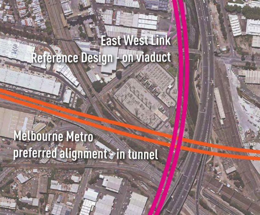
It is clear as a consequence that terms of reference issued by the Planning Minister
           under section 35 play an important role in defining the manner in which an
           assessment committee is to undertake its assessment of a comprehensive impact
           statement.

           Indeed, given the strict terms of section 35,3 an assessment committee has no power
           to undertake its assessment of a comprehensive impact statement otherwise than in
           accordance with such terms of reference.

           The provision makes clear, in addition, that the terms of reference are to influence
           each aspect of an assessment committee’s assessment of a comprehensive impact
           statement under Division 5 of Part 3 of the Act (which, relevantly for present purposes,
           includes sections 73(4) and 73(5) of the Act).

           The matters that can be the subject of direction under terms of reference are specified
           in section 36 of the Act. They include, but are not limited to,4 directions concerning:

                       a.    the conduct of the preliminary hearing;5

                       b.    “the matters which the assessment committee is to consider”;6

                       c.    the matters that may be “under consideration at a public hearing”;7
                             and

                       d.    the conduct of cross-examination.8

           Two observations are made in respect of this provision:

                       a.    First, that terms of reference issued by the Planning Minister are in no
                             way limited to procedural or administrative matters, and can properly
                             operate to define the matters that an assessment committee can
                             consider in assessing a comprehensive impact statement.

                       b.    Second, that the Act draws a distinction between the matters that an
                             assessment committee must consider in assessing a comprehensive
                             impact statement, and the matters that may be considered at a public
                             hearing conducted in accordance with Subdivision 7 of Division 5 of
                             Part 3 of the Act. Indeed, it is clear that the Act expressly
                             contemplates that the scope of matters that can be the subject of
                             consideration at the public hearing can, depending on the terms of
                             reference, be more confined than those that must be taken into
                             account by an assessment committee in making its ultimate
                             recommendation to the Planning Minister. As will be discussed in
                             greater detail below, this is what has occurred here with respect to the
                             Terms of Reference.

2
  Section 35(b).
3
  In particular the use of the word “will” in the context of the obligation on the part of an assessment
committee to assess the comprehensive impact statement in accordance with the terms of reference.
4
  Section 36(2) makes clear that the list of non-exhaustive matters identified in section 36(1) does not limit
what may be included in the terms of reference given to an assessment committee.
5
  Section 36(1)(a).
6
  Section 36(1)(b).
7
  Section 36(1)(ba).
8
  Section 36(1)(c).
                                                                                                            4
Further, terms of reference are relevant not only to the role of an assessment
           committee. The Act makes clear that they also determine the matters that can be
           validly made in public submissions concerning a comprehensive impact statement.
           Indeed, section 52(3)(e) provides that a submission is not properly made unless it “is
           within the scope of the terms of reference of the assessment committee”.

           The Terms of Reference and Sections 73(4), 73(5), and 236(2) of the Act

           The first part of the Committee’s question relates specifically to the interaction
           between Terms of Reference and sections 73(4), 73(5), and 236(2) of the Act.

           Sections 73(4) and 73(5) concern the matters that an assessment committee must
           have regard to in making an assessment committee recommendation. These matters
           include:

                       a. the project proposal;9
                       b. the CIS;10
                       c. all properly made submissions;11
                       d. any issues raised in meetings and correspondence referred to in
                          consultations undertaken pursuant to section 56 of the Act, a
                          preliminary hearing, or a formal public hearing;12
                       e. the comments of the persons that were consulted in accordance with
                          a direction of the Planning Minister;13
                       f. any consultation with or advice received from an applicable law
                          decision maker;14 and
                       g. every applicable law relevant to the declared project including the
                          applicable law criteria under that law.15

           An assessment committee may, in addition, have regard to “any other matter the
           committee considers relevant”.16

           The fact that these matters do not expressly include any terms of reference issued by
           the Planning Minister does not mean that an assessment committee’s assessment of
           a comprehensive impact statement can proceed without regard to those terms of
           reference.

           On the contrary, for those reasons set out above, terms of reference are expressly
           intended to define, and / or confine, the scope of an assessment committee’s powers
           and obligations under the entirety of Division 5 of Part 3 of the Act (which includes
           sections 73(4) and 73(5)).17

           Sections 73(4) and 73(5) of the Act must accordingly be read in conjunction with, and
           subject to, the matters specified in any terms of reference.

           This is made clear by section 73(2) which provides that an assessment committee
           “must not” make an assessment committee recommendation that is “inconsistent with
           the committee’s terms of reference”.

9
  Section 73(4)(a).
10
   Section 73(4)(b).
11
   Section 73(4)(c).
12
   Section 73(4)(d).
13
   Section 73(4)(e).
14
   Section 73(4)(f).
15
   Section 73(4)(g).
16
   Section 74(5).
17
   Section 35(b).
                                                                                                    5
It follows that the Act, when properly construed, requires that an assessment
             committee:

                          a. must conduct its assessment of a comprehensive impact statement in
                             accordance with any directions contained within its terms of reference;

                          b. must, in doing so, have regard to those matters identified in sections
                             73(4) and 73(5); and

                          c. must not make an assessment committee recommendation that is
                             inconsistent with its terms of reference.

             The matters specified in section 73(4) and 73(5) cannot operate to expand or modify
             the scope of any terms of reference. Where section 74(5) provides that an
             assessment committee can have regard to “any other matter the committee considers
             relevant” in making its recommendation, those additional matters must be matters that
             fall within the scope of the terms of reference. If they are not within that scope, they
             cannot properly be regarded as relevant to the assessment that the assessment
             committee is required to conduct.

             This much is made explicitly clear by Part 8 of the Act.

             Section 236(2) provides, in this respect, that:

                   “[s]ubject to this Part, in carrying out its functions in relation to a matter referred
                  to it by the Planning Minister, an assessment committee may inquire into and
                  inform itself in relation to the matter in any manner it sees fit” (emphasis added).

             Section 251, which forms part of Part 8 of the Act, expressly provides that:

                  “an assessment committee may take into account any matter it thinks relevant in
                  making an assessment committee recommendation, subject to any directions
                  given to it by the Planning Minister” (emphasis added).

             That terms of reference constitute “directions” from the Planning Minister is (for the
             purposes of this provision) made clear by the express terms of section 36 of the Act,
             which specifies the type of “directions” that the Planning Minister may include in terms
             of reference.

             To What Extent do the Terms of Reference Issued by the Planning Minister to
             this Assessment Committee “Constrain … [its] Powers, Functions, or
             Discretions”?

             The second part of the Committee’s first question calls for a detailed examination of
             the Terms of Reference issued by the Planning Minister to this Committee on 21
             October 2013.

             The Terms of Reference make clear, at the outset, that the “powers, functions and
             discretions” of the Committee are “subject to the Terms of Reference”.18 They
             similarly specify, in respect of the preparation of an assessment committee
             recommendation and report, that the Committee’s power to carry out an assessment
             of the CIS is “subject to the terms of reference”.19

18
     Clause 1.
19
     Clause 1(3)(a).
                                                                                                             6
An important direction in this respect is set out in clause 1(3)(b) of the Terms of
             Reference (which forms part of the identification of the “task” of the Committee).

             The Committee is required, in making its recommendations to the Planning Minister in
             respect of whether he should make an approval decision that grants any, some, or all
             of the applicable approvals that are necessary for the Project, to confine its
             assessment to a project that may be implemented (in the sense of aligned) on land
             that is within the project boundary. It is entitled to assess alternative alignments for
             the project that may be implemented within the project boundary but not beyond.

             The Committee may, for instance, consider whether parts of the Project should, or
             should not, be contained within a tunnel within the project boundary. Further, it may
             consider and assess the merit of any specific alternative alignment if that alignment
             can be implemented within the project boundary (for instance, some of those identified
             by the City of Melbourne, the proposed modification of the Elliott Avenue interchange,
             or some alternative to the Elliott Avenue interchange that can be aligned within the
             project boundary).

             The Committee cannot, however, assess an alignment for the Project (either above or
             below ground) if that alignment cannot be implemented within the project boundary.

             Furthermore, the Committee is precluded from making any recommendations to the
             Planning Minister that would require the Project to be aligned outside of the project
             boundary as part of its ultimate assessment committee recommendation, as to do so
             would be inconsistent with the Terms of Reference.

             Another important component of the Terms of Reference is the distinction between
             the matters that the Committee must consider in undertaking the task of assessing the
             Project – set out in Part 1 of the Terms of Reference – and the more limited matters
             that can be the subject of the formal public hearing – set out in clause 2(7) of the
             Terms of Reference.

             The first limitation in this respect is that the formal public hearing must be confined to
             “properly made submissions”.20 As noted above, in order to qualify as a “properly
             made submission”, a submission must be made within the scope of the Terms of
             Reference (and be otherwise in accordance with section 52(3) of the Act).
             Submissions that propose alignments for the project outside of the project boundary
             accordingly do not qualify as such.21

             This is not to say that documents submitted to the Committee that contain a number
             of contentions on discrete issues must be disregarded in their entirety if they propose
             such alternatives. Rather, it is only those contentions contained within a document
             that concern matters that are outside the scope of the Terms of Reference that must
             be disregarded by the Committee.

             A further set of limitations in respect of the permissible scope of the formal public
             hearing is set out in clauses 2(7)(a) – (i) of the Terms of Reference. These matters
             are limited to an examination of the extent to which the Project will give rise to a series
             of different impacts and whether those impacts have been appropriately addressed
             and / or managed.

20
     Clause 2(7).
21
     Section 52(3)(e).
                                                                                                          7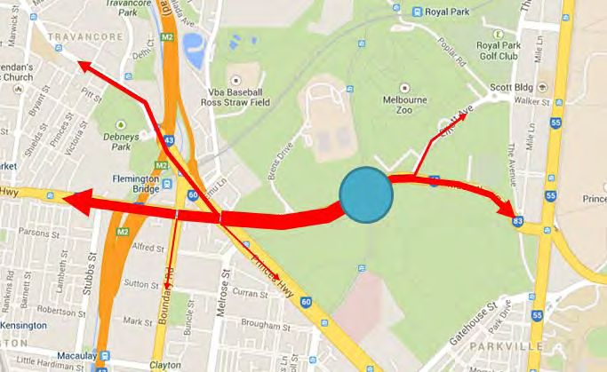
2.   Having regard to Task 1(3)(b) of the TOR, is the "Figure 1 (dated 2 October 2013)" referred to
     therein the same as Figure 1 (dated 3 October 2013), entitled "Overview", in the CIS Mapbook that
     has been provided to the AC?

     Yes, LMA understands that the reference to “2 October 2013” is a typographical error,
     and that the correct reference should be “3 October 2013”.

3.   What does the term "project boundary" referred to in Task 1(3)(b) mean?

     It is convenient, for the purposes of addressing this question, to set out clause 1(3)(b)
     in full:

          In preparing the Assessment Committee Recommendation and report, the
          Assessment Committee is directed to:
                     …
                 (b)     consider the alignment, design and performance requirements for
                         the project that may be implemented within the project boundary
                         identified in Figure 1 (dated 2 October 2013) of the Mapbook.

     Figure 1 of the Mapbook presents an “overview” of the East West Link (Eastern
     Section) Project in the sense that it illustrates a cross-city road link spanning from the
     Eastern Freeway in the east to CityLink and the Port of Melbourne in the west.

     Whilst the overview provided within Figure 1 is contained within the proposed project
     boundary, it does not delineate the proposed project boundary.

     As is evident from the express terms of the balance of the Mapbook, the proposed
     project boundary is instead delineated as a blue dotted line on each of the detailed
     road alignment plans (being drawings EWL-DES-DR-1100 – EWL-DES-DR-1130)
     contained within the Mapbook.

     The reference to the project boundary in Task 1(3)(b) can and should be read as
     being consistent with this delineation.

     LMA contends that the phrase “Figure 1 (dated 2 October 2013) of the Mapbook” is
     intended, in the context of clause 1(3)(b) of the Terms of Reference, to describe the
     “project” (as shown in overview in that Figure) as opposed to the “project boundary”.

     If follows that Task 1(3)(b), properly construed, should be read as follows:

                   In preparing the Assessment Committee Recommendation and report,
                  the Assessment Committee is directed to:
                       …

                       (b)    consider the alignment, design and performance requirements
                              for the project[,] that may be implemented within the project
                              boundary[,] identified in Figure 1 (dated 2 October 2013) of the
                              Mapbook.

     Thus the words “that may be implemented within the project boundary” qualify the
     word “project”, and, in this context, “implemented” effectively means “aligned”.

     Thus, the Committee must confine its consideration to an assessment of the
     alignment, design and performance requirements for a project that may be
     implemented within the project boundary, and more specifically, the Project identified
     in Figure 1 of the Mapbook.

                                                                                                     8
It is also important to bear in mind the distinction between the terms “project
           boundary” as used in the Terms of Reference, and “project area” which is defined in
           section 3 of the Act as follows:

                 project area, for a declared project or an approved project, means the area of
                 land designated by Order under section 95, as varied by Order under section 96
                 or consolidated by Order under section 97.

           Pursuant to section 95(2)(b), the designation of an area of land as the project area
           must (in the present circumstances) be made by the Minister after the making of an
           approval decision with respect to the Project. This is because the Governor in Council
           has not declared the Project to be a “declared project to which this Act (other than
           Parts 3 and 8) applies”.22

           Accordingly, the reference to project boundary in the Terms of Reference must be
           read and understood as being the area that is proposed to ultimately form the project
           area. However, the designation as to what land will ultimately comprise the “project
           area” is a matter for the Minister that must necessarily occur after the making of the
           approval decision. It is not part of the approval decision.

           Further, because the designation of the project area is not part of the approval
           decision, the extent of the project area is not a matter that the Committee can, or
           should, consider.

4.         Is the ability of the AC to recommend conditions to any grant of an applicable approval under
           s73(3) of the Act constrained in any way, and if so what way to the area that is defined by the
           dotted blue line as the "proposed project boundary" within sheets 1‐27 and the alignment
           concept contained in the CIS Mapbook (the proposed project boundary)?

           Section 73(3) of the Act provides that if, as part of its written report to the Planning
           Minister the Committee recommends that the Planning Minister grant all or some of
           the required applicable approvals, the Committee must specify:

                       (a)    The conditions;
                       (b)    The relevant applicable law under which the conditions are being
                              imposed; and
                       (c)    The person or body authorised under the relevant applicable law to a
                              Planning Minister to administer compliance with the conditions.

           For the reasons identified above, the Terms of Reference make clear, at clause
           1(3)(b), that the scope for the Committee to consider the Project is limited to a project
           that may be implemented within the geographical area delineated as the proposed
           project boundary.

           In this context, it is necessary to have regard to the terms of the declaration of the
           Project that has been made under section 10(1)(a) of the Act (“the Declaration”) to
           understand what comprises the Project. The declared project is described in the
           Declaration as:

                             …the transport project known as the East West Link Project (Eastern
                             Section) being the proposed freeway-standard link between the
                             Eastern Freeway and the Tullamarine Freeway generally along the

22
   See: Declaration Of A Transport Project, dated 19 December 2012 made by the Governor in Council
and published in the Victorian Government Gazette No.S 446 on 20 December 2012. See also section10
of the Act, which allows for two alternative forms of declaration, and identifies that the declaration in this
instance has been made under section 10(1)(a).

                                                                                                             9
Alexandra Parade corridor, with a further southerly connection to the
                      Port of Melbourne area …

     Two things are clear from this definition. Firstly, the declared project is one that is
     identified as being “…generally along the Alexandra Parade corridor”. Thus, there is
     no scope for the Committee to consider a project along any other corridor, including
     the alternative northern and southern corridors that are identified in the CIS.

     Secondly, the declared project is comprised of the “proposed freeway-standard link”
     and the “further southerly connection”. This does not include mitigating roadworks,
     facilitative or consequential works, or enhancement actions that may be either
     necessary or desirable.

     In view of the above matters, there is accordingly no scope for the Committee to
     recommend, by way of condition on any applicable approval to be issued in respect of
     the Project, any change to the alignment of the Project that cannot be implemented
     within the project boundary.

     This is not to say, however, that the Committee’s assessment of the impacts of the
     Project are limited to this area, or that it cannot recommend conditions in respect of,
     or that may impact upon, land that is outside of the project boundary.

     A project of this magnitude will clearly have impacts beyond the project boundary
     delineated in the Mapbook and the Committee can, and should, consider and assess
     those impacts within the scope of its Terms of Reference. Where those impacts
     warrant conditions affecting land outside of the project boundary, or which require
     some actions (other than the declared project itself) to be taken on land outside the
     project boundary, then those conditions could be validly recommended (subject to the
     proviso identified above and subject to them otherwise meeting the tests for the
     validity of conditions that apply in the context of each of the applicable laws).

     An example of conditions in relation to land outside of the project boundary might be a
     condition requiring mitigating road works in proximity to the Project, or a condition
     requiring that an offset be secured on land in respect of native vegetation removal
     permitted as part of the Project. Another example would be a condition requiring the
     monitoring of noise impacts on locations that are outside of the project boundary.

5.   Is the ability of the AC to consider the development (as opposed to the impact) of the declared
     project limited only to the area within the proposed project boundary?

     For those reasons set out above the answer to this question is yes. The Committee is
     required to confine its assessment of the Project to the extent that it may be
     implemented (in the sense of aligned) within the project boundary.

6.   If the answer to question 4 and / or 5 is yes, is the ability of the AC to consider further options
     under Part 3 Division [5] Subdivision 8 of the Act constrained in any and, if so, what manner,
     other than by the Subdivision provisions themselves?

     The scope for the Committee to consider further options under Subdivision 8 of
     Division 5 of Part 3 of the Act is limited to freeway alignments that can be
     implemented within the project boundary.
     Subdivision 8 of Division 5 of Part 3 of the Act sets out a mechanism for the
     preparation of supplementary comprehensive impact statements.

     It allows, in “exceptional circumstances”, for an assessment committee to recommend
     to the Planning Minister that the Planning Minister direct that a supplementary
     comprehensive impact statement be prepared in respect of a “prudent and feasible
     alternative to the preferred option contained in the comprehensive impact statement”.
                                                                                                           10
There are a number of preconditions to an assessment committee making a
recommendation to the Planning Minister under this provision:
a. the first is that a “further option” must be identified in the course of “a
formal public hearing” or “a properly made submission”;
b. the second is that an assessment committee must consider that the
further option provides a “prudent and feasible alternative to the
declared project”;
c. the third is that an assessment committee must consider that the
further option “has not been given sufficient consideration”; and
d. the fourth is that an assessment committee must be satisfied that
“exceptional circumstances” exist which warrant the preparation of a
supplementary comprehensive impact statement.23
The Terms of Reference influence the first of these preconditions in two important
respects:
a. first, they limit the matters that can be properly addressed at the
formal public hearing to those matters identified in clause 2(7) of the
Terms of Reference; and
b. second, they define what constitute “properly made submissions”.
As described above, the Terms of Reference preclude consideration of further options
for the Project as part of the formal public hearing (other than to the extent that they
fall within the matters identified in clause 2(7)), and preclude further options being
explored within properly made submissions (other than to the extent that the further
options can form part of a project that may be implemented within the project
boundary in accordance with clause 1(3)(b)).
Furthermore, and equally importantly, the Terms of Reference expressly apply to the
entirety of Division 5 of Part 3 of the Act (which includes Subdivision 8 of Division 5)
and are intended to direct the basis upon which the Committee assesses the CIS.
Consistent with the task that the Committee is charged to perform under the Terms of
Reference, there is no scope for the Committee to make a recommendation under
section 69(2) in respect of any further options for the Project, other than in respect of
those further options that can be implemented within the project boundary, and that
the Committee considers have not been adequately addressed within the CIS.
Additional Matters
Direction 25 of the Committee’s Directions issued on 20 January 2014 (the
“Directions”) requires that the LMA “[i]nclude in its response to Questions 1 to 6 of
Document 1 (the section 57(4) paper), a response to matters raised by Yarra City
Council including whether the LMA intends to revise the CIS, and the implications of
this …”.
As indicated at the Preliminary Hearing the LMA does not intend to revise the CIS.
The LMA understands that the remainder of the matters referenced in direction 25 of
the Directions, being matters raised by Yarra City Council at the Preliminary Hearing,
23
Section 69(3) provides guidance concerning what constitutes exceptional circumstances in this respect.
11were matters consequential on the preparation of a revised CIS by the LMA. They
accordingly do not arise for consideration in this instance.
123 The Reference Project
3.1 Consideration of alternatives
7. The LMA should advise what alternatives were considered (if any) and then discounted for
inclusion in the reference project for the following project elements. An explanation of why any
alternatives were discounted should be provided.
The development of the Project involved the consideration of a broad range of
alternatives, including alternative alignment and interchange options to the north and
south of the preferred alignment, as well as a range of tunnelling, surface and
elevated road way configurations which might be implemented within the preferred
alignment.
In discussing alternatives which were considered during the Reference Project
development, including alternative options proposed in submissions, it is important to
stress that the design of East West Link (and every other major road project) is
constrained by well-established Australian design rules and safety standards which
cannot be compromised. These are set out in further detail below but include
Austroads Guidelines and the VicRoads Supplement to these guidelines.
A summary of this consideration of alternatives is set out in Volume 1, Chapter 4 of
the CIS, as is a summary of the reasons why the central corridor was ultimately
chosen as the preferred alignment.
With regard to the identified project elements, the following options were the main
alternatives considered in developing the Reference Project.
(a) The rationale for the major tunnel construction methods proposed;
The CIS does not mandate the use of any particular tunnel construction method for
the construction of those parts of the Reference Project that are identified as being
within a tunnel.
Rather, the CIS identifies performance requirements that must be achieved, including
those with regard to noise and vibration, regardless of the major tunnel construction
method that is ultimately employed.
However, in the preparation of the CIS, regard has been had to the most likely forms
of tunnel construction method that may be employed, as a means of identifying and
assessing possible impacts. In this regard, there are four principal tunnelling methods
that are currently used to construct road tunnels. These are:
road header excavation, where specialised machines grind the tunnel
face to break out the rock in the tunnel profile;
excavation by tunnel boring machine (TBM), where the TBM removes the
full area of the tunnel face as it progresses along the tunnel alignment;
top down construction, where a slot from the surface is excavated and
covered enabling the tunnelling space to be provided; and
drilling and blasting, where hard rock is removed by the use of explosives.
Melbourne's other major road tunnels (CityLink and EastLink) were constructed using
road headers, with some minor use of explosives where the rock became particularly
hard. However, ongoing improvements in TBM technology mean that these machines
are now able to be constructed at a size which would accommodate a three lane
13traffic envelope (15 + metre diameter), and therefore, for the East West Link (Eastern
Section) tunnels, TBM excavation would be a practical tunnelling method.
However, TBMs are expensive items and the tunnel needs to be sufficiently long to
justify their selection. In the case of East West Link (Eastern Section), where the
tunnels are around 4.4km, TBM excavation is likely to be a cost effective option.
While the CIS does not mandate the tunnel construction method that must be used, in
calling for tenders the LMA has required that a conforming tender be one where the
majority of the tunnel is to be excavated below the surface employing one or more of
methods 1, 2 and 4 identified above.
This means that top down or cut and cover construction would not be allowed except
in the areas approaching the portals (and identified as such in the Reference Project)
where this method would be necessary or desirable for technical reasons.
Summary
The development of the Reference Project has considered all the likely tunnel
construction methods that might be utilised for the construction of those parts of the
Reference Project that are identified as being within a tunnel. The CIS does not
propose any particular method of tunnel construction, nor discount any method (other
than top down tunnelling construction in the areas approaching the portals, and as
identified in the Reference Project). Construction of the majority of the tunnel using
the top down construction method was discounted because of the extensive adverse
impacts that such a process would have on the existing urban environment.
The CIS identifies the likely impacts of tunnel construction, and identifies performance
requirements that must be met, regardless of the particular method (or methods) that
is ultimately employed.
(b) The location and design for tunnel portals and ventilation outlets;
Although a range of options were considered for the East West Link (Eastern Section)
connection, the decision to require a long tunnel was made in order to minimise the
impacts of the Project.
In effect, the full length of the connection between the Eastern Freeway and CityLink
is proposed in the Reference Project to be located in tunnel, except where it is
necessary to achieve connections to those existing freeways. This means that the
alignment will generally pass under the residential and commercial areas along
Alexandra Parade, Princes Street, the Melbourne General Cemetery, and most of
Royal Park.
At each end of the tunnel the roadways being connected are either at the surface or
elevated. Accordingly, it is necessary for the portals to be located in such a way that
the connecting ramps can pass to and from the tunnel.
The locations for the tunnel portals that are identified in the Reference Project
represent locations where it is possible to achieve an acceptable connection with
existing surface or elevated road structures.
Other than in terms of general location, the precise design of the portals and any
associated ventilation outlets is not mandated by the CIS. Rather, the CIS identifies
performance requirements that must be met regardless of the final location, and / or
design of the portals and ventilation outlets.
14With respect to the design of the portals and the ventilation outlets, these performance
requirements will include a requirement to achieve the outcomes identified as
appropriate by the Urban Design Framework prepared for the Project.
In terms of ventilation, the CIS recognises and acknowledges that ventilation of the
tunnels will be required to meet operational and safety requirements. For a tunnel of
the length and type that it is proposed in the Reference Project it is expected that
longitudinal ventilation would be employed. This means that air is drawn into the
tunnel in the direction of traffic and extracted from the tunnel near the exit portal.
Therefore, it is necessary for a ventilation station to be constructed at, or near, the
location of each tunnel portal. It is possible that the necessary ventilation equipment
could be accommodated in underground chambers meaning that the ventilation shaft
would be the only visible component of the ventilation system.
However, the CIS does not mandate either the location or design of the ventilation
outlets. Rather, it prescribes performance requirements for the ventilation outlets that
must be achieved regardless of their final design and location. This will include
performance requirements specified in the CIS with regard to urban design, and
achieving appropriate environmental standards and outcomes.
Summary
Portal locations in the Reference Project have been identified on the basis that they
minimise the extent of surface roads, and yet at the same time still allow for a safe
and workable connection to existing surface and elevated roadways. Portal locations
that did not minimise the extent of impact on surface roads were discounted because
of the impact they would have on the existing urban environment, including Alexandra
Parade and Royal Park.
It is expected that ventilation systems will need to be co-located with the tunnel portal.
However, the CIS does not mandate any particular location or design of the necessary
ventilation systems. Accordingly, no ventilation location or design has been expressly
discounted. Rather, whatever the location and / or design, all performance
requirements will need to be met.
(c) Interchange designs, particularly at the Hoddle Street Interchange, Elliot Avenue,
Ross Straw Field, and connections from the existing road network to the project;
The operational success of Melbourne's freeway network depends in large part on the
connectivity between the freeways and the surface road system. It is necessary for
motorists to have frequent points of entry and exit so that they can effectively move
around the city.
A key consideration in the preparation of the Reference Project was the need to have
full connectivity between the Eastern Freeway / East West Link (Eastern Section) and
Hoddle Street at the eastern end.
At the western end, the obvious connections between East West Link (Eastern
Section) and CityLink provide for freeway to freeway connectivity, but do not connect
East West Link (Eastern Section) to the surface road network. The intersection of
Flemington Road, Mt Alexander Road and Racecourse Road to the North West of the
CBD provides a unique nucleus of transport linkages. Racecourse Road provides
connections with major arterial roads in the west such as Ballarat Road and Geelong
Road. Mt Alexander Road provides accessibility to the inner north west suburbs, while
Flemington Road and adjoining roads such as Boundary Road, provide linkages into
North Melbourne and the north of the CBD. As such, it was determined that a
connection to the surface road network in the vicinity of this important transport
15linkage would be of great value to the connectivity of the transport network as a
whole.
An interchange at Elliott Avenue was thought appropriate to provide the connectivity
to the surface roads in this area while also providing increased access to the
Melbourne Zoo, University of Melbourne and the medical precinct. If surface road
connectivity is not provided at these locations the Project would only cater for much
longer journeys and would provide a lower level of service to the community. With
respect to alternative interchange designs at these locations, there were many varied
design options considered and ultimately discarded before arriving at the
configurations provided in the Reference Project, some of which were:
Eastern End
At Hoddle Street, there were options developed which took the two East
West Link carriageways onto structure from the Eastern Freeway up and
over the Clifton Hill Rail Line and Hoddle Street bridge before descending
into tunnel on the Western side of Hoddle Street. This option was
discarded due to the high cost and perceived negative visual impact of
such significant freeway structures.
Other options considered the tunnel section starting to the east of Hoddle
Street, closer to Merri Creek. This option had constraints on tunnel
grades and the ability to provide safe and efficient ramp connections to
and from Hoddle Street. It was also a high cost option.
Consideration was given to proving the south to east movement from
Hoddle Street to the Eastern Freeway through a typical at-grade
intersection, however this provided a significant reduction in level of
service for this movement and further congested Hoddle Street in the
afternoon peak back towards Johnston Street. This option was discarded
in favour of the current Reference Project flyover for this movement which
provides a high level of service and the ability to provide bus priority.
The Reference Project interchange was ultimately chosen as it provides a
very neat solution of keeping the main East West Link carriageways on
the surface and descending into tunnel on the western side of Hoddle
Street while still fitting under the Hoddle Street bridge structure and within
the piers and abutments. This option also provided for all necessary ramp
movements in a safe and efficient configuration.
Western End
Many options were considered at this location which ranged from
elevated structures to tunnel alignments and at grade connections.
Some options considered the East West Link ramps joining CityLink in the
median rather than on the outside, although these were discarded
because of constructability issues, as they would have needed more
significant closures to CityLink during construction.
Options were considered which had a tunnel portal further to the east and
connected to an elevated viaduct on the eastern side of CityLink. This
was discarded due to the significant impacts on Royal Park, east of Ross
Straw Field and the significant private property acquisition required.
These options also required very complicated structures to cross CityLink
at the southern end near the Port of Melbourne for the full east west link
16connectivity. These structures would have had an even larger footprint
and associated private property acquisition and subsequent cost.
The Reference Project was selected as it was believed that this
arrangement of ramps provided the minimum impact on Royal Park, while
maintaining the required functionality with appropriately designed safe
and efficient connections.
The provision of a ramp connection to Ormond Road was considered
early in the project development but discarded due to design constraints
of previous options. As the Reference Project developed, the ability to
connect to Ormond Road northbound was more realistically achievable.
In addition, through the development of the CIS, it was determined that
this ramp would provide a superior traffic distribution outcome while
improving access to these north western suburbs.
In addition to the designs at these locations there were considerations for additional
connections from the tunnel to the road network in Carlton or Fitzroy. These options
were discarded due to their requirement for significant impact on private property
acquisition in this area, poor ramp grade outcomes, their high cost and traffic impacts
to these local areas. Overall the provision of ramps at these midpoint locations did not
fit in with the primary objectives of this Project to provide enhanced east to west
connectivity.
In the process of developing the Reference Project and the CIS, a wide range of
possible alternatives were considered for the various interchanges. Ultimately,
however, the final form of the interchange designs are controlled by basic geometric
requirements, provision for operational needs and traffic demands.
Traffic modelling has identified the anticipated volumes that would be likely to utilise
the various ramp connections. These volumes dictate the number of lanes required for
those intersections, and the number of stand-up lanes required at the intersections to
ensure that traffic is cleared as efficiently as possible through each signal phase. In
some instances, such as the north-bound to east-bound connection between Hoddle
Street and the Eastern Freeway, the predicted volume of traffic has led to the need for
a direct connection as reflected in the Reference Project “flyover”.
The length of the ramps is also influenced by a number of considerations. These
include the need to transition from an underground level to the surface or above at a
grade which supports efficient traffic movements. Grades of up to 6 % have been
considered for traffic emerging from the tunnel ramps, with 4 % for the main tunnel
carriageways. Higher grades than this would see the potential for stalling or very slow
traffic speeds for traffic queued back from a red signal. In addition, provision has to be
made for ramp metering storage so that the East West Link ramps can be operated as
part of Melbourne’s overall freeway management system. Ramp metering, which
releases vehicles individually to join the mainline traffic stream, means that traffic will
queue at the signal points. It is necessary to contain such queued traffic within the
ramp and not allow this queue to extend out onto the surface arterial roads.
Australian (and Victorian) road design standards also need to be accommodated.
Ramp tapers, which facilitate the smooth integration of ramp traffic into the through
traffic stream, have to meet geometric standards for the design speed. Similarly,
intersection geometry to accommodate large turning vehicles needs to be designed to
meet the appropriate standards. These standards also include elements such as
vertical and horizontal clearances to allow passage of legally registered vehicles and
to meet sight distance requirements.
17Within the framework of the above constraints, the Reference Project proposes
interchange configurations which are efficient, safe and workable, while at the same
time being aware of the need to minimise impacts on adjacent properties and
community facilities. At Hoddle Street, for example, the scope for variation in design is
limited. Although it would be possible to conceive a more complex arrangement, the
design process identified that physical impacts of such a design on the surrounding
community would be significantly greater than what is proposed in the Reference
Project. LMA has formed the view that the Reference Project would be able to
achieve an appropriate intersection connection, but at the same time minimise the
impacts as much as is possible.
The western interchange is similarly constrained and although variations to the
Reference Project are possible, the fundamental need to connect roadways emerging
from the tunnel to CityLink (with minimum impact) has once again resulted in the
outcome proposed in the Reference Project. The design for the Elliott Avenue
interchange has been developed with the objective of maximising the amount of
underground roadway and achieving connectivity to Elliott Avenue largely within the
current road reserve. Again, more elaborate interchange arrangements could be
developed to provide greater overall traffic capacity but these would be at the expense
of the loss of additional parkland and increased visual impacts.
Summary
Interchange designs which did not provide the necessary connectivity between the
freeways and surface road networks were discounted as they would not provide the
necessary traffic demands that this Project has to meet.
(d) Locations for a viaduct adjoining CityLink and Moonee Ponds Creek for the section
linking to the Port of Melbourne, in the context of the development of the Arden
Precinct, as well as existing land uses (including public housing at Debneys Park
Estate, and apartments in Bent Street) and waterway values; and
Port Connection along Moonee Ponds Creek
Several alternatives were considered for the Part B connection between Part A and
the Port area, including an alignment on the east side of CityLink, and continuation of
the tunnel under Flemington Road with a portal north of Sutton Street, North
Melbourne.
The assessment of the design alternatives had to consider the significant constraints
and existing features in this complex urban environment, which includes CityLink, the
Upfield rail line, major arterial roads, transmission power lines, and existing and
proposed residential areas.
Locating the Part B connection on the east side of the CityLink viaduct was assessed
as unfeasible because:
there is insufficient space between the rail line, CityLink and existing multi-
storey buildings on Racecourse Road;
it would have very significant negative impacts on Royal Park in relation to
removing parkland, disruption to sport facilities including community facilities
such as Urban Camp and visual amenity as the viaduct would need to start at
Elliot Avenue;
weaving distances between the entry ramp at Racecourse Road and the
Dynon Road exit would restrict the connection to CityLink; and
18 the Part B connection needs to be located on the western side of CityLink in
the port area, so it can connect to the western section of East West Link.
The option of continuing the tunnel to a portal north of Dynon Road and Sutton Street
was found to present substantial additional complexity, cost, and impacts on open
space and residential areas. In particular:
this option would require two pairs of two-lane tunnels, which would
considerably increase the cost to construct Part A and require higher impact
cut and cover construction in Royal Park near The Avenue, Parkville; and
the transition from the tunnel to and over CityLink would need to be located
north of Sutton Street, resulting in significant impacts on the Arden-Macaulay
area.
Each design option considered would have some impacts on residential and open
space areas.
In comparison with the options described above, LMA determined that the Reference
Project for the Port Connection would require less private property acquisition, reduce
impacts on Royal Park, significantly reduce the construction cost of Part A, and
enable greater connectivity.
(e) Location of temporary road alignments (i.e. for traffic diversions, laydown areas and
site compounds to be used during construction).
Temporary Road Alignments
The CIS does not identify the location of temporary road alignments, other than the
proposed temporary realignment of Alexandra Parade that is identified in the
Reference Project, in order to accommodate Alexandra Parade traffic during
construction (as the excavation for the cut and cover tunnel construction would
occupy the majority of the median and part of the eastbound carriageway in Alexandra
Parade from east of Gold Street to Wellington Street).
The CIS identifies possible locations for construction work sites, and possible impacts
including, in some cases, the need for traffic diversions. However, the final location of
such traffic diversions will be a matter to be determined with the successful tenderer
and will be subject to ensuring compliance with the relevant performance
requirements identified in the CIS.
However, in preparing the CIS and the Reference Project, it has been necessary to
have regard to the likely construction needs, and to identify how such needs might be
satisfied. For example, provision has been made for the temporary realignment of
Alexandra Parade to enable the transition between the Eastern Freeway and the
driven section of the tunnel to be accommodated. The only other possible
realignment would be on the southern side of Alexandra Parade and this was
considered but is likely to be less desirable because it would impact a greater number
of residential properties, result in greater local access disruption and involve more
complex construction staging. At the western end, it is expected that some temporary
realignment of roads such as Brens Drive and Manningham Street will be necessary
to facilitate construction.
In all cases, however, it will be necessary for those carrying out construction activities
to identify the location for temporary road alignments and other construction sites that
are capable of meeting the performance requirements identified in the CIS and which
are designed to minimise impacts on the community. The former Fitzroy Gasworks
site at the corner of Alexandra Parade and Smith Street, and the Melbourne
19Wholesale Fruit and Vegetable Market site on Footscray Road, are included in the
project area and are available for project related purposes. Both sites are State
owned land and could be used for project office purposes, workforce parking, storage
of equipment and materials.
Summary
Whilst alternative temporary road alignments were not discounted, the provision that
has been made to accommodate construction of the Reference Project is considered
to be reasonable, and to represent an acceptable means of managing construction
activity so as to minimise impacts.
8. The LMA should provide a response to proposed design modifications, including but not limited
to:
(a) City of Melbourne's suggested use of the existing CityLink viaduct for the East West
Link and other modifications proposed in section 2.1 of its submissions;
2.1.1: The City of Melbourne considers that the existing City Link viaduct
between the Port of Melbourne and Flemington Road provides sufficient
capacity until 2031 and that Section B of the Project is not required
LMA considers Part B to be an essential component of the East West Link.
The need for improved cross-city connections has been clearly articulated in Sir Rod
Eddington’s East West Link Needs Assessment Study and outlined in Section 1 of the
CIS.
The CIS has been prepared on the basis that the East West Link (Eastern Section)
would ultimately form part of a full East West Link between Hoddle Street,
Collingwood and the Western Ring Road, Deer Park.
To achieve the full East West Link, it is necessary to provide the section parallel to
CityLink between Footscray Road and near Flemington Road, as proposed in the CIS.
When the full East West Link is in operation, the existing CityLink would not have the
capacity to carry both the north-south travel demand catered for by CityLink, and the
60,000 vehicles per day expected to use the Port Connection once the full East West
Link is in place.
It is therefore necessary to secure the corridor for Part B (Port Connection) to allow its
construction at the earliest possible opportunity and provide certainty for land use
changes as proposed in the Arden-Macaulay precinct.
2.1.2 and 2.1.3: The City of Melbourne submission considers that the proposed
Arden Street Ramps be removed and the local road network in the Arden-
Macaulay precinct be improved
As the Arden-Macaulay area develops into a significant employment and residential
inner urban precinct over the coming decades, it is imperative that good access be
provided, including, if practicable, from the East West Link.
It is considered that this access could be provided by a half diamond interchange at
Arden Street that incorporates a grade separation with the Upfield rail line, associated
bridgeworks over Moonee Ponds Creek, road works at Lloyd Street and Arden Street,
as proposed in the Reference Project.
Future provision of East West Link ramps at Arden Street would provide direct access
from the freeway network into the precinct, thus reducing road traffic demand on the
20arterial road network in the area. LMA is of the view that the land identified for future
provision of the Arden Street ramps should be reserved as part of this planning
process.
2.1.4: Melbourne City Council has requested that the Upfield Rail Line between
Flemington Bridge and Macaulay be upgraded.
Upgrading the Upfield Rail Line is outside of the scope of the East West Link (Eastern
Section) Project. The Project however makes allowances to ensure that any future
upgrade is not precluded.
2.1.5: If needed in the long term, allow for a tunnel link connection between
Royal Park and the Port of Melbourne.
The possibility of an extended tunnel link was considered as part of the Reference
Project options development, as outlined in CIS Volume 1, Chapter 4. As the CIS
explains, this option was discounted for a number of reasons.
Firstly, the geology of the area and presence of low strength Coode Island silt
materials along Moonee Ponds Creek and in Dynon / Footscray Road area is
unsuitable for constructing large diameter tunnels.
Secondly, even without these conditions, the additional tunnel length would increase
construction costs significantly.
(b) City of Melbourne's suggested options outlined in section 2.2 of its submission to
reduce the impacts of the Western Portal on Royal Park and West Parkville including
the:
i. Wetland Option
ii. Earth mound Option
iii. Alternative Ramp Alignment Option
2.2.3.1 Wetland option, and 2.2.3.2 Earth Mound option
In principle, LMA has no objection to either the Wetland or the Earth Mound options,
as proposed in the City of Melbourne submission. In principle, they represent
possible means by which the impacts of the Project could be mitigated. Each could
also provide individual benefits depending on the option.
However, while these options have merit, they have not been the subject of detailed
scrutiny, and the feasibility of such options would need to be fully considered in the
context of:
functionality of connection ramps to CityLink;
their relationship in horizontal and vertical planes;
geology under Ross Straw Field (i.e. Coode Island silt)
settlement implications;
detailed design;
capital cost;
social and environmental impacts; and
ability to meet the performance requirements.
LMA considers that the design depicted in the Reference Project represents an
acceptable and appropriate outcome having regard to the considerations above, and
one that it considers would be able to meet the performance requirements identified
in the CIS.
212.2.3.3: Alternative ramp alignment option
The City of Melbourne has suggested an alternative arrangement with regard to the
area around Manningham Street and the Ross Straw Field. The City of Melbourne is
not proposing any change to the north bound connections to City Link, but is
proposing alternatives to the two south bound connections.
The City of Melbourne alternative proposals as presented are schematic only and
have not been fully developed so as to demonstrate feasibility. Accordingly, LMA is
not in the position to fully respond to the proposed design modifications, but provides
the following preliminary comments:
(i) North bound ramp from CityLink to EWL
This option was considered as part of the detailed planning for the East West Link
(Eastern Section), however, it was rejected, because:
the design radius of the curve is approximately 240 metres which
is not acceptable from a design speed and safety perspective;
such ramp would constrain, and possibly prevent, construction of
the Port Connection (Part B) as currently proposed by the
Reference Project; and
the proposed structure is located within 6 metres of the façade of
the “Lombard” Building on Mt Alexander Road.
(ii) South bound ramp from East West Link to City Link
The City of Melbourne submission proposes a ramp from the tunnel portal along an
elevated viaduct above the Upfield rail line from the East West Link crossing right
through to Racecourse Road.
Whilst a design in exactly this form has not previously been considered by LMA, it is
similar to a design option that was considered by LMA for the Port Connection to the
east of CityLink, but ultimately discounted.
Having regard to the outcomes of that assessment, LMA does not support the proposed
design modification. It considers that the proposed modification would:
have significant implications on tunnel design and in-tunnel
operation arising from the proposal for three consecutive exit
ramps (i.e. exiting ramp to Elliott Avenue, the City of Melbourne
proposed ramp to CityLink southbound, and the East West Link
Port Connection (Part B) southerly ramp);
require more extensive cut and cover construction in Royal Park
to provide four tunnel lane cross section, as ground conditions are
unsuitable for adopting below surface tunnel methods;
impact on private property both to the north and south of
Flemington Road that is currently not affected by the Reference
Project;
have additional visual impacts, as the ramp would be over the
elevated section of the Upfield rail line; and
have higher capital cost.
22You can also read