Hayling Island Transport Assessment - Addendum January 2020 - Havant Borough Council
←
→
Page content transcription
If your browser does not render page correctly, please read the page content below
Hayling Island Transport Assessment | Addendum | January 2020
1

    Hayling Island Transport
    Assessment
    Addendum
    January 2020
    Issue level 1.01
Hayling Island Transport Assessment | Addendum | January 2020

Hayling Island Transport
Assessment
Addendum
January 2020
The Hayling Island Transport Assessment Addendum has been prepared by Havant Borough Council with
traffic modelling from Systra.

Any queries about the report should be sent to:
Email        policy.design@havant.gov.uk
Telephone    023 9244 6539
Address:     Havant Borough Council
             Public Service Plaza
             Civic Centre Road
             Havant
             PO9 2AX

        Version    Date
        0.3        06/09/2019     For initial peer review                  SM
        0.4        22/10/2019     For peer review                          SM      DH
        0.5        25/10/2019     Finalisation                             SM
        0.6        31/10/2019     Finalisation                             SM      JB
        0.7        07/11/2019     HIIG review                              SM      JB
        0.8        07/01/2020     HCC and HIIG comments                    SM      DH
        1.01       29/01/2020     Final for issue                          SM      DH

                                                                                          Page | 1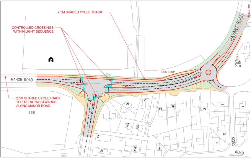
Hayling Island Transport Assessment | Addendum | January 2020
Contents
1. EXECUTIVE SUMMARY ............................................................................................................. 4
GLOSSARY AND ABBREVIATIONS ............................................................................................. 6
TABLES AND ILLUSTRATIONS .................................................................................................... 7
2. INTRODUCTION AND BACKGROUND...................................................................................... 8
3. THE ADDENDUM ...................................................................................................................... 11
Status of this document ............................................................................................................................................... 11
Reason for the Addendum ........................................................................................................................................... 11
What has changed in this Addendum? ....................................................................................................................... 12
What hasn’t changed in this Addendum? .................................................................................................................. 13
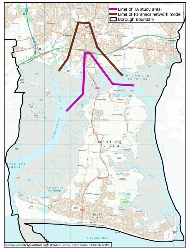
4. TRAFFIC MODELLING RESULTS ........................................................................................... 14
Summary: proposed interventions ............................................................................................................................. 14
‘Do Something’ Interventions and Mitigation ............................................................................................................. 19
Modelling Results: Do Something 2036 ...................................................................................................................... 36
Model Run Results Summary ...................................................................................................................................... 43
Further Work .................................................................................................................................................................. 43
5. LANGSTONE ROUNDABOUT .................................................................................................. 45
6. OTHER TRANSPORT NETWORK IMPROVEMENTS AND INTERVENTIONS .................... 49
Bus Network .................................................................................................................................................................. 49
Ferry ............................................................................................................................................................................... 51
Walking and Cycling Network ...................................................................................................................................... 52
Smarter Choices ‘Soft Measures’ ................................................................................................................................ 59
Demand Management ‘Hard Measures’ ...................................................................................................................... 60
7. THE HAYLING BILLY TRAIL .................................................................................................... 65
History ............................................................................................................................................................................ 65
Page | 2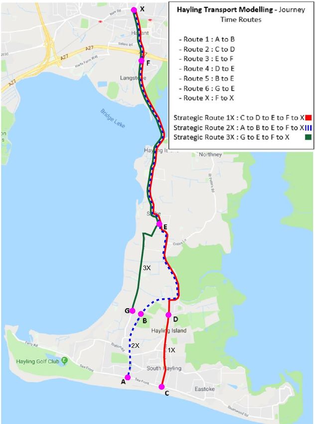
Hayling Island Transport Assessment | Addendum | January 2020
Status ............................................................................................................................................................................. 66

Transport Role ............................................................................................................................................................... 67

Future Opportunities .................................................................................................................................................... 70

Summary ........................................................................................................................................................................ 73

8. SOCIETAL IMPACTS OF MITIGATION .................................................................................... 75

9. FUNDING AND DELIVERY ....................................................................................................... 77

10. SUMMARY AND CONCLUSION ............................................................................................. 79

APPENDIX A: MODELLING RESULTS FOR JOURNEY TIME ROUTES AND STRATEGIC
ROUTES ........................................................................................................................................ 81
Table A1: Journey time routes 1 – 6 and X ................................................................................................................. 83

Table A2: Journey time routes 1 – 6 and X ................................................................................................................. 84

Table A3: Strategic journey time routes 1X, 2X and 3X ............................................................................................ 85

Table A4: Strategic journey time routes 1X, 2X and 3X ............................................................................................ 86

Table A5: Journey time routes 1 – 6 and X ................................................................................................................. 87

Table A6: Journey time routes 1 – 6 and X ................................................................................................................. 88

Table A7: Strategic journey time routes 1X, 2X and 3X ............................................................................................ 89

Table A8: Strategic journey time routes 1X, 2X and 3X ............................................................................................ 90

Table A9: Comparison of 2018 and 2036 journey times on strategic journey time routes 1, 2 and 3 .................. 91

APPENDIX B: SYSTRA - HAYLING ISLAND MITIGATION TESTING REPORT (NOVEMBER
2019) .............................................................................................................................................. 92

APPENDIX C: HAMPSHIRE COUNTY COUNCIL LINSIG TESTING ........................................... 93

APPENDIX D: REFERENCE TRAFFIC TURNING COUNTS ....................................................... 94

APPENDIX E: SOCIETAL EFFECTS MATRIX ............................................................................. 98

Maps included in this document are © Crown copyright and database rights Ordnance Survey License
number 100019217 (2020), © Google Maps 2020 and © Open StreetMap contributors 2020

                                                                                                                                                                        Page | 3
Hayling Island Transport Assessment | Addendum | January 2020

1. Executive Summary
1.1          The Havant Borough Local Plan sets out a vision and a framework for the future development,
             growth and prosperity of the Borough. The Local Plan process commenced with the adoption of the
             draft Local Plan Housing Statement, in December 2016. Further evidence has been obtained and
             consultation undertaken to prepare the Local Plan. The Local Plan aims to deliver about 10,000 new
             homes, and some 96,000 sqm of new employment floor space in the Borough, by 2036, including
             development on Hayling Island.

1.2          Crucial to ensuring that the Local Plan’s proposals constitute sustainable development, is the timely
             provision of infrastructure, to support the amount of development proposed in various locations
             across the Borough. Part of the Local Plan evidence base is provided by the Mainland Transport
             Assessment and Hayling Island Transport Assessment. They both review the existing traffic and
             transport networks, examine future demand and identify required mitigation and improvements to
             accommodate development.

1.3          The original Hayling Island Transport Assessment (hereafter referred to as ‘HITA’) dated January
             20191 reviewed through modelling the impact of additional development traffic on the local highway
             network and considered means of mitigating its effect through the use of packages of interventions
             including inter alia changes to highway layouts, public transport improvements, parking controls,
             and demand management. The HITA concluded that development could be accommodated on the
             mitigated highway network without a severe cumulative impact being created, but recommended
             that further work should be carried out to improve understanding and the costing of such measures.
             This Addendum is the result of that further work.

1.4          As with the original HITA, this Addendum has been prepared by Havant Borough Council with traffic
             modelling from Systra.

1.5          A microsimulation model, in a software package called ‘Paramics’, was built for the HITA to assist in
             assessing the impact of the future development on the road and transport network on Hayling Island
             and any required infrastructure improvements to support and provide an evidence base for the Local
             Plan. This validated and calibrated model has been used in the present work.

1.6          The original mitigation packages proposed in the HITA have been reviewed and refined, and
             additional design resource has been invested in developing these mitigation measures to enable
             more detailed modelling. Specific consideration has also been given to the effect of boundary
             conditions at the Langstone roundabout where these were not reported in the original HITA. Where
             the HITA contains all necessary background information it has not been repeated in this Addendum.
             Therefore this report and the original HITA should be read together; however where the two do not
             agree (through update, extension or clarification) then this document should be taken as the latest
             version.

    1.7       It is considered that the impact of Local Plan development can be mitigated by implementation of
              the measures suggested in this report. If so implemented, the overall impact of Local Plan
              development is not considered to represent a severe cumulative impact on the road network. The

1
    https://www.havant.gov.uk/hayling-island-transport-assessment retrieved 12 August 2019

                                                                                                          Page | 4
Hayling Island Transport Assessment | Addendum | January 2020
       estimated cost of these mitigation measures is estimated as £10.634m for an initial phase of
       highway related interventions (from a total of some £43m of possible highway interventions
       identified) and up to £9.55m for various combinations of non-highway measures. Funding will be
       from a number of sources; the Community Infrastructure Levy (CIL) is intended to provide funding
       for more strategic projects, whilst S106 funding is more closely tied to interventions to address
       harm directly caused by the specific development; and government and Local Enterprise
       Partnership (LEP) funding may also feature in the funding mix.

1.8    Modelling of the various mitigation measures demonstrates some positive improvements by
       reducing journey times and queue lengths, especially if the measures are implemented at an early
       date, although these benefits are then overtaken by later development. The modelling of these
       measures has extended well beyond the normal requirements for a Transport Assessment and
       there is confidence in the effectiveness of what is now being presented. This has included
       considering the wider benefits associated with the proposed mitigation measures, such as reduced
       community severance and increased road safety which would otherwise be compromised with
       additional Local Plan traffic.

1.9    Inevitably further design work will need to be carried out to further refine the interventions. Many of
       the measures are already at an advanced stage of design on the basis that the modelling detail has
       required ‘design at risk’ to be undertaken by the council.

1.10   The form of this report is as follows:

   ▪   Chapter 2 considers the original HITA in the context of the Island’s geography and traffic conditions
   ▪   Chapter 3 considers the status and role of this Addendum and highlights what has changed
       between this document and the original HITA
   ▪   Chapter 4 considers the outcomes of the revised and extended modelling including the revised
       mitigation measures in light of the decisions made at the Council meeting of 30th January
   ▪   Chapter 5 considers Langstone roundabout in more detail
   ▪   Chapter 6 considers non-traffic interventions for walking, cycling and public transport and the role
       they can play in reducing the impact of traffic generated by new Local Plan development to 2036
   ▪   Chapter 7 considers the contribution and options for future role of the Hayling Billy Trail
   ▪   Chapter 8 considers all measures in the Addendum (highway and non-highway) in terms of a
       impacts matrix which considers the wider societal safety, environment and severance impacts of the
       proposed interventions
   ▪   Chapter 9 considers the funding arrangements for the various mitigation measures identified in the
       Addendum report
   ▪   Chapter 10 concludes the Addendum with a review of the findings and proposals for future work.
1.11   The Appendices provide summary (Appendix A) and more detailed (Appendix B) consideration of
       the modelling process and results, Linsig modelling results for Hayling and Langstone (Appendix C),
       junction traffic weights (Appendix D) and a matrix of mitigation measures scored against societal
       impacts (Appendix E).

                                                                                                     Page | 5
Hayling Island Transport Assessment | Addendum | January 2020

Glossary and Abbreviations
Glossary
LinSig® is a software tool by JCT Consultancy which allows traffic engineers to model traffic signals and their
effect on traffic capacities and queuing. As well as modelling the effects of traffic signals LinSig also optimises
signal timings to reduce delay or increase capacity at a junction or group of interlinked junctions. Software is
currently at version 32.
Paramics® uses a car-following and lane-changing model to show the correlation of numerical data for road
networks under differing conditions through the use of computer graphics. A Paramics model is represented by a
combination of “nodes, links and other associated objects” to replicate real life geometry constraints. Upon
release from an “origin zone”, each vehicle attempts to complete its journey towards a “destination zone” whilst
being bounded by physical and dynamic vehicle parameters. Through the use of microsimulation, Paramics
allows users to simulate individual vehicle movements to predict future travel pattern behaviour as a result from
a change in traffic volume or geometric road layout3.

Abbreviations
APV          Amphibious Passenger Vehicle
CAV          Connected Autonomous Vehicle
CIL          Community Infrastructure Levy
DMRB         Design Manual for Roads and Bridges
ECP          England Coast Path
HBC          Havant Borough Council
HCC          Hampshire County Council
HCS          Hampshire County Council Countryside Service
HITA         Hayling Island Transport Assessment published January 2019
HOV          High Occupancy Vehicles
ITS          Intelligent Transport System(s)
LCWIP        Local Cycling and Walking Infrastructure Plan
LEP          Local Enterprise Partnership
MMQ          Mean Maximum Queue
NCN          National Cycle Network
NPPF         National Planning Policy Framework
PCN          Penalty Charge Notice
pcu          passenger car unit
PRoW         Public Right of Way
ROMANSE Road Management System for Europe
RTPI         Real Time Passenger Information
SEHRT        South-East Hampshire Rapid Transit
SRTM         Sub-Regional Transport Model
SRtS         Safe Routes to School
TA           Transport Assessment
TCF          Transforming Cities Fund
TEMPro       Trip End Model Presentation Program
TRO          Traffic Regulation Order

2
    See http://www.jctconsultancy.co.uk/Software/LinSigV3/linsigv3.php retrieved 5 September 2019
3
    See https://www.paramics.co.uk/en/ retrieved 7 January 2020

                                                                                                            Page | 6
Hayling Island Transport Assessment | Addendum | January 2020

Tables and Illustrations
Tables (excluding those in Appendices)

 Table    Description                                                                            Page
   1      Proposed highway interventions in time order                                            14
   2      Proposed non-highway interventions in priority order                                    15
   3      Comparison between HITA and Addendum mitigation measures                                19
   4      Mitigation Package M1A (friction reduction measures)                                    22
   5      Mitigation measures testing combinations                                                81

Figures (excluding those in Appendices)

 Figure   Description                                                                            Page
    1     Hayling Island                                                                          10
    2     Hayling Island Transport Modelling: Model Coverage                                      17
    3     Journey Time Routes                                                                     18
    4     Mitigation Package M1A (‘friction reduction’ measures) 5-16 and specific                23
          junctions A-F: intervention locations
    5     Indicative layout for signalisation of Mill Rythe (Manor Road / Church Road /           25
          Havant Road) junction
   6      West Lane realigned and signalised junction                                             26
   7      Unhooked left turn at Northney Road                                                     27
   8      Unhooked and folded turns at Northney Road                                              28
   9      Unhooked and signalised junction at Northney Road                                       29
   10     Gyratory junction at Northney Road                                                      30
   11     Extension of two-lane (southbound) in Langstone Road (phase 1 of possible               32
          improvements)
   12     Phase 2 Langstone Road with banned right turns, junction signalisation and              33
          pedestrian / cycle crossing facilities
   13     Journey time routes 1-6 and X, and strategic journey time routes 1X, 2X and 3X          39
   14     Hayling Island 2011 Commuter Flows                                                      53
   15     Hayling Island 2011 Main Methods of travel to Work                                      54
   16     Public rights of way network                                                            58
   17     Traffic delays are nothing new: traffic at the Langstone level crossing in the early    65
          1960s
   18     The Hayling Billy Trail in context of access points, parking and erosion hot-spots      69

                                                                                                   Page | 7
Hayling Island Transport Assessment | Addendum | January 2020

2. Introduction and Background
2.1          The National Planning Policy Framework (NPPF) makes clear that Local Plans should plan
             positively for the development needs of the area, including employment, housing, infrastructure and
             retail. The impact of the Local Plan and other future development on the local road network needs
             to be assessed and evaluated and possible mitigation identified and tested.

2.2          Government policy requires all Local Plans to be supported by a robust transport evidence base.
             This is normally produced in the form of a strategic Transport Assessment (TA) providing a
             thorough assessment of the transport implications of development on the traffic and transport
             network.

2.3          To support the emerging Local Plan, Havant Borough Council commissioned two Transport
             Assessments (TAs) – one covering the Borough’s mainland areas using the Hampshire Sub-
             regional Transport Model (SRTM) and one, more detailed assessment, covering Hayling Island and
             Langstone.

2.4          The Hayling Island Transport Assessment (HITA) published in January 2019 was prepared by
             Havant Borough Council with technical support from Campbell Reith and traffic modelling from
             Systra. It examined the operation of the existing transport infrastructure and networks. The
             assessment tested various development scenarios, through a Paramics Microsimulation model,
             developed by Systra, and reported on the potential transport related implications of the proposed
             land allocations within the Local Plan which included 1087 additional dwellings within the Plan
             period. The study also considered and tested mitigation measures that could be employed to offset
             any significant transport impacts. It concluded by recommending further work on the mitigation
             options it presented.

2.5          The approval of the HITA at Extraordinary Council of the pre-submission Local Plan on 30th January
             2019 included a request (recorded at minute 51(n)4) that this further work be advanced and
             delivered before the submission of the Local Plan to the Secretary of State for Housing,
             Communities and Local Government. This Addendum contains the results of that further work.

2.6          Hayling Island currently has approximately 17,500 residents and a number of small businesses, with
             a major influx of visitors who are attracted to the island’s beaches and holiday camps. The
             geography is unusual (but in no way unique) in that the A3023 is the only road linking the island with
             the mainland via a bridge, and all major statutory services are situated on or adjacent to this route.
             Beyond the Island, the A3023 passes through Langstone, immediately north of the bridge, before
             reaching the grade separated Langstone roundabout with the A27 trunk road and the B2149 for
             access to Havant town centre.

2.7          A map of Hayling Island and Langstone and the connection to the A27 and the mainland can be
             seen in Figure 1.

2.8          Traffic flows on the A3023 can be particularly heavy, not only during peak hours, but in the hours in
             interpeak and at weekends. During school holiday periods, and particularly in the summer, traffic

4
    http://havant.moderngov.co.uk/mgAi.aspx?ID=14196 retrieved 12 August 2019

                                                                                                          Page | 8
Hayling Island Transport Assessment | Addendum | January 2020
       flows are at their highest and there is often a continuous procession of vehicles during daylight
       hours making joining or crossing the traffic stream difficult. Access for emergency vehicles can be
       inhibited by the constrained network at these times. The speed limit on the A3023 varies between
       30mph and 40mph. Traffic congestion in the town centre and on the A27 can affect access to and
       from the Island especially at peak commuting and holiday periods. Incidents on the trunk road
       network rapidly cause congestion on all surrounding local roads including the A3023.

2.9    Due to the lack of employment and facilities on the Island, there is a higher than average proportion
       of off-Island travel to destinations beyond the immediate area. This has the potential to limit the
       possible gains from modal shift (i.e. to walking and cycling) because typical journey length is longer
       than would be experienced elsewhere. This is further considered in chapter 6.

2.10   Any disruption to traffic flow on the A3023 within Langstone, on the bridge, or on Hayling Island,
       impacts very quickly on other roads in the area due to the traffic sensitive nature of these routes.
       Should traffic congestion tail back onto the mainline of the A27 trunk road, this leads to the hazard
       of stationary or slow-moving traffic on a high-speed dual- carriageway, and into Havant town centre,
       therefore further reducing the resilience of the network, impacting journey reliability and reducing
       the attractiveness of the area for business investment and regeneration.

2.11   The background to the study including its scope, objectives and methodology; the background data
       used for modelling; of the Local Plan itself with development locations and a review of the existing
       transport networks on the Island, are all as contained in the original HITA and so are not repeated
       here. Reference should be made to the earlier document for this information.

                                                                                                     Page | 9
Hayling Island Transport Assessment | Addendum | January 2020
Figure 1: Hayling Island
Page | 10Hayling Island Transport Assessment | Addendum | January 2020
3. The Addendum
Status of this document
3.1 The present document forms an Addendum to the original Hayling Island Transport Assessment
(HITA) published by Council in January 2019. All information in the HITA is relevant and still applies
unless specifically updated in this document. The HITA contains all necessary background
information and so it has not been repeated in this Addendum. This report and the original HITA
should be read together; however where the two contradict (through update, extension or
clarification) then this document should be taken as the latest version.
Reason for the Addendum
3.2 The HITA considered5 the impact of traffic growth on Hayling Island using different ‘scenarios’.
Following calibration, the principal scenarios modelled were:
▪ Baseline: existing road layout with committed development and background traffic growth in
accordance with TEMPro forecasts;
▪ Do Minimum: baseline condition plus Local Plan 2036 sites added (i.e. reflects impact of all
development in Local Plan assuming no changes to existing highway network); and
▪ Do Something: different intervention scenarios were then tested using the model and compared to
the baseline and Do Minimum conditions to assess the potential for mitigating the specific effects of
Local Plan sites on the highway network to avoid severe cumulative harm to the highway network.
3.3 The HITA made assumptions about locations for the Local Plan sites and their point of access to the
network. Sites were added to the model by assigning their traffic to a specific node in the model and
the impact of the additional traffic tested.
3.4 For the ‘Do Something’ tests, a range of possible mitigation options on the A3023 were identified
and tested in packages. These are more fully described in the HITA itself6 but in summary, package
1 considered ‘friction reduction’ measures together with junction changes at Manor Road / Church
Road / Havant Road (‘Mill Rythe’) and at Woodbury Avenue / Langstone Technology Park; package
2 extended package 1 with junction changes at Northney Road, Copse Lane and West Lane; whilst
package 3 added to packages 1 and 2 a comprehensive upgrade of West Lane to create a new
route for the A3023 in the southern part of the Island (between Castlemans Lane and Manor Road).
Together, the estimated cost of implementing all measures in the original packages 1, 2 and 3 was
in excess of £24m.
3.5 The primary outputs from the model were in terms of journey time and queue length. The model’s
calibration and validation, where Bluetooth data, records of journey times driven as test journeys
and Google traffic data was compared to model outputs, provide assurance that the model reflects
the existing highway conditions within acceptable modelling limits (+/- 15%). This includes sections
of the network at the northern end of the route where traffic from Hayling interacts with traffic in
5
HITA January 2019; Section 9 discusses the model design, calibration, validation and scenario testing process in full
6
HITA January 2019; refer to tables 16, 17, 18
Page | 11Hayling Island Transport Assessment | Addendum | January 2020
Havant town centre and the wider trunk road network via its junction with the A27 at Langstone
roundabout.
3.6 Given the nature of the highway network on the Island with its lack of alternative route options and
the single lane bridge over Chichester Harbour at Langstone, the HITA recommended further work
be carried out to test the mitigation measures at a future date whilst recognising that the role of the
Transport Assessment was to identify A solution, not necessarily THE solution, to traffic growth.
This is still the case in terms of the detail of some of the proposed measures.
3.7 Notwithstanding this recognition of the need for future work, at the Council meeting on 30th January
an amendment7) was approved as follows:
“n) Delegates authority to the Planning Policy Manager, in consultation with the Cabinet Lead
for Communities, Development and Housing, to publish version two of the Hayling Island and
Mainland Transport Assessments, in order to clarify the mitigation packages needed to
accommodate development, prior to the submission of the Havant Borough Local Plan 2036 to
the Secretary of State for Housing, Communities and Local Government.”
3.8 This report is the result of that further work. As it only updates certain elements of the original HITA
it is considered to be an ‘Addendum’ to the report rather than a ‘version 2’ because much in the
original HITA remains valid.
What has changed in this Addendum?
3.9 Four major changes in the HITA scenarios have been brought forward into this Addendum:
▪ Traffic from the ‘Rook Farm’ development site is assumed to join A3023 Manor Road at a new
junction to the south of the Hayling Island Holiday Park instead of at St Marys Road, this being in
accordance with the latest Local Plan (this means that journey time data in Appendix A to this report
differs from that in the original HITA)
▪ The scope and content of the various mitigation packages have been reconsidered with a main
package (‘M1A’) now identified comprising only friction reduction measures; a proposed junction
improvement at Copse Lane / A3023 has been removed as being undeliverable to current
standards, and other junctions previously part of mitigation packages 1, 2 and 3 are now separately
considered both as standalone interventions and in combination with Mitigation Package M1A
▪ Modelling is now reported on the network extending beyond the A27 Langstone roundabout into and
through Havant town centre to ensure that the effect on this location of traffic flow and distribution is
understood. This has included more detailed Linsig8 modelling of the roundabout and its
approaches and is reported in Chapter 5 and in Appendix C2.
▪ More detailed design work has been carried out on the various proposed interventions including
Linsig design of those junctions where traffic signal control is an option to be implemented. These
changes are reflected in the updated report which is considered in section 4 and Appendix C1.
3.10 Chapter 5 has been added specifically considering the A27 Langstone roundabout and its
interaction with the A3023.
7
http://havant.moderngov.co.uk/mgAi.aspx?ID=14196 minute 51(n) retrieved 5 August 2019
8
Linsig is a computer based junction design program for use with signalisation schemes.
Page | 12Hayling Island Transport Assessment | Addendum | January 2020
3.11 This work is clearly in excess of what is usually required of a Transport Assessment. The design
work has been carried out ‘at risk’ at the council’s cost with technical input from Hampshire County
Council, especially their Intelligent Technology Systems (ITS) team.
3.12 All option cost estimates have been updated to October 2019 prices and now include 44% optimism
bias9. The estimates have been further refined by additional design work.
3.13 Further consideration has been given to encouraging modal shift because this represents the most
efficient, environmentally friendly and future proofed way of moving people around. The results of
this work with the local bus company, with walking and cycling groups, and with the emergency
services is reported in Chapters 6 and 7.
3.14 Additional consideration has been given to non-transport impacts of the proposed mitigation
packages. There is now included an assessment of the measures in terms not only of maintaining
traffic flow but also of effects on air quality; reduced severance; safety improvements; and
environmental benefits. This is reported in Chapter 8.
3.15 The Addendum also addresses procedural and policy changes introduced since the publication of
the original HITA. These include:
▪ Adoption of the borough council’s Regeneration Strategy
▪ The Transforming Cities Fund bid which if successful would see works relating to the South East
Hampshire Rapid Transit (SEHRT) project carried out at Langstone roundabout, in the upper
section of Langstone Road, and along the Park Road South / Park Road North corridor in central
Havant from financial year 2020/21 onwards with the aim of improving the reliability and
attractiveness of public transport, walking and cycling
▪ The borough and county councils working towards adoption of a Local Cycling and Walking
Infrastructure Plan (LCWIP), adoption of which will enable funding to be committed to implement
cycling and walking improvements with extensions to both networks
▪ Considering events in June 2019 relating to an emergency road closure of the A3023 which
exposed issues in relation to diversion routes and network resilience
▪ More detailed consideration of the role of the Hayling Billy Trail within the overall transport provision
for the Island
3.16 Sources of funding for the measures are considered in Chapter 9.
What hasn’t changed in this Addendum?
3.17 All major data inputs, surveys, trip rates and forecast data etc. are unchanged from the original
HITA. This does mean that some of the expected mode shift alluded to in the Addendum cannot be
accounted for in the modelling, which therefore represents a ‘worst case’ scenario.
3.18 The reporting routes (strategic routes 1 – 3 and journey time routes 1 – 6) tested remain unchanged
from the HITA, although they are extended at their north end through Havant town centre.
3.19 All modelling continues to be reported in relation to a neutral weekday in school term in accordance
with nationally adopted modelling standards.
9
WebTAG Unit 1.2 ‘Scheme Costs’
Page | 13Hayling Island Transport Assessment | Addendum | January 2020
4. Traffic Modelling Results
Summary: proposed interventions
Table 1: Proposed highway interventions in time order (NB: no fixed time specified). The table
indicates suggested early intervention measures (potentially before 2027).
1. Highway Schemes Description Map Location Cost
ID (fig 4) Estimate
Northney Road unhooked left Left turn lane for southbound C £370,000
turn Havant Road > eastbound
Northney Road movement.
Langstone Road southbound Extend two-lane southbound D £1,067,000
two-lane extension section by 170m from Woodbury
Avenue to north of Southbrook
Road (possible externally funded
scheme)
Langstone roundabout and Provide a bus lane on the east side E £1,482,000
Langstone Road southbound of the circulatory area extending as
far as the Woodbury Avenue bus
stop (possible externally funded
scheme)
Park Road South Northbound widening to increase F £1,000,000
capacity and resilience for traffic
leaving the roundabout (possible
externally funded scheme)
Park Road South Southbound widening to increase F £1,878,000
capacity and resilience for traffic
entering the roundabout (possible
externally funded scheme)
Mitigation package M1A Package of ‘friction reduction’ 5, 6, 7, 8, 9, 10, £1,538,000
(north) schemes aimed at improving flow 16
at specific junctions and bus stops
north of Mill Rythe
Mitigation package M1A Package of ‘friction reduction’ 12, 13, 14, 15 £679,000
(south) schemes aimed at improving flow
at specific junctions and bus stops
south of Mill Rythe
West Lane priority junction Realignment of the north end of B £1,840,000
West Lane to create a new priority
Page | 14Hayling Island Transport Assessment | Addendum | January 2020
1. Highway Schemes Description Map Location Cost
ID (fig 4) Estimate
junction; addresses safety and
severance issues
Northney Road folded right Junction realignment to create C £780,000
turns waiting space within the junction for
right turning traffic
Sub-total of early intervention schemes (potentially before 2027) £10,634,000
West Lane signalised junction Upgrade of priority junction with B £370,000
Havant Road using signals
Mill Rythe (Manor Road / Signalised junction to replace A £930,000
Church Road / Havant Road) roundabout to redistribute traffic
junction signalisation delay
Langstone Road / Woodbury Right turn bans with signalisation D £1,020,000
Avenue / Technology Park
Sub-total of later intervention schemes (2027 - 2036) £2,320,000
Other schemes beyond the planning horizon for 2036 plan (see 4.94 ff)
West Lane upgrade Realignment and widening of West Lane between new £30,000,000
junction at Havant Road site B and Manor Road (part
online, part offline)
Langstone roundabout Provision of additional lane to allow direct A3023 n/b > £20,000,000
segregated left turn (‘jet’) lane A27 e/b movement independent of junction
signalisation
Table 1: summary highway interventions in suggested priority order (taking account of safety, impact on traffic flow and
improvement to air quality). Note: any land purchase costs NOT included
Table 2: Proposed non-highway interventions in priority order (NB: no fixed time specified).
2. Non-highway Schemes Description Ref. Cost Estimate
paragraph
Cycling East-west routes at Saltmarsh Lane, 5.29ff £195,000
Higworth Lane – Church Road and in
Hayling Park to implement phase 2
infrastructure study works (NB committed
schemes expected to start spring 2020)
Variable Message Signs Three VMS signs at key access points to 5.51ff £25,000
network (ready for summer 2020)
Page | 15Hayling Island Transport Assessment | Addendum | January 2020
2. Non-highway Schemes Description Ref. Cost Estimate
paragraph
Billy Trail phase 1 Creation of emergency access route 6.20ff £500,000
(phase 1 upgrade – unbound surface
assumed)
Parking and loading Parking, waiting and loading restrictions 5.48ff £30,000
restrictions on A3023 (legal, signs and lines)
Bus stop infrastructure (in Upgrades of bus stops with more 5.8 £150,000
addition to facilities at stops information, RTI if appropriate, new
upgraded in package M1A) shelters etc.
Bus fare subsidy Long-term reduction in commuter fare 5.10ff £250,000
Bus vehicles Bring forward fleet replacement at 5.5 £850,000
current service frequency
Bus vehicle electrification Fleet replacement using electric vehicles 5.5 £3,000,000
with uplift in service frequency
Ferry Growing use and connectivity 5.12ff £450,000
Walking Upgrade of footpaths for inclusive 5.34ff £200,000
mobility as described in LCWIP
Cycling Ongoing Island route development as 5.26ff £900,000
described in LCWIP
Billy Trail phase 2 Bound surface and route reinforcement 6.26ff £3,000,000
(phase 2 upgrade)
Total of non-highway schemes £9,550,000
Table 2: summary non-highway schemes
Note for table 2
These non-highway schemes are ranked in terms of likely impact on the A3023 in terms of deliverability,
probable modal switch and resulting benefit to reducing traffic flow on the A3023, reduction of friction and
severance, accessibility and improvements to safety and air quality. No timescale is indicated although
some of the interventions require the implementation of highway schemes in Table 1 to be effective (e.g.
where walking routes cross the A3023).
Page | 16Hayling Island Transport Assessment | Addendum | January 2020
4.1 Both the Hayling Island Transport Assessment (HITA) and this Addendum use a Paramics
Discovery model covering the major routes on the Island together with enough of the mainland
network to allow traffic to be distributed onwards from the A27 Langstone roundabout. The extent of
the model is shown in figure 2. Figure 3 shows the key routes that have been identified within the
model to allow comparisons to be made when testing the various intervention scenarios.
Figure 2: Hayling Island Transport Modelling: Model Coverage
Page | 17Hayling Island Transport Assessment | Addendum | January 2020
Figure 3: Journey Time Routes
Page | 18Hayling Island Transport Assessment | Addendum | January 2020
‘Do Something’ Interventions and Mitigation
4.2 All vehicular traffic leaving Hayling Island must travel north on the A3023 to gain access to the wider
strategic road network (i.e. A27, A3M and M27). Access to and from the A27 / M27 from the A3023
is hampered by capacity constraints, or ‘friction’ along the route, which we define as driver
behavioural responses to physical road conditions – “things which interfere with traffic flow”. The
characteristics of friction include vehicle composition (cars / lorries / caravans etc), vehicle turning
movements, weather and the complex behaviour of undisciplined road users, which leads to
shockwaves or ‘phantom traffic jams’10. Slow moving vehicles including cycles can and do have
significant impact on the flow of traffic, as do delivery vehicles (parked or moving) and refuse
collection. All these factors can impact on highway performance and traffic delay and are
accentuated in the AM and PM peaks and during holiday periods.
4.3 The ‘Do Something’ scenarios in the original HITA proposed three packages of transport schemes
on the Island, each cumulatively building on the other, that were intended to mitigate future
congestion resulting from Local Plan development and improve facilities for all road users, including
users of public transport, pedestrians and cyclists. This Addendum has reconsidered the scope and
deliverability of these original packages and in accordance with the January report Amendment 11
has also broken down the original packages into their component parts to clarify which elements
and combinations thereof are considered likely to provide mitigation for the increased traffic arising
from the 2036 development.
4.4 As a result there is now in this addendum only one major package, comprising friction reduction
measures (‘Mitigation Package M1A’). To this package is added a more limited number of individual
junction improvements. The friction reduction schemes are not tested individually as part of this
study but are assessed as an overall package of ‘friction reduction’ measures. The following Table 3
illustrates the differences between the HITA and Addendum modelled measures.
HITA Mitigation Measures Addendum Mitigation Measures
Package 1: ‘Friction reduction’ measures at Package M1A (‘friction reduction’ measures at
bus stops / provision of right turn lanes; bus stops and provision of right turn lanes); Mill
signalisation of Mill Rythe junction; Rythe and Langstone Road measures tested
signalisation of Langstone Road / Woodbury alone and in combination with package M1A
Avenue; 2-lane extension in Langstone Road
Package 2: as package 1 plus West Lane West Lane northern link tested alone and in
northern link, Northney Road junction and mini combination with package M1A; Northney
roundabout at Copse Lane / Havant Road Road additional options tested in combination
with package M1A; Copse Lane junction
withdrawn
Package 3: as package 2 plus West Lane No further testing
upgrade to replace A3023
Table 3: Comparison between HITA and Addendum mitigation measures
10
https://youtu.be/Rryu85BtALM retrieved 23 October 2019
11
http://havant.moderngov.co.uk/mgAi.aspx?ID=14196 minute 51(n) retrieved 5 August 2019
Page | 19Hayling Island Transport Assessment | Addendum | January 2020
4.5 The ‘Do Something’ forecast modelling for the Local Plan 2036 development demonstrates that the
proposed mitigation measures have the potential to alleviate many of the effects of future
development and to ensure that whilst there is some journey time increase (which is restricted to
particular sections of the network where mitigation opportunities are limited), after implementation
there is no severe impact on the highway network whilst significant societal benefits are offered.
Options for improvements to increase capacity should be considered and the following mitigation
interventions could assist in improving localised capacity and overall network performance.
4.6 This section of the Addendum reports on the results of further studies to provide road network
improvements on the Island as a result of the January report Amendment. The results demonstrate
that the Hayling Island road network operates without severe cumulative harm being reached in
2036 if the mitigation packages (or a variation of them) are implemented; improvements to specific
locations on the A3023 will assist in improving journey time reliability, safety and air quality. If these
are implemented at an early stage then a performance improvement over existing conditions will be
achieved, albeit that later development would reduce and then remove this benefit. The principal
objective is to improve conditions on the A3023 / B2149 corridor (including through the A27
roundabout) to maximise traffic throughput by improving journey time reliability and minimising
queues at the junctions along the route.
4.7 Those options and high-level estimated costs of scheme interventions worth further investigation to
alleviate friction, increase capacity and improve journey time reliability on Hayling Island, are shown
in Figure 4 and, for ‘friction reduction’ measures, in Table 4. Updated cost estimates are provided as
of October 2019 and include the following:
▪ Feasibility / options appraisal
▪ Cost of any diversions or changes to statutory undertaker plant (using initial estimates from
undertakers)
▪ Ecology studies and works
▪ Legal processes (land, accommodation, licenses)
▪ Costs related to restricted working, in accordance with the seasonal requirements of the A3023
Traffic Management Plan
▪ Professional fees assumed at the Association of Consulting Engineers percentage rates
▪ Optimism bias of 44%.
4.8 Where relevant, measures such as traffic signal timings would be optimised to minimise delay to all
road users and designed to ensure traffic flows are balanced at junctions, and to deter ‘rat running’.
To this end, Linsig modelling has also been carried out at the proposed junction interventions.
Introduction of traffic signals carries a benefit in that pedestrian / cycle stages can be incorporated
into the light sequence thereby improving safety and reducing severance (see Section 6 below),
although there can be delays in the off-peak when flows are lower and would otherwise fall below
the trigger for requiring signalisation.
4.9 The mitigation measures developed and tested in the model are shown in figure 4 and the results
are discussed in the remainder of this Chapter.
Mitigation Package M1A
4.10 Schemes included in Mitigation Package M1A are listed in Table 4. Measures included are ‘friction
reduction’ measures such as bus lay-bys / pull-ins and the provision of dedicated right turn lanes.
All interventions are designed to only require land that is already public highway or in public
ownership / control.
Page | 20Hayling Island Transport Assessment | Addendum | January 2020
4.11 The balance between a clear traffic lane and a partially obstructed one is difficult to model, and
account must be taken of the impact (and hence reliability and attractiveness) of bus services
should other traffic not allow a bus to re-join the main carriageway. Ignorance of Highway Code rule
223 (“Please let buses pull out”) is widespread and is not just confined to Hayling. Whilst a full depth
(3m) layby allows the traffic lane to operate unobstructed, a partial layby (1.5m – 2m) allows light
traffic to pass a stationary bus whilst allowing a greater ability for the bus to pull back into the traffic
lane. This can be assisted if the exit flare for the layby is designed to be shallow such that the bus is
not required to make an abrupt manoeuvre to regain the lane.
4.12 All laybys would be designed to current standards, including the provision of a hardstanding for
waiting / disembarking passengers and possibly some linking footway, and this is reflected in the
cost estimate at each site. The bus company considers that upgraded bus stop infrastructure would
be a strong attractor to increase use of the Island bus service.
4.13 Likewise the provision of right turn lanes (‘ghost islands’) at junctions should ideally allow a
minimum width of 2.6m to allow a vehicle to wait wholly outside of the A3023’s live traffic lanes.
Increasing this depth also allows right turning traffic out of the side road to wait in the middle of the
carriageway, undertaking the right turn in two stages and reducing overall delay. Where 2.6m
cannot be achieved, there continues to be value in providing a reduced width lane in those locations
to allow light vehicles to pass waiting traffic (although larger vehicles would have to wait). There is a
safety benefit if the ghost island can be supplemented by a physical pedestrian crossing refuge; at
some locations the proximity to the junction will mean that swept paths of turning vehicles in and out
of the side road will prevent this.
4.14 The modelling of proposed Mitigation Package M1A measures indicates that there is significant
benefit to introducing these measures, with journey times being reduced over ‘Do Minimum’ and
some approaching or surpassing 2036 baseline values (see Appendices A and B). If funding is
available, the implementation of these measures should be undertaken as soon as possible, not
only to assist traffic flow but also to improve safety and environmental issues. The existing
conditions on the A3023 would derive benefit from the measures identified because the issue of
‘friction’ on the A3023 is one which already exists (and has existed for many years) but becomes
critical with the addition of Local Plan development.
4.15 The estimated cost of the ‘friction reduction’ mitigation package M1A is £2.217m. The whole
package brings benefits in terms of journey time, safety, reduction in severance and air quality. If
funding is limited or is only available in phases, then priority should be given to those measures
north of the Mill Rythe (Manor Road / Church Road) junction (sites 5 – 10 inclusive, and 16), costed
at £1.538m, since these benefit users from all areas of the Island. Sites 12 – 15 inclusive (estimated
cost £679,000) are within the more urban south of the Island and journey ‘noise’ – the natural daily
variation in journey time due to the effect of parked vehicles, collection / delivery, one-off events and
interacting with traffic signal cycles – means that the time gained one day might be lost the next.
Page | 21Hayling Island Transport Assessment | Addendum | January 2020
Table 4: Breakdown of 2036 Mitigation Package M1A Schemes
Highway Issues Schemes Map Location ID Cost Estimate
A3023 NB and SB Queues; Right turn lane for The Ship 5 £595,000
creation of ‘shockwave’ affecting Inn and new northbound bus
town centre and A27 layby
A3023 NB and SB Queues New right turn lane into New 6 £225,000
Cut and new SB bus stop
pull-in south of New Cut
A3023 NB Queues New right turn lane in to 7 £180,000
Avenue Road
A3023 NB Queues New NB bus lay-by near Mill 8 £85,000
Close
A3023 SB Queues New right turn lanes into 9 £295,000
Esso garage, Victoria Road
and North Hayling Halt, and
additional pedestrian refuge
A3023 NB Queues A3023 Maypole NB bus stop 10 £83,000
pull-in
A3023 SB Queues New SB bus stop pull-in at 16 £75,000
Castlemans Lane.
Subtotal of schemes north of Mill Rythe £1,538,000
A3023 NB and SB Queues New NB and SB bus stop 12 £165,000
pull-ins at the Oven
Campsite
A3023 NB and SB Queues New pedestrian refuge and 13 £170,000
carriageway widening at
Bright’s Lane
A3023 NB Queues New northbound bus stop 14 £79,000
pull-in close to Gilbert Mead
A3023 SB Queues New right turn lane for 15 £265,000
Newtown Lane
Subtotal of schemes south of Mill Rythe £679,000
TOTAL COST PACKAGE £2,217,000
Table 4: Mitigation Package M1A (friction reduction measures) – numbering as in original HITA
Page | 22Hayling Island Transport Assessment | Addendum | January 2020
Figure 4: Mitigation Package M1A (‘friction reduction’ measures) 5-16 and specific junctions A-F: intervention locations. Location
references 1-4 and 11 were used in the HITA but are not used in this Addendum.
Page | 23Hayling Island Transport Assessment | Addendum | January 2020
Mill Rythe (Manor Road / Church Road / Havant Road) junction – site A
4.16 The roundabout was built in the 1970s to replace a priority junction. It is unbalanced, and the
Paramics model indicates that, without interruption of flows from Church Road, queues on Manor
Road will significantly increase with Local Plan development. This is particularly sensitive to the
location of the access to the ‘Rook Farm’ development; in this Addendum this is assumed from
Manor Road instead of, in the original HITA, from St Mary’s Road / Church Road, in accordance
with the stated preference in the Local Plan.
4.17 To avoid excessive delay and queues at this junction, signalisation has been tested as a
replacement for the roundabout. Signalisation of the junction would redistribute delay, reducing
queue length on the arms at different times of day, but importantly reducing queue length and delay
from the ‘Do Minimum’ scenario on Manor Road whilst still providing a means for Church Road
traffic to safely join the A3023. This is at the expense of journey time and queue length for traffic in
Church Road which in the AM peak currently benefits from an almost uninterrupted access to the
roundabout due to the lack of opposing traffic from Havant Road.
4.18 Within the past decade the eastbound / northbound carriageway in Havant Road has been
narrowed from two lanes to one to allow for the creation of an improved uncontrolled crossing with
pedestrians only needing to cross one northbound traffic lane. The disadvantage of this
arrangement has been that the queue of right traffic waiting to turn into Kings Road has extended
into the remaining single live lane, obstructing onward traffic flow and causing delay. Whilst limited
in time of day and occurring only in school term time, this results in congestion at a very busy time
of day for other commuting traffic.
4.19 The adoption of signalisation at the junction allows a safety improvement by incorporating
pedestrian / cyclist crossings within the signal stages (replacing the current uncontrolled crossing),
providing advance stop lines and allowing a second northbound / eastbound lane to be restored for
traffic moving away from the junction. This second lane would be mainly intended for traffic turning
right into Kings Road heading for Mill Rythe schools and the Holiday Village.
4.20 To accommodate the loss of the ability to ‘u’ turn at the roundabout for traffic from Kings Road, a
new small roundabout is proposed at this more northerly point to allow the right turn into and out of
Kings Road. Although the carriageway northbound away from the proposed roundabout is of
sufficient width to allow two lanes, it quickly narrows and is currently hatched down to a single lane
throughout. Lane merges elsewhere on the A3023 have demonstrated an unusually high level of
aggressive driver behaviour in these layouts and the adoption of another merge at this location
should be treated with caution.
4.21 A possible arrangement is shown in figure 5. Existing traffic movements are shown in Appendix D.
4.22 This mitigation was tested on its own (i.e. against the Do Minimum scenario with this change being
the only network change made) as well as in combination with Mitigation Package M1A. As
expected, it performed better in combination with Mitigation Package M1A, but whether in
combination or without, the benefits are shown to be limited and at key times of day (especially the
AM peak) the Paramics model indicates that signalisation adds delay for no network benefit. The
Linsig modelling supports this but does show that the effect is dependent upon detailed layout and
signal configuration. The added safety benefits the change to signals would bring, even with the
restoration of the second lane to allow right turning traffic for Kings Road to be segregated, would
need to be balanced against the impact on the highway network in terms of additional delay on the
approaches, especially in Church Road. The estimated cost of the intervention is £930,000 inclusive
of fees and contingency at October 2019 prices depending on the scope of the signalisation.
Page | 24You can also read