Australian Bureau of Meteorology Pre-Phase A Mission Study Report - space.unsw.adfa.edu.au
←
→
Page content transcription
If your browser does not render page correctly, please read the page content below
Australian Bureau of Meteorology
Pre-Phase A Mission Study Report
space.unsw.adfa.edu.au

          |
Australian National
              Concurrent Design Facility

Australian Bureau of Meteorology

Pre-Phase A Mission Study Report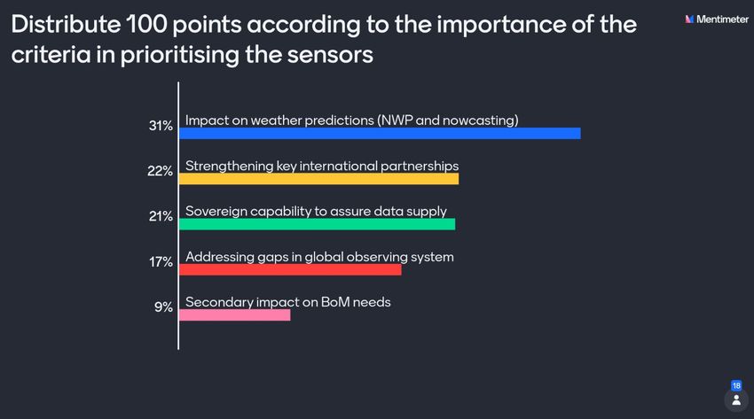
ANCDF: Bureau of Meteorology
                                                                      15/10/2021
                                   Pre Phase A Mission Study Report

                                  Page intentionally left blank

Prepared by UNSW Canberra Space                                         Page 2 of 80
ANCDF: Bureau of Meteorology
                                                                                       15/10/2021
                                     Pre Phase A Mission Study Report

1 Executive brief

This report presents the findings of a Pre-Phase A study which was conducted by the Australian
National Concurrent Design Facility (ANCDF) and involved a total of 27 personnel from the
Australian Bureau of Meteorology (The Bureau), UNSW Canberra Space, the Australian Space
Agency, and Geoscience Australia.

   •   This study was conducted during four two-hour CDF sessions over the course of three weeks
       in March and April 2021.

   •   The study examined the feasibility of developing dedicated satellite missions to fulfil future
       Bureau operational needs. Three meteorological instruments with the potential to meet a key
       set of the Bureau's future needs for satellite data were selected from a set of ten possible
       instruments. For each of these the Bureau provided a rough outline of the performance
       specifications (e.g., accuracy, spatial resolution, frequency bands). The instruments selected
       for analysis in the study are;

          o   a lightning sensor to support severe storm forecasts and warnings and climate
              studies,

          o   a synthetic aperture radar (SAR) for use over the Antarctic to support ice monitoring
              and,

          o   a hyperspectral microwave sounder to provide atmospheric temperature and water
              vapour information for assimilation into numerical weather prediction (NWP) models.

   •   For each instrument a follow-up 30-minute requirements refinement meeting was held after
       Session 4 of the CDF study.

   •   Australia has a nascent space industry. The pathway to trusted and reliable operational
       sensors will require development of pathfinder or demonstration payloads as a first step. This
       study focused on sensor configurations that can be developed over the next 5-10 years, by
       primarily Australian industry, with mentoring from international partners where needed.

   •   The study provided an:

          o   assessment of the current global technical capability and cost estimates for each of
              the three instruments,

          o   estimation of the capacity of Australian industry to deliver instruments with similar
              capability as those currently deployed and/or pathfinder missions that would provide
              reduced capability but useful data to the Bureau within a 5-year time window and,

          o   recommendation to proceed to a Phase A study to develop baseline conceptual
              designs for a pathfinder version of each mission.

   •   This study does not consider technical solutions or Australian technical capability for real
       time data transmission which would include the need for ground station capabilities and
       processing of data, but this capability would be essential for operational missions that support
       the Bureau's forecast and warning services.

   •   This study also presents the results of a survey conducted by Earth Observation Australia
       (EOA) that identifies Australian missions and/or projects that may be considered as
       candidates for a meteorological satellite mission. This study assesses the potential value of
       these missions in supporting weather services.

Prepared by UNSW Canberra Space                                                           Page 3 of 80
ANCDF: Bureau of Meteorology
15/10/2021
Pre Phase A Mission Study Report
2 Contents
1 Executive brief ........................................................................................................................ 3
2 Contents .................................................................................................................................. 4
3 Table of Figures ...................................................................................................................... 6
4 Table of Tables ....................................................................................................................... 7
5 Executive summary ................................................................................................................. 8
6 Study context ........................................................................................................................ 10
7 Acknowledgments ................................................................................................................. 12
8 Study methodology and objectives ....................................................................................... 13
9 Bureau mission options ......................................................................................................... 14
9.1 Option 1 – Real-time vertical Infrared (IR) soundings ....................................................... 14
9.2 Option 2 –Hyperspectral microwave soundings and radiances ........................................ 15
9.3 Option 3 – Real-time weather imaging .............................................................................. 16
9.4 Option 4 – Extended observations of the Antarctic using Synthetic Aperture RADAR (SAR)
17
9.5 Option 5 – Lightning sensor .............................................................................................. 18
9.6 Option 6 – 3D wind-field horizontal component ................................................................. 19
9.7 Option 7 – Precipitation and clouds................................................................................... 19
9.8 Option 8 – Wave height, direction, and period .................................................................. 20
9.9 Option 9 – Day and night capability................................................................................... 20
9.10 Option 10 – Real-time data dissemination of large data volumes from space .................. 21
10 Australian Community Mission Options ................................................................................ 22
11 Mission down-selection ......................................................................................................... 24
12 Mission concepts .................................................................................................................. 26
12.1 Mission concept 1 – Lightning sensor ............................................................................... 26
12.1.1 Objectives and requirements ..................................................................................... 26
12.1.2 Related missions ........................................................................................................ 27
12.1.3 Instrument discussion ................................................................................................ 30
12.1.4 Implementation options .............................................................................................. 32
12.1.5 Cost estimate ............................................................................................................. 32
12.1.6 Open points and questions ........................................................................................ 34
12.2 Mission concept 2 – Extended observations of the Antarctic using Synthetic Aperture
RADAR (SAR) .............................................................................................................................. 35
12.2.1 Objectives and requirements ..................................................................................... 35
12.2.2 Related missions ........................................................................................................ 36
12.2.3 Instrument discussion ................................................................................................ 39
12.2.4 Implementation options .............................................................................................. 40
12.2.5 Cost estimate ............................................................................................................. 40
Prepared by UNSW Canberra Space Page 4 of 80ANCDF: Bureau of Meteorology
15/10/2021
Pre Phase A Mission Study Report
12.2.6 Open points and questions ........................................................................................ 41
12.3 Mission concept 3 –Hyperspectral microwave sounder .................................................... 43
12.3.1 Objectives and requirements ..................................................................................... 43
12.3.2 Related missions ........................................................................................................ 45
12.3.3 Instrument discussion ................................................................................................ 48
12.3.4 Implementation options .............................................................................................. 51
12.3.5 Cost estimate ............................................................................................................. 51
12.3.6 Open points and questions ........................................................................................ 52
12.4 Additional estimated costs for a Pathfinder Cubesat mission ........................................... 52
12.4.1 Spacecraft level AIT ................................................................................................... 53
12.4.2 Environmental qualification ........................................................................................ 53
12.4.3 Operations .................................................................................................................. 53
13 Satellite platforms ................................................................................................................. 55
13.1 Offshore platform providers ............................................................................................... 55
13.2 Australian platform providers ............................................................................................. 56
14 Spacecraft level Australian AIT and qualification infrastructure ............................................ 57
15 Launch segment ................................................................................................................... 58
15.1 Offshore launch service providers ..................................................................................... 58
15.1.1 RocketLab .................................................................................................................. 58
15.1.2 Space Exploration Technologies (SpaceX)................................................................ 58
15.1.3 Antrix .......................................................................................................................... 58
15.1.4 Momentus .................................................................................................................. 58
15.1.5 Spaceflight Industries ................................................................................................. 59
15.2 Australian launch service providers................................................................................... 59
15.2.1 Black Sky Aerospace ................................................................................................. 59
15.2.2 Gilmour Space Technologies ..................................................................................... 59
16 Orbits .................................................................................................................................... 60
17 Ground stations ..................................................................................................................... 62
18 Conclusions and Recommendations .................................................................................... 63
19 List of acronyms and abbreviations ...................................................................................... 65
20 References ............................................................................................................................ 68
21 Appendix A: Study participants ............................................................................................. 69
22 Appendix B: EOA survey results ........................................................................................... 70
23 Appendix C: Bureau personnel survey: Ranking of missions ............................................... 78
Prepared by UNSW Canberra Space Page 5 of 80ANCDF: Bureau of Meteorology
15/10/2021
Pre Phase A Mission Study Report
3 Table of Figures
Figure 1 Study workflow .................................................................................................................. 13
Figure 2 Zenith opacity due to oxygen and water vapour in the microwave frequency range. ........ 48
Figure 3 Radiometer tracking. ......................................................................................................... 49
Figure 4 Rank ordered importance of the Bureau's goals ............................................................... 78
Prepared by UNSW Canberra Space Page 6 of 80ANCDF: Bureau of Meteorology
15/10/2021
Pre Phase A Mission Study Report
4 Table of Tables
Table 1 NASA Project Lifecycle Pre Phase A formulation ............................................................... 10
Table 2 EO Community missions and benefits to meteorology and disaster resilience .................. 22
Table 3 Bureau mission requirements for meteorological instruments ............................................ 24
Table 4 Ranking survey of 10 of the most critical meteorological satellite capabilities used at the
Bureau ........................................................................................................................... 24
Table 5 Lightning sensor requirements summary............................................................................ 26
Table 6 Current lightning sensor performance summary................................................................. 29
Table 7 Lightning sensor cost estimate summary ........................................................................... 34
Table 8 General observation requirements for sea ice concentration and motion measurements
using SAR ..................................................................................................................... 35
Table 9 ICEYE SAR operating parameters ..................................................................................... 37
Table 10 Summary of ICEYE imaging modes ................................................................................. 38
Table 11 SWaP comparison for Sentinel-1, Radarsat-2 and Radarsat-RCM .................................. 38
Table 12 SAR sensor cost estimate summary ................................................................................. 41
Table 13. Requirements for Microwave Sounder ............................................................................ 44
Table 14. LEO CubeSat Microwave Sounding Missions ................................................................. 46
Table 15 Australian organisations with experience in technologies applicable to developing a
microwave sounder ....................................................................................................... 50
Table 16 MW mission cost estimate summary ................................................................................ 52
Table 17 Estimated spacecraft level AIT costs (CubeSat) .............................................................. 53
Table 18 Estimated operations cost (Cubesat)................................................................................ 53
Table 19 Partial list of offshore platform providers .......................................................................... 55
Table 20 Partial list of Australian platform providers ....................................................................... 56
Table 21 Momentus launch service pricing summary...................................................................... 59
Table 22 Spaceflight launch service pricing summary..................................................................... 59
Table 23 Commercial ground station providers ............................................................................... 62
Table 24 Abbreviations and acronyms ............................................................................................ 65
Table 25 List of personnel ............................................................................................................... 69
Table 26 Mission/Instrument ranking and consideration for conceptual design .............................. 79
Prepared by UNSW Canberra Space Page 7 of 80ANCDF: Bureau of Meteorology
15/10/2021
Pre Phase A Mission Study Report
5 Executive summary
The Bureau of Meteorology depends heavily on Earth Observations (EO) from satellites to predict
the weather. Australia does not own or operate EO satellites and relies on foreign owned satellites
for these observations. The Bureau commissioned this study to explore the feasibility of Australian
designed and built meteorological satellites that could meet specific Australian needs for weather
and climate observations.
As set out in the Australian Civil Space Strategy (the Strategy) the Australian Space Agency is
working with partners across Government to develop technology roadmaps for each of the National
Civil Space Priority Areas identified in the Strategy.
Three studies have been conducted by the UNSW ANCDF to inform the development of the roadmap
for Earth Observation from Space. The three studies include: 1) a Pre-Phase A study for the
AquaWatch mission sponsored by the Commonwealth Scientific and Industrial Research
Organisation (CSIRO), 2) a Phase A study for an Australian Satellite Cross-Calibration Radiometer
(SCR) series sponsored by Geoscience Australia (GA) as a potential part of the USGS/NASA (United
States Geological Survey) Sustainable Land Imaging Initiative, and 3) this study commissioned by
the Australian Bureau of Meteorology (the Bureau) to identify key missions/instruments to support
metrological forecasting and disaster monitoring and mitigation.
The objectives of this study were to identify three meteorological instruments from a set of ten
possible instruments, identified by the Bureau, which have the potential to meet not only the Bureau's
future needs for satellite data but to provide a data generation capability to the global meteorological
community. For each of the instruments, the Bureau provided an outline of the performance
specifications (e.g., accuracy, spatial resolution, frequency bands). The instruments are required to
meet one or more of the following criteria:
a) satisfy the Bureau’s NWP (Numerical Weather Prediction) and Nowcasting requirements,
preferably with a focus on disaster resilience;
b) address gaps in the global observing system, as defined by the WMO's (World
Meteorological Organisation) 'Rolling Review of Requirements'
(https://community.wmo.int/rolling-review-requirements-process), and CGMS (Coordination
Group on Meteorological Satellites) High Level Priority Plan (https://www.cgms-
info.org/documents/CGMS_HIGH_LEVEL_PRIORITY_PLAN.pdf);
c) strengthen key partnerships with international satellite data providers, to ensure ongoing
access to critical satellite data streams;
d) data assurance to support critical services by building a sovereign satellite industry capability;
e) have a secondary impact on the Bureau’s data needs and business functions.
The Bureau selected ten possible instruments for consideration and presented an overview of each
mission during the first CDF session. The instruments were discussed in detail among the study
team, Bureau scientists and stakeholders. A poll was then conducted where the Bureau’s personnel
(Table 25) ranked, in order of importance, the major requirements that each sensor must achieve.
The ten instrument options were then evaluated in terms of their capability to fulfil these requirements
as well as their importance in providing modalities to enhance the working arrangements between
the Bureau and international meteorological agencies/organisations.
This study does not consider technical solutions or Australian capability for real time data
transmission, but this capability would be essential for operational missions that support the Bureau's
forecast and warning services.
Three instruments were selected for analysis in this study:
Prepared by UNSW Canberra Space Page 8 of 80ANCDF: Bureau of Meteorology
15/10/2021
Pre Phase A Mission Study Report
• a lightning sensor to support severe storm forecasts and warnings and climate studies,
• a SAR instrument for ice monitoring, and
• a hyperspectral microwave sounder for atmospheric temperature and humidity profiling.
An analysis was performed by the UNSW team to investigate the feasibility of developing such
sensors in Australia based on the technical, programmatic, and industry capacity as well as cost
implications by comparison with the current and planned capabilities pursued by international space
agencies and the wider global space industry.
Based on the NASA EO Instrument Cost Model and the Bureau's preliminary requirements, the
rough order of magnitude costs are AUD $86 million for a 100kg lightning payload, AUD $13 million
for a 4kg microwave pathfinder, and AUD $17 million for an 85kg SAR pathfinder. Costs for the
platform, testing, launch and operation are not included in these estimates.
Most of the satellite data currently used by the Bureau are from operational missions with continuity.
With the Australian space industry in an early developmental phase, there is effort required to build
the infrastructure and skills necessary to manufacture any of the identified missions to a fully
operational capacity within the next 5 years. The pathway to operational, reliable and trusted
missions is through the development of demonstration or pathfinder missions.
Australian industry developed pathfinder missions could include sovereign instrument designs,
spacecraft subsystems and data processing capabilities which could serve as a pathway to longer-
term operational systems as the industry matures, whilst simultaneously providing improved data
products to the Bureau and its partners in the short-term. In doing so, it would build Australian space
heritage and increase the Technology Readiness Levels (TRL) of the Australian space sector. The
result would be an increase of skills in Australia across the supply chain and within all related sectors.
For each mission it was concluded that a Phase A investigation is warranted. Outcomes from these
studies could be a further down-selection to consider development of one or two missions, a refined
profile for each mission, a restructuring of project goals, investment in key domestic technology areas
and establishing working relationships with international partners (both industrial and governmental)
for mission development.
This study also presents the results of a survey conducted by Earth Observation Australia (EOA)
that identifies Australian missions and/or projects that may be considered as candidates for a
meteorological satellite mission. This study assesses the potential value of these missions in
supporting weather services.
Prepared by UNSW Canberra Space Page 9 of 80ANCDF: Bureau of Meteorology
15/10/2021
Pre Phase A Mission Study Report
6 Study context
The Bureau has been a substantial user of Earth observations from space for several decades, and
this continues to grow at a significant pace. The Bureau currently assimilates data from over 30
satellites1 into weather, ocean and hydrology prediction and visualisation systems every day. This is
crucial for the provision of weather forecasts and warnings across Australia and beyond, to support
national commitments for safety and security specified in the Meteorology Act 1955.
Australia does not own or operate Earth Observation (EO) satellites and relies on foreign-owned
satellites for these observations. Developing a sovereign Australian EO satellite capability would
assist in guaranteeing long-term access to meteorological observations from space and reduce the
risk of losing free and open access to critical satellite data streams required for weather forecasting.
Over the next decade, volumes of data used by the Bureau are predicted to increase by a factor of
30 – 50 with the development of next generation meteorological sensors that more thoroughly
measure phenomena in the atmosphere, on land and at the sea surface. Observations from satellites
have a large impact on forecast accuracy, particularly in the Southern Hemisphere where the number
of observations from surface stations and radiosondes are much reduced and unevenly distributed.
The value of satellite observations to the Bureau and the broader economy was described in the
Deloitte Economic study into an Australian continuous launch small satellite program for Earth
observation2. It found that the Bureau’s services, which are largely underpinned by satellite data,
contribute a significant proportion of the direct value added by the EO sector.
The Bureau’s Research and Development Plan 2020-2030 articulates a number of initiatives within
its 10-year vision for improving weather forecasts, including “substantial increases in data
assimilated, and much greater variety of traditional and non-traditional data sources used in our
systems”. This includes using observations from conventional large science-grade satellite missions
and new sources like SmallSats.
This Pre-Phase A study is concerned with identifying possible missions so that the Bureau can
improve its weather forecasting, nowcasting and environmental monitoring objectives.
In general, the study has used the NASA project lifecycle approach for conducting a Pre-Phase A
space mission study. Table 1 provides a summary of the formulation undertaken in this study3.
Table 1 NASA Project Lifecycle Pre Phase A formulation
Pre-Phase A Definition Concept Studies
To produce a broad spectrum of ideas and alternatives for missions from which
Purpose
new programs/projects can be selected.
A study or proposal team analyses a broad range of mission concepts that can
fall within technical, cost, and schedule constraints and that contribute to
Approach program and Mission Directorate goals and objectives. Pre-Phase A effort could
include focused examinations on high-risk or high technology development
areas.
1
http://www.bom.gov.au/australia/charts/bulletins/nmoc_bulletin.shtml
2
https://www2.deloitte.com/au/en/pages/economics/articles/economics-earth-observation.html
3
https://www.nasa.gov/seh/3-project-life-cycle
Prepared by UNSW Canberra Space Page 10 of 80ANCDF: Bureau of Meteorology
15/10/2021
Pre Phase A Mission Study Report
Together the study team, customers, and other potential stakeholders, help the
team to identify promising mission concept(s). The key stakeholders (including
Typical outcomes the customer) are identified and expectations for the project are gathered from
them. If feasible concepts can be found, one or more may be selected to go into
Phase A for further development.
Prepared by UNSW Canberra Space Page 11 of 80ANCDF: Bureau of Meteorology
15/10/2021
Pre Phase A Mission Study Report
7 Acknowledgments
This study was undertaken by the following study participants:
A full list of study participants can be found in Appendix A: Study participants.
Prepared by UNSW Canberra Space Page 12 of 80ANCDF: Bureau of Meteorology
15/10/2021
Pre Phase A Mission Study Report
8 Study methodology and objectives
The study was conducted during four CDF sessions and in outside work conducted by UNSW
Canberra Space engineering personnel over a period depicted in Figure 1. Sessions 1 and 2 were
geared to defining the Bureau’s top ten meteorological space missions and down-selecting to three
key missions for further investigation. Sessions 3 and 4 presented the findings of the study team,
further interaction with the Bureau’s scientists and data users and a discussion of results and
conclusions.
Figure 1 Study workflow
The following methodology was used to fulfil the study objectives for each of the three missions;
a) assess the current global capability and technical feasibility of each instrument type,
b) construct a set of preliminary mission and performance requirements for each instrument,
c) assess the technical and programmatic feasibility to develop each instrument,
d) identify constraints, limitations, technology gaps or non-feasible elements to develop each
instrument type within the context of the current state of the Australian space industry,
e) define a preliminary development approach considering areas of mission risk and,
f) determine the features, size and cost of these missions which can include scoping of
international partnership options,
g) recommend those missions which have sufficient technical feasibility to merit further
investigation in Phase A study where an initial instrument design baseline and mission
concept, as well as a codified system-level requirements document, needed system
technology developments, and program/project technical management plans would be
created.4
Australia has a nascent space industry, and so the pathway to trusted and reliable operational
sensors will require development of pathfinder or demonstration payloads as a first step. This study
focused on sensor configurations that can be developed over the next 5-10 years, by primarily
Australian industry, with mentoring from international partners where needed.
4
Australian Government Commonwealth Contract-Services, ID 225-3030-21 (2021)
Prepared by UNSW Canberra Space Page 13 of 80ANCDF: Bureau of Meteorology
15/10/2021
Pre Phase A Mission Study Report
9 Bureau mission options
The Bureau presented an overview of ten meteorological satellite capabilities that if developed would
provide a sovereign contribution to the meteorological data used by the Bureau and international
partners. This section presents a summary of each of the capabilities which formed the basis for a
down-selection exercise to explore in greater detail the feasibility of developing the top three
missions deemed most important to the Bureau.
9.1 Option 1 – Real-time vertical Infrared (IR) soundings
Operational requirement: IR sounders are sensitive to temperature and moisture profiles at
different heights in the atmosphere. Current hyperspectral instruments deliver temperature
information with a vertical resolution of around 1 K per km, humidity information with a resolution of
10% per km, and an Instantaneous Field of View (IFOV) of around 12 km. Coupled with advances
in computing and processing, these observations have been one of the greatest contributions from
meteorological satellites to weather forecasting. They have shown consistently that they improve
forecast accuracy and consequently assist in the early prediction of severe weather events. At the
Bureau, IR soundings from the IASI instrument have the greatest impact on the Bureau’s Numerical
Weather Prediction (NWP) system, and account for 20% of the impact on forecast accuracy on the
Bureau’s global scale model.
Over the next decade the Bureau’s NWP system will continue to improve, with expected
improvement in spatial resolutions and better modelling of error correlations. The global model will
approach convection-resolving resolution and regional models will approach sub kilometre
resolutions. Currently, data is thinned to reduce error correlations between measurements, but in
the future this will be overcome by directly accounting for these correlations, using better forward
operators and using observations with smaller footprints. These improvements, together with
expected innovations in computing and assimilation techniques will allow the Bureau to assimilate
greater volumes of satellite observations which will result in improvements to the Bureau's forecasts5.
IR soundings used at the Bureau are mostly from satellites in Low Earth Orbit (LEO). Data is received
over the internet and from the Bureau’s ground stations. Locally received data is delivered within 20
minutes of the observation time, to meet the Bureau’s low latency requirements for rapid update city-
scale modelling. The Bureau does not currently have access to hyperspectral IR sounding
observations from geostationary orbit. Such observations could be of great benefit to the small
domain, high resolution weather models over the most populated regions of Australia, as they would
provide more frequent observations at lower latency, creating more opportunities for cloud-free
observations. The China Meteorological Administration (CMA) operate the GIIRS instrument over
the China region, and EUMETSAT will launch a hyperspectral IR sounder on their Meteosat Third
Generation (MTG) mission in 2023.
Similar operational sensor: IASI, CrIS
Future hyperspectral sounders: IASI-NG, MTG-IRS
Similar CubeSat: MISTIC WINDS
5
http://www.bom.gov.au/inside/Research_and_Development_Plan_2020-2030.pdf
Prepared by UNSW Canberra Space Page 14 of 80ANCDF: Bureau of Meteorology
15/10/2021
Pre Phase A Mission Study Report
Continuity: Ultimately the Bureau requires operational missions with continuity. The Bureau
recognises that the pathway to operational, reliable and trusted missions is through the development
of demonstration or pathfinder missions.
9.2 Option 2 –Hyperspectral microwave soundings and radiances
Operational requirements: Microwave sounders provide global all-weather temperature and
moisture information from the Earth’s surface to top of the atmosphere. The temperature soundings
mainly exploit the oxygen band between 50 and 60 GHz, while the water vapour lines at 22.235 and
183.31 GHz are used for water vapour detection and profile retrieval.
According to the World Meteorological Organisation (WMO), observations from microwave sounders
have been the single most important source of observational information for global NWP over the
past 20 years. The low vertical and horizontal resolution of current microwave sounders compared
with IR sounders makes them more suited to large scale events, however their use has shown
significant impact on weather forecasts, particularly because of their ability to ‘see’ though clouds. In
the Bureau, microwave observations from the AMSU sensor have the third greatest impact on NWP
(after IASI and satellite-derived upper atmosphere winds) and make a significant contribution to the
forecast accuracy on the global model. International weather agencies with more advanced "all-sky"
assimilation find that microwave sounders have the greatest impact on weather forecasts in their
systems.
Microwave radiances are also important for climate monitoring applications due to the heritage of
the temperature records from microwave sensors as far back as 1979. They are important for long-
range climate projections that require consistent and systematic high-quality observations.
The Bureau receives microwave sounding data from the US and Europe via the internet and from
the Bureau’s ground stations in near real time, to meet the low latency requirements of NWP.
SmallSat constellations of microwave sensors offer opportunities as a complementary data type to
the main missions in early-morning, mid-morning and mid-afternoon LEO orbit. The ability to launch
larger numbers of these smaller and cheaper sensors means that they have the potential to fill spatial
and temporal gaps in global coverage with higher spatial resolution.
The Bureau is interested in exploring the feasibility of a hyperspectral instrument of ~100 channels,
allowing it to better depict the temperature and moisture fields in the vertical. Combined with an
appropriate antenna, it will also importantly provide critical all-weather sounding data around and
over Australia at a resolution appropriate to current operational numerical weather prediction models.
This high resolution observational data is anticipated to improve numerical analysis, for example in
the case of severe weather and to provide an improved basis for subsequent forecasts. More
sophisticated use of water-vapour sensitive channels is expected to have a high impact on
precipitation forecasting, and imagery from microwave instruments can be generated for use in
extreme weather nowcasting.
Similar operational sensors:
• AMSU-A on the NOAA and Metop satellites, provide only temperature soundings.
• MHS on the NOAA and Metop satellites (AMSU-B on older missions) are used together with
AMSU-A to provide humidity soundings.
• ATMS on the SNPP and JPSS satellites, provides both temperature and humidity soundings.
Prepared by UNSW Canberra Space Page 15 of 80ANCDF: Bureau of Meteorology
15/10/2021
Pre Phase A Mission Study Report
• MWHS-2 and MWTS –2 on China’s FY-3, separately provide humidity and temperature
soundings.
• The Metop-Second Generation Microwave Sounder, will be launched by EUMETSAT in
2024. Compared with AMSU-A and MHS it will have two additional temperature channels
and three humidity sounding channels.
Similar CubeSats :
• TEMPEST-D, measures water vapour in five channels from 89 to 182 GHz.
• TROPICS, provides temperature profiles in 7 channels near the 118.75 GHz oxygen
absorption line, water vapour profiles using 3 channels near the 183 GHz water vapour
absorption line, imagery in a single channel near 90 GHz for precipitation measurements,
and a single channel at 206 GHz for cloud ice measurements.
• IOD GEMS, 3D temperature and moisture atmospheric profiles. Follow-on mission is GEM-
STORM, with 48 low-earth orbiting 6U passive microwave CubeSat satellites with sounding
and imaging channels.
Continuity: Ultimately the Bureau requires operational missions with continuity. The Bureau
recognises that the pathway to operational, reliable and trusted missions is through the development
of demonstration or pathfinder missions.
9.3 Option 3 – Real-time weather imaging
Operational requirements: The Bureau relies on real time, high temporal frequency, visible and
infrared satellite observations to support operational weather services including for:
• Volcanic ash – for warnings and alerts for the aviation industry.
• Tropical cyclones – for monitoring the formation and track of cyclones.
• Bushfires – for hotspot detection, monitoring of smoke and wind changes.
• Solar insolation – used to understand how much sunshine is available to fuel solar cells, a
variable and increasing part of Australia’s energy mix.
• General situational awareness – for monitoring the development, position, moving direction
and speed of high impact weather events such as thunderstorms.
The Bureau’s needs for real time weather imaging are currently met by JMA’s Himawari-8 satellite,
located at 140.7 deg E, and also Korea's Geo-Kompsat-2A. Since the launch of Himawari-8 in 2015,
the Bureau has benefited from full disk imagery, every 10 minutes, with a latency of around 7
minutes. In addition to the routine 10-minute images, the Bureau also has access to rapid scan data
every 2.5 minutes (from Himawari) and every 2 minutes from Korea’s satellite by request. The rapid
scan imagery is valuable for fast moving high impact events such as volcanic ash, tropical cyclones
and bushfires, and was used during the Black Summer fires in 2019/20.
There are currently no sounder or lightning observations from geostationary orbit over Australia,
except for China’s FY-4 satellites which provide lightning data over parts of Western Australia for
part of the year.
Similar sensors/ missions:
• Himawari-8/9, AHI (Japan)
Prepared by UNSW Canberra Space Page 16 of 80ANCDF: Bureau of Meteorology
15/10/2021
Pre Phase A Mission Study Report
• GeoKompsat-2A, AMI (South Korea)
• FY-4B, AGRI (China)
• GOES-16, -17, ABI (US)
Continuity: The Bureau is reliant on international agencies (JMA, KMA and CMA) for geostationary
satellite coverage over the Australian region.
9.4 Option 4 – Extended observations of the Antarctic using Synthetic Aperture
RADAR (SAR)
Operational requirement: High resolution coverage of the Antarctic sea ice zone is needed for
monitoring of near-real-time operations and for use in numerical weather prediction models.
Sea ice can threaten marine operations and present a hazard for ocean vessels and installations.
The Bureau’s ice monitoring service delivers a daily sea-ice edge service and weekly ice bulletin for
mariners, which requires routine near real time SAR observations for measuring and inferring ice
parameters like surface roughness, ice type, concentration, and drift speed.
The Bureau is moving away from weather and seasonal models that retain a static sea ice through
the modelling timescale. The new generation of models will simulate earth processes through fully
coupled systems that include the modelling of sea ice – on both a global scale and higher resolution
regional Antarctic models. It is expected that such models will not only benefit regional Antarctic
forecasting but will also provide an increase in performance over mid and lower latitudes, including
Australia. Observations over the Antarctic sea ice zone are sparse and mostly lacking. Satellite data
are also more difficult to interpret over this region due to, for example, little optical contrast between
the surface and atmosphere (Brunet et al., 2015). SAR observations are required to provide initial
conditions for the models.
L and C band SAR are complementary and the preferred technologies, however X-band SAR is also
useful. The Bureau currently relies on the two Sentinel-1 missions to meet operational needs.
Together these satellites provide coverage of the Antarctic region every three to five days. To meet
operational needs, daily SAR observations would be ideal. When there are gaps in coverage the
Bureau supplements these observations with commercial SAR data from Radarsat-2 and TerraSAR-
X, as well as visible imagery from Landsat, Sentinel-2/3 and MODIS however these are less useful
as there are few cloud-free days per week. Passive microwave radiometers such as SSMI-S and
AMSR-2 are also useful as a backup.
SAR data is also useful for detecting crevasses and sastrugi, which are hazards for aircraft landing
in the Antarctic.
An Australian SAR mission could provide a secondary benefit of on-demand imaging of the
continental surface, providing observations useful in soil moisture analysis.
Orbit options: elliptical orbit or constellation of LEOs
Similar sensors/ missions:
• Sentinel 1A (C Band)
• Sentinel 1B (C Band)
• Radarsat-2 (C band)
• RCM-1 (C-band)
• ALOS PALSAR-2 (L band)
Prepared by UNSW Canberra Space Page 17 of 80ANCDF: Bureau of Meteorology
15/10/2021
Pre Phase A Mission Study Report
• ICEYE (X band)
• COSMO SkyMed (X band)
• ROSE-L (L band - planned for 2028)
• NI-SAR (L Band – planned for 2022)
• ALOS 4 (L-band – planned for 2022)
Continuity: The Bureau requires operational missions with continuity. The Bureau recognises that
the pathway to operational, reliable, and trusted missions is through the development of
demonstration or pathfinder missions.
9.5 Option 5 – Lightning sensor
Operational requirement: It is estimated that there are 5–10 deaths per year from lightning strikes
in Australia, and more than 100 serious injuries. Lightning also ignites bushfires, causes damage to
electrical infrastructure and the storms associated with lightning also cause damage.
At the Bureau, lightning data is used in a number of applications. Real time lightning observations
(intra cloud and cloud-to-ground) are critical for monitoring the formation, development, tracking and
classification of thunderstorms, and can serve as a very clear indicator of the strength and extent of
storm cells. Monitoring the total flash rates and the rate changes makes it possible to identify lightning
cells with the potential to produce severe weather.
Lightning data are also used to better understand climate variability. Lightning is one of the Global
Climate Observing System’s (GCOS) list of Essential Climate Variables (ECVs), required to
understand and predict the evolution of climate.
The Bureau has developed automated procedures for thunderstorm cell tracking and monitoring
lightning strike density which are used by forecasters to diagnose, forecast and warn of
thunderstorms more accurately and efficiently. These help the Bureau improve safety for the
Australian community and for stakeholders in sectors including aviation and defence. Currently the
Bureau uses in-situ lightning observations from commercial companies to support these services.
Satellite based lightning observations provide an opportunity for a different but complementary
dataset for the Bureau’s forecasters. The Bureau does not currently have access to satellite-based
lightning observations for the Australian region, though the China Meteorological Agency (CMA)
provides data from their demonstrator FY-4A mission for parts of Western Australia for some of the
year. Satellite based lightning is capable of detecting total lightning activity during both day and night,
over land and sea, potentially filling in data gaps where ground-based lightning detection networks
offer low detection resolution. It could be useful for tropical cyclone modelling away from the land
surface, and could provide support to small Pacific nations.
The Coordination Group on Meteorological Satellites (CGMS, 2021) recommends the advancement
of new generation of geostationary satellites, including those with advanced lightning mapping. Such
a mission could potentially be hosted on an international satellite, providing opportunities for
partnership.
Similar sensors/missions:
• GLM (GOES-16, 17) - US region coverage.
Prepared by UNSW Canberra Space Page 18 of 80ANCDF: Bureau of Meteorology
15/10/2021
Pre Phase A Mission Study Report
• LMI (FY-4 series) - limited Australian region coverage
• LIS (ISS)
• LM (Electro M N1) - planned for 2025
Orbit options: Geostationary orbit required to meet the Bureau's requirements for continuous real-
time observations.
9.6 Option 6 – 3D wind-field horizontal component
Operational requirement: Wind observations at all levels of the atmosphere are one of the key
elements required for global NWP. Wind profiles are listed as the highest priority critical atmospheric
variable that is not adequately measured by current or planned observing systems according to the
World Meteorological Organisation (WMO) Rolling Review of Requirements (WMO, 2018).
Observations from in-situ networks such as radiosondes, wind profilers and radars provide high
quality but poor coverage of wind speed and direction, whereas satellite observations such as those
derived from geostationary satellites and scatterometers provide good global coverage but limited
vertical coverage. Despite the limitations, satellite derived upper-atmosphere winds have an
extremely high impact on forecast accuracy.
Satellite based Doppler wind lidar technology is being developed to provide 3D winds of acceptable
coverage and vertical resolution, but thick cloud will provide limitations. Satellite Doppler wind
LIDAR has the potential to provide a breakthrough in tropical wind profiling. The very small footprint
of the high frequency LIDAR gives wind measurements in scattered cloud conditions. Preliminary
impact studies of the Aeolus instrument, the first satellite-based Doppler Wind LIDAR, have shown
significant positive impact in weather forecasts, particularly on tropical winds (Rennie and Isaksen,
2020).
Similar sensors/missions:
• Aeolus
9.7 Option 7 – Precipitation and clouds
Operational requirement: The Bureau operates a network of rain gauges and weather radars in
order to meet its requirements for real time precipitation observations. These in-situ observations
are of high quality but there are gaps in spatial coverage, particularly over oceans, and these
networks only provide information near and at the Earth’s surface.
Passive microwave and infrared sounders are sensitive to cloud and precipitation and can be used
to provide information on these quantities to NWP, particularly with "all-sky" assimilation systems.
In the near future the Bureau will assimilate cloud information derived from Himawari-8 radiances
into the Bureau's city-scale models and the National Analysis System (NAS). In the future satellite
observations from EarthCARE will be investigated.
Active sensors such as lidar and radar provide more direct information, however there are not many
missions with these types of capabilities, so the observations are temporally sparse with respect to
the typical scales of weather phenomena. Different frequencies, antenna types and transceiver
technologies are used, however the main frequencies used are the Ku, Ka, and W bands.
Space-based cloud and precipitation radars enhance the ability to monitor and study cloud and
precipitation processes on a global scale. Climatology of global precipitation observations are used
Prepared by UNSW Canberra Space Page 19 of 80ANCDF: Bureau of Meteorology
15/10/2021
Pre Phase A Mission Study Report
to identify shifts in precipitation and to assess drought and other risks to communities and the
environment. Real time observations are used in nowcasting to monitor and provide forecasters with
guidance on floods and other high impact weather events. Cloud observations have also been used
in global NWP (Fielding and Janiskova, 2020; Janiskova and Fielding, 2020) where they have
demonstrated positive impact on forecast accuracy. Products from GMI and CloudSat are used
extensively in model validation and verification.
Similar sensors/missions:
• TRMM (1997-2015)
• CloudSat (2006 – 2020)
• RainCube (2018 – 2020)
• GPM (2014 – present)
• EarthCARE (2022 – future)
9.8 Option 8 – Wave height, direction, and period
Operational requirement: Altimeter data are essential for the Bureau's ocean model and for ocean
forecasting. The Bureau operates a global ocean forecasting system with high horizontal resolution
around the Australian region and coarser resolution outside the Australian region. The system can
resolve mesoscale eddies and major current systems to high vertical resolution to resolve the mixed
layer and thermocline. The system provides daily analyses and forecasts of ocean temperature,
salinity, sea level and currents out to 7 days lead time. Key users of the Bureau's ocean services
include the Australian Defence Force and the fisheries industry.
The Bureau's ocean model uses various satellite and in-situ observations, including data from four
altimeter instruments (Cryosat2, Jason-3, SARAL, Sentinel 3A). The average accepted number of
altimetry observations from these four satellites is currently around 200,000 per day. Altimeters
provide information on sea level, ocean topography, significant wave height, near surface wind
speed. CGMS reports that ocean altimetry currently has poor coverage, no afternoon orbit and poor
polar coverage. There is a need for more large-swath instruments, to increase geographical altimetry
coverage, for example through wide-swath altimetry.
Similar missions:
• Cryosat2
• Jason
• SARAL
• Sentinel 3A
• SWOT (to be launched in 2022) will provide much improved resolution altimetry compared
with current technology.
9.9 Option 9 – Day and night capability
Operational requirement: The Bureau currently uses data from the Visible Infrared Imaging
Radiometer Suite (VIIRS) instrument onboard the Suomi National Polar Partnership (NPP) mission.
The VIIRS day/night band in the spectral range of 0.5–0.9 μm provides visible imagery at night,
mainly from illumination from the moon.
Prepared by UNSW Canberra Space Page 20 of 80ANCDF: Bureau of Meteorology
15/10/2021
Pre Phase A Mission Study Report
The Day/Night band can be used in nowcasting applications to track fog at night, for monitoring warm
low-level cloud, and to track air quality and visibility hazards such as smoke and dust at night.
Himawari-8 does not have a day/night band, but the Bureau uses an RGB product (referred to as
the Night Microphysics RGB product) derived from three Himawari-8 channels. This product is used
for fog and low cloud detection at night, providing forecasters with information on the atmosphere
24/7.
Current sensors/missions:
• VIIRS (SNPP and NOAA-20)
• FY-3E (MERSI-LL)
9.10 Option 10 – Real-time data dissemination of large data volumes from space
Operational requirement: Over 95% of observations used in the Bureau’s weather models are from
satellites. Satellite data contributes to 70% of the forecast error reduction (on the Bureau’s 24 hour
global domain), and 61% over the Australian verification domain. In the Bureau, the forecast impact
of satellite data is more than double the impact of convectional in-situ data. It is critical that satellite
data are received in near real time, to ensure that forecasters receive high quality model outputs.
The WMO defines the latency requirements of global NWP and high-resolution NWP for atmospheric
temperature, humidity profiles and wind vector at sea surface as 30 minutes. In practice however
the latency of these observations is longer than the recommended 30 mins. There are a number of
factors that can affect the latency of satellite data, including transmission speed to the ground station,
the number of ground stations, the number of satellites that can be observed at a ground station,
and data pre-processing.
To meet NWP requirements for low latency satellite observations, the Bureau operates a network of
ground stations that receive data from several LEO satellites. The Bureau is also a member of the
Direct Broadcast Network (DBNet), a worldwide network of local, Direct Broadcast receiving stations
that enable the delivery of satellite data to the global user community. The use of these systems
maximises the benefits of LEO satellite data to NWP.
It is essential that any operational satellite missions developed for meteorological applications have
the capability to transmit data in near real time, preferably with a latency ofANCDF: Bureau of Meteorology
15/10/2021
Pre Phase A Mission Study Report
10 Australian Community Mission Options
In addition to the mission options presented by the Bureau, the EO community was invited to submit
details on any current Australian missions and/or projects that may be considered as candidates for
a meteorological satellite mission that could support high impact weather events such as bushfires
and severe storms, or sensors that support numerical weather prediction. The survey was conducted
by Earth Observation Australia (EOA).
The EO community proposals cover a wide range of technologies and missions which would be
valuable for weather forecasting. A detailed list of all the missions is presented in Appendix B, and
a summary of the capabilities and their potential benefits for meteorology and mitigating the impacts
of high impact weather events is provided below.
Table 2 EO Community missions and benefits to meteorology and disaster resilience
Missions How the mission capabilities would benefit meteorology and disaster
resilience
AIRES Nighthawk High spatial resolution imagery is useful for high resolution weather models
for urban areas, fuel load monitoring in support of bushfires, bushfire
Satellite Cross-
detection, and sea-ice monitoring (when cloud-free).
Calibration
Radiometers (SCR) High resolution imagery are also used for land use monitoring, agriculture,
resource exploration, and water security. Satellites with Infrared (IR)
CSIROSat-1
capability can measure forest fuel load and vegetation moisture levels,
Skyris which are essential datasets for bushfire management.
SmartSat CRC / Uni
of Adelaide SMIRF
OzFuel
WildfireSat
Uni of Newcastle GNSS related observations are becoming increasingly important for both
CubeSat GPS terrestrial weather and space weather applications. GNSS Radio
meteorology Occultation and GNSS to ground observations are assimilated
experiment operationally into the Bureau's NWP system and have significant impact
on improving forecast accuracy. GNSS reflectometry is a new technique
ASCER GNSS
that has the potential to provide useful surface information relevant to
Skykraft GNSS RO meteorological and disaster resilience, including for estimating soil
SPIRE GSMM moisture, flood/wetlands mapping, ocean surface winds, and sea ice
height.
NovaSAR-1 SAR observations are used by the Bureau for ice monitoring, estimating
wind speeds during tropical cyclone events, and monitoring flood extent.
Although there are increasing numbers of SAR satellites in orbit, temporal
coverage is still limited.
University of Gamma ray technology offers a potentially exciting new capability for
Melbourne SpIRIT improving our understanding of lightning, including how lightning is
initiated, and the lifecycle of thunderstorms.
ANU CHICO Hyperspectral observations for coastal regions and oceans at high
(Cubesat resolution (~30m) would provide valuable information for monitoring
Prepared by UNSW Canberra Space Page 22 of 80You can also read