Flood based farming systems in Africa
←
→
Page content transcription
If your browser does not render page correctly, please read the page content below
Over view Paper S pa t e I r r i ga tio n
5
Flood based farming
  systems in Africa
O ve r v i ew Pa p e r # 5
                             Table of Content

                             1. Introduction                                                                        1
                             2. Flood based farming systems; definition and categories                              1
                             3. Floodplain agriculture                                                              2
                                      3.1 West Africa                                                               4
                                      3.2 Central Africa                                                            7
                                      3.3 East Africa                                                               7
                                      3.4 Southern Africa                                                           9
                                      3.5 Summarizing: common practices of flood plain agriculture throughout SSA   10
                             4. FBFS in Africa: Spate Irrigation                                                    11
                                      4.1 Spate Irrigation in the Horn of Africa                                    11
                                      4.2 Spate Irrigation in Asia – lessons, best practices and experiences        18
                                      4.3 Best Practices - experiences                                              19
                             5. Depression agriculture – Bas-fonds and dambos                                       21
                             6. Other flood based farming systems; Inundation canals and dug outs                   22
                             7. Overview of livelihood systems                                                      23
                                      7.1 Adapted crop agronomy                                                     23
                                      7.2 Pastoralism in floodplains                                                24
                                      7.3 Other floodplain resources, timber and non-timber products                25
                             8. Fishing and Aquaculture in floodplains                                              25
                                      8.1 Riverine and floodplain fishing                                           27
                                      8.2 Fingerponds                                                               28
                             9. Potential for FBFS development                                                      29
                                      9.1 Agricultural practices                                                    29
                                      9.2 Floodplain water management – skills and practises                        29
                                      9.3 Artificial Flood Releases                                                 30
                                      9.4 Innovative Technologies                                                   30
                                      9.5 Mapping groundwater potential zones in floodplains.                       33
                                      9.6 Upscaling                                                                 34
                             10. Risks and threats for FBFS development                                             34
                                      10.1 Infrastructure development                                               34
                                      10.2 Civil Conflicts                                                          36
                                      10.3 Invasive species                                                         36
                             11. Conclusions                                                                        37
                             References                                                                             39
                             Annex 1: Possible support to wider flood-based farming by Spate Irrigation Network     42
                             Foundation
Table of Figures
Figure 1: Flood recession rice cultivation on a Cambodian floodplain 3
Figure 2: Senegal River Valley 5
Figure 3: Floodplain land use in the Senegal River Valley 5
Figure 4: Traditonal Shadoof 5
Figure 5: Yobe River Catchment 6
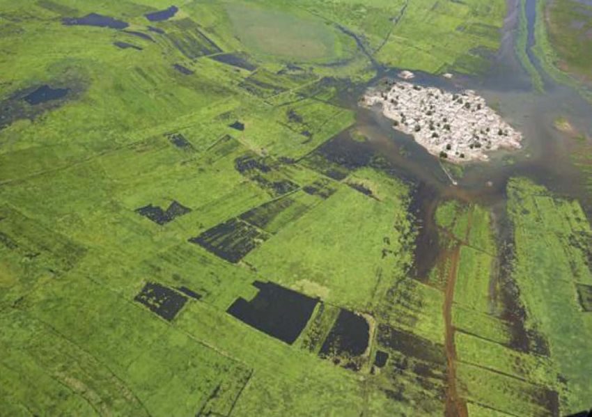
Figure 6: Villages around Mopti, Niger River Inner Delta, Mali from 6
Figure 7: Niger inner delta flood front 7
Figure 8: Types of cultivation at the margins of the Niger Inland Delta( 7
Figure 9: Chari River drainage basin 7
Figure 10: Flood Recession Farming in Lower Omo River Basin 8
Figure 11: Cross-section showing geomorphology, soil and activities on different parts of the floodplain 8
Figure 12: Sudd Floodplain 9
Figure 13: Okavango delta 9
Figure 14: Abandoned bund made to retain water in the Molapo 10
Figure 15: Traditional maintenance of diversion and guide bunds in She’eb scheme 13
Figure 16: Fota intake, silt-laden floodwater, Gash scheme 14
Figure 17: Guide bunds to spread water, sand dunes and depositions impede even spread of 15
floodwater
Figure 18: Stream reservoir built to hold run-off from dry riverbed 16
Figure 19: Distribution Structures in a number of spate schemes in Morocco 17
Figure 20: Regions in tropical Africa where bas-fonds occur 21
Figure 21: Bas-fond in Senegal 21
Figure 22: Initial stages of alluvial dug outs 22
Figure 23: Cattle camp in South Sudan 24
Figure 24: Contour ponds 26
Figure 25: Barrage ponds 26
Figure 26: Paddy ponds made in a flat dambo 26
Figure 27: Tilapia macrochir common in Congo, Upper Zambezi, Kafue and Okavango river systems 27
Figure 28-29: Fish trap in Lake Yirol (left) & fishing with a throw net (right) South Sudan 27
Figure 30: Economically most important fish species in the Inner Niger Delta 28
Figure 31: Fingerpond orientation and cross-section 28
Figure 32-33: Floatiing rice cultivation, Vietnam 29
Flood based farming systems in Africa
Figure 34: Mapping shallow groundwater for Multiple Use Systems 33
Figure 35-36: Prosopis juliflora 36
Figure 37: Geographical distribution of survey respondents 42
Figure 38: Employment sector of the different respondents 42
Figure 39: FBFS occupation by respondents 42
Figure 40: :Largest priority to develop FBFS, according to respondents 42
Figure 41: Prioritization for better use and management of floodplains, according to respondents 43
Figure 42: Suggestions on different fields the Spate Irrigation should work in the future 43
Figure 43: Organizations the Spate Irrigation network should approach 43
O ve r v i ew Pa p e r # 5
                             List of tables

                             Table 1: Indication of total agricultural area per country, and area used for flood recession agriculture   4
                             Table 2: Estimation of the floodplain area in Western Sahel                                                 4
                             Table 3: Cereal crop yields in dryland and Molapo                                                           10
                             Table 4: Potential for spate irrigation development in Kenya                                                16
                             Table 5: Irrigable lands in Morocco                                                                         17
                             Table 6: Irrigated area under Spate Irrigation in Morroco (in Hectares                                      18
                             Table 7: Incurred costs by structure in Spate Irrigation system in Afghanistan                              18
                             Table 5: Common crops and expected yields under the Lashkari System, Afghanistan                            19
                             Table 9: Categories and areas of wetlands in tropical sub-Saharan Africa                                    20
                             Table 10: Different estimates of total wetland extent in Africa                                             20
                             Table 11: Distribution and extent of selected fringing riverine floodplains (including a few rain-fed       20
                             floodplains) in Africa
                             Table 12: Manual drilling techniques                                                                        31
                             Table 13: Potential health impact of large dam projects                                                     35

                             List of Text Boxes

                             Text Box 1: Asian long tradition of flood farming agriculture                                               3
                             Text Box 2: Spate Irrigation Scheme Investments in Ethiopia                                                 12
                             Text Box 3: Social Organization of Eritrean traditional Spate Irrigation Systems                            14
                             Text Box 4: Sub-Saharan wetland and floodplain surface estimations                                          20
                             Text Box 5: Common types of inland floodplain ponds                                                         26
                             Text Box 6: Chinese low cost micro pumpsets                                                                 32
                             Text Box 7:Conclusions from the survey FBFS practitioners                                                   38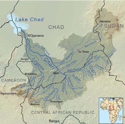
Flood based farming systems in Africa
O ve r v i ew Pa p e r # 5
                             1. Introduction                                             common elsewhere – are little know in SSA.
                                                                                         Another development is that in spite of the high
                                                                                         potential, FBFS are often entirely ignored. It is not
                             Agricultural systems have been traditionally
                                                                                         uncommon that hydropower project or perennial
                             classified in two categories: rain-fed or irrigated.
                                                                                         irrigation project are developed at the detriment
                             This has left a huge gap in the middle, as many
                                                                                         of downstream FBFS, as if they did not exist and
                             farming systems are neither rain-fed or irrigated,
                                                                                         their value is not appreciated.
                             but depend on floods or, for instance, on water
                             logged soil layers.
                                                                                         FBFS are practised throughout different parts
                                                                                         of Africa. This Overview Paper aims to construct
                             This paper deals with the largest group of
                                                                                         an overview, realizing that many systems (for
                             systems that are neither rain-fed nor conventional
                                                                                         instance the inundation canals in Sudan) are
                             irrigation, i.e. flood based farming systems
                                                                                         not documented. The paper is prepared as
                             (FBFS). FBFS depend on flood events that may
                                                                                         part of the activities of the Spate Irrigation
                             vary in duration from a few hours to a period
                                                                                         Network. The Spate Irrigation Network initially
                             of months. The flood event may be regulated
                                                                                         concentrated on the support to one type of FBFS
                             with floods diverted or the rise and recession of
                                                                                         – i.e. spate irrigation - through identifying and
                             floods guided, but in general FBFS to a large
                                                                                         promoting good practice, capacity building and
                             extent adjust to the flood event rather than
                                                                                         the development of programs and policies. It
                             fully control it. FBFS can be combined with the
                                                                                         soon realized that there is a large scope to give
                             use of groundwater that greatly enhances their
                                                                                         systematic support to the wider range of FBFS,
                             productivity.
                                                                                         given the areal extent and the opportunities for
                                                                                         high productive use and the fact that they are
                             FBFS in Africa are amazingly extensive, probably
                                                                                         generally forgotten.
                             close to 25 M ha, as this paper describes, but also
                             in Asia for instance in Bangladesh, Cambodia,
                                                                                         The Overview Note first describes the main
                             India, Myanmar, Nepal, Vietnam,, etc. The much
                                                                                         forms of FBFS (section 2) and then describes
                             higher productivity of FBFS in Asia compared to
                                                                                         their occurrence in different parts of Africa,
                             Africa - related to a more intense management
                                                                                         respectively of  flood plain agriculture (section
                             and multi-functional use - suggests the immense
                                                                                         3),  and other FBFS (section 5). It further identifies
                             potential for rural growth in the FBFS areas in
                                                                                         some of the most promising areas of improvement
                             Africa. What it takes to make the difference are
                                                                                         and a proposal for systematic support (section 6).
                             interventions that will change the landscape yet
                                                                                         Possible risks for FBFS are described (section 6),
                             are relatively low-investment and low skills. One
                                                                                         to finally conclude with a general recommendation
                             has to think of: local water retention structures,
                                                                                         (section 7). A survey was undertaken as to where
                             drainage, the introduction of flood-based
                                                                                         the Spate Irrigation Network could add value: this
                             aquaculture, special varieties and the introduction
                                                                                         is given in Annex 1.
                             of complementary more shallow groundwater
                             wells.
                                                                                         2. Flood based farming systems;
                             In developing FBFS it is important to appreciate            definition and categories
                             the many ecosystem services provided by flood
                             plains, ephemeral rivers and natural depression.            FBFS occur in areas which receive floods on a
                             These flood-dependent areas include valuable                regular, maybe even annual basis. The floods
                             wetland functions (e.g. bird migration, ecosystem           are not harmful but form the basis of productive
                             preservation, aquatic diversity, water quality),            farming systems, be it crop cultivation, livestock
                             environmental (e.g. buffer areas in arid                    grazing or fishing grounds. Flooding events can
                             regions, CO2 sequestration), social (floodplains            be of short duration (as in spate irrigation) or
                             are inhabited by numerous communities) and                  can cover longer periods (in riverine or lake side
                             agricultural (FBFS described in this paper). There          systems). The flooding pattern varies with the lay
                             is a need to take an integrated approach towards            of the land and the discharge from rivers or lakes.
                             the development of the FBFS, including making use           Floods may rise and drain gradually or rapidly.
                             of the agricultural potential, In fact given the size       They may be shallow or deep. Other important
                             of the FBFS in Africa their development constitutes         parameters are the sediment load of the flooding
                             one of the largest potentials for agricultural              rivers and how this is deposited and the soil
                             development in SubSaharan Africa (SSA) – but                conditions of the land. In FBFS soils are alluvial
                             the techniques and approaches – as mentioned                but this contains a range of material from fine

                                                                                     1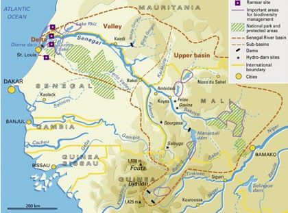
clays to course gravel. This in term determines the                   and increase productivity. Whereas this is common
land use as well as for instance the opportunities                    in Asian FBFS, it is still to be developed in the
to use groundwater.                                                   African context.

Depending on the nature of the flood use and
inundation, FBFS can be classified in different                       3. Floodplain agriculture
categories, namely:
                                                                      Floodplain agriculture is the most common type
• Floodplain agriculture: cultivation of flood                        of FBFS in Sub-Saharan Africa. This type of
  plains, using either receding or rising flood                       agriculture is normally located in floodplains
  water1 or both;                                                     with gentle slope. Water levels rise as a
• Spate Irrigation: diversion of short terms flood                    consequence of intense rainfall3 or rising rivers
  flows from seasonal rivers or “wadis” to field                      (or lakes). The higher water levels inundate the
  by means of small dams, gabions and canals.                         floodplains.  The sediment load in this type of
  This has been a traditional method in Yemen                         flows is high, carrying fine particles to floodplains.
  and Pakistan and North Africa but currently                         Therefore floodplain soils have alluvial deposit
  expanding to eastern Africa2;                                       characteristics (Vertisoils, Fluvisoils, Gleysoils and
• Inundation canals: where land is irrigated by                       Cambisoils) with high content of fertile silt.
  canals fed by temporarily high water levels in
  rivers, this was the system common in ancient                       Flood recession agriculture in most cases consists
  Egypt and still common in parts of Sudan;                           of cropping using the post-indundation residual
• Depression agriculture around temporary                             moisture, left behind once the water levels drops
  wetlands: (such as dambos and bas-fonds)                            again. There are however also areas where crops
  common in humid areas in West Africa,                               are not grown on the receeding flood but on the
  Southern Africa and Central Africa.                                 rising flood. This type of agriculture was matter
                                                                      of study by Harlan & Pasquereau (1969) in the
Apart from managing floods for agricultural                           Niger River, Mali. It was desciribed as crue and
development, other productive activities are                          decrue (from French: crue means rise or flood
carried out in floodplains.                                           while decrue means recession) agriculture. Flood
                                                                      resistant crops, such as rice and sorghum, can be
•    Fisheries, floodplain ponds and finger                           cropped in rising water levels while others, such as
     ponds: on lake basins and floodplains when                       pulses can be cropped in receding4 water levels .
     water levels increase, small ponds are filled                    In some areas this is combined and two cropping
     with water and fish fauna. After the water has                   cycles per flooding season can be developed

                                                                                                                                        Flood based farming systems in Africa
     receded fish get trapped in the ponds and are                    managing flooding patterns.
     grown for human consumption. These systems
     are typical in West Africa and South East                        Floodplain topography and soil typology
     Asia;                                                            (structure and texture) play a key role in flood
•    Flood pastures: pastoralist communities use                      plain agriculture. Floodplain topography is a
     recent flooded areas with pastures for cattle                    factor which affects water distribution. Low
     grazing;                                                         lying areas are prone for flood recession as
•    Timber and bushlands: Forest and bush lands                      moisture is conserved for longer periods of time.
     are common in floodplains, used as a source of                   Alike, the spread of the flood is also driven by
     fuel wood and leave harvesting;                                  topographic conditions. In the same way soil
                                                                      typology determines water retention properties
Time, quantity and recurrence of flood events                         and permeability.
are variable. There is high uncertainty related
to these type systems. Appropriate management
practices on FBFS can lessen such uncertainties

1)   A variation is river bed farming – where not just the flood plains but also land inside the river beds is used. This practice is
     increasingly common in Nepal, Eastern India and Bangladesh where pressure on land resources is intense.
2)   Two variations are: (1) seasonal rivers – flowing for a number of months before falling dry (2) peak flows from unregulated
     perennial rivers that may be diverted for farming and other purposes too.
3)   Floodplain agriculture can occur far away from rainfall precipitation as sometimes flows come from upper parts of
     watersheds.
4)   Rice and sorghum can be cropped in both types of conditions

                                                                 2
O ve r v i ew Pa p e r # 5

                                Text Box 1: Asian long tradition of flood farming agriculture

                                Flood recession agriculture has been practised at least for 1600 years in the Mekong delta (Fox
                                & Ledger Wood 1999). The Funan civilization was established (in what is nowadays Cambodia
                                and Vietnam) in the early centuries A.D. with sophisticated water control systems. Dry season flood
                                recession rice is believed to have sustained economically not only the Funan civilization but the
                                greater Angkor empire (9th to 15th centuries A.D) as well.

                                Traditionally, dry season flood recession rice was cropped either by using natural floods in alluvial
                                plains or by storing flood water using field bunds. Floating rice varieties can grow up to 5 metres
                                stem while flood recession varieties can grow with water levels up to 3 metres. This type of flood
                                recession agriculture requires of water lifting technologies. Traditional water lifting systems are
                                described as water wheels (rohat), bucket swings (snach), and balanced scoops (thleng).

                                Nowadays practises consist of transplanting and broadcasting techniques. Seedbeds are planted
                                in December and transplanted in January. On low lying areas (know as srauv santoung) rice is
                                transplanted whereas in high areas (know as srauv pruos) rice seeds are broadcasted. After
                                transplanting farmers pump water to bunded fields (once every five to seven days during three
                                months) through boengs and trapeangs spreading water through small ditches. In March, when fields
                                are left with no water supply for 2 or 3 weeks, rice is harvested. Thereafter, fields are ploughed
                                at the beginning of the rainy season (June). Flood recession rice yields in the Mekong delta are
                                estimated between 2.5 to 3 tons per hectare. Flood recession varieties are preferred as their yields
                                are higher compared to floating rice. Apart from flood recession agriculture, dry season fishing and
                                fish aquaculture is practised.

                             Figure 1: Flood recession rice cultivation on a Cambodian floodplain (Mekong River Commission 2009)

                                                                                   3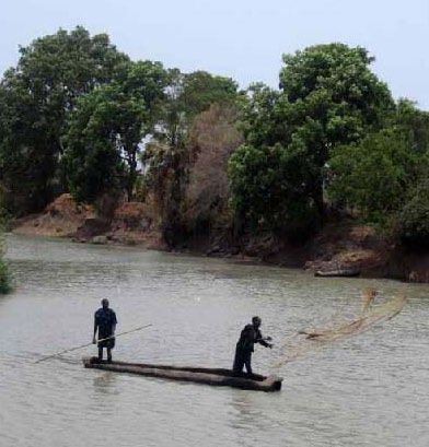
Country                       Total agricultural area Flood recession area               Source
                              (ha)                    (ha)
Senegal                                     9,000,000      150,000 - 200,000             Adams 1992 (1960s)
                                                             15,000 -20,000              Adams 1992 (1970s)
Sierra Leone                                3,000,000                    100             Richards (1985)
Mali                                      40,000,000               2,000,000             Thom & Wells (1987)
                                                                   3,000,000             Deltares
Zambia                                    26,000,000                 900,000             AWM, IWMI (2009)
Botswana                                  26,000,000               6,500,000             Van der Post (2009)
                                                                       6500              FAO (2005)
Somalia                                       430,000                100,000             Basnyat (2007)
Ethiopia                                       35,000
• Lake Tana                                                            6,000             McCarthy, 2010
• Omo Valley
                                                                      11,000             Woodroofe 1996
• Wabi Shebelle River
    Valley                                                             6,800             WWDSA 2003

Table 1: Indication of total agricultural area per country, and area used for flood recession agriculture
As pointed out before, FBFS have high variability               pools. Thereafter embankments and pits are used
making it difficult to estimate total areas.                    to store this water for later use. Table 2 gives
Moreover floodplain agriculture is sparsely                     an estimation of the flood plain area in Western
documented and seldom included in regional or                   Sahel.
global statistics. Table 1 nevertheless depicts a
set of publications including country areas under               3.1.1 Senegal Valley
flood recession agriculture. Below the areas are                The Senegal River valley lies in the lower basin of
explored in more detail. Total agricultural areas               the Senegal River. The total area of the Senegal
are taken from The World Bank (2012)                            Valley5, also known as Futa Tooro, is 1 million
                                                                hectares6 (10,000 km2). The floodplain is 10 to 25
3.1 West Africa                                                 km wide. During the 1960s wet years, between
                                                                150,000 and 200,000 hectares were under
Important floodplain agriculture areas in West                  cultivation. However during the following decade

                                                                                                                      Flood based farming systems in Africa
Africa are the Senegal Valley, the Sokoto Valley                several drought periods diminished the cropped
and Hadijia–Jama’are in Nigeria, the Waanje                     area to about 20,000 hectares.
River in Sierra Leone and the Volta River. Adams
(1992, 1993) documented flood farming systems                   Local Pulaar language has certain terms to
in West Africa. When rivers retreat, water and                  identify different land types and geomorphical
moisture is left in the subsoil or in swamps and                features in the floodplain. The word Hollalde

 Wetland -Floodplains                    Surface area (km2)                      Country
 Sengal                                                                 3,000    Senegal and Mauritania
 Senegal valley                                                         5,000    Senegal and Mauritania
 Niger Inner De;ta                                                     30,000    Mali
 Niger Fringing Floodplains                                             3,000    Nigeria
 Sokoto and Rima Valleys                                                1,000    Nigeria
 Hadejia-Nguru Floodplains                                              4,000    Nigeria
 Logone Floodplain                                                     11,000    Cameroon and Chad
 Lake Chad Floodplain                                                  10,000    Nigeria, Cameroon and Chad
 Total                                                                 67,000
Table 2: Estimation of the floodplain area in Western Sahel (Loth 2004)

5)   This region covers north of Senegal and south of Mauritania. It is also known as Futa Toro.
6)   The Senegal River has a drainage of 270,000 km2, a mean flow of 680 m3/s and an annual discharge of 21.5 km3)

                                                           4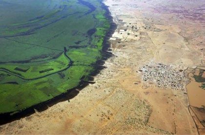
O ve r v i ew Pa p e r # 5

                                                                                                 Figure 3: Floodplain land use in the Senegal River
                                                                                                 Valley (Saarnak 2003)
                             Figure 2: Senegal River Valley (UN Water 2012)
                             refers to deep clay basin soils which retain                        on the riverbanks. Additionally, the wallo system
                             moisture for longer time. These are normally the                    refers to the use of flood receding water to crop
                             most productive areas of the floodplain. Sorghum                    cowpea and sorghum over extended areas.
                             and beans (sorghum as tutor) are cultivated in
                             these types of soils. Elevated soils are referred as                3.1.2 Sokoto Valley, Nigeria
                             fallo and are rainfed cultivated plots (as opposed                  The Sokoto Valley lies in North West Nigeria. The
                             to water receding cropping systems).                                valley is drained by the Sokoto River, a tributary
                                                                                                 of the Niger. Similar flood recession activities are
                             Saarnak (2003) studied water recession                              carried out as in the Senegal River Valley. Rice
                             agriculture in the Senegal River valley. She                        and sorghum are cropped in synchrony with the
                             described cropping of sorghum, beans and melons                     rain and receding water levels. However, during
                             using residual moisture after the flooding period.                  the dry season a second crop is cultivated using
                             Up to three cropping seasons are applied in this                    shallow ground water through Shadoofs8.
                             area combining flood recession and irrigation.
                             The study stressed the importance of topography                     3.1.3 Hadejia-Nguru floodplain, Yobe Basin,
                             and morphology related to water retention and                       Nigeria
                             productivity; which then determines land use                        The Hadejia-Nguru floodplains are located
                             type (flood recession land, irrigated land and                      in north east Nigeria, as part of the Yobe
                             vegetable garden land). High agricultural outputs                   Basin. They are estimated to house nearly 1
                             are obtained compared to low energy inputs,                         million people. Several studies point out three
                             where only labour and land inputs are necessary7.                   distinguished farming seasons: two wet seasons,
                                                                                                 one on rising and one on receding floods, and a
                             During good inundation years, net per hectare                       third dry season farming (Thomas & Adams 1999)
                             incomes from flood recession even equal those                       (FAO 1997).
                             from irrigated agriculture. A major finding of
                             her study identified flood recession outputs of
                             sorghum, beans and melons as an important
                             supplement to household subsistence in terms of
                             food supply. This is acute during January and
                             February when food supply is very limited.

                             Flood recession agriculture is combined with
                             irrigation of rice fields in Mauritania. This
                             combination has proven effective to assure food
                             security. Irrigation was introduced in the 1960s
                             by the government focusing on rice production.
                             Crop diversification and combining flood recession
                             and drainage techniques improve performance
                             of rice and other staple crops. Here under the
                             fallo system maize and cowpea are sown directly                     Figure 4: Traditonal Shadoof (Fraenkel 1986)

                             7)   Guarding against bird attack constitutes the main labour requirement (72%) in sorghum flood recession in this area.
                             8)   Shadoofs were first developed in ancient Egypt as water lifting irrigation tool.

                                                                                            5
(February/March to May/June).
On the other hand, Bongoe is a term referred to
rice transplanted on receding floods (November-
December). Wet season rice farming systems
are named Sokongoe and Kogbati. Sokongoe
is a rainfed rice that is grown on the higher
sandy islands at the back of the river floodplain.
Kogbati are rice floating rice varieties planted
on flooded land (June) and harvested towards
the end of the year. Floating rice varieties are
normally low yielding.
Figure 5: Yobe River Catchment (Wikipedia 3.1.5 Niger River Inland Delta, Mali
2009) The Niger River Inland Delta is located in central
Mali. The southern part of the delta is a vast
alluvial plain subject to annual flooding. In
Regarding flood rise farming, rice is sown when addition, there are a number of temporary lakes
the rainy season starts. When the rice has on both banks of the Niger River. Thom & Wells
reached 12 cm, it can resist floods and water (1987) indicated that over 2 million hectares are
logging conditions. Therefore farmers protect their flooded annually in the Niger Inland Delta; other
plots with bunds to prevent harmful early floods. estimations go up to 3 million hectares (Meijer
Sorghum, cowpeas and wheat are cropped under & Deltares n.d.; Zwarts et al. 2005). The Niger
flood recession. During the dry season, low lying Delta is home to an estimated 1 million people
alluvial soils with remaining moisture are used to and represents one of the major producing areas
crop sweet potatoes and pumpkins. Local Hausa of the country, in terms of livestock, agriculture
language refers to these types of soils (with high and fisheries.
ground water tables) as Fadamas.
An already mentioned study performed by
The Nguru floodplain has high productive Harlan and Pasquereau (1968) studied the Niger
outputs. Traditionally rice and fish products were inland delta in Mali. They found farmers using
exported, and more recently wheat and peppers. floodwater of seasonal floods. Skilled cultivators
Another side-activity in the flood plain occurs with useful practical knowledge of the crops to be
in the dry season. Doum palm leaves (used for planted on wet or drier soils were active in the
elaboration of mats, ropes and baskets) are wetlands adjacent to the river. The sequence of
Flood based farming systems in Africa
collected as raw materials and Baobab leaves crops that performed best from the more upper
are harvested as ingredient in soups and stews. and drier fields, towards the lower and wetter
Fuel wood is also collected from the floodplain as parts of the floodplain were: pearl millet, long-
well as fodder for horse feeding. season durra, mid-season durra, guinea corn and
rice. Figure 8 shows a cross-section of the margins
3.1.4 Waanje River, Sierra Leone of the inland delta and the type of cultivation.
The indigenous rice farming systems in the
Waanje River, Sierra Leone, was researched by
Richards (1985). He identified different flood
based rice cultivation systems. On different
sections of land along the riverbed; depending on
soil moisture, fertility and drainage, different rice
varieties are planted before, during and after the
rainy season.
Local Mende language identifies different land
and rice cropping systems. Seasonal flooded
riverine grasslands are referred as Bati. Similarly,
there is a categorization of two dry season
rice systems, Bongoe and Gbali. Gbali are 3
months duration rice varieties planted on the Figure 6: Villages around Mopti, Niger River
river terraces and moisture-retentive lower-slope Inner Delta, Mali from (source http://stock.
soils using rainfall and residual soil moisture parallelozero.com/)
6O ve r v i ew Pa p e r # 5
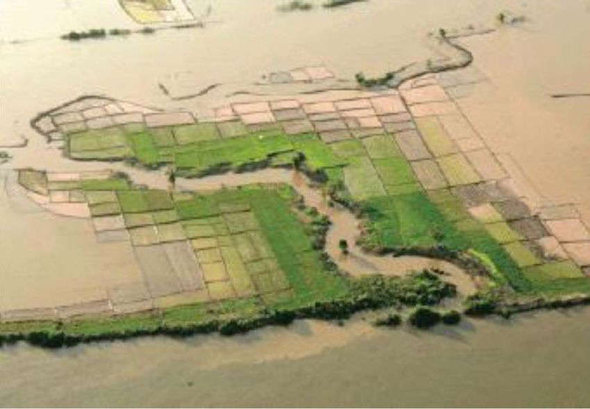
Figure 7: Niger inner delta flood front (source Figure 8: Types of cultivation at the margins of
http://stock.parallelozero.com/) the Niger Inland Delta(Thom & Wells 1987)
Recessional crops that are cultivated are rice, black cotton soils around the lake. Loth (2004)
including the floating rice Oryza glaberrima , also described a dry season sorghum variety
sorghum, millet, maize, cowpeas, peanuts, manioc, that was grown on the Waza Logone floodplain,
sweet potatoes and cotton. There are several surrounding Lake Chad in Cameroon. Another
techniques to grow the rice. Some transplant the sorghum variety called muskwari is cultivated in
rice several times with the receding water. similar soil types of the floodplain and along the
Benue River.
Other practices consist of growing rice which
becomes dormant in the dry season, and then 3.3 East Africa
harvest after the first rains have started. Small
dikes constructed with mud are used to either 3.3.1 Ethiopia
delay an incoming flood, or retain water when There are rough estimations that figure some
the floods recede. Sorghum usually yields 800 11,000 km2 of seasonal and perennial wetlands
kg/ha (Thom and Wells, 1987) and flood based in Ethiopia. Flood recession is practised in
rice cultivation normally yields up to 1,000 kg/ different locations: On floodplains surrounding
ha (this figure is highly variable due to flooding Lake Tana (on the Abay River basin in Amhara
conditions). Besides agriculture, the delta is used region), at Baro-Akobo watershed (southwest
for pasturelands and 900,000 people depend on of Ethiopia, Gambela Region), in the Omo River
fishing in the inland delta. valley (Omo-Gibe Basin, Oromia and Southern
Nations, Nationalities and Peoples), and in the
3.2 Central Africa Wabe-Shebele catchment (southeast of Ethiopia
in the Somali Region).
3.2.1 Logone et Chari, Cameroon
The Logone et Chari floodplain lies in northern
Cameroon. The Chari River, together with its
tributary Logone, drains into Lake Chad. Flood
rising and recession agriculture is practiced,
where sorghum is cropped on rising floods (later
harvested using canoes). Bulrush millet is grown on
high laying fields. . There are 200,000 inhabitants
in the Logone floodplain, whereby the livelihoods
of 60% rely on the floodplain (IUCN 2003).
Local Marba people have classified land
according to its flood characteristics. There are
nine categories of flooded land called fulan.
Unflooded seasonal damp land is named as
temzeina.
3.2.2 Lake Chad, Chad
Flood recession agriculture is practised using
Figure 9: Chari River drainage basin (Wikipedia
small bunds (up to 40 cm) in order to retain
2010)
water. Masakwa sorghum variety is cultivated in
7Figure 11: Cross-section showing geomorphology,
soil and activities on different parts of the
floodplain (Duvail & Harmelynck 2007)
Figure 10: Flood Recession Farming in Lower Omo
River Basin
The most relevant floodplains are in Lake Tana sesame). In lower lying areas, loamy and fine
with about 15,000 hectares of annual flooding sandy soils of the levees are preferred for mainly
and the Omo river valley with estimated 11,000 for maize production. The slightly lower lying
hectares. depressions that contain more heavy clays are
suitable for rice growth. Small plots are cultivated
Rice is cultivated in both flood rising and receding and intercropped with rice and maize by each
conditions. Other crops grown utilizing residual household. Different varieties are used depending
moisture are sorghum, maize and legumes. In on the timing and duration of the floods.
some areas conjunctive use of flood water (and
moisture) together shallow ground water (through 3.3.3 Kenya
water extraction technologies) allow up to 3 Flood recession agriculture is practised in the Tana
cropping seasons in a year. Due to unreliable delta, in Kenya (Adams & Carter 1987) (Kitheka
arrival of rains and flooding patterns some et al. 2005). Moinde-Fockler et al. (2007)
farmers face crop failure (not enough moisture for described the Pokomo tribe which practiced
the seeds to germinate or nursery transplanted riverbank and flood recession agriculture. An
crops to grow) making them reluctant to diversify IUCN survey on the value of the wetlands of
their cropping choices. Most farmers in this the Tana River9 gave an overview of activities
situation opt to grow sorghum. in the floodplains and wetlands adjacent to
Flood based farming systems in Africa
the Tana River. This survey found that 115,000
3.3.2 Tanzania people practised riverbank and flood recession
In Tanzania, flood recession agriculture is agriculture in the Tana River basin and delta.
widespread in the Rufiji River basin. Adams & Agricultural practices are dependent on the
Carter(1987) indicated a survey by Marsland flooding of Tana River between April and June.
(1938) that recorded the mlau cultivation, Additionally, around 2.5 million livestock and
based on residual soil moisture in floodplain 50,000 fishermen (yielding 500 tonnes of fish a
environments. This mlao cultivation is also year) are dependent on the annual flood regime
described in Duvail & Harmelynck (2007). They of the river.
described the lower floodplain area, where the
floodplain is 20 km wide and maize and rice Terer, et al.(2004) observed that most of the
were grown traditionally. The survey found that farmers also own land in higher elevated areas.
people adjusted to the floods, and fishing and Besides farming on riverbank and floodplains,
flood recession agriculture were especially good rain fed farming is practiced on higher elevated
after big floods. lands for risk mitigation. He described cultivation
of rice during and after the floods. Sand and
Farmers understand how to effectively use the clay mining practices are activities carried out
subtle variability in topography, and how to deal in floodplains and riverine environments which
with short and long term floods. Different crops generate income. These practises are also
are grown in the non-flooded higher elevated dependant on the flood regime of rivers.
areas (mango, cashew, banana, maize sorghum,
9) This survey was carried out to estimate the effect of a planned hydro dam.
8O ve r v i ew Pa p e r # 5
3.3.4 Somalia The area under flood recession is not estimated
Flood recession is a common practice in the but is above 200,000 ha.
southern part of Somalia. In the Juba and
Shebelle basin farmers grow mainly maize on 3.4 Southern Africa
previously flooded land. A total area of 110,000
hectares is covered under flood recession 3.4.1 Zambezi River – Zambia and Bostwana
agriculture in the Juba and Shebelle regions The Zambezi basin is the fourth largest river basin
(Basnyat 2007). in Africa (covering 1,351,365 km2, estimated 4.5
% surface area of the continent11 ).
3.3.5 The Nile Basin, Sudan and South Sudan
The Nile basin is the biggest river basin in Africa, Beilfuss (2002) and Scudder (1972), who both
covering 10.3 % of the total surface of the did research on the Zambezi River described
continent and extends throughout ten different two cropping periods. During the rainy season,
countries. It is fed by two main rivers, the White the fertile alluvial soils adjacent to the rivers are
Nile with its source in the equatorial plateau sowed with cereals, legumes, and gourds that
and the Blue Nile with its source in the Ethiopian are harvested just prior to the rivers expected
highlands. annual flood. Rainwater is used for the first batch
of crops. Farmers planted a second crop after
The White Nile, together with its tributaries10, floods began to recede, sowing seeds just behind
form the second largest wetland in Africa, the the retreating water line and harvesting at the
Sudd. The Sudd is composed by 16,500 km2 end of the dry season. Floods also recharge local
of permanent swamps and 15,000 km2 of aquifers providing with an essential source of
seasonal floodplains (Jorgensen 2009). The Sudd water during the dry season.
stretches from north to south over 400 km with
flat or minimum slope (0.01%). Half of the water The Borotse floodplain, estimated in 900,000
entering the Sudd is lost through evaporation ha, lies in the Western Province in Zambia12.
and evapotranspiration. Rainfall and flooding According to the timing and extend of the annual
occur simultaneously, normally from April until flood of the Zambezi River, various crops are
November with average precipitation of 800 mm cultivated with rising and receding floods (IWMI &
in the north and 900 mm in the south. This area AWM 2009). These crops include: maize, sorghum,
is inhabited by Nuer, Dinka and Shilluk tribes. pumpkin, mango, rice, cashew and vegetables. In
The main crops cultivated are sorghum, maize, these plains shallow water pans exist.
cowpeas, groundnuts, sesame, pumpkins and Natural or artificial canals connect some of these
tobacco. pans making winter cropping possible utilizing
residual soil moisture.
The flooding season spans from June to August. It
is common practice to use groundwater in the dry-
season as an additional water source.
Figure 12: Sudd Floodplain (World WildLife Fund Figure 13: Okavango delta (source http://stock.
& Relational World Database 2008) parallelozero.com/)
10) Including Bahr el Ghazal, Bahr el Jebel and Sobat rivers.
11) The Zambezi basin covers 8 countries, namely, Zambia, Angola, Namibia, Bostwana, Zimbabwe, Tanzania, Mozambique
and Malawi.
12) Wetlands in Zambia cover slightly more than 20 % of the surface of the country - 150,520 km2 (Mukanda 1998).
9Crop Yield (kg/
ha)
Maize, dryland 162
Sorghum, dryland 121
Millet, dryland 144
Sorghum, Molapo 500
Sorghum in Molapo with optimal 2,000
flooding
Table 3: Cereal crop yields in dryland and
Molapo(VanderPost 2009)
Figure 14: Abandoned bund made to retain
water in the Molapo(Oosterbaan et al. 1986)
In a publication by Oosterbaan et al. (1986), lakeshore, flood water has in some traditional
seasonal swamps called molapos of the ways been used to cultivate rice. This is done
Okavango Delta were described. Molapo through the construction of bunds within the field.
farming (mainly under flood recession agriculture) Following a flood event, the bunds will fill with
make up to 25% of the cultivated lands of water and rice will be grown therein, however
Botswana. Farmers use the lands in the delta to the flooding occurs naturally and no diversion
grow mainly maize, sorghum and millet. This is structures are constructed to maximize the volume
concentrated on sandy soils of the uplands and of water.
in molapos. Seeds are sown and germinate on
residual soil moisture after the floods recede. In 3.5 Summarizing: common practices of
optimal conditions rains start before the soils get flood plain agriculture throughout SSA
too dry.
Farmers traditionally cultivated in flood receding
Farmers also build small bunds to protect periods, normally sorghum or rice. This practice
crops from unwanted floods. The risks involved in a number of place has transformed into
in depending solely on flood based farming cropping on flood rising conditions. In some
is compensated by activities such as livestock places a third cropping season is applied using
keeping, palm-wine tapping, fishing, hunting and
Flood based farming systems in Africa
various techniques; using residual moisture on
basket weaving. The uncultivated molapos are river banks or impermeable soils, using ground
important grazing lands after the floods recede. water or combining it with surface water
The productivity of molapo farming was studied (from lakes or rivers). There is thus a trend to
by the Okavango Research Centre (see table increase agricultural outputs whenever there are
3). Apart from the main cereal crops grown - favourable flooding conditions.
sorghum, maize, and millet - secondary crops like
beans, pumpkins and watermelons, sweet reed Food security still remains as a major concern in
and peanuts are also cultivated. Yields vary from rural Sub-Saharan Africa. This explains the high
year to year mainly due to flood magnitude. priority given to sorghum and rice as the key
crops for water recession agriculture. Additional
3.4.2 Malawi crops are cultivated to add additional income
Malunga (2009 ) described the practice of flood sources for households. Moreover uncertainty
recession agriculture in the Shire valley of Malawi. related to rains and flood events hampers
Sweet potatoes are grown in floodplains of the innovation in crop choices and farming practices.
river at the end of the wet season. Plots sizes are
small, of about 2 ha. Farmers own land in higher Flood soil typology and location together with its
elevated regions where they grow crops in the cropping alternatives; has been conceptualized
rainy season. Flood recession agriculture in this and identified by communities in flood plains.
area uses few inputs; no fertilizers or chemicals In practically all locations there is vocabulary
are used. The only input is labour. directly referring to flood plain soils. This is an
indicator of an extended flood recession tradition
Furthermore in parts of Karonga District in in sub-Saharan Africa sustaining livelihoods of
Northern Malawi and in Salima district along the large populations.
10O ve r v i ew Pa p e r # 5
4. FBFS in Africa: Spate Irrigation 4.1 Spate Irrigation in the Horn of Africa
Spate irrigation is an old irrigation practice Spate Irrigation is under development in Sub-
developed in arid and semi arid regions. It has Saharan Africa. However there are countries
long tradition in Asia, particularly in Yemen, with some tradition in these practices. This is the
Afghanistan, Pakistan and Iran (with about 5000 case for Eastern Africa where several countries
years tradition) but also common in the Middle are developing and investing in spate irrigation
East, West Asia, East Africa and some parts of systems. The following section will give an
Latin America. overview of spate irrigation in the Horn of Africa.
In arid and semi arid environments seasonal rivers, 4.1.1 Ethiopia
also known as Wadis, run dry for most of the year Spate irrigation in Ethiopia has developed
yet suffer peak flows, many of short span, from in recent times due to several factors. Due to
rainfall events. These flows are diverted from climate change trends, many perennial rivers
riverbeds and streams to open canals or diversion are increasingly becoming seasonal and with
structures reaching crop fields. Water can be much higher peak flows. On the other hand,
conducted using furrows or spread as sheet flow. lowland regions (below 1,000 metres altitude
13
) are becoming more densely populated
Spate irrigation systems vary depending on peak due to demographic pressure and disease
flows, sediment load or specific location in the control (malaria and tryposonamis). Therefore
watershed. On the other hand they are meant several regions are experiencing spate scheme
to serve as main source of irrigation for crops development.
like sorghum (as in traditional systems) or as an
additional water supply. The later is more recent The current area under spate irrigation systems
and triggered by erratic rainfall events due to in Ethiopia is estimated in 140,000 hectares
climate change. Similarly these systems feed not however the potential is much higher, especially in
only crop fields but also grazing pastures or even the lowlands(Alemaheyu 2008). Spate irrigation
forest land (van Steenbergen et al. 2011). schemes are increasingly developing throughout
the country; in Northern Tigray (Raja and Waja)
The main characteristic of spate systems is and Afar regions, in central Oromia (Bak, Arsi
high variability of flows in terms of quantity, west and east Hararghe), in Dire Dawa, in the
duration and periodicity. This may cause uneven Southern Nations, Nationalities and Peoples
distribution of water among upstream and region (SNNPR)(Konso) and in the Amhara region
downstream users, cause crop failure due to late (Kobo).
arrival of floods and damage riverbeds and main
system structures. Spate irrigation systems can be found in midland
(between 1,000 and 1,500 metres) and lowlands,
Another important characteristic is the high although less common. Midland systems differ as
sediment load flows. Sediment load bring the flows are higher, rainfall complements spate
fertile layers to fields (which increase the water flows and command areas are smaller. On the
capacity). However, if not well managed, it other hand lowland schemes are more vast and
can oversilt structures and alter riverbeds and flat (midland topography is hilly), and receive
command areas. Therefore specific design water from big watersheds with high sediment
principles (many times underestimated or not load making wadis less stable.
conceptualized) together with local expertise
(especially in systems with extended tradition) of It has been estimated that traditional spate
flood behaviour are critical for achieving optimal schemes in Ethiopia cover up to 100,000 hectares.
performance levels. Traditional schemes are normally structured in
a series of short free intakes. As an example, in
the Amhara region, in Kobo, seasonal streams
are diverted to the fields to complement rainfall.
There are three categories of diversion structures:
13) The particular Ethiopian topography hinders perennial flows below 1,500 metres whereby most of them are of seasonal
nature below this altitude.
11• Main diversion (or enat mellée, meaning under construction in 2008 and many more under
“mother mellée) – earthen embankment set at study. In Tigray, 13 modern spate schemes have
convenient angles in the riverbed which divert been developed in the last ten years. Investment
the flows to fields (with 1 to 3 % slope); costs range from 170 to 220 USD per hectare
• Secondary canals (awraj mellée); including soil bunds and gabions and diversion
• Tertiary canals (tinishua mellée); canals; to 450 USD per hectare (for small
• Contour or graded furrows (shilshalo). systems) if permanent headworks are included.
In Tigray similar distribution system is used. In the Crop yields are difficult to compare as most
Aba’ala scheme14 there are 27 diversion canals of spate schemes in Ethiopia are employed as
from three different rivers. These canals are dug supplementary to rainfed systems. However, on an
from both sides of the river bank using stone, average year, yields can double or triple simple
boulders, shrubs and tree logs. This type of spate rainfed systems. Van den Ham (2008) researched
system can be found throughout the whole country the Dodota spate scheme and found significant
(Mehari et al. 2013). increases in crop yields for irrigated fields.
Until recent times, investments in spate irrigation Namely, 4 to 13 tonnes per hectare in wheat, 7 to
were done by farmers and non government 26 tonnes per hectare in barley, 3 to 6 tonnes in
organizations. In the last decade governmental teff (basic cereal used in Ethiopian diet) and 6 to
institutions have become aware of the importance 15 tonnes per hectare in haricot. Midland systems
of such systems. Hence there have been use a wide range of crops; sorghum, maize,
considerable investments carried out by Water groundnut, sweet potato, pepper, onion, garlic,
Resource Bureaus in different regions. In the spices, mango and qat (Chat cadulis). Lowland
Oromia region, 38 spate irrigation schemes were systems rely more on staple crops.
Text Box 2: Spate Irrigation System Investments in Ethiopia
Investments in spate schemes in Ethiopia have had dissonant results (similar to experiences in other
countries). The some problems found out in Aba’ala (Tigray) and common to other spate schemes are
detailed below:
• Upstream and downstream users do not share flows in an equitable way;
• Inappropriate canal diversion design trigger river alteration;
Flood based farming systems in Africa
• Technical defaults in secondary and tertiary canals causing gully and scouring erosion;
• Excessive sand reaching fields;
• Excessive maintenance works in traditional spate irrigation systems.
There are number of reasons why interventions in traditional spate systems and development of new
must be approached with specific principles. The nature of spate flows is significantly different from
perennial systems. Flows are highly variable both in quantity and time. Moreover flows carry huge
sediment loads which limit certain structural use. Flows must be carried at high velocities in order to
prevent siltation and transport the fertile sediments to fields. For this reason there must be the least
obstruction of such flows preventing sediment deposition and trapping of trash loads. Therefore
high crest weirs, which reduce flow speed, must be avoided as they get rapidly silted up. If this
occurs the sediment load, which normally is formed of a great amount of coarsen material along
with finer material; can only be removed by excavators (making it economically not viable). On the
organizational side several aspects must be addressed. Access and loss of land are issues affecting
spate systems. Hence establishment of land and water rights among users is critical. Spate schemes
require of high amounts of O & M works, thus the capacity of farmers must be proportionate. In this
regard water users must be involved in design process as these systems require of strong cohesion
and ownership. Feedback (in traditional systems) provided by local expertise in flood behaviour is
another reason to involve farmers in the design process. Finally pastoralists also use flooded fields
for grazing; therefore they must be included in land management in order to avoid conflicts.
14) Midland spate irrigation system, at 1,300 metres above sea level, located nearby Aba’ala town covering 10,000 hectares.
12O ve r v i ew Pa p e r # 5
4.1.2 Eritrea During high flows weirs are deliberately
Eritrea has been recently experiencing spate breached or overtopped by the flows. Apart from
irrigation development though there are some the materials mentioned above. Gabion agims
indications of an extended tradition. The area can be constructed though they are expensive
covered by these systems adds 14,000 hectares and require certain construction skills. The channel
but studies estimate a potential area between network at Bada has the following structures:
60,000 and 90,000 hectares.
• Distributary canals – permanent structures
Spate irrigation systems in Eritrea are normally intended to conduct water from the intake to
located in the eastern lowlands and coastal different zones of the spate scheme.
regions. There are two distinct types of spate • Field canals (Bajur) – canals leading water
schemes, the ones in the north use flood water to fields in adequate quantity proportions
prior to planting while in southern parts of depending of the field size.
the country flows are used as complementary • Spillways (Khala) – constructed on the side
irrigation supply. Water is diverted from rivers of the embankment (crest length between 1.2
using sand, stone and brushwood spurs and a 3.5 meters), they act as lateral spillways
earthen guides. Acacia brushwoods are used to discharging flows that exceed the capacity of
intertwine sandy bunds helping to trap sediments field canals and returning it to the main canal.
and floating materials. • Drop structures (Mefjar) – intended to
dissipate flow energy in order to minimizing
The Bada scheme is a lowland spate irrigation scouring. Build of rock and stones normally
system located in a dry arid region, 150 meters located in steep canals, on joints among higher
below sea level (in the Danakil depression). In and lower canals and on field to field water
optimal years the area under irrigation can cover diversions.
2000 hectares. Diversion structures (referred as • Soil retention structures (Weshae) – designed
agim) in this system are divided in two types, to protect fields nearby wadis from stream
deflector type low earthen bunds and weir type bank erosion and also serve to trap silt
low earthen bunds. Deflector agims are set in sedimentation. Build in a similar way as
riverbeds at certain angles of the flow. Mefjars using stones, weshae also function as
guide walls to control large floods located at
When high peak flows occur (common in this type least 10 meters upstream from agims.
of systems) deflector agims are breached. Thus
the flow passes to the next intake protecting Another important region is the Eastern lowlands
canals and field embankments from destructive She’eb region, which includes three remarkable
peak flows. On the other hand weir agims are set systems: the Wadi Laba, Mai Ule and Wadi
at right angles (covering the whole width of the Labka. In Wadi Labka floods are too big thus,
wadi) in riverbeds diverting low stage flows. traditionally, they were split into halves or thirds
in order to divert it using brushwoods spurs. O
& M was given special attention as this type of
diversions had to be rebuilt several times.
Western lowlands have less tradition of spate
irrigation. However recent investments (since
1994) have developed up to 26 schemes
adding 16,000 hectares in Gash Barka region
(with target potential of 50,000 hectares). The
typology of western schemes is different given
that floods are less violent and spate flows are
used as supplementary irrigation. Diversion
structures include soils bunds, ungated masonry
and concrete weirs and gated weirs. Gated
outlets release water from distributary canals to
plots where crops are already planted. Guide
bunds are used to spread the water. In this type
Figure 15: Traditional maintenance of diversion of preplanted systems, it is more suitable to have
and guide bunds in She’eb scheme(van more irrigation turns as opposed to retaining
Steenbergen et al. 2011) water (and moisture) as much as possible.
13Text Box 3: Social Organization of Eritrean traditional Spate Irrigation Systems
Social organization in traditional schemes is structured as follows. Farmers are organized in groups
(parta) and sub-groups (teshkil) consisting of 30 to 40 farmers (similar to Ethiopia). The group
leader is called ternafi. The teshkil leader will supervise water distribution, maintenance works in his
area, coordinate works on main structures and reports conflicts and requests to the ternafi. Group
leaders form a spate system committee which decide on the entire system issues like design and
location of diversion structures, water allocation and distribution; and timing and extent of planting
season. As deduced from above, traditional schemes have a high level of water management and
social organization. However performance of these systems in hindered by a deficit in draught
animals. Ploughing and soil preparation increases moisture retention and enhances soil properties
for crops (fields ploughed with oxen increase crop yield by 30 to 50 %). The main crops grown in
traditional schemes are sorghum, maize and millet; being the last two used as “safe crops” when
rainfall is scarce.
Yield figures differ from Eastern to Western in main, link and branch canals equipped with
spate schemes. Eastern lowlands schemes produce gravity offtakes. Agricultural fields are divided
between 3,000 and 4,000 kg per hectare of among distributary canals known as misgas. As
sorghum while Western systems are about 500 flows are high bunds are used to guide the floods
kg per hectare. Nonetheless, according to the managed by misga workers commanded by the
Ministry of Agriculture, the estimated potential water master or Sheikh al misga. A remarkable
is between 1,200 and 2,100 kg per hectare. structural design in this system is the location of
Better water and field management practices head regulators. Head regulators and misga
together with the introduction of new varieties and offtakes are oriented in tangential upstream
combination with livestock activities can enhance faces (on sideway curves) causing flows to enter
performance levels. the system through back currents and eddies;
preventing sediment load to enter the system
4.1.3 Sudan network.
Spate irrigation history in Sudan is different
from Ethiopia and Eritrea. Apart from farmer Irrigation turns are set in flushing sequences. The
developed schemes, large spate irrigation first starting late June until mid-August (covering
Flood based farming systems in Africa
schemes in Eastern Sudan (fed by the Barka and two thirds of target misgas) and the second
Gash rivers) were implemented under British from mid-August to mid-September (irrigating
colonial rule at the beginning of the 20th century the remaining). When sufficient water has been
mainly for cotton production. With the decline delivered to the misga the offtakes are closed
of cotton as cash crop, spate systems shifted to and cultivation practices start as soon as the field
sorghum as the primary crop. The two main spate is in condition for work. Misga offtakes are paired
irrigation systems in Sudan are the Gash and
Toskar systems.
The Gash spate system is located in East Sudan;
121 km from the Eritrean border next to the Gash
die delta. The floodplain covers 240,000 hectares
and has 500,000 inhabitants. The flooding period
spans from July (or late June) to September.
Floods are characterized by big flows with high
sediment load.
The system was constructed in the 1930’s and
further rehabilitated in the 1950’s and recently
(2003) through IFAD funding. The scheme was
designed for cotton cultivation; however this
cash crop was dropped in the 1960’s due to Figure 16: Fota intake, silt-laden floodwater, Gash
international competition. The scheme is structured scheme(van Steenbergen et al. 2011)
14O ve r v i ew Pa p e r # 5
meaning that only 50 % of the total command This type of spate distribution is complex given
area is irrigated in one year. Average land that there must be no obstacles in the flooded
tenant holding is 0.5 hectares15. There are 50,000 area which would create uneven distribution.
tenants in this floodplain. Cotton was substituted Moreover all stubbles (such as sorghum stalks)
by sorghum (being now subsistence crop for must be removed as wind carry sand and silt
fodder and staple grain) and castor (Ricinus creating mounds, dunes and sandy ridges.
communnis). Surplus water reaches the Gash die Mesquite tree is also a problem in this system
delta sustaining new agricultural land, pastures whereby available land is decreasing due to this
and forest land. invasive species. Mesquite together with poor land
management has created uneven topography
The IFAD rehabilitation project (Gash Sustainable deriving in very difficult water distribution.
Livelihoods Regeneration Project, GSLRP) was
intended to enhance the system’s infrastructure, Sorghum is the main crop although yields are
improve water management practices, create reported to be low. A significant feature of this
WUAs, eradicate mesquite (Prosopis juliflora) and system is the so called Tomosay embankment. This
provide individual land titles. The project outcome embankment is 50 km long and stretches from the
was not fully satisfactory. Even though cultivation western limit of the delta all the way to the north
areas increased and improvements were side. It was intended to contain flows in the middle
reached at household level, tenant numbers kept delta (the most productive), limit the spread
increasing and cultivated area didn’t reached annual flood to the better lands, protect the Tokar
target 0.75 ha. Moreover land reform was slowly town (2-3 metres below irrigated fields) and
implemented, reducing WUA effectiveness. Finally restrict flows to the sea in the northern part.
new sorghum varieties weren’t fully introduced
keeping agricultural productivity low. 4.1.4 Somalia
Flood based farming in Somalia is concentrated
The other mayor spate scheme in Sudan is the in the south along the Juba and Shebelle rivers.
Tokar spate irrigation system. It is located along Spate irrigation is combined with flood recession
the Baraka River, and covers the Tokar delta (150 agriculture in along river banks (from 500 m to
km south east from Port Sudan). This floodplain 30 km away) where maize and sorghum are
has an area of 170,000 hectares; up to 40 % of cultivated. Pastoralist militias and unpredictable
the floodplain was under irrigation in the past. floods have reduced riverine agriculture.
Yet in 2007 only 12,000 hectares were under Furthermore, the long lasting civil war the country
irrigation. This delta has three distinct areas: the suffered has caused most of these schemes to
Western part (with saline silt clay), the middle fall in disuse. It was estimated that before the
delta (with fertile silt soils next to the Baraka conflict, up to 150,000 hectares were under spate
River) and the Eastern delta (generally sandy irrigation and flood recession agriculture.
soils). In this system there is no clear canalization Spate irrigation is also found elsewhere in Africa.
or headwork structures. Short main canals divert There are some examples described further.
the water which is then guided through seasonal
bunds in order to spread water in sheet flows. 4.1.5 Kenya
Irrigation has been practised in Kenya for the last
400 years, especially in the lower reaches of the
Tana River. This irrigation was dependant on high
spate flows. Drainage systems were developed
throughout the 1930s in Central Kenya, cropping
on large swampy areas. Between the 1950s and
1970s modern schemes were initiated focusing on
cash crops like coffee, pineapple and horticultural
products.
Traditional spate systems in Kenya have used
Figure 17: Guide bunds to spread water, sand basic techniques in spate systems. Natural
dunes and depositions impede even spread of depressions nearby riverbanks are used to divert
floodwater (photo: Ian Macanderson) flows or natural channels would help bring water
15) Government is the official owner of land and land use rights are allocated to farmers under Gash law of 1918. However
tribal Hadendowa leaders, amounting 3 % of the total population, are entitled with 60 % of the land.
15You can also read


