Appendix A
 Wildland Vegetative
Fuel Management Plan
←
→
Page content transcription
If your browser does not render page correctly, please read the page content below
Appendix A Wildland Vegetative Fuel Management Plan
WILDLAND VEGETATIVE FUEL MANAGEMENT PLAN
                          JULY 2020JANUARY 2021

UNIVERSITY OF CALIFORNIA, BERKELEY

                                     PREPARED BY
                                       CAROL RICE
                               WILDLAND RES MGT
             FOR FACILITIES SERVICES DEPARTMENT
              UNIVERSITY OF CALIFORNIA, BERKELEY
TABLE OF CONTENTS
1. EXECUTIVE SUMMARY................................................................................................................ 1-1
2. OVERVIEW OF THE PLAN ............................................................................................................ 2-1
2.1. Plan Objectives...................................................................................................................... 2-3
2.2. Regional Wildfire Risk Reduction Planning ........................................................................... 2-3
2.3. Partnerships .......................................................................................................................... 2-4
2.4. Past and Ongoing Vegetation Treatments............................................................................ 2-6
2.4.1. History of Fire and Fuel Management Planning in the Hill Campus ...................... 2-6
2.4.2. Past Vegetation Treatments .................................................................................. 2-7
2.4.3. History of Eucalyptus Management in the Hill Campus ........................................ 2-8
2.4.4. Ongoing Vegetation Treatments ........................................................................... 2-9
2.4.4.1. Defensible Space and Roadside Treatments ........................................ 2-12
2.4.4.2. Standards for Defensible Space ............................................................ 2-12
2.4.4.3. Standards for Roadside Treatments ..................................................... 2-14
2.4.4.4. Evacuation Support Treatments ........................................................... 2-14
2.4.4.5. Standards for Turnout Treatments ....................................................... 2-17
2.4.4.6. Exotic Plant Removal ............................................................................ 2-17
2.4.4.7. Tree Planting ......................................................................................... 2-18
3. DESCRIPTION OF EXISTING CONDITIONS ..................................................................................... 3-1
3.1. Plan Area ............................................................................................................................... 3-1
3.2. Fire History ............................................................................................................................ 3-1
3.3. Hazard Ranking ..................................................................................................................... 3-2
3.4. Vegetative Fire Hazard .......................................................................................................... 3-2
3.5. Infrastructure ........................................................................................................................ 3-4
3.5.1. Access and Roads ................................................................................................... 3-5
3.5.2. Road Use Classes.................................................................................................... 3-6
3.5.3. Landings ................................................................................................................. 3-7
3.6. Topography ........................................................................................................................... 3-8
3.7. Water Resources ................................................................................................................... 3-8
3.8. Wildlife .................................................................................................................................. 3-8
3.9. Plant Resources ..................................................................................................................... 3-8
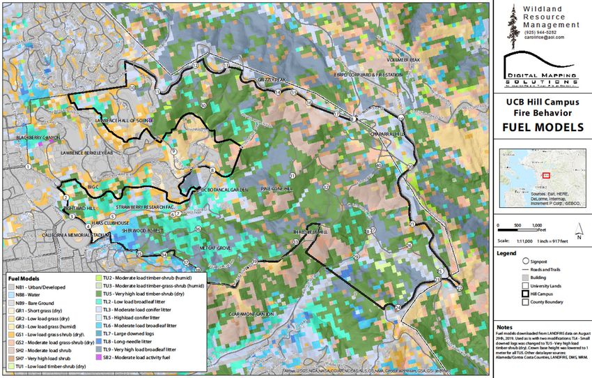
3.10. Vegetative Fuel Models .................................................................................................... 3-12
3.11. Fire Behavior Analysis ....................................................................................................... 3-15
3.11.1. Fire Behavior Summary...................................................................................... 3-15
3.11.2. Weather and Fuel Moisture Conditions ............................................................ 3-18
3.11.3. Fire Behavior with Upslope 20 mph Winds ....................................................... 3-20
3.11.4. Fire Behavior with Northeast 40 mph Winds .................................................... 3-26
4. DESCRIPTION OF PROPOSED TREATMENTS ................................................................................. 4-1
4.1. Description of Proposed Treatments .................................................................................... 4-1
4.1.1. Evacuation Support Treatments ............................................................................ 4-3
4.1.2. Fire Hazard Reduction Treatments ........................................................................ 4-4
4.1.2.1. Access for Treatment Areas .................................................................... 4-5
4.1.2.2. Biomass Disposal for Fire Hazard Reduction Treatments ...................... 4-6
4.1.2.3. Fire Hazard Reduction Projects............................................................... 4-7
University of California, Berkeley
Wildland Vegetative Fuel Management Plan i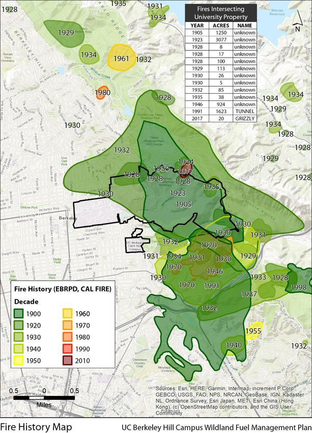
Plan Description Table of Contents

                      4.1.3. Fuel Break Treatments ......................................................................................... 4-10
                              4.1.3.1. East-West Fuel Break Project................................................................ 4-10
                              4.1.3.2. Hearst Gate Fuel Break Project ............................................................. 4-10
                      4.1.4. Creation of Roadside Temporary Refuge Areas .................................................. 4-10
5. DESCRIPTION OF TREATMENT ACTIVITIES ................................................................................... 5-1
       5.1. Manual Vegetation Treatment ............................................................................................. 5-2
       5.2. Mechanical Vegetation Treatment ....................................................................................... 5-2
               5.2.1. Mowing .................................................................................................................. 5-3
               5.2.2. Thinning ................................................................................................................. 5-3
               5.2.3. Yarding ................................................................................................................... 5-4
       5.3. Prescribed Burning ................................................................................................................ 5-4
       5.4. Prescribed Herbivory (Managed Livestock Grazing)............................................................. 5-5
       5.5. Herbicide Application............................................................................................................ 5-6
               5.5.1. Cut Stump Application ........................................................................................... 5-6
               5.5.2. Basal Bark Application ........................................................................................... 5-6
       5.6. Biomass Utilization & Disposal ............................................................................................. 5-7
6. ENVIRONMENTAL PROTECTION MEASURES ................................................................................ 6-1
       6.1. Best Management Practices for Fire Mitigation ................................................................... 6-1
7. PERMITS AND APPROVALS ......................................................................................................... 7-1
      7.1. Federal .................................................................................................................................. 7-1
      7.2. State ...................................................................................................................................... 7-1
      7.3. Local ...................................................................................................................................... 7-1
8. MAINTENANCE AND MONITORING............................................................................................. 8-1
      8.1. Purpose ................................................................................................................................. 8-1
      8.2. Field Investigation (Post-treatment)..................................................................................... 8-2
              8.2.1. Exotic Vegetation Composition ............................................................................. 8-2
              8.2.2. Hydrologic Features ............................................................................................... 8-3
              8.2.3. Photographic Points ............................................................................................... 8-3
              8.2.4. Erosion/Soil Stability .............................................................................................. 8-4
              8.2.5. Woody Plant Resprouting ...................................................................................... 8-4
              8.2.6. Vegetation Composition ........................................................................................ 8-4
              8.2.7. Wood Chip Placement and Depth ......................................................................... 8-4
      8.3. Annual Reporting .................................................................................................................. 8-4
      8.4. Performance Criteria............................................................................................................. 8-5
              8.4.1. Exotic Species Management .................................................................................. 8-5
              8.4.2. Woody Vegetation Composition............................................................................ 8-6
              8.4.3. Wood Chip Placement ........................................................................................... 8-6
              8.4.4. Soil Stability and Erosion........................................................................................ 8-6
      8.5. Adaptive Management ......................................................................................................... 8-6
              8.5.1. Exotic Species Control ............................................................................................ 8-7
              8.5.2. Erosion Control ...................................................................................................... 8-7
              8.5.3. Relocate and Redistribute Wood Chips ................................................................. 8-7
9. REFERENCES ............................................................................................................................... 9-1

University of California, Berkeley
Wildland Vegetative Fuel Management Plan                                                                                                                 ii
Table of Contents Plan Description
LIST OF FIGURES
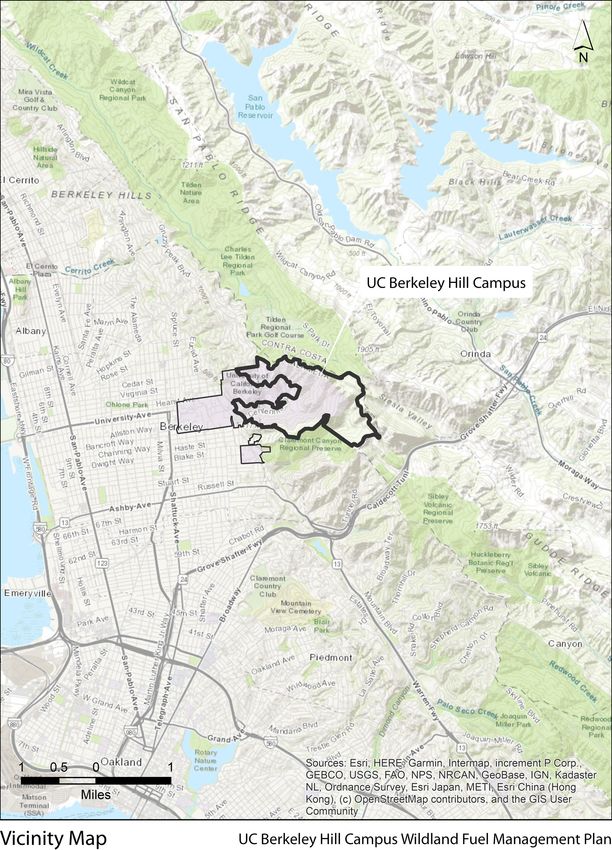
Figure 1. Map of the Hill Campus Vicinity................................................................................................ 2-2
Figure 2. Ongoing Vegetation Treatments in the UC Hill Campus......................................................... 2-11
Figure 3. Prune branches to a height of 8 feet above the ground. In young trees, prune branches
on the lower one-third of the height of the tree. Do not disturb or thin the tree
canopy. This promotes growth in the understory, which is more easily ignited. ......... 2-13
Figure 4. Shrub island spacing. Design groups of plants small enough to provide horizontal
separation between groups. This allows proper maintenance and helps slow the
spread of fire. Each shrub or group of plants should measure no wider than two
times its height, or less than 120 square feet (or 6 feet x 20 feet). The space
between groups should be greater than three times the height of the shrubs............ 2-14
Figure 5. Map of Ongoing Vegetation Treatment Projects Funded by CAL FIRE Grant ........................ 2-16
Figure 6. Fire history of the East Bay Hills................................................................................................ 3-3
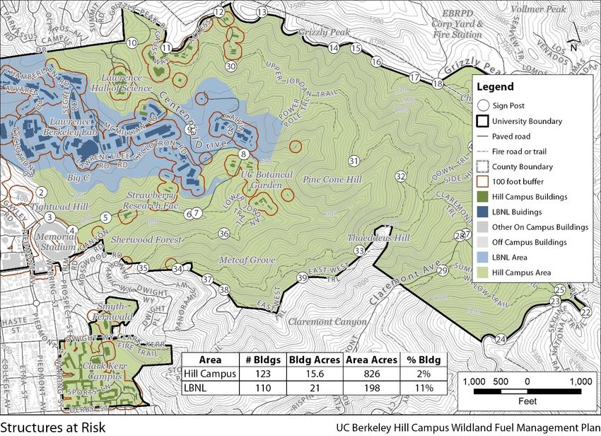
Figure 7. Structures and facilities at risk in the Hill Campus ................................................................... 3-5
Figure 8. Road Classes Indicating Routes Suitable for Skidding, Hauling and Public Permanent
Roads................................................................................................................................ 3-6
Figure 9. Map of Existing Landings in the Hill Campus ............................................................................ 3-7
Figure 10. Current Vegetation Types, from 2016 LandFire Data ........................................................... 3-11
Figure 11. Fuel Model Distribution in the Hill Campus .......................................................................... 3-13
Figure 12. Limits to Fire Suppression Based on Flame Length, Rate of Spread and Heat Per Unit
Area ................................................................................................................................ 3-16
Figure 13. Types of Crown Fires ............................................................................................................. 3-17
Figure 14. Inputs to Fire Behavior Prediction Software FlamMap ........................................................ 3-19
Figure 15. Predicted Flame Lengths with a 20 mile Per Hour Wind Blowing Uphill in all Directions.... 3-20
Figure 16. Predicted Fire Spread Rates with a 20 Mile Per Hour Wind Blowing Uphill in all
Directions ....................................................................................................................... 3-22
Figure 17. Predicted Crown Fire Activity with a 20 Mile Per Hour Wind Blowing Uphill in all
Directions ....................................................................................................................... 3-24
Figure 18. Predicted Maximum Spotting Distance with a 20 Mile Per Hour Wind Blowing Uphill
in all Direction ................................................................................................................ 3-25
Figure 19. Predicted Flame Lengths with a 40 Mile Per Hour Wind Blowing from the Northeast ....... 3-27
Figure 20. Predicted Rate of Fire Spread with a 40 Mile Per Hour Wind Blowing from the
Northeast ....................................................................................................................... 3-29
Figure 21. Predicted Crown Fire Activity with a 40 Mile Per Hour Wind Blowing from the
Northeast ....................................................................................................................... 3-31
Figure 22. Predicted Maximum Spotting Distance with a 40 Mile Per Hour Wind Blowing from
the Northeast ................................................................................................................. 3-33
Figure 23. Proposed Areas of Treatment................................................................................................. 4-2
Figure 24. Example of a Grapple Saw ...................................................................................................... 4-3
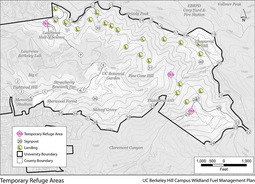
Figure 245. Map of Temporary Refuge Areas ........................................................................................ 4-11
Figure 256. Photographic Documentation of Chip Decomposition......................................................... 5-9
University of California, Berkeley
Wildland Vegetative Fuel Management Plan iii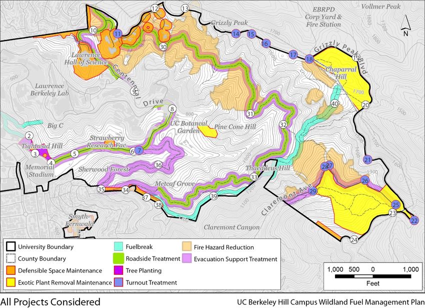
Plan Description Table of Contents

LIST OF TABLES
Table 1. Approximate Acreage of Ongoing Vegetation Treatment Types............................................... 2-9
Table 2. Annual Acres of Ongoing Vegetation Treatments by UC Berkeley .......................................... 2-18
Table 3. Vegetation Types Mapped Through the LandFire Mapping Program (2016 refresh) ............... 3-9
Table 4. Description of Fuel Models ...................................................................................................... 3-14
Table 5. Acreages of Proposed Projects .................................................................................................. 4-1
Table 6. Treatment Activities ................................................................................................................... 5-1
Table 7. Exotic Plants Known to Occur in the Proposed Plan Area ......................................................... 8-2
Table 8. Monitoring and Reporting Schedule .......................................................................................... 8-5

University of California, Berkeley
Wildland Vegetative Fuel Management Plan                                                                                                           iv
1. EXECUTIVE SUMMARY
The Wildland Vegetative Fuel Management Plan (WVFMP or Plan) proposes treatments of vegetation
and associated fuels within the 800-acre UC Berkeley Hill Campus (Plan Area or Hill Campus) to
improve public safety and reduce losses/damage from wildland fire.

This Plan describes the wildland fire management objectives, provides context to regional planning by
highlighting partnerships, and highlights both past and current vegetation treatments and the regional
planning context in terms of partnerships and both past and current vegetation treatments.

The WVFMP then characterizes existing conditions, focusing on wildland fire aspects that influence
wildfire threats, response, and potential management, such as fire history, hazard ratings, access,
topography, water resources, plant and wildlife resources, and vegetative fuel models. A detailed fire
behavior analysis is presented that predicts flame lengths, fire spread rates, potential for crown fire,
and spot fire distribution.

Vegetation treatments are proposed that address the existing conditions. These treatments and are
categorized as Evacuation Support Treatments, Fire Reduction Treatments, Fuel Break Treatments, and
Creation of Roadside Temporary Refuge Areas. Each vegetation treatment type achieves different goals
and objectives.

Treatments are conducted through a variety of activities, which are described in the Plan. These
activities include manual vegetation treatment, mechanical vegetation treatment, prescribed burning,
managed herbivory (livestock grazing), herbicide application, and biomass utilization and disposal. Any
of the activities could be used singularly or in combination to implement any of the goals of the
treatment types. Proposed projects have been designed and are described herein, including the
location, goal, and vegetation treatment activity/activitiesactivi(ies) of each project.

A set of best practices and environmental protection measures are included in this Plan, along with a
list of permits and approvals that could be required. A program that ensures ongoing maintenance,
monitoring, and adaptation is also included.

The Plan will bewas reviewed and accepted by the UC Berkeley Fire Mitigation Committee. The Office
of the Chancellor is the UC Berkeley decision-making body with discretionary authority to approve the
Plan.

University of California, Berkeley
Wildland Vegetative Fuel Management Plan                                                                1-1
Plan Description Executive Summary

This page intentionally left blank.

University of California, Berkeley
Wildland Vegetative Fuel Management Plan   1-2
2. OVERVIEW OF THE PLAN
The Wildland Vegetative Fuel Management Plan (WVFMP or Plan) for the UC Berkeley Hill Campus
(Plan Area or Hill Campus) is proposed by the University of California, Berkeley (UC Berkeley) to treat
vegetative fuels within the Plan Area. The WVFMP covers vegetation management to improve public
safety and reduce potential impacts of a wildland fire. The Plan serves as one component of UC
Berkeley’s range of actions to reduce wildfire risk and minimize the potential for harmful effects of
wildfire on people, property, and natural resources within the 800-acre Plan Area, as shown in Figure
1. As part of the Plan, UC Berkeley would implement vegetation treatment activities on approximately
300 acres annually within the Plan Area.

The Plan will be reviewed by the UC Berkeley Fire Mitigation Committee, an interdepartmental body
comprising UC Berkeley staff and faculty. The Office of the Chancellor is the UC Berkeley decision-
making body with discretionary authority to approve the Plan.

The WVFMP presents a multifaceted approach to vegetation treatment. The Plan includes different
vegetation treatment types, each achieving different goals and objectives. The vegetation treatment
types are fire hazard reduction, evacuation support, temporary refuge areas, and fuel breaks. The Plan
also describes vegetation treatment activities that would be implemented to achieve the goals of each
treatment type. The vegetation treatment activities are manual treatment, mechanical treatment,
prescribed burning, prescribed herbivory (livestock grazing), and targeted ground application of
herbicides. Any of these activities could be used singularly or in combination to implement any of the
goals of the treatment types. Proposed projects have been designed and are described herein,
including the location, goal, and vegetation treatment activity/(activities) of each project.

The WVFMP does not include other aspects of fire management, such as ignition detection (including
installation of cameras or increased roving patrol), a program to enhance fire suppression capabilities
(emergency response), or the placement of water tanks in remote areas of the Hill Campus. This Plan
focuses on fuel management through vegetation treatment only.

A fuel management plan focuses on vegetation management to alter fire behavior, potentially to
decrease ignitability, and reduce fire intensity and heat output so that fires can be contained and
suppressed more easily, resulting in smaller, and less damaging wildfires. In contrast, a wildfire
management plan typically includes all aspects of wildland fire management, including ignition
detection, reporting (i.e., communications), response (encompassing water supply, designated
authorities, and communications), and post-fire recovery. A wildfire management plan is typically a
large document that includes a detailed fire prevention plan that encompasses patrols, education and
public outreach, property closure triggers, and operations plans. A wildfire management plan also
includes details on wildfire response, such as hydrant locations, engine response times, landowner
responsibilities during a wildfire (including evacuation support), and post-wildfire actions including
maintenance.

University of California, Berkeley
Wildland Vegetative Fuel Management Plan                                                              2-1
Plan Description Overview of the Plan

Figure 1. Map of the Hill Campus Vicinity

University of California, Berkeley
Wildland Vegetative Fuel Management Plan    2-2
Overview of the Plan Plan Description

2.1. PLAN OBJECTIVES
The objectives of the Plan guide its implementation and will help UC Berkeley to plan, budget for,
execute, and monitor the results of its actions. The objectives of the Plan are to:

    •    Increase the Plan Area’s resistance to catastrophic wildfire to reduce the potential for loss of
         human life and property damage from wildfire.

    •    Provide a range of vegetation treatment and maintenance activities in a manner that mitigates
         adverse environmental effects.

    •    Thin vegetation to reduce the likelihood in a wildfire event of ember production in a wildfire
         event starting new fires (known as ember cast).

    •    Increase the pace and scale of vegetation treatment and maintenance activities to reduce the
         overall fuel volume available to burn, thereby increasing the probability of containment of a
         future fire.

    •    Manage invasive plant species and promote fire-resistant native plant species to reduce wildfire
         risks and enhance biodiversity.

    •    Maintain the visual character of the Plan Area for recreational users and neighboring
         communities.

    •    Enable UC Berkeley staff to make informed and adaptive management decisions that are cost-
         effective and environmentally sustainable.

    •    Maintain an active role in regional efforts to reduce wildfire hazard in the East Bay hills.

2.2. REGIONAL WILDFIRE RISK REDUCTION PLANNING
The Plan is consistent with local and state codes and ordinances that pertain to wildfire risk reduction.
More than twenty reports and/or plans address wildfire hazard in the Oakland/Berkeley Hills, and the
Plan is consistent with or considers information in the following campus, regional, and statewide
vegetative fuel management documents:

    •    UC Berkeley, 2020 Long Range Development Plan (2005) – includes policies to manage
         vegetation in the Plan Area to reduce fuel load focusing on high-hazard introduced species.

    •    CAL FIRE Santa Clara Unit Plan, Strategic Fire Plan (2018) – identifies the 16,200 acre
         Oakland/Berkeley Hills as a Priority Area, and specifically mentions the 1991 Oakland Tunnel
         Fire, which destroyed 3,000 homes for a loss of 1.8 billion dollars, and identifies the “Berkeley
         upper Strawberry Canyon fuel reduction project” as a priority vegetation reduction project in
         Claremont Canyon. The Plan Area encompasses both canyons.

University of California, Berkeley
Wildland Vegetative Fuel Management Plan                                                                          2-3
Plan Description Overview of the Plan
• CAL FIRE, California Strategic Fire Plan (2018) – provides a roadmap for reducing the risk of
wildfire in the state by focusing on fire prevention and suppression activities and natural
resource management to maintain the state’s forests as resilient.
• 2018 State of California State Hazard Mitigation Plan – represents the state’s primary hazard
mitigation guidance document that includes discussions on wildfire and structural fire hazards
and provides a mitigation plan for an effective wildfire suppression plan.
• Alameda County Community Wildfire Protection Plan (2015) – provides a comprehensive
analysis of wildfire hazards and risks, and identifies proposed projects to reduce the risk of
wildfire in the wildland-urban interface areas of Alameda County. The Plan prioritizes
vegetation treatment projects in the Plan Area.
• East Bay Regional Park District, Wildfire Hazard Reduction and Resource Management Plan
(2009) – identifies a framework for undertaking ongoing vegetation management activities on
park lands in the East Bay hills in Alameda and Contra Costa counties adjacent to the Plan Area.
• East Bay Municipal Utility District, East Bay Watershed Fire Management Plan (2000) – guides
the implementation of fire protection and preparedness activities that meet key watershed
management objectives adjacent to the Plan Area.
• Lawrence Berkeley National Laboratory, Federal Wildland Fire Management Plan (2015) –
provides a comprehensive wildland fire management plan to be implemented by LBNL on LBNL-
managed property in the Hill Campus.
• City of Oakland, Draft Vegetation Management Plan (2019) – includes a framework for
managing fuel loads and high hazard vegetation management activities to reduce fired hazard
on approximately 1,300 acres within the City of Oakland, including Claremont Avenue and
Garber Park, located immediately south of the Plan Area.
• City of Berkeley Wildfire Evacuation Plan (Draft) (2019) – The City of Berkeley's Fire and
Rescue Department recognizes the threat wildfire poses to its approximately two thousand
residents in neighborhoods north and south of the Plan Area and establishes a High Fire Hazard
District. Centennial Drive has been identified as one of only three evacuation routes in its newly
revised evacuation plan.
2.3. PARTNERSHIPS
The proposed treatments included in this Plan are part of a regional effort to remove high hazard fuels
and reduce risks from wildfires in high hazard areas by installing and maintaining major ridgetop fuel
breaks and improve public safety within evacuation corridors for the communities of Oakland,
Berkeley, and other East Bay municipalities. UC Berkeley works closely with internal and external fire
management partnerships which have assisted in the development of the Plan, including Hills
Emergency Forum (HEF), Diablo Firesafe Council, and various neighborhood groups, along with internal
interdisciplinary planning teams. HEF has partnered with UC Berkeley as a technical advisor of the Plan;
Diablo Firesafe Council has partnered with UC Berkeley for community outreach and liaison; and the
University of California, Berkeley
Wildland Vegetative Fuel Management Plan 2-4Overview of the Plan Plan Description
Alameda County Resource Conservation Service for oak planting coordination. UC Berkeley maintains
the following partnerships:
• Hills Emergency Forum (HEF): UC Berkeley participates regularly in HEF, an inter-agency
organization of nine partner agencies in the East Bay hills aimed at regional wildfire prevention
and protection. The nine members coordinate collection, assessment and sharing of
information on East Bay hills fire hazards, and HEF provides a forum for building interagency
consensus on developing fire safety standards and codes, incident response and management
protocols, public education programs, multi-jurisdictional training, and vegetation reduction
strategies.
• Diablo Firesafe Council: UC Berkeley supports and collaborates with the Diablo Firesafe
Council, a non-profit organization that provides resources to coordinate public and private
landowners in Alameda and Contra Costa counties to reduce the threat of wildfire. UC Berkeley
staff has attended and participated in its Partners in Prevention event and will continue to do
so. UC Berkeley also supports the local Diablo Firesafe Council in the development and
implementation of the Alameda County Community Wildfire Protection Plan (2015).
• Special Districts: Open Space lands owned and managed by the East Bay Municipal Utility
District (EBMUD) and East Bay Regional Park District (EBRPD) lie immediately to the east and
south of the Plan Area. EBMUD owns and manages land and waterbodies and is responsible for
management surrounding nearby reservoirs. EBRPD owns and manages Tilden Regional Park to
the east and Claremont Canyon Regional Preserve to the south of the Plan Area. Both agencies
continue to implement vegetation management activities on its open space lands. UC Berkeley
and these special district partners actively manage open spaces by installing and maintaining
regional ridgeline fuel breaks that increase fire safety for landowners.
• Pacific Gas & Electric (PG&E): PG&E provides electricity to UC Berkeley (and LBNL) from a
substation in the Plan Area, and the Plan Area encompasses right-of-way for overhead
transmission lines. UC Berkeley collaborates with PG&E to treat vegetation in the Hill Campus
along PG&E’s electric transmission line right-of-way to increase power reliability and reduce
both ignition potential, and resulting wildland fire hazard.
• Lawrence Berkeley National Lab (LBNL): UC Berkeley partners with LBNL to actively install and
maintain regional ridgeline fuel breaks. LBNL manages its property to ensure safety for its
facilities and employees. In addition, since 1996, LBNL has maintained about 75 acres of UC
Berkeley property in the Hill Campus for fire safety, consistent with its LRDP, under a Letter of
Cooperation.
• Cities: The cities of Oakland and Berkeley inspect homes for defensible space compliance
where they are adjacent to the Plan Area and cooperatively maintain road rights-of-way on
routes abutting the Plan Area. UC Berkeley and the cities of Oakland and Berkeley participate in
inspection and maintenance of defensible space on UC Berkeley land (including within the Plan
area) and adjacent private and public properties.
University of California, Berkeley
Wildland Vegetative Fuel Management Plan 2-5Plan Description Overview of the Plan 2.4. PAST AND ONGOING VEGETATION TREATMENTS 2.4.1. HISTORY OF FIRE AND FUEL MANAGEMENT PLANNING IN THE HILL CAMPUS The first known recommendations for fire management planning in the UC Hill Campus were recorded seven days after the Berkeley Fire in 1923. Nelson et al (1923) reported that this fire not only devastated a portion of the residential section, but also spread along the Berkeley Hills south to Tunnel Road in less than four hours. The group recommended the eucalyptus and pine trees killed by fire be either piled and burned or utilized for firewood. They recommended the forested areas which were burned be planted with fire resistant species, such as Redwood, to provide greater shade. The group also recommended increased education, prevention, and detection and suppression activities. A Study of the Long Term Use Potential of Strawberry Canyon and the Undeveloped Hill Lands (chaired by Robert L. Cockrell) recommended in 1958 that access be improved on the north facing slope and that water supplies (mains and hydrants) be established along major roads traversing the south and head of the canyon (Cockrell, 1958). Dr. Harold Biswell prepared a thorough report in 1974 of "The Wildfire Problem and Management Plan for the Reduction of Fire Hazards in the Hill Area of the University Campus.” He advocated controlled broadcast burning under the coniferous stands, in the briars, as well as in the grassland and chaparral. Additionally, Dr. Biswell recommended the eradication of eucalyptus sprouts and French broom. Lastly, he suggested more coast live oak be planted in lieu of the north coastal scrub on the north facing slopes of Strawberry Canyon, as well as in other locations (Biswell, 1974). Garret Eckbo and Associates included fuel management recommendations as part of a campus-specific Vegetation Plan in "A Land Use and Vegetation Management Study” (1976). This study classified existing vegetation units. Desired vegetation was stated for each unit, and fuel management prescriptions were specified. This study called for conversion of a major portion of eucalyptus sprouts to grass, greatly increased conifer plantations, and oak/bay woodland. The fuel management techniques that were often suggested were to pile and burn large diameter fuels every 25 years, broadcast burning at 10 or 25 year intervals, hand clearing, piling and burning soft chaparral, and cutting sprouts (then two years old) then treating with the chemical 2,4,D, which is also known as 2,4- Dichlorophenoxyacetic acid. The study also recommended the use of goats and cattle to clear brush and maintain grassland. As a start of implementing the Garrett Eckbo report, Mark Hamlin, a contractor who prepared a report for UC Berkeley’s Office of Environment, Health & Safety, recommended the creation of a fuel break in the conifers and brush north of Panoramic Hill. Reduction of fuels was to be accomplished using controlled broadcast burns. The UC Berkeley Committee on Conservation and Environmental Quality submitted in 1978 a "Proposed Management Plan for Strawberry and Claremont Canyons” (McBride, 1978). This committee recommended that a fuel management zone 100 feet wide be established on UC boundaries where they are adjacent to residential property. The density of shrubs and trees were to be reduced in this strip, trees limbed, and mulch burned on a periodic basis. An experimental forest was proposed for the Claremont Canyon area. University of California, Berkeley Wildland Vegetative Fuel Management Plan 2-6
Overview of the Plan Plan Description

A UC Berkeley/EBRPD Joint Agency Fuel Management Plan for the Dwight Derby Site/Berkeley Open
Space Regional Park was issued in 1983 where the area behind the Clark Kerr Campus and at the base
of Panoramic Hill was to be managed with hand crews, goats and broadcast burning to reduce fire
hazard in the area. In 1984, the Hill Area Task Force recommended vegetation management activities
in limited areas of the Hill Campus. The group recommended that eucalyptus sprouts be removed. The
establishment of a 100-foot wide buffer zone along UC/private property boundaries was proposed to
reduce fire hazard. The Task Force endorsed clearing, pruning, and prescribed burning to maintain
discontinuous fuel distribution in the buffer zone. Roadsides were to be mowed each spring.

A 1986 Plan by C.L. Rice and R. Aronson proposed a suite of treatments in all vegetation types
throughout the Hill Campus (Rice and Aronson, 1986). Eucalyptus sprouts (then 13 years old) were
removed on approximately 50 acres, goats grazed 40 acres, and five prescribed burns were
conducted.1 The understory of coniferous forests on the north-facing spurs below the Jordan Fire Trail
were thinned. Oak trees were planted in the area south of the satellite dish, now encompassed by
LBNL, and native grass seed was distributed on Chaparral Hill. The plan was implemented until 1991,
just months before the Oakland Tunnel Fire.

The 2020 Hill Area Fire Fuel Management Program (2003) is currently being implemented by UC
Berkeley in the Hill Campus to reduce fire risk to the campus, LBNL, neighboring residents, and
recreational visitors to adjacent park and watershed lands. The program, which was prepared by Safe
Solutions Group (2003), approaches fuel management by offering a broad set of priorities and decision
criteria for treatments. The program prioritizes defensible space treatments both around structures
and along property boundaries. The program does provide a process for larger-scale treatments, which
allow for eucalyptus removal in Claremont Canyon and goat grazing near MSRI. The program also
recommends roadside and evacuation treatments that could extend to 100-feet from pavement edge,
as funding allows. Ongoing vegetation management activities under this plan are largely funded and
implemented by Facilities Services Department. While a baseline level of funding is provided to
conduct treatments required by law, maintenance and larger treatments are undertaken as funding
becomes available. This program would be replaced and superseded by this WVFMP.

2.4.2. PAST VEGETATION TREATMENTS

UC Berkeley has managed the Plan Area for fire hazard reduction for decades. The 1980s saw a
combination of treatments in Strawberry Canyon that spanned prescribed burns, goat grazing,
eucalyptus removal, and forest thinning with hand crews.2 In the 2000s, efforts focused on eucalyptus
removal in Claremont Canyon. 3

More recently, UC Berkeley Facilities Services Department has planned for and undertaken regular
vegetation treatment activities in the Plan Area. The vegetation treatments are reviewed and approved
by the Fire Mitigation Committee, an inter-departmental committee headed by the Scott Stephens,
Wildland Fire Science professor from the College of Natural Resources, with representation from the
university’s Facilities Services, Environmental Health and Safety, Lawrence Berkeley National
Laboratory Protective Services, and UC Berkeley Police and Capital Projects departments. The

1
  Prescribed burns were conducted at the following locations: Lawrence Hall of Science (3 times), Botanical Garden 1988),
Panoramic Hill, Tightwad Hill, Big C eucalyptus grove.
2
  Fire Prevention Committee meeting minutes, 1986-91.
3
  Fire Mitigation Committee meeting minutes 2000-2011.
University of California, Berkeley
Wildland Vegetative Fuel Management Plan                                                                                    2-7
Plan Description Overview of the Plan

treatments covered by the 2020 LRDP EIR that Facilities Services has implemented over the years in the
Plan Area include:

     •    Remove dead trees and hazardous trees or limbs that pose an imminent public safety risk;
     •    Remove vegetation along 100 feet of either side of roadways and trails to maintain emergency
          evacuation access;
     •    Provide defensible space, by removing vegetation within 100 feet of all structures consistent
          with the California State Public Resources Code (PRC) 4291; and
     •    Remove vegetation along a 15-foot strip of land adjacent to roads and near property
          boundaries, and a 50-foot radius of designated turnouts along Grizzly Peak Boulevard and
          Claremont Avenue.
Typically, vegetation treatment activities carried out by Facilities Services is implemented by hand
crews and hand-held tools, with occasional use of machinery to cut grass and shrubs and to chip
woody material. Herbicide is applied by hand-held tools to roadside vegetation; however, it is currently
limited in its use. Removal of exotic plants occurs in areas previously treated. In recent years, Facilities
Services has replaced hazardous Monterey pine trees with fire-resistant trees, shrubs, and grasses on
an area known as Tightwad Hill. In addition, the Claremont Canyon Conservancy, UC Berkeley Forestry
Club and a local non-profit, Take to The Hills, have participated in maintaining prior treatments in the
Plan Area through the removal of flammable exotic invasive species and planting of less flammable
species. The combined efforts typically exceed 500 volunteer-days annually. Additionally, UC Berkeley
has participated in and will continue to participate in Wildfire Awareness events organized by the
Berkeley City Council.

2.4.3. HISTORY OF EUCALYPTUS MANAGEMENT IN THE HILL CAMPUS

While certain eucalyptus stands in the Hill Campus have been actively managed, others have been
neglected. Some eucalyptus stands have been treated three times through thinning, pruning,
understory removal, and overstory removal – often with herbicide application to the cut stumps. In
some stands, trees have been cut and herbicide applied to the stumps. Most eucalyptus trees in the
Hill Campus have been cut and treated with herbicide twice, whereas some small stands of eucalyptus
have never been removed. In all areas of treatment tree trunks were removed.

In 1974 FEMA provided millions of dollars via a grant to create a multi-jurisdictional fuel break that
covered the East Bay hills. The fuel break project was aimed at removing eucalyptus trees that were
top-killed from a freeze in 1973 and played an important role in determining current conditions of the
fuels in the Hill Campus because the structure of the eucalyptus stands changed. Almost all of the
eucalyptus trees that were cut resprouted, despite being treated with herbicide after cutting.

Approximately 50 acres of the then 12-15-year-old eucalyptus sprouts were cut between 1988 and
1991 in Strawberry Canyon and on top of Chaparral Hill. Again, most of the eucalyptus trees in
Strawberry Canyon resprouted despite being treated with herbicide after cutting.

UC Berkeley cut approximately 90 acres of 20-year old eucalyptus sprouts in Claremont Canyon
between 20015-201106, and because of effective herbicide application did not experience any

University of California, Berkeley
Wildland Vegetative Fuel Management Plan                                                                  2-8
Overview of the Plan Plan Description
significant resprouting. Approximately 2 acres of 24-year old eucalyptus resprouts near signpost 18
were cut and left to sprout again.
Hazard trees throughout the Hill Campus were felled as necessary between 1974 and 2019. Most
recently, hazardous trees around one building in the Field Station for the Study of Behavior, Ecology
and Reproduction (FSSBER) were felled in 2019, and trees that might block evacuation and access
along a swath 100 feet on both sides of Centennial Avenue, were removed in 2019-2020, as shown on
Figure 5. This treatment did not target eucalyptus, however most of the trees removed were
eucalyptus because they were adjacent to the road and were more likely to block access or egress.
2.4.4. ONGOING VEGETATION TREATMENTS
Using funding received by CAL FIRE California Climate Investments Forest Health Grant, Facilities
Services expanded its ongoing vegetation treatment and maintenance activities in the Plan Area that
are covered by the 2020 LRDP EIR to implement treatments to improve emergency access and
evacuation support within 100 feet of either side of large portions of Centennial Drive, as shown on
Figure 5. Total area of vegetation removed in the winter of 2019-2020 was 33.3 acres within the Plan
Area, which comprises an area 100-feet from pavement edge along the UC Berkeley-managed length
of Centennial Drive (see Figure 5). UC Berkeley proposes to conduct a similar evacuation treatments
support project along upper portions of Claremont Avenue covering roughly 18 acres within the Plan
Area (see Figure 5), and 89 acres along the Jordan Fire Trail. The Centennial Drive, Claremont Avenue
and Jordan Fire Trail treatments are consistent with CAL FIRE guidelines as they appear in Protective
Practices for CAL FIRE’s 35 Emergency Fuels Reduction Projects dated April 5, 2019.4
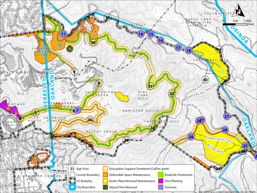
Current vegetation treatments take the form of Defensible Space Creation and Maintenance, Roadside
Treatments, Turnout and Signpost Treatments, Exotic Plant Removal and Maintenance, as well as
Evacuation Support, Hazard Tree Removal, and Replanting with Fire-resistant Vegetation. The total
acreage of these types of treatments is 308 acres, as shown on Figure 2. Generally, treatments occur
annually, however the Evacuation Support Treatments have been limited by funding, and will take
place in 2019-2021, and periodically thereafter.
Table 1. Approximate Acreage of Ongoing Vegetation Treatment Types
Ongoing Vegetation Treatment Types Approximate Acreage
Total Defensible Space 68
Total Roadside Treatments 3
Total Turnout Treatments 2
Total Exotic Plant Removal 76
Total Evacuation Support Treatments 151
Hazard Tree Removal 5
Replanting 3
Total 308
4
http://leginfo.legislature.ca.gov/faces/codes_displaySection.xhtml?lawCode=PRC§ionNum=4291;
http://resources.ca.gov/wp-content/uploads/2019/04/Signed-North-Orinda-Waiver.pdf
University of California, Berkeley
Wildland Vegetative Fuel Management Plan 2-9Plan Description Overview of the Plan University of California, Berkeley Wildland Vegetative Fuel Management Plan 2-10
Overview of the Plan Plan Description

Figure 2. Ongoing Vegetation Treatments in the UC Hill Campus.

University of California, Berkeley
Wildland Vegetative Fuel Management Plan                                                          2-11
Plan Description Overview of the Plan

2.4.4.1. Defensible Space and Roadside Treatments

Since 2014, UC Berkeley has applied the set of standards below to direct initial treatments and
maintenance activities in the Roadside Treatment and Defensible Space Maintenance areas in the Plan
Area. The standards for the Roadside Treatments apply to the strip of land within 15 feet of the
pavement edge from both sides of designated roadways. The Defensible Space Maintenance area
applies to areas within 100 feet of any structure, unless specified otherwise. These distances are
consistent with California State PRC 4291.

2.4.4.2. Standards for Defensible Space

     •    A minimum of five-foot wide zone (the Non-Combustible Zone) nearest the structure should be
          kept free of all woody plants and combustible materials.
     •    Keep the ground free of dead leaves, mulch, needles or other plant debris. The ground surface
          should be composed of inorganic, non-combustible, material such as decomposed granite,
          pebbles, or rock/flagstone.
     •    Vegetation in the non-combustible zone could include irrigated lawns and succulents but would
          exclude woody plants.
     •    Dead material that drapes over ground cover will be removed. This includes leaves, bark, and
          branches.
     •    Cut and chip trees with a high fuel volume that are at risk of falling on buildings, structurally
          unsound, or are unhealthy. Large, “legacy trees” that are structurally sound, and with branches
          that are 30-40 feet above ground will be retained.
     •    Remove all dead plants and dry vegetation.
          o Cut grass and weeds within 15-feet of the pavement edge and within 30-feet of a structure
              to less than four inches in height.
          o Remove leaves, bark, and humus under trees and shrubs (including vines and semi-woody
              species) so that the buildup of leaves and humus will not exceed two inches in depth
              anywhere in a defensible space within a year. However, do not expose bare earth in over 50
              percent of the site.
          o Remove dead material that drapes over ground cover (including leaves, bark, and
              branches).
          o From mature trees, remove all vines, loose papery bark, dead branches, and live branches
              smaller than three inches in diameter to a height of 8 feet above the ground.
          o Remove all dead branches from within live ground covers, vines, shrubs (including semi-
              woody species), and immature trees.
     •    Prune trees and large tree-form shrubs (e.g., elderberry or toyon) that are being retained.
          o All lower tree branches, under three inches in diameter, will be removed up to eight feet
              above the ground, or on the lower third of trees, whichever is less (see Figure 3, below). OR,
          o All lower tree branches, under three inches in diameter, will be removed to provide vertical
              clearance of three times the height of the understory plants, or eight feet above understory
              plants, whichever is greater. Retention of short understory shrubs provides aesthetic
              benefits and wildlife habitat without sacrificing fire safety; alternatively, trees will be
              pruned to a higher height in order to allow for screening from the understory shrubs.
          o In young trees, remove the branches on the lower one-third of the height of the tree.
              Example: if a tree is 10 feet tall, prune the lower 3-4 feet and keep the understory plant

University of California, Berkeley
Wildland Vegetative Fuel Management Plan                                                                 2-12
Overview of the Plan Plan Description
material to less than one feet in height. As the tree grows to 24 feet in height, it can achieve
the eight-foot distance from the ground, and the understory plant material can reach 2.5
feet in height.
Figure 3. Prune branches to a height of 8 feet above the ground. In young trees, prune branches on
the lower one-third of the height of the tree. Do not disturb or thin the tree canopy. This promotes
growth in the understory, which is more easily ignited.
• All dead branches smaller than three inches in diameter will be removed. All dead limbs greater
than three inches in diameter should be retained where they do not pose a public safety of fire
risk.
o Do not thin or prune the upper tree canopy, as this will promote more growth in the lower
parts of the tree and may result in increased risk that fire will spread to the tree canopy.
o Sometimes small trees may need to be cut to the ground in order to achieve the separation
of the ground level from another, larger, tree canopy, or because mowing equipment
cannot avoid the small trees.
o Maintain at least eight feet of vertical clearance between roof surfaces and overhanging
portions of trees.
• Manage individual plants or shrub masses to maintain horizontal spacing, per Figure 4 below.
Design distinct groupings of shrubs (including vines, semi-woody species, all types of brush, and
all chaparral species). Make sure the plant groupings are small enough to provide adequate
horizontal separation between groupings and to allow proper maintenance; groupings should
measure no wider than two times the grouping height, or 120 square feet. The space between
islands should be greater than three times the height of the shrubs (see Figure 4).
• Remove and safely dispose of all cut vegetation and hazardous refuse, using a gasifier or air-
curtain type burner wherever possible.
• Chipped materials may remain on site, provided the mulch layer is no greater than three inches
in depth.
University of California, Berkeley
Wildland Vegetative Fuel Management Plan 2-13Plan Description Overview of the Plan
Figure 4. Shrub island spacing. Design groups of plants small enough to provide horizontal separation
between groups. This allows proper maintenance and helps slow the spread of fire. Each shrub or
group of plants should measure no wider than two times its height, or less than 120 square feet (or 6
feet x 20 feet). The space between groups should be greater than three times the height of the
shrubs.
2.4.4.3. Standards for Roadside Treatments
Within 10 feet of road pavement edge:
• Grassland vegetation and invasive weeds will be mowed to a 4-inch height or treated with
herbicide annually before the grass grows to an average of four inches in height. In unusual
circumstances when rains occur after grass is mowed, grass may be allowed to regrow or need
to be re-mowed.
• Understory shrubs will be removed under trees or shortened to create a vertical distance
between the top of the shrub and the bottom of the tree canopy of three times the shrub
height.
• Trees will be pruned of lower branches (to 8 feet in height, or the lower third of branches).
• All tree branches extending over roadway surfaces should be pruned to ensure at least 15 feet
of vertical clearance.
2.4.4.4. Evacuation Support Treatments
Evacuation support treatment project areas are identified on Figure 5. In all areas, vegetation
treatment for evacuation support focuses on removing highly flammable trees, understory shrubs and
small trees that could enable torching, and trees that may block access/egress should they fall. The
goal for evacuation support treatments is to improve public safety and reduce loss from wildfires by
supporting the conversion of the existing fire-prone forest to vegetation with more favorable burning
characteristics.
In areas located within 100 feet of Centennial Drive, Claremont Avenue, and Jordan Fire Trail (see
Figure 5) vegetation treatments focus on achieving a two to four-foot predicted flame length
immediately after treatment. Vegetation treatments aim to remove high-volume vegetation and create
discontinuity in the fuel so that in the event of fire, the rate of spread is slowed, and flame lengths
meet the treatment goal in treated areas. UC Berkeley treats and maintains the first 10 feet from the
pavement edge for evacuation support treatments, as described above in Sections 1.4.4.3.
University of California, Berkeley
Wildland Vegetative Fuel Management Plan 2-14Overview of the Plan Plan Description In the Plan Area, UC Berkeley removes all dead, unhealthy or trees leaning toward Centennial Drive, Rim Way, Claremont Avenue and Jordan Fire Trail. “Specimen” trees identified by the UC Berkeley landscape architect that are healthy and that do not pose a public hazard are retained, per the campus Specimen Tree Program (UC Berkeley, 1990), and all shrubs under them removed. Trees to be retained are protected during treatment periods. UC Berkeley applies practices consistent with those used by the International Society of Arboriculture and follows current California Forest Practice Rules. In evacuation support treatment areas, UC Berkeley removes lower branches of all trees to a minimum height of 8 feet, and understory vegetation. Shrubs are removed or thinned to a minimum spacing of 6 feet. Surface vegetative fuels may include short shrubs with little dead material, leaf litter, annual and perennial grass. Taller shrubs may be present well away from a tree canopy. Grass is cut every fire season within 10 feet of the pavement edge of Centennial Drive, Rim Way, and Jordan Fire Trail. Branches hanging over roadbeds or fire trails are trimmed to a height of 15 feet above ground. Dead surface fuels smaller than six inches in diameter are removed. Leaf litter of less than six inches in depth is typically left and dead trees are removed. Chips will cover most surfaces within the area upon completion of the treatment; in this treatment area chip depth can be as deep as six inches. See https://facilities.berkeley.edu/news/centennial-drive-evacuation-support-project for details of the prescription. University of California, Berkeley Wildland Vegetative Fuel Management Plan 2-15
You can also read