A Citizens' Guide to "Bear Hole" West Springfield, Massachusetts - An informational guide to West Springfield's watershed and conservation area ...
←
→
Page content transcription
If your browser does not render page correctly, please read the page content below
A Citizens’ Guide to “Bear Hole”
West Springfield, Massachusetts

 An informational guide to West Springfield’s watershed and conservation area.
            Christopher J Dunphy - Westfield State University
                                October 2013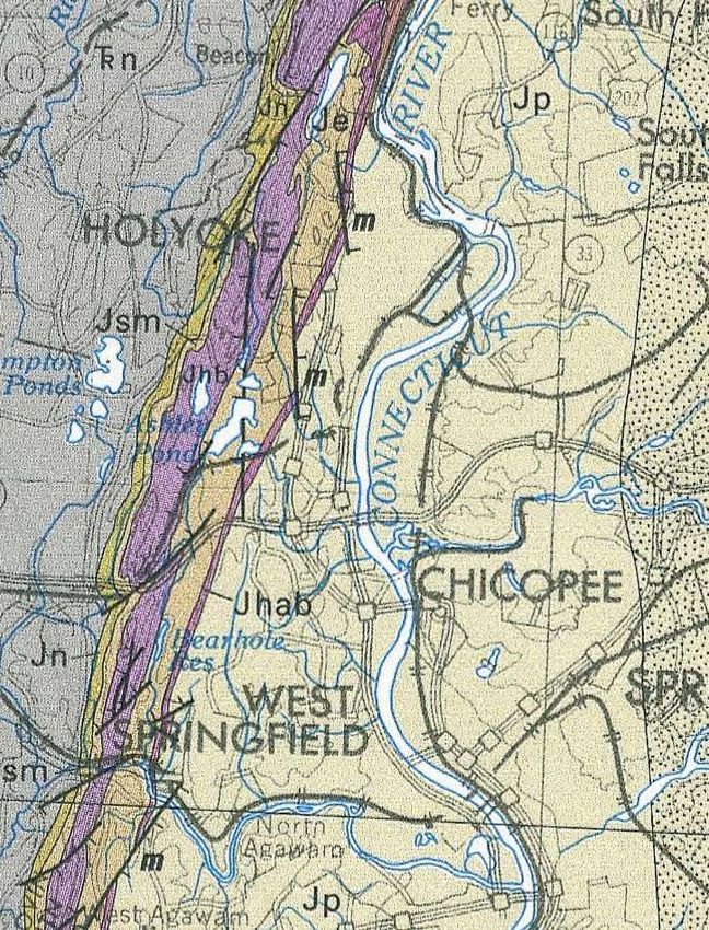
Citizens’  Guide  to  “Bear  Hole”  – Table of Contents 2013

INTRODUCTION                                      1
HISTORY                                           2

   Geological                                     2
   Native American Presence                       6
   Contact Period and Economic Expansion          12
   Bear  Hole’s  Resort  Experience               21
BEAR HOLE TODAY                                   29
   Bear Hole and Bear Hole Watershed              29
   Places of Interest                             43
   The Reservoir and former resort area           43
   BioMap2 Area (North of Turnpike)               44
  Metacomet/East Mountain Ridge and the           47
  New England National Scenic Trail
  Bear Hole Wildlife                              52
BEAR HOLE PROBLEMS AND CONCERNS                   59
   Reservoir and Dam                              61
   Off-road Vehicles and Illegal Dumping          63
   Wooly Adelgid                                  68
   Illegal Hunting                                69
   Forestry                                       72
   Sprawl                                         73
CONCLUSION                                        75
REFERENCES                                        81
INTRODUCTION

“The  dark  passage  of  Paucatuck Brook in West Springfield through the hemlock woods southeast of
Bush’s  Notch  has  borne  the  name  of  Bear  Hole  in  the  eighteenth  century  and  perhaps  earlier.”  1
– Charles H. Barrows

Rocky ledges, swamps, vernal pools, a pine forest, open grasslands, a railroad line or an old logging road
are what famous ecologist Aldo Leopold had in mind when he described the "edge effect" and
biodiversity in his Sand County Almanac. In fact, he could have been describing an area within West
Springfield, Massachusetts. These features and others exist together in approximately 1700 acres within
the small suburban community in an area commonly referred to as "Bear Hole."

Located in the most northwestern section of the community, Bear Hole has a rich and complex local
history involving farming, recreation, mining and mill operations. The area also has an enduring heritage
as a conservation area. Currently, as one of the last remaining large tracts of naturalized open spaces in
West Springfield, the largely town owned area has been afforded protection from development for
being a source of potable water. However, this has not always been the case and may not be as we
move forward in time.

Many people may be unaware of the resources that have been
historically and currently provided from within the area. This
Citizen’s  Guide  will  explore the history of Bear Hole, shed light on
some of its natural resources, and detail how these have been
exploited or protected. In doing so, readers will hopefully come to
appreciate that this place has a story, a story that tells us
something about ourselves and our attitudes about nature,
changing land use patterns  and  today’s  challenges.    In  this  way
Bear Hole represents a microcosm of development choices which
can inform other community choices.

A basic map of West Springfield and the general location of the                                    Figure 1. West Springfield and Bear Hole
                                                                                                   area; Map by author.
Bear Hole area are provided. (See fig. 1) Throughout this guide,
different perspectives will be presented with the objective of educating residents of West Springfield so
future choices are grounded in knowledge of the history and conditions of this significant area.

1
    An Historical Address, Charles H. Barrows, Connecticut Valley Historical Society, 1919. P 27

                                                                                                                                      1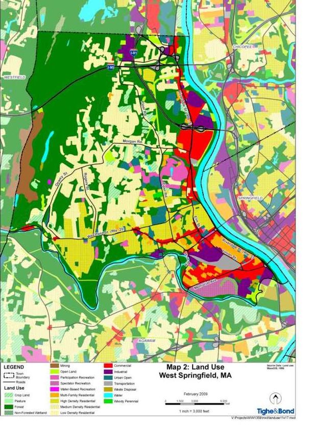
Bear Hole: A locally known geographical area in the northwest section of West Springfield, MA. The
area is approximately 1,700 acres bordered by the city of Westfield and the East Mountain Range to
the west, and the city of Holyoke and Ashley Reservoir to the north.
BEAR HOLE HISTORY
"You have to know the past to understand the present." 1 - Dr. Carl Sagan
Geology, in its very simplest definition means to study the earth. So, as Mr. Sagan insinuated, to understand
current land uses, one must have a basic understanding of past events. In the case of the Bear Hole section of
West Springfield, this guide will initially and briefly consider historic geological events and how they are
responsible for the more recent and relatable history of Bear Hole involving farming, industry and recreation.
Each of these land uses was fully exploited at various times by area inhabitants including Native Americans, early
Colonists and current area residents.
The first event occurred some 65 million years ago during the Mesozoic Era when steep asymmetrical hills were
formed by sheets of lava. Although somewhat scientifically simplified, basically these lava sheets led to the
creation of some small locally known mountain ranges such as Pocumtuck Ridge, Holyoke Range, Mount Tom,
Provin Mountain and East Mountain. Note that time, erosion, and continental shifts also played a role in the
development of the local mountains.
Nonetheless, collectively, these local ranges are part of what is referred to as the Metacomet Ridge; a narrow
and steep mountain ridge known for its extensive cliff faces, scenic vistas, microclimate ecosystems, and
communities of plants considered rare or endangered. A geological map shows the West Springfield and
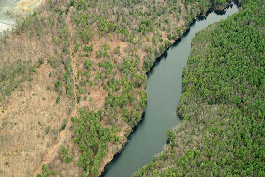
Holyoke portion of the Metacomet ridge and “traprock” in purple (See fig. 2). Note the Bear Hole Reservoir
located just east of this ridge.
Although “traprock” will be discussed in more detail later on in this guide, Merriam Webster defines traprock as
any of various dark-colored fine-grained igneous rocks (as basalt) used especially in road making. 2
1
Tor.com, Exploring Carl Sagan’s Cosmos: Episode 2, “One Voice in the Cosmic Fugue", accessed July 16, 2013,
http://www.tor.com/blogs/2012/11/exploring-carl-sagans-cosmos-episode-2-once-voice-in-the-cosmic-fugue
2
"Traprock." Merriam-Webster.com. Merriam-Webster, n.d. Web. 9 Aug. 2013. http://www.merriamwebster.com/dictionary/traprock
2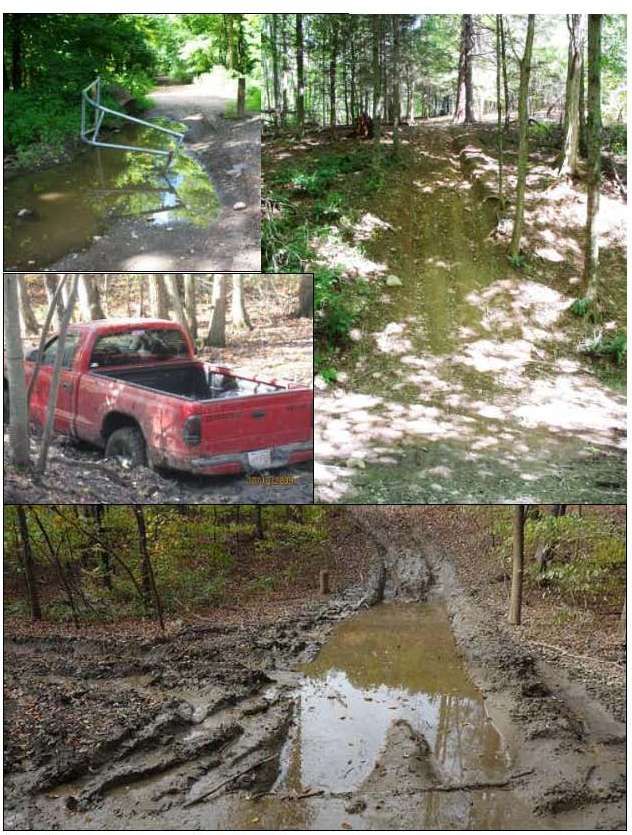
Figure 2. Metacomet Ridge serving as border between West Springfield and Westfield. Bear Hole Reservoir located
just west of the ridge.
Another important geologic event that shaped  today’s  landscape  features, was the formation and ultimate
retreat of glacial Lake Hitchcock. Approximately 20,000 years ago, this region was covered by a massive sheet of
ice called the Laurentide Ice Sheet. As the ice began to melt some 18,000 years ago, a large lake was formed
that extended an estimated 250 miles from what is now central Connecticut northward well into to what is now
Vermont. 3

A map, as provided by the University of Massachusetts Geology Department, shows the likely position
of the lake (See fig. 3). The lake, which remained for approximately 3000 plus years, was formed as a
result of sediment deposits that created a natural dam in the present Rocky Hill, Connecticut area. A
breach occurred about 12,000 years ago and the lake began to drain ultimately forming what is now
the Connecticut River Valley.

These geological events helped create
valuable resources that continue to be
exploited to this day in the Bear Hole
area; namely good soil, water and
rocks. First were the volcanoes that
forced out great flows of lava, which
once cooled turns into basalt or
traprock. Much later, the Ice sheet and
succeeding Lake Hitchcock left
conditions ripe for farming and water
storage, largely due to the various
sedimentation deposits left behind
including clay, sand and gravel.

                                                                    Figure 3. Lake Hitchcock. Figure 50, from Richard D. Little, Dinosaurs, Dunes,
                                                                    and Drifting Continents, p. 61

3
    Dinosaurs, Dunes, and Drifting Continents: the Geohistory of the Connecticut Valley, Richard D. Little, 2nd edition, 1986, p. 107.

                                                                                                                                                     4
Traprock is a dominant feature and a major
                                                                              component of Metacomet Ridge and the western
                                                                              section of Bear Hole. An example of how the ridge
                                                                              appears in the area is shown in Figure 4. Note that
                                                                              this natural resource (traprock) is currently being
                                                                              mined in areas within Bear Hole, yet in other areas
                                                                              a traprock ridges serve as good vista points for a
                                                                              recreational hiking trail.
Figure 4. Typical Metacomet Ridge.

The basaltic rock was also found to work extremely
well for use in ground stone tools. Working with the
rock itself or fastening it to some sort of handle or
strap (a process referred to as hafting) the traprock
could be used for pounding, chopping and grinding
and was thus useful for woodworking, quarrying,
cultivation and processing nuts (See fig. 5).

                                                                                    Figure 5. Example of tools using traprock.
It is believed that both the Native American                                        http://www.uiowa.edu/~osa/learn/ancient/groundstone.html

populations and early European settlers would use the traprock from the nearby ridge in Bear Hole for
many purposes. This view is supported by author Howard S. Russell in his book, Indian New England
Before the Mayflower. In it, he suggests that "...natives might travel miles or trade with tribes far
distant. From outcroppings of flint, slate and traprock they chipped and ground axes, hammers, picks,
hoes, scrappers, mortars, pestles, gouges and similar tools as well as arrowheads and knives..." 4

As will be discussed in this guide, the basaltic rock is also ideally suited for road construction and other
commercial and industrial purposes. Again, the geological formation of traprock and glacial Lake
Hitchcock strongly influenced the historical uses of Bear Hole. Their legacy is also present today as we

4
    Indian New England Before the Mayflower, Howard S. Russell, University Press, 1980, p. 136.
                                                                                                                                          5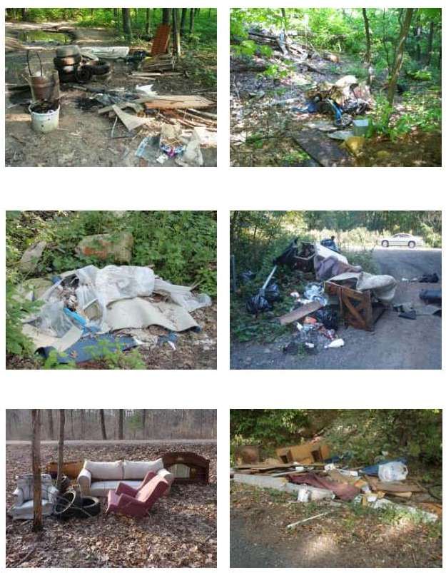
continue to examine the area and its current resources. Without going into a detailed geological
history, it should be noted that these events helped to shape the geographical character of the area.

Over time, much of the rock materials in the area were released through erosion. Significant erosion
and the release of sediments occurred during the last ice age and the melting of the Laurentide Ice
Sheet. Some geologists also refer to this as the Wisconsin Glacial Episode.5 Subsequently, sediments
or  “till”,  comprised  of  boulders,  sand,  gravel  and  clay  were released by the melting process while the
harder  basalt  “traprock”  remained  in  place.    Great  quantities  of  sediments  built  up  in  Connecticut  to
create a dam, which in turn led to the lake's creation. The constant build-up of additional sediments
and water pressure led to the dam's failure and subsequent formation of the Connecticut River Valley.
The drainage of the lake also led to nutrient rich deltas for farming while other deposits helped create
conditions suitable for smaller lakes, ponds, streams and springs. These conditions exist or are in near
proximity of the Bear Hole area.

Although farming no longer occurs immediately within the Bear Hole area, small farms still exist
nearby.    However,  Bear  Hole’s  importance  as  a  source  for  traprock  and  potable water persists. In
addition, the area currently remains well regarded as a popular place to go for hiking, in large part due
to the scenic vistas along the traprock ridge.

Native American Presence

It has been commonly rumored that prior to European settlement, a squirrel could go branch to branch
from the east coast to the Mississippi River without touching the ground. However, in West
Springfield's most notable history book, author Esther M. Swift takes exception. She noted that early
records show that Indians [sic] had always burned off valley lands in the area so that they would be
open for planting corn and for hunting. 6

5
  Surficial geologic map of the Heath-Northfield-Southwick-Hampden 24-quadrangle area in the Connecticut Valley region, west-central Massachusetts:
U.S. Geological SurveyOpen-File Report 2006-1260-G. J.R. Stone, and M.L. DiGiacomo-Cohen, comps., 2010, p. 3.
6
   West Springfield, MA - A Town History, Esther M. Swift, West Springfield Heritage Association; First Edition (1969), p. 38.
                                                                                                                                                      6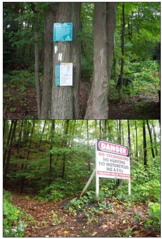
This is likely true for many areas of West Springfield including portions of the Bear Hole area. Evidence
supports this notion. Upland areas that were difficult to cultivate likely remained as woodland area to
support hunting, gathering and wood harvest. However, as was previously indicated, much of the
valley area was ripe for farming as a result of the fine mineral deposits and supporting clay material left
behind from Lake Hitchcock. So, in terms of the Bear Hole area, it seems logical to assume that in the
pre-Colonial period of the early 1600s, both woodlands and open farming areas likely existed.

In regards to the early native populations in West Springfield and the Bear Hole area, there is no clear
agreement in terms of their populations or settlement patterns. Historians tend to agree, however,
that as early European settlers began to take up residence in the Connecticut River Valley area, the
native populations had been significantly reduced by disease and wars with other tribal groups.
Estimates vary, but Ms. Swift contends that by 1635 there may have been as few as 5,000 native
peoples left throughout all of New England. 7 Again there seems to be a little disparity on this issue as
Howard S. Russell's book stated, "Considering all the data and disregarding published estimates that
appear improbable, we judge that a total of at least 60,000 natives in what are today the three
southern New England states and New Hampshire.”  8

Nonetheless, in the early 1600s, historians agree that there were small remnants of larger tribes that
existed west of the Connecticut River. The native groups thought to inhabit the West Springfield area
were either the Agawam or Woronoco tribes; both considered to be a smaller subset of what was likely
the Pocumtuc confederacy. This is supported by surveys conducted by the Massachusetts Historical
Commission (MHC) for both West Springfield and Westfield. The West Springfield survey reported:
             West Springfield contained a diversity of natural resources capable of supporting a large
             native population. Excellent agricultural land occurred throughout all but the
             westernmost  portion  of  the  town…    Native  fishing  was  probably  concentrated  at
             Mittineague Falls and the confluence of the Connecticut and Westfield Rivers. Local
             production of native ceramics would have been facilitated by the large source of clay
             situated in the vicinity of the hill adjacent to the westernmost portion of Westfield
             Street. West Springfield and Agawam (to the south) likely functioned as a major fishing
             and agricultural area for the Connecticut River Valley study unit natives. By the early

7
    West Springfield, MA - A Town History, Esther M. Swift, West Springfield Heritage Association; First Edition (1969), p. 11.
8
    Russell, p. 27.
                                                                                                                                  7
17th century, West Springfield appears to have been included within territory controlled
by the Agawams, a group centered in Agawam, probably until ca.1660. Regional
affiliation was less clearly defined... Considerable evidence of native occupation survives,
exemplified in the several native place names (e.g. Mittineague, Tatham or "Tattom")
and the trail network remaining in West Springfield. 9
The Westfield historical survey reports the following:
Westfield was probably a major native settlement area in the Connecticut River Valley
study unit when considering the extensive freshwater sources and agricultural land. This
area was reputed to be the central location of the Woronocos, a sub-group of the
Pocumtucks, who by the 17th century loosely controlled territory encompassing most of
the westernmost quarter of Massachusetts and extending south and north along the
Connecticut River into northern Connecticut and southern Vermont, respectively.
Material recovered from the Guida Farm site suggests local trade ties with natives
inhabiting the Hudson River Valley (New York) and the southern portion of the
Connecticut River Valley (Connecticut)... In addition, the Little River lowlands and
terrace, the Pequot Pond complex and moderate uplands adjacent to West Farms and
Wyben should be considered archaeologically sensitive… During this period, native
settlement probably concentrated on the lowlands and terraces adjacent to the
Westfield and Little rivers, as suggested by the presence of the above sites and the large
number of unidentified native sites situated near these rivers. Moderate to extensive
native settlement probably occurred on the lowlands adjacent to the Pequot Ponds
complex and the moderate uplands in the vicinity...10
It is worthy to include both the West Springfield and Westfield historical reports when considering the
imprint of native populations in the Bear Hole area. Given the information available, it is likely that
Agawam and Woronoco tribes comingled in the Bear Hole area based on proximity of the geographical
features mentioned in each report.
9
MA Historical Commission (MHC) Reconnaissance Survey Town Report, West Springfield, 1982, p.3.
10
MA Historical Commission (MHC) Reconnaissance Survey Town Report, Westfield, 1982, p.4.
8In supporting West Springfield’s
survey and the presence of the
Agawam tribe in the area, note
that the Paucatuck Brook flows
through the Bear Hole area and
empties in the river near the
“Mittineague (Agawam) Falls.”
Conversely, the Westfield survey
discusses the Woronoco tribe
more predominantly. Note that
Pequot Pond, part of Hampton Figure 6. Pequot Pond as seen from Bear Hole/Metacomet Ridge. May 2013 photo.
Ponds, is located approximately
one mile northwest of the current West Springfield border and Bear Hole area. The ponds can be
clearly seen from higher elevations of the Bear Hole area as shown in Figure 6.
The natural resources provided in Bear Hole were more than likely utilized by both tribes; woodlands
for foraging and hunting; traprock for tools; springs, steams and ponds for both fishing and drinking
water; and abutting areas for farming.
Furthermore and in support of the shared area, some suggest that these native populations did not
situate themselves year round in the same precise locations. Another report compiled by MHC
suggests that native populations would shift their villages or at least move about the region based on
the time of year and available food sources.
During the Contact period, native core areas appear to have been focused along a single
major waterway (the Connecticut River) and its tributaries. These riverine core areas
were the center of a native settlement and subsistence system which connected sites in
the Valley with secondary, seasonally occupied sites in the adjacent uplands. Movement
between the Connecticut River Valley and the interior probably followed a pattern …
Occupation of the riverine villages was heaviest during the winter months, when
occupants subsisted on food reserves accumulated during the spring and fall consisting
of wild game, fish, crops and nuts. This diet was probably supplemented with game and
9fish caught in interior woodlands and ponds by males of the village during the winter.
March signaled movement to major and secondary falls in time for the spawning runs of
anadromous fish such as alewives, and later, shad and salmon. The later spring months
were spent preparing and planting horticultural plots. During the summer, native
settlement focused in the vicinity of these planting fields. During the late summer
women gathered various plants and herbs. Fall subsistence activities involved
harvesting, drying and storing horticultural products as well as extensive hunting. The
only year round occupants of the village sites during this period were probably the aged
and children. With the onset of winter began a new subsistence/settlement cycle.11
Nonetheless, the evidence of native populations in and around Bear Hole is clear. Their presence is still
felt today by the names left behind in the area such as Paucatuck, Agawam, Mittineague, Metacomet,
Massasoit, Pequot, Tattom (Tatham), etc. As previously stated, Pequot Ponds are located just
northwest of Bear Hole. The current Mittineague section of West Springfield provides a contiguous
corridor of streams and woodlands from Bear Hole southward to the Westfield River. Tatham, the
native term for “brook”, is in actuality, part of Mittineague. Metacomet is part of a hiking trail which
traverses through the western section of Bear Hole. The trail was likely part of a foot path used by the
native peoples as well. Massasoit was the name of an Indian chief from the Rhode Island area, and
also chosen as the name for a natural spring that developed in Bear Hole. Paucatuck Brook is within
the heart of the Bear Hole and continues to be a vital resource for the community.
Although the native legacy in and around the Bear Hole area is indisputable, the origin and true
meaning of some of these terms is not easy to trace down and could be an interesting toponymic study
of its own. (Toponymy: research of place-names of a region or language or especially the etymological
study of them).12 In fact, historians do not always agree with the meaning and origin of some native
terms. In Charles H. Barrows, An Historical Address of May 26, 1911, he examines some of the
Springfield area native terms and their meaning. Paucatuck is one word where the meaning does not
have a clear consensus. Barrows refers to another historian's interpretation as follows, "Trumbell is
rather insistent that tuck refers to a tidal river, and admits that while this meaning is applicable to the
11
Historic & Archeological Resources of the Ct. River Valley, MHC, A Framework for Preservation Decisions, 1984, p. 36.
12
"Toponymy." Merriam-Webster.com. Merriam-Webster, n.d. Web. 10 Aug. 2013. http://www.merriam-
webster.com/dictionary/toponymy
10Paucatuck of Connecticut, it does not explain Paucatuck Brook of West Springfield." 13 Nonetheless,
Barrows offers a good start for someone wishing to investigate native terms as he dedicates an entire
section on the subject as part of Appendix A: Meaning and Derivation of Indian Place Names of Old
Springfield. Agawam, Mittineague, Tattom and Woronoco are other terms he offers some insight
about.
To finalize the point of Native America presence in the Bear Hole area, some of these geographical
features and names appear in a Map entitled “Indian Trails About Springfield”, which illustrates likely
movements of native populations about the area in the early to mid 1600s (See fig. 7).
Figure 7. Indian Trails About Springfield, Edwin Online, http://edwin.westath.org/items/show/135.
13
An Historical Address, Charles H. Barrows, Ct. Valley Historical Society, 1916, p. 16.
11Contact Period and Economic Expansion
Those familiar with local history will recall
that English Colonist William Pynchon is
recognized as the European founder of
Springfield, Massachusetts, and by default
West Springfield. Pynchon is recognized as
having successfully negotiated the purchase
of Springfield area lands in 1636. Hampden
County Records has preserved the deed when
“certain lands on both sides of the Great
River” were sold from local Indians to William
Pynchon (See fig. 8).
This leads to the colonial settlement of the
Bear Hole area. Once a formal agreement
with the native populations took place, land
grants on the west side of the river increased
rapidly. Although records were poorly
maintained, there is also anecdotal evidence
that suggests shortly after the West
Springfield settlement, some of the sons of
early "west siders" began to seek land of their
Figure 8. Pynchon Deed with local Indians.
own and looked towards the Bear Hole area to
get it. Swift reports, “In 1665 is found the first record of land granted to sons whose fathers already
had homes west of the river.” 14 During this early period, West Springfield’s MHC reconnaissance
survey also reports, "West Springfield functioned primarily as a resource area, along with Agawam, for
14
Swift, Pg. 22.
12the colonial community of Springfield. There is good probability of the extant period archeological sites
occurring in the vicinity of the northern half of Riverdale Street and Paucatuck Brook.”15 Again, Swift's
research supports this as she states, "During this period in the middle of the 17th century a good many
more home lots were granted on the west side of the river... as far west as Paucatuck Brook;" 16 the
heart of Bear Hole. Perhaps Swift's assessment was ascertained from another historical address
delivered by William Buell Sprague on December 2, 1824. In his address, Mr. Sprague discussed the
settlement of West Springfield as follows; "It is impossible to ascertain, precisely, at what period the
settlement, on this side of the river, commenced; though it was probably as early as 1654, or 55; as
there were, in those years, a number of house lots granted...about the year 1660. Within a few years
after this, there were grants of house lots in various places; some as far west as Paucatuck Brook. 17
The most concise account of early colonial settlement of the Bear Hole/Paucatuck area is established
by J.N. Bagg in an "Account of the Centennial Celebration of the Town of West Springfield, Wednesday,
March 25, 1874." In his compilation of the event, Bagg details the challenges of Bear Hole area's first
settler, Benjamin Smith:
... on the 7th of September 1688, when he was thirty years of age, he purchased of John
Pynchon of Springfield, several tracts of land in West Springfield, at a place called by the
Indians " Pauquetuck," where he commenced the cultivation of the rich intervale land
there bordering on the Westfield river, but fearing the consequences of this interference
with the aboriginals in the priority of occupation, he wisely, continued his home in
Westfield for a year or two, cultivating his land during the summer season, and returning
to Westfield every night. But after a sufficient trial of the good faith of the red-skins, he
at length ventured to construct a rude kind of house or fort on the plateau at the foot of
the mountain slope, which he fortified and guarded against their suspected treachery.
Here he made his castle a house of entertainment and protection for the wayward
traveler who might be overtaken by nightfall during his meanderings through this
primeval forest, for the country had no highways nor roads, except the zigzag cart-path
between the trees that led to the Massachusetts Bay, and known as the " Bay path."
Having outlived the feared hostility of the Indians, he was joined by other people,
and to facilitate their settlement there, he constructed a saw-mill on the falls of
" Pauquetuck" brook the foundation timbers of his dam being still embedded in the
15
MHC, West Springfield, p. 5.
16
Swift, p. 21.
17
An Historical discourse delivered at West Springfield, December 2, 1824, William B. Sprague, Goodwin & Co., 1825, p. 24.
13stream, and when the mill went to decay his mill-saw was preserved and is now in
the possession of his great-great-great-grandson in the city of Springfield, and is a
specimen of the rude implements in use seventy years after the landing of the Pilgrims
on Plymouth Rock, that period having elapsed at the time of building his mill.18
Indeed, the westward migration into West Springfield and the Bear Hole area began to take hold
towards the later part of the century as notable West Side names such as Bagg (ancestors of above-
noted author) and Morgan, whose family members are recognized for breeding the Morgan horse.
Again, records of land ownership and granted lots were unclear; however, it is clear that West
Springfield residents were beginning to exploit areas in and around the Bear Hole area for a variety of
purposes. The Swift book along with the accounts of Bagg and Barrows are replete with early Bear
Hole references and grants being offered to local residents to operate mills, farms and possibly even
some mining operations. West Springfield’s MHC reconnaissance survey states that within the Colonial
Period, “A sawmill was probably built on Paucatuck Brook in ca. 1693.”19 In addition, Barrows refers to
a corn mill and ironworks and later a brick kiln in 1793.20 A map from 1857 indicates a Saw Mill and
Paper Mill located on Paucatuck Brook approaching the Holyoke border, which Barrows indicated is
wrongly named Block Brook on the map (See fig. 10). Other similar maps show Grist Mills and Shingle
Mills within near proximity.
The legacy of mill operations is somewhat
assured given the names of some of the
roads in the area; namely Millville Street
and Saw Mill Road. In addition and
supporting the MHC survey, local historians
and environmental groups contend Millville
Street was significant in the town’s early
Foundation
history. According to West Springfield
remnants.
Environmental Committee’s web site, just
Figure 9. Photo taken August 2013 by author.
18
Bagg, Account of the Centennial Celebration of the Town of West Springfield, Wednesday, March 25, 1874.
19
MHC, West Springfield, p. 6.
20
Barrows, p. 64.
14off of Millville Street “was the site of a 1690’s sawmill built on a waterfall just south of the Great Pond”
(a reference to Ashley Pond later to become part of Ashley Reservoir). Remnants of the dam and the
stone foundations of the mill and related buildings are still visible at “the upper falls of Paucatuck
Brook” and can be located by walking along the former Millville Street and listening for the sound of
the water fall (See fig. 9).
Figure 10. West Springfield, 1857, by H.F. Wailing.According to the group, the waterfall area was part a large complex from 1700 to 1900 that included
the sawmill, a grist-mill, iron works, shingle mill and even a hydraulic cement mill which appeared on
various County and State maps at different times. Note that although Millville Street is not accessible
now and does not appear on a current street list, older records show it in the north central location of
Bear Hole and as the travel road to Ashley Pond/Reservoir in Holyoke. Saw Mill Road is located just
east of the Bear Hole area.
By the mid 1800s, the geological resources previously mentioned are beginning to come to the
forefront of interest to local residents. Farming is extremely productive and profitable due to the rich
soils and availability of water. Quarry and mining operations other than traprock also begin to develop
in Bear Hole. According to MHC's survey, brownstone which is reddish brown sandstone used for
building,21 emerges as another important product for the town.
In the 1840s, before the extensive development of the East Longmeadow quarries, the
Bosworth Quarry in the northwest corner of the town employed 40 men quarrying
brownstone. The value of the stone quarried in 1845, $60,000, represented 79% of the
building stone produced in the entire Massachusetts portion of the Connecticut Valley.
Not long after, the quarry appears to have become inactive, and not until the 1890s are
there further references to quarrying.22
Although detailed information about the West Springfield brownstone operation could not be
obtained, acclaimed Amherst College Geologist Edward Hitchcock, for which Lake Hitchcock was
named, reported its presence in an 1861 report; "Another variety of new sandstone, quarried in many
places in Massachusetts and Connecticut, is coarser than the Longmeadow stone; but being harder is
more enduring, though less elegant. This variety is quarried extensively for the Farmington Canal, in
the sandstone range south of Mount Tom in West Springfield."23 Peripheral research also revealed that
a great many properties throughout New England were constructed with the rock material. One
possible location are The Brownstones, located at 163 West Springfield Street, Boston, MA. Although
no information could be found to corroborate that the material used at this Boston location was mined
from West Springfield, a commercial web site noted that, "During the Triassic period, large deposits of
21
"Brownstone." Merriam-Webster.com. Merriam-Webster, n.d. Web. 24 Aug. 2013. http://www.merriam-
webster.com/dictionary/brownstone
22
MHC, West Springfield, p. 10.
23
Final Report on the Geology of Massachusetts, Edward Hitchcock, Published by J.H. Butler 1861, p.180.
16sandstone were made along the present-day Connecticut River Valley running through Connecticut,
Massachusetts, and New Jersey. Its abundance, low mining cost, visual appeal, and proximity to
Baltimore, Boston, and New York City make it easy to see why it was being used as a building material
in these areas." 24
It is generally presumed that West Springfield brownstone mining ended as the material was running
out and new mines were established in the neighboring town of East Longmeadow. In addition, and as
indicated in that same article, brownstone was falling out of favor as a good material to construct
buildings as the rock is porous and breaks down easily in harsh New England weather conditions. A
map as prepared by Brooklyn College Geology Department depicts the location of the region's
sandstone material (See fig. 11). Note the sandstone runs aside the trap ridge as previously depicted in
Figure 2.
(Figure 2 repeated.) Note the
sandstone alongside the Traprock in
Bear Hole.
Figure 11. Map of Brownstone formations in northeast U.S., and along the Connecticut River Valley.
http://academic.brooklyn.cuny.edu/geology/powell/613webpage/NYCbuilding/PortlandBrownstone/PortlandBrownstone.htm
As was implied, brownstone mining operations in Bear Hole were presumed to be relatively short-
lived. However, more significant and long lasting quarry operations would reappear in the late 1800s
24
Zimbio.com, A Brief History of the Boston Brownstone, August 28, 2007,
http://www.zimbio.com/Home+Repairs/articles/9/Brief+History+Boston+Brownstone, accessed August 23, 2013 .
17in Bear Hole. Traprock was beginning to get exploited for various uses and its availability was aided by
the introduction of rail lines in the area. The expansion of railroad service and the tracking of various
ownerships is extremely complicated. However, evidence shows the Holyoke and Westfield Railroad
Company incorporated in 1869 and approximately 10 miles of track was installed traversing from
Westfield to Holyoke; approximately half of which traveled though West Springfield's Bear Hole area.
A rudimentary plan showing the course of travel is available through the State Library of
Massachusetts (See fig. 12). Note Millville Road is centered within the span.
Figure 12. Holyoke and Westfield Railroad.
Soon after the rail line was built, the newly formed Holyoke and Westfield Railroad Company sold
shares to The New Haven & Northampton Company, as evidenced by a copy of a certificate executed
June 10, 1871 (See fig. 13). Library archives also reveal that the state approved the sale of shares to
the town of Holyoke in 1873 in accordance with MGL Chapter 169, sections 1 and 2.25 Note that the
railroad, which will be discussed later in this guide, appears to have changed ownership many times
over the subsequent years either through mergers or purchase. Many recognize the Boston and
Albany as a long time owner of the local railroad. The point is, in the later part of the 1800s, the rail
lines helped the local industry in the area as well as provided an ideal way to haul the heavy rock
25
The State Library of Massachusetts, http://archives.lib.state.ma.us/actsResolves/1872/1873acts0170.pdf
18material out of the area to be used for the construction of other railroads and new road projects,
which were just being established.
Figure 13. Holyoke and Westfield Railroad Co. Certificate of Shares sold to New Haven & Northampton Co.,
It is believed the first traprock quarry was also located near the other industrial properties off of
Prospect Avenue or Millville Road. A Commemorative History of the Lane Corporation, published by
the John S. Lane Corporation, hints of its location. An excerpt from the document recalls the memory
of Mr. William E. Sikes who began his road building career in 1896;
An early history of the company is found in diaries kept by William E. Sikes. Mr. Sikes
began his career in road building in 1896, right out of high school, working for John S.
Lane and Son on a mile and a half of water-bound macadam, the first state road to be
built in West Springfield, Mass., under the supervision of the newly formed Mass. Dept.
of Public Works. “We spread most of the stone dust required for the top course from the
rear end of high wheeled two-horse dump carts. My wage was 15 cents an hour, which
was the prevailing rate then and we worked a 10-hour day. The broken stone and rock
was hauled from the original Lane quarry located on the main line of the Boston and
Albany RR about three miles away.26
26
The Lane Construction Corporation, A Commemorative History, Published by Lane in 2002, p.2
19It is not clear why this location was abandoned. However, around the same time recalled by Mr. Sikes,
a 1902 property map was developed by the Tourtelotte family, who will be discussed later in greater
detail (See fig. 14). The map clearly depicts the New England Trap Rock Company near Prospect Road
and relatively new railroad. Although unknown to this writer, the trap rock operation shown on the
map could be a competing interest or one and the same as referred to by Mr. Sikes.
Figure 14. New England Trap Rock Co. Map provided by the West Springfield Historical Commission.
Around the same time, the Massachusetts Highway Commission reported on the progress of a road
being developed from Springfield to Pittsfield, MA, which is presumed to be what is now U.S. Route 20.
The Commission's 1896 report stated,
20" This is another part of the road leading from Springfield to Pittsfield, up the Westfield
valley. This was a road very difficult to travel in the spring, on account of the soft
material in the road bed. One mile has been laid out, a portion of which is completed;
work having been commenced too late in the season to admit of completing the contract
this fall. The town of West Springfield is the contractor. The broken stone is local trap
rock from Lane's quarry. The width of Macadam is 18 feet, with gravel shoulders 3 feet
wide on each side." 27
Additional research, particularly the examination of later Highway Commission reports, revealed trap
being supplied by Mr. John S. Lane & Son Company with no further mention of New England Trap Rock.
Regardless, it is clear that extensive trap rock mining operations were occurring at the beginning of the
20th Century; driven by the continued expansion of other railroad lines that needed the rock for track
stabilization and the newly desired roadway mode of travel brought on by a growing automotive
industry. (As a side note, note that Henry Ford's Model A Ford began rolling off the assembly lines in
1902.) Traprock mining continues extensively to this day along the western edge of Bear Hole along
the border of West Springfield and Westfield, with the material being used for roadways.
Bear Hole’s Resort Experience
By the late 1800s, mill operations had given way to two primary uses in the Bear Hole area of West
Springfield: farming and mining. As previously stated, maps and plans of the area clearly depict local
family names scattered about the Bear Hole area as well as locations of former mill operations. Most
used the area for farming and remains of old cellar holes and stone walls throughout the area also
serve to illustrate the area was used for that purpose (See fig. 15).
27
Third Annual Report of the Massachusetts Highway Commission, January 1896, Boston: Wright and Potter printing Co, State Printers, 18
Post Office Square, p. 15.
21Figure 15. Shown are on old stone cellar and stone wall. Photos by author.
However, other uses emerged almost accidentally and partly linked to the country’s new awareness
about various illnesses and diseases. Physical processes can shape land uses, but so can social
processes. Taking this into context, one can begin to understand how water became such a critical
issue for the country and for the town of West Springfield. To illustrate the point, consider a Fact
Sheet published by the EPA, “The History of Drinking Water Treatment.” In the paper, the EPA points
out that by the late 1880s, Louis Pasteur demonstrated the “germ theory” of disease. The theory
essentially explained how microscopic organisms could transmit diseases through drinking water. 28
Continued research on the topic proved that particles in source water caused typhoid, dysentery, and
cholera epidemics. As a result, many communities (and certain entrepreneurs) began to look for
solutions to provide clean filtered water.
Taking advantage of the Bear Hole’s geological conditions and the public’s new awareness about
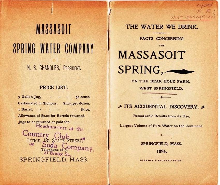
diseases, a savvy businessman in the town of West Springfield sought to capitalize. Mr. N.S. Chandler,
presumably in partnership with property owner Mr. M.L. Tourtellotte, began to market and sell spring
water emanating from within the sandy hillside confines of the Bear Hole area. Sold under the name of
Massasoit Spring Water, the water was touted as clean, pure and with curative properties. In 1896,
under President Chandler’s name, The Massasoit Spring Water Company published a thirteen page
28
The History of Drinking Treatment, U.S. EPA, , February 2000, EPA-816-F-00-006
22marketing pamphlet titled, The Water We Drink – Facts Concerning the Massasoit Spring, on the Bear
Hole Farm, West Springfield * Its Accidental Discovery.
The pamphlet, which has been retained and available for viewing with the West Springfield Historical
Commission, is quite detailed and includes pricing (.50 cents for 5 gallons), its chemical properties and
a series of testimonials from physicians and respected citizens. Below is the cover and back page, a
photograph of the actual spring and another image marketing the availability of the water (See figures
16 and 17).
Figure 16. Massasoit Spring pamphlet. Provided by W.S. Historical Commission.
23Figure 17. Massasoit Spring in Bear Hole.
Again, the marketing of the spring water was clever and relevant to the period as Mr. Chandler enlisted
expert testimonies as well as glowing comments from the press:
A writer in the Springfield Republican speaking of the Bear Hole estate, says: -
This property includes one of the most beautiful glens in the state. Through the hills comes a
broad brook that dashes down the sandstone ledges, forming a series of fine cascades, beneath
a forest shade. Here also wells from the steep hillside beneath the trees, the noble Massasoit
Springs, whose waters are of extraordinary purity and are as full of value as the renowned
Poland, and such is that of Massasoit Springs. - p.10
24Note the tone of the language used in the
marketing material as evidence of the
social concern of the time, even invoking
the Divine (See fig. 18).
As the Massasoit Spring Company was
promoting the virtues of its water, the
property owner and presumed partner of
the spring company were also promoting
what was often referred to as the Bear’s
Den or Bear Hole Resort. Again, an 1893
Springfield Republican news article
preserved by the West Springfield Historic
Commission reports of Mr. Chandler and
Mr. Tourtellotte forming an association to
preserve the Bear Hole area as a local
resort. The tenor of the article indicated
that an outside interest wanted to
purchase the property. However, the local
Figure 18. Massasoit Spring marketing in pamphlet.
men and others indicated their interest in
“preserving it as a family resort during the summer and fall, and preventing it from falling into hands of
parties not connected with this region of country.” 29
Accordingly, the group began to develop the property as a small resort intended to be a quiet retreat
away from downtown West Springfield, where Mr. Tourtellotte owned several other properties. One
may get the sense from reading the historic literature and viewing old pictures that Bear Hole Resort
became a place for some of the area elite to socialize. Again, as described by the Springfield
Republican article,
29
An Attractive Suburban Resort; Bear Hole Picturesque Glen and Plans to Preserve It, Springfield Republican, May 31, 1893, Microfilm
reel #50, Springfield Library, p. 6.
25They have built a strong dam with a road across it and so have created a beautiful quite
pond have a mile long above the cascades on which the visitors row. Also they have
made a good farm out of the wide plain land and have a pretty farm house and ample
barns, with sheds that can accommodate a hundred teams and have been called upon to
do that.” 30
The resort was in keeping with a growing American trend as some people were beginning to
experience more leisure time in part due to automation and a robust economy. Bear Hole Resort was
in fact developed during a period in which Mark Twain satirized as The Gilded Age; a period from 1870
to 1898, which was marked by the growth of industry and wealth which supported materialism.
Alternatively, YourDictionary.com defined it as, “a time between the Civil War and World War I during
which the U.S. population and economy grew quickly, there was a lot of political corruption and
corporate financial misdealings and many wealthy people lived very fancy lives.” 31
The reference of the Gilded Age is merely to frame
the Bear Hole Resort within context of the time.
However, it is hard not to make comparisons
considering the resort came complete with a caged
live bear for the amusement of visitors.
Nonetheless, the resort was believed to be an
attractive and tranquil place with a pond for fishing
and boating, pavilion with a dance floor built and a
restaurant that served soup, fish, lobster, chicken
and steak (See figures 19, 20, and 21).
Figure19. Bear Hole Resort Menu.
W.S. Historical Commission
30
An Attractive Suburban Resort; Bear Hole Picturesque Glen and Plans to Preserve It, Springfield Republican, May 31, 1893, Microfilm
reel #50, Springfield Library, p. 6.
31 "Gilded Age", http://yourdictionary.com/gilded-age, Accessed August 27, 2013.
26Figure 20. Bear Hole Resort
with caged bear attraction.
Photo provided by W.S.
Historical Commission.
Figure 21. Bear Hole Resort Pavilion Structure.
Photos by W.S. Historical Commission.
Interestingly, the Bear Hole Resort was short lived, lasting only from 1890 to 1906. As some were
enjoying the amenities of the resort, town officials in consultation with the Massachusetts Board of
Health, were examining options to shore up the local supply and delivery of potable water.
Correspondence between the town and state officials on January 5, 1905, notes the state proclaimed
the Bear Hole area to be suitable as a long term supply of municipal water:
27... it is probable in the opinion of the Board that a sufficient additional water supply for
the present needs of West Springfield could be obtained from this source... The plans for
developing a large supply from Bear Hole Brook proposed by the engineers who
investigated the question of a water supply for West Springfield five years ago provided
for the construction of a storage reservoir upon this stream holding a little over
300,000,000 gallons and there is no doubt that with such a reservoir an ample supply of
water for the requirements of West Springfield could be made available.32
Although state officials were concerned about the cost of obtaining private properties to protect the
water supply, the town saw Paucatuck Brook combined with local spring water as the best choice to
serve the long term need of safe drinking water for West Springfield residents. Therefore, on March 3,
1906, under the provisions of section 3 of chapter 333 of the Acts of the year 1905, the Massachusetts
Board of Health approved the following:
the taking, for the protection of the purity of certain proposed sources of water supply, of certain
lands located on both sides of Bear Hole Brook in the town of West Springfield, and extending
about 4,800 feet down stream from Massasoit Spring, so called, and upstream to the vicinity of
Bradley Street, about 3,400 feet above said spring, the area to be taken being described in the
application and shown upon plans submitted therewith.33
The taking of Bear Hole property marked a dramatic shift in land uses in the area and thus ended an
extremely diverse history that included industry, quarry operations, and resort activities. The small
dam that helped form the pond was demolished along with the pavilion structures. A large dam was
constructed approximately a mile south of Massasoit Springs and the old resort and Bear Hole
Reservoir was formed. Properties within the immediate vicinity of the reservoir were taken by the
town. Development restrictions also occurred in an expanded area within the watershed. The town
would later purchase other private properties as they became available. The dam had to be rebuilt in
the 1950s after a flood caused irreparable damage; however, the area has remained as a protected
watershed since the original takings.
32
Thirty Sixth Annual Report of the State Board of Health of Massachusetts, Wright and Potter printing Co, 1905, p. 59.
33
Thirty Eighth Annual Report of the State Board of Health of Massachusetts, Boston, Wright & Potter Printing Co., 1907, p. 147
28BEAR HOLE TODAY
People develop a "sense of place" through experience and knowledge of a particular area. A
sense of place emerges through knowledge of the history, geography and geology of an area, its
flora and fauna, the legends of a place, and a growing sense of the land and its history..." 1
- Dr. Thomas A. Woods, President, Making Sense of Place, Inc.
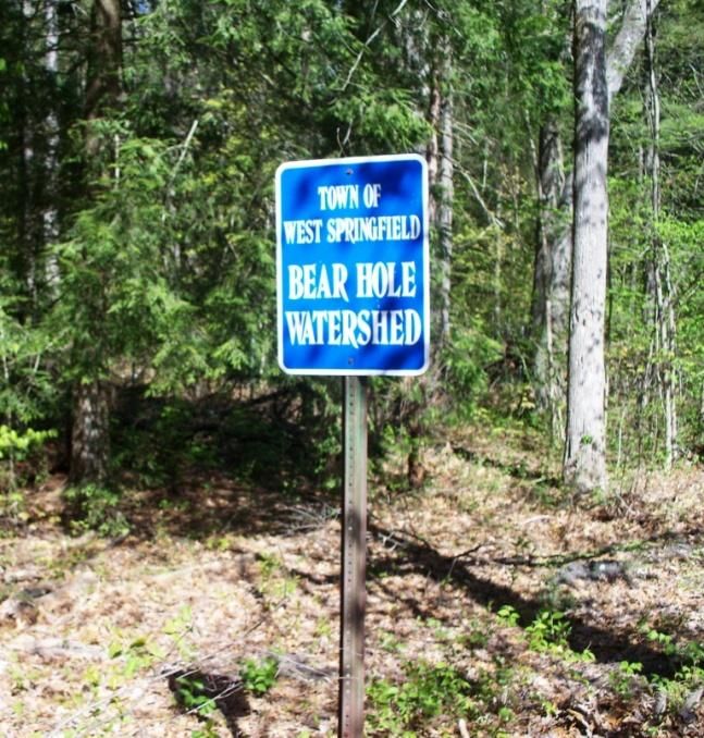
Bear Hole and Bear Hole Watershed
How the name "Bear Hole" came about is somewhat contingent upon who you talk to and what sources
you are referencing. The origin of the term has proved to be illusive and could make an interesting
toponymic study of its own. That said, research indicates that the Bear Hole name is primarily a local
term, but slowly evolving into the state’s lexicon. To many a West Sider, Bear Hole is simply known as
the large wooded section in the northwest portion of the town (technically now a city known as the
Town of West Springfield2). To others, it is the reservoir and the area immediately surrounding the
reservoir denoted by a large stand of planted white pine trees. Those with a greater familiarity of the
area might think of the Bear Hole as being the watershed or that portion within the northwest section of
the community that is owned and controlled by the town and under a conservation restriction.
In fact, there is no clear consensus regarding the actual borders and location of Bear Hole as well as the
origin of its name, which was likely derived based on folklore. Although nothing has been found
corroborating the connection, many believe the Bear Hole name may have been adopted from an
occurrence that was recalled by Mr. Charles Barrows in his 1916 historical address; "…the last bear
known at this place appeared on the Great Plain about 1790 when Seth Smith was there hoeing corn.”3
It was commonly accepted that overhunting, the expansion of farming and deforestation had led to
demise of black bears throughout the area in the late 1700s. Given the apparent rarity of bears in the
area at the time, the sighting was evidently quite the spectacle as reflected in Mr. Barrows address.
However, the first actual reference to the name appears in a deed to Mr. Rufus S. Payne in 1838, which
identified a 132 acre area as Bear Hole.4 This parcel was later to become the location of the resort area
previously described in this guide. So, from an historical point of view, Bear Hole is the tract of land
that became Bear Hole Reservoir and the area immediately surrounding it.
1
Importance of Place, http://www.importanceofplace.com/search/label/Quotes, accessed September 7, 2013.
2
West Springfield Clerk’s Office, http://www.west-springfield.ma.us/Public_Documents/FOV1-00010102/Incorporation
3
An Historical Address, Charles H. Barrows, Ct. Valley Historical Society, 1916, p. 27.
4
Bear Hole Timeline, prepared by Town Historian, Mr. Bernard Lally (d. 2011), West Springfield Historical Commission.
29However, more contemporary
descriptions show or define the area
as a watershed serving the Bear Hole
reservoir. The U.S. Environmental
Protection Agency (EPA) defines a
watershed as, “the area that drains to
a common waterway, such as a
stream, lake, estuary, wetland,
aquifer, or even the ocean — and our
individual actions can directly affect
it.5 A simple example of a watershed
is shown in figure 22. Notice the ridge
line serves as a topographical divide
for rainfall and other forms of Figure 22. Watershed. EPA image,
http://water.epa.gov/type/watersheds/whatis.cfm
precipitation.
The example as shown in figure 1 is a representation of conditions that exist in the Bear Hole area,
which is illustrated in a map prepared by Tighe & Bond Engineers (See fig. 23). Hired by the town to
evaluate existing conditions, the engineers mapped the watershed using geographical contours and
formally named the defined area as the Bear Hole Watershed. Although the name had been used in
previous reports, the map and associated documentation collected by Tighe & Bond defined the
geographical limits of the watershed and estimated the area to be approximately 2.65 square mile or
1,697 acres.6 Like the example, land elevations or topography defined the area as opposed to history
and past uses. The watershed excludes the traprock quarry located just west of the reservoir, wooded
areas just south of the reservoir’s dam, as well as other nearby undeveloped areas. Differences in
elevation and geographical contours (topographical divide) marginalize their contribution to the
watershed, and therefore, are not included. The point is that Tighe & Bond's watershed area excludes a
good amount of acreage that many others would consider to be part of Bear Hole. It should be
recognized that the Bear Hole watershed is in actuality a sub-watershed. Ashley Reservoir, Paucatuck
Stream and Bear Hole Reservoir contribute to a larger watershed referred to as the Westfield River
Watershed (See fig. 24).
5
US EPA, Watersheds, http://water.epa.gov/type/watersheds/index.cfm, accessed August 2013.
6
Comprehensive Interior Roadway Improvement Plan, Bear Hole Watershed, Tighe & Bond, May 2004, pp. 1-3.
30Figure 23. Bear Hole Watershed, Tighe & Bond Engineers, Comprehensive Interior Roadway Improvement Plan, 2004
The map has been modified by this author with inclusion of text boxes.
31You can also read