DISTRICT DISASTER MANAGEMENT PLAN SINDHUDURG - Disaster Management Programme Govt.Of Maharashtra UPDATED MAY 2019
←
→
Page content transcription
If your browser does not render page correctly, please read the page content below
DISTRICT DISASTER          MANAGEMENT PLAN

               SINDHUDURG

                UPDATED
                MAY 2019

DISTRICT DISASTER MANAGEMENT AUTHORITY
               SINDHUDURG

Disaster Management Programme Govt.Of Maharashtra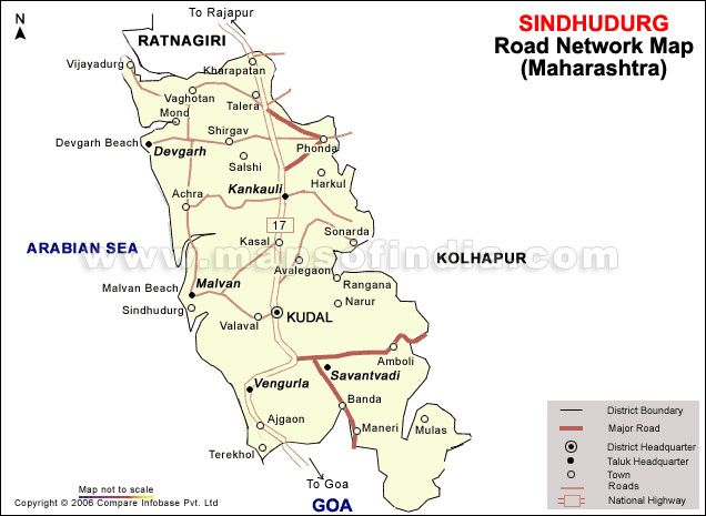
Executive Summary

     The District Disaster Management Plan is a key part of an emergency management. It will play a
significant role to address the unexpected disasters that occur in the district effectively .The
information available in DDMP is valuable in terms of its use during disaster. Based on the history of
various disasters that occur in the district ,the plan has been so designed as an action plan rather than a
resource book .Utmost attention has been paid to make it handy, precise rather than bulky one. This
plan has been prepared which is based on the guidelines provided by the National Institute of Disaster
Management (NIDM)While preparing this plan ,most of the issues ,relevant to crisis management ,have
been carefully dealt with. During the time of disaster there will be a delay before outside help arrives.
At first, self help is essential and depends on a prepared community which is alert and informed
.Efforts have been made to collect and develop this plan to make it more applicable and effective to
handle any type of disaster.

      The DDMP developed involves some significant issues like Incident Command System (ICS),
India Disaster Resource Network (IDRN)website, the service of National Disaster Response Force
(NDRF) in disaster management .In fact ,the response mechanism ,an important part of the plan is
designed with the ICS, a best model of crisis management has been included in the response part for
the first time. It has been the most significant tool to the response manager to deal with the crisis within
the limited period and to make optimum use of the available resources.

       Details of inventory resources are given an importance in the plan so that during disaster their
optimum use can be derived. The resource inventory, the IDRN is now linked with the website which is
vital to cope with the crisis. It will give the detail information to any officer at the time of disaster. He
can view the available resources and order them at the time of disaster. The most necessary equipments,
skilled manpower and critical supplies are included in the inventory resources. During disaster, the
resources from this website can be ordered without delay which will make the response time lesser. List
of medical, doctors, control room of various departments, ambulances, blood banks, public health
centers, and government and private hospitals have been included in this plan. This plan also provides
important list of websites, related to meteorology, earthquake, flood, fire, disaster related training
institutions, available materials etc.

      As a whole, this is a genuine effort of district administration to develop the plan and if you have
any suggestions and comments, be free to convey the same so that we can include them in the next
edition. We are thankful to all the institutions and persons who have provided us the vital information
in time. Also some blank space has been provided wherever possible so that any further new
information can be included as and when required.

                                                     District Collector/Chairman of DDMA
                                                                 Sindhudurg

May 2019
Abbreviations Used in the Document AIR All India Radio BIS Bureau of Indian Standards BSNL Bharat Sanchar Nigam Limited CEO Chief Executive Officer CISF Central Industrial Security Force CRPF Central Reserve Police Force DCR District Control Room DD Doordarshan DDMA District Disaster Management Authority DDMC District Disaster Management Committee DDMP District Disaster Management Plan DHO District Health Officer DICT District level Incident Command Team DMT Disaster Management Team DOT Department of Telecommunication DOP Diversification of Power DRMP District Risk Management Programme EOC Emergency Operation Centre FCI Food Corporation of India GOI Government of India IAP Incident Action Plan ICP Incident Command Post ICS Incident Command System ICT Incident Command Team IDRN India disaster Response network IMD Indian Meteorological Department ITI Industrial Training Institute MERI Maharashtra Engineering Research Institute MIDC Maharashtra Industrial Development Corporation
MPCB      Maharashtra Pollution Control Board
MSEDC     Maharashtra State Electricity Development Corporation
MSRTC     Maharashtra State Road Transport Corporation
MTDC      Maharashtra Tourism Development Corporation
MWSSB     Maharashtra Water Supply and Sewerage Board
NABARD    National Agricultural Bank for Rural Development
NCC       National Cadet Corps
NDRF      National Disaster Response Force
NGO       Non Governmental Organization
NIDM      National Institute of Disaster Management
NSS       National Social Service
PHC       Public Health Centre
PPPP      Public Private Partnership Programme
PWD       Public Work Department
RCC       Reinforced Cement Concrete
RDC       Resident Deputy Collector
RTO       Regional Transport Officer
SDO       Sub Divisional Officer
SOC       Site Operations Centre
SOP       Standard Operating Procedure
SP        Superintendent of Police
SRP       State Reserve Police
ST        State Transport
TDMP      Taluka Disaster Management Plan
UNDP      United Nation Development Programme
YASHADA   Yashwantrao Chavan Academy of Development
Contents
1. Introduction

1.1     Background

1.2     Need for Disaster management

1.3     What is a Disaster?

               1.3.1 Hazard

               1.3.2 Vulnerability

               1.3.3 Disaster Preparedness

               1.3.4 Disaster risk reduction (DRR)

               1.3.5 Natural hazard

1.4     Worst Disasters in the world

1.5     The Indian Scenario

1.6     National Disaster management Act (NDMA), 2005

1.7     Sindhudurg

1.8     Importance of Multi-hazard Management Plan

1.8.1   The main features of multi-hazard plan

1.8.2 Disaster Management Cycle

               1.8.2.1 Pre disaster activities

               1.8.2.2 Emergency activities

               1.8.2.3 Post disaster activities

               1.8.2.4 Mitigation methods

1.9     Objectives of the Plan

2.      District Profile
2.1     Location and Extent
2.2 Area and Administrative Division
2.3 Socio Economic Features
2.4 Major Historical and Religious Centers
2.5 River Systems and Dams
2.6 Industries
2.7 Transport and Communication Network
2.8 Education
2.9 Tourism
2.10 Geography and Topography
3. Hazard and Vulnerability Analysis
3.1 History of Disasters in Sindhudurg District
3.2 Vulnerability Assessment
4. Institutional Mechanism
4.1 District Disaster Management Authority (DDMA)
4.2 District Disaster Management Committee (DDMC)
4.3 District Control Room
4.4 Communication Mechanism
4.5 Site Operation System during Disaster
4.6 Desk Arrangements in the District Control Room
5. Preparedness and Mitigation
5.1 Preparedness
5.2 Mitigation
5.3 Preparedness and Mitigation Measures
5.3.1 General Preparedness Measures
5.3.2 Disaster wise Preparedness Measures
6. Response Plan
6.1 Response Structure during Warning Stage
6.2 Incident Command System
6.3 Role and Responsibilities of ICS Staff
6.3.1 Incident Commander
6.3.2 Information Officer
6.3.3 Liaison Officer6.3.4 Safety Officer
6.4 Role and Responsibilities of ICS General Staff
6.4.1 Operations Section
6.4.2 Planning Section
6.4.3 Logistics Section
6.4.4 Finance / Administration Section
6.5 District Search and Rescue Team
6.6 District Level Medical Team
6.7 Involvement of Defense and Paramilitary Forces
6.7.1 NDRF in Disaster Management
6.8 Temporary Shelter Management
6.9 Relief Management
6.10 Rapid Damage Assessment and Reporting
6.11 Communication
6.12 Law and Order
6.13 Public Grievances / Missing Persons Search
6.14 Animal Care
6.15 Management of Deceased
6.16 NGOs and Voluntary Organizations
6.17 NSS / NCC Students
7. Recovery and Reconstruction Plan
7.1 Post Disaster Reconstruction and Rehabilitation
7.2 Administrative Relief
7.3 Reconstruction of Houses Damaged / Destroyed
7.4 Military Assistance
7.5 Medical Care
7.6 Epidemics
7.7 Corpse Disposal
7.8 Salvage
7.9 Outside Assistance
7.10 Special Relief
7.11 Information
7.12 Social Rehabilitation
8. Standard Operating Procedures
8.1 Standard Operating Procedures of various Departments
8.1.1 Revenue Department8.1.2 Police Department
8.1.3 Health Department
8.1.4 Water Supply Department
8.1.5 Irrigation Department
8.1.6 Agriculture Department
8.1.7 M.S.E.D.C.
8.1.8 Public Works Department
8.1.9 Telephone Department
8.1.10 Animal Husbandry Department
8.1.11 State Transport Corporation
8.1.12 Forest Department
8.1.13 Port Office
8.2. Checklist of Various Departments
8.2.1 District Collector
8.2.2 Police Department
8.2.3 Health Department
8.2.4 M.S.E.D.C
8.2.5 Water Supply
8.2.6 Irrigation
8.2.7 Telephone Department
8.2.8 Public Works Department
8.2.9 Agriculture
8.2.10 Animal Husbandry
9. Monitoring, Evaluation and Funds
9.1 Plan Evaluation
9.2 Plan Update
9.3 Budget and other Financial Allocations
9.4 Linking with the Development Plans
10. Important Phone Numbers
Control Rooms of Major Departments
MP and MLA, Sindhudurg
Revenue and Police Control Rooms at Taluka Level
1. Key Officers in the District2. List of Deputy Collectors 3. Key Officers of jilha Parishad , Sindhudurg 4. Tahsildars & RNTs 5. Block Development Officers (BDO) 6. Nagar Parishad Officers 7. Dy. Engineer, PWD (Zilla Parisad) 8. Dy. Engineers (Minor Irrigation, ZP) 9. Dy. Engineers (Rural Water Supply, ZP) 10. Major District Level Departments & Telephone Nos. 11. Railway and Bus Stations 12. Konkan Railways 13. List of Govt. Hospital in the District 14. Govt. Ambulance Services 15. Private Ambulance Services 16. List of Blood Banks 17. Fire Stations 18. Police Stations 19. Municipal Councils 20. List of Private Hospitals 21. - List of Veterinary Hospitals 22. List of Primary Health Centre
23. Jilha Parishad Dispensaries

24. Emergency Medical Team

25. List of Medicine Stockist in the District

26. List of Inflatable Rubber Boat Operators

27. Volunteers in Flood Prone Villages Trained in Search & Rescue

28. List of Swimmers

29. List of NGOS in Disaster Management

30. List of Co-operative Societies in the District

11. ICS Glossary

12. List of Websites

13. Most IMP contact numbers

14. Resource Inventory (IDRN)

    List of Websites
1. INTRODUCTION
1.1 Background
Natural Disasters are known to mankind before it evolved and will happen afterwards also. It
reminds us of a meteorite that had hit the earth which eventually wiped off the entire dinosaurs,
million years ago. Today, also we witness them in the form of Earthquake, Floods, Landslides,
Cyclones, Wildfires, Avalanches, Cloudburst, Heat and cold waves and the tsunamis (giant tidal
waves). Many countries have suffered loss of human lives and damage to property; their
economic losses have been in million dollars. Thus, disasters not only kill people, but also have
tremendous effect on economy. It enhances the poverty of an already poor country and makes it
impoverish. In disasters, it is the poor and under privileged, who are the worst affected, they tend
to lose their shelter, livelihood and become more impoverished.
1.2 Need for Disaster management
Data on disaster occurrence, its effect upon people and its cost to countries, are primary inputs to
analyze the temporal and geographical trends in disaster impact. Disaster losses, provide the
basis for identifying where, and to what extent, the potentially negative outcomes embedded in
the concept of risk is realized. They help to understand where, and to whom, disaster risk
becomes impact. They also provide the basis for risk assessment processes, a departing point for
the application of disaster reduction measures. – UN ISDR
Development cannot be sustainable unless disaster mitigation is built into development process.
Investments in mitigation are more cost effective than expenditure on relief and rehabilitation.
Prevention and mitigation contribute to lasting improvement in safety and are essential to
integrated disaster management. Disaster response alone is not sufficient as it yields only
temporary results at very high cost. So emphasis must be on Disaster prevention, mitigation and
preparedness, which help in achieving objectivity of vulnerability reduction.
1.3 What is a Disaster?
“A Disaster is a sudden, calamitous event that causes serious disruption of the functioning of a
community or a society involving widespread human material economic or environmental losses
and impacts which exceeds the ability of the affected community or society to cope using its own
resources.”
---- UN International Strategy for Disaster Reduction, (UNISDR)
A Disaster is a "Situation or event, which overwhelms local capacity, necessitating a request to
national or international level for external assistance; an unforeseen and often sudden event that
causes great damage, destruction and human suffering".
----- Centre for Research of Epidemiology of Disaster (CRED), Belgium
1.3.1 Hazard: is a natural physical event which has a potential to convert into a disaster,
causing widespread injury or deaths and damage to public or private property or the
environment.1.3.2 Vulnerability: means inability to resist a hazard or respond when a disaster has occurred.
It depends on several factors such as people’s age and state of health, local environmental and
sanitary conditions, as well as on the quality and state of local buildings and their location with
respect to any hazards. --- UNISDR
1.3.3 Disaster Preparedness
Pre-disaster activities that are undertaken within the context of disaster risk management and are
based on sound risk analysis. This includes the development/enhancement of an overall
preparedness strategy, policy, institutional structure, warning and forecasting capabilities, and
plans that define measures geared to helping at-risk communities safeguard their lives and assets
by being alert to hazards and taking appropriate action in the face of an imminent threat or an
actual disaster.
--- Office of Commissioner for Humanitarian Affairs (OCHA)
1.3.4 Disaster risk reduction (DRR), attempts to look back at the root causes of risks and
vulnerabilities in a society, state, town or even a single household. Factors can be broad or
specific, depending on the scope of risk and vulnerability assessments.
1.3.5 Natural hazard: Natural process or phenomenon that may cause loss of life, injury or
other health impacts, property damage, loss of livelihoods and services, social and economic
disruption, or environmental damage.
The Natural disasters were split into 3 specific groups:
1. Hydro-meteorological disasters: Floods and wave surges, storms, droughts and related
disasters (extreme temperatures and forest/scrub fires), and landslides & avalanches;
2. Geophysical disasters: Earthquakes & tsunamis and volcanic eruptions;
3. Biological disasters: Epidemics and insect infestations.
1.3.6 Man made disasters
Disasters due to human activities could be unintentional, but lack of safety measures and abiding
by certain safety rules and regulations, . Most of these (barring coordinated terrorist activities)
are due to certain accidents.
Terrorism, Bomb blast, Wars, Riots, technology related, Accidents (Road, Ship, Air), Chemical
and Nuclear, Industrial accidents etc.
1.4 Worst Disasters in the world
1. Bam earthquake, Iran, Dec 2003, magnitude 6.6 and 26,271 dead, 30,000 injured
2. South Asian tsunami, Dec 2004, magnitude 9.3 and 230,000 dead in 14 nations, 125000
injured, 45,752 missing and 1.69 million homeless
3. Sichuan earthquake, China, May 2008, magnitude – 7 and 8 69,195 dead, 18,392 homeless
and 374,643 injured and 115 billion dollars loss4. Haiti earthquake, Jan 2010, magnitude 7 and 150,000 dead, 300,000 injured and 100 million dollars loss 5. Pakistan floods, Jul 2010 --- 2,000 dead, 20 million affected and loss of 43 billion dollars 6. Japan tsunami, Mar 2011, magnitude 9 and 15,188 dead, 5,337 injured, 8,742 missing and loss of 300 billion dollars 1.5 The Indian scenario India has been vulnerable to many disasters in the past both natural and man made. Nearly, 60% of the landmass is prone to earthquake, 8% for cyclones (east and west coast) and 68% for drought. Some of them are mentioned below along with number of people dead and the economic losses incurred. A. Natural disasters in India 1. Latur earthquake, Sept. 1993, magnitude 6.4 and 20,000 dead and 30,000 injured 2. Orissa super cyclone, Oct 1999, 15,000 dead 275,000 homes destroyed and 8,119 injured and 4.9 billion dollars loss 3. Gujarat earthquake, Jan 2001, magnitude 7.7 and 20,000 dead and 167,000 injured and 400,000 homes destroyed and 5.5 billion dollars loss 4. South Asian Tsunami, Dec 2004, magnitude 9.3 and 12,405 dead, 5,640 missing and 647,599 homeless. 5. Cyclone Aila, 25 May 2009, 325 dead and 8,000 missing, one million homeless and loss of 552.6 million dollars and 7,000 infected with diarrhea due to floods B. Man made disasters in India 1. Bhopal gas tragedy, Dec1984 and 3,787 dead and 558,125 affected with disabling injuries. 2. Gujarat riots, Mar 2002 3. Serial bomb blast, Mumbai, Mar1993 4. Bomb blast in suburban trains, Mumbai, Jul 2006 5. Terrorist attack, Mumbai, Nov 2008 6. Air plane accident, Mangalore, May 2010 Thus, we can notice that most of the disasters have occurred within the last two decades, and the frequency, intensity and magnitude of the disasters are ever increasing. 1.6 National disaster management (NDMA) Act, 2005 The National emergency management authority was constituted in Aug 1999, which submitted a report in 2001, to have separate department for Disaster management in India Government enacted the National disaster management act on 23rd Dec 2005, which lead to the creation of National disaster management authority (NDMA).
Nodal ministries responsible for various categories of disasters

1. Earthquakes and Tsunami                    MHA/Ministry of Earth Sciences/IMD
2. Floods                                     MHA/Ministry of Water Resources/CWC
3. Cyclones                                   MHA/Ministry of Earth Sciences/IMD
4. Drought                                    Ministry of Agriculture
5. Biological Disasters                       Ministry of Health and Family Welfare
6. Chemical Disasters                         Ministry of Environment & Forests
7. Nuclear Disasters                          Department of Atomic Energy
8. Air Accidents                              Ministry of Civil Aviation
9. Railway Accidents                          Ministry of Railways
10. Terrorism, bomblast, Riots                Ministry of Home Affairs

1.7 Sindhudurg

Sindhudurg is one of the disaster prone districts in Maharashtra having 121 kms. coastal line.
Occasional Cyclones (Cyclone Phyan in Nov 2009), Floods are more common especially in
Malvan, Kudal, Sawant wadi,Vengurla, Dogad and Kankavli due to overflowing rivers. Land
slides are frequent especially in the ghats (Amboli, Karool, Phonda), Road accidents are frequent
on Mumbai Goa highway (National highway no. 17) and due to hair pin bends there are many
accident spots identified and Rail accidents along the Konkan rail, mostly during the monsoon
due to landslide (In Vaibhav wadi near Kharepatan tunnel in Jun 2003) and lastly due to heavy
rain and wind incidents of tree falling are observed. The present Disaster Management Program
which has been implementing by the Government of Maharashtra aims to minimize the risk
caused by unexpected disasters in the district. The Disaster Management Program exclusively
works for developing the disaster management plans, providing trainings, and strengthening the
capacity of the different Disaster Management Teams (DMTs) and creating awareness among
public on various disasters. As it is said that, plan development is one of the vital objectives of
this project much more attention has been paid by the district administration to develop the plan
so that it will be more useful to handle the disasters timely in future. Therefore, genuine efforts
have been dedicated to develop the District Disaster Management Plan (DDMP).
Disaster Management has comprehensive cycle that includes preparedness, response, recovery
and reduction phases. Based on this cycle, the response part is addressed with Incident Command
System, (ICS) a best management tool, and linked with resource inventory connected to website
India Disaster Resource Network, www.idrn.gov.in (IDRN). In fact, ICS and IDRN make it
more effective.
Above all, this plan will be a true guide to a disaster manager at district level, since it provides
all necessary information required for timely and effective response to any unexpected disaster.

Being a coastal district Sindhudurg is largely prone to cyclones and flash floods. Considering
this situation, the District Disaster Management Plan (DDMP) has been developed and covered
all relevant information related to human resources, equipments and critical supplies.
1.8 Importance of Multi-hazard Management Plan
It is apparent that this district is prone to natural disasters such as floods, cyclones, landslides etc.
Also, it cannot ignore the man-made disasters. So the district plan is designed as per the present
need and the major strategies to respond to any unexpected situation have also been considered.

In the multi-hazard district plan, all the disasters will be handled properly following the given
response mechanism, like ICS, use of resource inventory, Standard Operating Procedures (SOP),
keeping coordination with the line agencies and proper community based awareness activities.
SOP of line departments is designed to make them alert. It highlights their role and
responsibilities during, after and normal time of the disaster.

1.8.1 The main features of multi-hazard plan are: -

1. It gives importance to all the disasters equally and helps to mitigate the situation beforehand.
2. All the departments are assigned with their proper role and responsibilities, which are clearly
indicated in the SOPs.
3. The District administration has to be alert round the year as disasters may occur any time,
anywhere in the district, irrespective of time and location.

1.8.2 Disaster Management Cycle

In multi-hazard response plan, the disaster management cycle has a significant role to play. The
four stages of disaster cycle have their own importance in terms of their implementation during,
after and before the occurrence of any disaster.
Disaster

                                        Emergency
         Preparedness
                                        Response            C
R
         Planning
                               D        Immediate relief
         Training                                           R
I                                       Search and Rescue
         Capacity              I
                                        First Aid           I
S        building
                               S
                                                            S
K
                               A
                                                            I
                               S
                                                            S
M
                               T
                                               Recovery
A           Prevention
                               E
                                           Restoration      M
N
                               R
                                                            A
A                                          Rehabilitation
                                                            N
G                                          Reconstruction
                               C
                                                            A
E
                               Y
                                                            G
M
                               C
                                                            E
E
          Mitigation           L
                                                            M
N
    Vulnerability and risk     E
                                              Development   E
T   assessment
    Structural                                              N
    Non structural
                                                            T
1.8.2.1 Pre disaster activities 1. Policy development and National, State, district, local level disaster organization formation 2. Vulnerability and capacity assessment 3. Prevention and mitigation 4. Preparedness, planning and training 1.8.2.2 Emergency activities 1. Warning (beginning before the actual event) 2. Evacuation, search and rescue 3. Emergency assistance (relief) – food, water, shelter, medical aid 1.8.2.3 Post disaster activities 1. Repair and restoration of life lines (power, telecommunications, water transportation) 2. Reconstruction and rehabilitation 1.8.2.4 Mitigation methods i) Structural measures: Any physical construction to reduce or avoid possible impact of hazards, which include engineering measures and construction of hazard-resistant and protective structures and infrastructure. --- NDMA (2005) ii) Non structural measures: Non engineered measures to reduce or avoid possible impacts of hazards such as education, training and emergency planning, capacity development, general public awareness, early warning system, hazard vulnerability risk analysis, communication mechanism etc. --- NDMA (2005) 1.9 Objectives of DDMP 1. To prevent loss of human life and property damage 2. To study, analyze and evaluate the disasters 3. To identify the vulnerable locations and do the vulnerability and risk analysis 4. To improve preparedness, prevention and mitigation at district level 5. To ascertain the status of existing resources and facilities available 6. To recommend appropriate strategies and responses to deal with future disasters
2. DISTRICT PROFILE
2.1 Location and Extent
The earlier Ratnagiri district was divided into two districts, Ratnagiri and Sindhudurg on 1st May
1981 for the industrial and agriculture development of the southern part of the Konkan division.
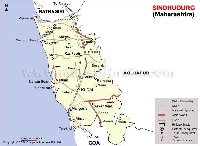
Sindhudurg District is located at the southwest corner of Maharashtra state along with the western coast
in the Konkan region. It is one of the six districts in the Konkan Division along with Ratnagiri, Raigad,
Thane, Mumbai and Mumbai Suburban. It lies between latitudes 15° 40’ to 16° 40’ north and 73° 20’ to
74° 10’ east longitudes.
The district headquarter is at Oras Budruk which lies on the Mumbai Goa Highway and is well
connected by bus routes to the state capital, Mumbai and other major towns in Maharashtra. The state
capital of Mumbai is 550 kms to the north of this district, while Kolhapur is 160 kms to the east,
Ratnagiri 192 kms to the north and Panaji, the capital of Goa is 80 kms to the south.
2.2 Area and Administrative Division
Sindhudurg district covers an area of 5207 km. For administrative convenience, it has been divided
into 3 sub divisions.
Total Talukas – 8, Total Gram Panchayats – 431 Total Revenue villages –752, Total No.Of
Saja - 236 Urban Local Bodies – 8
Sr.No Name of the Sub-division Talukas
1 Sawantawadi Sawantawadi, Vengurla and Dodamarg
2 Kudal Kudal and Malvan
2 Kankavli Kankavli, Deogad and Vaibhavwadi
Sr. Taluka No. of Gram No. of Saja No. of Revenue Villages
No. Panchayat
1 Sawantwadi 63 32 86
2 Kudal 68 36 125
3 Kankavali 63 36 105
4 Vengurla 30 26 84
5 Malvan 65 40 136
6 Deogad 72 33 98
7 Dodamarg 36 13 59
8 Vaibhavwadi 34 20 59
Total 431 236 752
2.3 Socio Economic Features
The total geographical area of the district is 5207 km consisting of 1.69% of the total area of the
state. Area wise, Sawantwadi is the largest tahsil having an area of 1343.9 sq.km. Followed by Kudal
819.5 sq.km. While Vaibhavwadi is the smallest tahsil with an area of 417.7 sq.km.2.3.1 Demographics
Total population(Census 2011) 8,49,651
Total male(Census 2011) 4,17,332
Total female(Census 2011) 4,32,319
Total literacy rate(Census 2011) 85.86%
Female literacy(Census 2011) 79.81 %
Families(Household) (Census 2011) 2,09,839
Schedule Caste Population(Census 2011) 55,586
Schedule Tribe Populations(Census 2011) 6,976
Total BPL families(2002 sourse DRDA) 74,809
2.4 Major Historical and Religious Centres
Kunkeshwar Dewasthan (Deogad), Sindhudurg Fort (Malvan), Bharadi fair (Aanganyachiwadi,
Malvan), Bhavai fair (Sonurli, Sawantwadi), Ghodemukh fair (Sawantwadi), Datta Mandir (Patgaon,
Deogad).
2.5 River Systems and Dams
There are six major rivers in the district.
1. Vaghothan 2.Sukhnadi 3.Tillari 4.Karli 5. Gadnadi 6. Terekhol
1. The Vaghothan river has a course of about 48 kms from the Shivgad pass to it’s mouth which is
protected by the Deogad promontory from the south.
2. Gad River flows in a southwesterly course from the Sahyadris and joins the sea 3 miles north of
Malvan.
3. Karli river is also known as Sarambal in the upper reaches and as Karli only at its mouth.
4. Terekhol in its upper reaches is known as Banda river and in the lower reaches as Terekhol.
Sn Name of the Dam Name of the River Size Status
1 Tillari Tillari Large Complete
2 Talamba Karli Large On-going
3 Deoghar Deoghar Medium Complete
4 Nardawe Gad Medium On-going
5 Sarambal Terekhol Medium On-going
6 Aruna Aruna Medium On-going7 Shirshinge Vaghotan Small On-going
8 Tarandale Terekhol Small On-going
9 Dendonwadi Gad Small On-going
10 Shivdav Gad Small Complete
11 Otav Achara Small On-going
12 Talere Khandara Small On-going
13 Nadhavade Vaghotan Small On-going
14 Nirukhe Karli Small On-going
There are some other rivers such as Kalne river, Kasal river, Kharepatan river, Kalaval river,
Karli and Redi creek.
2.6 Industries
There are 2587 industries situated in 3 Industrial Estates viz.
1. M.I.D.C. , Kudal
2. Industrial Estate, Kudal
3. Industrial Estate Majgaon, Tal. Sawantwadi
The main industries are Plastic Engineering, Aluminium, Cashew Processing, Oil Paints, Cement Pipes.
Details of the Industrial Estates given below
Name of the Location No. of major
Estate hazardous
and polluting
industries
M.I.D.C. Kudal Kudal, Pinguli, and Nil
Nerur
Kudal Co-operative On Mumbai-Goa Nil
Industries(Udyamn National Highway
agar Sahakari ,Kudal
Sanstha Kudal)
Industrial Estate, At post Majgaon, Nil
Majgaon, Tal. Tal. Sawantwadi.
Sawantwadi
(Sawantwadi
Sahakari
Udyamnagar Ltd.)2.7 Transport and Communication Network
Konkan Railway from Kharepatan to Goa passes through this district and covers 101 kms. The total
length of National Highway in the district is 107.91 km whereas the State Highway and ZP road also
access to the whole district. Almost all parts of the district are connected by ST bus service. Post office
and telephone services are already available in each and every part of the district.
2.8 Education
Sindhudurg district has a good educational infrastructure. Its literacy rate indicates that the basic
education facility is accessed to each and every corner of the district. Besides it also has medical,
engineering, polytechnic, and training institutes, which help the youths here to be its beneficiaries.
Particulars Number Particulars Number
Total Primary 1442 Total higher secondary schools 75
School
Total Secondary 219 College 22
School
Total ITI’ s 9 Total Engineering College 3
Total Medical 2
Colleges
2.9 Tourism
Sindhudurg District has been designed as a Tourism District and special initiatives have been
proposed. The state government has undertaken the development of tourist centres as follows:-
2.9.1 Scenic Temples
1. Bharadidevi (14 km from Malvan) :
Bharadidevi is a godess of Anganewadi where she has occurred in a Self existent rock form. It is
believed that when a person asks for a favor goddess fulfills it. Annual fair of this goddess is witnessed
by large number of devotees.
2. Rawool Maharaj Math (3.5 km from Kudal):
A potent saint of Konkan who sacrificed himself for the welfare of the society. Later he self
immolated himself at Pinguli where Math stands in his name.
3. Kunkeshwar Temple (19 km from Devgad):
The nature has bestowed beauty by placing this temple on the bank of Arabian Sea. The original
Hemadpanthy architectural style temple is believed to be built by one Arabian businessman.
4. Datta Mandir (14 km from Kudal):Birthplace of Paramhans Pariwajakacharya Vasudevanand Saraswati alias Tembyeswami who has left
rich treasure of philosophy written in form of granthas.
5. Mahalaxmi Temple (18 km from Kudal):
At Narur this temple is located at the bottom of Ranganagad fort. Trekkers seek blessings of
goddess Mahalaxmi before moving upwards towards Ranganagad.
6. Vetoba Temple (14 km from Vengurla):
Vetal the king of ghosts is considered as watchmen of Aravali village, which is blessed by
spectacular seashore.
7. Hiranyakeshi (3 km from Amboli):
Scenic place of worship dedicated to Lord Shiva. Where pilgrims gather in large numbers during
Mahashivratri. The Hiranyakeshi River originates from this place.
2.9.2 Natural Ports
1) Vengurla:
Set within the magnificent natural harbour. This sleepy little town is renowned for its historic
building Dutch Wakhar (a factory) and heritage Sagar Bunglow
2) Malvan Jetty:
Is a home of fishing trawlers. A short boat ride from this jetty takes you to the Sindhudurg fort.
3) Sarjekot (4 km from Malvan):
This port is a scenic splendor on the mouth of Talashil Creek. Sarjekot received its name
from Sarjekot fort constructed by Shivaji Maharaj in 1668.
4) Redi (21 km from Vengurla):
The old anchor Revati port area is the nicest spot for picnics in Sindhudurg. The historic
significance of this place is Yashwantgad fort and self existent Lord Ganesha who attracts large
number of devotees.
5) Devgad:
Is a natural harbour and a well-guarded port town named after Devgad fort. Marathas valiant
naval commander was instrumental in erecting this elegant looking fort.2.9.3 Historic Forts
1. Sindhudurg Fort:
On a low island and about a mile from the Malvan’s shore, this fort is said to be a pride of
Maratha glory. Palm and footprints of great king also preserved here on a dried lime slab in a
tower.
2. Rangnagad (20 km from Kudal):
At an altitude of 2600 ft. Ranganagad is a trekkers delight.
3. Vijaydurg (31 km from Devgad):
Pre Shivaji Maharaj period fort erected during Adilshah’s regime. Shivaji Maharaj captured
this fort in 1653 & restored its dignity.
2.9.4 Important Beaches
1. Tarkarli Beach (8 km from Malvan):
Considered as a queen of Sindhudurg’s beaches. The miles long stretch of delighting
cajurina plantations and unique rural cottages lined up in dunes impresses upon a visitor to make halt at
this beach.
2 . Nivati Beach (25 km from Vengurla):
Fishermen seen launching their traditional boats and nets daily into the sea is an interesting
feature to watch on this beach.
3. Mochemad Beach (9 km from Vengurla):
In a settlement of fishermen this beach attracts tourists by its breathtaking scenery.
4. Shiroda Beach (19 km from Vengurla):
This Cajurina fringed beach of Velagar is a feast for the eyes of the visitors.
2.9.5 Luring Waterfalls
1. Saitavade Fall (27 km from Devgad):
Rapidly flows through the cracks of curious black rocks of Padaghar. This fall has produced
scenic pool at the base. Mirror like water rushing over the rocks is a delight for photographers.
2. Napane Waterfall (16 km from Talere highway junction):
Here you can explore the secret of cascading water by reaching close to the spot from wherethe water emerges from the sedimentary rocks in the form of bubbles.
3. Nangartas Fall (12 km from Amboli):
When you arrive at this fall walk cautiously at the edge of the drop off. Stand on the erected
platform for viewers and let your eyes follow the sound of falling water into the cavity of the
rocks.
4. Chorla Fall:
Yet another beautiful waterfall in the picturesque mountain of Sahyadri. To view this fall one
has to reach Virdi a village of Dodamarg taluka situated on the Maharashtra - Karnataka border.
2.9.6 Hill Resorts
1. Dajipur (30 km from Kankavali):
The luxuriant forest of Dajipur near the backwater of Radhanagari dam is a natural habitat to
large population of wild animals. Indian bison is a star attraction of this reserve.
2. Amboli (30 km from Sawantwadi):
The pristine beauty of this eco friendly hill station offers more to the visitor’s then traditional
summer beach holiday. Numerous viewpoints, botanical garden, flora and fauna, silence of wilderness
and countless streams of milky waters in the rainy season.
2.10 Geography and Topography
A. Housing Pattern
The houses built in the district are of sloping roofs as the rain water should drain off. There are
also R.C.C. buildings constructed in this area. In rural areas, mostly the houses are of mud or brick
walls. There are also some pacca houses in the rural areas.
B. Landholding Pattern
Sindhudurg district is a part of the Konkan division and enjoys a coastline with the Arabian
Sea. Sawantwadi, Kudal and Vaibhavwadi talukas are situated in the hilly area, which covers about
85% of the district. Predominant soil type is typically reddish laterite soil. Two types of laterite –
Primary or Insitu and Secondary or Transported.
The details of land use statistics are given below.
Land Use Category Area Percentage to total
geographical area
In hectre
Built up land 21,274 4.22%
Agricultural land 1,48,966 29.55%
Forest land 55,566 11.020%
Waste land 72,294/ 14.34%Other fallow, water bodies, rivers 1,01,906 20.22%%
Cultivable waste 1,03,944/ 20.62%
Total 5,03,950
C. Livelihood & Occupation Details
Most of the people here are engaged in farming and related occupations. Horticulture is the
main source of earning. Most of the people are also engaged in private and governmental jobs.
.
D. Agriculture and Major Crops
The main kharif and rabbi crop is paddy. Most of the kharif cropping season is June to
October. Now most of the land is under horticulture use. ALPHONSO mango, known as the
king of the mangoes hails from this district. It is the major foreign exchange earner for the
district. The major cash crops are mango, cashew and coconut.
E. Climate and Weather
The climate of the district is typical of the Konkan coastal area and is hot and humid in the
summers and mild in winters. The average maximum and minimum temperatures recorded are 33.2
and 15.3 degree Celsius respectively.
F. Rainfall
The rainfall is quite heavy during the months of June to September due to the southwest
monsoon winds. The total annual rainfall for last year is 24891.02 mm and average rainfall is
3111.37 mm. April and May are the months of water scarcity.3. HAZARD AND VULNERABILITY ANALYSIS
This chapter largely deals with the disasters that Sindhudurg district experienced. Based on
this, the vulnerability assessment of people and their income sources, infrastructure, crops, livestock
resources, drinking water supply, daily necessities, communication and transportation system, public
distribution, medical facilities and other elements has been done so that such elements can be safely
shifted to, or to be taken care of before any unexpected disaster or during the disasters.This is the
most important part of the plan.Vulnerability assessment deals with the socio-economic vulnerability,
housing vulnerability and environmental vulnerability.
3.1 History of Disasters in Sindhudurg District
Sindhudurg district is situated in the coastal region and having a proximity to Arabian Sea.
This district has a high amount of rainfall primarily because of the clouds of the southwest monsoon
winds are blocked at the Sahyadri Mountains and so shed a lot of rain on the eastern side of the
Western Ghat scarp.
This leads to very high rainfall in the foothills of the Sahyadris on the Konkan side with most
of the Konkan Rivers having their origin in the runoff from the steep mountain slopes. Such a heavy
rainfall causes largely flash floods, and occasionally landslides, road accidents.
Months during which maximum rainfall occurs are July & August.
Rainfall data of Last fifteen years
Average rainfall 3212.83 mm
Sr no. Year Annual Average Rainfall (mm)
1 2004 2678.8
2 2005 3153.2
3 2006 3045.4
4 2007 3497.50
5 2008 3129.30
6 2009 2997.23
7 2010 4204.3
8 2011 4191.45
9 2012 3122.75
10 2013 3680.45
11 2014 2787.66
12 2015 2067.61
13 2016 3496.49
14 2017 3028.95
15 2018 3111.37
In the following talukas, some villagers were temporarily shifted to safe places due to the
flood situation in the year 2005 & 2009. But there was no rehabilitation.
Taluka Village No. of No. of Safe Shelter for evacuated victims
Families people
Kudal Pavshi Sheltewadi 18 82 Relatives Place
Chendwan Maliwadi 93 229 Primary School
Sarambal 27 93 Relatives Place
Deogad Dhalawali 2 7 Relatives Place and Z.P. School
Manche 2 10 Relatives Place and Z.P. SchoolSawantwadi Banda 9 10 Relatives Place and Z.P. School
Insuli 6 15 Relatives Place and Z.P. School
Sherle 14 57 Relatives Place and Z.P. School
The major calamities, which the district administration in Sindhudurg district has to face, are
floods in the major rivers and road accidents on the Mumbai- Konkan - Goa Highway. Due to this,
various disasters occur whose details have been given below:-
A. Flood
Flash floods bring about disasters. As expressed above there was a critical situation in some parts
of the district during 2005-06 floods. Most of the rivers were overflowing and there was a loss of life
and property. The river water entered the standing crops and the farmers suffered a huge loss. Most
of the livestock also was flown away in this flood. Some people were shifted to safe shelters but
there was no rehabilitation.
B. Road and Rail Accidents
There is a good network of pakka and kaccha road in the
district with 582.55 km of state highway and 2416.20
km Zilla Parishad roads. About 107 km of the National
Highway Mumbai-Konkan-Goa passes through this district
and has considerable transport of hazardous materials
which are offloaded at Marmagoa harbour in Goa and
transported to Mumbai and places in Maharashtra.
The information from the police and RTO reveals that road
accidents take place on this highway, which are related to
tankers carrying hazardous materials. No road site
settlements and villages are affected by these accidents.
Konkan railway started running in the district on 20th Jan 1997. Its network is about 103 km.
in Sindhudurg district. For this project nearly 800 hectares of land was occupied. There are two
tunnels one at Vaibhavwadi and the other at Kharepatan. There are six railway stations such as 1.
Sawantwadi 2. Kudal 3. Sindhudurg 4. Kankavali 5. Nandgaon 6. Vaibhavwadi. It proves to be a
great boon to the people here as their time and money is saved as they travel to Mumbai and other
places of the country. Also the perishable goods for which Konkan is famous such as Alphonso
mangoes, jackfruits, cashews, fish can be supplied to far away places.
A railway accident occurred in the year 2003 in the monsoon season near
Berle,Vaibhavwadi when the 904 Karwar – Mumbai Central derailed in which 52 passengers died
and many were injured. So, to cope with such disasters in the future some safety measures must be
followed.
C. Landslides
Due to heavy rain some parts of the district experienced landslides along with tree collapse
leading to the human loss.
Landslides largely occur in three major hill stations and make troubles in movement of
vehicles on both National and State Highways. So, it is a regular event, which cannot be ignored in
disaster management plan.
Locations prone to landslides in this district are :
Amboli Ghat on Sawantwadi-Amboli-Belgaum Road State Highway No.180 .Phonda Ghat on Kankavli – Phonda – Ratnagiri – Kolhapur Road State Highway No. 178 .
Karul Ghat-Gagan Bavada-Kolhapur Road State Highway No. 177
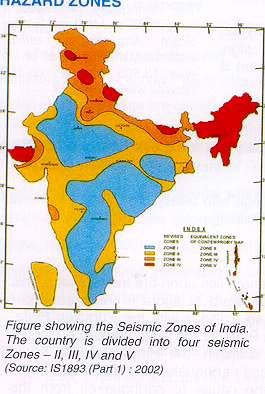
D. Earthquake
Though Sindhudurg district has no earlier history of earthquakes
still it comes under the seismic zone III. There was no loss in
Kankavli, Sawantwadi, Malvan and Vengurla due to the Killari
earthquake of 1993.
In Deogad taluka, a loss of 6 houses in the village Jambhavade
took place causing loss of Rs. 600/- and in Vaibhavwadi taluka Rs.
400/- of a house in the village Kolpe in earthquake of Killari and
Umarga in 1993. The proximity of the Western Ghat Fault Scarp and
evidences of neo tectonic activities in the Konkan area point to the
earth movements in the recent past and the possibility of an earthquake
cannot be ruled out. There is no history of earthquakes in this district
earlier.
3.2 Vulnerability Assessment
A. Flood and Cyclones
Based on the previous history, Sindhudurg district has an unexpected rainfall and flash flood
followed by landslides and road accidents. This district receives high amount of rainfall during the
rainy season. As a result most of the rivers get excess water and experience floods. This heavy
rainfall also results in landslides in isolated areas characterized by steep slopes.
The major rivers where flood comes at least once a year are:
1. Waghotan 2. Sukhnadi 3. Tillari 4. Karli 5. Gad Nadi
Apart from flood, tidal waves may affect the villages close to the Arabian Coast during
cyclone and Tsunami. Flood in 2005 affected almost the whole district by and large. The estimated
loss resulted by this flood was more than 9 crores.
Identified Flood Prone Villages
Taluka – Sawantwadi
Gram Panchayat Flood Prone No.of families Red Zone River / dam
village/wadi or Blue khadi
/persons to be
Zone
affected
Insuli Dhuriwadi 132 persons - Terekhol
Bilewadi 278 persons -
Kudavtemb - -
Banda Machhi Market 150 persons - Terekhol
Nimajagawadi - -
Tulsanpulwadi - -
Sherle Kapaiwadi 6 families - Terekhol
Dukanwadi 3 families -
Talawade Joshiwadi 41 persons - Hodawada
Pedanekarvadi 33 persons
Murarvadi 34 persons
Kaleredakarvadi 22 personsAlikadchi Khervadi 3 persons
Bhutachi Vadi 5 persons
Aaronda Aaronda 14 families - Terekhol
Kinle Kinle 10 families - Terekhol
Kavthani Kavthani - - Terekhol
Satarda Varchiwadi 5 - Terekhol
Rayache Ped - - Terekhol
Satose Satose - - Terekhol
Taluka – Malvan
Gram Panchayat Flood Prone Families/persons Red or blue River / dam
village/wadi to be affected Zone khadi
Masure-Marde Kava 428 persons - Gad-Kalawal
Khadi
Sayyad Juva 108 persons -
Masure- Marde-Usalatvadi 110 persons - Gad-Kalaval
Dangmode Khadi
Marde-Tokalvadi 165 persons -
Khajanvadi 110 persons -
Bandivade- Malawadi 174 persons - Gad-Kalaval
Budruk Khadi
Shilwadi 7 persons -
Khorwadi 2 persons -
Palavevadi 61 persons -
Malgao Malgao 50 families Gad Nadi
Bagayat Bagayat
Chinder Aparajwadi 35 families
Taluka – Kankavali
Gram Panchayat Flood Prone No. of families / Red Zone River / dam
village/wadi persons to be or Blue khadi
affected Zone
Phonda Phonda 12 families Gad River
Kalmath Kalmath 32 families
Varavade Varavade 31 families
Fanasnagar 15 families
Kharepatan Bandargao, Kajirde 30 families Suk River
Taluka – Vaibhavwadi
Gram Panchayat Flood Prone No. of Red Zone or River / dam
village/wadi families / Blue Zone khadi
persons to be
affectedNadhawade Sardarwadi 50 persons - Gothana
Yedgao Inamdarvadi 100 persons
Napane Napane 200 persons -
Shanti Nadi
Kokisare Ghangalevadi 50 persons
Umbarde Umbarde 300 persons
Sukhnadi
Kusur Kusur 100 persons
Sonali Sonali 200 persons 200
Taluka – Deogad
Gram Panchayat Flood Prone No. of families Red Zone or River / dam
village/wadi / persons to be Blue Zone khadi
affected
Dhalavali Muslimvadi 25 families Vijaydurg Khadi
Korle Belanekarvadi 10 families
Khanvilkarvadi
Bhatvadi
Malape Muslimvadi 20 families
Manache Muslimvadi 30 families
Taluka – Kudal
Gram Panchayat Flood Prone No. of Red Zone or River / dam
village/wadi families / Blue Zone khadi
persons to
be affected
Kudal Aambedkarnagar 81 Karli River
Population
Kavilkate 10 persons
Laxmiwadi(NEAR ST 31 persons
DEPOT)
Pawashi Shelatewadi 146 persons
Bao Bagwadi 31 persons
Sarambal Dewoolwadi 101 persons
Chendvan Malewadi 232 persons
Taluka – Vengurla
Gram Panchayat Flood Prone No. of Red Zone or Blue River / dam
village/wadi families / Zone khadi
persons to be
affected
Hodawada Kavdaswadi 74 persons - Hodawada TulasKasturbawadi 48 persons -
Nhaikarwadi 61 persons
Bhoj 16 persons
Dalviwadi
Harijanwadi 59 persons
Dewoolwadi 19 persons
Parabwadi 11 persons
Subhashwadi 33 persons
Kelus Ranjanwadi 14 persons Kalavi Nadi
Bapadatewadi 48 persons
Madhaliwadi 34 persons
Kalavi- 29 persons Kalavi Nadi
Kalavi Taliwadi
Bokarewadi 19 persons
Kalavi 295 persons
Chipi Chipi 22 persons Karli Khadi
Flood prone villages are not demarcated as Red zone or Blue zone but the work is in
progress.
Most of the areas in the district are flood prone and therefore there is a danger to human life,
livestock and property. The people living in kaccha mud houses are more vulnerable to flood. Here
most of the people are engaged in agriculture therefore standing crops may be destroyed. Old
people, pregnant women, disabled persons are highly vulnerable. They have to be shifted to safe
shelters.
It is estimated that the above 85 villages are vulnerable to floods and cyclones. The main
elements which are vulnerable are the people staying near riversides, poor people, children, old
people and ailing people. The houses and the belongings of such people will be damaged. As the
main occupation of the people here is agriculture, their crops will be washed away. That is they will
lose their livelihood. The main infrastructures, communication system will be disturbed. Sources of
drinking water will become impure. Necessary steps will have to be taken to restore the same.Tidal Wave Prone Villages / Wadis
Taluka Gram Panchayat Tidal Wave prone Village / Wadi
Vengurla Redi Velagar
Kerawade
Vengurla Kurlewadi
Navabag
Nivti Kelus – Kalwibandar
Bhogave to Newalewadi
Kille – Nivti to Dungoba Devasthan
Nivti – Medha
Malvan Malvan Talashi Tondavali to Waingani
Devbag – Mobarwadi
Tarkarli
Dandi Vayri
Dandi to Dhuriwada
Rajkot to Medha
Rajkot to Sarjekot
Achara Waingani to Tondavali (Middle Part)
Pirachiwadi to Jamdool
Morve to Tambaldeg
Deogad Deogad Taramumbari
Mith Mumbari
Anandwadi
Deogad Killa
Jamsande
Wadatar
Mallai
Vijaydurg Kharepatan
The villages near the three coastal talukas will suffer a lot during high tide, cyclone, storm, etc. The
fishermen living in these areas lose their livelihood. They do not get the
danger warnings in time. Most of the land near the seacoast gets eroded
and submerged into the sea every year.
B. Road Accidents
About 107 km of the National Highway Mumbai-Konkan-Goa passes
through this district and has considerable transport of hazardous
materials which are offloaded at Marmagoa harbour in Goa and
transported to Mumbai and places in Maharashtra. State HighwayNo.112, 115, 116 carry goods as well as people everyday on a large scale. Most of the accidents occur during rainy season due to slippery roads. Also the drivers do not follow the traffic signals. The roadside houses, buildings are more likely to get affected due to the road accidents. C. Landslides Due to heavy rain some parts of the district experiences landslides along with tree collapse leading to human loss. The passengers have to stay where they are. Amboli Ghat on Sawantwadi – Amboli -Belgaum Road State Highway No.112 supplies daily necessities such as milk, various goods which comes to a standstill. As a whole the communication system may totally get disrupted. There is a control room at the Collector Office,district head quarter which works round the clock. At each tahsil office control room is in operation during monsoon period i.e. from June to October. The control room of Police works round the clock. The officers of the control room of the district administration receives the information of flood, heavy rainfall, cyclone warning, uprooting of large number of trees, electric poles, road accidents, from various parts of the district and from IMD Colaba office and transmitting them to all Tahsil offices, Collector, RDC and Dy Collectors, Port and Fisheries Department. The Irrigation Department maintains control room on all the dam sites from June to October every year. D. Industrial and Chemical Accidents Sindhudurg is primarily an agricultural district with industrial areas accounting less than 1% of the total area of the district. There is M.I.D.C. Estate at Kudal and two Udyamnagars at Kudal and Majgaon in Sawantwadi Taluka. The core industries are plastic engineering, aluminium utensils, cashew processing, oil paints, cement pipe manufacturing, sleepers manufacturing and pig iron factory at Redi. Thus, Sindhudurg district is vulnerable to various hazards as mentioned above. The data of the disasters and the vulnerable population and the other elements have been discussed in this chapter.
4. INSTITUTIONAL MECHANISM
The disaster management will be more effective and sustainable if it is institutionalised. For this
purpose Government of India has already passed Disaster Management Act on 23rd December,
2005, where it is clearly outlined that a Disaster Management Authority to be formed at the
district level. It will be the apex body at the district level. Disaster management would involve
many layers of participating organization. The three focal levels would be State, District and the
site of the disaster. The State level agencies would be involved in policy/decisions making,
resource and budget allocation and monitoring through the State Emergency Operations Centre.

Similarly, at district level a District Disaster Management Authority is already formed and
activated to mitigate any unexpected situation in the district. There are seven members included
in this authority.

                District Disaster Management Authority

               District Disaster          Taluka Disaster             Village Disaster
                Management                 Management                  Management
                 Committee                  Committee                   Committee

                    District Disaster         Taluka Disaster            Village Disaster
                   Management Plan           Management Plan            Management Plan

                     District Search &         Taluka Search &           Village Search &
                      Rescue Team               Rescue Team               Rescue Team

                                                                         Village First Aid
                     District First Aid         Taluka First Aid               Team
                           Team                     Team

                                                                          Early Warining
                      Early Warining             Early Warining                Team
                           Team                       Team
The Institutional Framework for disaster management developed at the District, Taluka and Village level is as follows:- At each level, apart from disaster management committee, each level has a disaster management plan along with the various task forces like search and rescue, first aid, early warning, shelter management, etc. Sindhudurg district has its own district disaster management authority chaired by the district collector. Besides, the district disaster management committee is also working under district collector where all line departments are its member. The District search and rescue team consists of 36 members belonging to various departments is also set up in the district. At taluka level every taluka in the district has a taluka disaster management committee headed by tahsildar. As said above all line departments at taluka level are its members. Also a search and rescue team as well as first aid team have been set up at every taluka. At village level, every panchayat has a village disaster management plan as well as village disaster management committee. The VDMC chaired by sarpanch includes talathi, gramsevak, teacher, health workers, etc. of 10 – 12 persons. Also a search and rescue team as well as first aid team have been set up and trained at every village. 4.1 District Disaster Management Authority (DDMA) Sr. Designation Position No. 1 District Collector ( District Disaster Manager) Chairperson 2 Chairperson, Z.P. Vice Chairperson 3 Chief Executive officer, Z.P. Member 4 Superintendent of Police Member 5 Civil Surgeon Member 6 Executive Engineer (PWD) Member 7 Executive Engineer (irrigation) Member 8 Additional Collector / RDC Member Secy. The District Disaster Management Committee (DDMC) is an apex planning body and plays a major role in preparedness and mitigation.The district level response is co-ordinated under the guidance of the District Collector, who acts as a District Disaster Manager.
4.2    District Disaster Management Committee (DDMC)

Besides this, the Disaster Risk Management Programme also traced much to form Committees at
the three levels with plans and task forces. A Disaster Management Committee exists to assist
the Collector in
♦ Reviewing the threat of disasters
♦ Vulnerability of the district to such disasters
♦ Evaluating the preparedness
♦ Considering the suggestions for improvement of the response document DDMP

The Committee meets once a year under the chairmanship of the Collector and consists of the
following functionaries

The Collector                                                           Chairman
The District Superintendent of Police                                   Member
The Chief Executive Officer, Zilla Parishad                             Member
The Additional Collector                                                Member
The Resident District Collector                                         Member-Secy
The Chief Fire Officer                                                  Member
The District Health Officer                                             Member
The District Agriculture Officer                                        Member
The District Animal Husbandry Officer                                   Member
The Civil Surgeon                                                       Member
The Executive Engineer, P.W.D.                                          Member
The Executive Engineer, Irrigation Department                           Member
The Executive Engineer, Minor Irrigation Division                       Member
The Executive Engineer, M.S.E.D.C.                                      Member
The Executive Engineer, MWSSB                                           Member
The Deputy Director of Education                                        Member
The Divisional Manager, Railways                                        Member
The Regional Transport Officer                                          Member
The Regional Manager, M.S.R.T.C.                                        Member
The District Publicity Officer                                          Member
The District Supply Officer                                             Member
The Local Station Director, A.I.R.                                      Member
The Local Station Director, Doordarshan                                 Member
Coordination Structure at District level

                         District Collector (District Disaster Manager)

                     District Control room (Desk Officer & Officers in charge)

                                                                                  CEO
         Site operations centre

                             Feeding                                              Police
   Transit
                              camps
   camps
                                                                             Civil hospital
Relief camps                Cattle
                            camps
                                                                                 PWD

                                                                                 MWSSB

                                                                                 MSEDC

                                                                                  RTO

                                                                          District level line departments
   4.3       District Control Room

   The District Control Room, under the control of the district collector, will be the nerve center. It
   has been set up
   ♦         To monitor
   ♦         Co-ordinate
   ♦         Implement the actions for disaster management

   It works throughout the year and orders the various departments to work as per the directions
   during the disaster.
4.4 Communication Mechanism
On the basis of reports from the possible disaster site, or on the warning from the agencies
competent to issue such a warning, or on the receipt of warning or alert from Emergency
Operations Center, the Collector will exercise the powers and responsibilities of the District
Disaster Manager.
The list of the agencies competent for issuing warning or alert is given below :
Disaster Agencies
Earthquakes IMD, MERI
Floods Meteorology Department, Irrigation
Department
Cyclones IMD
Epidemics Public Health Department
Road accidents Police
Industrial and Chemical Accidents Industry, Police
Fires Fire Brigade, Police
The warning or occurrence of disaster will be communicated to
♦ Chief Secretary, Relief Commissioner, Emergency Operation Center
♦ Office of Divisional Commissioner
♦ All district level officials, Municipal Councils
♦ The Officials of central government located within the district
♦ Non-officials viz; Guardian Minister of the district, Mayor, ZP President,
MPs, Local units of the Defense Services.
The occurrence of the disaster would essentially bring into force the following :
♦ The District Collector will activate the District Control Room as the District Disaster
Manager.
♦ The DCR will be expanded to include desk arrangements with the responsibilities for
specific tasks.
♦ All district level staff from various departments will be under the direction
and control of the District Disaster Manager. These would also include the district level
staff of Zilla Parishad
Municipal Authorities
MSEDC
MWSSB
PWD
MSRTCYou can also read