Reduction of vulnerability to coastal flooding through ecosystem based adaptation in the south of Artemisa and Mayabeque provinces - UNDP
←
→
Page content transcription
If your browser does not render page correctly, please read the page content below

Reduction of vulnerability to coastal flooding
 through ecosystem‐based adaptation
in the south of Artemisa and Mayabeque provinces
DATE OF RECEIPT:
 ADAPTATION FUND PROJECT ID:
 (For Adaptation Fund Board
 Secretariat Use Only)

 PROJECT/PROGRAMME PROPOSAL
PART I: PROJECT/PROGRAMME INFORMATION

PROJECT/PROGRAMME CATEGORY: REGULAR PROJECT (CONCEPT)
COUNTRY/IES: CUBA
TITLE OF PROJECT/PROGRAMME: Reduction of vulnerability to coastal flooding
 through ecosystem-based adaptation in the south
 of Artemisa and Mayabeque provinces
TYPE OF IMPLEMENTING ENTITY: MIE
IMPLEMENTING ENTITY: United Nations Development Programme
EXECUTING ENTITY/IES: CITMA-MINAGRI
AMOUNT OF FINANCING REQUESTED: US$6,067,320 (in U.S Dollars Equivalent)

PROJECT / PROGRAMME BACKGROUND AND CONTEXT:
Summary Overview
The proposed project seeks to reduce the vulnerability of communities in coastal areas of
Artemisa and Mayabeque provinces in southern Cuba from climate change (CC) related
phenomena including coastal erosion, flooding and saltwater intrusion. Under different IPCC
scenarios and levels of climate sensitivity, sea levels in Cuba are expected to rise by between
0.22m and 0.85m by the year 2100, with an annual acceleration in SLR rates of 0.01mm. Cuba
lies in one of the most active parts of the Atlantic/Caribbean hurricane region: hurricanes and cold
fronts are among the principal causes of destructive flooding along the whole length of the Cuban
coastline, giving rise to strong winds and high energy waves which can lead to significant levels
of flooding. Given its long and narrow configuration, Cuba has a particularly high ratio of coastline
to overall surface area and, as a consequence, a large proportion of the national population is
vulnerable to such CC-related threats.

Mangroves cover a total area of 5647 km2 nationwide, equivalent to 5.1% of the total area of the
country. They have suffered high levels of degradation and elimination in many areas. Human
impacts on mangroves include their direct elimination and the modification of the hydrological
regimes on which they depend (elimination or reduction of water flows, and the reduction of
freshwater and nutrient inputs and consequent increases in salinity which can prove lethal). They
play a vital protective role against the effects of sea level rise and storm surges, by protecting
coastal ecosystems, settlements and agricultural land further inland against wave impacts, and
stabilizing coastlines which are otherwise receding at rates of up to several metres per year.

The project will focus specifically on an 84km long stretch of coastline, covering 27,500ha, in the
western provinces of Artemisa and Mayabeque. This coastline is comprised of a large coastal
wetland area based on clay and terrestrial deposits, dominated by mangroves (with a total area
of 634km2), into which numerous rivers, estuaries and coastal lagoons drain. This is one of the
most vulnerable in the country to tropical storms and hurricanes, and associated storm surges. It

 1
is particularly to subject to the problem of saline intrusion into its subterranean aquifers, which are
vital for the irrigation of the coastal plains, which are some of the most productive agricultural in
the country, and as a source of drinking water for the city of Havana. The narrowness of this area
(which in places is little more than 30km in width) means that is susceptible in almost its entirety
to CC-related impacts. Some of the highest levels of beach erosion in the country have occurred
in this area, and the mangroves of the area also have some of the lowest health indices in the
western region of the country.

Mangroves in this area have been heavily impacted in the past by the extraction of timber and
poles, and by infrastructural works such as the construction of drainage channels, a 50km long
retention wall and a coastal road. There is clear evidence that those parts of the coast with intact
mangrove forests have been less affected by CC-related phenomena than those that have
undergone significant anthropogenic modification, due largely to the role of mangroves in
retaining sediment and buffering wave impact. Furthermore, benthic environments in coastal
waters are generally less degraded in the areas where the seaward belt of red mangrove is intact.
The project is designed to enhance the ability of ecosystems to supply this buffering function. The
project will focus in particular on restoring and rehabilitating the areas, covering a total of 7,318ha,
which have suffered severest degradation and which constitute flooding hotspots. This will serve
to enhance the functionality of the landscape as a whole, stretching along 134km of coastline and
covering a total of 27,500ha.

Cuba has a well-developed institutional framework, well-organized communities at local level, and
excellent technical capacities for research into coastal ecology and the development of
corresponding strategies for the management of coastal ecosystems. However the following
barriers impede the effective implementation of EBA:

1. EBA is not factored into adaptation measures: responses to CC impacts have until now
focused principally on structural and behavioural adaptation rather than EBA, due in large part to
limited access, among institutions operating at field level to knowledge and to technical and
logistical resources.

2. CC is not factored into coastal zone development: the planning and management of
productive activities in the coastal zone has been governed by narrow and sector-specific visions
which have failed to consider the longer term benefits and cost-effectiveness of avoiding damage
to ecosystems which have potential to provide EBA services. This is compounded by the limited
levels of awareness that exist in local communities regarding climate change and EBA.

3. Cost benefit calculus for EBA: there is limited appreciation by decision-makers at different
levels of the precise nature and magnitude of the costs and benefits of EBA, compared to the
alternatives, and of human activities that contribute to the degradation of these ecosystem
services and reduce climate change resilience.

The project’s objective will be achieved through investments in three complementary components.
Component 1 will focus on concrete investments in ecosystem recovery, leading to improved
coastline resilience to the impacts of wave action, and improvements to coastal morphology which
will reduce seawater incursion; this will be achieved by re-establishing the coastal belt of red
mangrove between Surgidero de Batabanó and Punta Mora, restoring mangrove ecosystems
between Majana and Surgidero de Batabanó, eliminating and/or controlling invasive alien species
and restorating and enriching woodlands along the landward limit of the coastal wetland belt.
Component 2 will focus on integrated and participatory management of coastal ecosystems,
through mainstreaming EBA into integrated coastal zone planning and productive sector activities,

 2
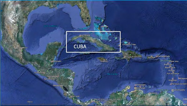
promoting buy-in, participation and governance in local communities and developing knowledge
management systems at community level. Component 3 will focus on establishing a favourable
enabling environment at regional level for the effectiveness and sustainability of adaptation
investments, through the provision of consolidated information on costs and benefits of EBA to
decision makers and planners and the strengthening of institutions supporting EBA actions, within
the framework of updated and actively implemented action plans

Geographic & Environmental Context
The Republic of Cuba is located in the Caribbean Sea, at the entry of the Gulf of Mexico at a
distance of 140km from the Bahamas, 180km from Florida, 210km from Cancún, 77km from Haití
and 146km from Jamaica (Figure 1). Its total surface area is 109,886.19km², made up of the
Island of Cuba (107,466.92km²), the Island of Youth (2,419.27km²) and almost 1,600 other
islands, islets and cays totalling 3,126.43km².

Figure 1. Location of the Republic of Cuba

The country is divided into 15 provinces (Figure 2) and 168 municipalities (including the special
municipality of the Island of Youth), of which 96 have coastline.

 3
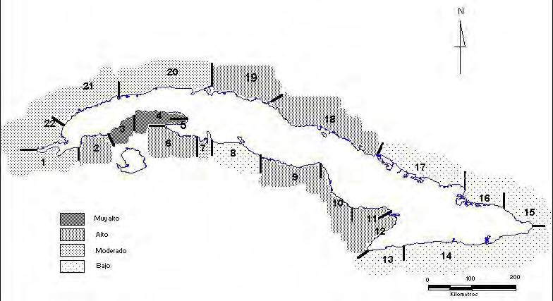
Figure 2. Political/administrative divisions (ONE, 2010)

 Target area

The total population of the country is 11.2 million: these are distributed between 7075 settlements
including the capital, Havana, which is home to 2 million people. 92% of the settlements are rural
and 8% urban; there are 262 coastal settlements, without including the city of Havana. The
country’s Human Development Index score stands at 0.776 (High), ranking 51 worldwide out of
187 countries.

The coastal zone comprises virtually the whole of the archipelago: the total length of the coast is
5,746km (3,209km on the north coast and 2,357km on the south coast). The coastline is very
irregular and diverse, including steep cliffs, sandy beaches, extensive low lying and swampy
coastal plains, fringing coral reefs, marine terraces, inlets, deltas and bays.

Most coastal communities are characterized by a narrow economic base, dependent largely on
artisan fishing, basic services and domestic tourism; in addition, many members of coastal
communities are involved in agriculture and livestock raising in neighbouring areas due to limited
employment opportunities in their own areas. Coastal communities have also been affected by
decreasing employment opportunities due to the decline of the fisheries sector and the
degradation of productive infrastructure by the weather and extreme climatic events.

Existing Climate & Climate Change Scenarios
Cuba is moving towards climatic conditions similar to those projected by the IPCC under a
scenario of intensified greenhouse gas effect, particularly in relation to increases in surface level
air temperatures, reductions in daily temperature ranges, increased frequency of long and severe
droughts, especially in the dry season, and increases in the total amounts of rainfall associated
with major precipitation events in the wet season.

Ample evidence has been generated by Cuban institutions and others regarding climate change
and variability to date, and the corresponding vulnerability of human populations. Studies of
circulation patterns in the Caribbean suggest that the structure and influence of the
Azores/Bermuda High Pressure System on the region have undergone changes at a multi-decade
scale (Naranjo y Centella, 1997). A significant warming of the lower troposphere of the region was
detected in the 1970s, which is consistent with overall climate change and is in accordance with

 4
the significant patterns detected in circulation patterns in the Pacific/North American sector
(Trenberth and Shea, 1997).
The El Niño-Southern Oscillation (ENSO) has a strong influence on climatic vulnerability in Cuba.
This is reflected in increases in precipitation and the frequency of extreme weather events during
the rainy season (Cárdenas y Naranjo 1996; Alfonso 1995). Although the influence of the ENSO
has not been consistent over time, Naranjo and Centella (1997) suggest that its impact in the
Caribbean has increased since the 1970s, and that this is related to underlying changes in climatic
conditions since that time.

There has been an increase in anticyclonic influence in Cuba, which has resulted in a predominant
effect of ocean currents from the east and descending vertical movements. This coincides with
the tendency observed in the pattern of teleconnection of the Eastern Atlantic, one of the most
important modes of variation of atmospheric circulation in the Atlantic Ocean. This pattern has
maintained a statistically significant tendency of linear increase over the period 1951-2008. This
tendency is a consequence of the marked multi-decade variation that has been shown, with a
prevailing negative phase between 1951 and 1976 and a positive phase from 1977 to the present.
During this latter phase, the 1996-2010 period stands out, in which the positive trend has been
very strong and persistent, coinciding with a greater increase in sea surface temperature in the
tropical Atlantic ocean,

It is probable that a close link exists between the patterns in anticylonic activity, observed
variations in teleconnection patterns of the Pacific-North America región, North Atlantic Oscillation
(NAO) and Eastern Atlantic (EA), with the observed fluctuations of temperature and precipitation.
Increases in the frequency and intensity of droughts appear to be linked to these processes.
The most recent evaluation of climatic variation and change in Cuba, carried out by the
Meteorological Institute of CITMA (R. Pérez et al. 2009), provides observation-based evidence
which clearly indicates that the climate in Cuba has become warmer. Since the middle of the last
century, the median annual temperature has increased by almost.9°C. The last two decades
stand out as the hottest registered to date. Associated with this trend, there has been a very
marked increase in mínimum temperatures, the monthly average values of which have increased
by around 1.9°C. There have been no corresponding statistically significant trends in maximum
temperatures, meaning that median daily temperature fluctuations have reduced by almost 2°C.

 5
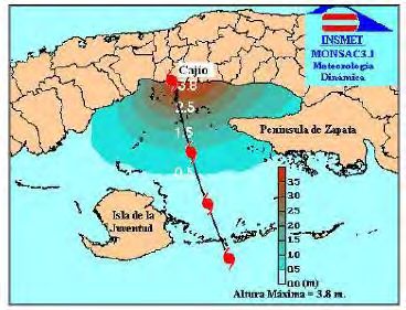
Figure 3. Trends in annual median values of minimum temperature in Cuba, 1951-2008
 (Pérez et al, 20091)

The same evaluation found no statistically significant trends in rainfall totals in the country. The
most important phenomenon has been the reduction in wet season (May-October) rainfall in the
east of the country: in the 1990s, this region showed significant deficits in cumulative rainfall
levels. Another interesting aspect with regard to precipitation levels is an increase in dry season
(November-April) rainfall, related to a reduction in the magnitude of negative anomalies from the
1970s to the 2000s.

The significant increase in drought events that has been registered in the periods 1961-1990 and
1931-1960 continued into the 1990s, as shown by the persistent drought events that affected the
east of the country since the beginning of that decade, culminating in the severe event that
stretched from May 2003 to 2005, which progressively extended to affect the whole of the country.
This behaviour is linked to the strengthening of anticylonic influences over Cuba at medium and
high levels, which in turn is linked to a strong increase in descending vertical movements in the
atmosphere.

Climatic trends related to coastal flooding
In recent decades, the increase in global temperatures has been reflected by increases in the
temperature and salinity of both superficial and sub-superficial waters around Cuba (Mitrani y
Díaz, 20082), which corresponds to those observed by Curry et al. (2003). This situation results
in increases in the thermic energy of the ocean which is available for the development of
atmospheric systems. As argued by Anthes et al. (2006), increases in temperatura and salinity
lead to changes in atmospheric and oceanic circulation, which favor the intensification of the
transport of moisture from the sub-tropics to higher latitudes; this affectes the Multi-Decadal

1
 Pérez Suárez, R., C. Fonseca, B. Lapinel, C. González, E. Planos, V. Cutié, M. Ballester, M. Limia and R. Vega
(2009): “Segunda evaluación de las variaciones y tendencias del clima en Cuba”. Informe científico. Instituto de
Meteorología. La Habana, 75 pp.”
2 Mitrani and Díaz O. (2008): “Particularidades de la estructura termohalina y sus tendencias en aguas Cubanas”

Revista Cubana de Meteorología, Vol. 14, No. 1 54:73

 6
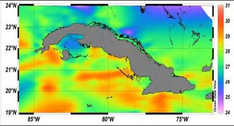
Oscillation of the Atlantic, which is one of the mechanisms with most influence on the frequency
and intensity of tropical cyclones. The parameters which best reflect this situation are Ocean
Surface Temperature and Maximum Salinity, in deep water (between 150 and 300m below the
surface).

Figure 4 shows monthly variation patterns in these parameters over the 1966-2000 period, as
well as averages for the two periods 1966-1980 and 1981-2000. Average values for the latter
period are greater or equal than the median.

Figure 4. Monthly variations in Ocean Surface Temperature (a) and Maximum Salinity (b)
 in the 1966-1980 and 1981-2000 periods

As a consequence of these changes, the capacity of the sea to accumulate heat has increased,
as has the depth of the homogenous layer with temperatures greater than 26 oC (Mitrani et al.
20083), leading to increases in the formation and destructive power of tropical cyclones.

Figure 5 shows that maximum values of Ocean Surface Temperature and Maximum Salinity are
located close to both coasts of the western region of Cuba (Mitrani et al. 2008), which makes
these areas the most vulnerable to increases in coastal flooding.

Figure 5. Spatial Distribution of (a) Ocean Surface Temperature and (b) Maximum Salinity
 values in relation to Cuba (averages for 1966-2000)

3
 Mitrani-Arenal et al. (2012): Tendencias climáticas de las inundaciones costeras severas en áreas de Cuba.

 7
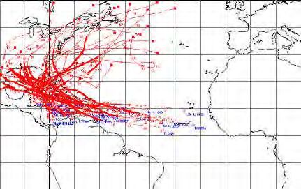
Sea Level Rise (SLR):

Under different IPCC scenarios and levels of climate sensitivity, sea levels in Cuba are expected
to rise by between 0.22m and 0.85m by the year 2100 (Table 1). The linear annual trends of sea
level rise that have been detected in the Cuban archipelago have varied between 0.214cm/year in Sibonet
and 0.005cm/year in Casilda. These differences are a function of the oceanographic, hydrographic and
topographic conditions in the areas adjacent to the measurement stations (Hernández et al. 20114). There
is predicted to be an annual acceleration in this SLR trend of around 0.01mm.

Table 1. Predictions of sea level rise in Cuba up to the year 2010, relative to the last
 decade of the 20th century (mm)
 IPCC Climate sensitivity 2020 2050 2070 2100
 scenarios
 A1C Low (1.5oC) 4 8 14 22
 Medium (2.6 C)
 o 9 17 30 49
 High (4.2oC) 15 27 48 85
 B2 Low (1.5oC) 4 7 10 15
 Medium (2.6oC) 10 16 23 35
 High (4.2 C)
 o 15 26 40 62

Weather systems
The Atlantic Ocean is the source of approximately 11% of the tropical depressions, storms and
hurricanes in the world. Figure 6 shows that Cuba lies in one of the most active parts of the
Atlantic/Caribbean hurricane region. Hurricanes and cold fronts are among the principal causes
of destructive flooding along the whole length of the Cuban coastline (Mitrani et al. 2001). These
phenomena give rise to strong winds and high energy waves which result in accumulations of
water which can lead to significant levels of flooding.

Over the last 8 years a total of 13 cyclones have affected the country, causing damage to
1,234,784 homes of which 12.4% collapsed completely. From 2001 to the present, the country
has been affected by seven intense hurricanes, the highest rate in a single decade since 1791.

Historically, intense hurricanes have represented 26% of the total number of hurricanes affecting
the country. During the first decade of the 21st century, however, this proportion rose to 78%. This
corresponds to the increase observed across the Atlantic as a whole5, including the Caribbean,
and may be related to the high temperatures observed in the Caribbean since 1998.

4
 Hernández, M et al (2011): Informe parcial correspondiente al 2010 del proyecto “Completar la determinación de la
tendencia del ascenso del nivel medio del mar y los valores extremos, desde 1966 hasta la fecha a partir de mediciones
directas”
Hernández, M., O. Marzo y A. Acanda (2010): Tendencia lineal del nivel medio del mar en algunas localidades del
archipiélago cubano. Serie Oceanológica. No. 7, p. 1 – 15. ISSN: 2072-800X. http://oceanologia.redciencia.cu.
Hernández, M., O. Marzo, Y. Ríos, L. Martínez and A. Boffil (2009a): Completar la determinación de la tendencia del
ascenso del nivel medio del mar y los valores extremos, desde 1966 hasta la fecha a partir de mediciones directas.
Informe Científico Anual. Archivo Científico del Instituto de Oceanología.
5 The trend over the past 200 years has not been statistically significant.

 8

Figure 6. Category 4 and 5 Hurricanes affecting Cuba between 1890 and 1995

As a result of climate change, the storm surges arising from hurricanes and other storm events
will build upon higher baseline sea levels, to produce a cumulative effect, as shown in Table 2.

Table 2. Estimated area that would be flooded if a Category 5 hurricane were added to
 climate-change related sea level rise (km2)

 Year
 2050 2100
 Normal conditions (with climate change) 2,349.5 5,696.5
 Climate change + Category 5 hurricane 19,935.3 20,614.2

Coastal ecosystems
Mangroves cover a total área of 5647 km2 nationwide, equivalent to 5.1% of the total area of the
country. They have suffered high levels of degradation and elimination in many areas. Human
impacts on mangroves include their direct elimination and the modification of the hydrological
regimes on which they depend (elimination or reduction of water flows, and the reduction of
freshwater and nutrient inputs and consequent increases in salinity which can prove lethal). They
play a vital protective role against the effects of sea level rise and storm surges, by protecting
coastal ecosystems, settlements and agricultural land further inland against wave impacts, and
stabilizing coastlines which are otherwise receding at rates of up to several metres per year.
Beaches account for 16% of the coastline of Cuba, and studies carried out over the last 30 years
have shown that 90% of beaches have been affected by erosion (Juanes et al, 1996), in large
part due to the elimination of the protection offered by mangroves but also due to the impacts of
coastal infrastructural works.

Coral reefs have been seriously affected by bleaching in recent years, which is directly attributable
to CC-related increases in water temperature and is compounded by anthropogenic damage and
the increased impacts of hurricanes. This decline has serious ecological and socioeconomic
implications, given the importance of coral reefs as refuge and food source for fish and
invertebrates, and in protecting coastline against wave impacts. Around 70% of reef crests in

 9
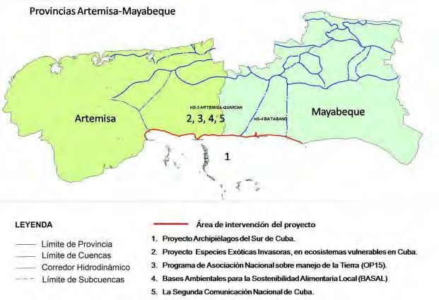
Cuba are highly deteriorated, due to a combination of factors including the excessive growth of
algae resulting from declines in the populations of aquatic herbivores, health problems including
bleaching and, in certain sites, pollution. It is not however thought that SLR will have direct impacts
on crest corals in the country (by increasing the depth of water above them and therefore reducing
photosynthesis) as its rate is not expected to exceed the growth rate of the corals.

Current prediction models estimate a structural disappearance of coral crests around Cuba within
around 40 years (Alcolado et al., 2009). This disappearance does not necessarily imply wholesale
coral death, but rather a reduction of their physical profile: the reefs are composed of species
such as Millepora complanata, Siderastrea siderea and Porites astreoides, which are generally
resistent to a number of factors, but they will not have a sufficient height to be able to contribute
effectively to the dissipation of wave energy and the protection of the coast.

An estimated 2.6 million ha of other ecosystems would be affected by the SLR that is expected
by 2100, including 1.98 million ha of permanent wetlands, 507,500ha of forests, and 11,900ha of
scrub.

Socioeconomic implications of climate change, SLR and storm surges
Given the insular nature of the country, a large proportion of Cuba is subject to the effects of SLR
and storm surges. Of the total of 15 provinces (plus the special municipality of the Island of Youth),
a total of 96 municipalities located near or close to the coast are subject to permanent effects
from these phenomena. Of the country’s 7075 human settlements, 262 are coastal and of these
122 (53 urban and 69 rural) will be affected and 21 are predicted to disappear by the year 2100.
The damage to coastal settlements and agricultural land by these CC-related phenomena has
particularly severe impacts on women, who typically are the first to be obliged to relocate in order
to ensure adequate living conditions for their children.

By the year 2100, it is estimated that a total of 112,491ha of agricultural land will have been
permanently or temporarily affected by sea level rise; if combined with a Category V hurricane,
this total would rise to an estimated 1,658,665ha, or 25.5% of the agricultural land in the country.
The crops most likely to be affected would be pasture, sugar cane and rice. The most extreme
climate change/SLR scenario presented in Table 1 (0.85m) would result in the flooding of up to
5,696km², affecting more than 1 million people living in more than 220 settlements.

A sustained rate of SLR of 2.9mm/year would result in a total rise of around 0.3m over the next
100 years and a consequent retreat of the coastline of between 800 and 1,500km (without taking
into account storm surges). This would have major impacts in terms of saline intrusion into
subterranean aquifers, which in many areas are of fundamental importance for agricultural
irrigation and domestic water supply.

The target area
The project will focus specifically on an 84 km long stretch of coastline between Punta Sucia and
Punta Mora in the western provinces of Artemisa and Mayabeque6, covering 6 municipalities7,
(see Figure 7). This coastline, which lies on the Gulf of Batabanó, is comprised of a large coastal
wetland area based on clay and terrestrial deposits, dominated by mangroves (with a total area
of 634km2), into which numerous rivers, estuaries and coastal lagoons drain (Figure 8).

6
 These provinces were established in 2011 when the former province of Havana was divided into three parts: urban
Havana, Artemisa and Mayabeque.
7
 Artemisa, Alquízar and Güira de Melena in Artemisa province and, Batabanó, Melena del Sur and Güines in
Mayabeque Province

 10
Figure 7. Political divisions in the project area

Figure 8. Ecosystems in the project area
 KEY

 Mangrove forest Lagoons

 Swamp forest Dike
 Swamp grassland Roads

 Forest plantations Towns

This area is of crucial strategic importance: the plains that stretch from coast to coast include
some of the most productive agricultural land in the country, and its underlying aquifers are the
main source of water for the capital, Havana. The Southern Basin Aqueduct benefits a population
of around 137,000 people. At the same time, it is one of the most vulnerable areas in the country
to the diverse effects of climate change, due in part to its narrowness (in places less than 33km
from coast to coast).

The six target municipalities produce an average of around 2,385 tons of vegetables per year
(ONE, 2008). Batabanó municipality is home to the Pesca Habana Combined Fishery Enterprise,

 11
one of the most important in the country, which produces more than 900 tons of lobster, 300 tons
of scale fish and 30 tons of sponges per year.

Climate change effects in the target area

In the target area, the coastline is retreating at around 1.2m/year. It is predicted that the storm
surge associated with a a Category V hurricane would directly affect 49 settlements in this area,
with a combined population of 24,509 people: when SLR (which is estimated at 2.14mm/year) is
also taken into account, an estimated 36,253ha would be flooded by 2050 and 5 settlements
would completely disappear.

Table 3. Storm events and their impacts in the target provinces between 2000 and 2008

 Date Event Impacts
 Sept. 2000 Gordon Coastal flooding in the south of the former province of Havana,
 leading to evacuation of population from the south of Artemisa
 and Mayabeque provinces
 Nov. 2001 Michelle Sea incursion, population evacuation
 Sept. 2002 Isidore Coastal flooding, population evacuation
 Oct. 2002 Lili Coastal flooding
 Aug. 2004 Charley Strong sea incursion which destroyed settlements and beaches
 Sept. 2004 Ivan Coastal flooding, population evacuation
 July 2005 Dennis Coastal flooding, population evacuation
 Aug. 2005 Katrina Coastal flooding, population evacuation
 Sept. 2005 Rita Coastal flooding, population evacuation
 Oct. 2005 Wilma Strong sea incursion reaching more than 1km inland
 Aug. 2008 Gustav Dangerous coastal flooding reaching more than 1km inland,
 evacuation of population
 Sept. 2008 Ike Dangerous coastal flooding reaching more than 550m inland,
 evacuation of population

Table 4 and Figure 9 show that it is one of the most vulnerable in the country to tropical storms
and hurricanes, and associated storm surges. A storm surge of up to 3.8m was recorded during
Hurricane Charley in August 2004 (Figure 10). The areas in these provinces that are affected by
flooding during hurricane events of different intensities are shown in Figure 11.

Table 4. Periods of return of hurricanes and tropical storms in different regions of Cuba
 Region Tropical storms Hurricanes
 West 2.4 2.6
 Centre 5.6 6.3
 East 4.5 4.8

 12
Figure 9. Storm surge risk by sector

Figure 10. Storm surge caused by Hurricane Charley in August 2004

 Target
 area

 13
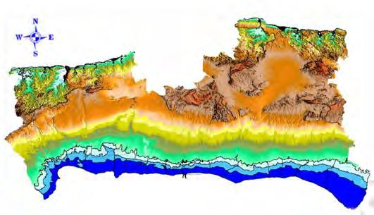
Figure 11. Areas of target provinces estimated to be affected by storm surge and waves
 during hurricanes

 Target
 area
 Category 5

 Category 3

 Category 1

Figure 12. Areas to be affected by CC-related saline intrusion, temporary flooding during
 hurricanes and SLR

 Limit of temporary flooding
 Limit of saline intrusion
 predicted during Category
 (salinity of 1g/L in
 V hurricane
 subterranean waters)

 Coastal communities
 affected by SLR

 Limit of area to be flooded by
 85cm SLR predicted by year 2100

Furthermore, this area is particularly to subject to the problem of saline intrusion into its
subterranean aquifers, which are typically located between 20 and 30m below sea level. The
agriculture of this area (which is one of the most productive in the country) is heavily dependent
on this aquifer for irrigation, as its highly permeable karstic geology means that there is little or no
surface water available. The area is also one of the main sources of drinking water for the city of
Havana. The narrowness of this area (which in places is little more than 30km in width) means
that is susceptible in almost its entirety to this problem.

The inherent vulnerability of the target provinces to climate-related effects is reflected in, and
exacerbated by, the high levels of degradation that have been suffered by their coastal
ecosystems. Some of the highest levels of beach erosion in the country have occurred in this
area: the beaches of Majana, Guanimar, Cajio, Mayabeque, Caimito, La Pepilla, Tasajera and
Rosario were left completely without sand as a result of the erosive waves generated by
Hurricanes Ike and Gustav in 2008. At La Pepilla beach, the coast is receding at a rate of up to

 14
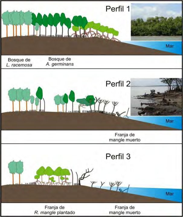
2m/year (Guerra et al 2000). The mangroves of the area also have some of the lowest health
indices in the western region of the country (Figure 13).

Threats to coastal ecosystems in the project area
Historically, the mangroves of this area have been heavily impacted by the extraction of timber
and poles for railway construction and for charcoal production. In the 1950s, a series of drainage
channels were built which had the effect of drying out the mangroves and coastal swamps, and
the forest on the landward margin of the swamps has suffered clearance by farmers, which has
had negative effects on the underlying aquifer. In order to counteract these processes a 50km
long retention wall (Dique Sur or Southern Dike) was built in the 1980s: this however resulted in
mortality of mangroves (principally black mangrove A. germinans) due to flooding on its landward
side, and increased wave impact and reduced freshwater inputs on its seaward side. These
effects have been exacerbated by the culverts in the wall being clogged by vegetation, and
compounded by increases in illegal harvesting of mangroves due to the access which the wall
provides into the otherwise impenetrable swamps and forests.

Additional impacts which have affected the different coastal ecosystems of this area since colonial
times include coastal development, construction of breakwaters, overfishing and sand extraction.

Figure 13. Health indices for mangroves in the western region of the country

There is clear evidence that those parts of the coast with intact mangrove forests have been less
affected by CC-related phenomena than those that have gone significant anthropogenic
modification, due largely to the role of mangroves in retaining sediment and buffering wave
impact. Furthermore, benthic environments in coastal waters are generally less degraded in the
areas where the seaward belt of red mangrove is intact.

The ecological integrity of coastal and marine ecosystems is particularly at risk from Invasive Alien
Species (IAS), the spread of which is facilitated by the scarcity of competitors and predators due
to the country’s geographical isolation. IAS have the potential to generate drastic impacts for
native ecosystems and to displace native species, directly or indirectly. Climate change will
potentially exacerbate the risks posed by IAS, resulting in exotic species which are not currently
invasive becoming so as climatic conditions favour their spread. Ecosystem disturbance as a
result of CC-related extreme weather events and fires also risks providing opportunities for exotic

 15
species with pioneer characteristics gaining a foothold in otherwise intact ecosystems and
preventing them returning through natural regeneration to their original state.

Scientific studies carried out in Cuba have shown that Casuarina equisetifolia, Dichrostachys
cinerea (Marabú), Leucaena leucocephala and Eichhornia crassipes (Water Hyacinth) have wide
presence in the project area and have important impacts on the regenerative capacities and
ecological balance of the target ecosystems. Casuarina equisetifolia in particular has well proven
negative impacts on the ability of coastal ecosystems to buffer the effects of climate change. On
sandy coasts, it has led to the significant modifications of coastline morphology, and the loss of
sand and natural vegetation due to its rapid growth and allelopathic effects.

There are also strong indications that Dichrostachys cinerea (Marabú), Leucaena leucocephala
and the Water Hyacinth have the potential to undermine EBA, although these remain to be
conclusively demonstrated. The negative impacts of these species in this regard including the
drying out of the wetlands due to high water demands relative to native vegetation; competition
with native species with greater ability to stabilize coastlines; and/or interference with the ecology
of the native wetland ecosystems, thereby reducing the ability of these to generate other
ecosystem benefits (such as fish nurseries or honey production) which might otherwise provide
additional incentives to the local population to participate in their conservation. Dichrostachys
cinerea (Marabú) has spread rapidly in recent years, becoming the invasive of greatest concern
in the country: it transforms natural ecosystems, converting them into spiny and impenetrable
thickets of little use for human activity. Leucaena leucocephala also invades abandoned cropping
areas and open areas of secondary vegetation, where it forms dense thickets which are of little
value for local communities and where it is difficult to establish native vegetation.

Barriers to Addressing the Climate Change-Induced Problems
Cuba has a well-developed institutional framework, well-organized communities at local level, and
excellent technical capacities for research into coastal ecology and the development of
corresponding strategies for the management of coastal ecosystems. The principal deficiencies
with regards to these aspects, which constitute obstacles to the effective implementation of EBA,
are:

1. EBA is not factored into adaptation measures
To date, responses by the Government and local actors in Cuba to the current and potential
implications of climate change in coastal areas have focused principally on structural and
behavioural measures. Foremost among the structural investments has been the construction of
the 50km long Southern Dike retention wall which, as explained in the previous section, has been
counterproductive in the long term, as it has interrupted natural hydrological processes and
thereby led to the mortality of mangroves, undermining the potential for EBA. Behavioural
measures have largely focused on short-term emergency responses and on relocating further
inland people living in communities which have suffered productive and infrastructural damage
from CC-related flooding and storms.

The limited attention that has been paid to EBA in practice is due in part to the fact that technical
knowledge and experiences of mangrove ecology and silviculture has been concentrated to date
in national research institutions (such as universities, the IINAF and the IES): the State-owned
forestry enterprises, which are responsible in practice for forest management in the area, have
strong technical capacities in relation to terrestrial silviculture (principally forest plantations) but
have not to date worked to any extent in coastal ecosystems. . The principal obstacle to the
effective application of EBA is limited access, among institutions operating at field level, to

 16
technical and logistical resources, especially the kinds of physical equipment that are required to
gain access to and operate effectively in the marshy and inaccessible sites where reforestation,
restoration and rehabilitation activities are to be carried out.

2. CC is not factored into coastal zone development
Some of the most significant negative impacts to which the coastal ecosystems of the project area
have been subjected to date, such as the obstruction of hydrological flows by the Southern Dyke,
the destruction of mangroves for the construction of the coastal road and the drying out of
wetlands for agricultural drainage, can be explained by a failure to apply a fully integrated vision
to the planning of productive activities in the coastal zone, or to develop adequate levels of
awareness of the importance of coastal ecosystems among local stakeholders engaged in
productive activities (members of local communities and productive sector entities). Each of these
activities was planned and executed with a narrow and sector-specific vision which failed to
consider the longer term benefits and cost-effectiveness of avoiding damage to ecosystems which
have potential to provide EBA services. Despite the existence of strong policy commitment to
EBA at various levels, this has not as yet been reflected in practice in the plans and investments
of individual sector institutions.

This situation is compounded by the limited levels of awareness that exist in local communities
regarding climate change and EBA. There is limited understanding among members of local
communities of how individual short-term climatic phenomena fit into the long-term pattern of
climate change, and the long-term cumulative implications of CC trends. Furthermore, local
stakeholders tend to under appreciate the value of coastal ecosystems such as mangroves and
wetlands for economic purposes and for climate change resilience: this undermines governance
and means that the underlying drivers of coastal ecosystem degradation are ineffectively
addressed.

3. Cost benefit calculus for EBA
Although there is solid policy commitment to addressing the implications of climate change (as
shown for example in the National Environment Strategy 2011-2015, the Cuban Civil Society
Progamme for Addressing Climate Change, and the First and Second National Communications
to the UN Framework Convention on Climate Change – see Section D), there is limited
appreciation by decision-makers at different levels of the precise nature and magnitude of the
costs and benefits of EBA, compared to the alternatives, and of human activities that contribute
to the degradation of these ecosystem services and reduce climate change resilience. This
hinders them from taking adequate decisions on trade-offs between development initiatives and
adaptation measures.

PROJECT / PROGRAMME OBJECTIVES:
The objective of the project is to increase the resilience of populations in the coastal regions of
Artemisa and Mayabeque provinces to the effects of climate change. It will focus on delivering
concrete and direct benefits along an 84km stretch of coastline in one of the areas of the country
that is most vulnerable to CC-related SLR and storm impacts, and where such phenomena have
the greatest risk of generating negative socioeconomic and developmental impacts. This will be
achieved through Ecosystem Based Adaptation (EBA), taking advantage of the proven potential
of mangrove forests and associated coastal wetlands to limit the effects of wave erosion and
coastal flooding, which are among the most damaging results of climate-change related SLR and

 17
storms8. An ideal approach would be also to protect and restore neighbouring marine ecosystems
which also provide EBA benefits, namely coral reefs (which buffer wave impact) and seagrass
beds (which trap sediments in shallow coastal waters); and to back up this restoration activities
with limited physical infrastructure. Taking into account budgetary availability and complexity,
however, this project will focus only on the mangrove and other wetland ecosystems where there
is greatest potential to deliver EBA benefits in the short to medium term.

Although mangroves cannot halt SLR, they can absorb wave impact and modify coastal
morphology in a way that buffers seawater intrusion, by anchoring their roots in the silt/sand
substrate and trapping sediments. UNEP-WCMC (2000)9 shows that 70 – 90% of the energy of
wind-generated waves may be absorbed by mangroves and reefs, but that the buffering capacity
depends on ecosystem integrity and physical characteristics. The project is designed to enhance
the ability of ecosystems to supply this buffering function. The most effective species in this
regard, especially at the exposed conditions of the seaward edge, is the red mangrove (R.
mangle). The role of this species along the coastal fringe will be complemented by the protection
and restoration of other species and ecosystems further back, including black mangroves (A.
germinans), swamp forests and reed beds, and the belt of boundary forest that separates the
wetlands from the agricultural areas further inland.

Mangrove ecology and silviculture has been extensively studied in Cuba, by national universities
and Government departments such as INAF and IES. The project will also make use of lessons
learned and best practices from other mangrove restoration projects in the region, such as a
UNDP – Government of Panama project for “Protection of carbon pool and sinks within wetlands
and protected areas of Panama”, funded by the International Climate Initiative 2011.

Although the area has been subjected to heavy anthropogenic modification, extensive studies
and practical experiences by Cuban institutions have shown that conditions still exist which would
allow the reestablishment of mangroves and other coastal ecosystems that are capable of
delivering effective EBA functions. The project will focus in particular on restoring and
rehabilitating the areas, covering a total of 7,318ha, which have suffered severest degradation
and which constitute flooding hotspots. This will serve to enhance the functionality of the
landscape as a whole, stretching along 134km of coastline and covering a total of 27,500ha. The
approach of restoring degraded areas with larger environments, thus enhancing overall
ecosystem functioning, is well founded in the scientific literature. Devisscher (2010) 10 notes that
restoration across a larger scale mosaic of ecosystems can further achieve enhancement of
services. Restoring mosaics of inter-connected ecosystems can ensure that if some very
degraded areas are only slowly recovering, other functioning ecosystems will provide services
and structure to build on. Therefore, restoration can be improved by harnessing positive
interactions between ecosystems that stabilize community dynamics, ecosystem functions, and
the structure of neighboring ecosystems. Halpern et. al. (2007)11 argue that by broadening the
scale of intervention through the spatial arrangement of ecosystems these positive interactions
can be optimized.

8 Lewis III, R.R., Erftemeijer, P., Hodgson, A., 2006. A novel approach to growing mangroves on the coastal mud flats
of Eritrea with the potential for relieving regional poverty and hunger: comment. Wetlands 26, 637–638. Lewis III, R.R.,
2005. Ecological engineering for successful management and restoration of mangrove forests. Ecol. Eng. 24, 403–418.
9 UNEP-WCMC (2006). In the Front Line: Shoreline Protection and other Ecosystem Services from Mangroves and

Coral Reefs. UNEP-WCMC, Cambridge, UK, 33pp.
10 Devisscher, T. 2010. Ecosystem-based Adaptation in Africa. Rational, Pathways, and Cost Estimates. Sectoral

Report for the AdaptCost Study. Stockholm Environment Institute.
11
 Halpern, B.S., Silliman, B.R., Olden, J.D., Bruno, J.P. & Bertness, M.D. 2007. Incorporating Positive Interactions in
Aquatic Restoration and Conservation. Front. Ecol. Environ. 2007:5(3):153 – 160.

 18
Table 5. Target areas for restoration and rehabilitation work
 Province Plantation (ha) Rehabilitation (ha) Total (ha)
 Artemisa 1,440.0 2,054.5 3,494.5
 Mayabeque 1,562.5 2,261.0 3,823.5
 Total 3,002.5 4,315.5 7,318.0

The project will rely on a combination of natural regeneration and artificial regeneration (planting)
to achieve the recovery of structure, function and EBA services in mangroves and other
associated coastal ecosystems. Natural regeneration will be the preferred option wherever
possible, as it is significantly cheaper than planting (around $2,000-2,800/ha compared with
$3,000-5,000/ha for direct sowing). Natural regeneration is most viable in clearings in the middle
of mangrove areas, where there is an abundant natural supply of propagules (“seed rain”) and
favourable light, edaphic and hydrological conditions12. These conditions are less favourable, and
natural regeneration therefore less feasible, in sites which have undergone major transformation
from natural conditions. This is the case, for example, along the stretch of coastline between
Surgidero de Batabanó and Punta Mora, where repeated human pressures have led to loss of
the seaward belt of red mangroves (Rhizophora mangle) and consequent retreat of the coastline,
scarcity of seed trees, absence of favourable substrate and exposure to damaging waves which
do not allow natural regeneration to gain a foothold. There is an abundant supply of propagules
along the entire length of the coast which can be collected (by boat) for use in the proposed
planting programmes.

The technical proposals presented here for ecosystem restoration and rehabilitation are based
on extensive studies of the ecology and hydrology of the targeted coastal wetlands, over the last
four decades. These have analysed, for example, the impacts on coastal hydrology of major
infrastructural works such as the Southern Dike, and the corresponding responses of mangrove
and other coastal ecosystems. These studies have resulted in the generation of maps of
mangrove coverage, and scientific publications on aspects such as phenology, litter production,
ecosystem structure, natural regeneration, soil types etc.

There is also significant potential for the project to serve as a demonstration of the potential of
EBA in other parts of the country similarly at risk from CC-related phenomena, as a more cost-
effective and sustainable alternative to the construction of coastal protection infrastructure.

The main focus of project investments will be on carrying out ecosystem restoration works. This
will however be complemented by limited levels of investment in ensuring the levels of awareness,
technical capacity and commitment in local communities, capacities in local institutions, and
mechanisms for knowledge management, necessary to ensure the effectiveness and
sustainability of these works in the long term. This is in full accordance with the definition of EBA
in the UNFCCC as “a range of local and landscape scale strategies for managing ecosystems to
increase resilience and maintain essential ecosystem services and reduce the vulnerability of
people, their livelihoods and nature in the face of climate change. Ecosystem-based adaptation
involves collective action among governments, communities, conservation and development
organizations, and other stakeholders to plan and empower local action that will increase
environmental and community resilience to the changing climate.”

12
 Tomlinson, 1986; Capote et al., 1988

 19
The EBA approach to be applied by the project will be of a “win-win”. “no regrets” nature,
simultaneously combatting the negative implications of climate change by increasing resilience to
CC-related phenomena, and generating significant “collateral” benefits in terms ecosystem
services; while incurring no negative impacts. The ecosystem benefits to be generated will include
the maintenance of the role of coastal ecosystems as reproduction and grow-on sites for
commercially important fisheries species and other coastal and marine fauna, and realization of
the additional potential for the generation of income in local communities through the sustainable
management of mangroves for honey production.

PROJECT / PROGRAMME COMPONENTS AND FINANCING:
The following table describes the project components, the main Outcomes, and the Outputs
identified to achieve them. The proposed Outcomes reflect the project objective, while the
Outputs are the deliverables of the project produced by its proposed activities. Details of the
outputs and activities and their rationale are provided in the Strategic Results Framework in Part
III, Section D).

 PROJECT EXPECTED CONCRETE EXPECTED OUTCOMES AMOUNT
 COMPONENTS OUTPUTS (US$)
 1: Reduction of 1.1 Re-establishment of coastal Improvements in the conditions of 4,020,000
 the impacts of belt of red mangrove coastal ecosystems, resulting in
 coastal flooding (Rhizophora mangle) improvements in their contribution to
 through the between Surgidero de CC resilience, as measured by:
 recovery of Batabanó and Punta Mora - 624.2 ha of red mangrove
 coastal 1.2 Restoration of mangrove established along sea shore
 ecosystems ecosystems between - 575.3 ha of mangrove ecosystem
 Majana and Surgidero de restored
 Batabanó - Total 1,199.5 ha
 1.3 Elimination and/or control of - 1 IAS management plans
 invasive alien species in developed, covering 7,318.0 ha
 coastal wetlands between - 7,318.0 ha with IAS managed
 Majana and Punta Mora in - 1,724.0 ha of landward edge
 order to improve ecosystem woodlands restored and enriched
 resilience
 1.4 Restoration and enrichment
 of woodlands along the
 landward limit of the coastal
 wetland belt, between
 Majana and Punta Mora
 2: Integrated and 2.1 EBA mainstreamed into Coastal communities have the 700,000
 participatory integrated coastal zone awareness and capacities required to
 management of planning and productive participate in an active, effective and
 coastal sector activities sustainable manner in EBA actions:
 ecosystems to 2.2 Buy-in, participation and - 4 voluntary groups addressing
 increase governance in local environmental and adaptation
 resilience to communities issues, with at least 15 members
 climate change . 2.3 Knowledge management each (of which at least 45% are
 systems at community level women)
 - 34 local schools with study
 programmes incorporating
 adaptation issues

 20
- 28 communities planning and
 realizing adaptation activities due to
 support received from local
 governments
 - 21,502 people from 6 popular
 councils (men and women) receiving
 economic benefits resulting from
 sustainable use and conservation of
 coastal ecosystems (e.g. mangrove
 honey)
 - Dissemination and awareness
 raising materials on adaptation
 issues, produced by local media
 Reviewed regulations and local and
 provincial levels regarding the
 protection and sustainable
 management of coastal ecosystems
 3: Establishment 3.1 Consolidated information on - 2 provincial and 6 municipal 500,000
 of a favourable costs and benefits of EBA development plans that make
 enabling available to decision specific provision for EBA
 environment at makers and planners - 2 provincial and 6 municipal
 regional level for 3.2: Strengthened institutions governments with EBA-related
 the effectiveness (provincial and municipal knowledge management systems in
 and sustainability Governments, Forest Guard place
 of adaptation Corps, Frontier Guards and - Provincial and municipal
 investments Fisheries Department) governments carrying out at least 3
 supporting EBA actions, training and technical support visits
 within the framework of to each target coastal
 updated and actively community/year
 implemented action plans - Provincial and municipal
 governments carrying out at least 3
 supervision visits to each target
 coastal community/year
 Project management costs 372,000
 Total costs of project 5,592,000
 Implementing agency fee 475,320
 Total amount requested 6,067,320

PROJECTED CALENDAR:

 MILESTONES EXPECTED DATES
Submission to AF of a Full Project Proposal January 2014
Approval of Full Project Proposal by the AFB (estimate) February 2014
Start of Project/Programme Implementation May 2014
Mid-term Review (if planned) October 2016
Project Close May 2019
Terminal Evaluation October 2019

 21
PART II: PROJECT / PROGRAMME JUSTIFICATION

A. Describe the project components, particularly focusing on the concrete
 adaptation activities of the project, and how these activities contribute to
 climate resilience.

Component 1: Reduction of the impacts of coastal flooding through the recovery of coastal
ecosystems
The activities proposed under this component will consist of concrete investments in ecosystem
recovery, leading to improved coastline resilience to the impacts of wave action, and
improvements to coastal morphology which will reduce seawater incursion. The practices
proposed have been fully studied and validated by Cuban institutions including the Institute for
Ecology and Systematics (IES) and the National Institute for Forestry Research (IINAF), and take
into account numerous detailed studies of the ecology and hydrology of the mangroves and other
wetlands, carried out by these same institutions as well as national universities. The proposed
actions, and the specific justifications of each in terms of EBA, are described under the different
outputs listed below. The work will be carried out within a detailed framework of spatial and
operational planning which has been developed by the IES and the forestry enterprises, which
includes Geographical Information System (GIS) databases and maps based on detailed satellite
imagery.

The work proposed under this component will be highly labour intensive, and will be carried out
by the two forest enterprises that operate in the area, in collaboration with members of local
communities. All labour costs will be co-financed by the Government of Cuba. Access to the areas
where the work will be carried out is very difficult, due to the lack of roads and swampy nature of
the area which makes walking virtually impossible: access can only be ensured by providing the
forest enterprise, which will be responsible for the work, with boats (to enable access by sea) and
tractors (for access by land).

There are no conflicts between the legal status of the target forests and the proposed
implementation arrangements. The forests in the target area are State-owned, as are the Forest
Enterprises which will be operating in them and which have tenure rights over them. The
operations of the Forest Enterprises, as proposed in the project, will be fully in accordance with
the zoning regulations applicable to these forests. These regulations (in accordance with the
Forestry Law, No. 85) provide for two categories of forest: i) Production and Coastal Protection
Forests13, in which no form of productive management is permitted and ii) Productive Forests14,
into which category fall the forests in the transition zone between the wetlands and the agricultural
areas. In reality, little productive activity is possible in the Productive Forests, due to the fact that
they are in large part flooded. One of the adaptation strategies proposed under the Project is the
permanent suspension of forest harvesting activities in areas within 15km of the coast and the
reclassification of all forests in this area as conservation areas.

13
 Article 20 of the Forest Law defines the Coastal Protection Forests as “those which are situated along
the length of the coasts of the Island of Cuba, the Isle of Youth and adjacent quays; their main function is
protection against wind, coastal flooding caused by sea incursion, and saline intrusion, as well as national
defence and the conservation of coastal ecosystems. They are also highly important as refuges and
reserves of terrestrial and marine fauna”
14
 Article 17 of the Forestry Law

 22
You can also read