Capricorn Yanchep Foreshore Management Plan - City of Wanneroo
←
→
Page content transcription
If your browser does not render page correctly, please read the page content below
Capricorn Yanchep

Foreshore Management Plan

Prepared for
Capricorn Village Joint Venture
by Strategen

August 2018
Capricorn Yanchep

Foreshore Management Plan

Strategen is a trading name of
Strategen Environmental Consultants Pty Ltd
Level 1, 50 Subiaco Square Road Subiaco WA 6008
ACN: 056 190 419

August 2018
Limitations
Scope of services
This report (“the report”) has been prepared by Strategen Environmental Consultants Pty Ltd (Strategen) in accordance
with the scope of services set out in the contract, or as otherwise agreed, between the Client and Strategen. In some
circumstances, a range of factors such as time, budget, access and/or site disturbance constraints may have limited the
scope of services. This report is strictly limited to the matters stated in it and is not to be read as extending, by
implication, to any other matter in connection with the matters addressed in it.
Reliance on data
In preparing the report, Strategen has relied upon data and other information provided by the Client and other
individuals and organisations, most of which are referred to in the report (“the data”). Except as otherwise expressly
stated in the report, Strategen has not verified the accuracy or completeness of the data. To the extent that the
statements, opinions, facts, information, conclusions and/or recommendations in the report (“conclusions”) are based in
whole or part on the data, those conclusions are contingent upon the accuracy and completeness of the data.
Strategen has also not attempted to determine whether any material matter has been omitted from the data. Strategen
will not be liable in relation to incorrect conclusions should any data, information or condition be incorrect or have been
concealed, withheld, misrepresented or otherwise not fully disclosed to Strategen. The making of any assumption does
not imply that Strategen has made any enquiry to verify the correctness of that assumption.
The report is based on conditions encountered and information received at the time of preparation of this report or the
time that site investigations were carried out. Strategen disclaims responsibility for any changes that may have
occurred after this time. This report and any legal issues arising from it are governed by and construed in accordance
with the law of Western Australia as at the date of this report.
Environmental conclusions
Within the limitations imposed by the scope of services, the preparation of this report has been undertaken and
performed in a professional manner, in accordance with generally accepted environmental consulting practices. No
other warranty, whether express or implied, is made.

Client: Capricorn Village Joint Venture
                                                                      Strategen                  Submitted to Client
   Report Version      Revision No.           Purpose
                                                                   author/reviewer           Form                Date
 Preliminary           A                Client review            P Molinari / E          Electronic       23 Dec 2016
 Report                                                          Congear / T Bowra
 Draft Report          B                Client review            D White / E Payne /     Electronic       3 March 2017
                                                                 T Bowra
 Final Draft Report    C                Client review            E Payne / T Bowra       Electronic       8 March 2017
 Revised Final         0                Issue to CoW/DPLH        E Payne / T Bowra       Electronic       14 March 2017
 Draft Report
 Draft Report          D                Client review            E Payne / T Bowra       Electronic       27 July 2017
 Final Report          1                Issue to CoW/DPLH        E Payne / T Bowra       Electronic       31 July 2017
 Final Report          E                Client Review            C Turner / T Bowra      Electronic       13 October
                                                                                                          2017
 Final Report          F                Client Review            C Turner / T Bowra      Electronic       19 January
                                                                                                          2018
 Final Report          2                Issue to CoW/ DPLH       C Turner / T Bowra      Electronic       31 January
                                                                                                          2018
 Final Report          G                Client Review            C Turner / T Bowra      Electronic       17 May 2018
 Final Report          3                Issue to CoW             C Turner / T Bowra      Electronic       18 May 2018
 Final Report          H                Client Review            C Turner / T Bowra      Electronic       1 August 2018
 Final Report          I                Client submission        C Turner / T Bowra      Electronic       6 August 2018
 Final Report          J                Client submission        C Turner / T Bowra      Electronic       16 August 2018
Filename: ADS16184_01 R001 Rev J - 16 August 2018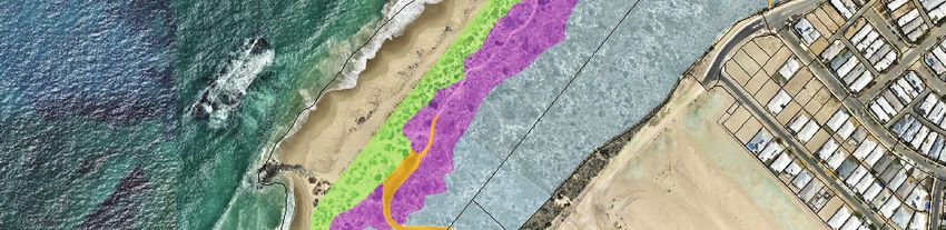
Table of Contents

Table of contents
Acronyms and abbreviations                                                                              i
1.    Introduction                                                                                     1
      1.1     Background                                                                               1
      1.2     Study Area                                                                               1
      1.3     Purpose and scope                                                                        5
      1.4     Objectives                                                                               5
      1.5     Document status                                                                          5

2.    Project overview                                                                                 7
      2.1     Foreshore planning and environmental approvals                                           7

3.    Statutory and policy context                                                                     8
      3.1     Strategic context                                                                        8
      3.2     Commonwealth government                                                                  8
            3.2.1   Environmental Protection and Biodiversity Conservation Act 1999                    8
            3.2.2   Perth and Peel Green Growth Plan                                                   8
      3.3     State government                                                                         9
            3.3.1   Metropolitan Region Scheme Amendment 975/33                                        9
            3.3.2   State Coastal Planning Policy 2.6                                                  9
            3.3.3   State Planning Policy 2.8 and Bush Forever                                        10
            3.3.4   Perth Coastal Planning Strategy                                                   10
            3.3.5   Environmental Protection Act 1986 (EP Act)                                        11
      3.4     Local government                                                                        11
            3.4.1   City of Wanneroo District Planning Scheme No. 2                                   11
            3.4.2   Yanchep – Two Rocks District Structure Plan                                       11
            3.4.3   Capricorn Coastal Village Agreed Structure Plan No. 44                            12
            3.4.4   Capricorn Coastal Node Agreed Structure Plan No. 75                               12
            3.4.5   City of Wanneroo Local Biodiversity Strategy                                      12
            3.4.6   City of Wanneroo Coastal Management Plan                                          13
            3.4.7   WAPC Subdivision approval                                                         13
            3.4.8   Local Planning Policy 4.21                                                        13

4.    Existing Environment                                                                           14
      4.1     Physical environment                                                                    14
            4.1.1   Climate                                                                           14
            4.1.2   Geology, landform and soils                                                       14
            4.1.3   Hydrology                                                                         16
            4.1.4   Flora and Vegetation                                                              18
            4.1.5   Fauna and fauna habitat                                                           25
            4.1.6   Social environment                                                                28
            4.1.7   Social values                                                                     30

5.    Coastal facilities demand                                                                      31
      5.1     Predicted Future Demand for Coastal Facilities                                          31
      5.2     Local Planning Policy 4.21                                                              32

6.    Foreshore development, design and function                                                     33
      6.1     Design vision                                                                           33
      6.2     Current foreshore and surrounding infrastructure                                        33
      6.3     Design concept - structural elements                                                    34
            6.3.1   Proposed key facilities                                                           35
            6.3.2   Proposed minor fixtures                                                           35
            6.3.3   Proposed play area                                                                36
            6.3.4   Lookout structures                                                                36
            6.3.5   Access paths and carpark                                                          36
            6.3.6   Conservation fencing                                                              36
            6.3.7   Surveillance                                                                      37
            6.3.8   Stormwater infrastructure                                                         37

7.    Coastal hazard risk management                                                                 41
      7.1     Coastal Aquatic Risk Assessment                                                         41
            7.1.1   Access and ongoing maintenance (Recommendation reference 1 and 2)                 43
            7.1.2   System of safety signage (Recommendation reference 3, 4 and 9)                    44

ADS16184_01 R001 Rev J
16-Aug-18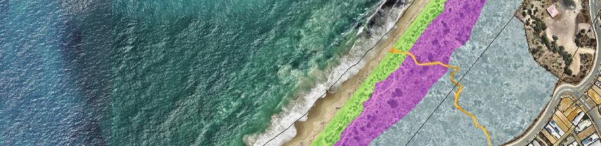
Table of Contents

             7.1.3     System of supervision (Recommendation reference 5)                               44
             7.1.4     Existence of emergency action plans (Recommendation reference 6)                 44
             7.1.5     Education and awareness (Recommendation reference 7 and 8)                       44
             7.1.6     Dune vegetation maintenance (Recommendation reference 10)                        44
      7.2      Coastal hazard risk                                                                      45
             7.2.1     North of the Capricorn Village Groyne                                            45
             7.2.2     South of the Capricorn Village Groyne                                            45
             7.2.3     Concluding comments                                                              46
      7.3      Coastal Hazard Risk Management and adaptation planning                                   46

8.    Management framework and responsibilities                                                        51
      8.1      Implementation                                                                           51
      8.2      Maintenance and practical completion                                                     51
      8.3      Handover                                                                                 52
      8.4      Timing                                                                                   52

9.    Foreshore management considerations                                                              53
      9.1      Flora, vegetation and weed management                                                    53
             9.1.1     Objectives, targets and key performance indicators                               53
             9.1.2     Management actions                                                               54
             9.1.3     Monitoring                                                                       55
             9.1.4     Contingencies                                                                    56
      9.2      Fauna                                                                                    57
             9.2.1     Objectives, targets and key performance indicators                               58
             9.2.2     Management actions                                                               58
             9.2.3     Monitoring and reporting                                                         60
             9.2.4     Contingencies                                                                    61
      9.3      Fire management                                                                          62
             9.3.1     Objectives, targets and key performance indicators                               62
             9.3.2     Construction stage                                                               62
             9.3.2.1   Management measures                                                              62
             9.3.2.2   Monitoring                                                                       63
             9.3.3     Post-construction stage                                                          64
      9.4      Revegetation management                                                                  65
             9.4.1     Objectives, targets and key performance indicators                               65
             9.4.2     Management actions                                                               67
             9.4.3     Species selection                                                                68
             9.4.4     Monitoring                                                                       69
             9.4.5     Contingencies                                                                    70
      9.5      Rehabilitation of earth-worked areas                                                     71
      9.6      Landscaping within POS                                                                   71
      9.7      Access and fencing                                                                       72
             9.7.1     Objectives, targets and key performance indicators                               72
             9.7.2     Management actions                                                               72
             9.7.3     Monitoring                                                                       73
             9.7.4     Contingencies                                                                    73
      9.8      Aboriginal heritage                                                                      74
      9.9      Public awareness and information management                                              74
             9.9.1     Community consultation                                                           75

10. Reporting and review                                                                               76
      10.1     Auditing and inspections                                                                 76
      10.2     Management plan review                                                                   76

11. References                                                                                         77

ADS16184_01 R001 Rev J
16-Aug-18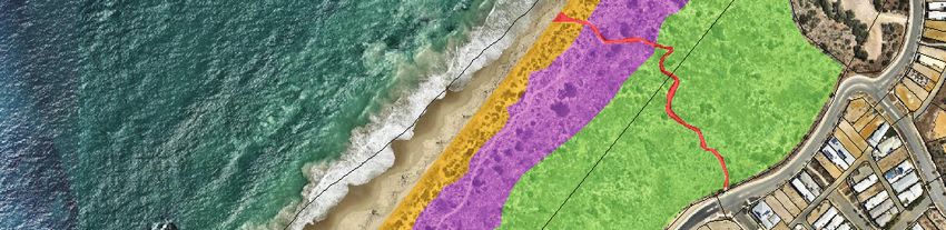
Table of Contents

List of tables
Table 1: Regional vegetation mapping                                                                                 18
Table 2: Threatened and Priority flora potentially occurring within the Study Area                                   19
Table 3: Vegetation Types                                                                                            21
Table 4: Area (ha) covered by each VT within the Study Area                                                          21
Table 5: Vegetation condition scale (Keighery 1994)                                                                  23
Table 6: Area (ha) covered by each vegetation condition category within the Study Area                               23
Table 7: Fauna assemblage                                                                                            26
Table 8: Conservation significant species recorded or with the potential to occur in the Study Area                  27
Table 9: Land use past and present for the Study Area                                                                28
Table 10: Yanchep-Two Rocks population predictions                                                                   31
Table 11: Beach usage by classification                                                                              31
Table 12: Current foreshore infrastructure                                                                           34
Table 13. Implementation of CARA report recommendations                                                              41
Table 14: Summary of Coastal Hazard Risk Management and Adaptation Measures                                          49
Table 15: Environmental objectives, targets and key performance indicators for flora, vegetation and weed
          management                                                                                                 54
Table 16: Management actions for flora, vegetation and weed management                                               54
Table 17: Flora, vegetation and weed management monitoring and reporting requirements                                55
Table 18: Flora, vegetation and weed management contingency measures                                                 56
Table 19: Environmental objectives, targets and indicators for fauna protection                                      58
Table 20: Management actions for fauna protection                                                                    58
Table 21: Monitoring actions for fauna protection                                                                    61
Table 22: Contingency actions for fauna protection                                                                   61
Table 23: Performance management targets and indicators for bush fire protection                                     62
Table 24: Management measures - construction stage                                                                   63
Table 25: Monitoring requirements - construction stage                                                               63
Table 26: Post-construction bushfire management measures                                                             64
Table 27: Environmental objectives, targets and indicators for revegetation                                          65
Table 28: Management actions for revegetation management                                                             67
Table 29: Species recorded from vegetation types within indicative revegetation areas                                69
Table 30: Monitoring actions for revegetation management                                                             69
Table 31: Contingency actions                                                                                        70
Table 32: Environmental objectives, targets and key performance indicators for access and infrastructure             72
Table 33: Access management actions                                                                                  73
Table 34: Access and infrastructure monitoring and reporting requirements                                            73
Table 35: Access management                                                                                          74
Table 36: Public awareness and information management actions                                                        75

List of figures
Figure 1:   Study Area                                                                                                2
Figure 2:   Surrounding planning approval boundary                                                                    3
Figure 3:   Tenure of the Study Area and Bush Forever                                                                 4
Figure 4:   Mean monthly climatic data (temperature and rainfall) for Gingin Aero Centre                             14
Figure 5:   Geology landform and soils of the Study Area                                                             17
Figure 6:   Vegetation Types mapped within the Study Area                                                            22
Figure 7:   Vegetation condition within the Study Area                                                               24
Figure 8:   Foreshore Masterplan                                                                                     39
Figure 9:   Indicative revegetation location within the Study Area                                                   66

ADS16184_01 R001 Rev J
16-Aug-18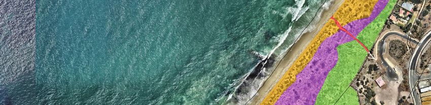
Table of Contents

List of appendices
Appendix 1 Subdivision approval (WAPC 155520)
Appendix 2 Karst Risk Assessment
Appendix 3 Level 2 flora and vegetation survey and supplementary survey
Appendix 4 Level 1 fauna survey
Appendix 5 Indicative fencing strategy
Appendix 6 Stormwater drainage design
Appendix 7 Coastal Risk Assessment and Recommendations: Capricorn Yanchep Development
Appendix 8 Capricorn Village Joint Venture: North Yanchep Coastal Erosion Hazard Review
Appendix 9 Coastal node adaptation plan
Appendix 10 Coastal node and POS landscape plans (concept plans subject to future approvals)

ADS16184_01 R001 Rev J
16-Aug-18
Capricorn Yanchep

Acronyms and abbreviations
 ASP                     Agreed Structure Plan
 AHD                     Australian Height Datum
 BoM                     Bureau of Meteorology
 CBC                     Carnaby's Black Cockatoo
 CoW                     City of Wanneroo
 CVJV                    Capricorn Village Joint Venture
 DEE                     Department of the Environment and Energy
 DPLH                    Department of Planning, Lands and Heritage
 DSP                     District Planning Scheme
 DWER                    Department of Water and Environment Regulation
 EP Act                  Environmental Protection Act 1986
 EPBC Act                Environmental Protection and Biodiversity Conservation Act 1999
 FMP                     Foreshore Management Plan
 GPS                     global positioning system
 IBRA                    Interim Biogeographic Regionalisation for Australia
 ILUA                    Indigenous Land Use Agreement
 LPP                     Local Planning Policy
 MNES                    matter of national environmental significance
 MRA                     MP Rogers and Associates
 MRS                     Metropolitan Region Scheme
 PCPS                    Perth Coastal Planning Strategy
 PEC                     Priority Ecological Community
 POS                     Public Open Space
 PPGGP                   Perth and Peel Green Growth Plan
 PR                      Parks and Recreation
 ROS                     Regional Open Space
 SPP                     State Planning Policy
 TEC                     Threatened Ecological Communities
 VT                      Vegetation Type
 WAPC                    Western Australian Planning Commission

ADS16184_01 R001 Rev J
16-Aug-18

Capricorn Yanchep
1. Introduction
1.1 Background
Capricorn Village Joint Venture (CVJV) is developing the Capricorn Coastal Village and Coastal Node
Precinct, located in Yanchep, Western Australia, approximately 51 km north of the Perth Central Business
District (CBD). The Capricorn Coastal Village and Coastal Node (the Project), incorporates Part Lot 312
and Lots 2, 303 and 304, Two Rocks Road, Yanchep, in the City of Wanneroo (CoW).
The Project will deliver approximately 2 500 dwelling units and include a primary school, shopping precinct,
tourism accommodation facility and a retirement village. The Capricorn Coastal Village Agreed Structure
Plan No. 44 was adopted by the CoW and Western Australia Planning Commission (WAPC) in 2012 and
development works have commenced with around 1 400 titled lots already developed.
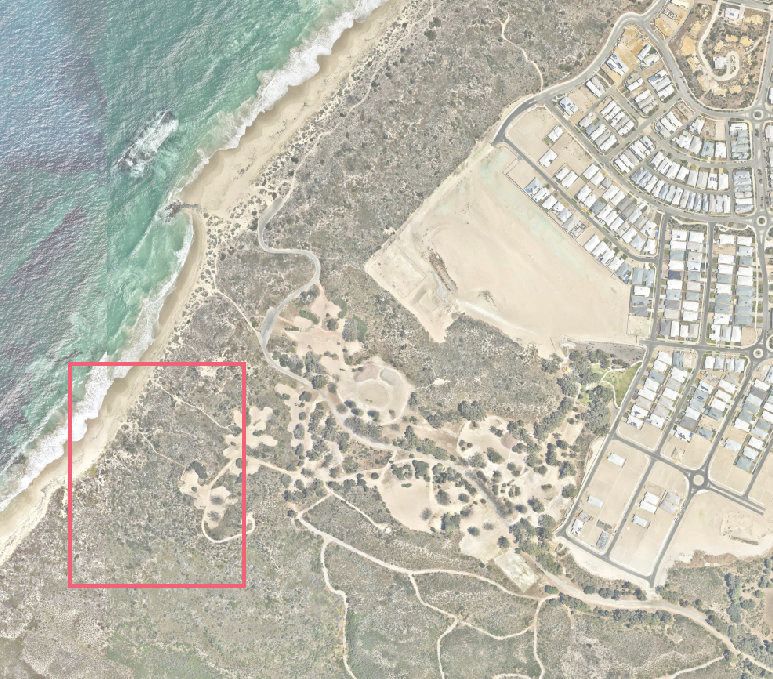
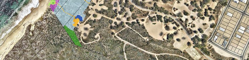
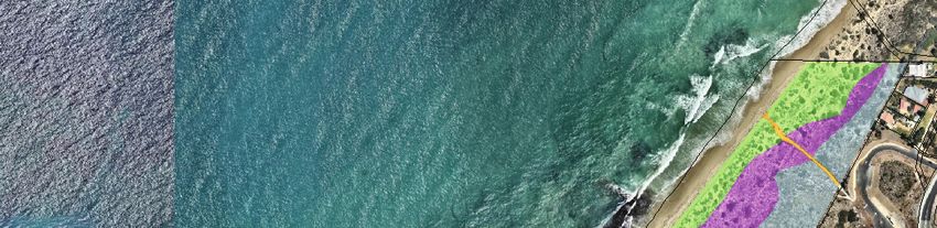
The Capricorn Foreshore Reserve (herein referred to as ‘the Study Area’) (Figure 1) provides a link
between the Indian Ocean and urban development and as such provides opportunity for conservation,
recreation and development purposes. As the developer, CVJV are required to prepare a Foreshore
Management Plan (FMP) to the satisfaction of the CoW, in accordance with Condition 13 of WAPC 155520
(Figure 2). The FMP will outline future development and management of the Study Area (Figure 1).
1.2 Study Area
The Study Area is approximately 1.3 km in length, 23.8 ha in area and includes the following reserves, as
shown on Figure 3:
1. R 32510 – north-east portion of the Study Area identified as ‘Parks and Recreation’ under MRS
zoning and ‘Regional Parks and Recreation’ under District Planning Scheme No. 2 (DPS 2).
2. Part Lot Reserve 20561 – western boundary of the Study Area identified as ‘Parks and Recreation’
under MRS zoning and ‘Regional Parks and Recreation’ under DPS 2.
3. Part Lot Reserve 48603 – Southeast portion of the Study Area identified as ‘Parks and Recreation’
under MRS zoning and ‘Regional Parks and Recreation’ under DPS 2.
4. Additional foreshore reserve as per WAPC155520 (reserve number to be determined).
The Study Area is bound to the east, by both existing and proposed areas of the Capricorn Coastal Village
and to the west by the Indian Ocean. The northern boundary of the Study Area extends to the Regional
Open Space (ROS) reserve 32510 boundary (comprising Lot 8999), while the southern boundary is bound
by Newman Park ‘A’ Reserve, comprising Yanchep Lagoon, and excludes Lot 661, comprising the Mary
Lindsay Homestead, freehold lots 132-135, Lots 8026 and 500 in reserve 4806 and Lots 501-502 in
reserve 29352.
The western portion of the CVJV landholding, which is reserved for Parks and Recreation under the
Metropolitan Region Scheme will be ceded to the Crown as a Foreshore Reserve at the time of subdivision
of the abutting land in accordance with WAPC policy DC 2.3 (WAPC 2002). Upon the transfer of the
foreshore to the Crown, the Study Area will be vested with the CoW. The CJVJ recently received
conditional subdivision approval (WAPC 155520; Figure 2; Appendix 1) which provides for the transfer of
the western portion of the CJVJ landholding to be transferred to the Crown as additional foreshore reserve.
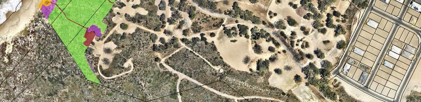
A large portion of the Study Area comprises of Bush Forever Site 397. Bush Forever Site 397 extends
beyond the Study Area, from Mindarie to north of Two Rocks (Figure 3).
ADS16184_01 R001 Rev J
16-Aug-18 1368800 369600
Overview map
6510400
6510400
GINGIN !
Project area
TWO ROCKS ! City of
YANCHEP ! Wanneroo
Indian Ocean JOONDALUP
!
(
STONEVILLE
! ! !
MUNDARING
! ! !
PERTH !
!
ROTTNEST ISLAND
6509600
6509600
6508800
6508800
368800 369600
Figure 1: Study area
Legend
¹
Scale 1:8,000 at A4
m
0 80 160 240
Cadastre
Coordinate System: GDA 1994 MGA Zone 50
Study area
Note that positional errors may occur in some areas
Date: 18/12/2017
info@strategen.com.au
Author: JCrute www.strategen.com.au
Source: NearMap: Aerial imagery - 2017; Landgate: Cadastre - 20171218.
Path: Q:\Consult\2016\ADS\ADS16184\ArcMap_documents\ADS16184_G006_RevA.mxd369000 370000
Parktree Av
ra Rd
Bia
Dr
Ch
d an
Kar
Be
er r
ach
ing
sid
St
e
Pd
e
Bu
n oL
Tw
oR
oc k
Bea
sR
d
chs
id eP
Rd
ting
de
rlas
Eve
W y
ush
arb
Sug
6510000
6510000
Wa
ise
ia R
ves
Zam
ki
Staghorn L
St
ho me Pde
Summer
Viridis D
Campgroun
Spinifex Loop
Footprint L
Explorer St Bluebell L
r
Carbon St
Light L
d Rd
Lookout Dr
ite Pl
L
Breaker St
Salt L Gran
cle
a yL
Drift L
rn St Wind
Ba ew
a rvi P Tide L
e e
Cl ar
l
Sh L Lindsay Beach Bvd
o re
Sunny Cl
Beachhaven Dr
v ie
Villalta Prom
Seasid
w
L
Sa
Kno
p
e
Reef L
ph
Langston Dr
Av
ire
l l Ri
L
se
Seadrift St
Board St
Le
Berte
Ledg
Surf a ux A p
S t p
C
ap
r ic
o rn
Es Yanch
e p B eac
p h Rd
6509000
6509000
Rd
ier
Ct
d
nR
az
ith
Br
Sm
a
wm
Ne
Av
ie
ilk
W
369000 370000
Figure 2: Surrounding planning approval boundaries
¹
Scale 1:10,000
at A4
Legend
m
0 100 200 300 Study area
Coordinate System: GDA 1994 MGA Zone 50
Note that positional errors may occur in some areas Capricorn Yanchep
Date: 18/12/2017
Author: JCrute Cadastre info@strategen.com.au
www.strategen.com.au
Source: Aerial image: nearma, flown 01/2017.
Existing cadastre: SLIP, Landgate 2017. Master plan: Client 03/2017.
Path: Q:\Consult\2016\ADS\ADS16184\ArcMap_documents\ADS16184_G007_RevA.mxd368500 369000 369500
Additional Foreshore
Reserve (WAPC 155520))
6510000
6510000
R 32510
Part Lot
6509500
6509500
R 20561
Site ID: 397
Part Lot
R 48603
6509000
6509000
368500 369000 369500
Figure 3: Tenure of the Study area and Bush Forever site
¹
Scale 1:8,000 at A4
Legend
m
0 80 160 240 Study area Bush Forever
Coordinate System: GDA 1994 MGA Zone 50
Note that positional errors may occur in some areas Cadastre
Date: 22/01/2018
Author: JCrute MRS parks and recreation reserve info@strategen.com.au
www.strategen.com.au
Source: Aerial image: nearmap, flown 01/2017.
Existing cadastre: SLIP, Landgate 2017. Master plan: Client 03/2017. Bush Forever sites: DoP, 2012.
Path: Q:\Consult\2016\ADS\ADS16184\ArcMap_documents\ADS16184_G008_RevD.mxdCapricorn Yanchep
1.3 Purpose and scope
The purpose of this FMP is to guide the management of the Study Area. The FMP identifies opportunities
for facilities and amenities to be developed in the foreshore reserve to allow interaction with the coastline,
whilst providing a management framework to ensure the ecological features of the foreshore reserve are
conserved and protected.
The FMP has specifically been prepared to fulfil the requirement of Local Structure Plan 75 (ASP 75),
Local Structure Plan 44 (ASP 44) and existing subdivision approvals, as summarised in section 3.4.
This FMP provides an overview of the proposed foreshore development and outlines key management
measures to be implemented to protect values of the Study Area. The FMP has been set out with the
following structure:
• Project overview (Section 2)
• Statutory and policy context (Section 3)
• Existing environment (Section 4)
• Coastal facilities demand (Section 5)
• Foreshore development, design and function (Section 6)
• Coastal hazard risk management (Section 7)
• Management framework and responsibilities (Section 8)
• Foreshore management considerations (Section 9)
• Reporting and review (Section 10).
1.4 Objectives
The overarching objective of this FMP is to protect and conserve the existing environmental values of the
Study Area whilst facilitating the development of complementary recreational facilities and providing
controlled access to and within the foreshore reserve. The following key objectives underpin this FMP:
1. Ensure the Study Area is developed in accordance with relevant planning and environmental
approvals, planning policies and guidelines.
2. Retain and conserve vegetation and habitat of high environmental value where possible.
3. Manage places of environmental and heritage significance to the satisfaction of the community and
key stakeholders.
4. Introduce infrastructure and recreational facilities while ensuring ecological features of the Study Area
are not compromised.
1.5 Document status
An FMP was initially prepared by ATA Environmental (now Coffey Environments) in 2004 to support the
Capricorn Coastal Village Structure Plan (ASP 44). The document was then revised and updated in May
2007 by the CoW, incorporating foreshore management for the Two Rocks Yanchep area. The document
was adopted by the CoW, however was not approved by the WAPC (as previously required under expired
subdivision approval WAPC 138089). The Department of Planning, Lands and Heritage (DPLH) provided
comments on the Two Rocks Yanchep FMP in June 2010; however, despite ongoing consultation, the
document was not formally updated and approved due to a number of concerns not being able to be
addressed at the time.
The FMP was then updated in March 2017, following a series of discussions with DPLH (held on
10 May 2016) and CoW (held on 10 May 2016; 21 September 2016; 15 March 2017). The revised FMP
considered previous comments and considerations on the FMP, the latest relevant planning policies and
guidelines including SPP 2.6 (WAPC 2013a) and additional environmental, planning and social
investigations undertaken in support of the Capricorn development.
ADS16184_01 R001 Rev J
16-Aug-18 5Capricorn Yanchep Following submission of the FMP a series of comments were provided by DPLH and CoW on 2 May 2017 and 5 May 2017 and 9 May 2017 respectively. This version of the FMP has been prepared in consideration of all DPLH and CoW comments to date. Since the time that the above-mentioned comments were received, the CVJV have received subdivision approval (WAPC 155520; Figure 2; Appendix 1). As outlined in Section 1.2 the subdivision approval provides for the transfer of the western portion of the CJVJ landholding to be transferred to the Crown as additional foreshore reserve. The FMP has been updated to include this additional area, which has included an additional flora and vegetation survey to capture the ecological values of this area. ADS16184_01 R001 Rev J 16-Aug-18 6
Capricorn Yanchep

2.           Project overview
The proposed foreshore development comprises the Coastal Node Public Open Space (POS), which
represents the key infrastructure component to be developed within the foreshore reserve. In addition to
the POS, existing beach access points will be formalised within the Study Area as part of the Coastal Node
POS development.

Structural and design elements of the POS and beach access points have been developed based on
several key considerations, including the following:
      •     demand associated with regional and local context of the site
      •     coastal hazard and risk management
      •     environmental site characteristics, including vegetation, flora, fauna, topography and landform
            function
      •     maximising previously disturbed areas
      •     management considerations.

The proposed Foreshore Masterplan and Foreshore Concept Plan that underpin the FMP are described in
detail in the supporting Development Application. An overview of foreshore design, development and
function is detailed further in Section 6.

2.1          Foreshore planning and environmental approvals
The FMP will require the approval of CoW in accordance with the current subdivision approval (WAPC
155520).

The proposed development works within the Study Area will be subject to the following planning and
environmental approvals:
1.    Development Application (CoW and WAPC).
2.    Engineering/landscape construction design drawings (CoW).
3.    Purpose Permit clearing application approval (Department of Water and Environmental Regulation
      [DWER]).
4.    Section 18 clearance if development is proposed within a registered Aboriginal Heritage site
      (Department of Aboriginal Affairs).

The Study Area will be zoned as ‘Parks and Recreation’ reserve and vested to the Crown as agreed by
CVJV and the WAPC. Upon transfer of the foreshore to the Crown, the foreshore will be vested in the
CoW.

ADS16184_01 R001 Rev J
16-Aug-18                                               7
Capricorn Yanchep
3. Statutory and policy context
Key statutory and policy documents relevant to the Project are described in detail in the following sections.
3.1 Strategic context
The requirement to prepare and implement an FMP is established by the following statutory and policy
mechanisms at the Commonwealth, State and Local Government levels:
• Environmental Protection and Biodiversity Conservation Act (EPBC Act) 1999
• MRS Amendment 975/33
• State Coastal Planning Policy 2.6
• State Planning Policy 2.8: Bushland Policy for the Perth Metropolitan Region
• Perth Coastal Planning Strategy
• City of Wanneroo District Planning Scheme No. 2
• Yanchep – Two Rocks District Structure Plan
• Capricorn Coastal Village Agreed Structure Plan No 44
• Capricorn Coastal Node Structure Plan No. 75
• City of Wanneroo Local Biodiversity Strategy
• City of Wanneroo Coastal Management Plan
• WAPC subdivision approval 155520 (Condition 13).
These mechanisms are described in further detail below.
3.2 Commonwealth government
3.2.1 Environmental Protection and Biodiversity Conservation Act 1999
Under the EPBC Act, actions that have, or are likely to have, a significant impact on a matter of national
environmental significance (MNES), require approval from the Commonwealth Minister for the
Environmental (DEE 2016).
Development within the Study Area will result in the clearance of approximately 1.72 ha of vegetation that
comprises some foraging habitat but a lack of suitable plant species for Carnaby's Black Cockatoo (CBC),
a MNES. The fauna assessment (Bamford Consulting Ecologists 2017) suggested that CBC is an irregular
non-breeding visitor to the area.
The proponent has considered their obligations under the EPBC Act through consultation with an
environmental consultant in consideration of the Referral guidelines for three threatened black cockatoo
species (DSEWPaC 2012) (including the draft revised version DEE 2017). The proposed clearing is not
expected to result in a significant impact to CBC; therefore, the proposed foreshore development will not
be referred to the Department of the Environment and Energy (DEE) for assessment under the EPBC Act.
3.2.2 Perth and Peel Green Growth Plan
The Perth and Peel Green Growth Plan (PPGGP) is a joint initiative between the Commonwealth and
State Government of Western Australia initiated in 2011 by the Western Australian Ministers for Planning
and Environment and the Commonwealth Minister for the Environment. As communicated at the time and
reiterated by the Department of Premier and Cabinet at the release of the PPGGP, one of the primary
motivations for the State Government to undertake the Strategic Assessment was to remove the
Commonwealth from decision making on small projects within the Perth and Peel regions. This was
particularly relevant to projects impacting black cockatoo habitat, where, at the time, the Commonwealth
were requiring referral, and in some cases assessment, of projects with as little impact as 1 ha of habitat.
ADS16184_01 R001 Rev J
16-Aug-18 8Capricorn Yanchep
The proposed foreshore development is unlikely to result in an impact to MNES and the anticipated impact
to vegetation within the Study Area is not considered to be significant, therefore consideration under the
EPBC Act and PPGGP will not be required. In accordance with current draft PPGGP mapping, the Study
Area does not comprise any urban, industrial or rural residential ‘classes of actions’ and currently no ‘broad
commitments’ have been identified from within the Study Area boundary.
As the PPGGP is currently in draft format, the proposed foreshore development will be assessed via the
current planning and environmental approvals pathways, including planning approval from CoW and
WAPC and approval to clear under the provisions of the EP Act, as detailed in Section 2.1.
3.3 State government
3.3.1 Metropolitan Region Scheme Amendment 975/33
In 1996, the Yanchep Two Rocks (St Andrews) MRS Amendment 975/33 rezoned approximately 4 200 ha
of land owned by the Tokyu Corporation to Urban and Urban Deferred zones to facilitate future
development and give effect to the Yanchep Structure Plan.
A key part or this amendment, involved reserving coastal foreshore land as Parks and Recreation (PR)
and the ceding of land by Tokyu Corporation to the Crown free of charge. The foreshore reserve boundary
was determined in 1996 by the amendment, based on the Coastal Planning Strategy prepared for the
Yanchep-Two Rocks area. The Yanchep precinct and associated foreshore reserve requires the provision
of well-considered and adequate coastal facilities and access, which is acknowledged in the Perth Coastal
Planning Strategy (PCPS), detailed further in Section 3.3.4.
The MRS outlines a number of clauses under which reserved land owned or vested in a public authority
can be developed without the written approval of the Commission (WAPC). Given that the proposed
foreshore area is Bush Forever, representing regionally significant vegetation, this clause does not apply
and approval by the WAPC is required via a Development Application (as discussed in section 2.1).
3.3.2 State Coastal Planning Policy 2.6
State Coastal Planning Policy 2.6 (SPP 2.6; WAPC 2013b) applies to coastal planning proposals from
broad structure planning through to detailed development proposals throughout Western Australia. The
objectives of SPP 2.6 are to:
• ensure that the location of coastal facilities takes into account coastal processes, landform
stability, coastal hazards, climate change and biophysical criteria
• ensure the identification of appropriate areas for the sustainable use of the coast for housing,
tourism, recreation, ocean access, maritime industry, commercial and other activities
• provide for public coastal foreshore reserves and access to them on the coast
• protect, conserve and enhance coastal zone values, particularly in areas of landscape,
biodiversity and ecosystem integrity, indigenous and cultural significance.
Coastal land is required to be set aside for public use including conservation, management, public access
and recreation, in accordance with SPP 2.6. SPP 2.6 also states that coastal Foreshore Management
Plans or strategies are required at an appropriate phase of planning or development approval (dependant
on the scale of development) for the reserved land and any adjacent freehold land with conservation value.
To reduce the risk of damage as a result of coastal processes, SPP 2.6 outlines the requirements in terms
of the application of coastal foreshore reserves and development setbacks from coastal features or
physical processes.
ADS16184_01 R001 Rev J
16-Aug-18 9Capricorn Yanchep
SPP 2.6 recognises that in some circumstances development may need to occur in areas potentially
impacted by physical coastal processes within certain planning time frames. These circumstances may
include:
• public recreation facilities with finite life spans
• coastally dependent and easily relocatable development
• Department of Defence
• industrial and commercial development
• coastal nodes
• surf life saving clubs.
The proposed works for the Study Area are consistent with three of the circumstances listed above and is
therefore able to proceed (pending relevant approvals once adequate management and adaption planning
measures have been included, which are consistent with the policy provisions of SPP 2.6 (WAPC 2013a),
as detailed in Section 6 and 7.
3.3.3 State Planning Policy 2.8 and Bush Forever
State Planning Policy 2.8: Bushland Policy for the Perth Metropolitan Region (SPP 2.8, WAPC 2010) aims
to provide a policy and implementation framework that ensures bushland protection and management
issues throughout the Perth Metropolitan Region are adequately addressed and integrated with broader
land use planning and decision-making (WAPC 2010). The policy predominantly deals with two distinct
subjects, Bush Forever areas and local bushland areas.
The majority of the Study Area comprises Bush Forever Site 397. A small portion of native vegetation
within the Study Area will be cleared to facilitate construction of access and commercial facilities within the
foreshore reserve. A native vegetation clearing permit has been lodged with the DWER for the clearing of
approximately 2.4 ha of native vegetation as outlined in Section 3.3.5. The native vegetation clearing
permit application includes an assessment of potential impacts to the Bush Forever site under Schedule 5
of the EP Act, namely ‘principle h’. DWER will determine if the impacts to the Bush Forever site resulting
from the coastal node development are considered significant, and will advise on any requirements to
offset these impacts. No clearing will be undertaken within the Bush Forever site until DWER have granted
the clearing permit. It is noted that the native vegetation clearing permit will not be formally granted by
DWER until both the FMP and associated Development Application have been approved by CoW.
In accordance with SPP 2.8, proposals must recognise regionally significant bushland and outline methods
by which it will avoid, minimise and offset any likely adverse impacts it will have on regionally significant
bushland. Opportunities to rehabilitate disturbed areas within the Study Area have been identified, as
discussed in Section 9.4.
3.3.4 Perth Coastal Planning Strategy
The Perth Coastal Planning Strategy (PCPS) was developed to encourage better planning and protection
of the Perth Metropolitan Coastline. The strategy promotes integrated coastal zone management and
provides guidance for the location, scale and density of developments appropriate for the Perth coastline
over the next 10 to 15 years.
The strategy applies to the coastal zone in the MRS from Two Rocks to Singleton, extending from 500 m
offshore to the first main road running parallel to the coast. The WAPC endorsed amendments to the
PCPS in January 2010 and resolved to endorse PCPS as an input into the next phase of Directions 2031,
including structure planning, ensuring the centres contained within PCPS precincts are appropriate and
complementary to the Directions 2031 activity centres hierarchy. The Study Area is located within
Precinct 5 of the PCPS and identified as ‘mixed use’.
ADS16184_01 R001 Rev J
16-Aug-18 10Capricorn Yanchep
3.3.5 Environmental Protection Act 1986 (EP Act)
Clearing of native vegetation is regulated under Part V of the EP Act. Prior to clearing native vegetation, a
clearing permit must be obtained from the Department of Water and Environment Regulation (DWER)
unless a valid exemption applies.
Clearing proposed within the Study Area requires CVJV to obtain a clearing permit, with the exception of
clearing associated with the proposed ‘dual use path’, for which a valid exemption applies. Clearing
associated with the dual use path is considered to be exempt via the subdivision approval (WAPC 155520)
as the DUP is depicted on the plan of subdivision, and is required to be constructed by the Commission
under Condition 18 of the approval which states:
‘Engineering drawings and specifications are to be submitted, approved, and subdivisional works
undertaken in accordance with the approved plan of subdivision, engineering drawings and specifications,
for the provision of shared paths through and connecting to the application area in accordance with the
plan dated 20 November 2017 (attached). The approved shared paths are to be constructed by the
landowner/applicant. (Local Government)’.
A native vegetation clearing permit application, for clearing within the Study Area (associated with the
Coastal Node development) was lodged with DWER on 11th October 2017 and is currently being
assessed. No clearing will be undertaken in the Study Area until the clearing permit has been granted or
alternatively a valid exemption applies.
It is noted that the native vegetation clearing permit will not be formally granted by DWER until both the
FMP and associated Development Application have been approved by CoW.
3.4 Local government
3.4.1 City of Wanneroo District Planning Scheme No. 2
The CoW District Planning Scheme (DPS) was amended in 2000 (Amendment No. 787), resulting in
reclassification of the majority of the DPS land to ‘Urban Development’ to facilitate urban growth in an
orderly and managed way. Section 48 of the Environmental Protection Act 1986 (EP Act) required an
Environmental Review to be prepared for the amendment to be assessed by the EPA. The Environmental
Review identified a number of management conditions to be implemented at various stages of the
planning process.
Environmental conditions imposed through Amendment No. 787 are set out under Schedule 9 of the CoW
DPS 2. DPS No. 2 describes the zoning of land within CoW, specifying where certain land uses are
permitted and sets standards for development. The Study Area is zoned ‘Regional Parks and Recreation’
in accordance with the CoW DPS No. 2. In accordance with Schedule 9 of the CoW DPS 2, a coastal
foreshore management plan is required to be prepared.
3.4.2 Yanchep – Two Rocks District Structure Plan
The Yanchep–Two Rocks District Structure Plan (Roberts Day 2010) provides a framework for the
development of urban villages, centres for education, industry, technology and enterprise, regional open
spaces and city centres, all connected via a network of paths and roads.
Section 7.2 of Part 1 (Statutory Provisions) of the Yanchep – Two Rocks District Structure Plan states that:
The precise size, nature and location of the development nodes and coastal setback zones and
the provision of recreation facilities and amenities will be address as part of the LSPs. Foreshore
Management Plans will also be prepared as part of the LSP’s to ensure that development
adjacent to the coast provides a balance between protection of the environment and sustainable
development.
ADS16184_01 R001 Rev J
16-Aug-18 11Capricorn Yanchep
The foreshore will be developed in consideration of the Yanchep-Two Rocks DSP, including the
requirement to prepare an FMP.
3.4.3 Capricorn Coastal Village Agreed Structure Plan No. 44
Part 8 (special provisions) of Part 1of the Capricorn Coastal Village Agreed Structure Plan No. 44 (CoW
2012) (ASP 44) states that:
Lots 303 and 304 within the Project Area are subject to Environmental Conditions which require
the preparation of the following relevant Environmental Management Plans:
Drainage, Nutrient and Water Management Plan
Foreshore Management Plan.
In accordance with the Structure Plan, ATA Environmental prepared a draft Foreshore Management Plan
in 2004 which was updated in 2007 by the CoW. This current FMP has been prepared in place of the draft
FMP and will be implemented to the satisfaction of the CoW.
3.4.4 Capricorn Coastal Node Agreed Structure Plan No. 75
The Capricorn Coastal Node Agreed Structure Plan No. 75 (TBB 2015) (ASP 75) provides the planning
framework to guide subsequent detailed urban design and development of the Capricorn Coastal Node.
The Structure Plan has been prepared pursuant to the CoW DPS 2. The Capricorn development occurs
adjacent to the eastern boundary of the Study Area, as detailed in Figure 2.
In accordance with Section 1.12 of ASP 75, a Foreshore Development Concept must be prepared as a
condition of subdivision, where public access to the coastal foreshore reserve is made available,
specifically:
Foreshore Management Plan – Lodgement of subdivision or development within the Mixed Use
Zone where adjacent to the Coastal Foreshore Reserve.
Furthermore, ASP 75 requires an FMP as a condition of subdivision approval where public access to the
Coastal Foreshore Reserve is made available. The main purpose is therefore to provide a development
concept for a coastal activity node in the foreshore reserve for the use of existing and future residents (as
provided for in the approved adjacent structure plans) and provide for the management of this coastal
activity node, prior to public access being provided through subdivision or development adjacent to it.
ASP 75 details the type of development permissible immediately adjacent to the Study Area and that it
must:
• maintain public accessibility to the Study Area
• maintain a visual connection to the coast from the foreshore road and in strategic locations
• be sympathetic to the coastal environment and landscape.
This FMP has been prepared to satisfy this requirement.
3.4.5 City of Wanneroo Local Biodiversity Strategy
The CoW Local Biodiversity Strategy (2011) was developed to guide the planning of growth within the
CoW, with specific targets to reduce the loss of natural areas and improve biodiversity protection. The
report sets out a number of targets and strategies for CoW to implement, guiding development and
biodiversity in CoW over the years from 2011–2016. The strategy is currently being updated by the CoW.
The development of the Study Area contributes to the objectives of the Local Biodiversity Strategy through
the contribution of additional foreshore reserve as PR reserve, as well as increased protection of
ecological values through conservation fencing, rehabilitation, weed control and formalisation of access-
ways.
ADS16184_01 R001 Rev J
16-Aug-18 12Capricorn Yanchep
3.4.6 City of Wanneroo Coastal Management Plan
Part 1 of the CoW Coastal Management Plan (CoW 2012) provides an overview of current and future
coastal land use from Tamala Park to Two Rocks. The plan enables CoW to focus on research and
ultimately allow for effective planning, implementation and management of recreation and conservation of
coastal areas and coastal assets now and into the future (CoW 2012).
The Coastal Management Plan outlines potential future uses for the Capricorn coastal region. These
include:
• two picnic/recreation areas
• dual use path parallel to the foreshore/board walk and beach access
• beach access ways including associated car parking, lookouts, signage, bins and bike racks
• investigations into proposed uses of the Lindsay Homestead
• Capricorn Boulevard extension
• proposed boardwalk and beach access
• extra access from Lindsay homestead.
Requirements detailed in Part 1 of the Coastal Management Plan have either been developed or are
proposed to be constructed as detailed further in Section 6 of this FMP and the supporting DA.
Part 2 of the CoW Coastal Management Plan is yet to be finalised however intends to provide additional
information on the potential adaption of existing management regimes as the CoW evolves and guide
future development to ensure the sustainable use of the coastline (CoW 2016b).
3.4.7 WAPC Subdivision approval
In accordance with subdivision Condition 13 of WAPC 155520, CVJV is required to prepare a Foreshore
Management Plan as follows:
Prior to the commencement of subdivision works a foreshore management plan for the coastal
foreshore reserve is to be prepared and approved to ensure the protection and management of
the sites environmental assets with satisfactory arrangements being made for the implementation
of the approved plan (Local Government).
This FMP has been prepared to satisfy the above subdivision condition.
3.4.8 Local Planning Policy 4.21
The CoW LPP 4.21 Coastal Assets Policy (CoW 2016) is a key guiding document utilised in the
preparation of this FMP and supporting DA. The policy complements SPP 2.6 and associated guidelines
and has been utilised in conjunction with these documents to inform the assessment and adaptation
planning for the proposed coastal assets.
The relationship between the proposed foreshore infrastructure and LPP 4.21 has been summarised
further in Section 3.4.8 and the supporting DA.
ADS16184_01 R001 Rev J
16-Aug-18 13Capricorn Yanchep
4. Existing Environment
4.1 Physical environment
4.1.1 Climate
The Yanchep locality experiences a Mediterranean climate characterised by mild, wet winters and warm to
hot, dry summers. The nearest Bureau of Meteorology (BoM) weather station at Gingin Aero weather
Station (Station No. 009178) provides average monthly climate statistics for the Yanchep locality
(Figure 4). Average annual rainfall recorded at Yanchep since 1996 is 620.2 mm (BoM 2016). Rainfall
may occur at any time of year; however, most occurs in winter in association with cold fronts from the
southwest. Highest temperatures occur between December and March, with average monthly maximums
ranging from 30.6°C in December to 33.3 in February (BoM 2016). Lowest temperatures occur between
June and September, with average monthly minimums ranging from 6.2°C in July and August to 7.5°C in
September (BoM 2016).
40 140
Average Rainfall at Gingin Aero [mm]
Average Minimum Temperature at Gingin Aero [°C]
35
120
Average Maximum Temperature at Gingin Aero [°C]
30
100
Rainfall and Evaporation (mm)
25
Temperature [°C]
80
20
60
15
40
10
20
5
0 0
Jan Feb Mar Apr May Jun Jul Aug Sept Oct Nov Dec
Figure 4: Mean monthly climatic data (temperature and rainfall) for Gingin Aero Centre
4.1.2 Geology, landform and soils
Geology
The Study Area is located within the Perth Basin, a geological formation that spans from the southern
boundary of the Carnarvon Basin in the north and Cape Leeuwin in the south and extends to
approximately 10 km thick (ATA 2007).
The surface geology of the Study Area is dominated by Safety Bay Sand overlying Tamala Limestone.
Safety Bay Sand is comprised of a mixture of coastal dune sand and shallow marine eolian sands with its
distribution aligning with the Quindalup Dunal System. Safety Bay sand is still productively accumulating
along the coastline. Tamala Limestone is a unit of friable to hard, medium grained eolian calcarenite
composed of wind-blown shell fragments with variable amounts of quartz sand (ATA 2007).
ADS16184_01 R001 Rev J
16-Aug-18 14Capricorn Yanchep
Landform
The Study Area is characterised by an undulating dunal system running discontinuously parallel to the
coast which consists primarily of a large primary dune fronted by a reasonably sized foredune. The
primary dune maintains a typical elevation of 15–20 mAHD (MRA 2014). The foredune has a typical
elevation of 5–6 mAHD with a maximum width of approximately 75 m in the northern boundary of the
Study Area, becoming narrower further south. Between the beach and tall dunal system lies a foredune
areas consisting of low, narrow beach ridges and swales. Two ridges are also present running east–west
from the frontal primary dune creating a broad, deep valley between them (ATA 2004).
Karst risk
A karst risk desktop study was undertaken by Galt Geotechnics (Galt 2016; Appendix 2) in accordance
with Local Planning Policy 4.13: Caves and Karstic Features (CoW 2016c) to support the FMP. The
objectives of the study were to:
• conduct a karst risk desk study along the foreshore of the Capricorn Yanchep project (area
nominated on provided plans), in line with City of Wanneroo planning requirements, including a
map showing areas of karst risk
• provide advice on further geotechnical investigations (if required) to support a Karst Risk
Management Plan.
The CoW karst risk mapping identifies the Study Area as occurring within a 'low karst risk' zone
(Galt 2016). The study concluded that a Karstic Features Management Plan is not required to support the
proposed development, however notes that geotechnical studies will be required within the Study Area
where structures, such as changerooms, toilet facilities etc are proposed to certify that the land is capable
of development (Galt 2016). The requirement for a geotechnical investigation is not specifically related to
karst risk, but is required as part of standard pre-development requirements (Galt 2016).
Soils
The Study Area features an undulating coastal Quindalup dune system which extends from Geographe
Bay in the south to Dongara in the north and features a series of large scale, elongated and coalescent
parabolic dunes (ATA 2007).
Soil mapping undertaken for the Perth Metropolitan Region (Gozzard 1982), identified one soil type within
the Study Area:
• S2: Calcareous Sand – white, fine to medium grained, sub-rounded quartz and shell debris, of
eolian origin.
The soil mapping of the Study Area is presented in (Figure 5).
Contamination risk
Strategen Environmental (Strategen) undertook an assessment of soil beneath the historic Club Capricorn
infrastructure to determine if residual pesticide is present as a result of regular application of white ant
treatment (Strategen 2016a).
The assessment included sampling of soil from three chalets and former kiosk area. Results of the
assessment found that persistent organochlorine (OC) and organophosphate (OP) pesticides were not
present in shallow samples, excluding the following in low concentrations:
• Aldrin
• Chlordane
• Dieldrin
• Heptachlor
• Oxychlordane.
ADS16184_01 R001 Rev J
16-Aug-18 15Capricorn Yanchep The quantities of the OC/OP pesticides described above were compared to the National Environmental Protection Council (2013) National Environmental Protection (Assessment of site contamination) Amendment Measure (NEPM) which found that the concentrations did not exceed the guidelines. In consideration of the results, the assessment concluded that no specific contamination management was required during demolition of the buildings (Strategen 2016a). 4.1.3 Hydrology A review of the Department of Water Perth Groundwater Mapping (2016) indicates that groundwater flows is in a westerly direction towards the coastline. Groundwater in the Study Area ranges from 0 m Australian Height Datum (AHD) along the coastline to a maximum of 1 mAHD in the east of the Study Area. A search of the Swan Coastal Plain geomorphic wetlands map (Landgate 2016 [search conducted 26 August 2016]) did not identify any wetlands within the Study Area. The nearest wetland is found is approximately 5 km to the east of the Study Area. ADS16184_01 R001 Rev J 16-Aug-18 16
368400                                                                          369600

                                                                                                                                    LS4
                                                                                              LS1

                                                                                                                                           S7

                                                                                                                                                       LS1

                                                                                                                                                                            S7
6510000

                                                                                                                                                                                     6510000
                                                                                                                   S2

                                                                                                                                                             LS4

                                                                                                                                                               LS1

                                                                                                                                                                            S7
6508800

                                                                                                                                                                                     6508800

                 Surface geology
                           LS1: LIMESTONE - light yellowish brown, fine to coarse-grained, sub-angular to well rounded, quartz, trace of
                           feldspar, shell debris, variably lithified, surface kankar, of eolian origin
                           LS4: LIMESTONE - light yellowish brown, fine to coarse-grained, sub-angular to well rounded, quartz, trace of
                           feldspar, shell debris, variably lithified, surface kankar, of eolian origin, abundant karstic
                           S1: CALCAREOUS SAND - white, fine to medium-grained, sub-rounded quartz and shell debris, of eolian origin
                           S2: CALCAREOUS SAND - white, fine to medium-grained, sub-rounded quartz and shell debris, of eolian origin
                           S7: ND - pale and olive yellow, medium to coarse-grained, sub-angular quartz with a trace of feldspar,
                           moderately sorted, of residual origin
                                                                                                                                                  S1

                                                                368400                                                                          369600

          Figure 5: Geology, soils and landform of the study area
                                                                           Legend

                                                          ¹
          Scale 1:12,000     at A4

                                                m                                    Study area
          0          120             240      360

          Coordinate System: GDA 1994 MGA Zone 50                                    Existing cadastre
          Note that positional errors may occur in some areas
          Date: 18/12/2017
                                                                                                                                                             info@strategen.com.au
          Author: JCrute                                                                                                                                     www.strategen.com.au
          Source: Aerial image: nearmap, flown 01/2017. Existing cadastre: SLIP, Landgate 2017.
          Master plan: Client 03/2017. Geology: Yanchep map sheet, 1:50000, DMP, 2014.
          Path: Q:\Consult\2016\ADS\ADS16184\ArcMap_documents\ADS16184_G009_RevA.mxd
Capricorn Yanchep
4.1.4 Flora and Vegetation
Desktop assessment
Regional vegetation
Vegetation of the region has been mapped at a broad scale as part of regional mapping undertaken since
the 1970s, notably as part of Beard (1990) mapping. The Beard mapping has formed the basis of several
regional mapping systems, including physiographic regions defined by Beard (1981) which led to the
delineation of botanical districts as described in Beard (1990); the biogeographical region dataset (Interim
Biogeographic Regionalisation for Australia, IBRA) for Western Australia (DEE 2015a) and System 6
Vegetation Complex mapping undertaken by Heddle et al. (1980).
A summary of the regional vegetation mapping comprising the Study Area is presented in Table 1.
Table 1: Regional vegetation mapping
Regional mapping Vegetation system Description
Beard 1990 Drummond Low Banksia woodlands on leached sands; Melaleuca swamps on
Botanical poorly-drained depressions; and Eucalyptus gomphocephala (Tuart),
Subdistrict Eucalyptus marginata (Jarrah) and Corymbia calophylla (Marri)
woodlands on less leached soils.
IBRA Swan Coastal Banksia or Tuart on sandy soils, Casuarina obesa on outwash plains
Plain 2 IBRA and paperbark (Melaleuca) in swampy areas.
subregion
System 6 and Quindalup Coastal dune complex consisting mainly of two alliances – the strand
vegetation system Complex and fore dune alliance and the mobile and stable dune alliance. Local
association mapping variations include the low closed forest of M. Lanceolata – Callitris
preissii and the closed scrub of Acacia rostellifera.
Guilderton 1007 Mosaic: Shrublands; Acacia lasiocarpa and Melaleuca acerosa heath /
vegetation system Shrublands; Acacia rostellifera and Acacia cyclops thicket.
association
Threatened and Priority flora
A desktop survey for Threatened and Priority flora that may potentially occur within the Study Area was
undertaken using NatureMap (Parks and Wildlife 2007-), the Western Australian Herbarium (Western
Australian Herbarium 1998-), and the DEE Protected Matters Search Tool (DEE 2015c).
Table 2 shows the Threatened and Priority flora potentially occurring within the Study Area based on the
desktop search results. The desktop assessment identified one Threatened flora and three Priority flora
species that have been recorded in the regional area. Of these, based on specific habitat requirements,
no Threatened flora species and two Priority flora species have the potential to occur within the Study
Area, including:
• Leucopogon maritimus (P1)
• Stylidium maritimum (P3).
ADS16184_01 R001 Rev J
16-Aug-18 18Capricorn Yanchep
Table 2: Threatened and Priority flora potentially occurring within the Study Area
Conservation status
Species Description Potential to occur
EPBC Act WC Act
Eucalyptus Threatened Threatened Mallee to 4 m tall with smooth bark. Flowers Unlikely – Preferred
argutifolia – are white and visible March to April. Habitat soil type/habitat does
(Wabling Hill Vulnerable for this species occurs within shallow soils not occur within the
Mallee) over limestone, on slopes or gullies of Study Area.
limestone ridges and outcrops (Western
Australian Herbarium 1998-).
Leucopogon Not listed Priority 1 A low, spreading shrubs to 40 cm tall and 60 Possible – Preferred
maritimus cm wide, often multi-stemmed close to the habitat exists within
(Coast base but single-stemmed at ground level with the Study Area.
Beard- a fire-sensitive rootstock. Leucopogon
heath) maritimus is restricted to near-coastal
Quindalup dunes, from a small area of
coastline about 40–70 km north of Perth. It
occurs in deep, calcareous sands, on the mid
to upper slopes of dunes or in shallow sand
over limestone, but avoiding the thicker
vegetation of the swales. It grows in low
heathland communities often dominated by
Melaleuca systena, Acanthocarpus preissii,
Acacia lasiocarpa and Olearia axillaris,
sometimes in close proximity to the common
coastal epacrids Leucopogon parviflorus and
L. Insularis (Hislop 2011).
Leucopogon Not listed Priority 3 An erect shrub, 0.15-1 m tall, to 0.6 m wide. Unlikely – Preferred
sp. Yanchep Flowers are white/pink, occurring from April to soil type/habitat does
June or September. This species occurs in not occur within the
light grey-yellow sand, brown loam, limestone, Study Area.
laterite or granite on coastal plain,
breakaways, valley slopes or low hills
(Western Australian Herbarium 1998-).
Stylidium Not listed Priority 3 Caespitose perennial herb to 70 cm tall. Possible – Preferred
maritimum Leaves tufted, linear to narrowly oblanceolate. habitat exists within
Flowers are white or purple and visible the Study Area.
September to November. Habitat for this
species is sandy soils over limestone on dune
slopes and flats, typically growing within
coastal heath and shrubland or open Banksia
woodland (Western Australian Herbarium
1998-).
Threatened and Priority Ecological Communities
Three Threatened Ecological Communities (TECs) and one Priority Ecological Community (PEC) were
identified as part of the database searches as occurring within 5 km of the Study Area, including:
1
• Banksia dominated woodlands of the Swan Coastal Plain IBRA region (Endangered – EPBC Act ;
Priority 3 PEC)
• SCP01: Aquatic Root Mat Community Number 1 of Caves of the Swan Coastal Plain
(Endangered – EPBC Act, Critically Endangered – WC Act)
• FCT 26a: Melaleuca huegelii - Melaleuca acerosa (currently M. systena) shrublands on limestone
ridges (Endangered – WC Act)
• FCT19b: Woodlands over sedgelands in Holocene dune swales of the southern Swan Coastal
Plain (Endangered – EPBC Act, Critically Endangered – WC Act).
1
This community was identified during the database search and is also recognised as the recently listed TEC – Banksia
woodlands of the Swan Coastal Plain (Endangered – EPBC Act). There has not been sufficient time since the listing
of the EPBC Act TEC to update State records to reflect the new community name and conservation status.
ADS16184_01 R001 Rev J
16-Aug-18 19You can also read