CHAPTER 3 - AREA DIRECTION
←
→
Page content transcription
If your browser does not render page correctly, please read the page content below
March 2021 update                                                               Final San Juan National Forest
                                                                         Land and Resource Management Plan

CHAPTER 3 – AREA DIRECTION
3.0 Area Direction
This chapter contains management direction for geographic areas, management areas (MAs), special
areas and designations on SJNF lands that have unique resources or management conditions.
Geographic areas are identified that describe the social, economic, and environmental settings of the
three administrative ranger districts of the SJNF. MAs describe the intensity of management, overall
appearance and activities that can be expected within each MA. Specially designated lands are formal
designations, including suitable WSR, RNAs, and several other special designations. Also included in this
chapter is direction for other areas with unique resources and management conditions such as lands
managed for wilderness characteristics, Chimney Rock National Monument, the Hermosa Watershed,
and the HD Mountains. All areas described in this chapter are identified on associated maps.

In addition to desired conditions and objectives, many of the areas in this chapter include “allowable use”
tables. These tables portray the suitability determinations made under the grazing, timber, and travel
programs in Chapter 2 as they apply to specific areas, and also identify additional uses that are listed as
allowable, restricted, or prohibited. Restricted activities are those that are allowed, but may only be
allowed during certain times of the year, within specific areas, or under specific conditions. The activities
in the tables are described below.
        •   Fire Managed for Resource Benefit: This activity includes managing natural fires in
            order to achieve a management objective and/or a desired condition. Wildfire is only part
            of an overall appropriate response. The application of fire managed for resource benefit
            will always depend on site-specific conditions, current and predicted future weather, and
            fuel conditions.
        •   Prescribed Burning: This activity includes igniting fires in order to achieve a
            management objective and/or a desired condition. Managed active burning will be
            prescribed and monitored to burn at specified intensities over a defined area.
        •   Mechanical Fuels Treatments: This activity includes any method to alter live or dead
            vegetation with hand tools or by machine (including thinning with chainsaws or any
            commercial machine, shredder, chipper, or similar equipment) to break up fuel
            connectivity, including removal of fuels from treatment sites.
        •   Timber Production: This activity involves the removal of wood fiber for commercial-
            utilization purposes. Harvesting for timber production purposes is scheduled and
            regulated.
        •   Timber Harvesting as a Tool: This involves the removal of wood fiber to achieve
            management objectives and/or desired conditions. If an area is suitable for timber
            harvesting as a tool but not suitable for timber production, timber harvesting would only
            occur in order to achieve a management objective and/or a desired condition (including,
            but not limited to fuels reduction and/or wildlife habitat improvements).
        •   Commercial Use of Special Forest Products and Firewood: This includes firewood,
            Christmas trees, tree transplants, mushrooms, medicinal herbs, boughs, and cones.
            Commercial use would occur through a permitting process. Personal use (use not
            involving the sale of forest products) may require a permit.
        •   Land Use ROWs, Special Use Permits, and Utility Corridors: This includes energy
            corridors, linear transmission, communication sites, and other land use authorizations.
        •   Livestock Grazing: This includes permitted livestock grazing as authorized by an
            agency grazing permit on designated grazing allotments or areas outside grazing
            allotments where livestock grazing could be used as a vegetation management tool.
            Allotments contain lands that are both suitable and unsuitable for livestock grazing.
            Stocking rates would be based only on lands suitable for livestock grazing as
            determined at the project level.

                                                                                             3.0 Area Direction
                                                     149
Final San Juan National Forest                                                               March 2021 update
Land and Resource Management Plan

        •    Facilities: This includes infrastructure and structures placed on public lands for
             resource protection, administrative use, and/or public enjoyment.
        •    Motorized (summer): This includes the use of any motorized wheeled vehicle
             (including four-wheel drives, dirt bikes, and ATVs/OHVs) during the year when the
             ground is not covered by snow.
        •    Motorized (winter): This includes the use of snowmobiles and other motorized winter
             vehicles during the snow-covered months.
        •    Non-Motorized (summer and winter): This includes hiking, horseback riding, cross-
             country skiing, and/or other means of non-motorized recreation. Non-motorized use
             does not include mountain biking because it is addressed as a separate activity below.
        •    Mechanical Transport: This includes any contrivance that moves people or material in
             or over land, water, or air that has moving parts, that provides a mechanical advantage
             to the user, and that is powered by a living or non-living power source. This includes, but
             is not limited to, bicycles, game carriers, carts, and wagons. It does not include
             wheelchairs when used as necessary medical appliances. It also does not include skis,
             snowshoes, rafts, canoes, sleds, travois, or similar primitive devices without moving
             parts.
        •    Road Construction (permanent or temporary): This includes the building of roads for
             a specified use or uses, either permanent or temporary.
        •    Minerals - Leasable: This includes oil and gas, coal, and other leasable minerals,
             including solid leasable minerals such as sodium, potassium, and others. All SJNF lands
             made available for lease are subject to standard lease terms, which require operators of
             leases, as well as leasable mineral permits and licenses, to minimize adverse impacts to
             air, water, land, visual, cultural, and biological resources. Special lease stipulations are
             applied to a lease if additional restrictions on the rights of lessees are required to protect
             environmental resources. Special lease stipulations include NSO, CSU, and TL.
             Stipulations applied to new leases are described in Appendix H, Resource Management
             Stipulations for New Leases, of this LRMP.
        •    Minerals - Locatable: This includes minerals that are subject to claim under the Mining
             Law of 1872 that are open to entry for exploration and development (unless withdrawn
             by law). Unless lands have been withdrawn by law, development of locatable minerals is
             generally allowable on SJNF lands; however, additional measures may be applied to
             plans and notices to prevent undue and unnecessary degradation in areas with
             concerns for specific resources or management designations.
        •    Mineral - Salable: This includes sand, gravel, and decorative rock for commercial or
             personal use, which may be disposed of through sales contract to individuals or for-profit
             enterprises, or through free use permits to government and non-profit entities.

3.0 Area Direction
                                                      150
March 2021 update                           Final San Juan National Forest
                                     Land and Resource Management Plan

Figure 3.1: Geographic Areas

                                                        3.0 Area Direction
                               151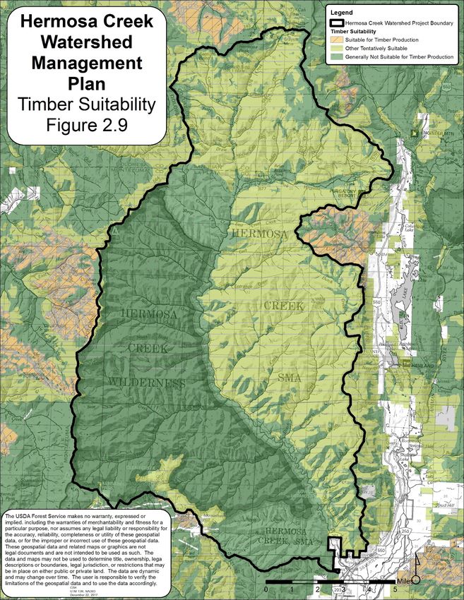
Final San Juan National Forest                                                           March 2021 update
Land and Resource Management Plan

3.1      Tres Rios Field Office Geographic Area
This area is applicable only to BLM lands.

3.2      Dolores Ranger District Geographic Area
The Dolores Ranger District geographic area lies predominantly in Montezuma, Dolores, and San Miguel
Counties, and consists of approximately 597,126 acres of NFS lands. The social center of this geographic
area is the town of Cortez (with a population of approximately 8,500 people). Cortez is the Montezuma
County seat, as well as the commercial center for the smaller communities of Mancos, Dolores, Rico, and
Dove Creek (which is the Dolores County seat), all with populations of 1,200 or less.

The main river systems of this geographic area are the Mancos River (which has headwaters in the La
Plata Mountains) and the Dolores River (which has headwaters in the Lizard Head wilderness). Both
rivers provide irrigation for pastures, hay meadows, and other crops on private lands in the area. McPhee
Reservoir, on the Dolores River, is the second largest body of water in Colorado. It is an important
recreation area, as well as a source of domestic and irrigation water. Use of water from these rivers has
greatly affected both historical settlement patterns and current land uses.

Significant portions of the San Juan Skyway traverse the Dolores geographic area (including U.S.
Highway 145, from Lizard Head Pass down through Rico to Dolores and Cortez, and from there U.S.
Highway 160 to the Montezuma-La Plata County line, which is the boundary with the Columbine
geographic area). Other major segments of the skyway are to the east, in the Columbine geographic
area, and on the Uncompahgre National Forest to the north (going through Ouray, Ridgway, and
Telluride). Since its designation as a scenic byway, the San Juan Skyway has been one of the most
popular recreation attractions in southwest Colorado. It is one of only 26 All-American Roads in the
United States. The skyway’s diverse natural and cultural resources, combined with its unique and
spectacular scenery, give it a claim as one of the crown jewels of scenic byways in the entire nation.
Portions of the Trail of the Ancients Scenic Byway are also located within the Dolores geographic area.

The area includes high densities of significant Puebloan archeological sites (including the Anasazi
Archeological District around McPhee Reservoir), as well as more modern mining, railroad, logging, and
grazing historical sites.

The San Juan Mountains, which are part of the southern Rocky Mountains, fall into the South-Central
Highlands Section. The San Juan Mountains are unusual within the north-south orientation of the Rocky
Mountains, in that they are a large mountain range with an east-west orientation. This part of the
geographic area includes the Lizard Head wilderness and several CRAs (including Storm Peak, Ryman,
Black Hawk Mountain, and portions of San Miguel and Hermosa). This area has much less human
development than the rest of the Dolores geographic area, with most of the development occurring on
private land in the Dolores River valley (including the town of Rico). The area also contains some roads
associated with historic, and current, timber harvesting and historic mining (especially near Rico). Big
game hunting is popular in the fall. Aspen trees are an important component of the vegetation here, both
for their scenic quality and to support the wood product plants in the area.

“The Pine Zone” is located on the west side of the geographic area and was heavily logged in the early
1900s. This area is still being logged; however, the emphasis is now on restoring more natural conditions.
Cattle grazing occurs over most of the area. The area is also popular for big game hunting.

Desired Conditions
3.2.1   Public lands continue to function as “working lands.” Collaborative forest health and rangeland
        management practices reduce wildfire hazards, contribute to the viability of private ranch lands,
        and sustain ecosystem services (including watershed health and wildlife habitat). The local
        economy benefits from, and contributes to, sustainable resource management, as well as the
        preservation of open space.

3.1 Tres Rios Field Office Geographic Area
                                                   152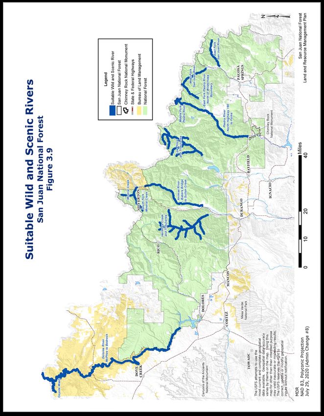
March 2021 update                                                               Final San Juan National Forest
                                                                         Land and Resource Management Plan

3.2.2   The Dolores River system remains a primary water source in order to meet domestic and
        agricultural needs while, at the same time, contributing a wide array of recreational, ecological,
        and aesthetic services. Collaborative efforts support watershed health, instream water quality,
        scenic assets, healthy native and sport fish populations, rafting and flat water boating
        opportunities, and flow and spill management below McPhee Dam in support of ecological,
        recreational, reservoir management, and water rights imperatives.

3.2.3   A variety of looped single- and two-track opportunities for motorized and mechanized recreation
        exist at a range of elevations, offering different levels of difficulty. Motorized and mechanized
        opportunities are balanced with opportunities for foot and horseback access to areas of relative
        quiet and solitude at a variety of elevations. Much of the primary access to these areas is shared,
        based on mutual courtesy and on a strong stewardship ethic that is primarily self-enforced and
        maintained by individuals and user groups.

3.2.4   Cultural and historic resources are protected, interpreted, and promoted through an integrated,
        interagency network involving the BLM’s Anasazi Heritage Center and Canyons of the Ancients
        National Monument, the Ute Mountain Tribal Park, Mesa Verde National Park, and community
        visitor centers (including the Cortez Cultural Center, the Galloping Goose Museum, and the
        Mancos Visitor Center). Residents and visitors are educated and oriented in a manner that
        enhances and encourages their participation in the enjoyment and stewardship of cultural
        resources (which are significant contributors to the local economy).

3.2.5   Scenic vistas are protected and enhanced through collaborative efforts with partners (including
        the Colorado Byways Commission, CPW, the Montezuma Land Conservancy, the Office of
        Community Services, CDOT, Montezuma and Dolores Counties, and the Town of Rico).

3.2.6   The McPhee Reservoir area is one of the Four Corners’ “recreation gems.” A viable marina
        facility is re-established that offers, at a minimum, basic services for those enjoying water sports
        and fishing. A strong connection exists between the reservoir and the town of Dolores.

3.2.7   Ponderosa pine forests on the mesa tops of the Dolores geographic area display structural
        diversity (including more old growth stands, stands with a clumped structure, stands with large old
        trees, snags, and large dead and downed wood on the forest floor).

3.2.8   Narrowleaf cottonwood riparian areas and wetland ecosystem communities throughout the low
        and middle elevations of the Dolores geographic area display moderate to high canopy cover
        (greater than 20%) of narrowleaf cottonwood trees, including young-, middle-, and old-age
        classes.

3.2.9   Willow riparian areas and wetland ecosystem communities throughout the low- and mid-
        elevations of the Dolores geographic area display moderate to high canopy cover (greater than
        20%) of willows, including young-, middle-, and old-age classes.

3.2.10 Aspen management maintains age and class diversity and promotes healthy stand conditions
       while, at the same time, continuing to supply a sustainable supply of aspen products to the local
       and regional industries.

3.2.11 Timber and fire management is used in order to restore stands to an uneven-age condition where
       natural fire regimes and natural processes can occur, and where a multi-aged and multi-cohort
       forest structure resilient to disturbance is established. Timber management in the ponderosa pine
       incorporates restoration forestry into commercial timber sales at an appropriate scale that provide
       support, stabilization, and diversification of the local industry.

See relevant sections in Chapter 3 for specific management direction for the following areas within the
Dolores geographic area:
        •   Wilderness (Lizard Head)
        •   USFS recommended wilderness areas (portions of the Lizard Head and Hermosa CRAs)

                                                                   3.2 Dolores Ranger District Geographic Area
                                                    153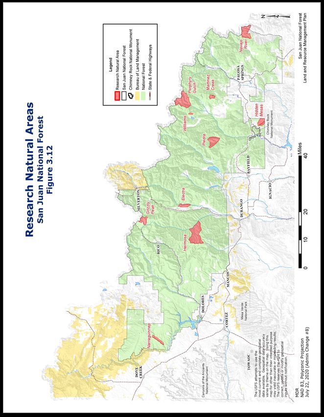
Final San Juan National Forest                                                            March 2021 update
Land and Resource Management Plan

        •   RNAs (Narraguinnep and Grizzly Peak)
        •   Scenic, historic, and backcountry byways (portions of the San Juan Skyway and the
            Trail of the Ancients Scenic Byway)
        •   National recreation and scenic trails (Calico and Highline trails)
        •   Special Areas (Rico and McPhee)

Management Area Composition: Table 3.2.1 shows the distribution of MAs within the Dolores
geographic area.

Table 3.2.1: Management Area Distribution in the Dolores Geographic Area
                     Management Area                            Acres      Percentage of Geographic Area
                                                                                   (USFS lands)
MA 1: natural processes dominate                               34,829                   5.8%
MA 2: special areas and designations                           34,751                   5.8%
MA 3: natural landscapes, with limited management              209,282                 35.1%
MA 4: high-use recreation emphasis                             28,045                   4.7%
MA 5: active management (commodity production in order to      290,090                 48.5%
meet multiple-use goals)
MA 7: public and private lands intermix                           0                    0.0%
MA 8: highly developed areas                                     602                   0.1%
Total                                                          597,599                 100%

3.3     Columbine Ranger District Geographic Area
The Columbine geographic area forms the central part of the planning area. It is situated primarily in La
Plata and San Juan Counties, with some lands in Hinsdale and Archuleta Counties, and consists of
approximately 691,150 acres of NFS lands. The Columbine geographic area shares a northern border
with the Uncompahgre and Rio Grande National Forests, and with the BLM Tres Rios, Uncompahgre,
and Gunnison Field Offices.

The social center of this geographic area is the city of Durango (with a population of approximately
16,000 people). It is the county seat for La Plata County (with a population of approximately 47,000
people). It is also the commercial center for the smaller communities of Bayfield (approximately 1,800
people), Ignacio (approximately 775 people), and Silverton (approximately 600 people; which is the San
Juan County seat). Farmington, Aztec, and Bloomfield (New Mexico) have ties to the area as trade
centers, support for the oil and gas industry, and recreation users (especially of La Plata Canyon).

Durango Mountain Resort (DMR) lies between Silverton and Durango, off of U.S. Highway 550. DMR has
a base area on private land, with some additional base facilities and ski runs permitted on the SJNF. La
Plata and San Juan Counties have approved a Planned Unit Development for the private lands adjacent
to the DMR, with the potential for over 2,000 resort housing and lodging units supported by substantial
commercial development. The likely increase in population adjacent to public lands will result in a need
for close coordination on issues (including trail development, fuels reduction, and wildlife habitat).

Significant portions of San Juan Skyway traverse the Columbine geographic area (including as U.S.
Highway 550 from Durango north to Silverton, and over Red Mountain Pass, which is the boundary with
the Uncompahgre National Forest). A lower elevation portion of the skyway follows U.S. Highway 160
from Mancos Hill to Durango. The other towns in the Columbine geographic area are situated at lower
elevations (and have milder climates). Durango is situated at the intersection of U.S. Highway 550 (which
connects with Silverton to the north, and Aztec and Farmington, New Mexico, to the south) and U.S.
Highway 160 (which connects with Cortez to the west and Pagosa Springs to the east). The city is a hub
for the area. Durango is one of the more mature tourism towns in Colorado, with a historic downtown. It is
supported by tourism related to the Durango-Silverton Narrow Gauge Railroad, the Animas River, DMR,
Mesa Verde National Park, and the Weminuche Wilderness area. Durango is one of a handful of towns
that can make a good claim to the title “mountain bike capital of the world.” Durango is also home to Fort

3.3 Columbine Ranger District Geographic Area
                                                    154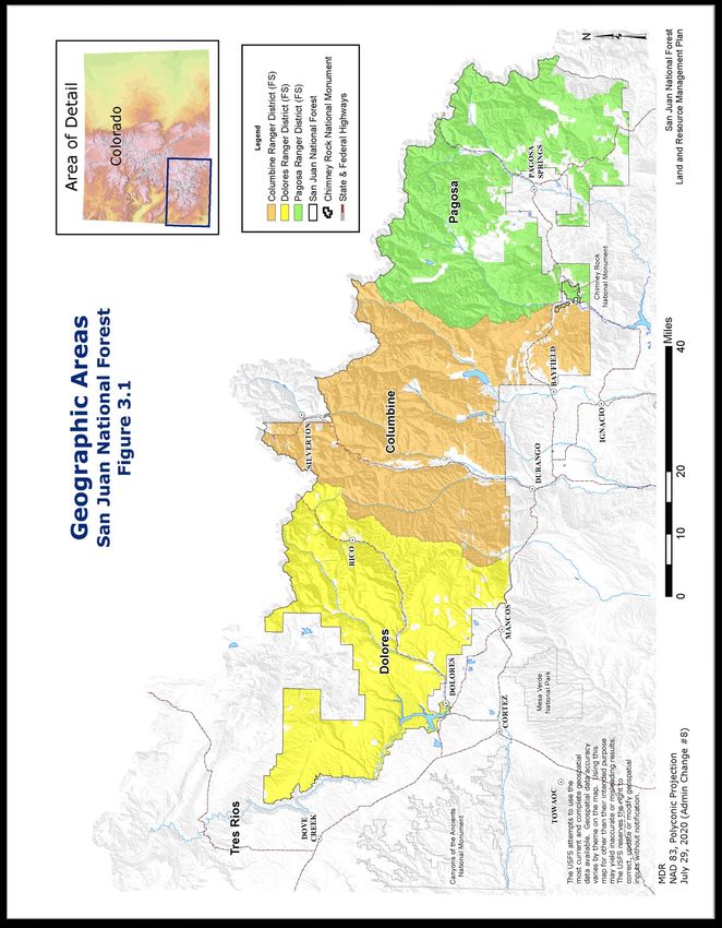
March 2021 update                                                              Final San Juan National Forest
                                                                        Land and Resource Management Plan

Lewis College. It is the governmental, commercial, and entertainment center for southwest Colorado.
Residents of Durango have easy access to public lands within the planning area. Bayfield has been a
bedroom community to Durango but is developing a significant business infrastructure of its own, which is
expected to grow in the coming years.

The main river systems in the Columbine geographic area are the Animas (with headwaters above
Silverton) and the Los Pinos, or Pine (with headwaters in the Weminuche Wilderness). Both rivers drain
into the San Juan River in northern New Mexico, which then joins the Colorado River. Water diversion for
agriculture and municipal use is important on both rivers. Both river systems also contain relatively
pristine stretches that are valued for their scenery and recreational opportunities.

Vallecito Reservoir is in this geographic area; it is the most developed lakeshore resort and recreation
area in southwest Colorado. Above Vallecito Reservoir, and nearby Lemon Reservoir, are access points
to the Weminuche Wilderness. The Los Pinos River flows south from Bayfield through the town of
Ignacio, which is a tri-ethnic community that serves as the headquarters of the Southern Ute Tribe. The
Southern Ute Tribe has combined decades of revenues from energy production with excellent
management in order to become one of the wealthiest tribes in the country.

The higher country, part of the San Juan Mountains, is characterized by steep, rugged terrain with
predominantly spruce-fir, aspen, and mixed conifer forests. Much of the area to the east of U.S. Highway 550
and the Animas River is in either the Weminuche Wilderness or in the Piedra Area (designated in the 1993
Colorado Wilderness Act to be managed to preserve its wilderness character). CRAs include Baldy, Florida
River, Runlett Park, and smaller areas adjacent to the Weminuche Wilderness area and the Piedra Area.

The Missionary Ridge Fire in 2002 burned approximately 73,000 acres in the area north of Durango (east
of U.S. Highway 550), over to the western edge of the Piedra Area (east of Vallecito Reservoir). Early
rehabilitation efforts have gone well; however, restoration would continue to be a concern during the life
of the LRMP. Continued cooperation with local communities (including Vallecito) that were greatly
affected by the fire and its aftermath will continue to be a management goal.

Much of the country west of U.S. Highway 550 is unroaded, including the 37,400-acre Hermosa Creek
Wilderness, and the Hermosa roadless area consisting of about 43,200 acres. This roadless area lies
within the larger 70,600-acre Hermosa Creek Special Management Area, designated by Congress in
2014. The Hermosa Trail, which parallels the main stem of Hermosa Creek, is considered one of the top
mountain bike rides in the country. The eastern portion of the watershed, including the trail, is managed
as MA 2 - Special Areas. The San Miguel area is another large roadless area (a significant portion of
which is to be managed as a MA 1, including Engineer Mountain).

This area is characterized by low- to mid-elevation mountains, mesas, hills, and valleys with mild to
moderate winters and predominantly mixed confer, ponderosa pine, pinyon-juniper, and mountain
grassland vegetation. Coalbed methane reserves exist in large quantities in the northern San Juan Basin
area. Most of this area was leased for oil and gas development prior to the development of this LRMP
with additional development authorized by the Northern San Juan Basin Coalbed Methane EIS (BLM and
USFS 2006) and ROD in 2007 (USFS and BLM 2007). Direction for the area, consistent with that ROD, is
found in Section 3.25 of this LRMP.

The vast amount of undeveloped land that provides a setting for backcountry recreation is a primary
reason people visit this area. Additionally, the area contains some unique access into high-elevation
remote areas (including the Durango-Silverton Narrow Gauge Railroad’s access to Weminuche
Wilderness trailheads, and historic mining roads into the high-elevation mountains around Silverton and in
La Plata Canyon). Compared to the other geographic areas, the Columbine geographic area has the
most trailheads providing access into the backcountry. Given local population, visitors, tourism amenities,
access to the backcountry, and the proximity of other regional destinations, the Columbine geographic
area experiences the greatest amount of recreation users and resulting recreation management
challenges.

                                                                3.3 Columbine Ranger District Geographic Area
                                                    155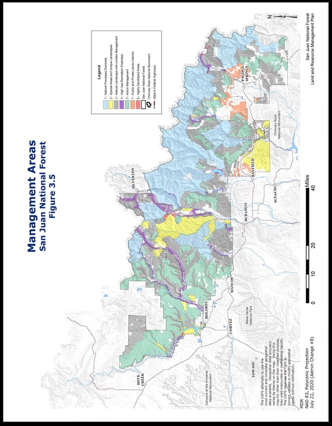
Final San Juan National Forest                                                            March 2021 update
Land and Resource Management Plan

The economies of the communities in the Columbine geographic area have evolved towards an
increasing emphasis on amenity migration (the movement of people for pleasure rather than for economic
reasons), recreation tourism, and resort development, but still have ties to multiple-use management. The
historic connections of La Plata County to ranching, hunting, and public land grazing are of continuing
importance, as the area struggles to protect the scenic, wildlife, and cultural aspects that ranching and
outfitting/guiding play in the overall appeal of the area. Although the historic ties to sawmilling have
substantially diminished, the Missionary Ridge Fire was a reminder of the continued need for forest
management and the economies that help support forest management on public and private lands. The
fact that La Plata County is one of the top energy-producing counties in Colorado also presents multiple-
use management challenges.

Desired Conditions
3.3.1   The full spectrum of outdoor recreational opportunities, ranging from wilderness settings to in-
        town access, is provided. This is the result of a collaborative process for the allocation and
        sharing of uses and stewardship responsibilities designed to protect the quality of the human
        experience and health of the natural environment.

3.3.2   Extensive heritage resources remain central to the area’s economy, culture, and recreational
        experience. Heritage resources, as well as the natural settings that make these resources so
        unique, are protected and sustainable.

3.3.3   Destination and resort development, especially along the river corridors, is planned, developed,
        and managed in order to minimize its impact on the health of surrounding landscapes, natural
        resources, and communities. This is the result of sustained cooperation from the land
        management agencies, interested citizens, state and local agencies, and developers.

3.3.4   Oil and gas development is planned, conducted, and reclaimed to a standard commensurate with
        the ecological, aesthetic, and human values attached to the land where the extraction is
        occurring.

3.3.5   Opportunities for research, particularly applied research, are fully developed with local partners
        (including Fort Lewis College, the Mountain Studies Institute, and the Center for Snow and
        Avalanche Research, as well as other interested groups and institutions).

3.3.6   Winter sports conflicts are reduced through cooperative efforts between motorized and non-
        motorized advocates. Some areas may emphasize one use over another, but many potential
        problems are resolved through agreements on locations of parking areas, grooming, and route
        locations. High-quality opportunities are available for both snowmobiling and backcountry skiing.

3.3.7   The wetlands and fens associated with the upper Pine River and Flint Creek watersheds in the
        Columbine geographic area (where a high density of fens occur) are protected and have the
        water sources and hydrologic systems necessary in order to support and sustain these
        ecosystems.

3.3.8   The wetlands and fens associated with the Lime Creek watershed and the Mountain View Crest
        and Molas Lake areas in the Columbine geographic area (where high concentrations of wetlands
        and potential fens occur) have the water sources and hydrologic systems necessary in order to
        support and sustain these ecosystems.

3.3.9   The Missionary Ridge wildfire area in the Columbine geographic area displays less bare soil and
        erosion, and a higher abundance and distribution of native herbaceous plant species.

3.3.10 The landscapes associated with the intensive gas development in the Columbine geographic
       area display minimal fragmentation. The major vegetation types associated with those lands,
       particularly the ponderosa pine forests, pinyon-juniper woodlands, and mountain shrublands,
       display compositions and structures similar to those that occurred before the development.

3.3 Columbine Ranger District Geographic Area
                                                    156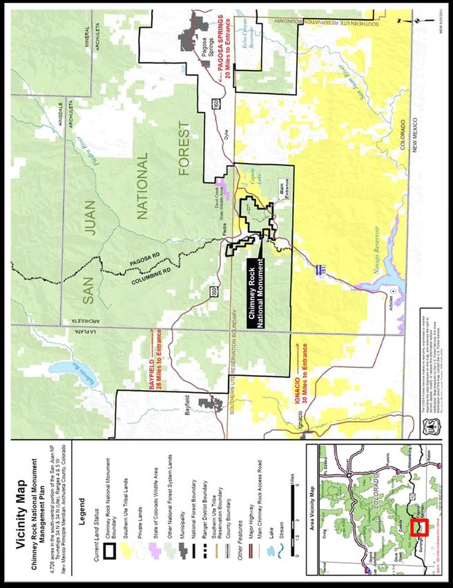
March 2021 update                                                              Final San Juan National Forest
                                                                        Land and Resource Management Plan

See relevant sections in Chapter 3 for specific management direction for the following areas within the
Columbine geographic area:
        •   Wilderness (Weminuche and Hermosa Creek)
        •   USFS recommended wilderness areas (a portion of the Hermosa CRA and the Elk Park
            portion of the Weminuche Adjacent CRA)
        •   Recommended WSR segments (Hermosa Creek and tributaries, Los Pinos and
            tributaries, above Vallecito Reservoir)
        •   RNAs (Electra and Hermosa)
        •   Botanical areas (Chattanooga Iron Fen)
        •   Archeological areas (Falls Creek)
        •   Scenic, historic, and backcountry byways (portions of the San Juan Skyway)
        •   National recreation and scenic trails (portions of the Continental Divide National Scenic
            Trail and the Colorado Trail)
        •   Special Areas (HD Mountains)

Management Area Composition: Table 3.3.1 shows the distribution of MAs within the Columbine
geographic area.

Table 3.3.1: Management Area Distribution in the Columbine Geographic Area
                    Management Area                            Acres       Percentage of Geographic Area
                                                                                   (USFS lands)
MA 1: natural processes dominate                              300,795                  43.7%
MA 2: special areas and designations                          119,204                  17.4%
MA 3: natural landscapes, with limited management             176,106                  25.6%
MA 4: high-use recreation emphasis                            29,258                    4.3%
MA 5: active management (commodity production in order to     51,975                    7.6%
meet multiple-use goals)
MA 7: public and private lands intermix                        7,832                    1.1%
MA 8: highly developed areas                                   2,366                    0.3%
Total                                                         687,536                   100%

3.4     Pagosa Ranger District Geographic Area
The Pagosa geographic area is the easternmost geographic area in the planning area. It is bounded by
the Continental Divide (the boundary with the Rio Grande National Forest) on the north and the east. It is
predominantly situated in Archuleta, Hinsdale, and Mineral Counties, with some lands in Rio Grande and
Conejos Counties. The Pagosa Ranger District consists of approximately 585,770 acres of NFS lands.

The social center of the geographic area is the town of Pagosa Springs (with a population of
approximately 1,620 people). Although Pagosa Springs is the only incorporated town in the geographic
area, much of the population of Archuleta County (with a population of approximately 10,000 people) is in
low-density residential and second-home enclaves, most notably in the Pagosa Lakes area. The
geographic area includes significant acres of Hinsdale and Mineral Counties, but the towns, as well as
almost all of the population of those counties, are situated north of the Continental Divide and the
Weminuche Wilderness area (with little social connection and limited road access to the residents and
businesses in the Pagosa geographic area).

Pagosa Springs sits at the intersection of U.S. Highway 160 (before the road turns north to head over
Wolf Creek Pass) and U.S. Highway 84 (which heads south into northern New Mexico). Pagosa Springs
was historically a compact sawmill and ranching town, with a Hispanic and pioneer Anglo ranching and
sawmilling culture supported by productive forest land and livestock grazing. The area has long-standing
ties with people coming out of Texas and New Mexico in the summer (to where it is cool and green) and
from around the county in the fall (many to hunt big game). Besides the pleasant climate, the area is

                                                                  3.4 Pagosa Ranger District Geographic Area
                                                   157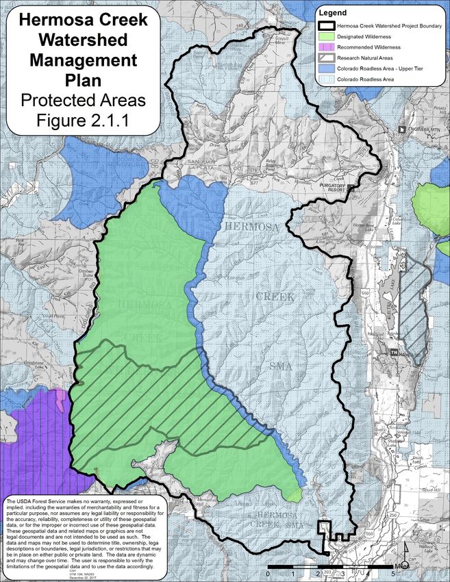
Final San Juan National Forest                                                              March 2021 update
Land and Resource Management Plan

known for outstanding scenery. Many winter visitors to Wolf Creek Ski Area, as well as backcountry skiers
and snowmobilers, stay in Pagosa Springs (rather than in South Fork, which is on the other side of Wolf
Creek Pass).

On a percentage basis, Archuleta County is the fastest growing county in southwest Colorado. Amenity
migration and second-home development began in the 1970s (with the development in the Pagosa Lakes
area west of Pagosa Springs) and now fills most of the triangle of developable land between U.S.
Highway 160, the Piedra Road, and the forest boundary east of Martinez Creek. Similar development has
pushed against the USFS boundary to the west of Pagosa Springs and north of U.S. Highway 160. Much
of the NFS lands around Pagosa Springs are in MA 7 settings (public and private lands intermix), which
reflects this development. In addition to fire risk reduction in these areas, development of trails and
recreation opportunities and the protection of wildlife habitat (especially winter range) are important.

The main river systems in this geographic area are the Piedra River (which has headwaters in the
Weminuche Wilderness area) and the San Juan River (with the headwaters of the West Fork of the San
Juan beginning north of Pagosa Springs in the Weminuche Wilderness area, and the East Fork of the
San Juan beginning northeast of Pagosa Springs in the South San Juan wilderness area). These rivers,
and their tributaries, are important for recreation and scenic quality, as well as for irrigation and domestic
water supplies. They also support a diverse mix of aquatic habitats and riparian and wetland ecosystems
that contribute to the ecologic and economic values of the area.

Approximately 85% of the public lands in the Pagosa geographic area are in the South-Central Highlands
Section (including portions of the Weminuche Wilderness area, the South San Juan wilderness area, and
the Piedra Area). The Treasure Mountain and Turkey Creek CRAs (which lie between the Weminuche
and the South San Juan wilderness areas) contain important linkages and corridors for wildlife
movement. Other IRAs include Graham Peak and areas adjacent to the Weminuche and South San Juan
wilderness areas and the Piedra Area. These areas are managed, for the most part, in order to preserve
their undeveloped character.

At middle and lower elevations in this geographic area, there is an extensive network of roads, primarily
left by historical logging. These roads support many forms of dispersed recreational use and camping,
and are heavily used during hunting season. Restoration-oriented logging is expected in the ponderosa
pine and mixed conifer forest found in this area. This area receives more precipitation than most of the
Southwest and has good growing conditions for timber. Large trees, including aspen, are common.

Having moderate climates, the lower elevation mountains, mesas, and valleys are dominated by
mountain grasslands, and mixed conifer, ponderosa pine, and pinyon-juniper woodlands, where human
settlement has evolved. Much of the human development in the Pagosa geographic area is at the
interface with forest lands, presenting wildfire hazard mitigation challenges that are being actively
addressed through county policy, community wildfire protection planning, and mitigation.

A related challenge is the network of access roads connecting U.S. Highway 160 and U.S. Highway 84 to
the SJNF. These roads provide access to residential subdivisions and other private in-holdings. They also
provide recreation access to public lands for local visitors, as well as for visitors from out of the area. The
pressure on these roads presents maintenance demands and costs that must be worked out
collaboratively among local, state, and other federal agencies; property owners; and public land users.
Growth in the Pagosa geographic area has reached a point where more domestic water and water
storage are needed in order to meet increasing demand. This requires continued cooperation, in terms of
exploring alternatives that involve storage and/or diversion facilities located on federal lands (where
protecting the ecological integrity of affected stream channels is mandated).

The Pagosa geographic area’s most striking heritage resource is the Chimney Rock National Monument.
The user-supported interpretive tours, special events, and visitor center at this unique pre-Puebloan site
are conducted and staffed by a very active group of volunteer citizens.

3.4 Pagosa Ranger District Geographic Area
                                                     158
March 2021 update Final San Juan National Forest
Land and Resource Management Plan
Desired Conditions
3.4.1 Management activities maintain or enhance the ecological sustainability and integrity of the area.
The demands of residents and users are balanced with the protection of watersheds, wildlife
habitat, vegetation, soil productivity, and undisturbed natural areas.
3.4.2 The Pagosa geographic area is a destination for hunters, hikers, and motor vehicle enthusiasts. It
promotes partnerships and responsible stewardship in all recreational uses of the public lands.
3.4.3 The local economy is supported and diversified by agency activities and programs (including
maintaining roads, facilities, and campgrounds; supporting stewardship and partnerships; and
providing a wide spectrum of recreation and tourism opportunities).
3.4.4 The USFS recognizes the needs of the area’s growing population of residents and visitors. SJNF
facilities (including roads, bridges, campgrounds, and trailheads) are designed and maintained to
the proper standards for safe and efficient access to public lands.
3.4.5 The SJNF actively cooperates with local governments, residents, and land users in order to
maintain and enhance the safety and enjoyment of the public lands. This is accomplished through
the protection of scenery, the mitigation of WUI fire danger, and land ownership adjustments.
3.4.6 White fir is less abundant in the warm-dry and cool-moist mixed conifer forests of the Pagosa
geographic area. The rare bristlecone pine forests that only occur in the Pagosa geographic area
are protected and sustainable.
Please see relevant sections in Chapter 3 for specific management direction for the following areas within
the Pagosa geographic area:
• Wilderness (Weminuche and South San Juan)
• Other Congressional designations (Piedra Area)
• USFS recommended wilderness areas (portions of the Turkey Creek, Monk Rock, and
Weminuche Adjacent CRAs)
• Recommended WSR segments (the Piedra River, from U.S. Highway 160 to the Forks;
East Fork of the Piedra, north of the wilderness boundary; Middle Fork of the Piedra;
and West and East Fork of the San Juan River)
• Chimney Rock National Monument
• RNAs (Williams Creek, Martinez Creek, Hidden Mesas, Navajo River, Piedra, Porpyry
Gulch)
• Botanical areas (O’Neal Hill, site of the globally rare Pagosa Springs bladderpod
[Lesquerella pruinosa]).
• National recreation and scenic trails (portions of the Continental Divide National Scenic
Trail).
Management Area Composition: Table 3.4.1 shows the distribution of MAs within the Pagosa
geographic area.
Table 3.4.1: Management Area Distribution in the Pagosa Geographic Area
Management Area Acres Percentage of Geographic Area
(USFS lands)
MA 1: natural processes dominate 252,306 43.4%
MA 2: special areas and designations 9,089 1.5%
MA 3: natural landscapes, with limited management 169,612 29.2%
MA 4: high-use recreation emphasis 8,623 1.5%
MA 5: active management (commodity production in order to 100,611 17.3%
meet multiple-use goals)
MA 7: public and private lands intermix 40,605 7.0%
MA 8: highly developed areas 824 0.1%
Total 581,670 100%
3.4 Pagosa Ranger District Geographic Area
159Final San Juan National Forest March 2021 update
Land and Resource Management Plan
3.5 Management Areas
MA designations apply to all SJNF lands within the planning area. MAs describe the intensity of
management that can be expected within each MA, ranging from areas where natural processes
dominate and shape the landscape to areas that are intensely managed. In addition to the level of
management, MAs also provide a general sense of how the landscape will appear and identify uses and
activities that are allowed. To varying degrees, multiple uses occur within all the MAs. The allowable use
tables for each MA portray the suitability determinations made under the grazing, timber, and travel
programs in Chapter 2 as they apply to each MA, and also identify additional uses that are listed as
allowable, restricted, or prohibited (if there are discrepancies between allowable use tables and grazing,
timber, or travel suitability maps, the suitability map takes precedence). Table 3.5.1 identifies the
distribution of MAs across the SJNF (see also Figure 3.5).
Table 3.5.1 Management Area Allocations on San Juan National Forest Lands
Management Area Acres Percent of
SJNF
MA 1 Natural Processes Dominate 587,930 31.5%
MA 2 Special Areas and Designations 163,044 8.7%
MA 3 Natural Landscapes, with Limited Management 555,000 29.7%
MA 4 High-Use Recreation Emphasis 65,926 3.6%
MA 5 Active Management (commodity production in order to 442,676 23.7%
meet multiple-use goals)
MA 7 Public and Private Lands Intermix 48,437 2.6%
MA 8 Highly Developed Areas 3,791 0.2%
Total 1,866,804 100%
Some exceptions may apply to activities, particularly those activities that are pursuant to reserved or
outstanding rights, or as provided by statute or treaty. Additionally, there are 529,700 acres of CRAs on
the SJNF. CRAs are governed by the Colorado Roadless Rule and may have additional restrictions
beyond the general suitability identified by MAs. When guidance in a forest plan is more restrictive than
direction described in the Colorado Roadless Rule, actions must be consistent with the more restrictive
direction.
3.5 Management Areas
160March 2021 update Final San Juan National Forest
Land and Resource Management Plan
Figure 3.5: Management Areas, San Juan National Forest
3.5 Management Areas
161Final San Juan National Forest March 2021 update
Land and Resource Management Plan
Management Area 1 (MA 1): Natural Processes Dominate
These relatively pristine lands are places where natural ecological processes operate free from human
influences. Succession, fire, insects, disease, floods, and other natural processes and disturbance events
shape the composition, structure, and landscape patterns of the vegetation. These areas contribute
significantly to ecosystem and species diversity and sustainability, serve as habitat for fauna and flora,
and offer wildlife corridors, reference areas, primitive recreation opportunities, and places for people
seeking natural scenery and solitude. Roads and human structures are absent and management
activities are limited on MA 1 lands. Motorized travel, and in most cases, motorized equipment are
prohibited. MA 1 areas include designated wilderness areas, the Piedra Area, WSAs, and other lands
where a primary desired condition is to maintain the undeveloped natural character of the landscape.
See Table 3.5.2 for a list of allowable, restricted, and prohibited uses within MA 1.
Table 3.5.2: Management Area 1 Allowable Uses
Activities and Uses Allowable - Restricted - Prohibited
Fire managed for resource benefit Allowable
Prescribed burning Allowable
Mechanical fuels treatment Restricted (allowable when meeting desired conditions of the
area)
Timber production (scheduled on a rotation basis) Prohibited
Timber harvesting as a tool Prohibited
Commercial use of special forest products and Prohibited
firewood
Land use ROWs, special use permits, and utility Prohibited
corridors
Livestock grazing Allowable
Facilities Prohibited
Motorized (summer) Prohibited
Motorized (winter) Prohibited
Non-motorized (summer and winter) Allowable
Mechanical transport Restricted (mountain bikes are allowable in MA 1 landscapes
outside designated wilderness)
Road construction (permanent or temporary) Prohibited
Minerals - leasable (oil and gas, and other) Restricted (designated wilderness, WSAs, and the Piedra
Area are withdrawn from mineral leasing; a NSO stipulation
would be applied to CRAs outside designated wilderness)
Minerals - locatable Prohibited (wilderness areas are withdrawn from locatable
mineral entry, subject to valid and existing rights; other MA
1 areas are open to mineral entry, but impacts to natural
resource must be minimized; the agency can petition for the
area to be withdrawn from mineral entry)
Minerals - saleable (materials) Prohibited
Management Area 2 (MA 2): Special Areas and Designations
These areas possess one or more special feature or characteristic that makes them, and their
management, unique from other areas within the planning area. MA 2 areas include RNAs, archeological
areas, habitat areas, botanical areas, and other unique areas that have a mix of special features and
uses. In general, MA 2 areas are managed in order to protect or enhance their unique characteristics;
therefore, management intensity and suitability varies by each area. See subsequent sections in Chapter
3 of this LRMP for specific management direction for these MA 2 areas.
3.5 Management Areas
162March 2021 update Final San Juan National Forest
Land and Resource Management Plan
Management Area 3 (MA 3): Natural Landscapes with Limited Management
MA 3 lands are relatively unaltered places where natural ecological processes operate primarily free from
human influences. Succession, fire, insects, disease, floods, and other natural processes and disturbance
events predominantly shape the composition, structure, and landscape patterns of the vegetation. These
areas contribute to ecosystem and species diversity and sustainability, serve as habitat for fauna and
flora, and offer wildlife corridors, reference areas, primitive and semi-primitive recreation opportunities,
and places for people seeking natural scenery and solitude.
On the SJNF, approximately 62% of the MA 3 lands are within CRAs. Management activities are allowed
in MA 3 areas but are more limited in the CRAs. For MA 3 lands that are not CRAs, roads, infrastructure,
and management activities are more common. Management activities include habitat and ecosystem
restoration, livestock grazing, wildland fire and prescribed burning, hazardous fuels reduction, salvage
logging following fire, insect epidemics and/or wind events, and invasive species treatments. Motorized
equipment may be used, and temporary road construction is allowed; however, most roads would be
closed upon project completion. Most MA 3 areas emphasize non-motorized recreation opportunities, but
motorized travel occurs in some areas on existing roads and motorized trails. Most MA 3 lands are
available for fluid mineral leasing with specific resource stipulations; however, surface occupancy and
road construction is prohibited (i.e., NSO stipulation) in CRAs. See Table 3.5.3 for a list of allowable,
restricted, and prohibited uses within MA 3.
Table 3.5.3: Management Area 3 Allowable Uses
Activities and Uses Allowable - Restricted - Prohibited
Fire managed for resource benefit Allowable
Prescribed burning Allowable
Mechanical fuels treatment Allowable
Timber production (scheduled on a rotation basis) Prohibited
Timber harvesting as a tool Allowable
Commercial use of special forest products and Allowable
firewood
Land use ROWs, special use permits, and utility Restricted (development may be conditioned or prohibited in
corridors CRAs and lands managed for wilderness characteristics)
Livestock grazing Allowable
Facilities Restricted (development may be prohibited in CRAs and
lands managed for wilderness characteristics)
Motorized (summer) Restricted (motorized travel may occur in some MA 3
locations on designated routes)
Motorized (winter) Restricted (oversnow motorized travel may occur in some
MA 3 locations)
Non-motorized (summer and winter) Allowable
Mechanical transport Allowable
Road construction (permanent or temporary) Restricted (temporary road construction may occur in some
MA 3 locations in order to achieve resource desired
conditions; exceptions may apply for valid existing rights;
additional road construction would also be allowed subject to
valid existing rights and terms of development authorization)
Minerals - leasable (oil and gas, and other) Restricted (special lease stipulations [i.e., NSO, CSU, TL]
may apply to specific resources within MA 3 areas)
Minerals - locatable Allowable (open to mineral entry per the 1872 Mining Law;
however, the exploration and development of mining claims
may be subject to restrictions to protect resources)
Minerals - saleable (materials) Restricted (limited road access and other constraints in MA 3
landscapes may limit or preclude mineral collection.)
3.5 Management Areas
163Final San Juan National Forest March 2021 update
Land and Resource Management Plan
Management Area 4 (MA 4): High-Use Recreation Emphasis
These areas are places with relatively high levels of recreation use that is managed in order to provide a
wide variety of opportunities and experiences to a broad spectrum of visitors. They are associated with, and
often provide, access to popular destinations, transportation corridors, scenic byways, scenic vistas, lakes,
and streams. Developed recreation facilities that provide user comfort and resource protection are present.
These areas tend to be altered by human activities, but also include some more undeveloped places
(including backcountry travel corridors). Visitors can expect to see a wide range of human activities and
development (including roads, trails, interpretive sites, campgrounds, trailheads, fences, and day-use
facilities). Both motorized and non-motorized activity is common. Natural ecological processes and
disturbance agents (including succession and fire) are often influenced by humans on most of these lands.
Resource uses (including livestock grazing, timber management, and wildlife management) may occur in
conjunction with surrounding recreation and scenic objectives. Mineral development, mining, and alternative
energy infrastructure is generally not compatible within MA 4 areas, e.g., in developed recreation sites or
along scenic corridors. See Table 3.5.4 for a list of allowable, restricted, and prohibited uses within MA 4.
Table 3.5.4: Management Area 4 Allowable Uses
Activities and Uses Allowable - Restricted - Prohibited
Fire managed for resource benefit Restricted (may be used in order to meet desired conditions
on adjacent lands)
Prescribed burning Allowable
Mechanical fuels treatment Allowable
Timber production (scheduled on a rotation basis) Prohibited
Timber harvesting as a tool Allowable
Commercial use of special forest products and Restricted (restrictions may apply within developed
firewood recreation areas)
Land use ROWs, special use permits, and utility Allowable
corridors
Livestock grazing Restricted (restrictions may apply within developed
recreation areas)
Facilities Allowable
Motorized (summer) Allowable
Motorized (winter) Allowable
Non-motorized (summer and winter) Allowable
Mechanical transport Allowable
Road construction (permanent or temporary) Allowable
Minerals - leasable (oil and gas, and other) Restricted (special lease stipulations [i.e., NSO, CSU, TL]
may apply to specific resources within MA 4 areas)
Minerals - locatable Allowable (open to mineral entry per the 1872 Mining Law;
however, the exploration and development of mining claims
may be subject to restrictions to protect resources)
Minerals - saleable (materials) Restricted (generally not compatible within developed
recreation areas or scenic corridors)
3.5 Management Areas
164March 2021 update Final San Juan National Forest
Land and Resource Management Plan
Management Area 5 (MA 5): Active Management
These multiple-use areas are places where active management occurs in order to meet a variety of social,
economic, and ecological objectives. They are easily accessible, occurring mostly on roaded landscapes
and relatively gentle terrain. These are lands where timber harvesting, oil and gas activities, and intensive
livestock grazing occur and influence the composition, structure, and landscape patterns of the vegetation.
Natural ecological processes and disturbance agents (including succession and fire) are often influenced by
humans on many of these lands. A mosaic of vegetation conditions is often present, some showing the
effects (impacts) of past management activities, others appearing predominantly natural. These areas
contribute to ecosystem and species diversity and serve as habitat for fauna and flora.
In MA 5 areas, visitors can expect to see a wide range of human activities, development, and
management investments (including roads, trails, fences, corrals, stock ponds, timber harvesting
equipment, oil and gas wells, and livestock). Maintenance of past and current investments is anticipated
to be continued for future management opportunities. Motorized and non-motorized recreation
opportunities are easily accessed by the relatively dense network of roads found on these lands. Hiking
trails provide access for visitors (who can expect contact with others). Developed recreation facilities that
provide user comfort and resource protection are present. See Table 3.5.5 for a list of allowable,
restricted, and prohibited uses within MA 5.
Table 3.5.5: Management Area 5 Allowable Uses
Activities and Uses Allowable - Restricted - Prohibited
Fire managed for resource benefit Allowable
Prescribed burning Allowable
Mechanical fuels treatment Allowable
Timber production (scheduled on a rotation Allowable
basis)
Timber harvesting as a tool Allowable
Commercial use of special forest products and Allowable
firewood
Land use ROWs, special use permits, and utility Allowable
corridors
Livestock grazing Allowable
Facilities Allowable
Motorized (summer) Allowable
Motorized (winter) Allowable
Non-motorized (summer and winter) Allowable
Mechanical transport Allowable
Road construction (permanent or temporary) Allowable
Minerals - leasable (oil and gas, and other) Allowable (special lease stipulations [i.e., NSO, CSU, TL)]
may apply to specific resources within MA 5 areas)
Minerals - locatable Allowable (open to mineral entry per the 1872 Mining Law;
however, the exploration and development of mining claims
may be subject to restrictions to protect resources)
Minerals - saleable (materials) Allowable
3.5 Management Areas
165Final San Juan National Forest March 2021 update
Land and Resource Management Plan
Management Area 7 (MA 7): Public and Private Lands Intermix
These areas are places where the public lands within the planning area are in close proximity to private
lands; therefore, coordination with communities and local governments is essential in order to balance the
needs of both parties. MA 7 areas are often associated with towns and cities, as well as with the houses,
structures, people, and values associated with them. Visitors can expect to see a wide range of human
activities and development (including roads, trails, fences, signs). In some MA 7 areas, oil and gas
development is evident.
The proximity of these areas to private lands makes them a priority for fuels and vegetation treatments in
order to reduce wildfire hazards. The backyard or rural recreation setting provided by many of these lands
is an amenity to the active lifestyles and quality of life for local residents. Hiking, biking, and dog-walking
are common activities. These areas contribute to ecosystem and species diversity, and serve as habitat
for fauna and flora. Winter range for deer and elk is a common component of MA 7 areas, as are
seasonal closures in order to reduce animal disturbance. Natural ecological processes and disturbance
agents (including succession and fire) are influenced by humans on most of these lands.
Land exchanges, acquisitions, and disposals can be undertaken in order to improve the intermingled land
ownership patterns that are common in MA 7 areas. Cooperation with adjacent landowners and local
governments is common in order to improve access and convey roads to county jurisdictions, where
appropriate. Cooperation is also be important in order to improve the transportation network, enhance
protect resources, and allow authorized legitimate access to public lands. Utility and communication
distribution lines tend to be more common in these areas. See Table 3.5.6 for a list of allowable,
restricted, and prohibited uses within MA 7.
Table 3.5.6: Management Area 7 Allowable Uses
Activities and Uses Allowable - Restricted - Prohibited
Fire managed for resource benefit Prohibited
Prescribed burning Allowable
Mechanical fuels treatment Allowable
Timber production (scheduled on a rotation basis) Prohibited
Timber harvesting as a tool Allowable
Commercial use of special forest products and Allowable
firewood
Land use ROWs, special use permits, and utility Allowable
corridors
Livestock grazing Allowable
Facilities Allowable
Motorized (summer) Allowable
Motorized (winter) Allowable
Non-motorized (summer and winter) Allowable
Mechanical transport Allowable
Road construction (permanent or temporary) Allowable
Minerals - leasable (oil and gas, and other) Allowable (special lease stipulations [i.e., NSO, CSU, TL]
may apply to specific resources within MA 7 areas)
Minerals - locatable Allowable (open to mineral entry per the 1872 Mining Law;
however, the exploration and development of mining claims
may be subject to restrictions to protect resources)
Minerals - saleable (materials) Allowable (depending on location and resources present,
resource restrictions may apply as identified in the LRMP
standards and guidelines)
3.5 Management Areas
166You can also read