City of Troy - Comprehensive Plan 2012 - MISSOURI
←
→
Page content transcription
If your browser does not render page correctly, please read the page content below
Comprehensive Plan 2012

      C      ity of
      T        roy
                 MISSOURI

      ~ Adopted January 2012 ~
Comprehensive Plan 2012

                Troy Planning and Zoning Commission Members
                              Jim Zuroweste (Chair)
                                 DeeAnn Aydelott
                                    Kevin Bishop
                                   Patsy Creech
                                   Dennis Dunn
                                 Gerard Hagedorn
                                  Barb Heimann
                                Charles Twellmann
                                     Vicki Kuhl
                                  Jim Zuroweste

                           Troy Board of Alderman
                                     WARD 1
                                    Janet Bass
                                   Ron Sconce

                                     WARD 2
                                  Lisa Anderson
                               Margaret Eversmeyer

                                    WARD 3
                                 Dennis Detert
                                Gerard Hagedorn

                                 Mayor of Troy
                                   Mark Cross

                             Assisting Consultants
                      Boonslick Regional Planning Commission
                           111 Steinhagen PO Box 429
                              Warrenton, MO 63383

                                        i
Comprehensive Plan 2012

Introduction (1)
Why Plan?    (2)
Methodology (3)

I. EXECUTIVE SUMMARY (4)

II. COMMUNITY VISION AND GOALS (5)
      A Vision for the Future (5)
      Community Goals         (5)

III. RELEVANT REGIONAL PLANS & STUDIES (7)

IV. A HISTORICAL SNAPSHOT OF TROY (11)
       Troy and the East Central Missouri Region (14)
       Demographics and Socio‐Economic Indicators (14)
       Summary Trends and Implications (17)

V. COMPREHENSIVE PLAN ELEMENTS (19)
1. PEOPLE, NEIGHBORHOODS AND HOUSING (19)
      People and Population (19)
      Housing and Neighborhoods (23)
      Challenges and Opportunities (27)
      Guiding Policies and Actions (28)

2. EDUCATION AND HEALTH (30)
      Schools (30)
      Higher Education (32)
      Libraries (32)
      Health Care Facilities (32)
      Social Services (32)
      Challenges and Opportunities (34)
      Guiding Policies and Actions (35)

3. ECONOMIC DEVELOPMENT (36)
      Employment and Industry (36)
      Downtown (37)
      Entrance Corridors (38)
      Tourism (38)
      Other Events (38)
      Challenges and Opportunities (40)
      Guiding Policies and Actions (41)

                                                  ii
Comprehensive Plan 2012

4. PARKS, OPEN SPACE AND RECREATION (43)
      Area Parks and Community Facilities (43)
      Cuivre River State Park (44)
      Challenges and Opportunities (46)
      Guiding Policies and Actions (47)

5. TRANSPORTATION (48)
      Streets and Multi‐modal Systems (48)
      Current Projects (51)
      Prioritization Process (51)
      Challenges and Opportunities (52)
      Guiding Policies and Actions (53)

6. PUBLIC SERVICES AND INFRASTRUCTURE (54)
      Public Safety (54)
      Water and Sewer (55)
      Broadband/Communications (60)
      Challenges and Opportunities (61)
      Guiding Policies and Actions (62)

7. ENVIRONMENT (63)
      Climate (63)
      Hydrology: Streams and Floodplains (63)
      Topology and Geology (63)
      Challenges and Opportunities (66)
      Guiding Policies and Actions (67)

8. LAND USE AND BUILT FORM (68)
      Existing Land Use (68)
      Future Land Use and Growth Management (72)
      Design Guidelines for Rehabilitation and New Development (73)
      Guiding Policies and Actions (76)

VI. PLAN IMPLEMENTATION MATRIX (77)
       Implementation Matrix (78)

VII. CONCLUSION (89)

                                                  iii
Comprehensive Plan 2012

List of Chart and Graphs

4.1 – Unemployment Rate (16)
4.2 – Employment by Industry (17)
5.1 – City of Troy Population (19)
5.2 – Troy Population Projections (22)
5.3 – Troy Water Storage (55)
5.4 – Troy Water Production (56)
5.5 – Troy Wastewater Capacity (58)

List of Maps

Map 1 – Housing Infrastructure (24)
Map 2 – Vacant Lots (26)
Map 3 – Schools, Government Buildings, & Organizations (31)
Map 4 – Health & Human Services (33)
Map 5 – Parks & Recreation (45)
Map 6 – Waste Water Distribution (57)
Map 7 – Water Distribution (59)
Map 8 – Flood Zones (65)
Map 9 – Existing Land Use (70)
Map 10 – Current Zoning (71)

                                                iv
Comprehensive Plan 2012

List of Tables

4.1 – Total Population (14)
4.2 – Population Projections (14)
4.3 – Median Household Income (15)
4.4 – Annual Weekly Wage & All Industries (15)
5.1 – Demographic Snapshot (20)
5.2.1 – Population Change {% change} (21)
5.2.2 – Population Change {# change} (21)
5.3 – Housing Snapshot (25)
5.4 – Top Ten Employers in Lincoln County, Missouri (36)
5.5 – Park Size & Classification (44)
5.6 – Troy Wastewater Capacity (58)

                                                 v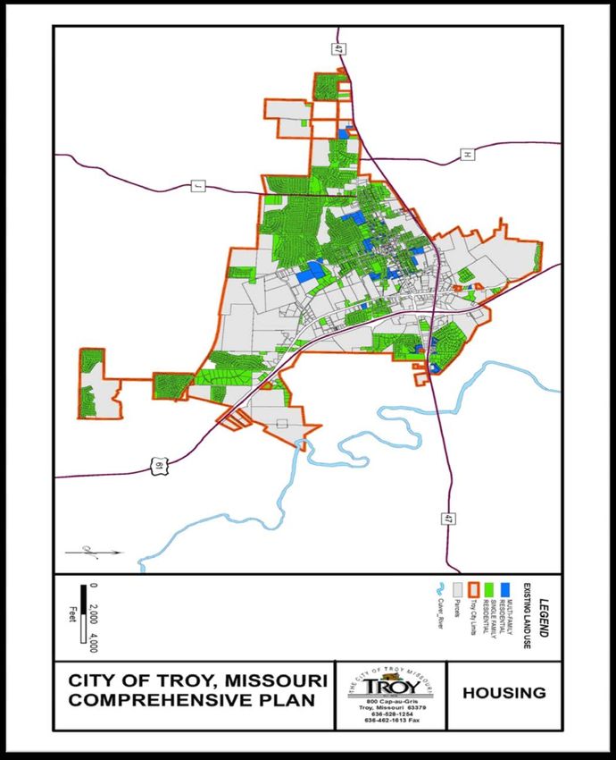
Comprehensive Plan 2012

INTRODUCTION

A comprehensive plan is a public document that
serves as a community guide for the future.
Comprehensive plans look at a range of existing
conditions within the community and make general
recommendations for the future, planning for about a
20‐year time horizon. The comprehensive plan is
developed with input from citizens and guidance from
the planning commission, and is ultimately adopted by
the City Council. Thereafter, it provides a framework
for important decisions in the community such as
where growth should occur, how land should be used
and where spending priorities should be placed for
the next ten to twenty years. Comprehensive plans are general in nature but provide the legal basis for
key land management tools like zoning and subdivision regulations. At a minimum, comprehensive plans
must address land use, community facilities, public services, housing, environmental features and
transportation.

This Comprehensive Plan for Troy takes a fresh look at the community and brings together the
feedback of citizens, civic groups and local officials to provide a long‐term view to guide local
decision‐making. The Plan is organized in six main sections for ease of reference. Following this
introduction is an Executive Summary that highlights the main points in the Plan. This is followed by a
descriptive vision for the future of Troy and a summary of overarching goals that are common threads
within all of the Plan elements. Next is a snapshot of past planning efforts and accomplishments,
followed by a brief history of community development. Section IV offers a visual and statistical snapshot
of how Troy relates to the broader region.

The bulk of the Comprehensive Plan is found in Section V; it contains key data and analysis of existing
conditions and current issues and an elaboration of various policies, strategies and action items for the
city. This Plan ends with a summary roadmap for implementing recommendations and key action
projects, identifying important partners and resources involved in each effort.

                                                                                                            1
Comprehensive Plan 2012

WHY PLAN?

The Troy Planning & Zoning Commission was established with the following purpose and regulations:

  “The purpose of Planning and Zoning is to regulate and control the zoning and use of land
  within the City of Troy through the establishment of zoning districts in order to promote the
                public safety, health and general welfare of the citizens of Troy.”

The regulations are designed to:
   1. Protect character and stability;
   2. Promote the orderly development of the different classes of land uses (e.g. residential, commercial,
       industrial, open space);
   3. Regulate the intensity of land use development; provide for open space and landscaping in the
       development process;
   4. Establish standards for land development and the construction of buildings and structures;
   5. Prohibit uses, buildings and structures which are incompatible with the existing or desired character of
       development;
   6. Prevent illegal additions or alterations of existing buildings and structures;
   7. Preserve and enhance the value of property throughout the city.

                                                                                                                 2
Comprehensive Plan 2012

METHODOLOGY

Various methods and databases were used to prepare this plan. The most prominently used database
was the U.S. Census Bureau’s, which was used to better understand variables such as population,
socioeconomic status, employment, and mobility. Additional data from the Missouri Census Data
Center, MoDOT, the Lincoln County Assessor’s Office, and data from the Office of Social and
Economic Data Analysis was also used. The majority of the data was analyzed through comparisons
between the City of Troy, Lincoln County, the surrounding counties of Pike, Warren, Montgomery, St.
Charles, and the State of Missouri as a whole.

Several entities helped contribute to the final construction of the plan. The Boonslick Regional Planning
Commission (BRPC) was responsible for the compilation and format of the document itself. Narratives
within this document can be attributed to outcomes generated through meetings conducted by the
Comprehensive Plan Task Force, survey output, the analysis of statistics gathered by BRPC, as well as
general discussion with local government officials and residents of the City of Troy.

One survey was conducted as a part of this study. The survey [Appendix A] was administered through a
third party site called Zoomerang. The survey was made public to those individuals who attended the
first public meeting held in the City of Troy. In total, more than 66 surveys were collected. More than
half of residents surveyed live within the city limits of Troy, while approximately 44% live outside the
city limits.

                                                                                                            3
Comprehensive Plan 2012

I. EXECUTIVE SUMMARY

Troy’s Comprehensive Plan provides a long‐term vision and incorporates recommendations for the
city’s future from city staff, local officials, residents and businesses. The Plan also serves as a guide for
land management and decision‐making. This Plan is not required by any code or statute in the State of
Missouri. Nevertheless, this plan will require monitoring and review to ensure the Plan continues to
meet the needs and represent the vision of the evolving community.

Several major themes carry through this plan, including:
    •   Expanding diversity and balance of the local economy and promoting links to education, arts,
        history and tourism.
    •   Restoring and maintaining neighborhood vitality through appropriate development, housing
        diversity and context‐sensitive infill.
    •   Coordinating with local and regional plans and agencies.
    •   Enhancing the quality of life for residents, workers, visitors and businesses through expanded
        educational, cultural and recreational offerings.

Some of the significant initiatives should include:
    •   Continued downtown revitalization through appropriate infill development, development of
        housing opportunities, expansion of existing facilities and efforts to attract key businesses and
        services, particularly those related to the arts.
    •   Efforts to diversify housing types and price ranges.
    •   Reviewing and strengthening of land use regulations for areas of historical or ecological
        significance.
    •   Establishment of development guidelines for key commercial corridors leading into the
        community.
    •   Expansion of cultural and artistic offerings and improved coordination among local and regional
        efforts and marketing.

                                                                                                                4
Comprehensive Plan 2012
II. COMMUNITY VISION & GOALS
A Vision for the Future
The community of Troy has a proud history dating to the days of our County’s westward expansion.
Troy is a community whose citizens are engaged and united in their desire to see the city prosper and
maintain its unique identity in the East Central Missouri region.
The Vision below has been developed based on comments received from public work sessions. It serves
as a common direction for long‐term planning in Troy:
“We envision Troy as a complete community of quality amenities and city services,
with a deep sense of community spirit and pride of appearance. We envision Troy
as a growing city that balances preservation of its historic past with the best of
modern living.”
Community Goals
During public workshops and Task Force meetings with city citizens and leaders, key themes emerged as
goals for the future of Troy. Those goals (related particularly to community environmental resources,
historic and cultural resources, housing, transportation, and economic development) are relevant to all
aspects of the plan and help shape the vision above.
History and Culture
Troy will be a community whose full history is preserved and told to newcomers and residents alike in
its restored and protected historical structures and its diverse range of local festivals and other heritage
tourism efforts.
Economic Development
Troy will be a prominent economic driver for the region, with a diverse economy that balances the
retail, industrial, agricultural and service sectors. Local educational opportunities will be closely linked
with industry and business needs. The city will be attractive to entrepreneurs, foster homegrown
business development and retain local talent, create jobs, encourage private investment and increase
wages.
Housing
Troy will maintain high quality construction standards for new housing development through adoption,
review, and enforcement of codes and ordinances. The city shall protect the aesthetic value of all
housing stock and neighborhoods, while committing to increasing housing choice and diversity.
5Comprehensive Plan 2012
Environment
Troy shall celebrate its natural heritage with innovative measures aimed at protecting the surrounding
farmland and identifying future park spaces and by adopting green technologies and practices in its public
operations and promoting them among private enterprises and individual citizens. Sustainable techniques
will be incorporated into future designs.
Transportation
The city will invest in improving the condition of streets in older sections of the city, while focusing
more on improving pedestrian facilities and options for alternate transportation in the city, such as
sidewalk requirements for new development and redevelopments. Troy will also continue to improve
access to schools, to mitigate overall congestion and improve safety for students and pedestrians alike.
Infrastructure
An adequate water supply and distribution system shall meet the needs of current and anticipated
customers. Troy shall maintain a competitive rate structure with the surrounding areas, while
maintaining compliance with current and anticipated future regulations.
Public Services
The City of Troy will pursue a farmers market to be located within the city limits; as Troy residents
have successfully supported adjacent markets in Silex and Moscow Mills. Troy health care industries will
continue to expand and city officials will seek to identify future locations for expansion, as well as
business recruitment within the sector. Community services, such as the Powell Memorial library and
neighborhood parks and trails, shall be enhanced for future generations. Current and future public
transit options will be identified and improved upon.
These overarching long‐term goals are important to all portions of the comprehensive plan. These goals
are further detailed in the policy and action strategies within each section of the plan, and are
summarized in a user‐friendly implementation matrix at the end of the plan.
6Comprehensive Plan 2012
III. RELEVANT REGIONAL PLANS & STUDIES
Several studies and plans provide direction and establish a number of goals in key areas that impact Troy
planning efforts.
Lincoln County Economic Development Strategy
The Lincoln County Economic Development Strategy, prepared in 2010 by the Boonslick Regional
Planning Commission, was created to guide the region’s economic growth by fostering a more stable
and diverse economy, assisting in the creation of jobs, and improving the overall living conditions in the
County. Noted in the report are regional trends, including population and income growth rates below
state averages, and higher average unemployment in the region than in the state. A disparity in
employment sectors was also identified in the report, with a much higher proportion of the regional
workforce in manufacturing and agriculture, forestry and construction than the state or national
averages. The traditional dependence on declining industries, namely textiles and construction, has
resulted in recent job losses across the region and necessitate a strategy to re‐tool the labor force for
new industries, equip localities with the infrastructure to attract new industries, and marketing of the
region to attract businesses.
Information on the economy and demographics of the region was also updated in the report. Key
strategies and priorities for the coming years were highlighted to provide essential actions for the
upcoming years.
The report identified several goals and objectives to be targeted for attraction to and expansion in the
Lincoln County Community. Among these are to:
• Create an environment that encourages and accommodates
ongoing private sector investment in Lincoln County.
• Educate, train, attract and retain a qualified labor force to
support and accommodate economic growth within Lincoln
County.
• Create a stable and diverse economic base that provides an
array of employment opportunities, community amenities, and
business opportunities for Lincoln County and its residents.
• To create a positive image and perception of Lincoln County,
while increasing public support and awareness of economic
development activities and benefits.
7Comprehensive Plan 2012
Comprehensive Economic Development Strategy (CEDS)
The main aim of the Comprehensive Economic Development Strategy (CEDS) process is “to create
jobs, foster more stable and diversified economies, and to improve living conditions”. A CEDS report is
required to qualify for Economic Development Administration (EDA) assistance under its public works,
economic adjustment, and most planning programs, and is a prerequisite for designation by EDA as an
economic development district (EDD).
This 2009 CEDS for the Boonslick Region is designed to guide the region’s economic growth by
fostering a more stable and diverse economy, assisting in the creation of jobs, and improving the overall
living conditions in Lincoln, Montgomery and Warren counties. It also provides a mechanism for
coordinating the efforts of individuals, organizations, local government, and private industry concerned
with the region’s economic development. This plan further integrates with the State’s economic
development priorities and workforce investment strategies.
CEDS Goals & Objectives
I. Promote regional prosperity
• Increased retention and expansion of existing businesses
• New business attraction and entrepreneurial development
• Diversified economic base
• Enhanced public private partnerships to address regional
development needs
• Improved circulation of dollars within the region
• A trained workforce capable of meeting the needs of
emerging technologies
• Expanded financing tools and incentives to fuel economic
recovery
• Industry presence in emerging technologies and green
industries.
• Increased international presence through export development
II. Plan for regional development
• Orderly development of the region
• Ongoing infrastructure planning, financing and construction
• Housing opportunities for all population groups
• Development or redevelopment environmentally challenging sites.
8Comprehensive Plan 2012
• Coordinated infrastructure development within the region to
support economic expansion.
III. Preserve regional quality of life
• Protection and preservation of the natural resources and beauty
of the region
• Responsible use of the region’s natural resources and
agricultural opportunities
• Increased income potential for residents through education and
improved job skills
• Balancing quality of life issues including clean air, clean water, safety, affordable housing, community
amenities and services, with opportunities for economic expansion.
• Environmentally sound and energy efficient development
City of Troy – Comprehensive Plan (1999)
Prepared by Harland Bartholomew & Associates in the spring of 1999, this Comprehensive Plan for the
City of Troy served as a guiding document for recent influx in population growth and businesses in and
around the City of Troy. The majority of the plan was geared towards attracting new services and
industries which would cater to the boom of population new to the city. Several recommendations for
transportation improvements have since been completed. Changes to zoning and land use policy were
mentioned, but not key recommendations within the plan.
Northeast Missouri Green Jobs Outlook Report
In 2010, the Missouri Economic Research and Information Center (MERIC) and Missouri Department of
Economic Development partnered with the local Workforce Investment Board to complete a local
green skills gap analysis. The ultimate goal of this report was to obtain employment and training
information so the Northeast Missouri workforce is able to fulfill current and future green employment
demands. Key survey findings include:
• Roughly ¾ of surveyed employers feel the region’s workforce is either ―”somewhat prepared or ―not
prepared” to meet skills needed for anticipated green jobs, thus demonstrating the potential
opportunity for training investment. The most frequently-cited training methods for anticipated green
jobs are on the job training and specialized, green-industry certification or training programs.
• Building/construction is the largest ― “green sector” in northeast Missouri, pointing to a need to
diversify employment opportunities during the current economic situation.
9Comprehensive Plan 2012
• Recycling and use of recycled products are the most cited green practices in the region, pointing toward
possible opportunities in the recycling/salvage sector.
• Cost of implementation is the most often-cited barrier to green jobs expansion, after current economic
conditions.
Airport Feasibility Study
Beginning in 2006, the Lincoln County Industrial Development Authority (IDA) began to receive funds
from the Missouri Department of Transportation (MoDOT) in order to conduct a study to determine
the feasibility of undertaking a publicly sponsored airport in Lincoln County. An airport feasibility study
was initially performed in 1988 to determine the level of aviation demand that was then present in
Lincoln County. Although findings from that report pointed to sufficient demand, no further steps were
taken beyond the scope of the study to meet the recommendations that were made for the
development of an airport.
The objective of this most recent study was to research and present data based on current and future
aviation demand that would demonstrate the need for a publicly-owned public-use airport in Lincoln
County.
The report has since been approved by the FAA and MoDOT. Lincoln County, by virtue of this report,
has sought inclusion of the Lincoln County Regional Airport into the National Plan of Integrated Airport
Systems (NPIAS) and the Missouri State Airport System Plan.
In 2011, Lincoln County identified a location for the Regional Airport near the Village of Whiteside,
south of the engineering school. The current proposition is for a 4,300 ft landing strip. At 5,550ft, the
airport would be able to accommodate larger aircraft. Lincoln County is currently pursuing this avenue.
A total of $15,000 in private individual and local business contributions were pledged to cover the 10%
cost for the Environmental study of the area. The Federal Aviation Authority and MODOT intend on
paying for approximately 95% of the cost for land acquisition (500 acres).
10Comprehensive Plan 2012
IV. A HISTORICAL SNAPSHOT OF TROY
Tradition
The area that was to eventually become Troy was originally settled by Native Americans. By the time of
white exploration and settlement, the area was occupied by Sac and Fox tribes. The first white visitors
to the Troy area were Louis Joliet and Jacques Marquette, Jesuit priests who explored the upper
Mississippi River in 1673. The area that would eventually become Troy changed hands from French, to
Spanish, back to French before finally being sold to the United States in 1803 as part of the Louisiana
Purchase. The first settlers to Troy came while the area was still under Spanish control.
Warren Cottle was a merchant from Woodstock, Vermont who had heard of the warm, dry climate
that the west had to offer. He set out for St. Louis in 1798, went west to St. Charles and explored the
forested area to the north that would later become Lincoln County. He returned to Vermont and told
his family about the fertile, forested area he had seen in the west, and encouraged his family to join him
in settling the area he explored. Warren returned immediately to St. Charles and started his new life
there. Warren’s brother Joseph Cottle and his son-in-law Zadock Wood decided to follow in Warren’s
footsteps and move west in 1801. They brought with them a group of nearly 100 people, and arrived at
St. Charles in August, 1801. Most of the group decided to stay near St. Charles, but Joseph Cottle,
Zadock Wood and their families decided to press onward towards the northwest. They encountered
Christopher Clark and his unfinished cabin, several days later, and then proceeded north to a spring that
was to become the center of Troy, Missouri. The two families settled near the spring, and the
community that was to become Troy began.
The name for the settlement was given in 1802 by a grocer named Joshua Robbins, who suggested Troy,
based on the legendary Greek city of the same name. The settlement continued to grow over the next
ten years as the area came under American control and attracted new settlers.
Conflict grew between local whites and the Native Americans, culminating during the War of 1812. The
famous Sauk chief Black Hawk organized a raid into the area. Major Clark set up two forts during the
war, Clark’s Fork and Wood’s Fort located near the spring in present day Troy. Although the
skirmishes were relatively minor, it did serve to unite the scattered settlers of the area. The site of
Wood’s Fort is preserved as a city park in Troy today.
Transition
As the area grew, the need for separate local government was seen, since the area was a significant
distance from St. Charles, the local seat of government. Lincoln County was created by an act of the
Missouri Legislature in 1818, when the area was split from St. Charles County, which at the time
extended theoretically to the Pacific Ocean. An area roughly 24 miles square was portioned from St.
Charles County. Major Clark proposed naming the county after Linkhorn County, North Carolina
where he was born, but the county was recorded as “Lincoln” by the clerk, and the name stuck.
In 1819, the town was surveyed and laid out into 200 lots with four main streets. The settlement had
grown enough by 1825 that the Missouri Legislature incorporated Troy as a village. In 1839, Troy
11Comprehensive Plan 2012
became a town, and the community was incorporated as a fourth-class city in 1881, a status the
community still has today.
The original Lincoln County seat was located in Monroe (present-day Old Monroe), however, this was
inconvenient for most of Lincoln County’s residents, as Monroe was in the far southeast corner of the
county. From 1822 to 1828 the county seat was moved to Alexandria, and in 1829 the county seat was
moved permanently to Troy, due in large part to the spring located in the town, securing the village’s
future importance within Lincoln County.
In 1839, the first Town Board of Trustees was elected, and municipal government began. The first
ordinance called for a fee of $5 paid by traveling performers who put on a show within the city limits.
As the 1840s and 1850s progressed Troy continued as a local center of government and trade for
Lincoln County, and was affected by larger trends sweeping the nation at the time. The 1849 Gold Rush
sent many young men to find their fortunes in California, and the tension leading up to the Civil War
could be felt in Troy as well.
At war’s end, Troy returned to normal and continued its development through the 1870s and 1880s.
The town contained tanneries, blacksmiths,
pharmacists, jewelers, hotels, general stores, and
stables during this time, establishing the community’s
role as the trade center for Lincoln County. In 1884,
the community installed a gas lighting system on Main
Street, and the system was upgraded in 1904 when the
first municipal electric generator was installed bringing
electric lighting to the community.
The first public school was established in Troy in 1837
with the opening of the Lincoln Academy, an
elementary school. The school was established by
Alexander S. Buchanan as Buchanan College. It continued as a private institution until it was sold to the
Troy Public School District in 1905, and became Buchanan High School.
By 1900, the community had grown such that the need for a permanent law enforcement official was
needed, and the community established a salaried police force. The first public water service was
established in 1912, bringing drinking water into people’s homes for the first time. At the same time,
the United States was driving into the automobile age, and with it, paving roads became a priority. Troy
paved its main street in 1914, and the same year saw the first auto dealership was established in the
community.
Troy enjoyed prosperity with the rest of the country during the 1920s, seeing the development of its
first factory, the Climax Specialty Company, and the development of the first municipal wastewater
treatment plant in 1929. The sewer system had one unexpected and unfortunate consequence,
however. During blasting along Main Street for the sewer, the flow of the town spring was disrupted,
and no longer bubbled to the surface, destroying the resource that gave the community its beginning.
12Comprehensive Plan 2012
After several attempts to bring the spring back to the surface failed, the community had to move on
without its traditional gathering place.
World War II put an end to the Great Depression, and Troy sent many of its young men off to serve in
Europe and the Pacific. Troy continued its growth during the 1940s, and saw the people of Troy vote
for the creation of Lincoln County Memorial Hospital in 1946, with the hospital opening in 1953. As
the 1950s and 1960s continued, Troy experienced slow, but steady growth. A major development
occurred in 1973, with the re-routing of Highways 61 and 47 in Troy, leading to the development of the
Lincoln County Shopping Center, a major retail plaza within the community.
Today
The 1980s saw the first stoplights installed, the first fast-food chains established, and the continued
growth of the area. Since 1990, Troy has seen rapid residential, commercial and industrial growth. Like
many cities west of the Missouri River, Troy experienced a population boom after the millennium. That
population growth set the pace for progress in this small-town community that has country comforts
and suburban amenities.
Young families and retirees alike are attracted to Troy because of its affordable new homes, award-
winning school district, low crime rate, and overall rural serenity. The quality of life in Troy is enhanced
by the city’s recreation and shopping opportunities, but there is need for additional shopping
opportunities.
Troy’s historic downtown business district offers a rare shopping experience incomparable to modern
strip malls. Just as it was the center of activity in the 1800s, Main Street is still the hub of city festivities
today. The city’s largest concentration of businesses and restaurants is conveniently located along State
Highway 47. Troy has about 400 businesses – including more than 40 eateries, restaurants, and bar and
grill establishments.
13Comprehensive Plan 2012
TROY AND THE EAST CENTRAL MISSOURI REGION
Demographics and Socio‐Economic Indicators
The table below offers a regional snapshot of population data for Troy, Lincoln County, and the
surrounding Missouri counties. All localities in the area have grown in population since the 2000 census.
Totals suggest substantial growth in Lincoln County, as well as for the surrounding region. The City of
Troy remains the fastest growing city in Lincoln County, showing a population increase of + 56.5% since
the 2000 census. The city has almost tripled in size since 1990.
Table 4.1 – Total Population
1990 2000 2010 Percent Change Percent
1990 to 2000 Change
2000 to 2010
Troy 3,811 6,737 10,540 + 76.8% + 56.5%
Lincoln County 28,892 38,944 52,566 + 34.8% + 35.0%
Pike County 15,969 18,351 18,516 + 14.9% + 0.9%
Warren County 19,534 24,525 32,513 + 25.6% + 32.6%
Montgomery County 11,355 12,136 12,236 + 6.9% + 0.8%
St. Charles County 212,907 283,883 360,485 + 33.3% + 27.0%
State of Missouri 5,117,073 5,595,211 5,988,927 + 9.3 + 7.3
Source: United States Census, 2010
Population projections to 2030 indicate that Lincoln and Warren County are expected to increase
substantially in population, while other adjacent counties can expect a modest increase. Broadly, the
region is expected to grow much more quickly in the coming decades than the State of Missouri’s 12.8%
projected population growth rate.
Table 4.2 – Population Projections
2010 2020 2030 Percent Change
2010 to 2030
Lincoln County 56,010 74,529 91,294 + 63.0%
Pike County 18,589 18,669 18,728 + 0.7%
Warren County 32,377 40,174 46,241 + 42.8%
Montgomery County 11,881 11,727 11,513 + 3.1%
St. Charles County 364,607 439,068 499,126 + 36.9%
State of Missouri 5,979,344 6,389,850 6,746,762 + 12.8%
Source: Missouri Office of Administration - March, 2008
The general educational level of a population is a key social characteristic due to how closely education
is tied to other economic statistics. As of 2000, Troy had a slightly lower percentage of the population
14Comprehensive Plan 2012
with a high school diploma than much of the surrounding region, but a somewhat higher percentage
with a bachelor’s degree than many of the surrounding counties. As a whole, however, the region tends
to have a much lower level of educational attainment than Missouri; especially in regards to graduate and
professional degrees.
Median household income data are listed in the table below. While 2009 data are not available for Troy
specifically, one can see that the community has historically had a median income level slightly higher
than that the counties in the region, and that the region has typically had a similar median income level
than the broader state average.
Table 4.3 – Median Household Income
2000 2009 Percent Change
2000 to 2009
Troy $40,332 N/A N/A
Lincoln County $42,592 $50,795 +19.3%
Pike County $32,373 $38,971 +20.4%
Warren County $41,016 $49,201 +20.0%
Montgomery County $32,772 $40,878 +13.7%
St. Charles County $57,258 $68,669 +20.0%
State of Missouri $37,934 $45,149 +19.0%
Source: United States Census, 2000 and ACS 2009
Looking at income by average weekly wage across all industries in the region (below), Troy and Lincoln
County have been in the “middle of the pack” regionally, but still lag far behind the average for Missouri
as a whole.
Table 4.4 – Annual Weekly
Wage: All Industries
2009
Troy
Lincoln County $32,239
Pike County $28,510
Warren County $30,303
Montgomery County $26,001
St. Charles County $36,890
State of Missouri $40,024
Source: MERIC, Quarterly Census of Employment and Wages, data for calendar year 2009
Other data add depth to the regional picture. The chart below illustrates the unemployment rate from
the Bureau of Labor Statistics since 1990 for Lincoln County, Regional Counties, the Saint Louis, MO-IL
MSA (the Missouri geography), and the State of Missouri. The data indicate that unemployment numbers
15Comprehensive Plan 2012
have followed a general downward trend in the broader region and state, with spikes in unemployment
in the early 2000s to the present day economic recession. Lincoln County tends to have a markedly
higher unemployment rate than the state, other surrounding counties, and even the country as a whole.
Graphic 4.1 – Unemployment Rate
14.00%
Lincoln County
12.00%
10.00% Warren County
8.00% Saint Charles County
6.00%
Saint Louis, MO-IL, MSA (MO
4.00% part)
Missouri
2.00%
0.00% United States
1990 1995 2000 2005 2010
Source: MERIC, Local Area Unemployment Statistics (LAUS) 2010
The table below lists the percentage of families below the poverty level for Troy, Lincoln County, and
the surrounding counties. Regionally, both Troy and Lincoln County have tended to have a smaller
percentage of families below the poverty level than most other counties in the region, as well as a
smaller rate of families in poverty as compared to the State of Missouri.
The East Central Missouri Economic Development Alliance produces economic profiles for the Missouri
counties of Lincoln, Montgomery, and Warren. Lincoln County itself has an economy predominantly
based in the broad categories of service, government and manufacturing sectors, as shown in the graphic
below.
16Comprehensive Plan 2012
Graphic 4.2 – Unemployment by Industry
Lincoln County: Employment by Industry (2009)
4% Retail Trade
5%
19% Educational Services
5%
Manufacturing
10% Health care and social assitance
Accomodation and food services
18%
11% Construction
Public Administration
Transportation and warehousing
14% 14%
Wholesale trade
Summary Trends and Implications
The data and trends above present important considerations for Troy policymakers and their work both
locally and regionally. Several of the area trends, including rising population growth, moderately high
unemployment and poverty rates, and the heavy economic dependence on manufacturing, can be
addressed simultaneously by certain policies:
• Regional demographic trends indicate far higher population growth for the City of Troy and
Lincoln County than in the state as a whole. Policies aimed at retaining young adults in the
community and providing additional services to incoming families and retirees will be important.
• Education is the foundation for the quality of life and economic development in an area. The low
regional education levels (professional and graduate degrees) relative to state averages demand a
focus on a range of policies to address the issue from different angles. Support for increasing
educational opportunities in the community, particularly in workforce training, will be crucial.
Policies to retain educated locals and attract those who have left to return will also be a part of
the mix.
• The historical emphasis on manufacturing in the region leaves it vulnerable as the global
economy continues to shift. A reorganization of the regional economy to a more diverse and
balanced economic base will be key. Continued emphasis on workforce training and education
programs will re‐tool locals for jobs in other sectors of the new economy.
• The Strategic Initiative for Economic Growth, spearheaded by the Missouri Department of Economic
Development, was created to identify a clear path for growth in the Missouri economy. The
17Comprehensive Plan 2012
Initiative will engage representatives from business, labor, higher education, and economic
development across the state to chart a path for transforming the Missouri economy into a
long-term, sustainable, 21st century growth economy. Upon completion of the process, the final
Initiative plan will identify a vision and mission for transforming the Missouri economy within 5
years.
18Comprehensive Plan 2012
V. COMPREHENSIVE PLANNING ELEMENTS
PEOPLE, NEIGHBORHOODS, & HOUSING
Troy citizens have often cited the friendliness of community residents to be one of the great assets of
the city. Similarly, many of the existing city neighborhoods possess a strong established quality that
reflects the community history and gracious “small‐town” character. It is important to view these
characteristics as assets to be enhanced and preserved as Troy moves forward.
People and Population
When glimpsed over the last 50 years, the Troy population appears to have skyrocketed somewhat
from its 1960 level of 2,352 to its 2010 number of 10,540, with a period of relatively little population
change in the 1960s and 1980s. The period between 1980 and 2010 shows a spike in population,
attributable to the westward expansion of residents from the St. Louis Metropolitan area.
Graphic 5.1 – City of Troy Population, 1960-2010
City of Troy Population: 1960 - 2010
12000
10000
TOTAL POPULATION
8000
6000
4000
2000
0
1960 1970 1980 1990 2000 2010
YEAR
Source: United States Census, American FactFinder
The next chart compares data from Troy and Lincoln County, with both localities registering an increase
in population from 2000 to 2010. This trend can be seen in several of the surrounding counties as well.
Available data on the population composition is also shown. Based on 2000 numbers, the composition of
Troy’s population appears similar to that of Lincoln County. Age distribution is comparable, though a
slightly larger proportion of Troy’s population is 65 or older. Racial composition of the population, as of
the year 2010, appears unequally distributed between white and African‐American in both Troy and
Lincoln County, where whites are a larger proportion of the population. The general education levels
are similar between Troy and Lincoln County, though there is a higher percentage of persons with at
19Comprehensive Plan 2012
least a bachelor’s degree in Troy. As discussed previously, this trend is reflected when comparing Troy
to other surrounding counties.
Table 5.1 – City of Troy Lincoln County
DEMOGRAPHIC SNAPSHOT 2000 2010 2000 2010
Total Population 6,737 10,540 38,944 52,566
Percent Change in Population + 56.5% + 35.0%
(2000-2010)
Median Age (2010) 31.1 35.1
Population by 0-19 yrs 2,203 3,461 12,716 16,122
Age Group 20-64 yrs 3,550 5,836 22,040 30,729
65+ yrs 894 1,243 4,188 5,715
Racial White 6,273 9,751 37,331 49,938
Composition African-American 155 324 765 984
Hispanic 99 313 370 1,032
Educational Percent less than 21.7% *N/A 23.7% *N/A
Attainment high school degree
(population 25 Percent with only 36.8% *N/A 42.8% *N/A
years and over) high school degree
Percent bachelor’s 14.9% *N/A 9.7% *N/A
degree of higher
Source: United States Census, American FactFinder
*This information is no longer collected by the United States Census Bureau. This information can be analyzed in the American Community
Survey (ACS) released every five years. However, the ACS is only analyzed for communities with a population above 50,000.
Population Projections
The population of Troy has mushroomed in recent years, transforming Troy from a rural county seat,
surrounded by a primarily agricultural area, to a fast-growing suburb at the edge of the St. Louis
Metropolitan area. Trying to judge what Troy will look like in five years, let alone ten to twenty is a
major challenge. Currently, Troy is one of the fastest growing cities in the state, when looking at either
percentage or numerical gain. The next chart demonstrates these facts. Wright City saw the sixth
highest percentage gain among municipalities in Missouri from 2004-2005. This is especially impressive,
considering that with the exception of Wentzville, most cities on the list were significantly smaller than
Troy. At the same time, Troy also saw the eighth largest numerical increase of any Missouri city as well.
Its increase of 914 residents between 2004 and 2005 is especially significant when looking at the size of
the other cities on the list. Troy’s numerical growth exceeded the growth of St. Charles and Kansas
City, both cities being significantly larger in both area and population.
20Comprehensive Plan 2012
Table 5.2.1 – Population Change (% change)
Place July 2005 July 2004 % chg
Wentzville 17,988 14,639 22.9
Lone Jack 697 596 16.9
Oronogo 1,831 1,573 16.4
Battlefield 3,612 3,175 13.8
Wright City 2,440 2,196 11.1
Troy 9,862 8,948 10.2
Cottleville 2,333 2,130 9.5
North Kansas City 5,388 4,920 9.5
Dardenne Prairie 6,984 6,420 8.8
Loma Linda 601 553 8.7
Source: United States Census, American FactFinder
Table 5.2.2 – Population Change (# change)
Place July 2005 July 2004 # chg
Wentzville 17,988 14,639 3,349
O'Fallon 69,694 67,008 2,686
Columbia 91,814 89,803 2,011
Lee's Summit 80,338 78,621 1,717
Nixa 15,925 14,716 1,209
Blue Springs 53,099 51,910 1,189
Raymore 15,530 14,449 1,081
Troy 9,862 8,948 914
St. Charles 62,304 61,450 854
Kansas City 444,965 444,199 766
Source: United States Census, American FactFinder
Estimating the population for the City of Troy is contingent on several factors. First, the geographic
expansion of the city can impact population growth. Secondly, the infrastructure capacity could restrain
growth below market demand. And finally, the economic vitality and housing market of the nation, state
and region will have a direct bearing on population growth, because the primary component of growth
is in-migration from the St. Louis metropolitan area. Inflation, limitations on raw materials, increasing
interest rates, and increasing fuel prices could negatively impact the predicted growth trends.
The census projection of 4.5% annual growth is calculated by averaging the growth of Troy over the past
fifteen years. This projection is probably unrealistic, given the average growth rate of Troy since the
year 2000 far exceeds the 4.5% the U.S. Census Bureau estimates. Given the Census Bureau estimate,
Troy’s population would be around 20,000 people by the year 2020. At the same time, the question
must be asked whether Troy will be able to continue its 9% annual growth rate of recent years. A
growth rate of 9% would place Troy’s population at roughly 38,000 people by the year 2020. This is
21Comprehensive Plan 2012
significantly higher than the Census estimate for the same time period. Factors that will influence Troy’s
growth include potential annexation of land into the city, the density of growth within the city,
continued economic growth of the area, and the state of the housing market.
More plausible population projections may see Troy would fall between the five and seven percent
range. If Troy maintained a 7% growth rate through 2020, its population would reach nearly 30,000 by
that time. A 5% growth rate would lead to a population of around 23,000 by 2020. The final chart
details a population projection based on a population density model. The density model assumes a 3.5%
annual growth rate in land area, and a 1% growth rate in population density. This is the recommended
growth projection for planning purposes. The difference in projections between the density model and
the census model can be seen. It is important to note the most recent economic recession and the high
unemployment rates associated with this particular economic downturn. It is plausible that projections
associated with this density model are higher than their actual state.
Although these are just estimates, it is safe to say that Troy will experience significant growth in the
years to come, as people continue out-migration from the more urbanized areas of the St. Louis region.
Graphic 5.2 – Troy Population Projections
Troy Population Projections, 2010-2020
40,000
9% Recent Trend
35,000
7% Growth Rate
30,000
5% Growth Rate
25,000
20,000 4.5% Adjusted Census Trend
15,000
10,000
5,000
0
2000 2005 2010 2015 2020
*Population projections in Graphic 5.2 above are derived from recent and long-term growth rates from 1990 – 2007. Different growth
rates are used to create low, medium and high projections, from the 4.5% annual growth between the 1990, 2000, & 2010 censuses, to
the 9% annual growth rate seen in recent years.
Housing and Neighborhoods
The importance of housing in a community cannot be overstated. Housing not only provides shelter,
but also a connection to a neighborhood. The purchase of a home is the largest and most important
purchase most families make. The housing industry is a major contributor to the local and national
economy. In many ways, the housing industry depends on the local government. Property taxes are a
22Comprehensive Plan 2012
primary contributor to local government; while a large part of local government resources are used
providing services to the households of a community. A complete community has a variety of housing
choices available to its residents. In recent years, Troy has seen a dramatic increase in the amount of
housing available to its residents.
While the vast majority of housing in Troy is composed of detached, single family units, 23% of the
housing stock in Troy is composed of multi-family units. Based on 2000 Census data, 38% of Troy’s
housing had been constructed within the past 10 years, and 55% had been constructed in the previous
twenty years. The amount of new home construction in Troy has increased dramatically since the year
2000. Annual residential construction permits doubled between the years 2000-2005. In 2000, 122
permits for new residential construction were issued. By 2005, 291 permits for new construction were
issued. Although the housing market slowed considerably nationwide in 2006, Troy issued 210 permits
during that year, still significantly higher than all but two of the previous six years. Since 2000, 1342
permits for new homes have been issued in Troy. It is safe to assume that the vast majority of Troy’s
current housing stock has been built since 1980, with a significant portion of Troy’s available housing
having been built during the past six years.
Affordable housing is an important component of a community. The availability of affordable housing
affects the ability of residents to live and work in the same community. Additionally, while the value of a
home in Troy has increased since the year 2000, one of the main attractions of Troy is the affordability
of its housing. However, the cost of renting in Troy is of some concern. While the largest percentage
(45%) of rents in Troy are under $500 a month, the largest percentage of Troy’s population spends over
35% of their income on gross rent. It is generally agreed that no more than one-third of an individual’s
income be spent on housing, yet a large amount of Troy’s residents spend considerably more than that
on rent alone. As commercial and industrial growth continues in Troy, the new jobs created will attract
low and medium-wage earners.
The availability of affordable housing will affect the continued commercial and industrial growth of Troy.
Affordable housing is not limited to large government housing projects. More often, affordable housing is
single-family units that are affordable to the average wage-earner. Affordable housing means that
someone can afford a place to live, support their family, and pay their bills. A commitment to all types of
housing makes the community a more distinctive and attractive place to live, and helps create a more
vibrant local economy.
Looking at general housing data, some similarities are found in some measures between Troy and
Lincoln County, particularly in average housing age, average household size, and median family income. A
23Comprehensive Plan 2012
24Comprehensive Plan 2012
significantly lower percentage of owner‐occupied units existed within Troy than in the County, but a
high degree of stability was found in Troy neighborhoods, with 92.8% of the total housing units
occupied.
Table 5.3 – City of Troy Lincoln County
HOUSING SNAPSHOT 2000 2010 2000 2010
Total Housing Units 2,623 4,141 15,511 21,011
Occupied (%) 95.1% 92.8% 89.3% 90.0%
Vacant 4.9% 7.2% 10.7% 10.0%
Owner-Occupied 64.6% 67.2% 80.8% 79.0%
Renter-Occupied 35.4% 32.8% 19.2% 21.0%
Median Family Income $46,818 *N/A 47,747 *N/A
Per Capita Income $17,666 *N/A 17,149 *N/A
Other Income and Median HH Income $40,332 *N/A 42,592 *N/A
Housing Median Gross Rent $455 *N/A $460 *N/A
Average Age of Units 25.5 years *N/A 26.0 years *N/A
Average Household 2.55 2.67 2.77 2.75
Size
Median House Value (owner-occupied) $92,900 *N/A $102,200 *N/A
Source: United States Census, American FactFinder
*This information is no longer collected by the United States Census Bureau. This information can be analyzed in the American Community
Survey (ACS) released every five years. However, the ACS is only analyzed for communities with a population above 50,000.
The physical development pattern of Troy is typical of many small North American cities with a dense,
historic downtown commercial and industrial core, old and new residential neighborhoods on small lots
immediately surrounding the downtown, post‐World War II commercial development along major
entryways at the community periphery and newer suburban residential neighborhoods on larger parcels
along other portions of the community fringe. Also like many small communities, the commercial energy
of Troy, once concentrated in the historic downtown, has expanded to outlying commercial areas
adjacent to the highways and interstates.
25Comprehensive Plan 2012
26Comprehensive Plan 2012
Challenges and Opportunities
As noted above, the total population of Troy and much of the region is rapidly increasing. Furthermore,
the median age of both Troy and Lincoln County is higher than the Missouri median age by about five
years, indicating an older population than in many communities. Taken together, these indicate the need
for Troy to consider policies that retain people in the community, particularly young people.
Looking at Troy neighborhoods, many are well‐established, and it is essential to maintain the quality of
these neighborhoods and improve those that are distressed. Some neighborhoods face challenges
related to general property upkeep and maintenance, as expressed by the Task Force in public
workshops, and the city should aggressively enforce code’s and policies and consider other measures to
improve the overall quality of these areas. Neighborhood groups can be instrumental liaisons between
the city and neighborhood residents in these areas.
Future development should respect and follow the development patterns set by established Troy
neighborhoods, with new development first occurring as compatible infill to strengthen existing
neighborhoods before expanding into areas that are logical growth areas surrounding the city. Policies
for residential development should emphasize connections to community facilities, walkability, and
efficient use of existing infrastructure where possible.
Housing diversity, both in terms of housing type and cost, was identified as a strong need by many in
public workshops. In particular, high‐quality apartments and rental units, and housing that is affordable
for young professionals and seniors, were cited as key needs in Troy.
27Comprehensive Plan 2012
Guiding Policies and Actions
The following policies are recommended to guide decisions impacting people, housing and
neighborhoods in Troy. Each policy is followed by a number of specific actions that will help the city
implement its policies.
People and Neighborhoods - Policies and Strategies
PN1. Troy neighborhoods contribute significantly to the community character and the quality of life.
They should be maintained and enhanced to provide a safe, healthy environment for residents. New
structures in existing neighborhoods or new in‐fill residential developments should respect the
surrounding building development patterns and complement the architectural qualities of existing
buildings. New housing developments outside of the downtown center should respect and conserve
environmental features and should connect to the overall city street network.
Promote reinvestment in older Troy neighborhoods by prioritizing neighborhoods for
revitalization. Create neighborhood groups or work with homeowner associations to
Strategy 1.1: develop neighborhood “master” plans for targeted areas and establish housing
rehabilitation programs to address vacant or foreclosed properties and promote
redevelopment/revitalization opportunities.
Encourage private neighborhood improvement initiatives to revitalize the housing
Strategy 1.2: inventory. Support the work of neighborhood associations, adopt‐a‐street programs,
community gardens and others initiatives. Provide in‐kind support where appropriate;
consider a future neighborhood grant program to facilitate small projects.
Work with property owners and neighborhood groups to encourage proactive
property maintenance and promote neighborhood pride and investment. Work
Strategy 1.3: cooperatively to eliminate blighting influences and address building maintenance and
other code enforcement issues. Facilitate and streamline communication between the
city’s Building Department and citizens to ensure effective reporting and response to
property maintenance issues.
PN2. The long‐term success of a community depends on maintaining a broad cross‐section of diverse
age groups. In particular, young adults and families are important participants in the vitality and future of
Troy. Efforts to attract and retain young adults and families in the community should be expanded.
Retain graduating seniors in the region by expanding work opportunities for youth in
local government, public institutions, and businesses. Offer youth internships to city
Strategy 2.1: residents. Promote career and training opportunities through community postings and
counseling in conjunction with the Lincoln County Schools and the Missouri Career
Center.
Pursue a Parks and Recreation Master Plan with Lincoln County to identify recreational
Strategy 2.2: activity needs for children and young adults. Encourage participation of the area’s
churches and sports organizations. Encourage coordination of programs and promote
cooperative efforts.
Strategy 2.3: Encourage the expansion of quality child care facilities by private organizations. Provide
leadership to and work with community groups, organizations and businesses to
facilitate increased opportunities for child care.
28You can also read


