L-In Inħawi tal-Annex - Environment and ...
←
→
Page content transcription
If your browser does not render page correctly, please read the page content below
L-In
                                          Inħawi tal-
                                        Għadira
                                          ħadira

                                Annex

Wwwwww.natura2000malta.org.mt
   www.natura2000malta.org.mt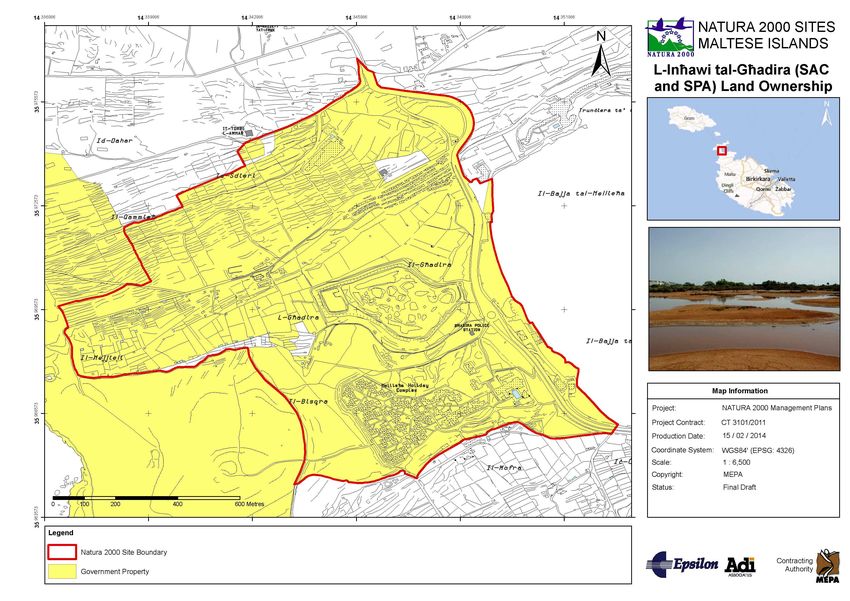
Natura 2000 Management Plan
ANNEX 1 MANAGEMENT PLAN DEVELOPMENTDEVE 4
A.1.1 Summary of Methodology 4
A.1.2 Data Collection 5
A.1.3 Formulation of Management Objectives 5
A.1.4 Formulation of Management Actions 6
A.1.5 Work Plan Structure and Reporting and Review Plan 6
ANNEX 2 RELEVANT PLANNING POLICIES PO 8
A.2.1 Structure Plan and Local Plan Policies 8
ANNEX 3 ASSESSMENT METHODOLOGY
METHODOLO OF CONSERVATION STATUS 26
ANNEX 4 SPECIFICATIONS OF MANAGEMENT
MA ACTIONS 34
A.4.1 Guidelines for Standard Monitoring Plans for Annex I Habitats and Annex II Species of
the Habitats Directive and Annex i Species of the Birds Directive 34
A.4.2 Guidelines for the Elaboration of National Species Action Plans 40
A.4.3 Guidelines for Habitat Restoration Actions 43
P6. Planning and implementation of an IAS Species control / eradication programme 43
A.4.4 Guidelines for the Signposting and Site promotion 49
P7. Elaboration of a study for the design and technical specifications for warning/
information/interpretation signposting and promotion material 49
A.4.5 Patrolling Schedule 53
ANNEX 5 COST RECOVERY MECHANISMS
MECHAN 65
A.5.1 Revenue Generating and Self-financing
Self Opportunities 65
A.5.2 Funding Opportunities 68
ANNEX 6 MAPS 70
A.6.1 Boundary Map 71
A.6.2 Hydrology Map 72
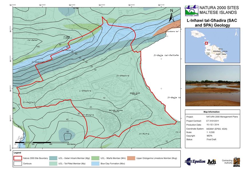
A.6.3 Geology Map 73
A.6.4 Cultural Heritage Map 74
A.6.5 Land Use Map 75
A.6.6 Habitats Map 76
A.6.7 Signage Map 77
A.6.8 Species Map 78
A.6.9 Land Ownership Map 79
A.6.10 Visitor Access Map 80
ANNEX BIBLIOGRAPHY 81
Tables
Table A-1:
1: Structure Plan policies; L-Inħawi
L tal-Għadira ..............................................................
.............................. 9
Table A-2:
2: North West Local Plan policies applicable to L-InħawiL tal-Għadira ........................... 15
Table A-3:
3: Evaluating the current condition of a habitat type....................................................
................................ 27
Table A-4:
4: Evaluating the current condition of a species............................................................
species ............................ 30
Table A-5:
5: Annex I Habitats and Annex II Species to be monitored...........................................
................................ 34
Table A-6:
6: Bird Species to be monitored ................................................................
.................................................... 36
Table A-7:
7: FRVs to be established for the following habitats
ha and species .................................
................................ 37
page A-2 Epsilon-Adi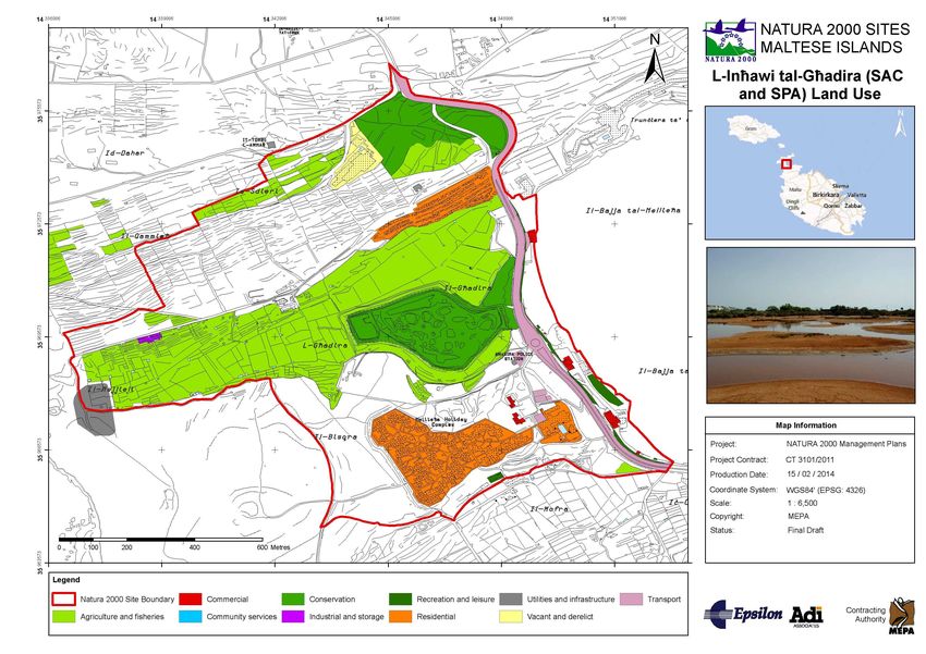
L-Inħawi tal-Għadira

Table A-8: Parameters for determining Favourable Conservation Status according to Article 17
of the Habitats Directive ............................................................................................................. 38
Table A-9: Content explanation of Table A-11: Site Identity – Management Structure ............. 55
Table A-10: Content explanation of Table A-13: Activities per site ............................................ 55
Table A-11: Site Identity – Management Structure ................................................................... 56
Table A-12: Half-year patrolling schedule ................................................................................... 59
Table A-13: Activities per site...................................................................................................... 62

Figures
Figure A-1: Areas for IAS Programme for Action P6 ................................................................... 48
Figure A-2: Map showing indicative locations for sign posting................................................... 52

Epsilon-Adi                                                                                                                 page A-3
Natura 2000 Management Plan

ANNEX 1 MANAGEMENT PLAN DEVELOPMENT

A standardised methodology has been developed for the development of all Natura 2000
Management Plans. The use of a standardised methodology allows for facilitated quality
assurance and control. This chapter outlines the management planning methodology.

A.1.1 SUMMARY OF METHODOLOGY
Step-1      Information acquisition, evaluation: The team acquired information available for
            the site from MEPA, literature, available reports, interviews, consultants and
            academia contacts.

Step-2      Site/s visit & field work: The team conducted site visits as necessary to verify the
            information collected in Step-1 and collected additional information and data (e.g.
            photographs).

Step-3      Database development: The team evaluated all information for consistency,
            quality and reliability and stored information in an ArcGIS system.

Step-4      Drafting of Chapter 3: Based on the above the team drafted Chapter 3 of this
            report. The 1st draft was peer reviewed by the team and external consultants.

Step-5      Drafting of Chapters 4 to 6, Draft-1: Based on the above the team drafted
            Chapters 4, 5 and 6, by following the steps described below and produced a 1st
            Draft of the Management Plan.

Step-6      Public consultation & stakeholders meetings: This is a horizontal action carried out
            concurrently with the above steps. The team organized public consultation
            meetings and public information days with stakeholders and the MEPA, presented
            the Natura 2000 programme for Malta, and acquired general and specific
            information for the sites. It also discussed the vision, management objectives and
            actions for the site.

Step-7      2nd site visit, verification, Draft-2: The team conducted a 2nd site visit to verify
            measures proposed in Draft-1 and produced a Draft-2 Management Plan.

Step-8      Consultation and Draft-3: Draft-2 was peer reviewed by consultants and experts
            and the team used the feedback from these to produce Draft-3.

Step-9      Database update, maps, Live.Doc: Based on the above, the team updated the site
            database and GIS system and produced maps and other information.

Step-10     Delivery of the Live.doc to the MEPA: A presentation was made to MEPA and the
            Live.doc was delivered for review and commenting.

Step 11     The final document is then produced: The live.doc has been circulated, comments
            have been incorporated and the Final Report has been produced

 page A-4                                                                            Epsilon-Adi
L-Inħawi tal-Għadira

A.1.2 DATA COLLECTION
Data has been collated for:

  •   Physical features
  •   Management infrastructure
  •   Relevant plans, policies and legislation
  •   Ecology
  •   Human uses within and around the site
  •   Economic and social aspects including stakeholder consultation.

The data has been collated from various sources according to the procedures:

  •   A desk study was first carried out to gather all relevant data related to the site.
  •   Typical information sources used are MEPA databases, maps and documents,
      information from the Lands Department, information from the Agriculture Department,
      information from the Malta Resources Authority.
  •   Field surveys were carried out to support the desk study.
  •   Surveys were carried out for land use and habitat mapping, in particular to confirm or
      update the habitats maps available at MEPA.
  •   Meetings were held with relevant stakeholders during which the site was discussed and
      information as well as feedback was obtained.
  •   Survey methodologies and details of the consultation carried out are described in detail
      in Chapter 2.

A.1.3 FORMULATION OF MANAGEMENT OBJECTIVES
Compiled data is evaluated in Chapter 3, leading to the vision of the site with the help of a
SWOT analysis as described in the equivalent sections.

The essence of conservation management is the ability to improve the weak features
(weaknesses) and to control the negative factors (threats) impacting a particular feature or
group of features, while enhancing the strengths and increasing the probability of the
opportunities identified.

To aid the process a Prospects Matrix is employed. Principal features targeted for conservation
are plotted against the ecological, social and institutional prospects that can be contemplated
for them and for the site as a whole.

In Natura 2000 sites the ecological prospects are well defined and refer to:

  •   The natural habitat types listed in Annex I of the Habitats Directive
  •   The species listed in Annex II of the Habitats Directive
  •   The species listed in Annex I of the Birds Directive and migratory birds as per Article 4 of
      the Birds Directive
  •   Other important species defined for the site.

Institutional and social prospects are site specific and derived from the evaluation of the
features (other than habitats and species) and the factors influencing the site.

Epsilon-Adi                                                                             page A-5
Natura 2000 Management Plan

Ideally every issue identified in the SWOT analysis should appropriately fit in a cell of the
Prospect Matrix so that a formula for addressing weaknesses and threats and building on
strengths and opportunities can be later constructed.

A vision for the site is then created to summarise the ideal situation after a period of
management of the protected area. The vision is based on the evaluation of the prospects that
can be contemplated for each of the features and the factors identified for the site.

The vision is composed of discrete vision statements. Each vision statement corresponds to a
line in the Prospect Matrix.

The above led to the formulation of the Management Objectives and, subsequently,
Operational Objectives. Operational Objectives are basically the objectives to which all the
management work is directly related and lays the groundwork for management actions.

A.1.4 FORMULATION OF MANAGEMENT ACTIONS
Operational Objectives are given a priority rating, based on urgency for addressing certain
conservation problems (as they have been identified during the evaluation process) and
subsequently lead to the formulation of Management Actions as described in Chapter 4. In
most cases certain actions can be grouped together so that a more comprehensive final list of
Management Actions is produced.

For each action a brief description is given together with expected results, priority ratings and
foreseen constraints. For a number of Management Actions, some of which would be best
implemented horizontally across sites, the aforementioned brief description is supplemented
by specifications which are included in Annex 4. The specifications elaborate further on the
needs of the implementation to facilitate future work.

A.1.5 WORK PLAN STRUCTURE AND REPORTING AND REVIEW PLAN

Prior to the Management Plan implementation a detailed Work Plan must be prepared by the
relevant entity and site manager, on annual basis and reviewed at the end of each year, which
makes clear what is expected to be achieved over specific periods of the plan and how much it
will cost, as is indicated in Chapter 5.

To facilitate the elaboration of the Work Plan the following are provided:

  •   An indication of the financial resources needed annually for the implementation of each
      action.
  •   The annual time schedule for the implementation of each action, checklist of the
      expected deliverables and year of delivery of each action and the entity proposed as
      responsible to deliver the actions.

 page A-6                                                                             Epsilon-Adi
L-Inħawi tal-Għadira

In addition, cost recovery mechanisms are identified, both per site and horizontally, to
facilitate securing resources for the subsequent implementation of the actions suggested
within the Management Plan. These are included in Annex 5.

The management plan should be reviewed on an annual basis and given an in-depth review
immediately after its five year period of validity, as indicated in Chapter 6. It is important to
review the management plan on a regular basis since this:

  •   Makes clear whether or not all the objectives and targets are being achieved efficiently
      and effectively
  •   Allows resource shifting and re-prioritisation if necessary
  •   Assists forward planning for the following year or period, so that uncompleted projects
      can be added in and tasks re-timed in the light of experience.

To facilitate the five year revision plan and specifically the assessment of the appropriateness
of the Operational Objectives, a list of initial performance indicators are also provided.

Epsilon-Adi                                                                            page A-7
Natura 2000 Management Plan

ANNEX 2 RELEVANT PLANNING POLICIES

A.2.1 STRUCTURE PLAN AND LOCAL PLAN POLICIES

 page A-8                                      Epsilon-Adi

L-Inħawi tal-Għadira

Table A-1: Structure Plan policies; L-Inħawi tal-Għadira
   Str.
                                                                                                                                  Relevance to management plan
   Plan                                                        Description
                                                                                                                                             process
  Policy
 SET 11       No form of urban development will be permitted outside existing and committed built-up areas, and primary        The management plan will take note of
              development areas as designated in the Structure Plan even where roads and public utilities are available.       this policy.
              Permitted forms of non urban development outside such areas are restricted to the categories referred to in
              Paragraph 7.6
 SET 12       Notwithstanding the policy against any form of urbanisation outside areas designated for urban uses in the       The management plan will take note of
              Structure Plan, the Planning Authority will consider applications for permission to develop which ostensibly     this policy.
              infringe Policy SET 11. In any such case the onus will be on the applicant to present evidence as to why the
              policy should be infringed, giving reasons why from a planning point of view such proposed use cannot be
              located in areas designated for development. The Planning Authority will additionally require the applicant to
              submit at his own expense a full Environmental Impact Assessment of a form and content satisfactory to the
              Authority. This policy is not a means of evading policy SET 11 or any other policy. An Environmental Impact
              Assessment which adequately demonstrates acceptable impacts will not be a reason for the granting of a
              development permit if the proposed use can be located in an area intended for its development under the
              Structure Plan or any subsequent approved Planning Authority document.
 BEN 5        Applications for development permits outside urban areas will be judged against the policies and design          The management plan will take note of
              guidelines of the Local Plans for Rural Conservation Areas, and in the interim period, to Structure Plan         this policy.
              policies and the guidelines contained in the Explanatory Memorandum.
 AHF 1        Major improvements in agriculture, horticulture, and fisheries will be encouraged, so that:                      A large part of the management plan
                    • The sector assists the overall economy of the country through reduced imports and increased exports      area includes agricultural land.
                    • Better quality products are available to domestic consumers
                    • The countryside land resource is used efficiently and does not become derelict
                    • Food supplies are safeguarded in the event of natural, accidental, or deliberate calamities
                    • The countryside is safeguarded for the benefit of future generations
 AHF 4        Soil conservation and soil saving measures will continue to be mandatory on all occasions. Soil replenishment    Conserving soil is important both for
              measures will be adopted where there are suitable opportunities.                                                 agricultural    reasons      and     for
                                                                                                                               safeguarding of the existing landforms.
 AHF 8        Further measures will be developed to promote the reinstatement and maintenance of random rubble walls           A large part of the management plan
              throughout the countryside with priority given to walls alongside rural roads, and for the removal of visual     area is made up of active or
              intrusions.                                                                                                      abandoned agricultural land.
 RCO 1        Rural Conservation Areas are designated as illustrated in the Key Diagram. Within such areas the following       L-Għadira SAC/SPA has Areas of
              sub areas will be designated, using World Conservation Union definitions and criteria where relevant:            Ecological Importance.

Epsilon-Adi                                                                                                                                                   page A-9
Natura 2000 Management Plan

  Str.
                                                                                                                                       Relevance to management plan
  Plan                                                          Description
                                                                                                                                                  process
 Policy
             1. Areas of Agricultural Value: areas comprised of high grade agricultural land including irrigated and partially
             irrigated land
             2. Areas of Ecological Importance: relatively large areas designated to protect typical and rare habitats
             3. Sites of Scientific Importance: sites containing individual species, groups of species, and geological features
             4. Areas of Archaeological Importance: concentrations of valuable archaeological sites
             5. Sites of Archaeological Importance: individual and/or isolated archaeological sites
             6. National Parks: relatively large areas of national significance not materially altered by human use, with
             managed visitor access and amenities
             7. Areas of High Landscape Value
 RCO 2       Within Rural Conservation Areas and in accordance with Policy SET 11 no form of urban development will be              Rehabilitation may also be considered
             allowed. However, in accordance with Policy BEN 5, applications for permission to develop structures or                as part of the management planning
             facilities essential to agricultural, ecological, or scenic interests will be favourably considered as long as the     process.
             proposed development does not infringe the principles set out in Policy RCO 4 as subsequently detailed in
             the relevant Local Plan (Policy RCO 3). See also Policies RCO 7 and 8. With regard to existing buildings and
             other structures in Rural Conservation Areas, and other rural areas, the overall aim is to improve the rural
             environment. To this end the rehabilitation and suitable change of use of some buildings will be permitted, in
             conjunction with the removal of other buildings and structures which adversely affect the rural environment.
 RCO 4       The Planning Authority will not permit the development of any structure or activity which in the view of the           Since the SAC/SPA already has
             Authority would adversely affect scenic value because it would:                                                        developed pockets of land, this policy
             1. Break a presently undisturbed skyline                                                                               might be relevant in case there will be
             2. Visually dominate or disrupt its surroundings because of its mass or location                                       more proposals for development. The
             3. Obstruct a pleasant and particularly a panoramic view                                                               management plan will take note of this
             4. Adversely affect any element of the visual composition - for example, cause the destruction or                      policy.
             deterioration of traditional random stone walls
             5. Adversely affect existing trees or shrubs
             6. Introduce alien forms, materials, textures, or colours
 RCO 5       In Rural Conservation Areas, permission for the development of new or extended infrastructure (roads,                  The management plan will take note of
             reservoirs, overhead electricity and                                                                                   this policy.
             telephone cables, pipelines, tipping sites, etc.) will only be given if the Planning Authority is satisfied that all
             possible measures have been taken to mitigate the visual impact of the proposed development.
 RCO 6       Following the adoption of the Local Plans for Rural Conservation Areas, the Planning Authority will institute a        The SAC/SPA includes an area that is
             programme of enhancement and management in conjunction with the Ministry of Agriculture and the                        being afforested.

 page A-10                                                                                                                                                       Epsilon-Adi
L-Inħawi tal-Għadira
Str.
Relevance to management plan
Plan Description
process
Policy
Secretariat of the Environment comprising:
1. Afforestation and landscaping schemes
2. Rehabilitation of abandoned quarries
3. Reactivation of abandoned agricultural land, encouraging compatible methods of cultivation
4. Reuse and conversion of rural buildings which are compatible with their scenic setting
5. Rehabilitation of degraded habitats
6. The encouragement of and provision of incentives for the relocation to appropriate existing or planned
urban areas of structures and activities which are incompatible with the creation and maintenance of a high
quality of rural environment.
RCO 7 Structure Plan policies with respect to agriculture generally are set out in Policies AHF 1 to 13. In applying The management plan will take note of
these policies, particular attention will be paid to the needs of designated Areas of Agricultural Value and to this policy.
their importance in the resolution of conflicts with other rural interests in Local Plans.
RCO 8 In Rural Conservation Areas, individual cultivators will be required to illustrate to the Planning Authority how The management plan will take note of
any planned agricultural this policy.
development will not harm the ecological, archaeological, and scenic value of the Area.
RCO 9 In Rural Conservation Areas, individual cultivators will be required to put forward proposals to the Planning A large part of the management plan
Authority for the cultivation of abandoned or derelict agricultural plots and for the restitution of ecologically, area is made up of active or
archaeologically, or scenically valuable environments which have been degraded because of agricultural abandoned agricultural land.
malpractice or neglect. Where scientifically important species have become established on abandoned
agricultural land, they will be protected and no reversion to agriculture will be required.
RCO 10 In identifying and designating Areas of Ecological L-Għadira SAC/SPA includes a saline
Importance in Local Plans, one or more of the following habitat types must be present: marshland, sand dunes and garigue.
1. Permanent springs
2. Saline marshlands
3. Sand dunes
4. Forest remnants
5. Semi natural woodland
6. Natural freshwater pools and transitional coastal wetlands
7. Deep natural caves
8. Coastal cliffs
9. Representative examples of typical Maltese habitats such as garigue, maquis, valley sides, watercourses,
and gently sloping rocky coasts.
Epsilon-Adi page A-11Natura 2000 Management Plan
Str.
Relevance to management plan
Plan Description
process
Policy
RCO 11 In identifying and designating Sites of Scientific Importance in Local Plans, one or more of the following The SAC/SPA is also designated as a
features must be present: Site of Scientific Importance.
1. The only known locality in the Maltese Islands where certain endemic and/or non endemic species are
found
2. A locality where certain endemic and/or non endemic species with a restricted distribution in the Maltese
Islands occur (`restricted distribution' is taken to mean occurrence in five localities or less)
3. The type locality of an endemic species
4. An important bird nesting site or of some other major ornithological interest
5. A locality of special palaeontological interest
6. A lithostratigraphical type section
7. A locality of particular geomorphological interest
8. Some other specific feature of scientific importance not listed above
RCO 12 In Local Plans, the Planning Authority will give protection ratings to Areas of Ecological Importance and Sites The management plan area contains
of Scientific Importance as follows: areas with different protection levels
1. LEVEL 1 zones will include important habitat types present only in small areas and/or sites with unique (see Table 1)
species or features
2. LEVEL 2 zones will include important habitat types present in relatively large areas and/or sites with rare
species or features
3. LEVEL 3 zones will include areas where control is necessary to preserve habitats/species/features in
adjacent sites
4. LEVEL 4 zones will include habitats and/or features of general interest
RCO 16 No form of permanent construction will be allowed in sandy coastal areas and existing constructions will be L-Għadira SAC/SPA includes a sandy
removed wherever practicable. The removal of sand from sandy beaches is prohibited, and the extension and beach and sand dunes.
creation of sandy beaches for recreational use will be encouraged. Sandy beaches include shallow inshore
seabeds. All beach and seabed enhancement will be the subject of Environment Impact Analyses.
RCO 17 Overnight camping on sandy beaches, and any camping on sand dunes will be prohibited, and access of L-Għadira SAC/SPA includes a sandy
vehicles to sandy beaches and dune areas will be prevented. beach and sand dunes.
RCO 18 Without prejudice to any other policy or regulation protecting dune areas, the Planning Authority will L-Għadira SAC/SPA includes a sandy
actively prevent the removal of sand binding vegetation from such areas. beach and sand dunes.
RCO 20 Positive action will be taken to rehabilitate identified areas of degraded habitat and landscape, and proposals The management plan will take note of
from Government agencies and non governmental bodies for rehabilitation schemes for these areas, this policy.
provided that such schemes do not conflict with other policies and/or regulations concerning these areas,
page A-12 Epsilon-AdiL-Inħawi tal-Għadira
Str.
Relevance to management plan
Plan Description
process
Policy
will be supported subject to scrutiny and approval by competent experts.
RCO 21 There is a general presumption against development in areas prone to erosion. The management plan will take note of
this policy.
RCO 22 Positive action will be taken to prevent further loss of sandy beaches, sand dunes, coastal clay slopes, soil, The management plan will take note of
and cliff edges. this policy.
RCO 23 Developments connected with the construction of coastal defences, the enlargement of existing beaches, L-Għadira SAC/SPA includes a sandy
and the creation of new ones will only be allowed following a scientific study by competent persons of their beach.
short term and long term environmental, social, and economic impact, and provided that it is clearly
demonstrated that there is a real need for such development and that the benefits outweigh any negative
impacts.
RCO 24 Existing regulations concerning excavation and transport of sand and soil will continue. The management plan will take note of
this policy.
RCO 25 Positive action will be taken to promote the repair of breached retaining walls on valley sides in order to The management plan will take note of
prevent further soil erosion. this policy.
RCO 26 The removal of the vegetation cover from abandoned fields and derelict land without good reason will not be The management plan will take note of
permitted. this policy.
RCO 27 Developments which involve the excavation of significant quantities of Blue Clays will not be permitted. L-Għadira SAC/SPA includes a small
area of clay slopes.
RCO 28 Valleys will continue to be protected as important water catchment areas. L-Għadira SAC/SPA includes the
Mellieħa Valley.
RCO 29 No new physical development will normally be allowed on the sides of valleys and especially on valley L-Għadira SAC/SPA includes the
watercourses except for constructions aimed at preventing soil erosion and the conservation and Mellieħa Valley.
management of water resources. Also:
1. Existing dams across valleys to conserve water resources will be repaired in preference to the construction
of new dams. Dams will be built of durable materials and will be regularly maintained
2. The Planning Authority will have regard to the possible detrimental effect of dredging works in valleys, and
will seek to minimise the impact of such works, particularly by leaving the valley banks intact and by
promoting selective dredging
3. The Planning Authority will take positive action, in collaboration with the appropriate Government
agencies, in order to prevent the dumping of domestic waste, building rubble, and other refuse into valleys
4. The Planning Authority will take positive action to safeguard valleys for walking, cycling, and horseriding
through the prohibition of vehicles, other than for agriculture and maintenance, and the establishment of car
Epsilon-Adi page A-13Natura 2000 Management Plan
Str.
Relevance to management plan
Plan Description
process
Policy
parks at valley edges.
RC0 30 There is a general presumption against the siting of afforestation projects where stable indigenous (native L-Għadira SAC/SPA includes an area
species) natural vegetational communities are already established, but encouragement of the siting of dedicated to an afforestation project.
afforestation projects on abandoned agricultural land and on derelict ground will be given.
RCO 31 Afforestation projects sites in non urban areas will make use only of indigenous and archaeophytic (brought L-Għadira SAC/SPA includes an area
by man in prehistoric times, and now naturally occuring) species. The use of exotic (not native to the country) dedicated to an afforestation project.
species will be limited to urban areas.
RCO 32 The planting of appropriate species of trees will be encouraged where they enhance the landscape, The management plan will take note of
particularly along roadsides, where they provide a screen to visually unattractive areas, and alongside this policy.
footpaths where they provide shade. Species which attract birds will be encouraged in suitable locations.
RCO 39 Educational programmes aimed at creating positive patterns of behaviour of individuals, groups, and of The Għadira nature reserve has an
society as a whole, towards the environment will be promoted. educational programme for school
children visiting the site.
RCO 41 The establishment of Field Centres by recognised educational institutions will be encouraged, and of The Għadira nature reserve includes a
interpretive Visitor Centres associated with Conservation Areas, providing that these are established in field centre.
harmony with other policies and regulations.
ARC 2 In making the designations referred to in Policy ARC 1, the Planning Authority will give protection ratings as L-Għadira SAC/SPA includes a small
appropriate to local circumstances as follows: area designated as Class B cart ruts.
Class A: Top priority conservation. No development to be allowed which would adversely affect the natural There is also a buffer area around the
setting of these monuments or sites. A minimum buffer zone of at least 100m around the periphery of the cart ruts.
site will be established in which no development will be allowed.
Class B: Very important to be preserved at all costs. Adequate measures to be taken to preclude any damage
from immediate development.
Class C: Every effort must be made for preservation, but may be covered up after proper investigation,
documentation and cataloguing. Provision for subsequent access shall be provided.
Class D: Belonging to a type known from numerous other examples. To be properly recorded and catalogued
before covering or destroying.
CZM 3 Public access around the coastline immediately adjacent to the sea or at the top of cliffs (including in bays, The management plan will take note of
harbours, and creeks) will be secured. This will include taking shorelands into public ownership, Government this policy.
acquisition of illegal developments and encroachments, and suitable construction works. In the few cases
where this is not practical (for example where security considerations are paramount), nearby detours will be
established. All the coastline will be brought into public ownership within a specified period.
page A-14 Epsilon-AdiL-Inħawi tal-Għadira
Table A-2: North West Local Plan policies applicable to L-Inħawi tal-Għadira
L. Plan Relevance to management plan
Description
Policy process
NWAG MEPA will continue to protect agricultural land from all types of inappropriate development. Within “Areas of Agriculture is one of the principal land
1 Agricultural Value” as indicated on Map 4 only buildings, structures and uses essential to the needs of uses in the SAC/SPA.
agriculture will be permitted and then only if it can be demonstrated to the satisfaction of MEPA that they
will not adversely affect water supplies, soil and landscape, and accord with all other policies within this Local
Plan. Applications for development permission for agricultural related developments, which will result in the
subdivision of land holdings, will not be permitted.
This will also apply to other land being cultivated for agricultural use and which in the opinion of MEPA (after
consultation with the Department of Agriculture) has a realistic potential to be upgraded and sustainably
improve its productivity. (This policy will not apply to such land where it is designated for other purposes in
the Local Plan).
Improvements to existing agricultural land and buildings aimed at increased productivity will be favourably
considered by MEPA providing they are well designed, efficient and contribute to rather than detract from
the quality of the local and surrounding environment.
NWAG The reclamation of abandoned or derelict land for agricultural purposes including viticulture or afforestation Agriculture is one of the principal land
2 will be supported providing the land is not designated, protected or scheduled for other purposes in the Local uses in the SAC/SPA. This includes
Plan or, otherwise of ecological, scientific, landscape and/archaeological importance. abandoned land.
NWTO MEPA will favourably consider the upgrading of existing tourist accommodation in rural areas, including The L-Għadira SAC/SPA includes an
2 coastal areas outside the development zone, provided the proposed development: abandoned hotel in Is-Sdieri area.
i. Has obtained the prior approval of the Malta Tourism Authority;
ii. Is kept within the established curtilage of the tourist accommodation facility which has already been
committed with physical, legal development;
iii. Will not adversely affect the visual integrity of the existing building/s or the landscape character of the
area;
iv. The scale and mass of the proposed development will integrate positively with the surrounding
environment; and
v. Complies with established standards of access and off-street parking provision, coach parking facilities and
alighting points.
The increase in the number of beds of existing tourist accommodation in rural areas, including coastal areas
Epsilon-Adi page A-15Natura 2000 Management Plan
L. Plan Relevance to management plan
Description
Policy process
outside the development zone, will not normally be favourably considered by MEPA.
The total re-development of existing tourist accommodation facilities in rural areas, including coastal areas
outside the development zone, will only be considered in very exceptional cases where the new proposal is
for a hotel and has a very high design quality and considerably improves the rural or coastal landscape. Even
in such rare cases, the increase in the number of beds and/or the intensification of the existing uses will not
normally be favourably considered.
NWRE The development of touring caravan and camping sites will be permitted, subject to the following criteria: - Camping and caravans are present in L-
2 i. Applications to comply with Policy Guidelines for Touring Caravans and Camping Sites as approved by Għadira and Marfa areas. The
MEPA; management plan will take note of this
ii. the site is not located on a scheduled, designated, or protected area including the following:- policy.
a. Areas of Ecological Importance,
b. Sites of Scientific Importance,
c. Areas or Sites of Archaeological Importance,
d. Areas of High Landscape Value,
e. Nature Reserve,
f. Areas designated as Public Access Zones
g. Special Areas of Conservation
h. Areas of Agricultural Land
iii. the location, scale and layout, is consistent with protecting the landscape character of the area;
iv. the siting has no significant adverse impact on adjacent protected areas, ground water vulnerability, or
nearby settlements;
v. the site is well related to an existing highway, the access does not cause a traffic hazard, and adequate off-
road parking is provided;
vi. no buildings/structures other than toilets and communal facilities will be permitted to be erected;
vii. static permanently stationed caravans will not be permitted;
viii. no tent will be permitted to be erected for a period in excess of twenty eight days;
ix. no change of use from recreational use to residential use will be permitted;
x. details of water supply, washing and toilet facilities, drainage and sewage disposal arrangements, refuse
disposal and fire prevention shall be submitted and approved; and
xi. a landscape scheme is submitted and approved with any permit application, which shall be implemented
in its entirety within the first planting season and thereafter maintained.
NWRE Existing and proposed long distance footpaths and other access ways will be protected from any L-Għadira SAC/SPA includes various
page A-16 Epsilon-AdiL-Inħawi tal-Għadira
L. Plan Relevance to management plan
Description
Policy process
6 development that would adversely affect their route or character. footpaths, the main one crossing the
Għadira Isthmus.
MEPA in conjunction with Local Councils and other agencies will initiate a system of recording and way
marking of footpaths and access ways.
MEPA will encourage Government to prepare legislation to secure and protect public rights of access to
designated footpaths.
The network of footpaths as indicated on Map 11 and described below, will be integrated wherever possible
with the Country Parkway System (Refer to Policy NWRE5). Emphasis will be given to the provision of circular
routes and access from the urban settlements to the countryside.
i. Marfa - the ridge and the varied coastline of the peninsula, incorporating the Red and White towers, Ras il-
Qammieh and the Madonna Statue;
ii. Northern Coastline - eastern and western coastlines in the vicinity of Mellieha and the wooded area of il-
Mizieb;
iii. Western Cliff Rim - the crest of the western cliffs from Mgarr, via Mtahleb and Dingli Cliffs south to Ghar
Lapsi, with a diversion to Ras il-Pellegrin;
iv. Dingli Plateau - the Dingli - Nadur plateau, including Ghemieri, Dingli cliffs, Il- Qolla and Chadwick Lakes;
v. Widien and Wardija - St Paul’s Bay combined with the ridge crest;
vi. Victoria Lines - east-west walk between Gharghur and Bahrija following the crest of the Victoria Lines
escarpment, forts and fortifications including Bingemma; and
vii. Mgarr Walk - Misrah Miel cliff top, near Gnejna, north to Ghajn Tuffieha, and east to Il-Fawwara and the
Roman baths.
NWRE MEPA proposes, in conjunction with the Malta Maritime Authority, a swimming zone at Gnejna Bay in Il- Bajja tal-Mellieha is a swimmers
12 addition to existing designated sites as indicated on Map 14: zone (Local Notice to Mariners No 31
i. Ir-Ramla tal-Mixquqa (Golden Sands) of 2012).
ii. Ir-Ramla ta’ Ghajn Tuffieha
iii. Il-Bajja tal-Mellieha
iv. Il-Bajja tac-Cirkewwa (Paradise Bay)
v. Il-Bajja ta’ San Pawl
vi. Il-Bajja ta’ L-Imgiebah
NWRE MEPA in conjunction with the Department of Estates Management and the Malta Tourism Authority will seek L-Għadira SAC/SPA includes the largest
Epsilon-Adi page A-17Natura 2000 Management Plan
L. Plan Relevance to management plan
Description
Policy process
16 to ensure that existing beach concessions and/or encroachments do not contribute to the decreasing areas sandy beach in the Maltese Islands.
available for use by the general public.
There will be a presumption against the granting of development permission for any further beach
concessions or encroachments on the coast and foreshore.
NWRE MEPA may permit the construction of new Beachroom Holiday Accommodation, together with the provision L-Għadira SAC/SPA includes a number
18 for electricity, sanitary facilities and sewage disposal, in locations as identified in the Marfa Action Plan. of beachrooms that are located close
Occupation shall be strictly limited to temporary holiday accommodation and no change of use from holiday to the nature reserve.
to permanent
residential or commercial use shall be permitted.
MEPA will permit the change of use of existing boathouses to beachroom
accommodation at specified locations at Mellieha and Bugibba/Qawra as identified in the Area Policies
NWML 11 and 18 and NWSP 13 and at Xemxija below Triq Dawret in-Nawfragju.
MEPA may impose a condition on any permission granted that would remove permitted development rights
under the Schedule of the Development Notification Order 2001, in order to protect the character of the
development
NWTR MEPA will assist the Malta Transport Authority (ADT) and the Local Councils to improve junctions on the The junction improvements have been
8 strategic road network, particularly where buses, pedestrians and cyclists experience delays. introduced. A roundabout has been
created at the junction leading to
General Policy Map 15 and the relevant Area Transport Strategy Maps indicate the following junctions where Marfa, L-Aħrax and the Red Tower.
improvements will be required, as part of the on-going development of the Strategic Road Network:
i. Redesign of junction at access to Marfa Ridge (Triq l-Armier) and Il-Batterija Ta' Wied Musa (Map 15);
ii. The Triq il-Mithna L-Qadima junction together with a section of the Mellieha Bypass will be upgraded as
part of the Ta’ Masrija redevelopment (Maps 15 and 24);
iii. Improve junction leading to Mellieha Bay Hotel (Maps 15 and 34);
iv. Junction leading to Qawra and Kennedy Grove and junction on the Coast Road with Triq is-Salina (Maps 15
and 38);
v. Junction improvements adjacent to the Ghajn Tuffieha car park (Maps 15 and 57);
vi. Junction improvement at main access to Ta’ Qali (Map 15);
vii. Redesign of junction at Vjal il-Haddiem/Triq l-Gheriexem, Rabat (Maps 15 and 62).
page A-18 Epsilon-AdiL-Inħawi tal-Għadira
L. Plan Relevance to management plan
Description
Policy process
No development permissions will be issued for any project, which in the opinion of MEPA might adversely
affect the satisfactory improvement of these junctions. Where major developments will produce a material
adverse impact at junctions, in terms of safety and/or congestion, MEPA will require the developer to
undertake improvements or mitigating measures.
NWLA Designated areas of scenic, cultural and scientific importance will be protected, maintained and enhanced The management plan will take note of
1 through the exercise of strict control over development and the introduction of countryside management this policy.
measures. Emphasis will be given to their appreciation by the community and promotion of their qualities.
NWCO Sites of Scientific Importance (Geological) are designated to regulate conservation in accordance with Section L-Għadira SAC/SPA includes SSIs.
3 46 of the Development Planning Act (1992), and development will only be permitted where it accords with
specific criteria for SSI’s Level 1 – 4 as stated below:
i. Level 1. No development will be permitted and access will be limited except for necessary rehabilitation
works and to enhance the educational use of the area without damaging the features being protected;
ii. Level 2. Permission will only be granted for the maintenance of existing
structures and construction of minor amenities such as footpaths and nature trials designed to enhance the
educational use of the area;
iii. Level 3. Permission may be granted for small-scale informal recreation
development subject to a satisfactory Environmental Impact Assessment
being undertaken and approved by MEPA;
iv. Level 4. Permission will only be granted for small-scale development provided that no suitable alternative
locations exist and features of geological and scientific interest are protected. A satisfactory Environmental
Impact Assessment is to be undertaken and approved by
MEPA.
NWCO Areas and sites of Archaeological Importance, as indicated on Map 18, are designated to regulate their L-Għadira SAC/SPA includes a small
4 conservation in accordance with Section 46 of the Development Planning Act (1992), and development will area designated as Class B cart ruts.
only be permitted where it accords with specific criteria for SSIs Level 1- 4 as stated in this policy. There is also a buffer around the cart
ruts.
Protection Rating CLASS A
No development will be permitted which would adversely affect the monument or site or its setting. A
minimum buffer zone of at least 100m around the periphery of the site will be established in which no such
development will be allowed.
Locations of Class A Archaeological Sites …
Epsilon-Adi page A-19Natura 2000 Management Plan
L. Plan Relevance to management plan
Description
Policy process
Protection Rating CLASS B
No development will be permitted which would adversely affect the monument or site or its natural setting.
A buffer zone of at least 50 m will be identified, its size dependent on the level of protection appropriate to
the specific site or area, in which no such development will be allowed.
Protection Rating CLASS C
No development will be permitted within the site or area of archaeological importance until the applicant has
submitted a written scheme of investigation, which has been approved by the Superintendence of Cultural
Heritage. Adequate opportunities must be provided for the recording and, where necessary, the excavation
of such sites. Before a permit is issued, agreement must be reached to cover provision for detailed ground
and structural surveys, excavation in advance of development, the conservation of remains in-situ, and on
the carrying out of a monitoring report as the development proceeds. Provision for subsequent access and
presentation of the area or site shall be made.
Protection Rating CLASS D
No development will be permitted within the site or area of archaeological importance until the applicant has
submitted a written scheme of investigation, which has been approved by the Superintendence of Cultural
Heritage. Adequate opportunities must be provided for the recording and, where necessary, the excavation
of such sites. Before a permit is issued, agreement must be reached to cover provision for detailed ground
and structural surveys, excavation in advance of development, the conservation of remains in-situ and on the
carrying out of a monitoring report as the development proceeds. Where possible provision for subsequent
presentation of the area or site shall be made.
Protection Rating CLASS E
Where applications for development permission are submitted on a site or area in which the
Superintendence of Cultural Heritage or MEPA may have some archaeological interest, the applicant will be
required to undertake an investigation including excavation if necessary. If following investigation, the
Superintendence of Cultural Heritage considers the site to be of archaeological value, MEPA will normally
refuse development permission if the proposed development would lead to the destruction of the site, or
require the development to be modified so that the archaeological value of the site is protected.
NWCO Areas of Ecological Importance (AEIs) and Sites of Scientific Importance (SSIs) are designated to regulate their L-Għadira SAC/SPA includes AEI-SSIs
6 conservation in accordance with Section 46 of the Development Planning Act 1992 and development will only (see Table 1).
be permitted in accordance with the level of protection required within the appropriate grading.
page A-20 Epsilon-AdiL-Inħawi tal-Għadira
L. Plan Relevance to management plan
Description
Policy process
General Protection will apply as follows: -
i. No inappropriate development to the rural countryside will be permitted. However, suitable maintenance
of existing structures and construction of minor amenities designed to enhance the conservation or
educational use of any area may be permitted. Supervised visits to sites of natural importance will be
encouraged in
order to increase public awareness;
ii. no development activities that are likely to be a fire risk to trees and wooded areas will be allowed;
iii. no development where noxious emissions, effluents or waste are likely to create an adverse impact on
nearby AEIs or SSIs will be allowed.
iv. The removal of intrusive elements and alien species in a manner compatible with conservation; and the
inclusion of buffer zones to further the protection of AEIs and SSIs.
Level 1 AEIs and SSIs (Ecological)
A L-Għadira …
No development will be permitted and access will be limited except to enhance the educational use of the
area whilst not damaging the features being protected and for necessary rehabilitation works.
Locations of Level 1 Ecological Sites …
Level 2 AEIs and SSIs (Ecological)
Permission will only be granted for the maintenance of existing structures, covered by a permit and
construction of minor amenities where permissible, designed to enhance the educational and recreational
use of the area (e.g. narrow footpaths, nature trails and small scale visitor centres).
Level 3 AEIs and SSIs (Ecological)
No residential, industrial, commercial, tourism development, infrastructure or public utility works will be
permitted. A satisfactory environmental impact assessment is to be
undertaken and approved by MEPA.
Epsilon-Adi page A-21Natura 2000 Management Plan
L. Plan Relevance to management plan
Description
Policy process
Level 4 AEIs and SSIs (Ecological)
Permission will only be granted for small-scale development provided that no suitable alternative locations
exist and features of ecological and scientific interest are protected.
A satisfactory environmental planning statement is to be undertaken and approved by MEPA.
NWCO MEPA will encourage small scale development proposals that support visits by the public to appropriate sites The management plan will take note of
7 for educational purposes in order to increase awareness of the importance of the Islands heritage. this policy.
Proposals, which through proper management and interpretation can preserve/conserve the cultural,
recreational, ecological, educational and tourist potential of the built and natural heritage sites will be
supported and promoted.
Sites for public presentation must be well managed and subject to the following objectives and criteria: -
i. the development has minimal adverse visual impact or other impact on the character or setting of the site;
ii. the development does not damage or otherwise adversely affect the cultural or natural heritage value of
the site;
iii. in appropriate areas, the regeneration or reintroduction of indigenous plants and animals and their
habitats;
iv. visitor education through sign posting/way marking, interpretation boards and permanent exhibitions, e.g.
visitor centres (utilising existing buildings wherever possible);
v. adequate and safe access for visitors to the site and where appropriate, provision for vehicle parking which
does not adversely affect the setting of the site;
vi. visitors are managed according to the carrying capacity or resilience of each site, so as to minimize visitor
impact on the site, and
vii. there is no conflict with other policies of this Local Plan (especially those for the protection of the rural
environment).
The Plan identifies the following sites, which need immediate protection and enhancement, and puts forward
detailed policies listed against these sites in order to secure proper management.
… L-Għadira and Is-Simar Bird Sanctuaries Policy NWCO 8 …
NWCO The area of sanctuaries for birds within the existing Nature Reserves at l-Għadira, Is-Simar and Ta’ Qali will be L-Għadira SAC/SPA includes a bird
8 enlarged. MEPA will initiate and support the establishment of managed nature reserves as indicated on Map sanctuary.
page A-22 Epsilon-AdiL-Inħawi tal-Għadira
L. Plan Relevance to management plan
Description
Policy process
18 based on areas of ecological importance and/or sites of scientific importance and will seek to enter into
management agreements with the landowners, local councils, non-government organisations and others to
ensure the long-term protection and enhancement of such reserves.
No development of any kind will be permitted within the boundary except for suitable maintenance of
existing structures and construction of minor amenities designed to enhance the conservation or educational
use of the area.
NWCO Woodland Conservation Areas are designated, as illustrated on Map 20, for protection and no development The SAC/SPA includes an area that is
10 will be permitted, which in the opinion of MEPA, will be detrimental to the ecosystem of these areas. being afforested.
MEPA in conjunction with the relevant government agencies, NGOs and land owners, will encourage the
planting and maintenance of indigenous trees in Woodland Conservation Areas unless this is deemed to be
detrimental to the forest remnants or established maquis and woodland areas or other natural habitats. The
use of woodland for passive recreation activities will be encouraged. Planting shall aim at an ecological
approach to the sites and shall be in accordance with the Supplementary Planning Guidance on “Trees,
Shrubs and Plants for Planting and Landscaping in the Maltese Islands”.
MEPA will support and protect potential sites identified by PARK Department for development and
management as Areas of Afforestation, in order to safeguard future options and prevent inappropriate
allocation and use of the land.
Woodland Conservation Areas are listed below-
Planted Areas
... Is-Sdieri ...
Afforestation Projects are listed below –
Short Term
… L-Għadira …
NWCO Wherever possible, MEPA will protect areas of garrigue as indicated on Map 22, from activities that create L-Għadira SAC/SPA includes an area of
13 adverse impact. The illegal deposit of soil, or the use for off-roading on such areas will not be permitted. Off- garrigue (e.g. Il-Bisqra).
roading has been identified as a problematic issue within the SAC.
NWCO In accordance with Structure Plan Policy AHF 8, MEPA will encourage the appropriate Government agencies The management plan will take note of
14 including the Department of Agriculture and Local Councils, to promote a Grant Scheme to assist farmers and this policy.
landowners to reinstate and maintain random rubble walls throughout the countryside with priority given to
walls alongside rural roads and tracks, and the removal of visual intrusions, provided that the alignment of
Epsilon-Adi page A-23Natura 2000 Management Plan
L. Plan Relevance to management plan
Description
Policy process
existing rubble walls is retained. There will be a strong presumption against widening of countryside roads,
carriageways or footpaths.
All Giren (Corbelled Stone Huts) within the Local Plan area, are protected pending their official scheduling
under Section 46 of the Development Planning Act. In the interim, all such structures shall be afforded the
same protection as Grade 1 scheduled property under Structure Plan Policy UCO 7. The SAC includes
rural structures like the Giren (Corbelled Stone Huts).
NWCO MEPA will establish, in conjunction with the appropriate agencies, those areas of land suitable for a Part of the Għadira SAC/SPA falls in the
15 Countryside Management approach and introduce, wherever possible, a programme to reconcile land use, area of the Marfa Action Plan.
enhance environmental conservation and provide improved accessibility for public enjoyment.
Areas identified in this Local Plan include –
Burmarrad National Country Park,
Il-Buskett,
Marfa Action Plan Area,
Ta’Qali Action Plan Area,
Country Parkways,
Long Distance Footpaths.
Victoria Lines,
Chadwick Lakes and Environs.
Fort Campbell,
Wied il-Ghasel Valley, Naxxar.
NWML To resolve competing spatial demands on Għadira Bay and its environs by giving priority to the conservation This policy is an overall strategy for the
18 and management of the natural and cultural environment of the area, including the landscape, and Għadira SAC/SPA. The management
protecting it from environmentally unsustainable development whilst reducing congestion and its adverse plan will take note of this policy.
environmental impacts, and improving the overall environmental quality of the area.
(i) Protect and enhance the natural and cultural environment by:
Maintaining all current statutory protection levels
Prohibiting development, which adversely affects statutory protected areas
Identifying further terrestrial and marine areas/sites for protection
Identifying opportunities for environmental enhancement
Ensuring that only the infrastructure project of the wastewater treatment plant is permitted on protected
page A-24 Epsilon-AdiL-Inħawi tal-Għadira
L. Plan Relevance to management plan
Description
Policy process
sites and that associated environmental impacts are properly evaluated and mitigation measures provided
(ii) Improve transportation problems by:
Managing access
Improving pedestrian safety
Improving the bus terminus
Managing car-parking provision
Encouraging traffic management schemes
Encouraging junction improvements
Realigning sections of the dual carriageway
(iii) Control tourism related development by:
Identifying tourism related development opportunities on existing tourism development sites
Defining boundaries and policy constraints for tourism related development opportunity areas on existing
tourism development sites
Prohibiting establishment of new tourism related facilities outside the identified areas
(iv) Manage recreation activities by:
Safeguarding the beach for public use
Safeguarding the swimming zone for bathers
Improving facilities for water sports
Rationalising commercial use of beach
Rationalising the development of beachroom accommodation
Encouraging improvements to the promenade for pedestrians
Safeguarding the Nature Reserve as a recreational use
Considering a beach management plan
Identifying opportunities for environmentally friendly recreation
Epsilon-Adi page A-25You can also read