AXBRIDGE NEIGHBOURHOOD PLAN
←
→
Page content transcription
If your browser does not render page correctly, please read the page content below
2032
                      AXBRIDGE
                  NEIG HBOU RHOOD PL AN

     Shaping the future of our town
     A Neighbourhood Plan gives a voice to the town’s residents in
     how they would like the town to be developed. This
     document re ects the views of Axbridge people and will
     shape development between 2020 and 2032.

                                                                     PAGE 1
fl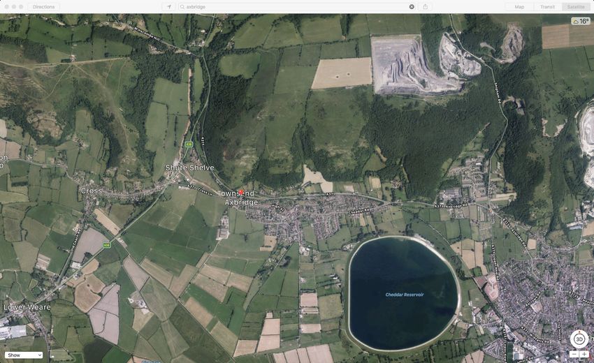
PAGE 2
CONTENTS
                                               Page                                                      Page

Chapter 1 - Legislation and Process             4      Chapter 7 - Aspirations                           44
Overview                                        4
How the plan was developed                      4      Appendix 1                                        46
                                                       Axbridge Town Design Statement
Chapter 2 - About Axbridge                      6
                                                6      Appendix 2                                        52
The Neighbourhood Plan Area
                                                7      Sustainability in Axbridge
The Community
Vision for Axbridge                             9      Appendix 3                                        54
                                                       Axbridge Town Council Affordable Housing Policy
Chapter 3 -Housing and Development              10
                                                14     Appendix 4                                        56
Aims and Objectives
                                               14-19   Call for Sites Advertisement & Assessment Forms
Policies
                                                       Appendix 5                                        65
Chapter 4 - Community and Infrastructure        20
                                                       Results of 2011 Census
Aims and Objectives                             22
                                               23-27   Appendix 6                                        70
Policies
                                                       Evidence Base

Chapter 5 - Historic and Natural Environment    28     Appendix 7                                        73
Aims and Objectives                             31
                                                       Preferred Zones for Development
Policies                                       32-35
                                                       Appendix 8                                        75
                                                36     Maps
Chapter 6 - Transport
Aims and Objectives                             40
Policies                                       41-43

                                                                                                                PAGE 3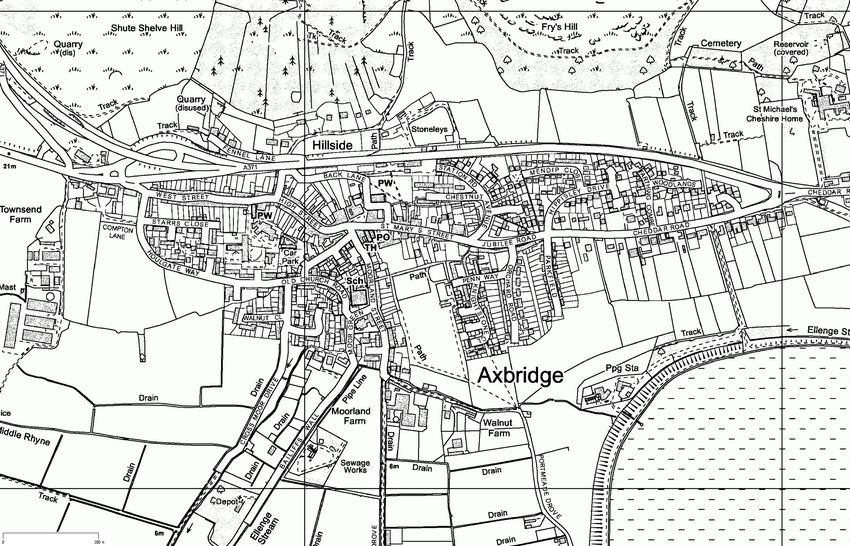
CHAPTER 1
       AXBRIDGE NEIGHBOURHOOD PLAN: LEGISLATION AND PROCESS
     Overview                                                                     1.4. Axbridge Neighbourhood Plan, when adopted, will form part of the
                                                                                      development plan as de ned by s38 of the Planning and Compulsory
     1.1. The Axbridge Neighbourhood Plan (ANP) has been produced to
                                                                                      Purchase Act 2004 and will be used in conjunction with the Local Plan to
        support the Government’s approach to planning as contained in The
                                                                                      determine planning applications that are submitted for the area covered
        Localism Act 2011. The intention of the Act is to allow local people to
                                                                                      by the Plan, namely the Parish of Axbridge, unless material
        have a greater say on development in their area. This Neighbourhood
                                                                                      considerations indicate otherwise (para 2 NPPF 2019).
        Plan re ects the core themes of the Sedgemoor District Council (SDC)
        Local Plan (LP) as adopted 20 February 2019, and also conforms to the
                                                                                  How the Plan was developed
        National Planning Policy Framework, February 2019 (NPPF).
                                                                                  1.5. Axbridge Town Council established the Axbridge Neighbourhood
     1.2. The NPPF was rst published in 2012 (with amendments in 2018 and             Planning Group (ANPG) in September 2015. The objectives were to
        2019) to replace previous national planning statements. A key element         allow local people to have a greater say on development within
        of the policy is the presumption in favour of sustainable development         Axbridge and for the Town to bene t from the enhanced Community
        that requires planning authorities to assess economic, social and             Infrastructure Levy (CIL) payments resulting from an adopted
        environmental impacts.                                                        Neighbourhood Plan.

     1.3. Paragraph 16 of the NPPF requires plans to ‘be prepared with the        1.6. In May 2016 a consultation event was held focused on Axbridge Town
        objective of contributing to the achievement of sustainable                   Hall and the Town Council stall in the farmers’ market. The event
        development’. The Axbridge Neighbourhood Plan is aligned with this            provided an opportunity to discuss the development of the
        objective of the NPPF.                                                        Neighbourhood Plan and the issues that people felt important for
                                                                                      Axbridge.

                                                                                                                                                      PAGE 4
fl
            fi
                 fi
                             fi
1.7 As well as the general discussions, people were asked to identify what                               http://www.axbridgeneighbourhoodplan.co.uk/second-consultation-
                             they liked about Axbridge and what they would like to change. Many                                      results/
                             people lled in a pro forma that gave the two questions; others used
                                                                                                                            1.10. A lea et containing high level results from the 2018 consultation was
                             yellow post it notes and boards provided for the answers. Details of this
                                                                                                                                 produced and distributed to all Axbridge households and businesses.
                             initial consultation can be found at:
                                                                                                                                 As well as summarising the consultation ndings, the lea et also asked
                             http://www.axbridgeneighbourhoodplan.co.uk/initial-consultation-2/                                  for additional comments and welcomed further ideas and support for
                                                                                                                                 the Axbridge Neighbourhood Planning Group. A copy of the lea et can
                         1.8. In November 2016 questionnaires were issued to every household and                                 be found at: http://www.axbridgeneighbourhoodplan.co.uk/wp-
                             businesses in Axbridge. The 339 questionnaires that were returned by                                content/uploads/2018/07/Newsletter-June-2018.pdf
                             January 2017 were collated and the ndings published on the Axbridge
                             Neighbourhood Plan website:                                                                    1.11. The draft plan was opened for comment on 8th December 2019 via the
                                                                                                                                 Neighbourhood Plan website. This was publicised throughout the town
                              http://www.axbridgeneighbourhoodplan.co.uk/survey-results/                                         via the Town Council’s newsletter and yers in local shops and at the
                                                                                                                                 farmers market. Comments were sought and resulted in 9 written
                         1.9. Following analysis of the survey results and consultation feedback                                 submissions. The content of these has been discussed and considered.
                             speci c Aims, Objectives and Policies were developed along with ve
                             Development Zones. The idea behind the Zones was to obtain speci c                             1.12 Formal Reg 14 consultation was undertaken from 23rd April until 20th
                             feedback from the Axbridge community on their preferences for sites of                              June. Submissions were invited from 135 organisations along with all
                             future development (See Appendix 7). A second round of consultation                                 residents. 23 submissions were received and a number of revisions
                             consisting of a further household survey (March 2018) and Town Hall                                 made to the draft plan.’
                             meeting (April 2018) were then undertaken. The results of this

                                                                                                                                    339
                             consultation can be seen at:
                                                                                                                                                            RESPONDENTS TO THE
                                                                                                                                                                QUESTIONNAIRE
                    Axbridge Neighbourhood Plan - Timeline

                    Project    De ne    First     Survey to all       Gather    Results on Evaluation of Policies     Draft policy Re ne &        Draft to Reg. 14 pre- Submission to Independent Community Plan
                     start     Scope consultation households         evidence    Website      results   developed     consultation create draft community submission Sedgemoor DC assessment Referendum adoption
                                                                                                                                      plan                 consultation

                    Spring              Spring           Winter                      Spring                  Autumn     Spring                Winter     Spring      Autumn        Winter       Spring Summer
                     2015                2016            2016                         2017                    2017       2018                 2019        2020        2020         2020          2021   2021

                                                                                                                                                                                                     PAGE 5
fi
     fi
          fi
               fi
                    fl
                                                    fi
                                                           fl
                                                                fi
                                                                                fl
                                                                                              fl
                                                                                                   fi
                                                                                                        fi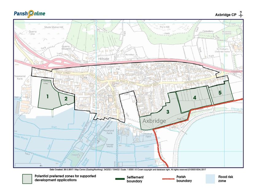
CHAPTER 2
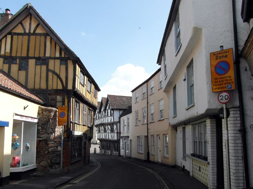
2.2. Axbridge is the smallest town in Somerset. It has developed from an
Anglo-Saxon Burgh and has a medieval square, several narrow medieval
streets and a conservation area with a total of 90 listed buildings1.
ABOUT AXBRIDGE Signi cant listed buildings include the church of St John the Baptist,
King John’s Hunting Lodge and The Old Drugstore. There are more
The Neighbourhood Plan Area recent housing developments that radiate out from the conservation
area (Housing styles and types are discussed more fully in Chapters 3
2.1. The Town of Axbridge is located within the setting of the Mendip Hills
and 5).
Area of Outstanding Natural Beauty (AONB). It is bounded to the north
by the hills and the designated AONB area, and to the South by flood 2.3. The ANP covers the whole of the parish of Axbridge including the area
plain, farmland and open-views out to the country side and the parishes with in the settlement boundary together with the rural area of the
Axbridge CP
of Cheddar and Compton Bishop to the East and West respectively. Levels and Moors to the South and the Mendip Hills AONB to the North.
Shute Shelve Hill Axbridge Hill Fry’s Hill 2.4. The beauty and variety of the countryside within and around the parish,
along with its rich cultural heritage, play a fundamental part in de ning
the Axbridge environment that is so loved by its residents and underpins
the policies within the ANP.
Also see map on p.27 and
p.78 showing the wider
area of the AONB
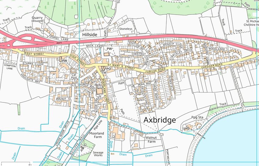
Date Created: 20-5-2017 | Map Centre (Easting/Northing): 343252 / 154452 | Scale: 1:6500 | © Crown copyright and database right. All rights reserved (0100051834) 2017
Parish Boundary Settlement Boundary AONB Flood Risk Zone
In this plan all details for footnotes and relevant web links can be found in the Evidence Base Appendix 6.
Crook Peak at the western edge of the Mendips
1 See evidence base for a full inventory of listed buildings in Axbridge.
PAGE 6
fi
fi
2.7. The town’s size, which in turn is intimately tied to its geographical and
                                                                                                environmental limits, generates a sense that most people feel able to
                                                                                                know or get to know others in the town. Practically all of the addresses
                                                                                                in the town and the central facilities of The Square are within reasonable
                                                                                                walking distance.

                                                                                            2.8. Whole-town events are very well attended and generate wide networks
                                                          Axbridge from Cheddar Reservoir       of friendship and collaboration, such as those organised by the
                                                                                                Axbridge Sports and Social Committee. Examples include Axbridge Fun
       The community
                                                                                                Day held on the Furlong and Father Christmas in the Square, the
                                                                                                Blackberry Carnival, The Civic Service and Rumble in the Jumble.
       2.5. At the last census Axbridge had a population of 2,0572. Appreciation of
           the community spirit of Axbridge was a highly conspicuous element in
                                                                                            2.9. The most impressive of town events is undoubtedly the ten-yearly
           the ANP 2017 consultation. This was fully con rmed by the 2018
                                                                                                Axbridge pageant. The town is immensely proud to hold this event
           household survey, with 96% of respondents saying they particularly
                                                                                                illustrating its history over the last
           valued the community spirit of the town3.
                                                                                                2000 years. It takes place in
                                                                                                the Town Square and
       2.6. It is dif cult to de ne exactly ‘a sense of community’. Some aspects, such
                                                                                                involves over 400
           as Axbridge Square, have a clear physical reality, while others – the
                                                                                                residents.
           willingness of individuals to help others and participate in community
           activity for instance4 – are less tangible. The Square, pubs, cafe and
           restaurants and the Farmers’ Market were the most highly rated physical
           features contributing to community spirit, closely followed by social
           events, the reservoir, and the Town Hall. To preserve the sense of
           community in Axbridge, policy must be guided by a need to maintain
           and increase social activities and amenities.

2 Census     2011. Also see Appendix 5.
3 Community     Consultation Question 20 & 21.
4 See    https://axbridge-tc.gov.uk/organisations/                                                                                                   Axbridge Pageant 2010

                                                                                                                                                                   PAGE 7
  fi
                   fi
                                                     fi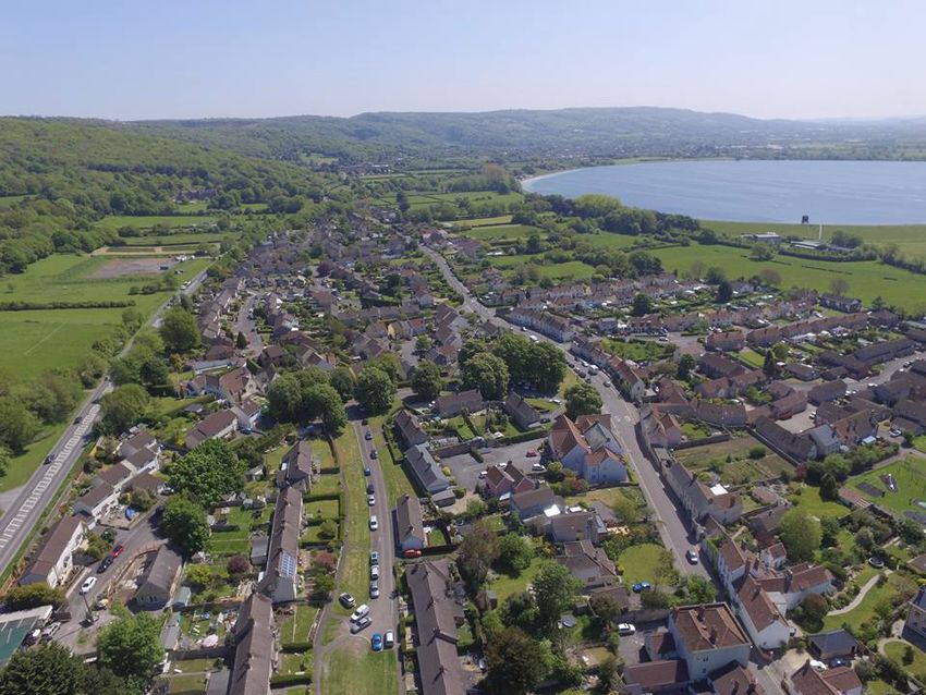
2.10. The Axbridge Pageant embodies and maintains a strong awareness of                         Axbridge Day 2018
         the town’s heritage and its enactment in The Square further highlights
         the unique value of the town’s architecture and layout. Axbridge is the
         only town in England that continues to hold a pageant.

     2.11. The sheer variety of activities and groups in the town reinforces many
         community connections. As well as weekly meetings for sports training
                                                                                                     Images     also including community garden allotments, picture of
         and xtures, various other societies and groups for all ages maintain a
         regular schedule of meetings5. In addition to the formal structures of                      dementia friends

         school, churches, town council, health centre and so on, Axbridge enjoys
         a rich expression of wider interests in theatre, cinema, music,
         photography, gardening, walking and other leisure pursuits. Axbridge
                                Archaeological and Local History Society meets
                                         regularly, and Axbridge District
                                              Museum Trust provides a popular
                                                  v e n u e f o r re s i d e n t s a n d            2.12. These events demonstrate the connectivity between the nature of
                                                     visitors alike in The National                    Axbridge’s community assets and their value to the life of the residents
                                                        Tr u s t ’ s K i n g J o h n ’ s               of the town. The ANP seeks to protect this relationship. The important
                                                              Hunting Lodge.                           locations used by the community are: The Square, The Furlong, the play
                                                                                                       area, the Jack Todd Memorial Garden, the Church of St John the Baptist,
                                                                                                       the Church Rooms, the Methodist church, the Town Hall, Hillside and
                                                                                                       Bailiff’s Wall allotments, the Community Allotment, The Roxy Cinema,
                                                                                                       The Lamb public house, the Oak House hotel, the Alms House cafe, local
                                                                                                       shops and Post Of ce, the Surgery, Old Railway Station, Axbridge First
                                                                                                       School, the town’s Conservation area and listed buildings, access to
                                                                                                       Cheddar Reservoir and the Sailing Club, Axbridge-Cheddar Cycle
                                                                                                       Walkway, the Strawberry Line, various footpaths reaching out into the
                                                                                                       surrounding countryside (see Plan of Community Assets on page 80).

                                                      5 See   https://axbridge-tc.gov.uk/calendar
                              Axbridge Day 2018

                                                                                                                                                                        PAGE 8
fi
            fi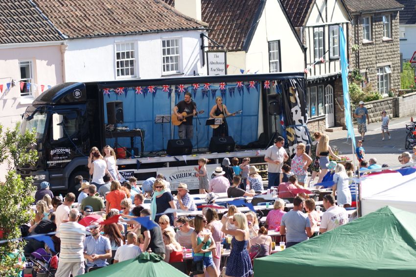
2.13. In addition to the rich community and cultural heritage expressed in
         the ANP community consultation, a number of recurring themes offer
         the potential to structure change and development whilst retaining and
         enhancing the feel and identity of Axbridge.

     2.14. These themes revolve around: affordability of housing, design style,   Vision for Axbridge
         traf c and road safety, employment and business generation and self-
         containment in the supply and transport of resources and resilience in
                                                                                  2.15. Axbridge is unique. It will need to respond positively
         the face of climate change and energy supply. The ANP weaves in these
         themes as a way to structure planning policy that is responsive to       to the Environment and Climate Change Emergency. The
         community need and the physical constraints of Axbridge itself.          town will need to accommodate sustainable housing and
                                                                                  employment growth. These challenges will be met by
                                                                                  ensuring that new developments meet sound sustainable
                                                                                  objectives whilst ensuring that opportunities for
                                                                                  appropriate housing and business, focussed on the needs
                                                                                  of the community are delivered. The vibrant community
                                                                                  spirit, historic background and local countryside, so
                                                                                  valued by its residents will be preserved and enhanced.

                                                                                                                                          PAGE 9
fi
CHAPTER 3
                                                                                                 ex local authority and privately owned housing. There are also a number
                                                                                                 of residential properties to the North of the A370 bypass. This variation
                                                                                                 of housing stock gives a diversity to the visual identity of the town.

             HOUSING AND DEVELOPMENT

             The Neighbourhood Plan Area

             3.1. Housing styles in Axbridge re ect its growth over the last few
                      centuries with over 938 households in total6. This includes examples of
                      Grade II listed properties directly fronting onto the street. Some are
                                                                                                         Furlong Place            Hippisley Drive              Furlong Place
                      situated in the medieval square at the heart of Axbridge, others radiate
                      outwards along High Street, West Street and St. Mary’s Street. They form
                      part of the designated conservation area (see map on page 75), along
                      with several old properties of character on Moorland Street.

              3.2. In other locations, there are detached properties set back from the road,
                      some of individual design. North of Cheddar Road several relatively
                                                                                                     Knightsone Close               Marron Close                Jubilee Road
                      modern brick-built cul-de-sacs offer a variety of house sizes. Orchard
                      Road, Knightstone Close, and Park eld Road embody a style of housing
                      that was originally developed as social housing. Houlgate Way contains
                      relatively modern properties, but with access to over 30 older apartment
                      households in St John’s Court, the conversion of the former workhouse
                      premises. Reads Garden, and adaptations of older premises off Penn
                      Way and Meadow Street show carefully designed examples of recent
                                                                                                     Old Church Road            Old Church Road               Park eld Road
                      in ll. These housing developments contain a mixture of local authority,

          6 Current   Town Council gure for newsletter distribution.

                                                                                                                                                                    PAGE 10
fi
     fi
                         fi
                                            fi
                                                 fl
3.3. Although Axbridge has a rich and AONB, consideration to potential impacts on
diverse architectural history the town sensitive landscape and wildlife sites is
recognises that future development, required7. Development potential is also
whilst honouring the visual identity of the affected by a Flood Zone immediately to the
town, must meet the need for suitable and south of the town8.
sustainable housing that bene ts its
residents and fosters a sense of community. Housing numbers
3.6. Sedgemoor’s Local Plan identi es the need for a
3.4. Despite the breadth of architectural styles and
High St minimum of 70 more dwellings in Axbridge outside of
streetscapes, there are key common aspects in terms of
settlement boundary. The 2016 Axbridge Town Council Housing
design and location that have been highlighted by consultation as
Needs Survey identi ed 28 respondents indicated a need to move within
being important to the community. These will have a positive impact in
Axbridge within 5 years but do not have the ability to purchase a
determining the future character of Axbridge and it is important that they
property outright. 17 of these respondents indicated a need for a one or
are re ected within any further development. These include:
two bedroomed property. In order to deliver a sustainable, mixed and
• the protection of green spaces; balanced community all housing development proposals for residential
development (both market and affordable) will be expected to provide a
• design that harmonises with the visual identity of Axbridge and its
suitable mix of different types and sizes of housing to meet the needs of
townscape;
the community, based on best evidence. This is also a requirement of the
• appropriate parking provision within any new development; Sedgemoor District Council Local Plan District Wide Policy D5. Details of
• the need for affordable homes; Axbridge Town Council’s Housing Needs Survey can be found at http://
www.axbridgeneighbourhoodplan.co.uk/wp-content/uploads/2019/11/
• ecological and sustainability issues both in design and function.
Infographic-Axbridge.pdf and Axbridge Town Council’s Affordable
3.5. These aspects of housing development need to be balanced against the needs Policy at https://axbridge-tc.gov.uk/wp-content/uploads/2020/06/
need to retain the unique visual historic character of Axbridge. In Appendix-D-Council-Policies.pdf (see Policy 3).
addition, with Axbridge being within the setting of the Mendips Hills
7 Axbridge Hill and Fry’s Hill are designated as Sites of Speci c Scienti c Interest (SSSI).
8 Strategic ood risk assessment is provided by Sedgemoor District Council.
PAGE 11
fl
fl
fi
fi
fi
fi
fi3.7. The Cheddar Road site (see appendix 8, page 75) in Axbridge has are aligned with the preferred zones for development identi ed through
outline planning permission for 20 properties (Planning Application public consultation in 2018. The sites identi ed through the Call for Sites
02/17/0002202). All these dwellings will be ‘affordable’ and are to be process have been assessed against set criteria.
built by Stonewater Housing Association. Sedgemoor District Council
3.11. The number of homes identi ed for Cheddar’s Yeo Valley site is outside
have agreed to make a contribution to the costs of this development to
of the Axbridge parish boundary (planning reference 17/18/00073
provide energy ef cient features that will make the dwellings more
identi es 100 new homes, with 15 being affordable). If planning
affordable to live in. Only 10 of the properties sit outside of the current
permission is granted this development will impact on Axbridge’s
settlement boundary and therefore count towards the 70 dwellings
infrastructure and amenities. This may include the school, doctor's
required in the Sedgemoor Local Plan.
surgery and, on a day-to-day basis, use of the post of ce, co-op and
3.8. Outline planning permission has been given for a site on Houlgate Way chemist . All would impact on road use and parking.
for a further 53 homes, 30% of which will be affordable (Planning
Application 02/16/00030). All 53 of these homes count towards the 70
dwellings required in the Sedgemoor Local Plan.
3.9 In ll development within the Axbridge Settlement Boundary is supported
where possible over development outside the Settlement Boundary.
However, it is recognised that more land outside and contiguous to the
Settlement Boundary will be needed to reach the minimum required
allocated housing numbers (70 homes). The preferred sites for
development have already been identi ed as zones (see Appendix 7).
3.10 Further to the public consultation in 2017 it was decided that a Call for
Sites was required to ensure that viable sites could be identi ed for
potential development. The Call for Sites in Axbridge conducted by the
ANP in 2018 has identi ed 4 additional sites offering a potential of 9 new
homes. Full details of these sites can be found in Appendix 4. These sites
PAGE 12
fi
fi
fi
fi
fi
fi
fi
fi
fi
fiPlanned development
3.12. In response to Sedgemoor’s Local Plan which
requires provision of a minimum of 70 homes, and
acknowledging current development expectations as
set out above, we have planned for the total provision
to be 72 homes over the life of the plan. We have
identi ed allocation as below:
Houlgate Way: 53 homes
Mendip View, Cheddar Road: 10 homes
Call for sites: 9 homes
Total: 72 homes
Please see map in Appendix 8, page 76, for an overview of all development sites.
PAGE 13
fiHousing and Development Aims and Objectives • Support small scale developments and in ll developments.
Aims: • Support retention and new development for retail and
commercial uses that meet a clear majority of the town’s policy
• Meet local housing, commercial and community needs in a way
criteria.
that ts with and enhances the character of the designated area.
• Ensure that any development of the town protects the natural and
historic environment and availability of green spaces within the Housing and Development Policies
designated parish boundary.
Policy HD-1:
• Maintain clear boundaries to protect the spatial integrity of the
town. Providing affordable homes to meet identi ed need
• Ensure new building and alteration meets high standards of Development proposals that provide affordable housing will be
sustainability in construction, materials and ongoing use. supported where they:
Objectives: • offer a range of tenures including social housing and shared
• Support the development of affordable housing, particularly for ownership
local and young people. • give priority for occupation to meet local needs and the needs of
• Ensure the provision of an appropriate mix of housing sizes, qualifying young people (see Appendix 3) particularly those who
property types and tenures. were born or grew up in Axbridge
• Support the use of contemporary and traditional design styles in • in accordance with the need identi ed by the most recent
the development of new homes provided they meet Axbridge Housing Needs Assessment (February 2016)
environmental and design standards as stated in ANP Town
Design Statement. See Appendix 1. • are part of a mix of different housing types
• Ensure energy ef ciency for new developments and that all new • support schemes which provide long-term affordability for eligible
housing achieves a very good EPC. households.
PAGE 14
fi
fi
fi
fi
fiJusti cation 3.15. The Axbridge Town Council Affordable Housing Policy (see Appendix
3) is designed to provide local people with the opportunity to secure an
3.13. The 2017 ANP survey, and the ANP Public consultation in 2018, showed
affordable home on future qualifying housing developments
a widespread acceptance of the need for affordable housing,
in Axbridge, and to prioritise lettings of current housing stock to local
particularly for local and young people, with the emphasis on targeted
people. The NPPF requires suf cient provision for affordable housing12.
provision for those with family here or if they were born or grew up
This is re ected in the affordable housing targets set out in the
h e re 9 . I n d e e d , t h e re a re s t ro n g f a m i l y t i e s t h at l i n k t h e
Sedgemoor Local Plan 13 and the housing needs assessments
Axbridge community.
undertaken by Sedgemoor and Axbridge Town Council14.
3.14. Axbridge is classi ed as a Tier Two Settlement in the adopted
Sedgemoor District Council 2011-32 Local Plan. Tier 2 settlements
(along with higher tier settlements) are expected to accommodate the
majority of the district's identi ed strategic housing growth
requirements. Axbridge is an expensive place to buy property with an
average price of £298K (October 2019)10. This exceeds the average of
£298,000 £231,000
£231K for homes in Sedgemoor as a whole11. This means housing
affordability is a major barrier for local people in terms of accessing a
suitable home. This is supported by the ndings of the 2011 census
identi es that the proportion of owner occupiers amongst those aged
Average price Average price
of a home of a home
16 to 49 has declined from 76% in 2001 to 64% in 2011 (See Appendix 5
in Axbridge in Sedgemoor
page 65).
9 http://www.axbridgeneighbourhoodplan.co.uk/wp-content/uploads/2017/11/Survey_analysis7.pdf.
10 Rightmove tells us that Axbridge has an overall average price of £298,200.
11 Average Sedgemoor house prices 2019.
12 NPPF Strategic Policy 20.
13 SDCLP Policy D6.
14 See Infographic link in Evidence Base.
PAGE 15
fi
fi
fl
fi
fi
fi
fias preferable for development and is in line with the National Planning
Policy HD-2: Policy Framework which places a value on small to medium sized sites16.
Residential development
3.17. ANP 2017 survey identi ed greatest support for small developments
Axbridge development proposals (further to the 72 dwellings
and individual plots containing a range of property types. 37% identi ed
identi ed*) for residential use will only be supported if they:
in ll as preferred for site selection. One large development was seen as
• make use of suitable vacant sites within the settlement boundary,
undesirable.
including brown eld sites or,
• are in the zones preferred in the public consultation, namely 3.18. The National Planning Policy Framework identi es that larger scale
designated zones 4 or 5 detailed in Appendix 7, and are either; developments or signi cant extensions to existing villages and towns
• to meet an identi ed local affordable housing need or local need to be ‘well located and designed and supported by the necessary
infrastructure priority (Local Plan policy T2b); or infrastructure and facilities18.
• are for small scale self-build or self-commissioned projects of no
3.19. In addition to public consultation, as a way of identifying suitable
more than 9 dwellings.
locations for development, a Call for Sites was conducted in 2018 as part
Elsewhere in the Parish residential development should be of the process of writing the Axbridge Neighbourhood Plan. The
appropriately controlled in accordance with the Countryside Policies in results identi ed 4 additional sites offering a potential of 9 new homes
the Local Plan.
(See Appendix 4). These sites are in-line with the preferred sites for
development as identi ed through public consultation.
Justi cation
*The 72 dwellings identi ed include:
3.16. The development of new housing in Axbridge is restricted by the
Houlgate Way: 53 homes
features of its geographical location. The development of in ll and small
Mendip View, Cheddar Road: 10 homes
sites can maintain the integrity of town boundaries and protect the
Call for sites: 9 homes
unique identity of Axbridge. This pattern of development also re ects
Total: 72 homes
the results of public consultation15. This identi ed smaller Zones 4 and 5
Please see map in Appendix 8, page 76, for an overview of all development sites.
15 See Question 13 & 14 in 2017 Survey.
16National Planning Policy Framework Paragraph 69.
17 See Sedgemoor Strategic Flood Risk Assessment.
18 National Planning Policy Framework Paragraph 20.
PAGE 16
fi
fi
fi
fi
fi
fi
fi
fi
fi
fi
fi
fi
fi
fl
fiimmediate setting, whilst being sensitive to the de ning characteristics
Policy HD-3:
of the local area.
Promoting good quality design
As set out in the Axbridge Town Design Statement development 3.21. It is important to enhance the visual identity of the town by making use
proposals will be supported if they: of the highest contemporary design and environmental standards that
pay attention to scale, form, materials, layout, landscaping, access and
• positively contribute to the distinctive setting and characteristics
of the town design to support energy ef ciency such as the retro tting of solar
panels. This will integrate new development with its surroundings and
• ensure the provision of an appropriate mix of housing sizes,
contribute to a sense of place for the community and visitors alike.
property types and tenures
• use designs which make homes more easily adaptable for lifetime 3.22. The aim of the Axbridge Town Design Statement is to promote high
use standards in the built environment (See Appendix 1). When assessing
• demonstrate high quality design and environmental standards. good quality design and environmental standards the Design Statement
This includes design which supports energy ef ciency and sets out the following principles in more detail.
resilience to climate change.
3.23. When assessing good quality design and environmental standards,
consideration will be given to developments that:
Justi cation
• will function well and add to the overall quality of the area
3.20. The environment of Axbridge is the most important factor in attracting • are visually attractive
people to live in the town. (See Question 6 in the 2017 ANP Survey
• are sympathetic to local character and history
http://www.axbridgeneighbourhoodplan.co.uk/wp-content/uploads/
2017/11/Survey_analysis7.pdf ). This is a response to the diversity of its • establish or maintain a strong sense of place
visual identity created through a breadth of housing styles. ANP 2017 • optimise the potential of the site
survey respondents identi ed the need for a good mix of housing and
• create places that are safe, inclusive and accessible
property types19. New development needs to signi cantly enhance its
19 See Question 7 in 2017 Survey.
PAGE 17
fi
fi
fi
fi
fi
fi
fitown, where many residential buildings also house business activity.
These are key areas of employment within the town. 26% of respondents
Policy HD-4
to the 2017 ANP survey identi ed as running a business or working from
Meeting community needs
home in Axbridge, either full time or occasionally22.
Development proposals will be supported where they:
3.26. The NPPF also approves well-designed new buildings to support
• take an integrated approach to housing and community facilities
expansion of business. In Axbridge this allows a focus to be placed on
• act to maintain and enhance local retail/commercial activity housing and development that allows/ encourages working from home,
• conserve and enhance access to the surrounding countryside remote working, live/work. The South West has the highest percentage
of employees working from home (9%) in the UK23.
• support provision or shared provision for occupants to work from
home 3.27. Axbridge is identi ed as a great place for the location or relocation of
• support provision for live/work development. businesses. ANP Local business questionnaire identi es a wealth of
small scale and specialist businesses already located in Axbridge,
attracted by lifestyle and community attributes. For details see http://
www.axbridgechamber.co.uk/business-directory/
Justi cation
3.24. This policy enables Axbridge to maintain and further develop its overall 3.38. Businesses support the development and sustainability of community
sustainability as a community with reference to the social and economic through engagement in and/or sponsorship of community events such
outcomes of town development. It aims to contribute towards the as the Blackberry Carnival, Christmas festivities, Axbridge Community
development of a lifetime neighbourhood20. Fun day and the pageant (every ten years). A strong town needs strong
local businesses to support a thriving local economy, create sustainable
3.25. The National Planning Policy Framework supports the sustainable jobs and economic prosperity. The Axbridge Chamber of Commerce
growth and expansion of all types of business in rural areas including has an essential role in achieving these aims. This is particularly relevant
the conversion of existing buildings21. This ts with the existing to further encourage and grow a strong sense of community and
commercial, retail, leisure and tourism pattern of employment within the prosperity for the town and its residents.
20 See 22 Question 16 in the 2017 ANP survey.
http://www.lifetimehomes.org.uk/pages/lifetime-homes-principles.html
21 The 23 TUC (2018) https://www.tuc.org.uk/news/growth-homeworking-has-stalled
National Planning Policy Framework Paragraph 83.
PAGE 18
fi
fi
fi
fi
fi3.29. Local businesses identify that in order to grow and harness the
potential for development in industry, support facilities, such as a local
work hub or a commercial shared work space, need to be available.
Support for this is seen in the ANP 2017 questionnaire with shared
workspaces, home working and agricultural employment seen as most 10% 10% OF PEOPLE IN
desirable in the development of businesses and local employment. ENGLAND & WALES
3.30. In Axbridge agriculture is an important part of local commercial
WORK FROM HOME
activity and is a desirable sector for employment development24. The
NPPF supports the development of housing for rural and farm workers
who need to live near to their place of work in the countryside25.
3.31. Over the last decade the South West has maintained its status as the
region of highest employment of the workforce in the UK (80.8%, 13% OF PEOPLE IN THE
October 2019) with a marked increase in working from home (18.7% in 13% SOUTH WEST WORK
2008 to 22.2% in 2018)26. In Axbridge, the ANP questionnaire of 2017 FROM HOME
shows 26.3% of respondents working full time or occasionally from
home27, and some local employment such as in servicing and sales
depends on travelling to different places with home as a base. Given the
town’s further heavy dependence on commuting to a workplace, long
term sustainability suggests meeting clear needs for local shared
workspace, working from home, or local of ces28. As of 2020 anecdotal
15% OF PEOPLE IN
evidence suggests that more people will be working from home. 15%
AXBRIDGE WORK
FROM HOME
24 Question 15 in the 2017 ANP survey.
25 NPPF Paragraph 79.
26 https://www.ons.gov.uk/employmentandlabourmarket/peopleinwork/employmentandemployeetypes
27 Question 16 2017 ANP Survey.
28 Question 17 2017 ANP Survey.
PAGE 19
fiCHAPTER 4
standards of a community. Many aspects of soft infrastructure have a
direct bearing on planning policy, but less obvious aspirations
must also be noted as a guide to future sustainable development.
COMMUNITY AND INFRASTRUCTURE 4.4. A guide to priorities can be found in ranking the main themes from a
Background to policies wide variety of questionnaire responses to what people felt would
contribute to community spirit:
4.1. Much of Axbridge’s infrastructure has developed over its long history.
Its geographical position, hemmed in between moorland and the
Mendip Hills, leaves little opportunity for expansion and change.
ACTIONS NEEDED RANK
However, this has resulted in a tight knit community that wishes to resist
Preserve/expand community 1
coalescence with its neighbours of Cross or Cheddar to retain the
activities
unique character and identity of the town29. Community hall/improve town hall 2
Improved communications 3
4.2. Appreciation of the community spirit of Axbridge was a highly
No/less parking in The Square 4
conspicuous element in the ANP community consultations with 96% of
respondents saying they particularly valued the community spirit of the More shops/eateries 5
town. Many went on to identify speci c features of the town’s Traf c calming/more lighting 6
infrastructure, facilities and activities which they felt could preserve and Inclusion for all 7
develop that sense of community30. These are explained in Chapter 2 of
Encourage small business 8
the ANP.
4.5. Axbridge Square is the centre and the hub of the town. It helps to
4.3. It is dif cult to articulate these features into an exact set of ingredients.
cement the community feeling and is a place where people meet. 99%
Some, such as Axbridge Square, have a clear physical reality – what can
of respondents felt that the Square made a contribution to the
be termed as hard infrastructure. Others fall into the less tangible
community spirit. In addition, 59% of respondents gave a medium or
category of soft infrastructure, which refers to all the institutions and
high priority to improving or expanding pubs/cafes/restaurants in the
activities that support the economic, health, social, and cultural
ANP 2017 Survey.
29 See ANP Survey questions 9, 14 and 30.
30 See ANP Survey question 20 & 21.
PAGE 20
fi
fi
fitown. Protecting commercial activity in the square and throughout the 4.8. Opportunities for the latter are limited, but signage could be improved,
parish is vitally important in maintaining this sense of community, and and the bypass is capable of adequately diverting all through traf c
also in attracting visitors to the town. away from the town centre. Current information is also limited on the
long-term capacity of the drainage, sewerage, energy supply and
4.6. The NPPF also emphasises the importance of supporting prosperous telecommunications systems. This is an issue of concern. The 2013-14
rural economies and aims to: winter oods left Axbridge Square and The Bank House under water and
• support sustainable rural tourism and leisure developments that required urgent upgrading of the culverts beneath The Square.
bene t businesses in rural areas, communities and visitors, and which
4.9. Likewise the long-term capacity of medical and school facilities must be
respect the character of the countryside.
analysed. Initiatives to identify any weaknesses in hard infrastructure
• promote the retention and development of local services and must be supported by developers and are recommended before any
community facilities, such as local shops, meeting places, sports signi cant development is permitted.
venues, cultural buildings, public houses and places of worship31.
4.10. The ANP recognises the importance of renewable and low carbon
4.7. Good quality new housing in appropriate locations within Axbridge will energy initiatives as the hard infrastructure of Axbridge is developed. It
be planned to take into account the soft infrastructure that supports a adopts the broad Local Plan vision on this issue32 and offers further local
strong sense of community coherence. It will also pay attention to any detail in Chapter 7, Aspirations and in Appendix 2. The policies below
negative pressure on the hard infrastructure of the town that new seek to ensure a high level of sustainability for the infrastructure of
development may bring. This includes issues such as: Axbridge and in so doing ensure a positive effect on the viability of its
• the need to improve narrow footpaths and generally enhance road community.
safety for pedestrians and cyclists in streets pre-dating motorised
traf c;
• the need to limit parking in The Square;
• improvements to the road system.
31 NPPF Supporting a prosperous rural economy, Paragraph 83.
32 SDCLP Living Sustainably, p.8.
PAGE 21
fi
fi
fi
fl
fiCommunity and Infrastructure Aims & Objectives Objectives:
• Preserve and enhance the sense of identity by limiting town
Aims:
expansion to prevent coalescence with either Cross or Cheddar.
• Ensure that infrastructure provision keeps pace with development • Prevent overloading of current drainage, sewerage and road
in the town. systems.
• Seek to enhance and protect local services, utilities and • Seek to protect and enhance the use of prioritised community
infrastructure to support local needs. assets including The Square, The Furlong, pubs and cafes, Farmers
• Protect and enhance the spaces, facilities and built environment Market, access to Cheddar Reservoir (See Plan of Community
which support a sense of community. Assets on page 80).
• Research and explore possibilities for enhancement and extension
• Protect the sense of the town’s identity by promoting its diverse
of community buildings and spaces.
mix of economic, cultural and social activity.
• Encourage and support agricultural and small-scale local business
initiatives within the parish.
• Measure, track, promote and act on the understanding and
development of the town’s hard infrastructure needs.
• Research and support sustainable local low carbon developments
such as local renewable energy, micro-grid schemes and the use
of solar panels.
Farmers Market Blackberry Carnival
Church of St John the Baptist Axbridge Day Boxing Day Hunt Axbridge Fun Day
PAGE 22Community and Infrastructure Policies levels will exacerbate the problems of traf c ow. The Square with its
limited parking suffers from the con icting demands of local and visiting
traf c.
Policy C&I-1:
Settlement Boundaries and Hard Infrastructure 4.12. Drainage and sewerage systems pose dif culties for development
because of their age and capacity. Wessex Water has con rmed that the
Development proposals will be supported where they:
sewers in Axbridge are mostly adequate, but there are a few under
• demonstrate no signi cant adverse impacts on drainage, sewerage, some strain. It also insists that new developments only connect ows
road infrastructure or that suitable mitigation measures are provided from kitchens, toilets and baths to the foul network. Surface water runoff
• preserve and enhance the distinctive self-contained character of the (e.g. rainfall) should not be connected to the foul system and instead
community , particularly its environment and community spirit drained using sustainable urban drainage systems (SUDS), so as not to
increase ood risk.
Axbridge CP
• protect the town’s identity, maintaining the green spaces eastwards
towards Cheddar and westwards towards Cross. Parish boundary, settlement boundary and ood risk zone
• avoid signi cant adverse impact on drainage, sewerage and
drainage, sewerage and road systems or that suitable mitigation
measures are in place. This should include the provision of a high
quality SUDS system where possible on individual application sites
and developments to meet any local policies in terms of discharge
rates
Justi cation
4.11. There are already clear natural constraints on the residential boundary
of Axbridge: ood plain to the south, the Mendip Hills AONB to the
north and parish boundaries to the east and west. The existing road
infrastructure is very narrow in a number of places and increasing traf c
Date Created: 20-5-2017 | Map Centre (Easting/Northing): 343252 / 154452 | Scale: 1:6500 | © Crown copyright and database right. All rights reserved (0100051834) 2017
Parish Boundary Settlement Boundary ANOB Flood Risk Zone
Farmers Market
PAGE 23
fi
fi
fl
fi
fl
fi
fl
fl
fi
fl
fi
fi
fl
fi4.14. We seek to preserve Green Buffers to the East and West of the Town
Policy C&I-2:
(See map below). The Green Buffers are small green areas intended to
Protecting utilities, infrastructure and community coherence
de ne the edges of Axbridge and to prevent development sprawl into
Development proposals will be supported where they:
neighbouring parishes. The areas have been selected with this single
purpose and there is no intention to try and restrict sustainable • Lead to a rate of growth which matches identi ed housing needs
development overall. The need for green spaces within the parish and and facilitates the integration of new residents into the community.
their possible designation will continue to be examined in the light of • Contribute to the enhancement or extension of the facilities
housing developments. Access to a network of high quality open spaces identi ed in our consultations as key to a strong sense of
and opportunities for sport and physical activity is important for the community, e.g. the Town Hall, The Square, The Furlong, The Church
health and well-being of communities33. NPPF states that planning Rooms (see 2.12 for a full list of community assets and facilities).
policies and decisions should protect and enhance public rights of way • Maintain or improve facilities for the wide variety of groups and
and access, including taking opportunities to provide better facilities for activities in the community which create sporting, leisure, artistic,
users. For example, by adding links to existing rights of way networks34. educational, and caring opportunities at all age levels.
• Demonstrate suf cient capacity in the school, doctors’ surgery,
Proposed green ‘buffer zone’ spaces
drainage, roads or any other service that is a concern of the town’s
residents, to accommodate the new development.
Where it has been identi ed by the relevant authority that
improvements are required to services and infrastructure, development
proposals will be supported where:
• They are implemented alongside the necessary improvements to
the infrastructure to support them.
Green spaces protecting the town’s identify between Axbridge and Cross/Cheddar
• Prior to occupation of a development site, the necessary
improvements should be completed.
33NPPF Paragraph 96.
34 NPPF Paragraph 98.
PAGE 24
fi
fi
fi
fi
fiJusti cation 4.18. Access to locations in the town may be adversely affected by
increased traf c caused by new housing development. Within the town
4.15. Axbridge First School Academy is already highly constrained for there are already many pinch points for traf c on narrow roads. The
classroom space. There have been frequent efforts to modify and adapt Square is subject to the competing demands of local parking, public
the structure of existing school buildings, with the inevitable use of transport and large delivery vehicles. A number of roads have
some portable cabin types of accommodation. The school would need pavements that are either too narrow or non-existent for safe
to move to a new location to cope with an increase in pupils and it is pedestrian use.
therefore important that building a new school is supported by the
town. School Governors have con rmed that there are no current plans 4.19. Increased housing in the town has the potential to outstrip the limited
for the school to move. facilities of community leisure, business and retail facilities within the
town.
4.16. The First School Academy playground space is almost entirely tarmac
and offers very limited scope for recreation and sports. The school eld
at the Furlong is available for such activities.
Policy C&I-3:
4.17. Axbridge Medical Practice has con rmed that its facilities and staf ng Economic resilience and sustainability of the community
are adequate for the current size of the community. They would expect Development proposals will be supported where they
increased funding for staff if their registered numbers increase, but • Allow for transition change of use from residential back to
there are clear logistical constraints on the size of the Axbridge surgery commercial.
and access to it. Parking within the present surgery site
• Enhance the image of Axbridge as a business location.
on Houlgate Way is very limited, leading to overspill on-street parking.
This effectively creates a single lane on Houlgate Way for what is both a • Increase self-containment, reduce the need to travel and are
bus route and a busy route for traf c in and out of the town. Future use accessible by sustainable transport .
of land near to the surgery must be carefully considered with regard to
these concerns.
PAGE 25
fi
fi
fi
fi
fi
fi
fi
fi4.21 48% of young people who live in Somerset live in rural areas35.
Although unemployment over the whole of Somerset is decreasing,
• Follow locally generated sustainability guidelines, for example as
Sedgemoor’s unemployment is higher than in other county districts, and
identi ed in the Sedgemoor Local Plan, on renewable energy,
youth unemployment gures (age 16 -24) remain higher than the county
energy ef ciency and sustainable transport, and where they
average36. The long-term sustainability of the town and its community
further support adaptation to climate change with regard to
depends on how many young people and families feel they can achieve
ooding, extreme weather, green infrastructure, and biodiversity.
an acceptable livelihood to continue living here.
• Demonstrate that signi cant adverse impact on current provision
of building use for commercial or retail activity is avoided, or that 4.22. Small to medium enterprises (SME’s) in total made up 99.9% of the
suitable mitigation measures are in place. total business stock within the district, with only 0.1% of businesses
employing over 250. Small Businesses (value less than £5m and employ
• Maintain or promote retail provision, especially in the Square and
less than 50 people) make up 98.6%, with the majority (76.5%)
High Street, that complements the existing retail provision and/or
employing less than 5 people. Retaining and enhancing local
promotes the unique town’s environment to visitors.
employment opportunities is critical in promoting greater self-
containment.
Justi cation 4.23. Sustainability of the community means both economic and now, all the
more urgently, environmental sustainability. Communities vary widely in
4.20. Space for outdoor sport is inadequate. The SLP Para 7.275 sets out the
their capacity to adapt to climate change and carbon reduction. It is
benchmark standards. For a community of 2,000 people the requirement is
therefore important to generate a speci c local response, which is
3.2 hectares available for outdoor sport. At present Axbridge’s only facilities
enlarged upon in Appendix 2. This contains for example, the
are The Furlong (area 2.28 ha) and the ve-a-side pitch at the Old Railway
requirements highlighted in the SDCLP ‘Living Sustainably’ Section 7
Station (area 0.042ha) leaving a shortfall of 0.878 ha. It is felt that provision
which emphasises the aspiration to engage fully in retro t strategies for
for outdoor sport should be made and believe that Zones 3, 4 and 5 present
all buildings in adapting to climate change37. This is important in
the best locations (see page 74 for map of Zones).
Axbridge where many older buildings are used for commercial and
business purposes.
35 See somersetintelligence.org.uk
36 See somersetintelligence.org.uk
37 SDCLP: Climate Change Adaptability. Section 7. 28.
PAGE 26
fl
fi
fi
fi
fi
fi
fi
fi
fi4.24. Axbridge is within the setting of the Mendip AONB and DEFRA's 4.25. The National Association of AONBs, supported by DEFRA, have an
Landscape Review Final Report highlights the need to keep objective to: Support the economic and social wellbeing of local
communities active and vibrant with good services and strong transport communities in ways which contribute to the conservation, and
links38. enhancement of natural beauty39.
38Chapter 3 of Defra's Landscape Review Final Report, Living in Landscape
39 See 2.6 Mendip Hills AONB and National Association for ANOBs shared objective.
PAGE 27CHAPTER 5
of charters and the town enjoyed grants of markets and fairs and
freedoms from tolls throughout the country. Its wealth was ultimately
based on the wool trade and a craft guild was founded. After the
medieval period the town declined, as it lay away from main roads and
HISTORIC AND NATURAL ENVIRONMENT never expanded beyond its medieval limits It is likely that the square
Background to policies market and the roads leading into it were developed between the C11
and the C13 when King John granted the town its charter. The site of the
5.1. Axbridge has a particularly
parish church of St John forms part of this plan The linear development
strong heritage that is linked to its
of West Street probably occurred as a suburb somewhat later - it was not
environment.
made part of Axbridge until the C17.
5.2. The history of Axbridge can be
5.4. Having prospered as a market town and local centre for the wool trade,
traced back to the reign of King
Axbridge acquired a Charter of Incorporation in 1557, though this was
Alfred when it was part of the
lost at the end of the 19th century due to inability to expand due to
Saxons’ defence system for Wessex
topographical reasons.
against the Vikings. The area was
inhabited during the Roman period
5.5. There are still some traces and indeed still present closes or lanes that
and, earlier still, by prehistoric man,
carry historic residential developments from the main St Mary street
whose int tools have been found
north to the church. These ancient lanes or closes are now either in lled
on the slopes of the local hills.
with Georgian cottages or their primary street facing accommodation
has grown thus closing off and engul ng the 14th century rows of
5.3. By the time of Domesday there was a mint, market and 32 burgesses. In
the C13 the town was granted a charter by King John when he sold the cottages into the main structure. Whilst there is much evidence of the re-
rest of the manor to the Bishop of Bath and Wells. In 1243 the town was facing of buildings in the late 18th and early 19th century, the heart of
represented as a borough by its own jury at the eyre. It is clear that the Axbridge has changed little and it retains a high percentage of listed
town enjoyed an autonomy largely unaffected by the Bishop, who buildings (90 in all), both in the Square and in terraces along the main
probably only held a few rents in the town. There were numerous grants streets.
PAGE 28
fl
fi
fi5.6. Axbridge has a designated Conservation area (1970, 1991) within the 5.10. Over recent years the intact historic core and attractive rural setting has
town. Its designation is due mainly to its collection of listed buildings attracted visitors with associated tourism activity and has helped to
that include The Square, Church of St. John the Baptist, King John’s develop a strong identity for the town.
Hunting Lodge, Axbridge Drug Store, The Court House, former
Axbridge workhouse, the Old Almshouse and St Michael’s Cheshire 5.11. The ANP seeks to protect and enhance the town’s distinctive built
Home amongst others. heritage and natural environment through alignment with both national
and local planning policy.
5.7. Conservation area status has afforded planning control over alterations
to existing buildings, and in the long term has safeguarded the area’s 5.12. The NPPF states that planning policies and decisions should contribute
character. to and enhance the natural and local environment40. Some of its
provisions are particularly relevant to Axbridge:
5.8. Residential development throughout the 20th century has encircled the
historic core. • protecting and enhancing valued landscapes, sites of biodiversity or
geological value
5.9. The town is surrounded by elds and hills. The Mendip Hills AONB lies to
• recognising the intrinsic character and beauty of the countryside, and
the immediate north of the town and Axbridge Hill, Shute Shelve Hill,
the wider bene ts from natural capital and ecosystem services
and Fry’s Hill are Sites of Special Scienti c Interest. They are a nationally
important botanical site, for both vascular and non-vascular plants. It • minimising impacts on and providing net gains for biodiversity
also contains a roosting site for two nationally rare species of bat and a • preventing new and existing development from contributing to
wide range of butter y species. To the south the levels stretch unacceptable levels of soil, air, water or noise pollution or land
to Weare and Brinscombe. Cheddar lies to the east; the Cheddar instability; and remediating and mitigating despoiled, degraded,
Reservoir and elds provide a much-needed buffer to separate derelict, contaminated and unstable land, where appropriate.
Axbridge from Cheddar.
40 NPPF paragraph 170.
PAGE 29
fi
fi
fl
fi
fi5.13. The NPPF further 5.16. Moving on to the historic environment, the NPPF states that heritage
emphasises that great assets such as sites and buildings of local historic value should be
weight should be given conserved “so that they can be enjoyed for their contribution to the
to conserving and quality of life of existing and future generations”43. It further emphasises:
enhancing landscape and
• the positive contribution that conservation of heritage assets can make
scenic beauty in Areas of
to sustainable communities including their economic vitality
Outstanding Natural Beauty41.
In addition DEFRA's 25 Year • the desirability of new development making a positive contribution to
Environment Plan states that planning local character and distinctiveness44.
authorities, can shape the way development
5.17. The NPPF places clear obligations on local planning authorities to
is used to contribute to their social, economic and environmental
support these and other provisions in heritage and environment. They
enhancement. While development is not prohibited in National Parks or
now appear as one of the strategic priorities of the Sedgemoor Local
AONBs, major development should take place only in exceptional
Plan:
circumstances42.
Enjoying and Achieving: To conserve and enhance the natural assets and
5.14. The National Association for AONBs have an objective to Conserve and
heritage of Sedgemoor including its natural resources, wildlife habitats,
enhance the natural and cultural heritage of the UK’s Areas of
landscape character and historic environment, including appropriate
Outstanding Natural Beauty, ensuring they can meet the challenges of
adaptation to climate change45.
the future.
5.18. This priority is ampli ed throughout Policies D19 Landscape, D20
5.15. The Mendip Hills AONB extends into the parish of Axbridge, therefore
Biodiversity and Geodiversity, D21 Ecological Networks and D22 Trees
conservation of the townscape directly impinges on the setting and
and Woodland46. Of particular importance to Axbridge is the further
scenic beauty of the AONB to the north.
policy on the Historic Environment, D2647.
44 NPPF paragraph 192.
41 NPPF paragraph 172.
45 SDCLP p.14.
42 DEFRA 25 Year Environment Plan page 57
46 SDCLP pp. 147-153.
43 NPPF paragraph 184. 47 SDCLP p.158.
PAGE 30
fiYou can also read