Flinders Island Structure Plan - Draft for Public Consultation July 2016 - 14.1.8 March 2021 - Flinders Council
←
→
Page content transcription
If your browser does not render page correctly, please read the page content below

14.1.8 March 2021

Flinders Island Structure Plan
Draft for Public Consultation
July 2016
14.1.8 March 2021

      Contents
      Executive Summary                                                                  3
      1.0 Introduction                                                                   5
      1.1 Background                                                                     6
               1.2 Regional Land use Strategy                                            7
                  1.3 Context                                                            8
                          1.3.1   Location
                          1.3.2   Population
                          1.3.3  Housing
                  1.4 Economy-Primary Production                                         9
                  1.5 Economy-Tourism                                                    9
                  1.6 Access                                                             10
                           1.6.1   Communications
                  1.7 Infrastructure                                                     11
                          1.7.1   Water Supply
                          1.7.2   Waste water
                          1.7.3   Hard waste
                          1.7.4  Energy
                          1.7.5  Road Network
                  1.8 Environmental Assets and Benefits                                  12
                      1.8.1    Scenic Quality
      2.0 What the Structure Plan Wants to achieve                                       14

      3.0 Land Use Principles                                                            15
      4.0 How will the desired outcomes be achieved?

                  4.1 Outcome 1 Primary Production Land is protected for future          16
                      pastoral use
                                                                                         22
                  4.2 Outcome 2 Population Growth through rural land diversification

                  4.3 Outcome 3 Contributing to nature based tourism                     26

              4.4 Outcome 4- Maintaining and enhancing liveability                       31
      5.0 Conclusion                                                                     37

Flinders Structure Plan            draft for consultation July2016                               Page 2 of 39
14.1.8 March 2021 Executive Summary The Structure Plan presented here for consideration and comment is designed to underpin a planning scheme for the Flinders Municipality. It seeks to satisfy the legislative requirement that planning policy is justified by strategic investigations and analysis. The investigations were conducted during 2015 and are contained in a Supporting Information Report. The Structure Plan has distilled the analysis into 4 strategic outcomes that can be achieved through spatial application and land use regulation with the aim of contributing to Council’s overarching goals to grow the population and diversify economic activity. The 4 strategic outcomes are to protect the core economy related to the grazing industry, to diversify rural land not required exclusively for grazing, to support nature based tourism potential and to maintain and enhance quality of life, commonly referred to as liveability. The document looks at each of these outcomes in turn and nominates land use planning practice methods for achieving them. Determining the 4 strategic outcomes was not a random act. Substantial investigations into a wide range of criteria were conducted and analysed and principles were developed to use in the decision making process. The principles are contained in section 3.0 of the document and feedback on them is encouraged. Principles for decision making are vital components of the process. They mean that it is clear how a decision is arrived at, that is, the resultant decision is in accord with the principles. This provides overall consistency and avoids ad hoc decisions, favouritism or whim. It also means that decision making is transparent. Once the principles are clear, it is apparent to everyone that an individual issue has been addressed within that context. The Structure Plan is presented for consultation with Appendices. This is largely for ease of download, since Appendices 1 and 3 are maps. Appendix 1 contains two maps. Map 1 shows the proposed Primary Production Areas: PP1 for the area to be protected for grazing purposes, PP2 the rural land to be diversified while maintaining the status quo in allotment sizes and the Blue Rocks precinct where uses have been expanded and lot sizes reduced as a method for facilitating economic activity in conjunction with residential development. Map 2 in Appendix 1 shows the land capability classifications for unreserved land on Flinders Island. Appendix 2 provides a table that elucidates in more detail how the strategic outcomes can be translated into planning policy. The table includes a description of particular areas (or in some cases individual allotments) and nominates the strategic intent for that particular site/location. It is important not to confuse the intent with a zone. No reference to zones is relevant to the Structure Plan. The Structure Plan sets out the land use strategy. At a later date, agreed land use strategy will become policy when it is matched with the purpose of an appropriate zone provided in the State Planning Scheme template. Trying to pre-empt a zone at this stage will be unhelpful and confusing. As well as identifying the intent for particular sites, Table 1 in Appendix 2 also includes a column where open space and public access linkages have been identified and another that lists the types of uses that could be appropriate for the site given its physical constraints. A final column describes the type of local provisions that may be needed in the planning scheme for development and use to comply with the principles for decision making and to be consistent with regional land use strategy and state policy (also requirements of the relevant legislation). Appendix 3 provides more maps that detail the proposed strategy for the settlements. Whitemark and Lady Barron have detailed township maps and also a map of their respective surrounds and how they may look if the 4 strategic outcomes are achieved. Appendix 4 provides the list of Heritage Places included in the 1994 (current) Flinders Planning Scheme. Feedback is sought on these and other heritage matters in discussion point 8.0. Throughout the document pink text boxes have been used to raise discussion points and seek feedback on specific matters. These matters are considered to be critical to understanding if the community concurs or not with the general directions set out in the document or to gather more information on things like public access Flinders Structure Plan draft for consultation July2016 Page 3 of 39
14.1.8 March 2021

or heritage places. Reference to the numbered questions in the pink text boxes will mean that submissions are
directed to key planning and/or legislative requirements. Submissions can of course also include other matters
that community members may wish to raise.

Section 1.0 of the document provides an Introduction and Background that will introduce the reader to the
process required by the Tasmanian Planning System, to the role of the Structure Plan and why this process is
still continuing after the draft Interim Planning Scheme was prepared in 2012. The remainder of section 1.0
provides a brief overview of broadly contextual information on Flinders Island.

Section 2.0 outlines the 4 strategic outcomes and the land use methods for achieving them. Section 3.0 lists
the 5 land use principles referred to above and asks the readers if they agree with the values inherent in each
of the principles.

Section 4.0 addresses each of the 4 strategic outcomes individually and provides commentary on how the
outcomes can be achieved and what that may involve. Various discussion points are raised throughout section
4.0.

Section 5.0 concludes the document and reminds the reader that adopting the 4 strategic outcomes set out
within the Structure Plan can contribute to the strategic goals of the Council. The goal to increase
development can seem to conflict with other goals such as preserving natural or scenic values, but the
investigations and analysis invested in this Structure Plan have proposed ways that both can co-exist. It
remains for the community to decide if they agree with the proposals within. If so, the translation into a policy
framework (the State Planning Scheme) will mean that an agreed way forward can be implemented through
the mandated regulatory system for land use planning in Tasmania.

Flinders Structure Plan          draft for consultation July2016                                       Page 4 of 39
14.1.8 March 2021
Introduction
The Flinders Municipality is a relatively remote local government area with unique characteristics and multiple
lifestyle advantages in conjunction with significant constraints related to economic productivity,
communications and access.
Historically reliant on an economy based on the pastoral and fishing industries, changes in recent decades
have seen the municipality recording a declining population over the last Census period. The direct
relationship between decline in population and decline in the economic viability of services presents a
strategic challenge.
It is known that economic productivity can be increased through population growth. Flinders Council has
identified population growth as a key tenet of the Flinders Strategic Plan 2015. Land use strategy is a subset of
Council’s strategic aims and thus focuses on supporting Council’s vision to grow the population as a means of
increasing economic activity.
Land use strategy results from research and analysis of the current economic, social and environmental
circumstances, the preferred outcomes that can be achieved through the Tasmanian planning system and the
opportunities and constraints that will facilitate and/or modify development goals. The research work is
1
contained in the ‘Supporting Information Report’ . The distillation of this research and analysis is presented
here as the Structure Plan for Flinders Island.
To assist in the goal of growing the population, the Structure Plan recognises the ‘out of the employment
market’ growth such as increasing the number of holiday houses to cater for increased visitors. The Structure
Plan also seeks to contribute to attracting a mixed demographic who can contribute to diversifying the
economy and growing the employment market. Population attractors for this market include:
family association with the place
lifestyle benefits (safety and security; community capital; public infrastructure)
intact biodiversity and broader environmental services
scenic quality of the coast and inland;
a range of possible land use patterns and uses.
At the same time, the primary production sector remains the key contributor to the productivity of the
Flinders Municipality and safeguarding pastoral activity is a key land use objective.
The circumstances affecting development in the Flinders Municipality are very different to elsewhere in
Tasmania and require a modified land use planning approach; notwithstanding the aim of the Tasmanian
2
Planning Scheme to achieve consistency across the state. The Regional Land Use Strategy acknowledges the
unique circumstances of the Furneaux Group and the need to accommodate that difference through local area
planning.
Local area planning is intended to be implemented through the municipal planning scheme. The municipal
planning scheme is derived from the Tasmanian Planning Scheme (the State scheme), i.e. the State determines
what zones and standards will be included in the State scheme and how the State scheme will be
administered; including how much provision will be made to include (or omit) local strategy.
Consequential to the preparation of the yet to be declared 2015 Tasmanian Planning Scheme, the Land Use
Planning and Approvals Act 1993 sets out in section 32 what a Local Provisions Schedule (LPS) of a (municipal)
1
Cox R 2015 Flinders Island Land Use Strategy Supporting Information( unpublished)
2
Northern Tasmania Development 2015 Regional Land use Strategy for Northern Tasmania
Flinders Structure Plan draft for consultation July2016 Page 5 of 3914.1.8 March 2021
planning scheme may contain. Sub section (3) establishes that “…subject to subsection (4), an LPS may, if
permitted to do so by the SPPs (State Planning Provisions), include a:
particular purpose zone
specific area plan
site specific qualification
Subsection (4) establishes a test for the incorporation of these local elements into the State scheme as follows:
“An LPS may only include a provision referred to in subsection (3) in relation to an area of land if-
a use or development to which the provision relates is of significant social, economic or
environmental benefit to the State, a region or a municipal area; or
the area of land has particular environmental, economic, social or spatial qualities that require
provisions that are unique to the area of land, to apply to the land in substitution for, or in addition
to, or modification of, the provisions of the SPPs”
The Structure Plan seeks to provide the basis and direction to satisfy this test. It is likely that most local area
provisions will rely on s32(4)(b).
Thus the Structure Plan has the key purpose of highlighting local land use priorities with the concurrent aim of
supporting a sustainable future for the Flinders Municipality.
The extent of this Structure Plan is Flinders Island. The outer islands are considered with Cape Barren Island
and subject of a separate Structure Plan to be prepared later in 2016.
The timeframe for the Flinders Island Structure Plan is ten years (to 2026) and some elements are proposed to
be staged to allow for review after 5 years permitting amendment to the planning scheme if required.
The Structure Plan sets out a synopsis of contextual information followed by an outline of the 4 land use
outcomes that have been identified as ways to contribute to Council’s intent to increase economic
productivity. Background material is contained in the Supporting Information Report. A Table is Appendix 2.
The table condenses the strategic intent of the 4 desired outcomes at allotment level.
The Structure Plan is the proposed strategy for land use on Flinders Island. To be implemented, the strategy
must be translated into the State planning policy framework which is the Tasmanian Planning Scheme. There
are legislative and policy limitations on what and how much local strategy can be translated. At present the
extent of these limitations is not entirely clear since the State scheme has yet to be finalised but obviously
any limitations can affect the achievement of the (local) strategic intent.
At this stage, Feedback is being sought on the local strategy (the Structure Plan). The draft strategy will
provide the basis for the zoning and other decisions made when trying to fit local objectives with the State
scheme template.
1.1 Background
The main drivers of the structure planning process are:
the State of Tasmania requirements pursuant to the Land Use Planning and Approvals Act 1993 and
subsequent amendments for a new Tasmanian Planning Scheme, and
Flinders Council’s strategic aim to build a sustainable population within the municipality.
Flinders Structure Plan draft for consultation July2016 Page 6 of 3914.1.8 March 2021
The structure planning process builds on the Flinders Land Use Strategy 2014 which incorporated community
responses to the draft Interim Planning Scheme 2012 and confirmed the Council’s general directions prior to
3
the preparation of the Flinders Council Strategic Plan 2015 . The structure planning process is also
underpinned by research and analysis conducted July- December 2015 and contained in the Supporting
Information Report.
In addition to investigating a range of topics including land suitability, natural hazards, demography, natural
resources management, scenic values, cultural values and infrastructure; the research also considered
consistency with State policy and the Regional Land Use Strategy for Northern Tasmania.
The structure planning process therefore encompasses regional planning principles as well as the connections
between the draft Interim Planning Scheme 2012 and the submissions received on that document. It also
considers the context provided by the Tasmanian Planning Scheme 2015. Land use research for Flinders local
government area identified the issues, constraints and opportunities relevant to the municipality. Analysis of
the research has distilled the strategic approach into condensed text and simple spatial representations on the
maps appended to this Structure Plan report.
What happened to the draft Flinders Interim Planning Scheme?
The draft Flinders Interim Scheme was exhibited for public consultation in May 2012. The Tasmanian
Planning System requires that a municipal scheme be substantiated by strategic documentation that
supports the decisions in the scheme and verifies consistency of the scheme with a range of State policies
regional strategies and other statutory requirements. The Strategic Planner was engaged in April 2014 to
conduct this work. The State election in March 2014 resulted in a new State government being elected with
an election commitment to repeal the Interim scheme framework and develop a new state-wide planning
scheme.
This commitment has been achieved; amendments to the legislation have repealed those sections of the
Land Use Planning and Approvals Act 1993 related to Interim Schemes and established provision for the
new State wide planning scheme. This was recently exhibited for consultation and is expected to be
finalised by the end of 2016. The new State scheme template has major differences with the State template
for the Interim Schemes in the zones and standards and codes within it. All this essentially means that the
draft Flinders Interim Scheme is not directly transferrable to the new State scheme, although some of the
intent of the Interim Scheme has been incorporated into the land use strategy and submissions made on
the draft Interim Scheme have also been considered in the strategy development.
1.2 Regional Land Use Strategy
The particular circumstances, strengths and preferences of the Flinders Municipality are acknowledged in the
Regional Land Use Strategy for Northern Tasmania (RLUS):
While the (Northern) region can generally be categorized into a settlement and activity centre hierarchy, this
system recognizes and responds to interactions that take place throughout the region that are not reflected in
the Furneaux Group. Due to the isolated function of the islands, the demands placed on settlement and activity
centres (and the relationship with lifestyle land use patterns) are different to the typical functions of other
levels of settlement. As such, planning for the islands and creation of demand to support economic objectives
4
for population retention (and) visitation are dependent on local strategy”.
In response to regional population changes, the RLUS concentrates growth within the Urban Growth Boundary
of existing settlements in order to preserve the region’s landscape, open spaces and productive agricultural
and rural lands. There is a commitment to preserve land for nature conservation and public recreation by
3
SED Consulting 2015 Strategic Plan Flinders Council
4
Northern Tasmanian Development. 2015. Regional Land Use Strategy for Northern Tasmania
Flinders Structure Plan draft for consultation July2016 Page 7 of 3914.1.8 March 2021
establishing a balance between urban and non-urban development by consolidating urban development
around existing services and by integrating urban transport networks. The Flinders Structure Plan is generally
consistent with this approach in that it proposes a tiered hierarchy building on existing settlements and seeks
to preserve productive land, biodiversity and public access and open space. Where Flinders deviates from the
RLUS and other local government areas, is in the scale of allotments, the absence of accompanying services
and infrastructure and the economic drivers for change.
1.3 Context
Location
The Furneaux Group of Islands consists of over 50 islands located between 39030’S and 40040’S. The largest
2 2
island in the group is Flinders Island (1333km ), followed by Cape Barren Island (82km ). The Furneaux Group
forms the greater part of the Flinders Municipality (with the Kent and Hogan groups forming the lesser part).
Population
From 2006 to 2011, the Furneaux Group population decreased by 82 people (9.6%) to 776 (and approximately
705 on Flinders Island). This represents an average annual population change of -1.99% per year over the
period. The downward trend has continued although the rate slowed in 2012. These figures include the
Aboriginal community of approximately 70 people living on Cape Barren Island. Anecdotal evidence is that
there were an additional 35 births on Flinders Island between 2012 and 2015. The data from the August 2016
Census is anticipated to show an improved outlook with regard to population trends.
The major differences between the age structure of the Furneaux Island Group and regional Tasmania are that
a larger percentage of persons are aged 55 to 59 (13.8% compared to 7.0%). There is a larger percentage of
persons aged 65 to 69 (8.8% compared to 5.5%), a smaller percentage of persons aged 15 to 19 (1.7%
5
compared to 6.7%) and a smaller percentage of persons aged 25 to 29 (2.2% compared to 5.1%).
The implications of this age structure require further analysis in the context of providing the workforce needed
to support economic activity. Similarly, gaining an in-depth understanding of the drivers of population change
will be important since the very low population data means that there are limits to the assumptions and thus
to the accuracy of modelling for population projections. Council’s Strategic Plan 2015 identifies understanding
these economic drivers as a priority project area.
A population target of 1200 persons by 2026 is taken as the benchmark for the land use planning process. This
represents an increase in the permanent population of approximately 500 people from the current level. While
this can be extrapolated along the lines of household size and available allotments to determine the amount
and type of land proposed to be made available into the next 10 year period, it must be recognised that the
Flinders Municipality is unlike most other local government areas.
The lack of population growth 2006-2011 and relative slow demand in the real estate market mean that the
usual technique for determining future land use, i.e. applying a demand to supply ratio, will be inadequate to
the task. Unique constraints related to location in Bass Strait, reliance on a single (pastoral) industry for the
economic base, communications impediments, comparative lack of infrastructure and services outside the
main townships, an aging population and important natural and cultural values must also be considered. This
emphasises the need for local provisions to be incorporated into the planning scheme so that implementation
of the scheme can achieve the strategic outcome of growing the population and increasing economic activity.
Housing
Housing on Flinders Island varies from soldier settler farmhouses scattered across the pastoral areas to
clusters of modern constructions taking advantage of stunning coastal locations such as West End and Palana.
5
ABS Census data 2006-2011
Flinders Structure Plan draft for consultation July2016 Page 8 of 3914.1.8 March 2021
Killiecrankie is a settlement with fishing and recreational antecedents and a mix of dwellings. Elsewhere, rural
small holdings provide a pattern of dispersed residential living in a rural or natural setting. Whitemark/Bluff
Road, Lady Barron and Emita support residential populations at higher density but still very low compared to
other municipalities.
Flinders Island is known to have a large proportion of absentee land holders, as indicated by the number of
unoccupied dwellings on census night; 379 were occupied on Census night in 2011 (down from 395 in 2006)
6
and 281 unoccupied (up from 220 in 2006).
Council records show that between October 2010 and April 2015 there were 48 dwellings approved on
Flinders Island. Comparison of the low population and the relatively high number of dwelling approvals
suggests that Flinders Island is attractive for holiday houses, an opportunity that can be further explored as a
potential economic driver and facilitated by providing rural residential opportunities .
1.4 Economy-Primary Production
Agriculture, in the form of the pastoral related activity is vital to the municipal economy. In 2010, ABS reported
a gross value of agricultural production on Flinders Island totalling $14 million. In 2008 there were 58
agricultural holdings running 119,159 head of sheep for meat and wool and 75 holdings running 20,032 head
of meat cattle. There was also 1,119 hectares of pasture for cereal or hay. Since then, there has been a
7
significant increase in the number of cattle and a reduction in sheep.
While there were 119 people working in the industry in 2006, it is expected that this number has decreased
concomitant to the increase in cattle and the consolidation of soldier settler farms.
The agricultural sector is nevertheless the main employment sector for the municipality. The agribusiness
associated with Markana Park in the north of the island was reported in 2014 to have 15 full time employees
8
with an expectation to substantially increase this number.
Even if projected increases in employment occur, it is unlikely that these will offset the population loss
associated with the trend to subsume smaller holdings into larger farms to ensure ongoing viability.
It is therefore important for the planning scheme to facilitate opportunities for diversification of the rural
economy. Flinders Island already produces garlic, olive oil, honey, chillies and wine as well as agricultural
products for the local market. Expansion of ‘niche market’ products and adding value to those products by
some form of processing is a critical element of the Council’s strategy to diversify the economy and is
considered to be a fundamental strategic pillar of the new planning scheme.
1.5 Economy- Tourism
The Flinders Municipality includes many spectacular tourism offerings based mainly on the natural
environment. While the sense of remoteness adds to the appeal, the cost of getting to Flinders Island is
generally regarded as an inhibiting factor. Most visitors arrive at Flinders Island Airport as passengers with the
commercial carrier Sharp Airlines which runs Metroliner aircraft (maximum capacity 19 people) from
Melbourne and Launceston.
6
ABS 2011 Census data
7
AK Consultants 2010 Agricultural Profile Flinders Municipality
8
ibid
Flinders Structure Plan draft for consultation July2016 Page 9 of 3914.1.8 March 2021
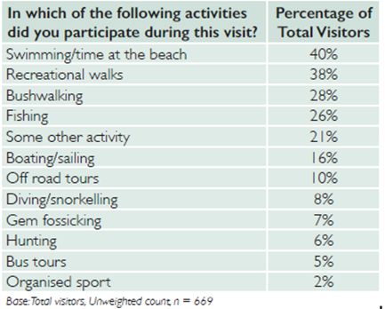
Tourism has the potential to contribute to the
diversification of the economic and employment base.
There are 4 main issues in relation to tourism 1) how to
facilitate broad distribution of benefits 2) how to
preserve the assets that attract tourism while delivering
appropriate tourism development 3) encouraging
tourists to stay longer- through establishment of a
variety of new accommodation/activities and 4) targeting
tourism ‘sub markets’ by providing more things to do e.g.
multi day walks, and ‘hero’ experiences, rock climbing,
mountain bike riding, culinary explorations
Figure 2 Visitor Activities
Opportunities for establishing small scale visitor accommodation and experiences should be available to all
islanders who wish to participate in the industry. This includes farm-stay accommodation. It is intended that
site and design criteria be incorporated as local area provisions where necessary to preserve the integrity of
the natural environment that is a key element of the Flinders Island visitor experience.
1.6 Access
Business operators, primary producers and the community in general are subject to a critical reliance on
transport connections. This is attributable to the location in Bass Strait and cannot be over emphasised. It is
exacerbated by the effect of weather and dependence on single operators for both flights and sea freight.
The additional costs of receiving and dispatching freight incur financial and operational implications for
business and development that are not experienced in other municipalities or sustained by mainland
competitors.
As mentioned above, there is one commercial airline service, Sharp Airlines, flying from Melbourne and
Launceston. Each fight accommodates a maximum of 19 people with a luggage allowance. In general, the
service to and from Launceston is twice daily except on weekends (once daily) and takes approximately 30
minutes. Sharp fly 3 times a week from and to Melbourne, more often during peak visitor times over summer.
In 2014-2015, the air movements through Flinders Island Airport totalled 19,454 passengers including private
and charter aircraft. The service is reliable and there is usually service capacity; both elements are critical to
the island economy. However the airfare is widely considered expensive by locals and visitors. The high fare
rate could limit investment growth and it has a social impact on island residents.
The Flinders Island airport has recently been subject to repairs on the runway. Further upgrading of the
runway may support the capacity to cater for larger planes, including for charter flights.
Council strategy is to consolidate air transport services at Flinders Island Airport. Growth in passenger
movements is anticipated to generate an increase in jobs of 8.1 by 2025 (7 direct and 1 indirect) and annual
regional income with increase by $0.505 million. This would mean that in 2025 visitors arriving by air will be
9
supporting a total of 25 jobs on Flinders Island. Through the collection of landing fees, this strategy will
broaden the contribution made by non- permanent residents and private visitors to airport operations. More
importantly it will mitigate the considerable biosecurity risk associated with private air strips.
9
Tourism Northern Tasmania 2016 Tourism Interim Infrastructure draft Final Report
Flinders Structure Plan draft for consultation July2016 Page 10 of 3914.1.8 March 2021 The development of a biosecurity strategy in collaboration with Biosecurity Tasmania and other stakeholders is planned for 2016-2017 and will (among other things), reflect the intention to reduce private landings. Communications Mobile and internet services on Flinders (and Cape Barren) Island are currently inadequate and improved communications technology will be critical to the Furneaux futures. Internet and mobile telecommunications services are received via an aging radio network that links Flinders Island to mainland Tasmania and then linked via a series of mobile towers and network sites. There is however, no more bandwidth or available backhaul to increase it. This situation means that frustratingly slow internet and mobile blackspots are commonplace. The broader implication is that residents cannot take advantage of the technologies and applications that elsewhere reduce the business costs, generate jobs and enable access to high quality education and health care services. A business case has been prepared for the Commonwealth’s Stronger Fund for a jointly funded project to install a multi bearer high capacity microwave IP radio link. In the meantime a new ‘Skymuster’ NBN satellite is expected to achieve some improvement and the community can now register with a provider for this service. 1.7 Infrastructure Water Supply Lady Barron has a good supply of water but most residents prefer on-site collection and storage of rainwater due to the tannin discolouration of the reticulated supply. This will soon be addressed by the new TasWater treatment plant which is expected to be in operation by the end of 2016. Reticulated water is supplied to Whitemark and parts of the Whitemark surrounds from the Pats River Reservoir. This supply is limited by the size of the reservoir and during the summer 2014-2015, water restrictions were instituted by TasWater to conserve supply. TasWater has commenced work on a treatment plant at Canns Hill which is anticipated to improve Whitemark town water to potable quality and to mitigate supply issues. This plant will be operational soon after the Lady Barron plant and will provide potable water to the Whitemark reticulated area. Elsewhere on Flinders Island, community and businesses rely on tank water collected on site for domestic and fire-fighting purposes. Waste Water There is no reticulated sewer system or sewage treatment facility on Flinders Island. Wastewater disposal managed on site with independent management systems, generally septic tank and soakage trench systems. All Flinders Island allotments are of a scale to manage such systems although coastal locations need to consider underlying bedrock that compromises absorption and the quality of runoff reaching the foreshore. Effective waste water disposal is an issue in Lady Barron due largely to the low permeability of the bedrock. Preliminary investigations into a staged reticulated service for the settlement have been ongoing for many years. It appears that neither Whitemark nor Lady Barron has the critical mass required to make reticulated services cost effective and continued monitoring of water quality will be required into the future. A Septic Tank Effluent Disposal Scheme (STEDS) or similar may eventually be appropriate near Whitemark since such schemes offer numerous benefits including less pollution of groundwater and surface water, Flinders Structure Plan draft for consultation July2016 Page 11 of 39
14.1.8 March 2021

dedicated reuse facilities and reduced costs for householders and businesses. Land in the vicinity of the
proposed water treatment plant Canns Hill may provide options for waste water treatment.

Hard Waste

Flinders Island relies on a landfill site on Memana Road approximately 6kms from Whitemark. Waste Transfer
stations are located at Killiecrankie and Lady Barron. Waste is sorted at the landfill site. At this time no waste is
disposed off island, although crushing and removal of car bodies could occur in the future. Three leachate
bores are sampled every 6 months to ensure water quality is maintained in the tributaries to the Pats River.

Environmentally responsible waste disposal is a major issue for small island communities. There are
opportunities to improve the waste management cycle especially for smaller recyclables such as printer
cartridges, batteries and the like. The possibility also exists of treating and adding value to putrescible and
green waste.

Energy

Hydro Tasmania is currently developing the $12.88 million Flinders Island Hybrid Energy Hub Project with the
aim of creating an off grid hybrid energy system capable of reducing, by approximately 60%, the amount of
diesel fuel currently used to create energy on the island. Comprising of a single 900kW wind generator, a
200kW array of solar photovoltaic panels and other hybrid components located on Thule Road, the project is
due for completion in late 2016.

There will remain parts of the island where self -sustainability in power supply is preferred by the land holder
due to the expense of extending existing power poles. There are also some locations, for example, NE River
and Boat Harbour where small scale energy technology should be encouraged in order to reduce the negative
impact on native vegetation ( through clearance for power lines) and on scenic values. Micro generation such
as roof mounted solar panels and small scale windmills that meet performance criteria should be encouraged
through local area provisions in the planning scheme, reflecting the current large uptake of private sector solar
generation for both power and hot water. Solar panels on holiday houses can also contribute surplus energy to
the grid even when unoccupied.

Road Network

Flinders Island road network is large relative to the population and the rates base. There is one major freight
route /arterial /State road (Lady Barron Road), stretching from Lady Barron to the Flinders Island Airport. Of
the estimated 400km of Council roads, approximately 100km is sealed.

Road maintenance consumes a large proportion of Council’s revenue and this should be considered in the
context of new development: land division and tourism in particular. Cost recovery models for future road
development will be necessary. There are also numerous anomalies in the status of various vehicle routes
which will need to be fully explored and resolved.

Including the main north- south Palana Road in the State infrastructure portfolio could free funds for
alternative use on other council roads and improve access to the northern part of the island beyond Emita.

1.8 Environmental Assets and Benefits
The scenic and recreational attractions of Flinders Island are largely based on the natural environment and are
highly valued by locals and visitors. Environmental services associated with the island’s natural assets: shelter,
food, water and climate modification, are also recognised as worthy of protection. Flinders Island supports
diverse ecological systems, threatened species and communities as well as geo-conservation sites of state and
national significance. Approximately 36913 hectares on Flinders Island is protected as National Park or other

Flinders Structure Plan            draft for consultation July2016                                       Page 12 of 39
14.1.8 March 2021

conservation area. There are also 10 land-holders supporting the reserve system through formal conservation
covenants; retaining and protecting native vegetation and habitats on their properties.

The lagoons of the east coast are significant habitat for waders and waterfowl. Logan Lagoon and eastern Cape
Barren Island wetlands are listed as RAMSAR sites for this reason. Fourteen migratory wader species are listed
under the Japan-Australia Migratory Birds Agreement and the China–Australia Migratory Birds Agreement.
Cameron Inlet is the only lagoon with permanent water during dry periods and is as important as Logan
Lagoon for feeding habitat for migratory waders. It is one of only 7 breeding sites in Tasmania for the rare fairy
tern.

While the vast majority of development occurs on private land, the Reserve system is integral to land use
planning in terms of recreational opportunities such as walking and cycling trails and public access to the coast.
Removal of native vegetation for primary production, development and associated regulatory requirements
(bushfire, roads) has implications for the corridors between reserves. The future effect of climate variability on
biodiversity is unknown and application of the Precautionary Principle is appropriate under the circumstances.

Scenic Quality

In addition to ecosystem services, the natural environment also contributes to sense of place and the Flinders
Island experience. Both, at least in part, relate to scenic quality. Scenic quality occurs regardless of land tenure.
It is a common resource and a key lifestyle and tourism attractor.

The Furneaux Islands exhibit outstanding landscape qualities established by natural granite outcrops,
vegetated hills, rocky coastlines, extensive lagoon systems and spectacular expanses of sandy beaches. The
absence of buildings and structures fosters a sense of remoteness and is a key attractor for nature based
appreciation and fundamental to local area character.

The strategic approach is to view these natural and scenic values at a landscape level and to integrate such
values with other strategic intentions such as infrastructure and tourism planning and the application of open
space contributions from approved subdivision. Considering scenic and natural values only at the level of
individual development applications risks ad hoc decision making that may not have a large impact at the
individual allotment level but which adds to incremental change. Development that incrementally degrades
scenic quality will diminish the island sense of place and obliterate the points of difference from other nature
based tourist destinations, extinguishing economic potential.

Visitors to Flinders Island in 2014-2015 rated activities based on nature as the most popular. Safeguarding the
natural assets (including scenic quality) of the island will also safeguard the attractions that underpin a
substantial segment of the municipal tourism economy.

Flinders Structure Plan            draft for consultation July2016                                       Page 13 of 39
14.1.8 March 2021
2.0 What the Structure Plan wants to achieve
The Structure Plan offers a platform for achieving strategic outcomes via the policy framework of the
Tasmanian Planning System. Key desired outcomes from Council’s Strategy 2015 that can be partially or wholly
achieved through land use planning on Flinders Island are:
1. Protecting primary production
2. Diversifying rural land
3. Contributing to nature based tourism
4. Maintaining and enhancing liveability
The strategic planning process has determined the planning practice methods by which land use planning can
contribute to these 4 key goals as summarised in the dot points below:
Protecting primary production
The Structure Plan seeks to protect land for future primary production by:
maintaining a pattern of large, connected allotments
retaining and enhancing environmental services provided by biodiversity
providing for clustering of associated uses within rural activity precincts
addressing commercial forestry and biosecurity
Diversifying rural land
The Structure Plan contributes to growing the population by:
diversifying rural land uses on land not required for primary production
facilitating a range of lot sizes
encouraging residential use in association with small business and product value adding
encouraging a clustering of dwellings within each locale connected where possible by a walking path
network and open space
Contributing to Nature Based Tourism
The Structure Plan supports nature based tourism destination by:
identifying land for visitor accommodation
integrating networks of walking, cycling and 4wd tracks
minimizing the impacts of development and use on the natural assets that underpin unique island
experiences.
Maintaining and enhancing liveability
The Structure Plan seeks to contribute to quality of life by:
employing principles of sustainable design and siting
establishing a public access network linked by private land to public open spaces and activities
integrating biodiversity into development decision making
managing and facilitating resilience to climate variability and natural hazard
Flinders Structure Plan draft for consultation July2016 Page 14 of 3914.1.8 March 2021
Discussion Point 1.0
Land use planning cannot by itself increase the population or improve economic activity. However, an
enabling environment can be facilitated by land use planning.
1.1 Would you like to comment on these four directions for land use?
1.2 Do you have any comments on the land use planning methods suggested in the dot points under
each of the 4 headings above?
3.0 Land Use Principles
The options proposed in the Structure Plan are underpinned by the following principles:
1. Retain and create public access and open space networks
2. Development and use satisfies joint public and private objectives
3. Cluster development at all scales to establish a land use pattern that maximises open space and
consolidates settlements
4. Consider the landscape level rather than only allotment level as a way of avoiding incremental attrition of
natural and scenic values
5. Identify and consider the long term implications of development
Discussion Point 2.0
Land use principles underpin consistent and transparent process. This means that when considering
how to achieve the desired outcomes in relation to primary production, growing the population,
tourism and liveability, the principles provide guidance in decision making, e.g. Will the decision
maximise public open space connections? Will it satisfy both private and public objectives? A decision
that achieves or contributes to the above will reinforce the values inherent in the 5 principles.
2.1 Do you agree with the values inherent in the land use principles?
2.2 Would you prefer other principles? If so what are they?
How will the desired outcomes be achieved?
Flinders Structure Plan draft for consultation July2016 Page 15 of 3914.1.8 March 2021
4.0 How will the desired outcomes be achieved?
4.1 Outcome 1 –Primary Production land is protected for future pastoral use
The Structure Plan framework seeks to contribute to the primary production sector by:
safeguarding primary production land in a two tiered approach
restricting commercial forestry
reinforcing biosecurity
retaining and enhancing environmental services provided by biodiversity
Safeguarding primary production land
Primary production on Flinders Island essentially involves pastoral activities. Farm gate values of production
are estimated to be in excess of $14 million, with pastures for animal production providing virtually all of the
Total Value of Agricultural Output.
Under the current planning scheme the majority of the island is zoned Rural. The scheme reflects an earlier
pattern of use. In the 22 years since the Flinders scheme was first declared, large patches of bushland have
regenerated where they were once (but no longer) grazed. In some locations screening belts of native
vegetation sown a decade or more ago have persisted and now provide valuable shelter for stock.
In 2010, AK consultants concluded that while there were 467 Property Identification Numbers( PIDs: which can
include more than one title) in the potentially available agricultural land in the Rural Zone, only 79 primary
10
producers in the municipality had an EVAO greater than $5000. EVAO is the estimated value of agricultural
operations. This conclusion supports the trend towards consolidation of smaller ‘soldier settler’ farms.
According to AK agricultural consultants the farm size for a “viable” business based on either sheep or cattle is
11
5,000-10,000 dse. The dse for Flinders Island on average is approximately 15dse per hectare. One 500
12
kilogram dry cow is taken to be the equivalent of 10 dse
Preserving allotments at a size that continues to facilitate viable primary production operations is a key aim of
the land use strategy. There are two areas where pastoral activity is currently the principal use and where
allotment size and connectivity is sufficient to support such activities: the east coast plains and the southern
coastal plain.
The Structure Plan proposes the east coast area as the Primary Production Area 1 which seeks to maintain the
existing large allotment size and restricts uses within the area to those essential to pastoral production.
The southern coastal plain is proposed as Primary Production Area 2 where the status quo is maintained in
relation to lot size but where the range uses is enlarged from resource development to include resource
13
processing. Parts of Lughrata, Killiecrankie, Palana and North East River are also proposed to be included in
Primary Production Area 2 with some locally specific provisions in relation to lot size, uses and land
management. Map 1 Primary Production is Appendix 1.
10
ibid
11
AK Consultants, 2010 Regional Summary of the Northern Tasmanian Municipalities
12
Pers. Comm. June 2016
13
Resource Development includes use for propagating, cultivating or harvesting plants and keeping & breeding of livestock & fish stock:
horse stud, intensive animal husbandry, controlled environment agriculture, cropping or turf growing. Resource Processing include
abattoir, animal saleyard, fish processing, brewery, distillery and other uses associated with treating, processing & packing plant or animal
resources.
Flinders Structure Plan draft for consultation July2016 Page 16 of 3914.1.8 March 2021
East Coast- Primary Production Area 1
Key characteristics of the east coast farming area include broad acre fenced paddocks interspersed in places
with shelter belts, gravel roads and widely spaced clusters of farm buildings.
The area is framed in the west by the vegetated slopes of the Darling Range and to the east, the complex
system of lagoons and dunes supporting an array of significant ecosystems and species. The land titles on the
eastern coastal plain are uniformly large and generally part of a cluster of similar titles forming holdings on
average approximately 650 hectares, although several holdings exceed 1600 hectares.
The subject area is shown on Map 1’Primary Production’ Appendix 1. The northern boundary is Five Mile Jim
Road (also including some Markana park allotments surrounded by Wingaroo Nature Reserve). The eastern
boundary is the reserved land of the east coast lagoons, the western boundary Fairhaven Road. The southern
boundary is north of Melrose Road from Emita Hall intersection to Kuhns Road and thereafter encompasses
both sides of Melrose Road. It includes all land north of Lady Barron Road extending in a straight line to Logan
Lagoon Road and all of ‘Thule’. Within these boundaries, pastoral activity is unfettered and farmers have
strong connectivity to adjoining primary production land.
The Structure Plan proposes that in Primary Production Area 1, subdivision less than 100 hectares may
potentially constrain future broad acre pastoral activity and therefore minimum allotment size should be
100ha.
The Structure Plan also proposes that in the Primary Production Area 1, uses should generally be limited to
those directly supporting primary production. More than one permanent dwelling per holding is not
supported. Excluding a dwelling, works or buildings (less than 200m in gross floor area), stockyards, and other
infrastructure that will enhance the primary production potential of the title/holding are facilitated and
14
Resource Development is proposed as permitted development excluding intensive animal husbandry
(discretionary) and plantation forestry (prohibited).
Farm-stay visitor accommodation may be an option where existing residential buildings are surplus to
permanent residential requirements. Visitor accommodation in existing buildings should not be converted to
dwellings.
There are some existing smaller allotments up to 40ha in individual ownership where a wider variety of uses
may be appropriate if such uses are compatible with the primary production on adjacent allotments. In
addition, there are a few localities where activities supporting the primary production sector already occur
within the proposed boundary of Primary Production Area 1. These smaller allotments and existing activity
precincts could be a focus for activities that support primary production but do not need to be on farm.
Affiliated uses that are encouraged to set up in activity precincts include; mechanical repairs, storage and
logistics, transport, plant and machinery depots, abattoir, resource processing and manufacturing and
processing. It is proposed that these uses will be facilitated with a permitted pathway where they are to occur
in the identified precincts as shown on Map 1 ‘Structure Plan’ Appendix 3 although it is likely that this strategy
will need to rely on a local provision. Clustering future activities to develop precincts over time is designed to
retain the maximum amount of primary production land, in the Production Area 1 for the main purpose of
pastoral production.
14
Resource development includes propagating, cultivating or harvesting plants and keeping & breeding of livestock& fish stock: horse
stud, controlled environment agriculture, cropping or turf growing but excluding intensive animal husbandry as anything other than
discretionary use.
Flinders Structure Plan draft for consultation July2016 Page 17 of 3914.1.8 March 2021
Definitions
Resource development includes use for propagating, cultivating or harvesting plants and keeping & breeding
of livestock& fish stock: horse stud, intensive animal husbandry, controlled environment agriculture, cropping
or turf growing.
Resource processing include abattoir, animal saleyard, fish processing, brewery, distillery and other uses
associated with treating, processing & packing plant or animal resources.
Manufacturing and Processing is use of land for manufacturing, assembling or processing products other than
Resource Processing. Examples include boat building, brick making, cement works, furniture making, glass
manufacturing, metal and wood fabrication, mineral processing and textile manufacturing.
Discussion Point 3.0
3.1 Do you agree with the proposed boundary for Primary Production Area 1? If not, please
provide your reasons.
3.2 Do you agree with the minimum allotment size in Primary Production Area 1? If not,
please say why.
3.3 Do you have a comment on the range of uses proposed in Primary Production Area 1?
3.4 Do you think the idea to cluster related activities off farm in Activity Precincts is feasible?
Southern Plain- Primary Production Area 2
The southern coastal plain comprises many titles that are smaller than those on the eastern coast but are
nevertheless on average100 hectares or more. Despite the large lot size, this locality has a different character
to the broad acre character of the east coast.
The character is at least in part derived from the undulating topography and patches of M. ericifolia; the
remnant swamp paperbarks which enhance the landscape and provide a more sheltered character. These
remnant patches also contribute to the open space network as habitat corridors and help to provide
environmental services in relation to soil microbia and to water table and salinity management.
The relatively larger number of owners is not considered to fetter pastoral activities and may provide
opportunities for expansion of viable farms. The subject area is shown on Map 1. Appendix 1 It is south of
Lady Barron Road, extending to the coast at Petrifaction Bay, to the eastern side of the Strzelecki National Park
and west of Trousers Point Road as far as Whitemark. The map also shows that parts of Lughrata, Killiecrankie,
Palana and North East River are also proposed to be included in Primary Production Area 2. In these latter
locations, locally specific provisions are proposed in relation to lot size and land management. The Table that is
Appendix 2 provides guidance on local provisions and exclusions in these locations.
The Structure Plan proposes that in Primary Production Area 2, Resource Development ( other than plantation
forestry and intensive animal keeping) will be a no permit required use and a broader range of rural based
activities will be ‘permitted’ uses including Resource Processing and Manufacturing and Processing. It is
Flinders Structure Plan draft for consultation July2016 Page 18 of 3914.1.8 March 2021
envisaged that a further range of uses be listed with a discretionary pathway, for example, extractive industry,
storage, food services and tourist operation where such operations do not impact on the primary purpose of
the land. More than one permanent dwelling per title is not supported and residential use for a single dwelling
is expected to be discretionary, as is visitor accommodation, although alterations to existing dwellings and
15
visitor accommodation within an existing building is recommended as a ‘permitted’ use .
The minimum allotment size in Primary Production Area 2 is proposed to retain the status quo at 40 hectares
and subdivision less than this is not supported, unless for excision of an existing dwelling or visitor
accommodation if the balance lot can still provide for resource development use. Subdivision will consider
remnant vegetation and configure subdivision boundaries to retain remnant patches on the one title. In the
north western sections of the Primary Production Area 2, the allotment size is proposed to be subject to a
locally specific qualification (see Appendix 2). Minimum allotment size in the Primary Production Area 2 is
nominated as a topic for the mandated 5 yearly review of the scheme.
Discussion Point 4.0
4.1 Do you agree with the proposed boundary for Primary Production Area 2? If not,
please provide your reasons.
4.2 Do you agree with the minimum allotment size of 40ha in Primary Production Area
2? If not, please say why?
4.3 What are your thoughts on the range of uses proposed for Primary Production
Area 2?
see definitions previous page
4.4 Do you agree with Resource Processing uses ( ) as ‘no permit
required’?
Plantation Forestry
Plantation forestry means the use of land for planting, management and harvesting of trees for
commercial wood production, but does not include the milling or processing of timber, or the planting or
management of areas of a farm for shelter belts, firewood, erosion or salinity control or other
environmental management purposes or other activity directly associated with and subservient to
another form of agricultural use.
Previous plantation forestry on Flinders Island has left a legacy of un-rehabilitated land with ongoing
environmental impacts including contamination of adjoining bushland by weed pinus radiata and increased
fire hazard.
It is now known that plantation forestry affects water tables, provides minimal employment opportunities and
ties up land for long periods of time, restricting other uses. The intention is that rural land should be sterilised
from plantation forestry activities and zone specific qualifications may be required to exclude plantation
forestry operations.
Approximately 275 hectares at North East River and approximately 20 hectares at Lady Barron require
rehabilitation and to address the issue of seedlings contaminating adjacent native bushland. This land is
unlikely to be suitable for primary production without significant expense that is likely to outweigh potential
15
Minor alterations that do not enlarge or extend are exempt.
Flinders Structure Plan draft for consultation July2016 Page 19 of 3914.1.8 March 2021 benefits of grazing. Tourist operations and residential living at very low density may be a possibility in the North East River locality. Resource Development, Resource Processing may also be appropriate if performance criteria related to scenic amenity and stormwater can be achieved. The site at Lady Barron lends itself to a collaborative project to rehabilitate the land for integration into adjacent bushland. Biosecurity Biosecurity is an important strategic issue given the location of Flinders Island midway between the mainland and the rest of Tasmania. DPIPWE are preparing a biosecurity strategy for the municipality. The land use policy framework can contribute to biosecurity by strategically considering the use of open space as buffer between the spread of weeds from garden ‘escapes’ and by removing private airfields from the uses envisaged in the relevant zone. Airfields that are formally recognised for passenger landing, two at Lady Barron and the main Flinders Island Airport are proposed to be the only landing strips with existing use rights in the new planning scheme. This may require a local provision in the scheme. Biodiversity While not an issue that can be easily addressed in a planning scheme the retention of native vegetation on rural land, especially remnant patches of M. ericifolia, is an important issue related to preserving open space connectivity, biodiversity and environmental services (for example, shelter, erosion control and management of the water table). The Structure Plan identifies areas on primary production land where remnant threatened vegetation communities are scattered in sufficiently sized patches to be useful in providing environmental services related to modifying localised climatic conditions, biodiversity and groundwater. There are important threatened vegetation communities in the Ranga area in particular north of Lady Barron Road either side of Thule Road and either side of Coast Road, also in the vicinity of the Samphire River and in the area south of Whitemark to Trousers Point Road. Open Space linkages with large vegetation patches on Crown land, on Local Authority land adjacent to the Lady Barron Waste Transfer station and on Vinegar Hill are also important. Further north, threatened species are mapped at very high density on several individual allotments at Long Point Centre Hill and Killiecrankie. Threatened ecological communities occur in large patches at NE River; east of Palana Road near West End Road intersection; at Leeka and West End; along Boat Harbour Creek ; adjacent to Killiecrankie, Limestone and Marshall Bays; north of the Dock; on Quoin Hill and at NE River. A precautionary approach in these remnant areas in relation to further clearance and/or destruction through access to cattle is encouraged. The as yet unknown effects of predicted climate variability on the ecological communities that contribute to the island’s environmental services, reinforces this approach. In general, further study including the potential impacts of climate variability on existing vegetation and the water table are encouraged. Monitoring salinity in test wells is supported in order to better understand this issue and to contribute to ongoing protection of rural productivity. Establishing links with NRM North may provide property managers with enhanced opportunities to link to information sources, regional programs and funding to protect and enhance environmental services on their land. The Natural Assets Code is included in the State planning scheme with the purpose of (among other things), protecting threatened native vegetation communities and threatened flora species. At time of writing, the Code is likely to be subject to significant attention during the hearings process for the new State scheme and may be subsequently amended. It is worth noting that the Code does not apply to use and this seems unlikely to change. Flinders Structure Plan draft for consultation July2016 Page 20 of 39
You can also read