Combating Land Degradation and Desertification: The Land-Use Planning Quandary - MDPI
←
→
Page content transcription
If your browser does not render page correctly, please read the page content below
land
Article
Combating Land Degradation and Desertification:
The Land-Use Planning Quandary
Helen Briassoulis
    Department of Geography, University of the Aegean, 81100 Lesvos, Greece; e.briassouli@aegean.gr;
    Tel.: +30-225-103-6411

    Received: 15 December 2018; Accepted: 28 January 2019; Published: 1 February 2019

    Abstract: Land-use planning (LUP), an instrument of land governance, is often employed to protect
    land and humans against natural and human-induced hazards, strengthen the resilience of land
    systems, and secure their sustainability. The United Nations Convention to Combat Desertification
    (UNCCD) underlines the critical role of appropriate local action to address the global threat of land
    degradation and desertification (LDD) and calls for the use of local and regional LUP to combat
    LDD and achieve land degradation neutrality. The paper explores the challenges of putting this
    call into practice. After presenting desertification and the pertinent institutional context, the paper
    examines whether and how LDD concerns enter the stages of the LUP process and the issues arising
    at each stage. LDD problem complexity, the prevailing mode of governance, and the planning style
    endorsed, combined with LDD awareness, knowledge and perception, value priorities, geographic
    particularities and historical circumstances, underlie the main challenges confronting LUP; namely,
    adequate representation of LDD at each stage of LUP, conflict resolution between LDD-related and
    development goals, need for cooperation, collaboration and coordination of numerous and diverse
    actors, sectors, institutions and policy domains from multiple spatial/organizational levels and
    uncertainty regarding present and future environmental and socio-economic change. In order to
    realize the integrative potential of LUP and foster its effectiveness in combating LDD at the local
    and regional levels, the provision of an enabling, higher-level institutional environment should
    be prioritized to support phronetic-strategic integrated LUP at lower levels, which future research
    should explore theoretically, methodologically and empirically.

    Keywords: integrated land-use planning; land degradation; desertification; policy; phronetic approach

1. Introduction
     Land1 mediates all interactions between the natural environment, society and the economy [2,3].
Land resources provide ecosystem services but also pose constraints on human activity which, if violated,
generate important unwanted environmental and socio-economic consequences. The alarming pace
at which land resources are degrading in recent times has been recognized at the international and
subglobal levels [4–7]. Sustainable Development Goal (SDG) 15, one of the 17 SDGs decided at the Rio+20
conference in 2012, is specifically geared to “protect, restore and promote sustainable use of terrestrial
ecosystems, sustainably manage forests, combat desertification, and halt and reverse land degradation
and halt biodiversity loss” [8].

1     “Land means the terrestrial bio-productive system that comprises soil, vegetation, other biota, and the ecological and
      hydrological processes that operate within the system” [1].

Land 2019, 8, 27; doi:10.3390/land8020027                                                     www.mdpi.com/journal/land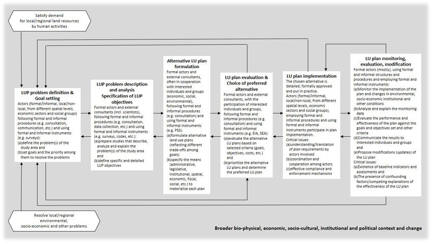
Land 2019, 8, 27                                                                                                         2 of 26

      The wise governance of land resources in coupled human-environment systems, or land systems2 ,
is key to strengthening their resilience against natural hazards and numerous other environmental,
technological and socio-economic disturbances [10–13]. ‘Land systems science’ is a term coined to
denote the contemporary, interdisciplinary scientific domain concerned with the theories, approaches,
analytical tools and instruments related to the analysis and resolution of land-use problems [12,14].
Land-use planning (LUP) is an instrument of land governance that has been used since ancient times
to protect land and humans against natural hazards and to address pertinent land use-related issues in
order to secure the sustainability of land systems [15–19].
      Desertification, an extreme form of natural and human-induced land degradation, and drought,
a natural hazard, threaten the smooth functioning of land systems [7]. Desertification differs from other
natural hazards, such as fires, floods and earthquakes, because it is a wide-net, higher level, multi-scalar
and long-term phenomenon; at the local level, it is mostly experienced as (severe) land degradation.
Land degradation and desertification (LDD) is the term commonly used in official (e.g., UN, European
Union) and scientific quarters, and which is adopted in this paper. The causes and consequences of LDD
concern several interdependent human activities, directly implicate more than one land resources (soil,
water and vegetation) and involve diverse economic sectors, social groups and institutions, spanning
the local to global spectrum. The incidence of LDD exposes land resources and human populations
to multiple threats: loss of land productivity, food insecurity, water shortages and scarcity, economic
hardship, social deprivation and health risks [20–25].
      The signing of the United Nations Convention to Combat Desertification (UNCCD), one of the
three Rio Multilateral Environmental Agreements (or, Conventions)3 , in 19944 underlines the global
significance of the phenomenon as well as the critical role of appropriate local action. Since 2012,
the UNCCD has embraced SDG 15 and, more specifically, Target 15.3 that sets the ambitious goal
to achieve land degradation neutrality (LDN) by 2030. Among the several actions for its effective
implementation, the UNCCD and other international and sub-global organizations incite the signatory
parties to use local and regional land use planning to help combat desertification and mitigate the
negative effects of drought in affected areas [26] and, more recently, to address the LDN target5 [27].
Putting this straightforward call into practice, however, presents considerable challenges, several of
which have been noted since the early days of the UNCCD [28].
      In complex land systems, a multitude of actors interacting on and across scales continuously place
diverse demands on a multitude of interconnected resources to satisfy various, often conflicting, goals,
environmental protection being one of them, that differ in priority among groups [13,29]. Conflicts
arise over the allocation of land among competing uses which accrue short- and long-term costs
and benefits to individuals and groups. If human activities locate in resource-poor (e.g., water),
hazard-prone and other high-risk areas, biophysical constraints imply high costs of protection or,
if they are ignored, significant environmental and socio-economic costs result. LUP aims to arbitrate
and resolve these conflicts and issues to secure the sustainability of local and regional development [30].
In LDD-prone areas, in particular, the LDN goal makes LUP an inevitable instrument in the fight
against LDD. This is a demanding undertaking because LUP is called to harmonize the LDN with
numerous other goals and it is, furthermore, complicated by the ever-present uncertainty regarding
future human needs, goals and priorities, environmental conditions, socio-economic and technological

2   “Land systems constitute complex, adaptive social-ecological systems (Berkes et al., 1998) shaped by interactions between
    (i) the different actors and demands that act upon land, (ii) the technologies, institutions, and cultural practices through
    which societies shape land use, and (iii) feedbacks between land use and environmental dynamics (Millennium Ecosystem
    Assessment (MA), 2003; Verburg et al., 2015).” [9], (p. 53).
3   The other two are the ‘sister’ Conventions of the UNCCD, the UNCBD (United Nations Convention for Biodiversity
    Conservation) and the UNFCCC (United Nations Framework Convention for Climate Change).
4   The UNCCD came into force in December 1996.
5   “Furthermore, through Decision 2/COP.12, the UNCCD endorsed the formulation, revision and implementation of action
    programmes in view of the 2030 Agenda for Sustainable Development, (United Nations General Assembly, 2015) encouraging
    the linkage between planning and the implementation of LDN” [27], (p. 76).
Land 2019, 8, 27 3 of 26
change, unpredictable events and their changing constellations. Harmonization points to the need
to apply phronesis (practical wisdom) [31] in making land-use decisions to safeguard the potential
of affected areas to successfully adapt to changing conditions and, thus, secure their resilience and
enhance their sustainable development prospects.
This paper delves into this land-use planning quandary aiming to show that LUP is not a straightforward
but a complex endeavor, reveal the LUP challenges facing the fight against LDD and suggest avenues
to handle them to foster the effectiveness of LUP efforts. The discussion is general applying to most
(democratic) socio-political contexts although geographic particularities and historical circumstances
determine the actual form the issues and challenges obtain. The second section briefly presents the
main features of desertification and the institutional context to combat it. The third section introduces
land-use change and land-use planning and explores the issues and challenges arising at each stage
of the LUP process in the context of combating LDD at the local and regional levels. The concluding
section suggests necessary priority actions to realize the integrative potential of LUP and, thus, improve
its effectiveness in combating LDD that indicate future research directions.
2. Desertification and the Institutional Context to Combat Desertification
2.1. Desertification
Desertification has received and, with the escalation of global warming, is receiving significant
political support at the international and subglobal levels [4,6,7,22]. However, it remains a politically
contentious issue; the existence of more 100 definitions is telling [32]. The UNCCD definition, which is
mostly used by now, states that desertification is “land degradation in arid, semiarid and subhumid
tropics caused by a combination of climatic factors and human activities” [1]. Land degradation
means reduction or loss of the biological or economic productivity and complexity of rainfed cropland,
irrigated cropland, or range, pasture, forest and woodlands resulting from land uses or from a process
or combination of processes, including those arising from human activities and habitation patterns,
such as: (a) soil erosion caused by wind and/or water, (b) deterioration of the physical, chemical,
biological and economic properties of soils and (c) long-term loss of natural vegetation [1,23].
This definition makes clear that (a) desertification is land degradation in the drylands6 , i.e., in areas
with adverse biophysical conditions, (b) it leads to an extreme, often irreversible, state of degradation
implying reduction or loss of both biological and economic productivity and complexity of land, (c) the
natural resources concerned are climate, soil, water and vegetation, (d) it involves both natural and
human-induced processes operating at multiple spatial and temporal scales, and (e) a variety of human
activities and users of land are implicated.
Biophysical and human driving forces (indirect drivers), from the local to the global levels, underlie
the proximate causes (direct drivers) of LDD; i.e., human activities, such as agriculture, animal husbandry,
forestry, housing, tourism, transport, extraction and energy production. The associated land-using and
potentially resource-degrading practices include intensive cultivation, monocultures, abandonment
of traditional practices (e.g., terracing), poor or no maintenance of rural holdings, overgrazing,
deforestation, forest fires, water overdrafts, extraction, drainage of wetlands, and large infrastructure
works [4,5,22–24,33–36]. Their combined action modifies land resources and produces land use and
land cover change which, under adverse biophysical conditions, set in motion processes of LDD.
The biophysical drivers of desertification include climate, geology, soil conditions, hydrology,
topography and vegetative cover. Selected important characteristics of these drivers are: low and
uneven annual and interannual rainfall distribution, extreme weather events and out-of-phase
rainy and vegetative seasons; soil depth, structure and stability, organic content, stoniness of land,
6 i.e., “areas, other than polar and sub-polar regions, in which the ratio of annual precipitation to potential evapotranspiration
falls within the range from 0.05 to 0.65” [1].Land 2019, 8, 27 4 of 26
soil–water balance; slope gradient and slope aspect; surface and ground water availability; and biomass
productivity7 [37]. Slow and fast physical and/or chemical processes are involved in LDD. The former
include soil erosion, compaction, salinization, alkalization and nitrification. The latter include drought
and extreme weather events [25,37,38].
The diverse and interdependent human (socio-economic, cultural, political and institutional)
drivers of LDD play a dual role; they either underlie the incidence of LDD or contribute to its mitigation
by changing the valuation, modes of utilization and management of land resources. Important among
them are: population structure and dynamics (mobility and migration), poverty and social inequality;
changes in technology, modes of production, social values, consumption patterns, life styles, family
structure, employment composition, market and/or public policy-induced agricultural product prices,
capital availability and competition among economic activities [20,25,32,39].
The institutional drivers of desertification are particularly important. They encompass international
economic and environmental regimes (e.g., trade, climate change and biodiversity) as well as supranational
policies, such as the European Union (EU) Common Agricultural Policy (CAP), transport policy,
the Structural Funds (SFs) and their national level counterparts [40]. Several national policies negatively
affect bioclimatically sensitive regions, setting the stage for their degradation. Important national level
concerns include the mode of governance, which depends on the prevailing political regime, inappropriate
or inexistent environmental and spatial planning legislation, problematic plan and policy implementation,
unclear, uncoordinated or inexistent systems of resource rights for critical resources, such as water
and soil, administrative compartmentalization and lack of coordination [33]. At the local level, land
tenure and ownership constitute critical institutional influences. Rural land rental, combined with
absentee ownership, land fragmentation, and vague and incompatible resource regimes often give rise
to inappropriate land management and degradation, impeding the proper implementation of formal
policies [25,37].
Geographic location, accessibility and the spatial distribution of economic activities, uses of
land, population and infrastructure determine the particular nonlinear interactions among biophysical
and human drivers and underlie the processes, such as agricultural intensification, urbanization,
industrialization, etc., that judge the incidence and magnitude of LDD in a region. The urban–rural
dynamics, in particular, greatly affects the long-term prospects of the phenomenon as it consolidates
the complex, multi-scale influences and pressures on land resources. Lastly, biophysical and human
macro-forces and events operating within a period, e.g., wars, famines, natural disasters, new technologies,
price shocks and resource crises have important off-site effects on the incidence of LDD [25].
In contrast to other natural hazards, the biophysical, socio-economic and other impacts of
desertification may range from localized and short-term to large-scale and long-term, owing to the
diverse biophysical and human drivers that act and interact non-linearly at different speeds (fast
and slow processes) on multiple spatial and temporal scales. This is the most important source of
uncertainty concerning LDD with important implications for its definition, identification, assessment
and choice of proper measures to combat it.
2.2. The Institutional Context to Combat Desertification
The institutional activity pertinent to LDD and drought spans the global to local spectrum.
At the international level, the UNCCD is the principal direct institutional regime that provides the
broad frame of actions to combat desertification. It comprises five Annexes that correspond to five
groupings of world regions and related region-specific desertification problems. Annex IV (Northern
Mediterranean) includes 16 signatories, of which 10 are EU member states. The organizational
apparatus of the UNCCD comprises the Conference of the Parties (COP), a permanent secretariat and
a Committee on Science and Technology (CST). Their mandate includes support for the elaboration,
7 Land is considered desertified when biomass productivity drops below a certain threshold value.Land 2019, 8, 27 5 of 26
implementation and co-ordination of various instruments; co-ordination of the UNCCD with its
sister conventions, the United Nations Convention for Biodiversity Conservation (UNCBD) and the
40United Nations Framework Convention on Climate Change (UNFCCC); research and development,
technology transfer, acquisition and adaptation; capacity building, education, awareness raising and
provision of financial resources and mechanisms to facilitate implementation8 . The UNCCD Secretariat
provides regular monitoring and reporting on the implementation of proposed actions [33,37].
The UNCCD, acknowledging the complexity of desertification and recognizing the vital role of local
level responses in sustainable resource management, offers guiding principles for an integrated ‘top-down’
and ‘bottom-up’ approach to designing interventions in affected areas and encourages multi-level
communication and collaboration [33]. It prescribes general and specific obligations of the signatory
parties, underlining the institutional conditions required to facilitate effective implementation. The most
important obligation is the preparation of Regional Action Programmes (RAPs) and National Action
Programmes (NAP), following a UNCCD-defined template [1]. These programmes should be linked to
national sustainable development programmes based on participatory processes with input from the
field and the scientific community. The affected countries are urged to strengthen extant and enact new,
including spatial and land-use planning, legislation.
Given the implementation problems recorded over time, COP8 [41] approved a 10-year strategy
to improve UNCCD implementation and secure adequate financing that prioritizes the integration of
desertification concerns into development planning and policies. The most important development
since that time is perhaps the agreement of the parties to endorse Target 15.3 of SDG 15 that
states “By 2030, combat desertification, restore degraded land and soil, including land affected by
desertification, drought and floods, and strive to achieve a land degradation-neutral world” [3]9 .
Land Degradation Neutrality (LDN) was defined as “A state whereby the amount and quality of land
resources, necessary to support ecosystem functions and services and enhance food security, remains
stable or increases within specified temporal and spatial scales and ecosystems” [27], (p. 33).
LDN is considered a hybrid lay-scientific concept that “aims to maintain and increase the
amount of healthy and productive land resources, in line with national development priorities” (emphasis
added) [42], (p. 2). As such, it represents “a flexible target that can be implemented at local, regional
or national scales. It recognizes the sovereignty of nations to manage the trade-offs and to capitalize on the
synergies between biological and economic productivity (emphasis added) [42], (p. 2). It has been
hailed as “a paradigm shift in land management policies and practices . . . a unique approach that
counterbalances the expected loss of productive land with the recovery of degraded areas. It squarely
places the measures to conserve, sustainably manage and restore land in the context of land use planning”
(emphasis added) [43]. Practically, it could be achieved by: “(a) managing land more sustainably,
which would reduce the rate of degradation; and (b) increasing the rate of restoration of degraded
land, so that the two trends converge to give a zero net rate of land degradation” [44], (p. 12).
It is widely recognized that the implementation of this ambitious target requires multi-stakeholder
engagement, cross-scale and intersectoral planning and strong national-scale coordination that
should serve to manage and streamline diverse local, regional and sectoral governance structures10 .
If successful, LDN might reinforce the implementation of the convention and contribute to the
achievement of other goals such as climate change mitigation and adaptation, biodiversity conservation,
ecosystem restoration, food and water security, disaster risk reduction, and poverty eradication.
In other words, it may serve as a vehicle to affect the coordination and integration of the three
8 Lacking autonomous financing, the UNCCD, under the guidance of the COP, employs the Global Mechanism as a brokering
body to facilitate the effective and efficient channeling of financial resources and mechanisms to affected countries. COP6
designated the Global Environment Facility as a UNCCD financial mechanism. Developing synergies with the Conventions
on Biological Diversity (CBD) and Climate Change (UNFCCC) is expected to improve its financing prospects [41].
9 Available online: https://www.unccd.int/actions/ldn-target-setting-programme; (accessed on 28 September 2018).
10 See, [45] for a discussion of open challenges.Land 2019, 8, 27 6 of 26
conventions (UNCCD, UNCBD and UNFCCCC) that variously materialize, in one way or another,
in the process of using land.
The European Union has supported the fight against desertification through research funding
(Framework Programmes since 1989), specific projects (e.g., INTERREG, LIFE), research at the
Joint Research Centre (Ispra, Italy), technical and information support provided by the European
Environment Agency, and specific measures included in the CAP (agri-environmental measures)
and the Structural Funds [20]. The Thematic Strategy for Soil Protection [46] remains the only direct
institutional response to the issue as efforts to institute an EU Soil Framework directive have failed,
the main reason being that planning the uses of land is considered a matter of national sovereignty and
not of EU competence11 . Indirectly, provisions included in horizontal and sectoral policies, such as the
EIA, SEA, Habitats and Water Framework directives, provide instruments to address LDD at national
and subnational levels.
At the national level, direct desertification policies do not exist besides the NAPs. The co-ordination
of their implementation has been assigned to ministries of agriculture or the environment. Most NAPs
emphasize measures targeting the proximate causes, such as agriculture, forestry and animal husbandry,
and not the driving forces of LDD [20]. Spatial planning activities are supposed to observe the provisions
of the NAPs in affected areas. How close this requirement is being followed in practice remains an open
question. Indirectly, several pieces of national horizontal environmental and sectoral legislation and
policies12 concerning soil protection, afforestation, fire protection, water resources conservation, nature
conservation and other issues may contribute to mitigating the longer term occurrence of LDD. National
development frameworks often prescribe the integration of pertinent measures in land use planning
strategies [30].
Summarizing, LDD is a process during which extreme, irreversible states of land degradation
may emerge at a higher level in the long run. Desertification constitutes an aggregate, macro-feature of
the state of the land. It involves complex, non-linear, context-, scale- and path-dependent interactions
between natural resources and human activities driven by numerous, multi-scalar, interacting
biophysical and human driving forces, among which nature–society institutions (international
environmental regimes, policies, customary land management regimes, etc.) play a pivotal role.
Considerable controversy still surrounds its definition and causality [25,47,48], making it difficult
to disentangle the biophysical from the anthropogenic causes, to accurately assess the land affected
and/or at risk, and to predict its consequences and reversibility. Hence, it cannot be stated with
certainty whether and when an area will be ‘locked’ in an irreversibly desertified state.
The complexity of LDD and the associated scientific uncertainty carry over to and combine with a
similarly complex world of practice where numerous individual and collective actors as well as formal
and informal institutions are implicated on and across multiple spatial and temporal scales in making
land use decisions. Land-use planning, functioning within this milieu, is called to assist in coping with
a contentious, wicked socio-ecological problem, LDD.
3. Land-Use Planning to Combat Land Degradation and Desertification: Uncovering
the Complexities
3.1. Land-Use Change and Land-Use Planning
Land-use patterns and their evolution over time, i.e., land-use change, result from the constant
interaction between demand and supply factors from the local to the global level, which are mediated
and regulated by human decision making. The demand factors are distinguished into driving forces
11 After eight years of deliberations, the proposal for an EU Soil directive was withdrawn in April 2014 because five countries
(UK, Germany, Austria, France, the Netherlands) blocked the process.
12 In EU member states, in particular, the transposition of community regulations and directives to the national legislation has
provided a considerable range of measures toward this purpose.Land 2019, 8, 27 7 of 26
and proximate causes. The driving forces (indirect drivers) underlie the generation of demand for
various economic activities and, consequently, the demand for land of particular characteristics.
Higher level factors, such as population, affluence, technology, socio-economic organization, culture,
international and subglobal institutions, political systems and their change, combine with lower level
factors, such as demographic and socio-cultural traits, activity-specific costs, benefits and profits, value
systems, formal and customary resource regimes and rights, and resource use practices, to shape
the choice, extent and intensity of actual land use [45]. Certain driving forces, such as international
agreements, subglobal and national policies, and resource-conserving practices, often act as mitigating
forces that moderate the unwanted impacts of land-use change. Finally, the proximate causes (direct
drivers) of land-use change include various human activities and their locational requirements,
preferences and impacts [45].
The supply factors encompass the biophysical and anthropogenic resources of an area,
also referred to as ‘capitals’—natural, physical, landesque, technological, human, social, economic,
institutional, political [49–51]. The biophysical resources include climate and weather, geology and
geomorphology (topography), soils, water, vegetation, fauna and flora. The anthropogenic resources
comprise past and present manmade structures (buildings, settlements, archaeological sites, etc.), social
infrastructure (schools, hospitals, etc.), physical-technical infrastructure (transport, communication,
energy and other networks), human and social capital, institutions, land tenure, land ownership,
culture and value systems. The interplay of the features, spatial distribution and dynamics of these
factors influences the suitability of land resources for particular activities, their sensitivity to various
uses, their accessibility and their activity-specific economic and socio-cultural value that, eventually,
determine the relative priority of land for various uses. Land-use conflicts commonly arise as several
activities may have similar locational preferences but their co-existence is either impossible or results
in unwanted environmental and socio-economic impacts. The actual land-use pattern is determined
by past land use trajectories and historic contingencies that favor the domination of one or more uses
of land over other competing uses in particular areas and contexts.
Land-use change, either autonomous or planned, takes two forms; modification of an existing land
use type (e.g., change between crops, change in forest use) or conversion from one land use type to
another (e.g., from agricultural to urban or industrial land). Land-use planning is the main instrument
of planned land-use change. It is the purposeful, anticipatory activity of intervening in an existing,
always fluid and dynamic, state of affairs with the aim to modify the land-use pattern in order to
achieve certain goals and reduce uncertainty about the future impacts and consequences of human
activities [19,52,53]. Given differences in the suitability of land resources for particular activities,
the presence of natural constraints on activity location13 and the competition among activities for the
same resources, LUP broadly aims to (a) guide the choice of activities and land uses that can make
the best (socio-economically efficient) use of land resources, i.e., cause the least environmental and
socio-economic harm, avoid waste and generate the highest present and future environmental and
socio-economic benefits, (b) resolve land-use conflicts, thus, alleviating current negative impacts and
achieving positive environmental and socio-economic outcomes and (c) distribute equitably the costs
and benefits of proposed interventions among the parties involved [3,52,54–57]. Essentially, LUP strives
to match the demand for land resources by human activities with their supply to optimize general and
place-specific goals and the overarching goal of sustainable local and regional development.
The numerous definitions encountered in the literature over time concur on the quintessence of
LUP: (a) it is a process during which the actors involved set goals related to a problem (or, problems),
develop alternative courses of action, choose available or devise new means to implement a chosen
alternative to achieve the goals, evaluate the outcomes and make necessary modifications during
13 e.g., geologic faults, seismic activity, unstable slopes, floodplains, habitats of endangered species, desertification-sensitive
areas, erosion-prone areas, etc.Land 2019, 8, 27 8 of 26
implementation; and (b) it is not a one-off operation that produces blueprints but a continuous,
iterative, future-oriented decision-making process that comprises certain basic stages, serves certain
key functions and is practiced following different styles [58,59].
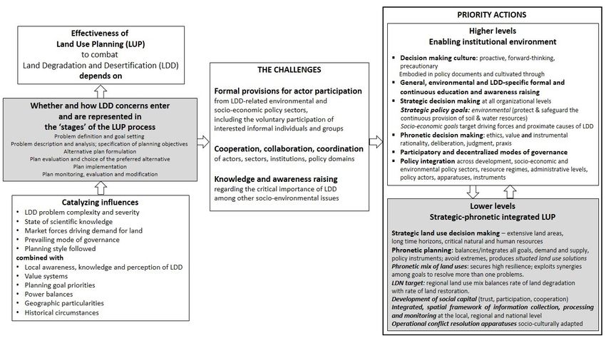
The LUP process comprises certain basic stages: (a) problem definition and goal setting; (b) problem
description and analysis; specification of planning objectives; (c) alternative plan formulation; (d) plan
evaluation and choice of the preferred alternative; (e) plan implementation; (f) plan monitoring, evaluation
and modification [52,54,60]. Figure 1 schematically presents this process and briefly describes the stages.
These stages are not discrete and clearly delineated, they do not necessarily follow a linear succession in
practice and they may overlap as some planning activities take place contemporaneously (e.g., problem
definition and description, plan formulation and evaluation). Their boundaries are blurred, continuous
feedbacks occur from one to another as demand and supply-related environmental and socio-economic
conditions change, new actors get involved, new information is gathered, thus, continuously modifying
the definition of the planning problem and the subsequent stages.
Land-use planning, like planning in general, is both a technical and a political process [61,62] that
serves three functions: an intelligence function (data collection and analysis to build the information
base concerning the demand and supply side of the planning problem), advance plan-making and
action/implementation [52]. Depending on how LUP and the elements of the process are conceived,
and on whether a proactive or a reactive decision making culture prevails, different planning styles
(or, modes) are followed in practice. These include the classical (and by now mostly defunct)
comprehensive or synoptic planning, incremental, transactive, advocacy, mixed scanning, contingency,
adaptive and participatory planning [56,61,63,64]. The last three styles are particularly important in
the case of natural hazards in general and LDD in particular.
In contemporary democratic, but increasingly complex societies, desirable features of LUP
necessary to enhance its performance and effectiveness are strategic orientation, coordination and
integration with development planning, wide participation (bottom up decision making), flexibility
and adaptation [58,65,66]. These require well developed social and institutional capital and, above all,
political will to devise and implement scientifically sound and socially acceptable solutions to
socio-ecological problems that are characterized by considerable uncertainty [56]. In this context,
the coordinating role of the advance plan-making function is critical in bridging the technical
(intelligence) with the political (action/implementation) functions of LUP, thus, underlining the
role of both science and politics in judging the outcomes of the process.
On the technical front, present-day LUP employs a variety of approaches, such as the landscape,
the ecosystem and the multifunctional land-use approach [67–70], quantitative and qualitative analytical
methods and techniques originating in the natural and the social sciences, such as land suitability analysis,
environmental impact and risk analysis, needs assessment, survey research, environmental and social
impact analysis, scenario analysis, integrated environmental-economic modeling, socio-ecological systems
analysis [64,71–73], and planning support systems as well as traditional and contemporary data collection
techniques (e.g., Earth observation systems, censuses, surveys).
On the political front, LUP combines a broad variety of technical/technological, physical,
economic, financial, social, institutional and educational means and instruments, originating in
environmental and socio-economic policy sectors and in various spatial/organizational levels,
to produce and support the implementation of land use plans. Formal (institutionalized) and informal
negotiation, mediation, bargaining and conflict resolution mechanisms and procedures are utilized
toward this purpose [74,75].
The effectiveness of land-use planning depends critically on the availability of all types of
resources (or, capitals) in the right combinations, in the right place and at the right time to successfully
implement the land-use plan and meet the LUP goals and objectives. These requirements are rarely
met in practice due to several reasons as discussed in the context of combating LDD below.Land 2019, 8, 27 9 of 26
Figure 1. Schematic presentation of the land-use planning (LUP) process and description of the stages.
2Land 2019, 8, 27 10 of 26
3.2. Land-Use Planning to Combat Land Degradation and Desertification
In affected areas, the general land-use planning problem is to determine those uses of land
that will protect their land resources against LDD and will secure their socio-economic vitality
(economic welfare, quality of life and social equity)—i.e., promote their sustainable development.
The LDD-specific goal is to stop, reverse or moderate the degradation of land resources by properly
selecting, siting and monitoring human activities. The land degradation neutrality (LDN) target
gives more concrete, although not necessarily precise, direction: (a) reduce the rate of degradation by
managing land more sustainably; and (b) increase the rate of restoration of degraded land, so that the
two eventually produce zero net land degradation.
In order to assess the prospects of land-use planning successfully meeting the overarching goal of
combating LDD and mitigating the impacts of drought at the local and the regional level, this section
undertakes a reality check of the ideal LUP process; more specifically, it inquires whether and how LDD
concerns enter, or may enter, the stages of the process. For each stage, the interplay of demand and
supply factors is examined with regard to the actors involved, the organizational apparatus (decision
structures and procedures) available and the instruments used. The use of stages is made for the
purposes of analysis only because, as mentioned before, they intermingle and do not follow a given
order in practice.
3.3. Problem Definition and Goal Setting
This stage concerns the question of who defines what problem and sets the LUP goals for the study
area. It is the most critical stage of the LUP process and influences all subsequent stages. It takes place
both formally and informally depending on the institutional status of planning and the administrative
organization and culture that range from formal/centralized to informal/decentralized. A variety of
mixed real world situations are encompassed in between. It is both demand- and supply-driven as
the need for LUP in an area may arise from external or internal demand for its resources by economic
activities and/or from the need to resolve environmental, socio-economic and other problems.
Various kinds of actors are implicated in LUP problem definition and goal setting. Some of
them represent the demand and some other the supply side of the problem. Who and how can
legitimately participate is determined by state laws and the associated procedures and instruments
(e.g., consultation, committee membership).
Formal public actors (individuals and agencies) from various spatial/organizational levels
represent spatial planning, regional and rural development, economic (agriculture, forestry, industry,
extraction, tourism, energy production) and environmental sectors (water, soil, forests, nature
protection, etc.). The latter potentially stand for LDD concerns. Planning consultants are also formally
involved as states usually commission the preparation of LUP studies to specialized firms.
Other individual and collective actors may participate, as in decentralized systems following
inclusionary, participatory processes, or they variously seek to influence formal actors and shift
the LUP problem definition and the goals set to their advantage. These include economic interests
placing demands on land [59], related intermediaries (e.g., construction and real estate sectors), social
and environmental groups (e.g., NGOs, civic groups, etc.). In recent times, actors are increasingly
non-locals (e.g., multinational firms, the EU, the World Bank) as in the case of tourism and second
home development, infrastructure projects, energy production, industrial agriculture and forestry, etc.
LDD concerns may be represented depending on the mandate and interests of these actors. Scientists
may participate formally or they indirectly influence problem definition by disseminating scientific
evidence concerning the magnitude and severity of LDD (studies, maps, indicators, etc.) among
other problems.
Informal actors always co-exist with formal actors, act autonomously and in parallel with
them, placing demands on land resources, making and carrying out their ‘plans’ outside the official
apparatus in affected areas. They often create de facto land uses (e.g., informal agriculture, housing)
and produce environmental, LDD-related problems (e.g., deforestation, fires, overgrazing, waterLand 2019, 8, 27 11 of 26
overdrafting), that formal LUP is called to handle. Informal residential and tourism development
in coastal LDD-sensitive areas in the Mediterranean and elsewhere and illegal deforestation in the
Amazon are cases in point.
The effective legislation mandates the competences of and linkages among formal actors.
The diverse linkages developing between formal and informal actors as well as among informal
actors take two basic forms; coordination/cooperation or conflict. The perception and knowledge
of the problems of the area, the vision regarding its future, the congruence of aspirations and the
common interests among actors as well as the presence of externalities of the respective activities judge
whether cooperation or conflict will result. In the case of conflicts, both formal and informal, customary
conflict resolution procedures and prevailing power balances determine the outcome. Obviously,
communication, common understanding and coordination among actors are necessary to produce a
coherent LUP problem definition that encompasses LDD concerns. However, scientific uncertainty
regarding LDD and its causes, together with lack of hard local and regional evidence, leaves ample
room for multiple interpretations and adaptation to local circumstances.
The spatial, sectoral and administrative diversity and plurality of formal and informal actors,
possessing differing mandates and knowledge of LDD, the compartmentalization of administrative
structures even for the same resource (e.g., land, water, etc.) and turf politics [37] often result in
vague and incoherent definitions that show up in goal setting. Formal LUP goal setting follows either
in a top-down process, in the case of centralized systems and hierarchical modes of governance,
or some form of participatory process in more decentralized systems. General national goals,
often incorporating international obligations (e.g., climate change), include sustainable development,
economic development, resource protection and conservation, as well as specific goals such as
agricultural specialization, tourism development and energy production. Strategic goals concerning
the protection of critical resources (water, soil, air, etc.), food and energy security, and others may be
also specified. LDD-specific goals are included in the case of duly constituted NAPs. Agreement over
general goals is usually easy to achieve especially if all actors share a common development vision
for the area. Conflicts arise later when the more detailed planning objectives formulated reveal the
critical trade-offs.
The priorities set among goals reveal the influence of dominant actors. The decisions regarding the
uses of land are made on the basis of economic considerations mainly (demand side), often by nonlocal
interests, and rarely on the basis of environmental considerations (supply side) except for symbolic
purposes and extreme cases of environmental degradation, including LDD. Therefore, the protection
of land resources is one of several socio-economic and environmental goals of LUP in affected areas,
which depend on the specifics of each individual case but are, most likely, intricately related to LDD.
The perception and knowledge of LDD which the formal and informal actors hold, that depend on scale,
sector and social group, and the prevailing proactive or reactive decision culture critically determine
the sense of urgency and the priority it is given compared to other problems. The possibilities range
from total ignorance (theoretically possible but practically rather unlikely) to complete knowledge and
concern for its impacts. At the local level, LDD is perceived as land degradation, not as desertification,
and it is of direct concern to agricultural interests and environmental groups. LDD-related goals
may be congruent and synergistic with certain goals, such as environmental protection, resource
conservation and food security, or incompatible and antagonistic with some others, such as large-scale
industrial, energy and tourism development. When goals conflict, the need for trade-offs among them
and for specific LUP objectives that support consensus land use patterns arises.
LUP problem definition and goal-setting do not remain constant. They are often revised and
modified especially when LUP processes are protracted. Economic, socio-cultural, environmental,
administrative and political changes occurring at all levels modify environmental conditions (positively
or negatively), introduce new actors, legislation and planning modes (e.g., participation), bring about
changes in demand for land from new activities and different lifestyles, provide new knowledge
and necessitate changes in priorities among goals. These changes create considerable uncertaintyLand 2019, 8, 27 12 of 26
and necessitate emphasis on strategic goals, continuous top down-bottom up communication and
coordination and broad actor representation and participation as well as integration, flexibility
and openness as early in the LUP process as possible. However desirable these features may be,
which characterize decentralized systems and are absent from hierarchical planning systems, they
underline the complexity and explain the difficulties to come up with clear, coherent and consistent
LUP problem definitions and goals in affected areas that prioritize combating LDD.
3.3.1. Problem Description and Analysis; Specification of Planning Objectives
Following the LUP problem definition, this stage aims, on the one hand, to set up the indispensable
basis of plan making, i.e., the comprehensive and reliable description of the biophysical and human
structure, dynamics and problems of the area, including LDD, and, on the other, to specify the
LUP objectives.
Formal actors and external consultants are the most important actors at this stage although the
role of other actors interested in the resources of the area should not be downplayed. The effective
legislation may prescribe the relationships among these actors, such as formal requirements for plan
development and the instruments (consultations between formal actors, consultants and the public)
that have to be used. However, the most important relationships are informal, occurring during
problem description, analysis and formulation of LUP objectives. New actors enter the process, such as
data and information providers, new users of land and new formal actors, different from those involved
in problem definition, responsible for formulating the specific LUP objectives.
Consultants take the problem definition and goals set as given but may propose modifications
based on the description and analysis of the information and data collected for the affected area as well
as on pertinent scientific theories, including those related to LDD. In this way, they may proactively
introduce new concerns, activities and actors as well as underline the uncertainty surrounding the
causes and effects of LDD and other problems of the area, thus, paving the road for feedbacks and
problem redefinition and goal reformulation.
From the viewpoint of properly describing and analyzing LDD, the most important issues concern
(a) the theoretical framing of the evolution and problems of the area; (b) the availability of reliable
assessment techniques; and (c) the availability of suitable data. Scientific theories developed at higher
spatial levels, including those contained in the NAPs, cannot satisfactorily address the causality of
land use change and LDD at the local and regional level because they ignore the numerous, tangible
and intangible, place-specific and contextual factors and their changes. Study area-specific theoretical
frameworks are necessary to guide the situated description and analysis of the affected area for the
purposes of LUP especially with respect to combating LDD [25,27,48,76].
Numerous LDD assessment methodologies, indicators and indices have been developed in the last
decades to describe the extent and severity of LDD as well as to support LDD abatement decisions at
the global, national and local/regional level [77–89]. The Environmental Sensitivity Assessment (ESA)
methodology [79], in particular, concerns the assessment of desertification risk on the basis of selected
indicators of climate, soil, vegetation and land management at lower levels (landscape/watershed,
regional, national). It is continuously being used widely up to the present [90–96] and it has been
refined through the application of Remote Sensing and GIS techniques [97–100].
From the viewpoint of their utility for LUP purposes at the local/regional level, the assumptions
and limitations of these assessment methodologies and indicators should be kept in mind. Most of
them use variables (or, indicators) for which published, regularly collected data are readily
available. Issues related to the data used arise as discussed below. The operationalization of
several factors (e.g., policy, land management) is based on expert judgment (for obvious reasons).
Their suitability and transferability to lower levels of analysis and particular resources (point andLand 2019, 8, 27 13 of 26
nonpoint)14 , the assessment and mapping of LDD-related issues, such as the rate of degradation and
the rate of restoration of degraded land, carrying capacity and many more remain open issues that
should be treated judiciously [25,28,48,101].
The theoretical and methodological issues briefly discussed above raise important issues with
respect to the suitability of existing data bases for the spatial scale and unit of analysis15 and the time
period for a LUP problem at hand. Existing data may concern units of analysis (e.g., mapping units,
land units) that do not correspond to the actual decision making units in the study area [102] and
may not be available for long time periods for all variables (environmental, economic, social, etc.) of
interest. Aggregate land-use types (used in current data bases) may conceal more detailed uses of
land at the level of the study area as human activities are multi-purpose and nonhomogeneous and
more than one activities may occupy the same tract of land (the case of multifunctional landscapes) or
co-exist vertically (the case of high-rise urban areas)16 . Spatio-temporally consistent environmental,
socio-economic and other data may be also lacking [102]. Lack of suitable data do not favor valid
assessments and mapping of baseline values of pertinent LDD indicators (see, e.g., [38,87]), impact
assessment of past interventions (e.g., policy measures) and of land-use change as well as projections of
future demand (population, income, tourism, etc.) and supply of local resources (i.e., carrying capacity,
potential, sensitivity and thresholds of critical biophysical and other factors). In sum, for LUP purposes
the assessment methodologies and indicators should be used with caution as helpful but indicative
and not the only guides to describe and assess, but not explain, the incidence and severity of LDD,
to set LUP LDD-specific objectives, to operationalize the LDN target and to make land use decisions.
Numerous other factors complicate the description and analysis of affected areas such as the
incidence of unexpected changes and the long time horizons that introduce uncertainty in predicting
future land-use change, lack of appropriate environmental and socio-economic monitoring, and so
on. Most importantly perhaps, lack of time, human and financial resources, data and expertise
may preclude the use of suitable analytical techniques in area-specific analyses in LUP studies.
These issues deem necessary detailed data collection and monitoring as well as analytical studies that
are indispensable for formulating reliable study area-specific planning objectives in support of LUP to
combat LDD, among other goals. Recent trends towards participatory data collection and analysis
approaches [103,104] may partially ease the resolution of these issues.
3.3.2. Alternative Plan Formulation
Alternative land-use plans may be formulated to suggest different courses of action to match the
present and future demand for land resources with the present and future supply of these resources to
achieve the goals and the area-specific planning objectives set, a task critically hinging on problem
description and analysis. In affected areas, the most critical question is which land use configuration
can satisfy the goal of combatting LDD and the LDN target (or else, how the LDN target is integrated
in LU plans) while meeting all other planning goals and objectives.
Plan formulation aiming at environmental protection and resource conservation should be
proactive, guided, on the one hand, by strategic choices regarding critical land resources and, on the
other, by the prevention, the precautionary and other principles [65,105]. The plans thus produced are
more likely to safeguard the constant functioning of natural systems and the provision of ecosystem
14 Such as erosion models, agro-ecological zoning, statistical models, impact assessment and future projection models (climate,
population, demand, supply, etc.).
15 As [3], (p. 117) has noted: “ . . . proper analysis and meaningful resolution of environmental problems can take place only
within natural spatial units, such as watersheds (Manning, 1988). However, practical considerations (data availability and
ease of implementation mainly) dictate the use of administrative units most of the time, the result being fragmented, partial,
and often ineffective solutions to these problems. Efforts to combine the two types of entities into geopolitical units, such as
the ‘environomic units’ being developed in Canada (Gelinas, 1988), should be encouraged, as well as the formation of
inter-jurisdictional bodies . . . ”
16 The problem is more acute for small study areas that may suffer from severe LDD.Land 2019, 8, 27 14 of 26
services that constitute the enabling condition of sustainable development [106]. In this context,
an important consideration is the property status of land and other resources, such as water; i.e.,
whether they are private, state or common property [107,108] that significantly influences land-use
allocation decisions17 [109,110]. It is noted, however, that land resources, irrespective of property
status, are common pool resources18 that should be preserved for the benefit of all present and future
users [111]. Given the fundamental role of soil and water resources in the LDD context and not only
that, it follows that their protection should constitute a strategic LUP goal. While water resources enjoy
a more or less satisfactory legislative protection and status in plan formulation, this not the case with
soil resources. Land-use plans often prescribe uses of land that give rise to several soil threats—erosion,
decline in organic matter, sealing, contamination, compaction, decline in biodiversity, salinization,
landslides [46]—that increase the risk of LDD especially in sensitive affected areas.
Alternative plan formulation is usually carried out by planning consultants (including scientists)
in cooperation and consultation with formal actors but also with diverse other interested actors,
some of them entering at this stage of making critical land use allocation decisions. Guidance
regarding how land-use plans should meet LDD-specific objectives such as improving the rate
and extent of land restoration and reducing the rate and extent of land degradation is missing.
The UNCCD sets broad goals and lacks operational guidelines and satisfactory indicators to measure
progress at lower levels [32]. The NAPs usually focus on land uses related to the proximate causes of
LDD—agriculture, animal husbandry, forests and, to a lesser extent, on tourism, extraction, transport,
energy (e.g., renewable energy sources) and large infrastructure works (transport and energy networks,
airports, etc.). They propose general activity-specific measures to minimize LDD because pertinent
policy measures and instruments, such as environmental regulations, sustainable land management
(SLM) practices, subsidies, etc., may be already in place and usually agree with dominant sectoral
preferences. This is the case of the EU CAP agri-environmental and cross-compliance measures [33].
The focus on known proximate causes of LDD agrees with the common LUP practice where the
uses of land in an area are determined by the present or future demand for land by economic activities.
Activity-specific obligations are formally specified in order to avoid resource degradation and other
predictable externalities. This practice of coupling demand with supply overlooks two important
issues. First, the status of land resources is affected by numerous and diverse indirect drivers that
modify, in one way or another, the demand for and thus, the pressures on land resources. These include
outmigration, land abandonment, socio-economic restructuring, changes in urban-rural dynamics,
changes in life styles (e.g., trends towards eco-living, eco-tourism, etc.), land and other taxation,
and so on. This implies that, second, changes in these drivers may preclude the realization of chosen
land-use combinations or, if realized, drastically modify their anticipated impacts, leading to either
deterioration or effective protection of land resources. Therefore, LUP instruments, such as zoning
(of hazard-prone and sensitive landscape areas), natural and cultural reserves, multifunctional land
use schemes, should be coupled with economic, fiscal and other instruments, e.g., land and general
taxation, incentive schemes, voluntary measures, to attain the LDN and related objectives [68,110].
This broadened perspective necessarily leads to the quest for integrated land-use planning that
has been voiced since the early discussions of the issue [43,48] and more recently in discussing the
materialization of the LDN goal [27,38]. The need for integrated and situated land-use plan formulation
becomes evident at this stage of plan formulation as the effectiveness of any land-use plan depends on
the spatial coordination of several activities, policy instruments, etc. at the level of the study area and
across levels to promote individual and collective goals.
17 Private interests exert pressures on the LUP process and significantly affect the choices made.
18 Common Pool Resources (CPRs) are characterized by (a) non-excludability—they are indivisible and, thus, nobody can
be ethically or practically be excluded from using them and (b) subtractability—they are finite and, thus use by one user
reduces the amount of resource available to others [107,108].You can also read