Linking welfare distribution to land records: a case-study of the Rythu Bandhu Scheme (RBS) in Telangana - Finance ...
←
→
Page content transcription
If your browser does not render page correctly, please read the page content below
Linking welfare distribution to land records: a case-study of
      the Rythu Bandhu Scheme (RBS) in Telangana

                          Susan Thomas
                            Diya Uday
                         Bhargavi Zaveri
         Indira Gandhi Institute of Development Research
                            TR-2020-4-27

             Indira Gandhi Institute of Development Research
                                Mumbai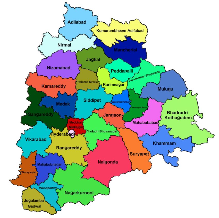
Contents
List of Figures 1
List of Tables 2
1 Introduction 4
2 Summary of findings 8
3 Approach and methodology 12
3.1 Understanding capacity at the level of the state and district . . . . . 12
3.2 Selection of districts and villages . . . . . . . . . . . . . . . . . . . . 14
3.3 Understanding citizens’ perspectives at the village level . . . . . . . 16
3.4 Error estimation in delivery of benefits under the RBS . . . . . . . . 16
4 State and district profiles 18
5 Land Records Updation Program (LRUP) 22
5.1 Legal framework governing land administration and land records . 22
5.2 State of land records prior to the LRUP . . . . . . . . . . . . . . . . . 26
5.3 Implementation of the LRUP . . . . . . . . . . . . . . . . . . . . . . 27
5.4 Departments involved in the administration of the LRUP . . . . . . 28
5.5 Budget . . . . . . . . . . . . . . . . . . . . . . . . . . . . . . . . . . . 35
5.6 Outcomes . . . . . . . . . . . . . . . . . . . . . . . . . . . . . . . . . 35
6 Land records updation in forest areas 40
7 Rythu Bandhu Scheme (RBS) 43
7.1 Departments involved in the implementation of the RBS . . . . . . 43
7.2 Implementation of the RBS . . . . . . . . . . . . . . . . . . . . . . . . 45
7.3 Budget . . . . . . . . . . . . . . . . . . . . . . . . . . . . . . . . . . . 49
7.4 Outcomes . . . . . . . . . . . . . . . . . . . . . . . . . . . . . . . . . 50
8 Conclusion 63
9 Acknowledgements 68
List of Figures
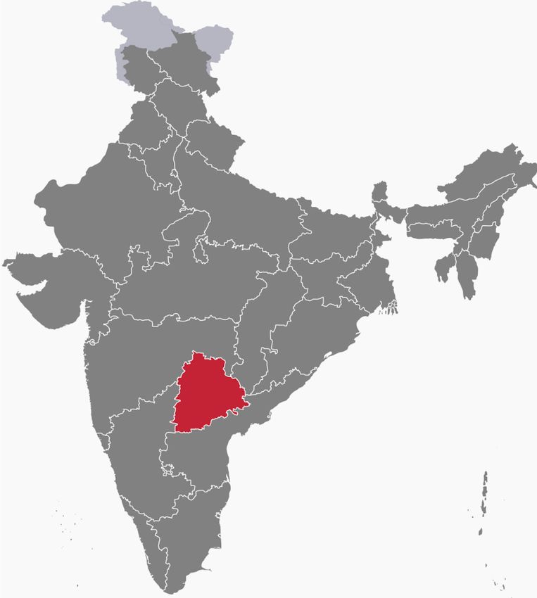
1 The State of Telangana . . . . . . . . . . . . . . . . . . . . . . . . . . 18
2 District-level map of Telangana . . . . . . . . . . . . . . . . . . . . . 19
3 Revenue Department: Organisation structure . . . . . . . . . . . . . 29
4 Information flow in updating and creating records under the LRUP 34
15 Process for grant of pattadar passbooks (PPBs) to holders of Recog-
nition of Forest Rights (ROFR) certificates . . . . . . . . . . . . . . . 41
6 Agriculture Department: Organisation chart . . . . . . . . . . . . . 45
7 Integrated Tribal Development Agency (ITDA): Organisation struc-
ture . . . . . . . . . . . . . . . . . . . . . . . . . . . . . . . . . . . . . 46
8 Comparison of the process flows in cheque distribution and direct
benefit transfers (DBTs) . . . . . . . . . . . . . . . . . . . . . . . . . . 48
List of Tables
1 Overview of farm income support schemes introduced in 2018-19 . 5
2 Overview of questionnaires: state and district levels . . . . . . . . . 13
3 District selection parameters . . . . . . . . . . . . . . . . . . . . . . . 15
4 Matrix for estimating inclusion and exclusion errors . . . . . . . . . 17
5 Administrative divisions, size and demographic profile . . . . . . . 20
6 Land use pattern in Telangana (2016-17) . . . . . . . . . . . . . . . . 21
7 Size of agricultural landholdings . . . . . . . . . . . . . . . . . . . . 21
8 Legal framework governing land administration and land records
in Telangana . . . . . . . . . . . . . . . . . . . . . . . . . . . . . . . . 23
9 Land records maintained in rural areas . . . . . . . . . . . . . . . . . 24
10 Fields of information in Pahaani records . . . . . . . . . . . . . . . . 24
11 Persons eligible to apply for PPB in Andhra Pradesh and Telangana 26
12 Overview of capacity used in the LRUP . . . . . . . . . . . . . . . . 28
13 Administrative hierarchy - Revenue . . . . . . . . . . . . . . . . . . 29
14 Village-wise reports to be filed by District Collectors . . . . . . . . . 32
15 Budget estimates for land reform in rural areas . . . . . . . . . . . . 35
16 Coverage of LRUP (districts, villages and area) . . . . . . . . . . . . 36
17 State-level outcomes under the LRUP: area, no. of land parcels and
PPBs issued (as on 4th June, 2019) . . . . . . . . . . . . . . . . . . . . 37
18 District-level outcomes under the LRUP: no. of khatas and PPBs
issued (as on 4th June, 2019) . . . . . . . . . . . . . . . . . . . . . . . 38
19 Outcomes of district-level disputed cases under the LRUP (as on 4
th
June 2019) . . . . . . . . . . . . . . . . . . . . . . . . . . . . . . . . 40
20 District-level disputed khatas . . . . . . . . . . . . . . . . . . . . . . 40
21 District-level outcomes in respect of ROFR . . . . . . . . . . . . . . 42
22 Coverage of farmers under the RBS . . . . . . . . . . . . . . . . . . . 43
23 Administrative hierarchy - Agriculture . . . . . . . . . . . . . . . . . 44
24 Administrative hierarchy - ITDA . . . . . . . . . . . . . . . . . . . . 45
25 Designated Banks for RBS . . . . . . . . . . . . . . . . . . . . . . . . 47
26 Broad heads of expenditure for the administration of the RBS . . . 49
27 Sample size and distribution of farmers interviewed in the sample
villages . . . . . . . . . . . . . . . . . . . . . . . . . . . . . . . . . . . 50
228 Profile of respondents in the focused group discussions (FGDs) . . 51
29 Profile of respondents: farmers with disputed titles . . . . . . . . . 51
30 Indicative list of FGD questions on awareness . . . . . . . . . . . . . 52
31 Indicative list of FGD questions on operationalisation and imple-
mentation . . . . . . . . . . . . . . . . . . . . . . . . . . . . . . . . . 53
32 Indicative list of FGD questions on service delivery . . . . . . . . . 54
33 Indicative list of FGD questions on service delivery . . . . . . . . . 55
34 Average annual expenditure of beneficiary farmers in the FGDs . . 56
35 Snapshot of LRUP and RBS outcomes . . . . . . . . . . . . . . . . . 56
36 Relevant entries in Pahani records . . . . . . . . . . . . . . . . . . . 58
37 Overview of entries in Pahani records of Marriguda and Shapally . 59
38 Profile of Pattadars and their landholding in Marriguda and Shapally 59
39 Estimation of inclusion and exclusion errors in the administration
of the RBS . . . . . . . . . . . . . . . . . . . . . . . . . . . . . . . . . 60
40 Discrepancy in area calculation across Pahani records and RBS ben-
eficiaries’ list . . . . . . . . . . . . . . . . . . . . . . . . . . . . . . . . 61
41 Excess payout in the sample villages under the RBS . . . . . . . . . 62
31 Introduction
The Indian government, at the centre and at the level of the states, provides sup-
port for the agriculture sector in several forms, such as through subsidising in-
puts, access to cheaper capital, loan waivers and minimum support prices for
outputs. In the last five years, there is an increasing trend towards direct cash
transfers as one of the main tools of supporting farmer welfare. While most of
these efforts have been concentrated at the state level, the interim budget 2019-
20 introduced the Pradhan Mantri Kisan Samman Nidhi (PM Kisan Scheme), the
first fully centrally sponsored income transfer scheme for farmers. The scheme
proposes to transfer an annual income support of Rs.6,000 to the bank accounts
of small and marginal farmers. This is a unique scheme in that it almost entirely
relies on land records for the identification of beneficiaries. Since the entitlement
to the income support is linked to land ownership, the successful implementation
of the scheme is directly linked to the robustness and accuracy of the underlying
land records infrastructure.
The PM-Kisan Scheme Operational Guidelines 2016 specify a cut-off date for eligibil-
ity of beneficiaries, and make the States responsible for the identification of ben-
eficiaries for the purpose of the PM Kisan Scheme. The design of the scheme and
its linkages to land records poses unique challenges with respect to the identifi-
cation of beneficiaries on the basis of land records.1 Apart from the land records
databases, the identification process possibly requires co-ordination between var-
ious state government departments as well as the integration of databases and
de-duplication efforts. These challenges naturally lead to questions of state ca-
pacity for the effective implementation of the PM Kisan Scheme.
Apart from the central government, three other states, namely, Odisha, West Ben-
gal and Andhra Pradesh, have also announced and are in different stages of im-
plementing, similar income support schemes for cultivators of agricultural land.
2
Table 1 gives an overview of the features of these schemes.
1
The scheme provides for income support to small and marginal farmers family, which is de-
fined as “a family comprising of husband, wife and minor children who collectively own cul-
tivable land upto 2 hectare as per land records of the concerned State/UT”.
2
The Krushak Assistance for Livelihood and Income Augmentation (Kalia) scheme announced
by the Odisha government, the Annadata Sukhibhava announced by the government of Andhra
Pradesh and the Krisak Bandhu scheme announced by the government of West Bengal, entitle
farmers who cultivate land to cash support.
4Centre Telangana Andhra Pradesh Odisha West Bengal
Name PM Kisan Scheme RBS Rythu Bharosa Kalia Krishak Bandhu
Year of an- 2019 2018 2019 2018 2018
nouncement
Basis of calcula- Absolute Per acre basis Absolute Absolute Per acre
tion
Annual amount 6,000 10,000 7,500 4,000 5,000
Number of in- 3 2 Unclear 2 2
stalments
Eligibility Land owners Land owners Land owners & Land holders & Unclear
tenant cultivators tenant cultivators
Annual budget 75,000 12,000 8,750 5,611 3,000
allocation (INR
crores)
Targeted num- 120 (households) 6 (farmers) 4 (farmers) 7.5 (households) 7.2 (farmers)
ber of beneficia-
ries (millions)
5
These features are extracted from the scheme documents available in public domain as on January 2020.
Table 1: Overview of farm income support schemes introduced in 2018-19Table 1 shows that in a span of two years, five major income support schemes
have been announced in India. These schemes link the income support to the type
of land held by the beneficiary, namely, agricultural land. Two of these schemes
link the amount of the entitlement to the size of the land parcel, and at least two
of them link it to land ownership.
While it is clear from the PM Kisan Scheme and RBS scheme documentation that
the list of beneficiaries will be drawn up from land records, the manner of identi-
fication of beneficiaries under the other schemes is unclear. However, a common
theme running across these schemes is farm income support linked to agricul-
tural land holding (whether on possession or ownership basis).
The level of preparation and state capacity deployed prior to the implementation
of the schemes has differed from state to state. For instance, while the Telangana
government undertook a LRUP prior to operationalising the RBS, Odisha and
West Bengal governments did not make any structural changes to the quality of
their land records infrastructure prior to rolling out the schemes. The variation
in the quality of land records across states and the state capacity for the identifi-
cation of beneficiaries, will naturally affect the delivery of programs like the PM
Kisan Scheme.
In this context, Omidyar Network commissioned a study on the RBS, with the
objective of understanding the state capacity that was deployed in the concep-
tualisation, operationalisation and implementation of the RBS. Specifically, this
study seeks to answer the following questions in the context of the RBS:
1. What is the extent and scope of the land reforms that were undertaken by
the state government prior to operationalising the Rythu Bandhu scheme?
2. What institutional mechanisms have been set up by the government of Telan-
gana to operationalise the distribution of welfare benefits linked to land
ownership?
3. What is the state capacity needed, both in quantitative and qualitative terms,
for Rythu Bandhu?
4. What are the gaps, if any, in the implementation of the Rythu Bandhu scheme?
5. What solutions can be implemented at the state-level and the local level to
fill these gaps?
Given the increasing instances of states linking welfare distribution to land records
in the last two years, the learnings of this study can be potentially applied to
analyse the state capacity involved, the design features and potentially the effec-
tiveness of land records linked welfare distribution for the overall economic well
being of farmers in India.
6This report contains the findings of this study. The report is organised as fol-
lows. Section 2 gives an overview of the key findings of our study. Given that
the LRUP immediately preceded the implementation and laid the foundation for
the RBS, we study the implementation of the LRUP in as much detail as that of
the RBS. This gives a holistic perspective of the state capacity deployed by the
state government of Telangana for rolling out the RBS. Section 3 describes our
approach, methodology and tools used for the purpose of this study. We rely on
legislation and internal departmental circulars issued by the departments of the
state government involved in the implementation of the LRUP and the RBS. To
understand the resourcing used for both these programs, we interview officers
of these departments at the level of the state, two select districts and a village in
each of these districts. To understand the outcomes of both these initiatives, we
conduct two separate exercises. First, we conduct FGDs with the beneficiaries
and persons excluded from the design of the RBS. Second, we attempt to esti-
mate the extent of wrong exclusion and over-inclusion under the RBS in the two
selected villages. In Section 4, we present a brief profile of the state of Telangana,
the two selected districts and villages. Sections 5 and 7 present our findings on
the design, administrative structures of the departments involved, the capacity
created and utilised, and the outcomes of the LRUP and the RBS respectively. In
Section 8, we conclude with some learnings and takeaways from the LRUP and
the RBS on linking land records with welfare distribution.
72 Summary of findings
The objective of this study was to gain an in-depth understanding of the capac-
ity built by the state of Telangana before rolling out the RBS. Telangana is an
interesting and a special case for studying the implementation of an agriculture
income support scheme. This is because unlike the other states that have rolled
out similar schemes, the state government of Telangana undertook a state-wide
land records updation drive, which involved the rectification of errors, updating
the land records and the issuance of digital and secured PPBs to the owners of
agricultural land parcels.3 We approach this study at the level of the state, two
selected districts, namely, Nalgonda and Mulugu and a village (Marriguda and
Shapally) in each of these districts.
Both the LRUP and the RBS target agricultural land and the rural population
only. We find that while the urban population in Telangana has been steadily
increasing at a higher pace than the national average, a little more than half the
population continues to live in rural areas and nearly 43% of the total area of
the state is actually cultivated (Table 6). Further, bulk of the agricultural land
holdings in Telangana are in the marginal to small category, that is, they measure
anywhere between 0.1 to 2 hectares (Table 7). For the purpose of our study, we
selected Nalgonda and Mulugu, because among other reasons, they have a large
concentration of small and marginal agricultural landholdings.
The LRUP
At the outset, we find that even before rolling out the LRUP, the state government
of Telangana had been undertaking land reforms on a sustained basis. This is
evident from the year-on-year expenditure on land reforms, as reflected in the
annual financial statements published by the state government (Table 15). The
LRUP was initially undertaken on a pilot basis in some districts before it was
rolled out across the state. This is a critical takeaway as it indicates a progressive
trend towards land records updation and while the official duration of the LRUP
spanned three months, it appears that the state government has had a consistent
focus on ’land reforms’ since 2016-17.
During the three months of the project, the LRUP covered 32 out of the 33 districts
of Telangana, spanning nearly 86% of the area of the state. The design of the
LRUP has important implications for the speed and efficiency of the program.
First, the law was amended to simplify the format of PPBs by dispensing with
the requirement to record any interest other than that of ownership (referred to as
’Pattadars’) in the PPB. Thus, interests that are inherently more difficult to record,
such as actual occupants and mortgages, are not reflected in the PPBs (Table 11).
3
PPBs is a land record that was unique to the erstwhile unified state of Andhra Pradesh and
subsequently adopted by the government of the newly formed Telangana state.
8Second, the program was carried out in two phases: the first phase would involve
the issuance of PPBs only to those Pattadars whose title to their parcels was not
disputed; and the land parcels with disputed titles would be kept for the second
phase of the program. This ensured that the capacity was not diverted toward
resolving title disputes to land. In terms of capacity, we find that no specific new
capacity was created for the implementation of the LRUP and that 3,500 officers of
the Revenue Department organised themselves into 1,507 teams for the purpose
of implementation (Table 12).
Contrary to the popular notion of land being a relatively highly disputed area,
nearly 95% of the area covered was cleared for the first phase. This means that
there was no major dispute with respect to the ownership of agricultural land
parcels comprising 95% of the area covered under the LRUP. However, it is pos-
sible that the disputes in respect of these land parcels would be mitigated by
two factors. First, the LRUP was not preceded by a survey. Second, the LRUP
involved the updation of a limited number of fields of information in a PPB.
For 93% of the cleared agricultural land parcels, digital PPBs have already been
issued (Table 17). The disputed land parcels were classified into one of 33 cate-
gories, such as pending civil court or revenue court case, boundary dispute and
so on (Box .1). In terms of number of agricultural land parcels, about 5.62% of the
land parcels are disputed. We find that about 6% of the agricultural land parcels
were disputed in Nalgonda and about 4% of them were disputed in Mulugu (Ta-
ble 20).
The RBS
Once the implementation of the LRUP was complete and PPBs were distributed
in respect of the bulk of the cleared Khatas, the LRUP database was handed over
by the Chief Commissioner of Land Administration (CCLA) to the Commissioner
and Director of Agriculture (CAD) for the identification of beneficiaries under the
RBS. The RBS involves payment of a benefit of Rs.5,000 per acre to every land
owner for the Kharif and Rabi seasons. The RBS does not envisage payment to
tenants of agricultural land. However, holders of ROFR certificates would be
entitled to claim RBS benefits although they are technically not owners of the
forest land cultivated by them. Also, owners of agricultural land parcels that
were disputed under the LRUP could not avail of the benefits of RBS. Further, the
RBS scheme is an unconditional transfer, that is, a beneficiary identified under
the scheme would be entitled to claim the benefit even if she does not actually
cultivate the land owned by her. Also, no beneficiary is required to submit proof
of utilisation of the previous benefit amount.
The Agriculture Department is entirely in charge of implementation of the RBS,
and the role of the Revenue Department is to provide updated land records data
to the Agriculture Department prior to every season of distribution.
9The total number of beneficiaries under the RBS is 16,62,169 with an average of
nearly 54,000 beneficiaries per district (Table 22). We find that while for the first
season, the RBS entitlement was distributed through the medium of cheques, the
state government has subsequently shifted to the DBT mode of delivery. Resul-
tantly, the entitlement is now directly transferred from the account of the state
government with the Reserve Bank of India (RBI) through the e-Kuber platform.
This has considerably reduced the costs and administrative capacity required for
the purpose of the RBS (Figure 8).
A budget of Rs. 12,000 crores was provided for payment of the RBS entitlements
for the financial year 2018-19. This was on the basis that the RBS entitlement was
Rs.4,000 per acre. However, with effect from 2019-20, the State Government in-
creased the RBS entitlement to Rs.5,000 per acre. On this basis, it is estimated
that the RBS budget for the year 2019-20 (beginning Kharif 2019) should be en-
hanced to Rs.15,000 crores. However, the budget speech for 2019-20 indicates that
a sum of Rs.12,000 continues to be allocated for the purpose of the RBS. A deeper
analysis of the budget documents indicate that the state has made a provision
of Rs. 9,056 crores for the purpose of the RBS. The shortfall in the budget allo-
cation, despite an increase in the amount of entitlement, remains unexplained.
This is perhaps reflected in the relatively higher levels of farmers reporting the
non-receipt of their entitlement for the Rabi 2019 season.
We find that while the beneficiaries are aware of the RBS and the mechanism to
avail it, the level of awareness among tenants is relatively lower. We also find
that the RBS entitlement covers about 10% of the average annual expenditure of
a small and marginal farmer and about 6% of the average annual expenditure
of the medium to large farmer (Table 34). We also find that in the absence of a
specific grievance redressal mechanism, farmers are unclear about the forum to
redress their grievances.
We begin to estimate the error in the calculation of beneficiaries by comparing
the data available on the number of PPBs issued with the number of beneficiaries
under the RBS, at the state level. We estimate the total number of beneficiaries as
a sum of the number of PPBs holders and the number of ROFR certificate holders.
On this basis, we find no exclusion error and estimate an inclusion error of about
9.37% in the number of beneficiaries. However, this approach has its limitations
as it does not rely on the base land records, namely, the Pahaani. It also does
not offer insights into the estimation errors, if any, in the area covered under the
RBS. This is critical from a budgetary outlay perspective as the RBS entitlement
is linked to the area of the land parcel owned by the farmer.
We, therefore, adopt the approach of comparing the base land records and the
number of beneficiaries to get a more holistic picture of the estimation errors in
terms of the number of beneficiaries and the area. However, we limit this exercise
10to two villages, namely, Marriguda and Shapally. On comparison of the base
land records and the RBS beneficiaries’ list for Marriguda and Shapally villages,
we find that while Marriguda has a 20% exclusion error, Shapally does not have
any exclusions, but has a 16% over-inclusion error, in terms of the number of
beneficiaries. We also note significant discrepancies in the area of agricultural
land covered in the base land records and the RBS beneficiaries’ list. We find that
there is a discrepancy in the area recorded for more than 50% of the beneficiaries
in Marriguda village and about 40% of the beneficiaries in Shapally village.
Among the beneficiaries who witness a discrepancy in the area recorded in the
Pahani records and the RBS beneficiaries’ list, bulk of the beneficiaries witness a
disrepancy of between 0.5 to 1 acre. This means that for most of the beneficia-
ries, the RBS list records anywhere between 0.5-1 acre more or less area than that
recorded in the base land record for that beneficiary. The average discrepancy is
towards recording surplus area in the RBS beneficiaries list. On an average, the
beneficiaries’ list of Marriguda records 0.55 acres surplus area held by a benefi-
ciary; and the RBS beneficiaries’ list of Shapally records 0.17 acres surplus area
held by a beneficiary (Table 40). This has important implications for fiscal slip-
page under the state budget for the RBS, and underscores a need for periodic
audits to be conducted to minimize slippages.
113 Approach and methodology
The literature on welfare distribution in India since 2013 has largely focused on
the impact of DBT, which was widely taken up by the Central Government as
the primary mode of delivering welfare to citizens (Aiyar 2019). This seems to
be on par for the course as the adoption of DBTs has reportedly curbed signifi-
cant leakage in the welfare distribution system (Nandi and Bhaskar 2019). The
literature on DBT has, in turn, focused on the quality of implementation and the
satisfaction level of citizens who are recipients of DBT benefits. For example, Mu-
ralidharan, Nihaus, and Sukhtankar 2017 studied the scheme that replaced the
delivery of food ration through the Public Distribution System with DBT in the
Union Territories of Chandigarh, Puducherry and Dadra and Nagar Haveli. They
use household surveys to ascertain the quality of implementation of the DBT for
food in these union territories over a period of one year. Similarly, Gosar and
Mishra 2019 study the satisfaction levels of citizens who opt for theDBT scheme
in place of the LPG subsidy. Both these studies use a survey methodology for
the purpose of their studies. None of these studies focus on questions of state
capacity involved in setting up the system of DBT.
More specifically, there is little literature that traces the state capacity that was
involved in implementing the RBS. Tata Institute of Social Sciences 2018 focus on
the problems of high suicides among tenant farmers in Telangana and underscore
the importance of extending the RBS to tenant farmers. Muralidharan, Nihaus,
Sukhtankar, and Weaver n.d. sits on the intersection of state capacity and the
delivery of RBS benefits. They conduct an experiment involving phone-based
monitoring of officials responsible for the last mile delivery of RBS benefits and
analyse the extent to which such monitoring increases the efficiency of service
delivery. IIHS 2018 has brief policy note that studies the design of the LRUP that
immediately preceded the RBS and makes two recommendations with respect to
the LRUP.
The extant literature has, thus, largely focused on the beneficiaries’ perspectives
of the delivery of the RBS. Our study builds on the existing work by focusing on
the aspect of state capacity involved in the RBS. We similarly focus on the state
capacity involved in conducting the LRUP as it is an integral part of the capacity
build-up leading to the operationalisation of the RBS.
3.1 Understanding capacity at the level of the state and district
To understand the state capacity that was involved at the level of the state, district
and the village, we study the internal circulars, guidelines and administrative in-
structions issued in connection with the implementation of the LRUP and the
RBS. We also administer questionnaires to government officials of the following
12departments of the Telangana government: Revenue Department; Agriculture
Department; Finance Department; the ITDA: and the Information Technology,
Electronics and Communication (ITES). Within the Revenue and Agriculture de-
partments, we interviewed officials involved in the implementation of the RBS
and the LRUP at two administrative levels: at the level of the state and a district.
Table 2 gives an overview of the themes of the questionnaires administered to
officers of the Revenue and Agriculture Departments respectively.
Table 2 Overview of questionnaires: state and district levels
State level District level
Agriculture Department
Reliance on land records by the de- Not covered
partment
Databases maintained by the depart- Not covered
ment
Role of the department in opera- Role of the department in opera-
tionalising and implementing the RBS tionalising and implementing the RBS
Organisation structure, administra- Organisation structure, administra-
tive or other reforms for implement- tive or other reforms for implement-
ing the RBS ing the RBS
Quantitative and qualitative capacity
dedicated to the implementation and
operationalisation of the RBS
Citizen services in connection with Citizen services in connection with
the RBS the RBS
Revenue Department
State of land records prior to LRUP State of land records prior to the
LRUP
Extent and scope of LRUP Extent and scope of the LRUP
Role of the department in opera- Role of the department in opera-
tionalising and implementing the RBS tionalising and implementing the RBS
Organisation structure, administra- Reporting structure, training policy
tive or other reforms for implement- and interaction with banks and gram
ing the RBS panchayats at the village level
Citizen services for LRUP and the Citizen services for the RBS
RBS
1. The question on the left applied to the whole of Telangana.
2. The question on the right applied in scope to the district in which it was being
asked.
13The questionnaire administered to the Finance Department largely pertained to
the administrative budget sanctioned at the level of the state and each district for
the LRUP and the RBS.
The themes of the questionnaires administered to the ITDA in Mulugu district
are summarised below:
• State of land records in tribal areas
• Land reforms undertaken in tribal areas prior to operationalising the RBS
• Role of the ITDA in operationalising and implementing the RBS
• Reporting structure, training policy, and interaction with officers of the Rev-
enue Department and village-level bodies
• Quantitative and qualitative capacity dedicated to LRUP and RBS in tribal
areas
• Databases maintained by them and their inter-connectivity with other land
records
• Citizen services in tribal areas in connection with the RBS
3.2 Selection of districts and villages
Telangana currently has a total of 33 districts. We selected two districts, namely,
Nalgonda and Mulugu for the purpose of our study. Here, it is important to
state that we had originally selected Warangal Rural as one of the districts for
the district and village level studies. However, during the course of the project,
Mulugu was carved out as a new district from Warangal Rural.
The selection strategy was largely driven by the number of small and marginal
agricultural landholdings and the SC and ST population in the district. Table 3
gives an overview of the number of small and marginal land parcels in the se-
lected district of Nalgonda and Warangal (Rural) from which Mulugu was even-
tually carved out in February 2019. Since Mulugu has been carved out as a new
district from Warangal Rural, official data on these parameters for Mulugu are
not yet available.
14Table 3 District selection parameters
Nalgonda Warangal State avg.
(Rural)
Area (in sq.kms) 7,122 2,175 1,12,007
No. of agricultural land 3,46,516 1,72,463 1,67,197
parcels (in ha) (55,17,511)
Small and marginal agricultural landholdings
Marginal 2,10,618 1,38,108 1,14,006
Small 96,135 35,510 43,946
Total 3,06,753 1,73,618 1,43,593
(47,38,592)
As a % of state-total 6.47 3.66 3.12
SC and ST population
SC Population 3,21,496 1,38,846 2,00,182
ST Population 2,31,991 1,14,829 1,18,480
Total 5,53,487 2,53,675 2,98,747
(95,59,915)
As a % of state-total 5.49 2.51 3.12
1. Marginal landholdings measure 1 ha.
2. Small landholdings measure 1 2 ha.
3. Nos.in brackets indicate absolute total numbers.
4. Hyderabad has been dropped from the calculation of SC and ST popula-
tion.
5. Source of data: Directorate of Economics and Statistics.
Table 3 shows that while Nalgonda occupies 6.35% of the total area of Telangana,
the number of small and marginal agricultural land parcels and the SC and ST
population in Nalgonda are significantly above the state average. Similarly, while
Warangal (East) occupies a little less than 2% of the total area of Telangana, the
number of small and marginal agricultural land parcels in Warangal East is above
the state average.
While the SC and ST population in Warangal (Rural) is slightly below state av-
erage, we were informed that the newly formed Mulugu district (carved out of
Warangal Rural), had a significant concentration of scheduled areas with popu-
lation belonging to the scheduled tribes. From the 452 revenue villages in Mu-
lugu, 235 have been notified as scheduled areas and 70% of the area is covered in
forests. This presented a unique opportunity of studying two districts with signif-
icant variation, while nevertheless abiding by our original selection parameters.
Given the concentration of scheduled and forest areas in Mulugu, our findings
in Mulugu would take into account the applicability of two special laws which
15affect land records, namely, the Forest Rights Act 2006 and the Telangana Land Re- forms Act 1973. Both these laws have implications for the occupants in these areas in relation to the land occupied by them, which in turn, affects the kind of land records maintained in these areas and their consequent coverage under the RBS . The implications of these laws are explained in greater detail in subsequent sec- tions of this report. 3.3 Understanding citizens’ perspectives at the village level We supplemented our interviews on state capacity with obtaining information from citizens at the village level through FGDs. The objective of the FGDs was to understand the experience of the citizens in interfacing with the village-level state administrative machinery in connection with claiming their benefits under the RBS. We conducted FGDs with four groups of people in two select villages, namely, Marriguda in Nalgonda disrict and Shapally in Mulugu district. The average size of each group was 12. The groups were divided on the basis of the interest of the citizen with respect to the RBS benefit, as under: 1. Small and marginal farmers who own agricultural land of
Table 4 Matrix for estimating inclusion and exclusion errors
                                          In Pahaani    In RBS
                     Right beneficiary        Yes         Yes
                     Inclusion error          No          Yes
                     Exclusion error          Yes         No

If an individual’s name is present in the Pahaani and the RBS list, we do not count
it as an error. If an individual’s name appears in the Pahaani, but not the RBS list,
we count it as an exclusion error. On the other hand, if an individual’s name does
not appear in the Pahaani, but appears in the RBS list, we count it as an inclusion
error.
For the purpose of the error estimation exercise, we also compare the area recorded
in the Pahani with that recorded in the RBS beneficiary list against the name of
each beneficiary. This is critical as the amount of the RBS benefit is linked to the
area owned by a beneficiary. In this manner, we are able to estimate estimation
errors in terms of number of beneficiaries and area.

                                         17
4 State and district profiles
In this section, we present an overview of the profile of Telangana, the terms and
conditions of the RBS, the legal framework applicable to the maintenance and
updation of land records in Telangana, the LRUP and the organisation structure
of the departments involved in the operationalisation and implementation of the
RBS.
The Telangana region was part of the erstwhile Hyderabad State from 1948 to
1956. In the year 1956, the Telangana region was merged with Andhra state to
form the state of Andhra Pradesh. In 2014, the AP Reorganisation Act re-organised
the state of Andhra Pradesh by bifurcating it into two states, namely, Andhra
Pradesh and Telangana, and provided for the division of all assets and liabilities
of the erstwhile state of Andhra Pradesh among these two states.4 Figure 1 is a
map of the present state of Telangana.
Figure 1 The State of Telangana
Specifically, with respect to land administration, AP Reorganisation Act provided
that all land situated within the “transferred territory” will pass to the state of
Telangana, and in any other case, will remain the property of the state of Andhra
Pradesh.5 It also provides that the right to recover arrears of land revenue shall
belong to the state in which the property is situated.6 Further, both the govern-
ments of both the states were given a period two years within which they could
adapt any law that was in force prior to the bifurcation to their respective state.
4
The AP Reorganisation Act came into force on 2nd June, 2014.
5
See section 48 of the AP Reorganisation Act 2014.
6
See section 50 of the AP Reorganisation Act 2014.
18Pursuant to this, the Telangana government passed the Telangana Adaptation of
Laws Order 2016, adopting a series of laws that were applicable to the Telangana
regions of the erstwhile state of Andhra Pradesh, including several laws that ap-
plied to the administration of land records and the collection of land revenue.
Originally starting out with 10 districts, Telangana now comprises 33 districts,
with two new districts having been formed in 2019.7 Figure 2 is a district-level
map of Telangana.8
Figure 2 District-level map of Telangana
Table 5 summarises some key features of the 33 districts.
7
The districts are: Adilabad; Bhadradri Kothagudem; Hyderabad; Jagtial; Jangaon;
Jayashankar Bhupalpally Jogulamba Gadwal; Kamareddy; Karimnagar; Kumuram Bheem; Ma-
habubabad; Mahabubnagar; Macherial; Medak; Medchal; Mulugu; Nagarkurnool; Nalgonda;
Narayanpet; Nirmal; Nizamabad; Peddapalli; Rajanna Sircilla; Rangareddy; Sangareddy; Sid-
dipet; Vikarabad; Wanaparthy; Warangal (Rural); Warangal (Urban); Yadadri Bhuvanagiri.
(Source: Telangana Statistics available at https://www.telangana.gov.in/about/
state-profile, last visited on November 18, 2019)
8
Source: Government of Telangana
19Table 5 Administrative divisions, size and demographic profile
Administrative divisions
No. of districts 33
No. of Revenue Divisions 70
No. of Revenue Mandals 584
No. Revenue Villages (As per 2011 census) 10,343
No. of census towns (As per 2011 census) 158
No. of stautory towns 136
Size
Total area (sq.kms) 112,077
Area of largest district (sq.kms) 7,483 (Badradri Kothagudem)
Area of smallest district (sq.kms) 1,084 (Medchal)
Avg. area of districts (sq.kms) 3,721 sq.kms
Size of median district 3,619
Demography
Total population 83,04,000
% of rural population 61.12
% of urban population 38.8
Source: Telangana Government website (visited on 5th February, 2020)
1. Statutory towns are towns with a designated urban local bodies.
2. All other places that satisfy the following criteria are census towns: pop-
ulation of 5,000; atleast 75% of the male working population is engaged in
non-agricultural pursuits; and a population density of 44 persons per sq.kms.
A combined reading of the Department 2018 and the figures in Table 5 indicate
that while the urban population in Telangana has been steadily increasing at a
higher pace than the national average, a little more than half the population con-
tinues to live in rural areas. It is also interesting to note that 86% of the census
towns are statutory towns, that is, they have urban local bodies for their gover-
nance. Despite the trends showing increasing levels of urbanisation, bulk of the
area continues to remain being utilised for agriculture and as forests (Table 6).
20Table 6 Land use pattern in Telangana (2016-17)
Sr. Pattern of land use Area (in lakh hectares) % of total area
No.
1. Forest 26.98 24.07
2. Barren and uncultivable land 6.07 5.42
3. Land put to non-agricultural use 8.52 7.60
4. Cultural waste 1.82 1.62
5. Permanent pastures and other grazing land 2.99 2.67
6. Land under Misc.Trees and groves 1.12 1.00
7. Other fallow land 6.69 5.97
8. Current fallow land 10.95 9.06
9. Net area sown (incl.fish culture) 47.74 42.59
Total 112 100
Source: Department 2018
Table 7 gives an overview of the size of agricultural landholdings and the number
of agricultural landholdings of different sizes in Telangana.
Table 7 Size of agricultural landholdings
Sr. Description No. of landholdings % of total landholdings
No.
1. Marginal (> 1 ha) 34,20,202 61.98
2. Small (1-2 ha) 13,18,390 23.89
Total small & marginal 47,38,592 85.88
3. Semi-medium (2-4 ha) 5,98,145 10.84
4. Medium (4-10 ha) 1,65,127 2.99
5. Large (>10 ha) 15,647 0.28
Total medium & large 7,78,919 14.11
Total 55,17,511 99.99
Source: Directorate of Economics and Statistics, Hyderabad
1. Nos. for Mulugu district are not available.
2. Hyderabad district is shown as not having any agricultural land parcels.
Table 7 shows that the bulk of the agricultural landholdings in Telangana are in
the small to marginal categories. This has implications for the design of the RBS
which links the amount of the benefit to the size of the land.
215 LRUP
The first survey, settlement and bandobast operation in the Nizam State was done
in the period from 1932-34. On the basis of this, the Khasra Pahani for the State
of Hyderabad was finalised in 1954. During this process, famers were given sur-
vey numbers and khata numbers. Since then no re-survey (survey of an already
surveyed area) operation has been carried out in the Telangana region of Andhra
Pradesh or the state of Telangana. The key components of the LRUP are as fol-
lows:
1. Verification of existing land records with reality
2. Issuance of PPBs with security features, such as:
• QR and bar codes
• AADHAAR number
• anti-copying features
3. Recording information on government land, forest land, wakf and endow-
ment land.
Since PPBs are key to the LRUP and the RBS for the purpose of identification of
the beneficiaries and they are unique to the states of Andhra Pradesh and Telan-
gana, we describe the concept of PPBs in the subsequent sections. Finally, we give
a brief overview of the LRUP.
5.1 Legal framework governing land administration and land
records
As mentioned in Sections 1 and 3 of this report, the RBS was preceded by the
LRUP, which involved a state-wide land records updation exercise by the Rev-
enue Department. Before analysing the manner in which this drive was imple-
mented, the capacity and budget required and its outcomes, it is imperative to
provide the reader an overview of the legal framework governing the mainte-
nance and updation of land records and land administration in Telangana.
The legislative framework in Telangana is made up of two types of laws: those
which applied to the Telangana region prior to the division of the erstwhile Andhra
Pradesh, which have now been adopted by the State of Telangana; and those
which are freshly enacted in the newly formed State of Telangana.9
Table 8 lists the key laws that affect rights in land or the maintenance and upda-
tion of land records and land administration in Telangana.
9
Since this distinction is not relevant for the purpose of this report, we have not distinguished
between them and have listed them with a brief overview of the same.
22Table 8 Legal framework governing land administration and land records in
Telangana
S.No.Legislation Overview
1. Telangana Land Rev- Provides for the appointment of
enue Act 1317F revenue officers; and collection
of land revenue .
2. The Survey and Provides for survey of govern-
Boundaries Act, 1923 ment lands and its boundaries
and the manner of conducting
such surveys ; duties of per-
sons occupying land which has
been surveyed; a mechanism for
grievance redressal.
3. Telangana Tenancy & Governs agricultural tenancies.
Agricultural Lands
Act, 1950
4. Telangana Rights in Provides for updation of record,
Land and Pattadar preparation of registers, main-
Passbooks Act, 1971. tenance of Records of Rights
(ROR), recording of transactions
in a record called the PPB.
5. Telangana Land Imposes ceilings on the extent of
Reforms (Ceiling agriculture holdings, provides
on Agricultural for its administration and vests
Holdings) Act, 1973 surplus land in the state govern-
ment.
We find that each of these laws affect the manner in which land records are main-
tained and their content. For example, the Telangana Land Revenue Act 1317F
empowers the State Government to prescribe the format in which land records are
to be maintained. However, this is largely overridden by the Telangana Rights in
Land and Pattadar Passbooks Act, 1971 which prescribes the format of the record
of rights to be maintained for each village. It also requires the issuance of an
entirely new title record, which is the PPB. Similarly, restrictive laws such as the
Telangana Tenancy & Agricultural Lands Act, 1950, which restrict tenancies, re-
strict the extent to which tenancies are actually recorded in the land records.
Table 9 lists the types of land records maintained in respect of land located in
rural areas in Telangana.
23Table 9 Land records maintained in rural areas
S.No. Name Description
1. Sethwar Contains information about the
cultivable area for each agricul-
tural parcel of land
2. Khasra Pahani Records details of crops on each
agricultural parcel of land
3. Pahani Record containing parcel-level
information on agricultural
land, including various interests
created.
4. ROR IB Records different kinds of inter-
est in a land parcel.
5. Pattadar Passbook Booklet which contains details
of the landowner.
The Pahaani is the most basic record of agricultural land parcels that is drawn
up at the village level. See 10 for a list of the fields of information contained in a
Pahani record.
Table 10 Fields of information in Pahaani records
Identification Survey and Khata nos.
Area and extent Total acres
Interests in land Name of Pattadar; how was it acquired.
Land use Extent of cultivable and non-cultivable land;
actual cropped area
Crop Kharif and/ or Rabi crops cultivated on the parcel;
name of the crops;
Single crop, multi-cropped; yield
Water source Rain-fed or irrigated;
Bore-wells tanks rivers canals wells
Area under tanks
Source: Interview with Agriculture Extension Officer of Nalgonda, June 2019.
1. The Pahaani record also included information on the actual and legal “occu-
pant” of the parcel. However, this field has now been dispensed with.
5.1.1 Concept of Pattadar Passbooks
In 1971, the erstwhile state of Andhra Pradesh passed the AP Rights in Land and
Pattadar Passbooks Act 1971 which provides for the maintenance and regulation
24updation of record of rights in each village, sets out the fields of information
which must be captured by the record of rights, the process for updation of in-
formation in the Record of Rights and the lays out the presumption for the cor-
rectness of entries in the Record of Rights. In 1994, a subsequent amendment to
the law introduces the concept of a “title deed and passbook”. The purpose of
this document was two fold: first, to allow farmers to apply for credit on the ba-
sis of the passbook10 ; and second, empower the Collector to recover, on behalf of
the lender, an unpaid loan obtained on the basis of this title deed and passbook.11
The following persons are eligible to apply for and obtain a PPB in respect of their
interests in land:
1. owners,
2. Pattadars, or the person who pays the land revenue12 ;
3. mortgagees,
4. tenants;
5. occupants of Inam land.
The State of Telangana adopted the AP Rights in Land and Pattadar Passbooks Act
1971 and renamed it as the Telangana Pattadar Passbooks Act 1971. In 2018, Telan-
gana made two critical amendments to the Telangana Pattadar Passbooks Act 1971:
first, it dispensed with recording the interests of tenants and occupants who are
not owners on the PPBs; second, it specifically provided that loans could be made
10
Section 6A(5) of the AP Rights in Land and Pattadar Passbooks Act 1971 states, “(5) The title
deed issued under sub-section (1) and duly certified by the Mandal Revenue Officer, or such
other authority as may be prescribed, shall be the title deed in respect of an owner-pattadar and
it shall have the same evidentiary value with regard to the title for the purpose of creation of
equitable mortgage under the provisions of the Transfer of Property Act, 1882 (Central Act 4 of
1882) as a document registered in accordance with the provisions of the Registration Act, 1908
(Central Act 16 of 1908) has under the law.”
11
The operative parts of Section 6C of the AP Rights in Land and Pattadar Passbooks Act 1971
states; “(1) Every loan granted by any credit agency] [on the security of the land, or crop] every
encumbrance of land for the grant of a loan and every repayment of such loan shall be recorded
in the pass book by the concerned officer or authority under attestation by a competent officer of
the credit agency, and also made an entry of the discharge after the repayment of the loan:...”
“(3) Every loan referred to in sub-section (1) shall be deemed to have been secured by a charge
on the land or interests of the borrower. If any loan referred to in sub-section (1) remains un-
recovered, then the credit agency shall request the Collector to recover the loan. On receipt of
such request from a credit agency by the Collector, every loan referred to in sub-section (1) shall
be liable to be recovered as arrears of land revenue by the Revenue Department and the amount
recovered shall be paid to the credit agency. The recovery under the Revenue Recovery Act shall
be without prejudice to other modes of recovery available to a credit agency.”
12
The The Telangana Land Revenue Act 1317F defines a ”Pattadar” as a person who is “directly
responsible to the Government for payment of land revenue and whose name has been entered
as such in Government records, whether he be personally in possession of the holding or through
his Shikmidar...”
25on the basis of the electronic record of rights, and that the production of the PPB
should not be insisted upon for the advancing loans on the security of land, the
interest of the owner in land or the crops growing on it (see ).
Table 11 Persons eligible to apply for PPB in Andhra Pradesh and Telangana
Andhra Telangana
Pradesh
Pattadar Yes Yes
Mortgagee Yes No
Tenant Yes No
Occupant of Inam Yes Yes
land
Occupant of Govern- No No
ment land
The non-inclusion of tenancies and other interests in the PPB is an important
amendment as it ultimately affects the identification of beneficiaries under the
PPB.
5.2 State of land records prior to the LRUP
Prior to the implementation of the LRUP, the state government was undertak-
ing steps for the digitisation of land records and the integration of land records
databases. Part of this was under the aegis of the Digital India Land Records
Management Program (DILRMP).13 Similarly, copies of official communication
shared with us indicates that the Department of Industrial Policy and Promotion
had set certain targets to be achieved during 2017-18 as part of the Ease of Doing
Business initiative. As part of this, targets had been set for:
1. indexing of village maps;
2. preparation of a disputes register;
3. integration of land records databases with the database maintained by the
judicial wing of the revenue department;
4. process for automatic generation of mutation certificates;
5. timelines for the mutation of land transactions.14
13
See Land Records Updation Project 2017 which is the introductory circular for the LRUP. It refers
to a “pilot purification and updation of land records” taken up in a few districts on a pilot basis.
14
Communication issued by the office of the CCLA on 9th June, 2017, 14thth June 2017 and 15th
June 2017 in connection with an integrated rural land registry and the EoDB action plan to achieve
targets.
26It appears that the state government undertook a pilot program akin to the LRUP
in a few districts prior to rolling out the state-wide LRUP. In villages where this
pilot was undertaken, “upto 90% of records were purified and updated”.15
There was a huge gap between land records and ground reality leading to litiga-
tion and disputes. In particular, the following areas were identified as problem-
atic:16
• irregular mutations on land records;
• unrecorded partitions;
• errors of name, extent and survey numbers;
• double khata numbers;
• issues with inam land;
• agricultural land being put to non-agricultural uses;
• details of government lands;
• poor recording of government assets, acquired lands, forest lands, wakf and en-
dowments and Bhoodan lands.
In light of the problems caused by the state of records and the need for reliable
land records for effective implementation of a flagship government scheme, the
government of Telangana took the decision to undertake a coordinated large scale
effort to update land records in the state.
5.3 Implementation of the LRUP
The LRUP was envisaged as a three month exercise to purify land records in
Telangana. The LRUP was to be carried out across all 10,823 villages in the state
in two phases:
First phase : In the first phase of the LRUP two types of land parcels would be
covered: land parcels with no disputes and land parcels where there were
undisputed errors on the records. Such errors included errors of names in-
cluding surnames, extent of land, khata number, clubbing two khata num-
bers into one and deleting portions of land already sold.
Second phase: In the second phase, the LRUP was to cover lands with pending
court cases.
15
Land Records Updation Project 2017
16
Source: Interviews with state and district level officials and “Note on Land Records Upda-
tion Programme” available at http://www.mcrhrdi.gov.in/OTPprob2018/week1/LRUP%
20Note.pdf
27Table 12 gives an overview of the timelines involved, the capacity created and the
per team coverage for the LRUP.
Table 12 Overview of capacity used in the LRUP
Dates of the project 15th September, 2017-31st Decem-
ber, 2017
Total number of revenue officers 3,500
involved in the project
No. of teams 1,507
No. of villages assigned to each 9
team
Estimated area to be covered per 250 acres per team
day
Estimated No. of days per village 10
Estimated No. of days per district 100
No. of Phases 2
Source: Land Records Updation Project 2017
The objectives of the government in conducting the LRUP were to (i) achieve
accuracy in land records to reflect the ground reality, (ii) have transparent and
accountable land records management system so that farmers are able to freely
access land records.17
5.4 Departments involved in the administration of the LRUP
The Revenue Department was responsible for the implementation of the LRUP
that immediately preceded the RBS. As the RBS was rolled out, the LRUP database
forms the basis for the identification of beneficiaries and the calculation of the per
beneficiary entitlement amount.
The Revenue Department is the oldest administrative department and plays a
pivotal role in administration in the State of Telangana. The functions of the Rev-
enue Department include maintenance and updation of revenue records and ad-
ministration of law relating to land and land administration. In addition to this,
the department also collects certain cesses and and taxes on behalf of the govern-
ment.
The Revenue Department had two wings: The first was the Revenue wing. The
second was the Survey, Settlement and Land Records wing. The Survey, Set-
tlement and Land Records department was established in 1875 with the aim of
17
Ibid
28conducting an initial survey/re-survey. The initial survey was completed in or
about 1936, and in 1999, the position of the Commissioner (Settlements, Survey
and Land Records) was abolished and her functions was assigned to the now
CCLA.
Table 13 sets out the administrative hierarchy within the Revenue Department.
Table 13 Administrative hierarchy - Revenue
S.No. Administrative division Designated officer
1. State Chief Commissioner of
Land Administration
2. District Collector
3. Division Revenue Divisional Officer
4. Mandal Tahsildar
5. Village Village Revenue officer
Figure 3 explains the organisational structure of the Revenue Department.
Figure 3 Revenue Department: Organisation structure
Formation of field teams : The district collectors were given the responsibility to
form teams for every nine villages in the district. The teams were headed by
Tehsildars/ Dy. Tehsildar. Each team was to consist of revenue functionar-
29ies. In addition to revenue functionaries, the collectors were permitted to
draw upon para legals.
Each team was to tackle approximately 250 acres of land per day. It was
estimated that each team would take ten days per village.
Training of field teams : The team members were to undertake training and ori-
entation programmes at various levels. These were to be conducted by Dis-
trict Collectors. In particular, each team was trained in:
• the objectives of the exercise;
• step by step processes involved in the exercise
• the formats for collection of information
• the statutory processes to be followed for correction and modification
of the records
• the progress reports to be sent every day to district and state
There were control rooms set up to help field teams in clarifying doubts
for on-ground issues. A district control room was set up in each district to
monitor progress as well as to ensure that progress reports are sent on time.
In addition to the district control rooms, the State Government was also to
set up a State Control Room.
Preparatory work : The teams were to collect specified types of land records
prior to conducting the LRUP. These included base records such as the
Sethwar and Khasra Pahani, latest pahani from the land records database,
amendment register for the preceding 10 years and village maps.
Teams were to do desk verification of records. The desk verification process
involved four areas of rectification:
Correction in extents: Teams were to reconcile areas in the Pahani and Seth-
war with the extent in the Khasra Pahani. It was decided that the ex-
tent of a survey number in the Khasra Pahani should be the constant
against which corrections of extents in the Pahani should be made.
Correction of details of Pattadars : Teams had the option of doing the cor-
rection at the desk level or listing the same for field verification. Some
of the details that were listed for verification were listing of dead pat-
tadars, mutations which were completed offline by not carried out in
the Pahani, clerical errors, missing pattadar details in the online land
records database.
Listing of non-agricultural land: The teams were to document information
about non-agricultural land in a specified format. The information
30You can also read