MET-METEOROLOGY NAVIGATION AND SURVEILLANCE - Transport Canada Aeronautical Information Manual - Transports Canada
←
→
Page content transcription
If your browser does not render page correctly, please read the page content below
Next page >

                                                          TP 14371E

           Transport Canada
Aeronautical Information Manual
                      (TC AIM)

    MET—METEOROLOGY
                     October 10, 2019

 Table of Contents       Changes        Bookmarks Panel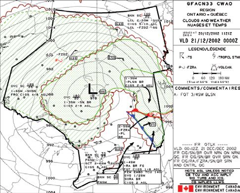
< Previous page                                                                                          Next page >

         TC AIM                                                                                   October 10, 2019

                  TRANSPORT CANADA AERONAUTICAL INFORMATION MANUAL (TC AIM)
                                                    EXPLANATION OF CHANGES
                                                   EFFECTIVE—OCTOBER 10, 2019

          NOTES:
          1. Editorial and format changes were made throughout the
             TC AIM where necessary and those that were deemed
             insignificant in nature were not included in the “Explanation
             of Changes”.
          2. Effective March 31, 2016, licence differences with ICAO
             Annex 1 standards and recommended practices, previously
             located in LRA 1.8 of the TC AIM, have been removed and
             can now be found in AIP Canada (ICAO) GEN 1.7.

          MET
             (1) MET 1.1 General
                 Environment Canada was changed to Environment
                 and Climate Change Canada (ECCC).
             (2) MET 1.1.3 Aviation Weather Services
                 In (c) Other pilot weather services, information was
                 added regarding altimeter settings used as a remote
                 altimeter setting source (RASS) in the USA.
             (3) MET 1.2.3 Weather Services Definitions in Flight
                 Publications
                 The paragraphs (g) ALTIMETER and (h) WIND
                 were added to define the application of “private” for
                 aviation weather services.
             (4) MET 1.3.4 Aerodrome Advisory Forecasts
                 In (a) Offsite, the criteria for an offsite forecast were
                 clarified.
             (5) MET 2.3 Wind Shear (WS)
                 Information on Reactive Wind Shear
                 Systems (RWSs) and Predictive Wind Shear
                 Systems (PWSs) was added.
             (6) MET 8.3 Sample Message
                 In (f) Wind, an additional clause was added on
                 estimated wind.

                         Table of Contents                           Changes    Bookmarks Panel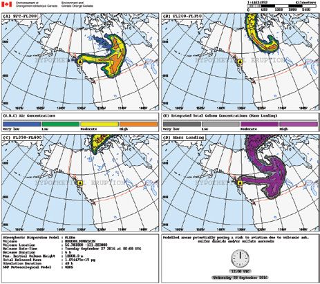
< Previous page Next page >
TC AIM October 10, 2019
Table of Contents
MET—METEOROLOGY 121
1.0 GENERAL INFORMATION .........................................................................................................................121
1.1 General................................................................................................................................................................................................ 121
1.1.1 Meteorological Responsibility......................................................................................................................................... 121
1.1.2 Meteorological Services Available ................................................................................................................................. 121
1.1.3 Aviation Weather Services .............................................................................................................................................. 121
1.1.4 Weather Service Information........................................................................................................................................... 121
1.1.5 Weather Information from Air Traffic Service (ATS).................................................................................................... 122
1.1.6 Pilot Reports..................................................................................................................................................................... 122
1.1.6.1 Pilot Weather Reports (PIREPs)...................................................................................................................................... 122
1.1.7 Applicable International Civil Aviation Organization (ICAO) and World Meteorological ................................................
Organization (WMO) Documents................................................................................................................................... 122
1.1.8 Differences from International Civil Aviation Organization (ICAO) Annex 3............................................................. 123
1.1.9 Pilot Responsibility.......................................................................................................................................................... 123
1.2 Meteorological Observation and Reports ................................................................................................................................................. 123
1.2.1 Type and Frequency of Observations .............................................................................................................................. 123
1.2.2 Flight Weather Documentation ....................................................................................................................................... 123
1.2.3 Weather Services Definitions in Flight Publications ..................................................................................................... 123
1.2.4 Automated Weather Observation Systems (AWOS)....................................................................................................... 124
1.2.4.1 Overview........................................................................................................................................................................... 124
1.2.4.2 Visual Flight Rules (VFR) Weather Stations.................................................................................................................. 124
1.2.5 Automatic Aerodrome Routine Meteorological Reports (METAR AUTO) and Limited Weather Information ...............
System (LWIS) Reports.................................................................................................................................................... 124
1.2.5.1 Automatic Aerodrome Routine Meteorological Reports (METAR AUTO) ................................................................. 124
1.2.5.2 Limited Weather Information System (LWIS) Reports ................................................................................................. 125
1.2.6 Automatic (AUTO) Reports............................................................................................................................................. 125
1.2.7 Weather Services in Support of Approach Unicom (AU)............................................................................................... 125
1.2.8 Runway Visibility Assessment........................................................................................................................................ 125
1.3 Meteorological Forecasts and Charts.............................................................................................................................................. 126
1.3.1 Flight Information Centre (FIC) Hours of Service and Telephone Numbers................................................................. 126
1.3.2 World Area Forecast System (WAFS) Charts ....................................................................................................................... 126
1.3.3 Aerodrome Forecasts (TAFs) .......................................................................................................................................... 126
1.3.4 Aerodrome Advisory Forecasts ...................................................................................................................................... 126
1.3.5 Coastal Weather................................................................................................................................................................ 126
1.3.6 Graphic Area Forecasts (GFAs) and AIRMET................................................................................................................ 126
1.3.7 Upper Level Wind and Temperature Forecasts (FD) ...................................................................................................................126
1.3.8 Air Traffic Control (ATC) Weather Assistance .............................................................................................................. 127
1.3.9 Supplementary Information ............................................................................................................................................ 127
1.3.9.1 Weather Radar ................................................................................................................................................................. 127
1.3.9.2 ECCC/DND Weather Radar Network............................................................................................................................. 128
1.4 In-Flight Meteorological Information (VOLMET)....................................................................................................................... 128
2.0 PILOT WEATHER REPORTS (PIREPs).....................................................................................................128
2.1 General ............................................................................................................................................................................................... 128
2.1.1 Pilot Weather Report (PIREP) Example.......................................................................................................................... 129
2.2 Clear Air Turbulence (CAT)............................................................................................................................................................ 129
2.2.1 General.............................................................................................................................................................................. 129
2.2.2 Turbulence Reporting Criteria......................................................................................................................................... 129
2.3 Wind Shear (WS) .............................................................................................................................................................................. 130
2.4 Airframe Icing ................................................................................................................................................................................... 130
2.5 Volcanic Ash ...................................................................................................................................................................................... 131
2.6 Pilot Estimation of Surface Wind ................................................................................................................................................... 131
3.0 CANADIAN WEATHER INFORMATION..................................................................................................133
3.1 Aviation Forecasts and Charts......................................................................................................................................................... 133
3.2 Aviation Weather Reports ............................................................................................................................................................... 134
3.3 Weather Charts ................................................................................................................................................................................. 135
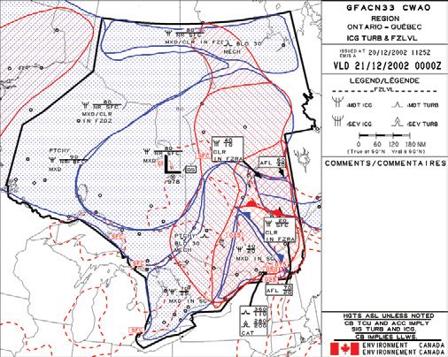
4.0 GRAPHIC AREA FORECASTS (GFA) ........................................................................................................135
4.1 General ............................................................................................................................................................................................... 135
4.2 Issue and Valid Times ....................................................................................................................................................................... 135
Table of Contents Changes Bookmarks Panel i< Previous page Next page >
TC AIM October 10, 2019
4.3 Coverage Area.................................................................................................................................................................................... 135
4.4 Units of Measure ............................................................................................................................................................................... 136
4.5 Abbreviations and Symbols ............................................................................................................................................................. 136
4.6 Layout ................................................................................................................................................................................................. 136
4.7 Title Box ............................................................................................................................................................................................. 136
4.8 Legend Box......................................................................................................................................................................................... 136
4.9 Comments Box.................................................................................................................................................................................... 136
4.10 Weather Information ........................................................................................................................................................................ 137
4.11 Clouds and Weather Chart............................................................................................................................................................... 137
4.12 Icing, Turbulence and Freezing Level Chart................................................................................................................................. 140
4.13 Graphic Area Forecast (GFA) Amendments ................................................................................................................................. 142
4.14 Graphic Area Forecast (GFA) Corrections ................................................................................................................................... 142
5.0 AIRMETs ..........................................................................................................................................................142
5.1 Definition............................................................................................................................................................................................. 142
5.2 Issuance Criteria ............................................................................................................................................................................... 142
5.3 Coordinate Points.............................................................................................................................................................................. 143
5.4 Rules for the Use of Letters.............................................................................................................................................................. 143
5.5 Rules for the Use of Numbers........................................................................................................................................................... 143
5.6 Validity................................................................................................................................................................................................ 144
5.7 Location of the Phenomenon............................................................................................................................................................ 144
5.7.1 Circle................................................................................................................................................................................. 144
5.7.2 Line................................................................................................................................................................................... 144
5.7.3 Polygon.............................................................................................................................................................................. 144
5.8 Flight Level and Extent..................................................................................................................................................................... 144
5.9 Movement or Expected Movement.................................................................................................................................................. 145
5.10 Change in Intensity............................................................................................................................................................................ 145
5.11 Remark ............................................................................................................................................................................................... 145
5.12 Updated AIRMET............................................................................................................................................................................. 145
5.13 Cancellation........................................................................................................................................................................................ 145
5.14 Test AIRMET..................................................................................................................................................................................... 145
5.15 AIRMET Identifiers.......................................................................................................................................................................... 145
5.16 AIRMET Examples........................................................................................................................................................................... 146
6.0 SIGNIFICANT METEOROLOGICAL INFORMATION (SIGMET).......................................................147
6.1 Definition............................................................................................................................................................................................. 147
6.2 Issuance Criteria................................................................................................................................................................................ 147
6.3 Coordinate Points.............................................................................................................................................................................. 147
6.4 Rules for the Use of Letters.............................................................................................................................................................. 147
6.5 Rules for the Use of Numbers........................................................................................................................................................... 148
6.6 Validity................................................................................................................................................................................................ 148
6.7 Location of the Phenomenon............................................................................................................................................................ 148
6.7.1 Circle................................................................................................................................................................................. 148
6.7.2 Line................................................................................................................................................................................... 148
6.7.3 Polygon.............................................................................................................................................................................. 148
6.8 Flight Level and Extent..................................................................................................................................................................... 149
6.9 Movement or Expected Movement.................................................................................................................................................. 149
6.10 Change in Intensity............................................................................................................................................................................ 149
6.11 Remark................................................................................................................................................................................................ 149
6.12 Updated Significant Meteorological Information (SIGMET)...................................................................................................... 149
6.13 Cancellation........................................................................................................................................................................................ 149
6.14 Test Significant Meteorological Information (SIGMET) Message.............................................................................................. 149
6.15 Significant Meteorological Information (SIGMET) Message Identifiers................................................................................... 150
6.16 Significant Meteorological Information (SIGMET) Message Examples..................................................................................... 150
7.0 AERODROME FORECASTS (TAFs)............................................................................................................152
7.1 Aerodrome Forecast (TAF) Locations .......................................................................................................................................... 152
7.2 General................................................................................................................................................................................................ 153
7.3 National Variations............................................................................................................................................................................ 153
7.4 Sample Message................................................................................................................................................................................. 153
7.5 Aerodrome Forecasts (TAFs) from Automatic Aerodrome Routine Meteorological Reports (METAR AUTO) ................ 156
7.6 Amended Aerodrome Forecast (TAF)............................................................................................................................................. 156
8.0 AERODROME ROUTINE METEOROLOGICAL REPORTS (METARs) ............................................157
ii Table of Contents Changes Bookmarks Panel< Previous page Next page >
TC AIM October 10, 2019
8.1 The Aerodrome Routine Meteorological Report (METAR) Code ............................................................................................. 157
8.2 National Variations ........................................................................................................................................................................... 157
8.3 Sample Message ................................................................................................................................................................................ 157
8.4 Aerodrome Special Meteorological Reports (SPECI) .................................................................................................................. 161
8.4.1 Criteria for Taking Aerodrome Special Meteorological Reports (SPECI) .................................................................... 161
8.4.2 Local Criteria ................................................................................................................................................................... 162
8.4.2.1 Observer’s Initiative ........................................................................................................................................................ 162
8.4.2.2 Check Observations ......................................................................................................................................................... 162
8.5 Automatic Aerodrome Routine Meteorological Reports (METAR AUTO) and Limited Weather Information
System (LWIS) Reports.................................................................................................................................................................... 162
8.5.1 Automatic Aerodrome Routine Meteorological Reports (METAR AUTO) ................................................................. 162
8.5.2 Limited Weather Information System (LWIS) Reports.................................................................................................. 163
8.5.3 Automated Weather Observation System (AWOS) and Limited Weather Information System (LWIS) Performance .....
Characteristics.................................................................................................................................................................. 163
8.5.4 Automatic Aerodrome Routine Meteorological Reports (METAR AUTO) and Human Observation Comparison.... 164
8.6 Voice Generation Systems................................................................................................................................................................. 166
9.0 UPPER LEVEL WINDS AND TEMPERATURES.....................................................................................167
9.1 Canadian Forecast Winds and Temperatures Aloft Network...................................................................................................... 167
9.2 Upper Level Wind and Temperature Forecasts (FDs) ................................................................................................................. 167
10.0 SURFACE WEATHER MAPS........................................................................................................................168
11.0 UPPER LEVEL CHARTS ..............................................................................................................................169
11.1 Upper Level Analysis Charts............................................................................................................................................................ 169
11.2 Upper Level Prognostic Charts ....................................................................................................................................................... 169
12.0 SIGNIFICANT WEATHER PROGNOSTIC CHARTS .............................................................................170
12.1 Lower-Level Charts........................................................................................................................................................................... 170
12.2 High-Level Charts............................................................................................................................................................................. 171
13.0 VOLCANIC ASH PRODUCTS ......................................................................................................................173
14.0 ABBREVIATIONS—AVIATION FORECASTS .........................................................................................175
Table of Contents Changes Bookmarks Panel iii< Previous page Next page >
TC AIM October 10, 2019
MET—METEOROLOGY E-mail: ...........................................service@navcanada.ca
Enquiries relating to regulations and standards for
aviation weather services should be addressed to:
1.0 GENERAL INFORMATION
Flight Standards (AARTA)
Transport Canada
1.1 General Ottawa ON K1A 0N8
The Minister of Transport is responsible for the development Tel.:............................................................ 1-800-305-2059
and regulation of aeronautics and the supervision of all Fax: ...............................................................613-957-4208
matters connected with aeronautics. E-mail:.. TC.Flights.Standards-Normesdevol.TC@tc.gc.ca
The responsibility for the provision of aviation weather
services in Canadian airspace, and any other airspace in 1.1.2 Meteorological Services Available
which Canada accepts the responsibility for the provision Aviation weather information is available from
of air traffic control (ATC) services, has been designated to NAV CANADA FICs. Telephone numbers and hours of
NAV CANADA by the Minister of Transport. service are listed in the CFS and the CWAS.
NAV CANADA is responsible for a range of aviation weather 1.1.3 Aviation Weather Services
services, some of which are provided to it under a contractual
agreement with Environment and Climate Change Canada (a) Pilot briefing service—The pilot briefing service is
(ECCC). These services include most civilian aviation weather provided by NAV CANADA FICs to accommodate
forecasts. NAV CANADA is responsible for determining the pilots at the pre-flight planning stage and for information
location and frequency of aviation weather observations and updates while en route. Flight service specialists can
forecasts, and for the dissemination of this information for access and display a full range of weather charts, imagery
aviation purposes. (e.g. satellite, lightning and radar) and aeronautical
information (such as NOTAM, RSC and CRFI). They
In addition to the aviation weather services provided by are qualified to provide briefings, consultation and
NAV CANADA, other aviation service providers may offer advice, and to interpret meteorological information. (See
MET
weather services in support of operations at local aerodromes RAC 3.2 for details).
that have light traffic, are private, and/or are used primarily (b) Aviation weather web site (AWWS)—NAV CANADA’s
in support of private industry, such as mining or other aviation weather web site (AWWS), available
similar operations. at , and
collaborative flight planning system, available at
The Department of National Defence (DND) arranges for the , offer aviation weather
provision of aviation weather services at military aerodromes. products, NOTAM and the ability to file flight plans.
For more information, visit .
1.1.1 Meteorological Responsibility Pilots operating near the border should note that U.S.
METAR, SPECI and TAF must be obtained through
In accordance with CAR 804.01(1) the majority of standards the Aviation Digital Data Service (ADDS), available at
for aviation weather services are found in: ICAO Annex 3, .
the Manual of Standards and Procedures for Aviation (c) Other pilot weather services—In accordance with an
Weather Forecasts (MANAIR), and the Manual of Surface arrangement with the U.S. National Weather Service,
Weather Observations (MANOBS). The two manuals can be digital upper level wind and temperature forecasts
obtained from ECCC’s Web site at , while Annex 3 can be obtained from to the Gander OAC for planning transatlantic flights.
ICAO. An updated eighth edition of MANOBS took effect in Aviation weather flight documentation is provided,
February 2019. subject to prior notification, as determined by the local
weather service outlet in consultation with the operator’s
Enquiries relating to the provision of aviation weather services local representative. Operators are responsible for
should be addressed to: notifying NAV CANADA’s aviation weather services
NAV CANADA of new requirements. (See MET 1.1.1 for the address.)
Aviation Weather Services Where indicated in the CAP, altimeter settings in weather
77 Metcalfe Street reports from U.S. aerodromes may be used as a RASS.
Ottawa ON K1P 5L6
Tel. (toll-free in North America): ..............1-800-876-4693
1.1.4 Weather Service Information
Fax: ............................................................... 613-563-3426 When planning a flight, pilots can obtain aviation weather
Fax (toll-free in North America): ............. 1-877-663-6656 and aeronautical information and file a flight plan through a
Table of Contents Changes Bookmarks Panel 121< Previous page Next page >
TC AIM October 10, 2019
NAV CANADA FIC. (See RAC 3.2 for details). “UACN10” for normal PIREPs and “UACN01” or “UUA”
for urgent PIREPs. A suggested format for PIREPs can be
Radio communication should be established with a FIC on a found on the back covers of the CFS and the CWAS. More
FISE frequency if in-flight information is required to assist in information on PIREPs can be found in MET 2.0.
making a decision or to terminate a flight, or to alter course
before adverse weather conditions are encountered. 1.1.6.2 Air Reports (AIREPs)
Pilot requests for initial pilot briefings while airborne are not AIREPs are appended to the routine position reports of some
encouraged because this practice leads to frequency congestion. flights as follows:
1.1.5 Weather Information from Air Traffic (a) international air carrier aircraft transiting Canadian
domestic FIRs north of 60˚N and east of 80˚W, and north
Service (ATS)
of 55˚N and west of 80˚W should use the AIREP format
All aerodromes with operational ATS will provide, on and report routine meteorological observations to Gander
initial contact or as soon as practicable, the current wind Radio at each designated reporting point or line;
and altimeter information unless it is known that the aircraft
already has this information. ATS procedures require that (b) all aircraft operating in the Gander OCA should use
wind information be transmitted with landing and take-off the AIREP format and report routine meteorological
clearance only when the wind speed is 15 kt or greater. Wind observations at each designated reporting point or line.
velocity (direction and speed) data is typically updated every The exception is that aircraft cleared on a designated
five seconds using a running 2-min average. Variations to the NAT track will give these reports only if the phrase
wind speed (gusts) and/or wind direction are based on wind “SEND MET REPORTS” is included in their oceanic
data from the previous 10 min. clearance.
At aerodromes with an operational ATIS, the full details of There are no special requirements for transmitting AIREPs
the most recent METAR or SPECI will be included in the with appended meteorological information other than those
recorded message. In rare circumstances, such as during specified in ICAO’s Regional Supplementary Procedures
rapidly changing weather conditions, this information will (Doc 7030).
MET
be provided directly by ATS. Where ATIS is not operational,
updated current information about weather elements from 1.1.7 Applicable International Civil Aviation
METAR/SPECI is available on request.
Organization (ICAO) and World
RVR observations are obtained by transmissometers and
Meteorological Organization (WMO)
forward-scatter sensors. Observations representative of Documents
the touchdown and, where available, midpoint and roll out Whereas ICAO determines the standards and recommended
visibility, averaged over 1 min and based on the light setting practices with respect to meteorological service for
in use, are automatically displayed in digital form in the international air navigation, the WMO determines and
local ATS unit. reports the internationally agreed upon code formats for the
reports and forecasts. ICAO and WMO documents applicable
RVR is included in METARs and SPECIs when it is 6 000 ft to aviation meteorology are as follows:
or less for the runway in use and/or the visibility is 1 SM or
less. The RVR is presented in ICAO format and is based on a (a) ICAO Annex 3—Meteorological Service for
10-min average of the maximum runway light setting. Refer International Air Navigation
to the METAR example in MET 8.3 for further details.
(b) WMO Doc 306—Manual on Codes
1.1.6 Pilot Reports
WMO documents may be ordered directly from the WMO
Secretariat in Geneva, Switzerland. ICAO documents may
1.1.6.1 Pilot Weather Reports (PIREPs) be purchased from ICAO Headquarters in Montréal. The two
Pilots are urged to volunteer reports of cloud tops, upper relevant addresses are listed below:
cloud layers, cruising level wind velocity, and other
meteorological information which may be significant to safe World Meteorological Organization (WMO)
or comfortable flight conditions. The information is also Sales and Distribution of Publications
used by ECCC meteorologists to confirm or amend aviation 7bis, avenue de la Paix
weather forecasts. PIREPs less than one hour old that contain P.O. Box 2300
information about conditions considered to be a hazard to CH-1211 Geneva 2, Switzerland
aviation are broadcast immediately to aircraft in the affected
area and will be included in subsequent scheduled weather Tel.: .......................................................... +41-22-730-8111
broadcasts. PIREPs are also transmitted under the headings Fax.: ......................................................... +41-22-730-8181
122 Table of Contents Changes Bookmarks Panel< Previous page Next page >
TC AIM October 10, 2019
Web site:....................................................... www.wmo.int SPECIs, PIREPs, and upper wind and temperature forecasts.
International Civil Aviation Organization (ICAO) There are two distinct methods of reporting cloud bases. It
Distribution Sales Unit is vital for the pilot to be able to distinguish and recognize
Suite 305 which method of reporting is in use. Heights in METARs
999 Robert-Bourassa Boulevard and TAFs are always stated as height above ground level. On
Montréal QC H3C 5H7 the other hand, heights in GFAs and PIREPs are normally
stated as height above sea level, since terrain heights are
Tel.:................................................................514-954-8022
variable over the larger area covered. If heights are not ASL
Web site:........................................................ www.icao.int
in GFAs, this is always highlighted by statements such as
Pilots flying outside of North America should consult the “CIGS 2-4 AGL”.
differences filed by other member states as outlined in
WMO Doc 306 or in the AIP of each country. 1.2.3 Weather Services Definitions in Flight
Publications
1.1.8 Differences from International Civil
The terminology used in the CFS and the CAP to describe
Aviation Organization (ICAO) Annex 3
aviation weather services is as follows:
CAR 804.01(1)(a) incorporates standards contained in
ICAO Annex 3. The current version of Annex 3 includes (a) METAR—METAR and SPECI weather observations
Amendment 78, which will be superseded by Amendment 79 taken by a qualified human observer.
on November 5, 2020. In accordance with CAR 800.01(2),
the incorporation of Annex 3 as a standard “includes the (b) METAR AUTO—METAR and SPECI weather
differences notified to ICAO by the Government of Canada observations taken by a stand-alone AWOS with noted
in respect of the standards specified in that annex”. The enhancements (see MET 8.5). AWOS located outside
full details of these state differences are included in the of the CLDN coverage area do not receive lightning
AIP Canada (ICAO), as published and disseminated by data and therefore are unable to report thunderstorm or
NAV CANADA. lightning activity.
MET
1.1.9 Pilot Responsibility Examples of METAR AUTO stations are the
NAV CANADA AWOS and DND AWOS.
Pilots must be aware of the requirements of CAR 602.72: “The
pilot-in-command of an aircraft shall, before commencing a (c) LWIS—An automated weather system which produces an
flight, be familiar with the available weather information that hourly LWIS report containing wind speed and direction;
is appropriate to the intended flight.” temperature; dew point; and altimeter setting only.
(d) AUTO—An automated weather system that does not
1.2 Meteorological Observation and Reports meet requirements to produce a METAR AUTO,
SPECI AUTO or LWIS report. These systems can
1.2.1 Type and Frequency of Observations report a variety of observed weather elements. Contact
the aerodrome operator for further information on the
METARs are coded weather observations that are taken every specifics of the system. Some of these systems may have
hour on the hour at over 200 aerodromes and other locations associated VHF transmissions of their reports as stated
in Canada. In addition, SPECIs are issued whenever weather in the CAP or CFS.
conditions cross specified criteria. For details on how to
understand METARs, see MET 8.3. For details on SPECI (e) WxCam—Indicates that a NAV CANADA aviation
criteria, see MET 8.4. weather camera is installed at the site. Still images are
transmitted to the NAV CANADA AWWS at 10-min
The location of transmissometers or forward scatter sensors intervals.
used to determine RVR is specified on CAP aerodrome charts.
(f) Webcam—Indicates that one or more cameras not
1.2.2 Flight Weather Documentation belonging to NAV CANADA have been installed at this
location. Contact the aerodrome operator for further
Pilots must use the most recent weather information available information on the specifics of the camera system.
when flight planning and be aware of scheduled weather
information updates. Pilots must also remain vigilant for (g) ALTIMETER—Altimeter setting report observed from
pertinent unscheduled weather updates or amendments. two aircraft altimeters. The private altimeter setting
report is a weather service provided in support of an AU.
Flight weather documentation should include, as appropriate: Contact the aerodrome operator for further information
the relevant GFAs, AIRMETs, SIGMETs, TAFs, METARs, on the service.
Table of Contents Changes Bookmarks Panel 123< Previous page Next page >
TC AIM October 10, 2019
(h) WIND—Human assessment of wind speed and direction. NOTE:
The private wind speed and direction report is a weather The United States uses the term “automated surface
service provided in support of an AU. Contact the observation system” (ASOS) as the equivalent to Canadian
aerodrome operator for further information on the AWOS that provide METAR AUTO reports. Typically, usage
service. of the term AWOS in the United States is equivalent to the
Canadian LWIS but with several defined levels of observation
Observed weather information, observations, and forecasts capabilities. Further details regarding performance
originating from any non-NAV CANADA weather service, characteristics and reporting practices can be found in the
other than DND, are considered a private meteorological FAA’s Aeronautical Information Manual.
service.
1.2.4.2 Visual Flight Rules (VFR) Weather Stations
Stand-alone METAR AUTO and LWIS reports are available
during published hours through normal meteorological Some weather stations are intended exclusively for local use by
information systems. At some sites an automated voice VFR operators. These stations do not meet the requirements
broadcast of the latest observation is available via VHF of a usable altimeter setting or of wind reports for IFR
transmitter. In these cases, the frequency is displayed in procedures. These stations are not permitted at aerodromes
the COMM entry of the CFS Aerodrome/Facility Directory that have IAPs and they are not published in the CFS. Pilots
(e.g. COMM AWOS 124.7, COMM AUTO 122.025). making use of these stations do so at their discretion for VFR.
If the reports from such stations are being broadcast as an
The hours of coverage for METAR, METAR AUTO, and advisory, the frequency will be mentioned in the COMM
LWIS reports are given (e.g. METAR 09-21Z). At sites entry of the CFS Aerodrome/Facility Directory along with an
where coverage is 24 hr/day, the coverage is listed as H24 annotation stating that the reports cannot be used for IFR.
(e.g. METAR H24, METAR AUTO H24, LWIS H24). Pilots should contact the aerodrome operator if they require
additional information.
Sites that provide unspecified limited hours of coverage will
be listed as ltd hrs (e.g. ALTIMETER ltd hrs). Contact the 1.2.5 Automatic Aerodrome Routine
aerodrome operator for further information on the hours of
Meteorological Reports (METAR AUTO)
operation.
MET
and Limited Weather Information
System (LWIS) Reports
1.2.4 Automated Weather Observation
Systems (AWOS)
1.2.5.1 Automatic Aerodrome Routine Meteorological
Reports (METAR AUTO)
1.2.4.1 Overview
AWOS, LWIS and AUTO refer to automated equipment METAR AUTO reports are based on NAV CANADA or DND
used as a means to provide an aviation weather service. The AWOS systems, which are comprised of a set of meteorological
services that can be provided by these systems are either full sensors, a data processing system, a communications system,
METAR AUTO/SPECI AUTO or some subset thereof. LWIS and an optional VGSS and VHF transmitter. In addition,
provides a basic group of four elements and issues an hourly weather cameras are installed at most of these locations.
report. Operators of automated weather stations that are METAR AUTO reports may be used to support a TAF at the
used to support instrument flight procedures are required to associated aerodrome.
document the characteristics of their systems and to provide
aircraft operators with suitable descriptions, upon request. METAR AUTO reports depend on either a NAV CANADA-
or DND-developed system or on a commercial system that
AWOS and LWIS operated by NAV CANADA have common complies with TC requirements for aviation use. Pending
performance characteristics across the country. A description revisions to the CARs, the current standards for the operation
of the performance characteristics of these systems can be of automatic weather stations for aviation use are contained
found in MET 8.5. in a global exemption to CAR 804.01. Full details on this
exemption are available on the TC Web site or from TC
The subset of weather elements provided by AUTO may regional offices.
vary from only one element to almost a full METAR AUTO/
SPECI AUTO. Any automated system that is not capable of Observations are distributed in the form of METAR AUTO
reporting all the elements required to generate METAR AUTO/ reports and must be properly coded and supplemented by
SPECI AUTO reports and support any associated TAF SPECI AUTO reports when SPECI thresholds are crossed. At
should be referred to as AUTO or LWIS. Some local service a minimum, the following are observed and reported:
providers may refer to their systems as AWOS, but if they do
not support METAR AUTO/SPECI AUTO, then they will be (a) wind (direction, speed and gusts);
listed as AUTO in the CFS.
(b) altimeter setting (these include multiple sensors as a
124 Table of Contents Changes Bookmarks Panel< Previous page Next page >
TC AIM October 10, 2019
fail-safe ); reports fewer elements than the standard four required for an
LWIS should be referred to as an AUTO. For more information
(c) air temperature; on LWIS, please refer to MET 8.5.
(d) dew point; 1.2.6 Automatic (AUTO) Reports
(e) visibility; The term AUTO is used to describe all other automated
aviation weather reports that have demonstrated compliance
(f) cloud height; with TC requirements and are usable for IFR flight. However,
they have a wide variety of performance characteristics and
(g) sky coverage (of detected cloud); may be referred to locally by different labels, most often as
AWOS. Contact the airport operator for more information on
(h) precipitation occurrence and type; the characteristics of local systems.
(i) fog, freezing fog, haze, blowing snow and mist; 1.2.7 Weather Services in Support of Approach
Unicom (AU)
(j) thunderstorm detection capability; and
Weather information is not usable for instrument procedures
(k) icing. unless it complies with the requirements of CAR 804 or a
related national exemption.
In addition, reports may include RVR when required.
AU is an air-ground communications service that can provide
For more information on METAR AUTO reports, refer to approach and landing information to IFR pilots. The altimeter
MET 8.5. setting and wind reports provided by an AU are usable in
support of an instrument procedure. Pending revisions to the
1.2.5.2 Limited Weather Information System (LWIS) CARs, these services must be provided by qualified persons
in accordance with one of the two national exemptions to
Reports
CAR 804.01(1)(c) that are in effect for these services.
MET
A LWIS comprises automated meteorological sensors, a data
processing system, a communication system, and an optional The first national exemption establishes how two aircraft
VGSS with a VHF transmitter. The LWIS collects limited altimeters can be used to observe and report a usable altimeter
meteorological data, produces LWIS reports, and transmits setting. The second establishes procedures to follow for the
data to ATS facilities on the hour. The LWIS also transmits human assessment of wind speed and direction, usable for
data updated every minute to the affiliated VGSS and VHF the selection of the most into-wind runway. More details
transmitter units. regarding these exemptions can be found on the TC Web site
or obtained from a TC regional office.
These systems were developed to meet a defined level of service
requirement for NAV CANADA. At a few AU locations, fully automated systems are used to
measure atmospheric pressure. This data is used to determine
Any LWIS used for civil aviation purposes must comply with the altimeter setting that is relayed to pilots. In these cases,
TC requirements, including siting, maintenance, and quality the reported altimeter setting must comply with the same
control, and be equipped with sensors to report, at a minimum, requirements applied to the altimeter component of METAR
the following: AUTO/SPECI AUTO.
(a) wind (direction, speed, and gusts); Any weather information provided by a UNICOM, as opposed
to an AU, is not usable for instrument procedures; alternative
(b) altimeter setting (these include multiple sensors as a fail- uses are entirely at the pilot’s discretion.
safe);
1.2.8 Runway Visibility Assessment
(c) air temperature; and
At aerodromes where RVR is not provided, qualified persons
(d) dew point. may, in accordance with the runway visibility assessment
standards referenced in CAR 804, provide an assessment of
Wind direction is reported in degrees true except for runway visibility. Instrument-rated pilots may also provide
the VGSS, which reports wind direction in degrees magnetic such assessments in accordance with CAR 602.131.
in SDA.
A runway visibility assessment is valid for only 20 min after
Except for the DND stations in the High Arctic that do not it has been established.
provide dew point information, any automated system that
Table of Contents Changes Bookmarks Panel 125< Previous page Next page >
TC AIM October 10, 2019
Coast Guard stations. Frequencies and time of broadcast are
1.3 Meteorological Forecasts and Charts contained in two Canadian Coast Guard Publications: Radio
Aids to Marine Navigation (Pacific and Arctic) and Radio
1.3.1 Flight Information Centre (FIC) Hours of Aids to Marine Navigation (Atlantic, St. Lawrence, Great
Lakes, Lake Winnipeg and Arctic). These two publications are
Service and Telephone Numbers
published annually and are available on the Canadian Coast
All FICs provide 24-hr service. FIC telephone numbers are Guard Web site.
provided in the CFS. Pilots dialing the common toll-free
number 1-866-WXBRIEF (992-7433) will automatically 1.3.6 Graphic Area Forecasts (GFAs) and
be routed to the FIC serving the area from which the call is
AIRMET
being made.
GFAs are issued as a series of temporally adjusted
1.3.2 World Area Forecast System (WAFS) Charts weather charts for CDA and distributed on a rou-
tine or on-request basis. These forecasts are pre-
WAFS aviation weather charts are disseminated as required. pared four times daily for seven regions across the
These include prognostic significant weather charts for the
country with a validity period of 12 hr and an IFR
North Pacific, the Caribbean and northern South America,
the North Atlantic, Canada and the United States. outlook for a further 12 hr. See MET 4.0 for issue,
periods of validity and decoding instructions. Once
1.3.3 Aerodrome Forecasts (TAFs) issued, a SIGMET or AIRMET message automati-
cally amends the current and relevant GFA. A full
TAFs are prepared for approximately 180 aerodromes across
description of AIRMET can be found in MET 5.0.
Canada. TAFs are limited to aerodromes for which METAR
and SPECI reports are available. The forecasts are generally
prepared four times daily with periods of validity up to a 1.3.7 Upper Level Wind and
maximum of 30 hr. See MET 7.0 for more information on Temperature Forecasts (FD)
TAFs, including where and when they are issued, their periods Alphanumeric upper level wind and temperature forecasts (FDs)
of validity and decoding instructions. are routinely prepared for 142 sites in Canada. FD forecasts are
MET
produced by a super-computer model of the atmosphere called
TAFs are issued in TAF code, with amendments as required. a NWP model, which is run twice per day at 00Z and 12Z after
collecting and analyzing weather observation data from around
1.3.4 Aerodrome Advisory Forecasts the world.
Aerodrome advisories are forecasts that are issued in TAF FD forecasts based on the 12Z NWP model run on the fifth
format except that ADVISORY is added immediately after the day of the month would include the following text in front of
period of validity group. They are issued in place of a TAF in the forecast data: “FCST BASED ON 051200 DATA”. The
the following circumstances: text “DATA VALID 060000” in the FD forecast indicates
that the temperature and wind velocity data is forecast to be
(a) Offsite—the forecast is based on observations that have most representative of conditions at 00Z on the sixth day of the
been taken off site, more than 1.6 NM from the aerodrome month. FD forecast data can be used for several hours before or
centre, and are not considered to be representative of after the stated valid time. This is indicated by the text “FOR
weather conditions at the aerodrome; USE” followed by the time range. For example, “FOR USE
21 – 06” means that this particular forecast may be used for a
(b) Observation incomplete—the forecast is based on observa- 9-hr period from 21Z to 06Z.
tions which have regularly missing or incomplete data; or
During flight planning, care must be exercised to ensure
(c) No specials—the forecast is based on observations from that the correct FD forecast is selected and the associated
a station with a limited observing program that does not “FOR USE” coverage is appropriate for the time of the
issue SPECIs. proposed flight.
In each case, after the period of validity group, the advisory Forecasts in digital form of the winds and temperatures aloft
forecast will be labelled with the word ADVISORY and the (FB), an improvement over FD forecasts, are now available
appropriate qualifier (OFFSITE, OBS INCOMPLETE, or over the phone. FB forecasts are updated four times per day.
NO SPECI). Over the next couple of years, FB forecasts will gradually
replace FD forecasts for most flight planning purposes. Further
1.3.5 Coastal Weather information is available in the MANAIR, which can be found
on ECCC’s Web site. Forecasts of upper winds and temperatures
Float plane operators can also obtain coastal marine weather are also available in chart form.
on HF and VHF FM frequencies from some Canadian
126 Table of Contents Changes Bookmarks PanelYou can also read