Developing a Landscape Design Approach for the Sustainable Land Management of Hill Country Farms in New Zealand - MDPI
←
→
Page content transcription
If your browser does not render page correctly, please read the page content below
land
Review
Developing a Landscape Design Approach for the
Sustainable Land Management of Hill Country Farms
in New Zealand
Duy X. Tran *, Diane Pearson , Alan Palmer and David Gray
 School of Agriculture and Environment, College of Sciences, Massey University,
 Palmerston North 4414, New Zealand; D.Pearson@massey.ac.nz (D.P.); A.S.Palmer@massey.ac.nz (A.P.);
 D.I.Gray@massey.ac.nz (D.G.)
 * Correspondence: D.Tran@massey.ac.nz; Tel.: +64-27-270-4426

 Received: 11 May 2020; Accepted: 31 May 2020; Published: 3 June 2020

 Abstract: Landscape modification associated with agricultural intensification has brought
 considerable challenges for the sustainable development of New Zealand hill country farms.
 Addressing these challenges requires an appropriate approach to support farmers and design
 a better landscape that can have beneficial environmental outcomes whilst ensuring continued
 profitability. In this paper we suggest using geodesign and theories drawn from landscape ecology to
 plan and design multifunctional landscapes that offer improved sustainability for hill country farm
 systems and landscapes in New Zealand. This approach suggests that better decisions can be made by
 considering the major landscape services that are, and could be, provided by the landscapes in which
 these farm systems are situated. These important services should be included in future landscape
 design of hill country by creating a patterning and configuration of landscape features that actively
 maintains or restores important landscape functioning. This will help to improve landscape health
 and promote landscape resilience in the face of climate change. Through illustrating the potential of
 this type of approach for wider adoption we believe that the proposed conceptual framework offers a
 valuable reference for sustainable farm system design that can make an important contribution to
 advancing environmental management globally as well as in New Zealand.

 Keywords: multifunctional landscapes; landscape services; geodesign; landscape ecology;
 agricultural landscape planning

1. Introduction
     The green revolution in agriculture that occurred during the second half of the 20th century
has greatly contributed to increased global food and fiber production, which has enabled a rapidly
growing world population to be fed [1]. In order to increase productivity, agricultural intensification
has taken the form of an increase in single crop cultivation and chemical and mechanical inputs [2].
This has led to negative impacts on the environment, evident through a loss of biodiversity and a
decline in soil and water quality [3]. In response to the resultant environmental issues and the need to
feed a growing population, agriculture needs to evolve from a production paradigm that has focused
primarily on productivity and profitability to a more sustainable paradigm that focuses on how to
ensure productivity can support human needs whilst also preserving important land resources and
environmental integrity [4]. Recently, society and the market have initiated a shift from a focus on
agricultural productivity and intensification to a focus on sustainable farming (with an emphasis
towards efficiency, sustainability and resilience) [5]. New Zealand (NZ) is a good example of an
agriculturally-focused nation that faces sustainable production challenges. It has achieved great

Land 2020, 9, 185; doi:10.3390/land9060185                                      www.mdpi.com/journal/land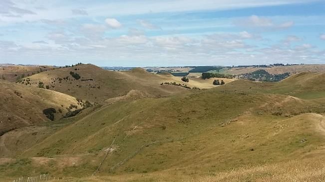
Land 2020, 9, 185                                                                                    2 of 29

improvements in agricultural productivity and product quality over recent decades [6] but progress
has come with significant environmental costs [7].
      Although New Zealand is accredited as one of the more sustainable countries in the world and
was ranked 11th globally in 2019 for sustainable development [8], its agricultural sector is facing a
number of significant issues, such as soil degradation [9], water pollution [10], greenhouse gas (GHGs)
emissions [11,12] and soil erosion [13]. Moreover, the possible impact of climate change (e.g., increased
flood risk, storm damage and drought severity) is also a crucial threat to agricultural production [14].
To respond to these environmental issues farmers are now faced with a situation of having to operate
farm systems that are productive and profitable as well as being sustainable with limited impacts on
the environment [15]. This is a major challenge facing NZ farmers, as agricultural production could
potentially become increasingly constrained by environmental regulations [16] as governments also
respond to growing environmental concerns.
      The environmental challenges facing future farming systems are likely to strongly impact upon NZ
hill country farming. This is because environmental issues compound already high concerns for these
farms, which are associated with the contemporary impacts of increasing production costs, market
volatility, climate change, highly variable topography and climatic conditions, and more dispersed and
isolated families and communities [17]. This means that future hill country farming systems will need
to improve its profitability and build resilience in order to be able to adapt to a changing climate whilst
reducing its impacts on the environment. To do this, farmers will need good support systems to help
with land use decision-making. However, current land use planning and management approaches
that support farm and landscape decision-making in NZ reveal several limitations, such as lack of data
and model transparency, insufficient collaboration capability among researchers, policy-makers and
other end users, and are limited in terms of the communication of modeling results to end-users [18].
Additionally, some land and environmental planning tools are not simple to implement, as farmers
are overwhelmed with information and the process required to develop the land and environmental
plans [19]. Consequently, these limitations will reduce the effectiveness of land and environmental
planning strategies. Therefore, the development of an effective landscape design approach will be
central to helping farmers develop profitable and sustainable farming systems in the future.
      The multiple objectives of sustainable agriculture require a multifunctional agricultural landscape
that promotes agricultural production whilst ensuring environmental standards are met [20],
and landscape ecology can have an important role to play in this [21]. Developing a multi-functional
agriculture landscape that provides multiple landscape services (i.e., ecosystem services) for society
in addition to the service of food and fiber production [22] has become a key focus for sustainable
agricultural research and policy-making, and this has been widely discussed internationally [23–26].
However, there is a gap between theory and practice [27], and transferring the concept of creating
multifunctional landscapes into the practice of landscape planning and management has proved to be
challenging [28]. The reason for this is that agricultural landscape planning needs to be implemented
for a specific geographical region that is strongly associated with local knowledge [29]. This needs the
planning process to involve the considerations of local people and therefore requires participation and
collaboration of the main stakeholders [30]. Often this does not happen and as a result, local people
(or "people of the place") may not agree or may not be able to afford the future landscape scenarios
proposed by landscape planners [31], so it is critical that the relevant different stakeholder groups can
actively contribute to designing the future landscape by bringing their knowledge and aspirations to
the table [32]. It is important that effective landscape planning and scenario development involves an
iterative collaborative process and that a design-driven perspective is taken [33].
      Recently, geodesign has emerged as an efficient instrument for the implementation of sustainable
landscape planning [34]. Geodesign integrates geospatial technologies and scientific methods
(e.g., geospatial science, environmental science) to inform spatial decision-making based on the
knowledge and information obtained from spatial data [35]. By integrating multiple layers of geographic
information and spatial analysis models, geodesign enables the identification and development of a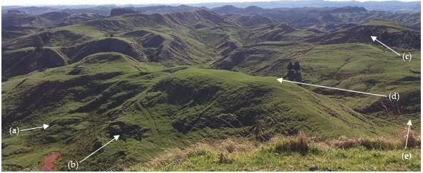
Land 2020, 9, 185                                                                                    3 of 29

future landscape that has an appropriate spatial pattern or configuration of landscape features [36].
This also enables the rapid generation of future landscape scenarios for a study area, the ability
to visualize change scenarios, and the assessment of the impacts of future landscape designs
on multiple landscape functions and services [37]. In addition, visualization tools and iterative
quantitative modeling used in geodesign can promote collaboration between participants, as they
enable stakeholders to enter into the discussion and express their opinions and aspirations as part of
the design procedure [38]. Among the geodesign frameworks that have been published, the operation
framework developed by [31] has been disseminated to a wide range of landscape and environmental
design situations [39]. This framework considers landscape design as an iterative process in which
the collaboration among the group of people involved in the design process (which includes design
professionals, the people of the place, information technologists and geographic scientists) is an integral
part of the design procedure, and the relevant stakeholders play a central role in all of the design
stages [40].
      The adaptation of the framework outlined by Steinitz offers a potential solution to guide farm
system decision-making for the creation of multifunctional landscapes. This paper develops these ideas
by proposing a landscape design approach for the sustainable land use planning and management of
hill country farms in NZ. The approach developed utilizes geodesign and the concepts of landscape
function and services as informed by landscape ecology. The specific objectives of this paper are
to: (i) define the major challenges facing current and future agriculture in the NZ hill country that
need to be considered in future farm landscape planning; and (ii) design a framework that can assist
in the creation of multifunctional landscapes for sustainable agricultural production. In doing this,
the paper highlights the benefits of integrating geodesign into multifunctional landscape planning for
the creation of multifunctional farm landscapes in NZ. This research offers a valuable reference for
sustainable farm system design that can make an important contribution to advancing environmental
management globally as well as in NZ.

2. Multifunctional Landscape and Geodesign

2.1. Multifunctional Landscapes and its Application in Agricultural Landscape Planning
      A multifunctional landscape is seen as being one capable of providing a wide range of landscape
services (i.e., ecosystem services) covering three main areas relevant to landscape management,
i.e., ecological, cultural and production functions [41]. Natural and semi-natural landscapes are
considered as multifunctional landscapes because they provide a variety of goods and services to
people, such as food and fiber, climate regulation and water purification [42]. However, multifunctional
landscapes of the past have been transformed into more simple landscapes (e.g., single-function
landscapes), which have a dominant land use type (e.g., croplands). This is because land managers
and decision-makers have focused on increasing agricultural productivity rather than considering the
benefits that can be provided by a multifunctional landscape [43]. The transformation of a natural
landscape into an agricultural landscape, especially one that is farmed intensively, leads to landscape
simplification. This occurs as diverse stands of native vegetation are cleared and replaced with a
monoculture, resulting in a loss of biodiversity and a reduction in landscape functions and services [44].
Many studies have demonstrated the negative effects of landscape simplification, such as an increase of
insecticide use [45], loss of habitats [46] and a reduction in biological control [47]. As such, developing
a multifunctional landscape is increasingly being recognized as offering an appropriate solution for
solving the issues and challenges that have arisen from agricultural intensification (i.e., landscape
simplification) [20].
      A landscape ecological approach based on the concept of the multifunctional landscape has
been widely applied in sustainable agricultural landscape planning [48–51]. In the European Union
(EU), multifunctional agriculture is significantly encouraged, as it is a key concept of the Common
Agricultural Policy for the EU countries [52]. This concept is also applied in many developed countries,
Land 2020, 9, 185 4 of 29
like the United States of America, Canada and Australia (as cited in [48]). The overall goal of agricultural
landscape planning that is based on the concept of the multifunctional landscape is to develop future
or alternative landscapes that can enhance and increase the multifunctionality of the current landscape,
in order to achieve a better balance between agricultural production and other landscape services [53].
A landscape services approach has been applied in order to examine a wide range of issues in
NZ, such as biological control [54], biodiversity [55] and land use planning and management [56–58].
However, some limitations have been identified, such as the obstacles associated with incorporating the
landscape services concept into agricultural land use decision-making and the lack of participation and
contribution of farmers in the creation of a future multifunctional landscape [59]. Another important
limitation is the inadequacy of the link between landscape service supply and demand. For instance,
there is a lack of research that assesses the imbalance between landscape service supply and non-market
demand in a spatially explicit manner (e.g., where and to what extent in the landscape are certain
services generated by agro-ecosystems needed to maintain desirable environmental conditions) [59].
In addition, current research involves limited measurements of landscape services (e.g., biodiversity)
other than production services (e.g., food and fiber) across small areas (e.g., farm scale) [60]. Therefore,
the ability to fully integrate multiple landscape services into land use planning and the implementation
of a collaborative planning process will provide a greater opportunity to address these gaps.
In this research we have used the terms landscape functions and landscape services instead of
ecosystem functions and ecosystem services. Although these concepts are often used as synonyms, it is
advocated that the use of the terms landscape functions and landscape services is more appropriate,
as these terms are more attractive to people outside the ecological sciences and may be more related to
local people [61]. In addition, landscape functions and services are more appropriate to landscape
planning, which is strongly associated with human involvement, whereas ecosystems are often
perceived as merely natural and semi-natural systems [62].
2.2. Geodesign
Geodesign is defined as “a design and planning method which tightly couples the creation
of design proposals with impact simulations informed by geographic contexts, systems thinking,
and digital technology” [37] (p. 29).
Geodesign often involves collaboration among essential groups (e.g., the design experts,
geographical information system (GIS) scientists, information technologists and the stakeholders) to
develop and decide sustainable scenarios for the future landscape of their area [31]. These groups
comprise a geodesign team, and collaborate based on a set of questions and methods, typically within
a framework that consists of six key questions [63]:
1. How should the landscape be described in content, space and time?
2. How does the landscape operate?
3. Is the current landscape working well?
4. How might the landscape be altered? By what policies and actions, where and when?
5. What differences might the changes cause?
6. How should the landscape be changed?
Six models are employed to answer each of the six questions, ranging from the description of the
study area to the decision on a desired future landscape. The process presented in the framework is
an integrated and continuous procedure, because the outcome of each phase serves as an input for
the subsequent phase, and all the stages of the design (understand study area, specify methods and
perform study) are incorporated into one unified system.
Recently, geodesign has emerged as an innovative design approach, developed to provide
alternative scenarios for future landscapes, based on a rich knowledge base about the environment [35].
Geodesign has been extensively applied to different landscape planning and management case studies,
such as urban development [64–66], environmental management [67,68], and sustainable agriculturalLand 2020, 9, 185 5 of 29
land use [69–71]. This approach is also flexible in terms of the scale of application (e.g., a street,
a farm, small town, catchment and regional scales) [72,73]. Various examples of geodesign applications
were discussed at the Geodesign Summit in 2019 [74]. In the case of agricultural landscape planning,
a typical example of the application of geodesign is illustrated through the use of the approach to
increase food production and biofuel commodities and improve water quality and habitat performance
in the Seven Mile Creek watershed, Minnesota, United States [75]. At the farm scale, another example
is a geodesign project that utilizes 3D modeling and geospatial analysis to design strategies for climate
change mitigation on a farm in Iowa, United States. This project applies geodesign for real-time
scenario development and interactively evaluating alternative farm design [76].
In New Zealand, GIS tools and techniques have been widely applied to solve environmental
problems [77–81], but the tools and approaches that link design and GIS have not been readily
available [82] and there is a limited number of applications that follow the geodesign framework to
solve problems in landscape planning, especially at the farm scale. For instance, only one previous
paper was identified that applied geodesign to plan a route for visitor access across a farm in NZ [83].
Meanwhile, there is an absence of geodesign applications that focus on developing a multifunctional
agricultural landscape. Hence, research that utilizes geodesign procedures in an agricultural landscape,
especially at the farm scale, has the potential to contribute to environmental management studies in
NZ but has not yet been fully explored.
2.3. The Benefits of Integrating Geodesign into Multifunctional Landscape Planning
Geodesign offers an efficient solution to implement the adaptive design of multifunctional
landscape planning. It is an effective approach because it can (1) promote collaborative and adaptive
landscape design among different stakeholders, (2) advance landscape multifunctionality in agricultural
landscape planning and (3) enable the implementation of the landscape design problem on a large
scale. One key advantage of geodesign compared to traditional landscape planning approaches is that
it allows for collaboration among researchers, policy-makers, and other end users, because it divides
the landscape planning into different processes (with six distinct phases) and allows the participants
involved to provide feedback and suggestions at any step in the process [84]. With the latest geospatial
technologies (e.g., WebGIS application, human–computer interaction tools), participants can directly
interact with both the data and the analysis procedure. This is considered an efficient way to initiate
discussion among different stakeholders about alternative futures or visions for the new landscape [85].
In addition, a geodesign framework includes a decision model [63] so this can make the application of
landscape planning more adaptive and practical. It supposes that decision-makers may agree with or
oppose the proposed change, so the decision model that includes a negotiation process (e.g., discussion)
and method (e.g., Delphi method) will be able to effectively build consensus among decision-makers
and other stakeholders, as well as able to suggest necessary modifications to the proposed changes or
the development of new adapted plans [40]. Additionally, alternative landscape plans are not always
going to provide a first and ultimate fix, so decision-makers can iteratively discover the trade-offs and
synergies inherent in different design scenarios until a final decision is achieved [27]. In the case of
NZ, where agricultural land is under private ownership and farmers are the final decision-makers,
the inclusion of a decision model in landscape planning is critical because it increases the role of farmers
in the landscape design process. This can potentially facilitate the approval by private landowners of
proposed landscape change and therefore make the implementation of future landscape change more
feasible [86].
Compared to other landscape design methods and techniques, geodesign has a great potential
to break new grounds in the design industry, as it is based on advanced geospatial technologies [87].
State-of-the-art remote sensing, image processing, and GPS tools and techniques enable the collection
and processing of large amounts of biophysical data in high spatial and temporal resolution. This means
that geodesign can be implemented at various scales [88]. This is an asset in the case of NZ hill
country, where geospatial data, and especially data for farm scale application, is poor. For instance, it isLand 2020, 9, 185 6 of 29
common that there is a lack of detailed land use land cover (LULC) data at the farm scale, so in this case
high-resolution remotely sensed data can be used to produce necessary LULC information. In addition,
a wide range of tools, techniques, and models that have arisen from GIS, geospatial information,
spatial statistics and computer programming can be incorporated into one spatially informed planning
platform so as to allow comprehensive landscape design issues to be resolved (as it is a multidisciplinary
or transdisciplinary problem) and to provide a more efficient communication mechanism for the
modeling processes and results [89]. Geodesign can also integrate different kinds of environmental and
socio-economic models to quantitatively and spatially measure the cost and benefit of implementing
alternative land use scenarios [90]. The outcome from each geodesign question, such as landscape
structure and pattern, environmental sensitivity and risk, and future landscape scenarios, are presented
in a meaningful and intuitive visualization (e.g., dynamic map, table and graph) so as to provide better
assistance for decision-makers. Once the farmers can see the environmental issues on their farms and
measure how much they must invest and can benefit from the future landscape, they will be more
confident to make a decision.
In order to effectively co-design future multifunctional landscapes, non-technical people
(i.e., farmers) may require an understanding of the basic landscape concepts, such as different
socio-economic and ecological landscape functions and services [34]. Through collaboration with other
participants, farmers can receive support from technical people (e.g., scientists) to acquire the necessary
knowledge. More importantly, geodesign employs GIS models, tools and applications to incorporate
numerous layers of geospatial information and transfer the key multifunctional landscape concepts into
realistic visualization forms (e.g., map, graph) [91], as well as to develop future landscape scenarios,
visualize them and analyze the impacts of the different proposed landscapes on multiple landscape
services [37]. This may encourage farmers to pay attention to not only commerce and food production
but also the role of the non-trade functions of agricultural landscapes. In addition, the adaptive design
capability of geodesign enables farmers’ priorities to be considered, as their preferences or requirements
can be set in the land change model and this can subsequently increase the ability to reach a consensus
between farmers and other stakeholders on future multifunctional landscape scenarios.
3. The Case Study
3.1. Introduction to New Zealand Hill Country and its Environmnetal Challenges
New Zealand hill country is defined as land with slopes above 15◦ and located below an altitude of
1000 m above sea level [92]. This landscape type covers a variety of land class types, climatic conditions,
geology, and topography properties [93]. The hill country landscape is a mixture of steeplands, rolling
land and
Land flat
2020, 9, x;land [94]PEER
doi: FOR (Figure 1).
REVIEW 7 of 29
Figure
Figure 1. 1. Hill
Hill countrylandscape:
country landscape:(a)
(a)earth
earth flow;
flow; (b)
(b) slump/earth
slump/earth flow;
flow;(c)
(c)steep slopes> >25°;
steepslopes 25◦(d) flatflat
; (d)
topped
topped ridges;
ridges; (e)(e) hillyslopes
hilly slopes15–25◦ . Photographed
15–25°. Photographed by by Duy
DuyX.
X.Tran
Traninin2019.
2019.
In recent years, hill country farms have become increasingly concerned about environmental
issues [100]. For instance, Beef and Lamb NZ, an industry organization representing NZ's sheep and
beef farmers, has defined four pillars for an environment strategy (created in 2018) for sheep and
cattle farms. These include working towards cleaner freshwater, healthy and productive soils,Land 2020, 9, 185 7 of 29
Most of the hill country is classified as land use capability classes (LUC1 ) 5–7, which are suitable
for pastoral grazing, tree crops or production forestry [95]. Other LUC (e.g., classes 3, 4 and 8) often
occupy a small proportion of hill country land. Overall, approximately 10 million hectares of NZ’s total
land area is classified as hill country (approximately 37.5% of the NZ land surface), with the majority
located in the North Island (6.3 million hectares or 23.5% of NZ’s total area) [96]. Approximately half of
the hill country land (5 million hectares or 18% of NZ’s total area) is allocated to pastoral farmland used
for sheep and cattle farming [97]. It has been reported that sheep and cattle farms, the bulk of which
are located on hill country, also own some 25% of the total native vegetation remaining in NZ [98].
This significant proportion of native vegetation plays an important role in carbon sequestration and
biodiversity conservation [99].
In recent years, hill country farms have become increasingly concerned about environmental
issues [100]. For instance, Beef and Lamb NZ, an industry organization representing NZ’s sheep and
beef farmers, has defined four pillars for an environment strategy (created in 2018) for sheep and
cattle farms. These include working towards cleaner freshwater, healthy and productive soils, thriving
biodiversity and reduced emissions in order to achieve the goal of being carbon neutral by 2050 [98].
However, several environmental problems and the negative effects of climate change are challenging
the sustainable development of this type of farming [17,101].
Understanding the major environmental challenges facing hill country farming is vital to ensure
that good planning for future landscape and farm systems is made for the future. In the following
section, the five major issues that need to be considered prior to landscape planning in order to make
progress towards a more sustainable future for hill country farming are examined in the discussion
below. These are land use change and deforestation, soil erosion, climate change, agricultural
intensification and change in consumers preferences.
Large areas of native forests and shrubland on the steep erodible terrain of NZ hill country
were cleared for pastoral farming by the European settlers [102]. Although limited deforestation has
occurred since the 1980s, the response to historic deforestation and land clearing is still affecting the
current landscape and environment [103]. The negative impact of deforestation has been reflected in a
significant increase in soil erosion [104]. Over the last three decades, reforestation and regenerating of
native vegetation has been increasingly implemented on hill country [105] to reduce sediment loss
from steep slopes into river channels [106] and to increase the capacity for climate change mitigation
and adaptation [107]. Plantation forestry has a number of positive effects on the environment, such as a
reduction in soil erosion and flooding, an increase in carbon sequestration and a reduction in the GHGs
emissions, and it has also reduced pressure on native forests for timber [108]. For instance, a report on
erosion-prone hill country (for the period of 1997 to 2002) reported that the area prone to soil erosion
had been reduced by 36,000 hectares (3% of the total erosion-prone area) due to the planting of exotic
forest or through reversion to native shrublands [104]. However, removal of forest cover at harvest
on steeplands can result in significant environmental impacts, such as landslides, debris flows and
significant impacts on water quality due to sediment loss into waterways [102].
Over the period of 1990–2015, the total area of hill country sheep and beef farms decreased by
approximately 1.3 million ha [100]. This is because the more productive land was converted to dairy
farming or higher-value horticultural crops [97] whilst the steeper, less productive land, which is more
vulnerable to erosion and generates lower financial returns [109], was converted to an alternative land
use, such as forestry, manuka2 for honey production or retirement and a return to native vegetation [17].
Recently, carbon farming, which is a conversion from pasture to forest, is emerging as an alternative
to sheep and beef farming in hill country due to the dramatic increase in the price of carbon credits,
and this conversion can bring high economic profit if this occurs in eligible areas (the land areas where
1 LUC class 1 is flat highly productive land and LUC class 8 is very steep unproductive land.
2 Manuka honey is a monofloral honey produced from the nectar of the manuka, a native tree (Leptospermum scoparium)
that grows in New Zealand and parts of Australia.Land 2020, 9, 185 8 of 29
there has been a net land use conversion to new forests since 1 January 1990) [110]. Therefore, it is
important that relevant scientific information (e.g., mapping of suitable areas for alternative land use
options) is available so as to allow landowners to make appropriate decisions [111].
In the NZ hill country, soil erosion is a critical issue that contributes to land degradation [112].
The hill country has a high level of both natural and human-induced erosion [113] due to the
amalgamation of coarse-textured soils, high slope terrain, high precipitation and agricultural
intensification [114]. Soil erosion presents a significant problem to the practices of current pastoral land,
and it is especially severe on hill country, which has substantial areas of steep slopes and erodible rocks
(e.g., soft rock) [115], especially in combination with high rainfall and high-intensity rainstorms [104].
It is estimated that 192 million tons of soil are lost every year because of erosion and 44% of this takes
place on grassland [116]. Soil erosion does not only represent a reduction in NZ’s natural resources,
but it also results in a decline in soil productivity and a reduction in water quality [113]. In relation to the
economic cost, the effects of soil erosion on hill country can be on-site (e.g., a reduction in productivity)
and off-site (e.g., an increase in flood damage in downstream regions) [95]. The cost of erosion control
and mitigation has often surpassed the value of the production that can be obtained from that land [117],
and an increase in vegetation cover (e.g., regenerating native trees, tree planting and reforestation) has
been described as being the most efficient solution for this problem [118]. For instance, it is argued
that the reforestation of unstable and degraded land can not only effectively control current erosion
problems, but also preclude the formation of new forms of erosion [106]. For these reasons, soil
erosion control is important in land use planning and management in hill country. Characterizing the
detailed spatiotemporal pattern of soil erosion and the capability of landscape options to reduce this
environmental problem are central to managing this issue.
Climate change is recognized as one of the significant challenges facing agricultural development
in NZ hill country [109], as the country’s land-based economy is profoundly reliant on climatic
conditions for the growth of pasture and crops [119]. Increased frequency of intense rainfall events
is a threat to soil erosion, predominantly on hill country steepland [113]. The expected increase in
drought frequency and intensity in some drier regions may severely affect the water supply, agricultural
production and magnitude of wildfire risk [120–123]. Climate change may also directly affect pastoral
production, because the seasonal variation of pasture growth is influenced by rising temperatures, CO2
fertilization and changes in rainfall patterns [119]. Thus, climate change may result in greater variation
in sheep and cattle growth and productivity [124]. Adaptation solutions have been developed to reduce
risks and build resilience to climate change impacts in NZ. Some of the major adaptation strategies put
emphasis on a long-term perspective and suggest an integration of climate change adaptation into the
decision-making process [125].
The impacts of climate change on hill country farming may also be off-site and long-term [126].
For example, climate-concerned international consumers or markets might result in an increased
demand for the outputs from production that has low GHGs emissions [127], which will mean
that NZ agricultural production will have to change accordingly to maintain their market share.
Considerable effort has been made by both the public and private sector to determine climate change
mitigation solutions in NZ, and central to this is to reduce the GHGs emissions caused by agricultural
production [128]. For instance, in the agricultural sector it is suggested that changes to land use and
pasture management will be key solutions for reducing GHGs emissions along with other strategies
(e.g., innovation in animal genetics and breeding) [129]. It is therefore suggested that multiple land use
options (e.g., pasture, forestry, horticulture) need to be considered in relevant areas of the hill country
and the integration of climate change scenarios needs to be made into future land use plans for more
comprehensive land use planning and management models capable of addressing issues related to
climate change.
Intensive pastoral farming in hill country increased rapidly from the late 1940s to early 1980s.
This was due to the increasing demand and rising prices for meat and wool products on the world
market [130]. It was also supported by government subsidies for land development, as well as theLand 2020, 9, 185 9 of 29
emergence of new technological developments (e.g., aerial topdressing—application of aircraft for
fertilizers spreading and pasture seeding) [131]. Intensive farming during this period was reflected
in a re-clearance of a substantial area of native vegetation that was planted in pasture grass for meat
and wool production, an extensive application of fertilizers and agrichemicals, and a high stocking
rate [132]. Agricultural intensification and inappropriate agricultural practices in the hill country have
resulted in negative impacts on the environment. This includes an increase in soil erosion on steeplands
where native bush and shrubs were cleared for pasture, a decrease in biodiversity [133], an increase of
nutrient leaching [134], a reduction in water quality [135] and a reduction of future carbon stocks [136].
Since 1984, hill country farming has undergone a dramatic reduction in sheep numbers, as more
productive pastoral land was converted to other land use types, and farmers also reduced the
stocking rate [130]. Recently, sustainable practices such as organic farming have also been increasingly
implemented on some NZ hill country farms [137]. These sorts of changes have resulted in both
productivity improvement and better environmental outcomes [138,139]. However, despite these
successes, some hill country farms have been managed intensively to improve economic profitability
and unsuitable agricultural practices are still happening [140,141]. For example, farmers tend to
eliminate the reinvading bush, shrubs and exotic weeds in some high-altitude farms, or marginal land
is not fenced off, and this limits the restoration of native forest, which can cause problems associated
with soil erosion as well as reducing future carbon stocks [136].
With increasing concerns about the environmental impacts of agricultural intensification and
the need to mitigate the impacts of climate change, it is necessary to promote a wider uptake of
more sustainable agricultural practices in the hill country [131,142]. Several studies have shown that
applying appropriate farming practices, such as developing shelterbelts and hedges, using native
plants, or riparian plantings can significantly enhance the provision of landscape services (e.g., increase
biodiversity, pest control, water purification) [143–146]. Moreover, by applying appropriate land
management decisions it is possible to increase farm productivity whist reducing the impacts on the
environment [147]. For instance, using soil data, topographic maps and spatial analysis can help to
determine optimum fertilizer application to the appropriate areas and assist in the reduction of nitrate
runoff [148]. Making informed decisions requires good land use planning and management tools,
which can provide detailed land use and environmental information at the farm scale.
Meat and fiber from NZ hill country farms are well recognized on the world market because they
are safe, nutritious and grass-fed [109]. However, international consumers are increasingly becoming
aware of environmental issues that arise from intensive agricultural production and are requesting
more eco-friendly agricultural products or products that respect environmental standards [149,150].
Therefore, the way food is produced (i.e., considering factors such as environmental impact, animal
welfare and carbon footprint) is becoming an important focus of consumer preference that now needs
to be considered alongside the more traditional values associated with high quality [109]. Subsequently,
environmental and sustainability standards are being added to the traditional quality and health
standard requirements for produce. As a result of changes in consumers’ preferences, NZ hill country
farmers are required to adopt more sustainable farming systems that take into account the impact of
their practices on the environment [151,152]. Adopting more sustainable farming practices will not
only improve the environmental health of NZ hill country; it also presents an opportunity for farmers
to capitalize on the growing market for environmentally-friendly products. The utilization of effective
tools for land use planning and appropriate resource allocation will contribute to solving many of the
issues faced by NZ’s hill country.
3.2. Tools and Approaches for Supporting Sustainable Land Use Planning used in New Zealand
Government organizations, research institutions and the private sector have developed a wide
range of land use models and tools to help to address some of the impacts associated with land
use issues and environmental concerns in NZ [153] as well as supporting farm and landscape
decision-making in hill country [154]. Various types of models have enabled the user to deal withLand 2020, 9, 185 10 of 29
specific environmental concerns, such as carbon sequestration [155], greenhouse gas emissions [12],
soil erosion [156], nutrient loss [157] or water use [158]. There are also various applications to help
farmers deal with the issues of farm production: AgInform [159], BiomeBGC [160], MitAgator [161]
and Farmax [162]. There are more complex land use models (e.g., Agent-Based Rural Land Use New
Zealand (ARLUNZ) [163], New Zealand Forest and Agriculture Regional Model (NZ-FARM) [164],
Waikato Integrated Scenario Explorer (WISE) [101]), which can take into account different factors,
such as land use information, socio-economic conditions and environmental parameters (climate, water
quality and biodiversity) to provide projected outcomes for land use and environmental, economic and
demographic indicators.There are also Whole Farm Plans (WFP), which are a long-established land
management tool that is being widely used across NZ to deal with both economic considerations and
environmental constraints on farming systems [165]. Recently, the Land and Environment Plan (LEP)
was developed by Beef and Lamb NZ to support sheep and beef farmers to have a better understanding
about the land and environmental issues that exist on their farms so that they can develop a land use
and environment plan to manage these issues [154].
Land use and environmental planning tools and models have contributed significantly to
agricultural development as well as supporting farmers in decision-making to address sustainability
issues in NZ [18]. However, several improvements are required to increase the effectiveness of the
model outcomes. A review conducted by Motu Economic and Public Policy Research in 2018 [18]
pointed out some gaps that NZ land use modeling needs to take into account in order to improve
its usability. These include increasing the reliability of the data and increasing model transparency,
improving collaboration capability among researchers, policy-makers and other end-users, enhancing
the communication associated with the model results to stakeholders and enabling a climate change
mitigation framework in the land use planning process [18].
Of upmost importance for improving model reliability is the use of data with a better spatial and
temporal resolution. It was conceded that NZ lacks good GIS data when compared to many other
developed countries [18]. Using data that are too generalized means that it is not possible to achieve
accurate analysis, especially at the finer scales (e.g., farm and paddock) [166], as it will fail to capture
the variability present at the a farm scale in relation to factors such as variations in slope, soil types,
soil fertility and effective rainfall [97]. Therefore, it is important to consider acquiring better data at
a high resolution so that land use optimization models can adequately represent the environmental
and ecosystem services variability within small farm-scale areas [59]. It is also important to have an
appropriate amount of time-series data to enable trends in environmental issues to be examined over
time [167]. This is critical for predicting change to the future environment and is an important basis on
which to develop long-term land use and environmental planning.
It is also important that land use planning takes into account the collaboration between different
stakeholders so that they can be involved in the planning process [18]. Farm system research has
evolved to recognize that there needs to be a shift towards more trans-disciplinary approaches to farm
system management, which require collaboration and integration of knowledge and ideas between
different people, disciplines and methods [168]. A framework that allows the collaboration among
researchers, policy-makers and users will enable them to easily and actively be involved in the planning
process and develop a comprehensive land use plan that satisfies multiple objectives (i.e., socio-cultural,
economic and environment issues).
A land use planning framework needs to enable the integration of different models and tools to
better solve different aspects of land use planning. Various tools and applications have been developed
to deal with a wide range of the land use and environmental issues in NZ, and these continue to
receive support and investment from the government, research institutions and the private sector [169].
However, the integration of different models into a single framework to solve interdisciplinary questions
has been limited in NZ [169]. Hence, future land use models need to consider the synergies between
different models and techniques so that they can be utilized to solve real world problems.Land 2020, 9, x; doi: FOR PEER REVIEW 11 of 29
interdisciplinary questions has been limited in NZ [169]. Hence, future land use models need to
consider
Land 2020, 9,the
185synergies between different models and techniques so that they can be utilized to11 solve
of 29
real world problems.
It is necessary to improve the communication of both the modeling processes and the outcomes
fromItthis
is necessary to improve
process. Some land usetheand
communication
environmental of both the modeling
planning processes
tools are not simpleand the outcomes
to implement, as
from this process. Some land use and environmental planning tools are
they require farmers to prepare and enter a large and complicated set of data into the model. not simple to implement,
Such
as they require
models may also farmers to prepare
use several complex andspatial
enter aanalysis
large and complicated
processes (e.g., set
mapofoverlay,
data intomulticriteria
the model.
Such models may also use several complex spatial analysis processes (e.g., map overlay,
analysis) to define environmental issues on a farm, which are often difficult to interpret [170]. In fact, multicriteria
analysis)
land and to define environmental
environmental planningissues on a farm,
is a spatially whichproblem,
complex are oftensince
difficult to interpret
it requires [170]. In fact,
the integration of
land
a wide range of geographic information (e.g., soil, land use types, climate variables) to define issuesa
and environmental planning is a spatially complex problem, since it requires the integration of
wide range ofand
and allocate geographic information
plan resource (e.g., soil,
use. Without land use types,
an appropriate climate
spatial variables)
support system,tothedefine issues
process is
and allocate and plan resource use. Without an appropriate spatial support
intimidating for farmers, as they are overwhelmed with information [19]. An adaptive spatial-based system, the process is
intimidating
decision support for farmers, as they are overwhelmed
system incorporating withtools
spatial analysis information [19]. Anwould
and techniques adaptive spatial-based
provide models
decision support system incorporating spatial analysis tools and techniques
with the capability to capture, store, manipulate, analyze, manage and visualize land resources would provide models
and
with the capability to capture, store, manipulate, analyze, manage and visualize
environmental data and information [171]. This would make the results more transparent to the land resources and
environmental data andthrough
various decision-makers information
the use [171]. This would
of different formsmake the results(such
of visualization moreastransparent to the
interactive maps,
various decision-makers
graphs and reports). through the use of different forms of visualization (such as interactive maps,
graphs and reports).
3.3. Why Have Multifunctional Landscapes on Hill Country Farms?
3.3. Why Have Multifunctional Landscapes on Hill Country Farms?
Landscape simplification is significant in the hill country landscapes in NZ, as there has been
Landscape simplification is significant in the hill country landscapes in NZ, as there has been
extensive conversion of the natural vegetation to pastoral land associated with the expansion of
extensive conversion of the natural vegetation to pastoral land associated with the expansion of
agriculture since European settlement [172] (Figure 2). The area under pasture has increased rapidly
agriculture since European settlement [172] (Figure 2). The area under pasture has increased
from less than 70,000 hectares in 1861 to 1.4 million hectares in 1881, 4.5 million hectares in 1901, and
rapidly from less than 70,000 hectares in 1861 to 1.4 million hectares in 1881, 4.5 million hectares in
7.7 million hectares in 2016 [173,174]. The conversion of natural ecosystems (e.g., forest, shrubs) to
1901, and 7.7 million hectares in 2016 [173,174]. The conversion of natural ecosystems (e.g., forest,
pasture has led to a degradation of landscape functions in the sense that provisioning services (e.g.,
shrubs) to pasture has led to a degradation of landscape functions in the sense that provisioning
grazing production) are dominant and increasing, whereas regulating services are weak and
services (e.g., grazing production) are dominant and increasing, whereas regulating services are weak
declining. In other words, the human need to produce food has eroded the capacity of the ecosystems
and declining. In other words, the human need to produce food has eroded the capacity of the
to produce other essential services (e.g., regulating services) [175]. The negative impacts of landscape
ecosystems to produce other essential services (e.g., regulating services) [175]. The negative impacts of
intensification on hill country are well documented, such as the impacts on the provision of
landscape intensification on hill country are well documented, such as the impacts on the provision of
freshwater [176], soil and plant biodiversity [177,178] or soil biogeochemical cycling of nutrients
freshwater [176], soil and plant biodiversity [177,178] or soil biogeochemical cycling of nutrients [179].
[179].
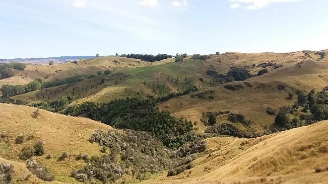
Figure 2.
Figure 2. Example of NZ hill country
country landscapes:
landscapes: high simplification with low regulating services
regulating services
(left); low simplification with high regulating services (right).
(right). Photographed by Duy X. Tran
Tran in
in 2019.
2019.
It is suggested that the issues that originate from landscape landscape simplification due to agricultural
intensification
intensification could
couldonly
onlybebesolved
solvedbyby
taking intointo
taking account the redesign
account of agricultural
the redesign landscapes
of agricultural [180].
landscapes
The goal
[180]. The of goal
the approach suggested
of the approach in this paper
suggested is topaper
in this redesign (orredesign
is to plan) the(or
agricultural
plan) the landscape to
agricultural
achieve
landscape a better balance
to achieve between
a better ecological,
balance cultural
between and production
ecological, cultural functions [180]. The
and production cultural
functions and
[180].
production
The culturalfunctions reflect the
and production capability
functions of thethe
reflect landscape to produce
capability goods and
of the landscape toservices
producethat support
goods and
human
servicesdemand fromhuman
that support a socio-economic
demand from perspective [181]. Whereas
a socio-economic maintaining
perspective and improving
[181]. Whereas maintainingthe
ecological
and improvingfunctions of the landscape
the ecological is thought
functions of the to increase is
landscape biodiversity
thought toand landscape
increase connectivity,
biodiversity and
which has important
landscape conservation
connectivity, which has and landscapeconservation
important resilience implications, including
and landscape the ability
resilience to adapt
implications,
to climate change and disturbance [182–185]. The creation of this kind of landscape is expected to be
an effective solution to solve the problems related to landscape simplification in NZ hill country farms.Land 2020, 9, 185 12 of 29
The justification for this is that a multifunctional agricultural landscape that is made up of a mosaic of
natural habitat areas and agricultural production areas could help to maximize the balance of ecological
and socio-economic demands and minimize the conflicts between them [186]. This allows the landscape
to provide multiple services and achieve multiple objectives (both agricultural production demand
and environmental standards) [51,187]. By diversifying farming activities, farmers can secure various
income sources whilst at the same time promoting the cultural and natural heritage [188]. For instance,
a sustainable multifunctional agricultural landscape may provide the option to develop agritourism or
environmental education. Consequently, this contributes to an added income for farmers and increases
public interest in the social and environmental values that the farms bring to the community. However,
the challenge comes in determining how to implement the multifunctional landscape approach as
a practical application to develop a sustainable agricultural landscape where different land use and
land cover types (e.g., wetland pasture, forest, and horticulture) co-exist and the land use pattern is
appropriate to maintain and promote sufficient heterogeneity so that different landscape functions
work properly [189,190].
4. A Conceptual Framework that Combines Multifunctional Landscapes and Geodesign Concepts
for Sustainable Agricultural Landscape Planning
In this paper, we propose a conceptual framework for sustainable agricultural landscape
planning (Figure 3) that integrates the concept of multifunctional landscapes with a geodesign
approach. It also draws on several studies that have focused on developing a framework for landscape
planning [87,187,191]. The geodesign processes in this framework follows the approach outlined by
Steinitz [31], which comprises six phases. These phases are: (1) Landscape description, (2) Landscape
process; (3) Landscape evaluation; (4) Future landscape scenarios development; (5) Impact assessment
of alternative landscape scenarios; and (6) Decision-making. Within this framework, the basic concepts
of a multifunctional landscape and a landscape services approach can be fully integrated.
4.1. Landscape Description
The landscape description phase is used to describe a general picture of the study area. The first
task is to define an appropriate boundary for the study area. It is suggested to consider both the social
and ecological boundaries (i.e., boundaries that cover both the ecological and socio-political/cultural
functions of the landscape) when defining the boundary for the study area [192,193]. The ecological
boundary of the study area may be determined based on ecological processes or biophysical constraints
(e.g., land management unit, catchment or sub-catchment boundaries) [194]. The cultural functions
of the landscape sometimes may not align with the boundary of the ecological functions, so it is
recommended to work with the “people of the place” to properly define an appropriate boundary [192].
In NZ, a catchment group is a community network of farmers who operate in a particular catchment.
They are increasingly committed to tackling environmental issues and responding to a long-term
sustainable development plan for the catchment [195,196]. Working with such groups offers the
potential to assist in developing a relevant cultural boundary.
Once the study area boundary is defined, the next step is collecting necessary physical and
socio-economic data, especially data for characterizing landscape services and environmental issues
(e.g., soils, topography, LULC, climate). In the case of NZ hill country, the lack of data is a limiting
factor for analysis. To navigate around this requires an integration of multiple data sources that may
come from the government, research institutions, remote sensing and field surveys. In fine-scale
applications, such as those undertaken at the farm and paddock scales, information provided by
farmers (e.g., stocking unit, grazing rotation) is an important source of data. The integration of local
and global data to model landscape services is therefore a valuable option to address data deficiencies
in remote and data-poor areas [197]. In addition, data are normally archived in different formats,
standards and scales, so data standardization is an important step to make sure multiple data layers
can be appropriately integrated and used.Land 2020, 9, 185 13 of 29
Land 2020, 9, x; doi: FOR PEER REVIEW 13 of 29
Figure
Figure 3.3.AAconceptual
conceptual framework
framework for
fora amultifunctional
multifunctionallandscape-based geodesign
landscape-based for sustainable
geodesign for sustainable
landscape planning, adapted from Steinitz [
landscape planning, adapted from Steinitz [31].31 ] .
4.1.ALandscape Description
representation model (e.g., a raster-based 2D data model) is used to organize and visualize data
collected
The for the study
landscape area through
description space
phase and
is used to over time.
describe For example,
a general picture maps visualize
of the study area.LULC types of a
The first
task is to define an appropriate boundary for the study area. It is suggested to consider both
farm or rainfall and temperature patterns in a catchment from 20–30 years ago to the present. This gives the social
and ecological
a general boundaries
understanding of(i.e.,
the boundaries that cover
landscape (from the both
past the ecological
to the andand
present) socio-political/cultural
provides necessary input
functions of the landscape) when defining the boundary for the study area
for the other stages of the framework. Data resolution and availability will affect all [192,193]. Theother
ecological
processes of
boundary of the study area may be determined based on ecological processes or biophysical
landscape design, as the difference in the resolution and level of data accuracy in the input process
could lead to completely different results. For instance, small landscape features (e.g., small plots of
shrubs or ponds) play an important role in a farm, such as providing biodiversity, water resources andYou can also read