Northport VISION FOR GROWTH WESTERN RECLAMATION - Assessment Of Landscape, Natural Character & Amenity Effects
←
→
Page content transcription
If your browser does not render page correctly, please read the page content below
Northport
VISION FOR GROWTH
WESTERN RECLAMATION

Assessment Of Landscape, Natural Character & Amenity Effects

March 2021
CLIENT:            Northport

PROJECT:           Vision for Growth Expansion of Northport:
                   Western Reclamation

DOCUMENT STATUS:   Draft 4

DATE:              April 2021

AUTHOR:            Stephen Brown

Brown NZ Limited
156 Parnell Rad
Parnell
Auckland 1052

Ph: 09 377 7771

Mob: 021 646 181

           2                              Brown NZ Ltd April 2021
ATTACHMENTS 1-27:

ATTACHMENT 1:        “Western Reclamation: General Cargo” – Concept Plan

ATTACHMENT 2:        “Western Reclamation: Shipyard” – Concept Plan

ATTACHMENT 3:        Northport “Vision for Growth” – Location Aerial

ATTACHMENTS 4 & 5:   Mitigation Concept – General Cargo & Shipyard Scenarios

ATTACHMENT 6:        Whangarei District Plan – Outstanding Landscape Areas & Notable Landscape Areas

ATTACHMENT 7:        Proposed Northland RPS – Outstanding Natural features / Landscapes & Areas of
                     High / Outstanding Natural Character

ATTACHMENT 8:        Indicative Zone of Theoretical Visibility for land areas around Whangarei Harbour

ATTACHMENT 9:        Viewpoint Location Map

ATTACHMENTS 10-24:   Photos from locations near Northport & around Whangarei Harbour exposed to the
                     Western Reclamation & “Vision for Growth” sites:
                     ▪   The intersection of Port Marsden Highway & Ralph Trimmer Drive
                     ▪   Port Marsden Highway
                     ▪   Marsden Point Road crossing Blacksmiths Creek
                     ▪   The Marsden Bay foreshore near Albany Road
                     ▪   Beach access and lookout next to One Tree Point Road
                     ▪   Coastal reserve next to Whangarei Heads Road south-east of Waikaraka Beach
                     ▪   Above 178 Manganese Point Road
                     ▪   Next to Whangarei Heads Road & The Pines Golf Course in Parua Bay
                     ▪   Next to Nook Road above Munroe Bay
                     ▪   Whangarei Heads Road at the northern end of McLeod Bay
                     ▪   Next to No.8 The Heights, Reotahi
                     ▪   Beach Road, Reotahi
                     ▪   Whangarei Heads Road next to Taurikura Beach & Reserve
                     ▪   Above 2401 Whangarei Heads Road & Taurikura Bay
                     ▪   Next to 2487 Whangarei Heads Road within McKenzie Bay
                     ▪   Next to 9 Urquharts Bay Road & the Urquharts Bay beachfront
                     ▪   Home Point gun battery

ATTACHMENTS 25-27:   Night-time Photos from:
                     ▪ the Marsden Bay / Albany Road Beachfront;
                     ▪ The Heights, Reotahi;
                     ▪ Beach Road, Reotahi

                                                 3                                   Brown NZ Ltd April 2021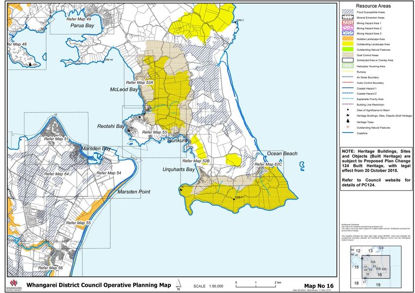
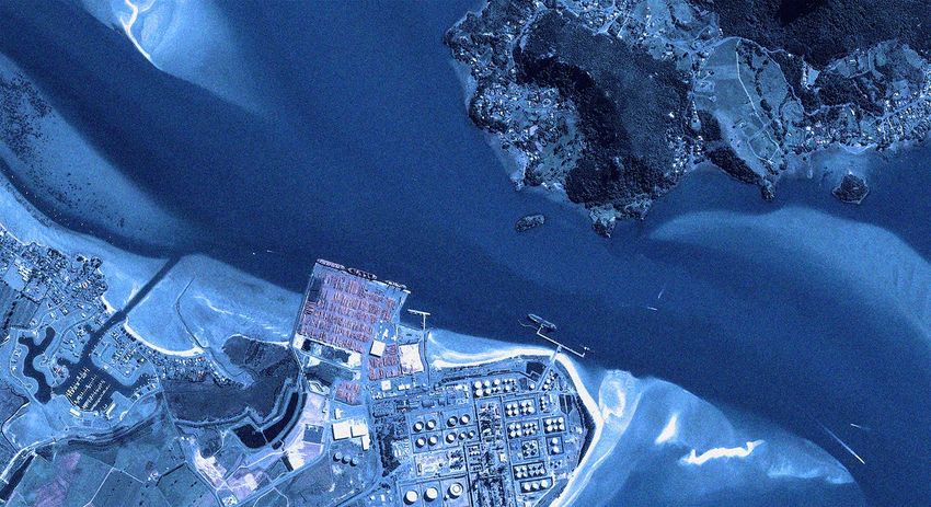
1. INTRODUCTION
This report has been prepared by Brown NZ Ltd for Northport Limited. It addresses the landscape, natural
character and amenity effects that would be generated by berthage expansion at the western end of
Northport’s current port area at Marsden Point – in accordance with Northport’s “Vision for Growth” strategy.
This expansion would result in the port expanding to the outer edge of Blacksmiths Creek and an area of
identified High Natural Character that embraces the Creek and its harbour interface. The proposed expansion
might also incorporate a new dry dock facility and shipyard within the area of proposed expansion – although
this is an optional alternative to use of all of the proposed expansion area for cargo handling.
These effects are analysed and described in the context of the existing deep-water port at Marsden Point,
together with:
• the adjacent Marsden Point Oil Refinery,
• the enclosed waters of outer Whangarei Harbour;
• the often spectacular, coastal landscape of Whangarei Heads opposite Marsden Point; and
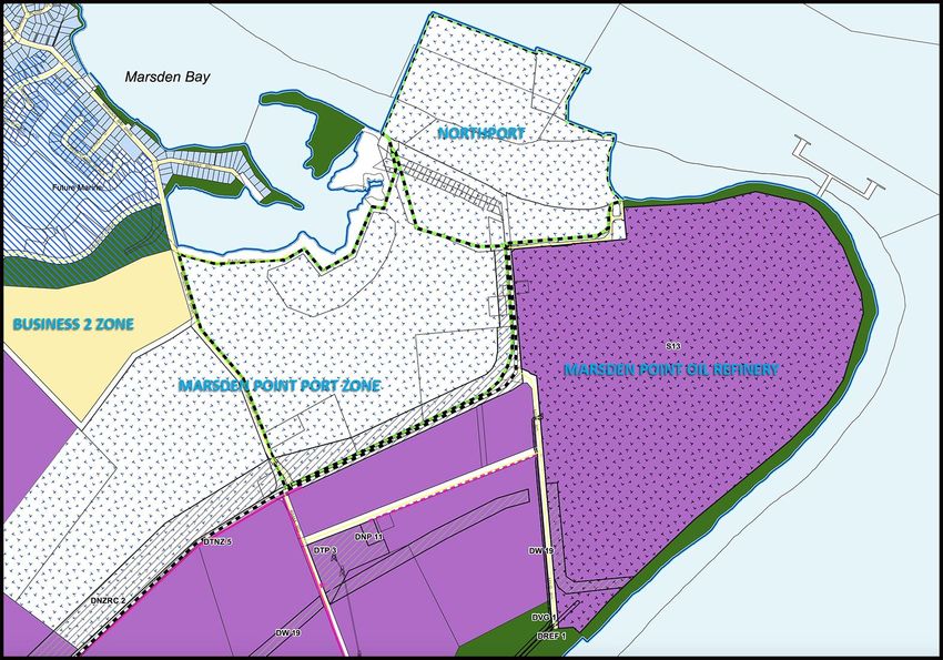
• the “Marsden Point Port” and “Business 2” zoned land that adjoins the current port and refinery.
Although this assessment focuses largely on the proposed ‘western reclamation’ – extending towards
Blacksmiths Creek – Northport is also proposing to develop the eastern end of the current port in the
foreseeable future, subject to a separate application. This expansion would occur directly east of the existing
Berth 3 and the Port’s consented, but yet to be implemented, Berth 4. It would occupy most of Marsden Point
Beach immediately seaward of the Marsden Point Oil Refinery, making provision for a container terminal that
is serviced by new cranes, significantly taller than those currently employed at Northport, together with new
light standards. Both the western and eastern port expansions would also require dredging and construction
operations within the body of Whangarei Harbour close to both the current port and oil refinery.
Because of the likely cumulative impact of these joint Vision for Growth expansion projects on the coastal and
hinterland environs of both Whangarei Harbour and Whangarei Heads, this assessment addresses the
combined / accumulative effects of both applications, irrespective of their exact timing. Consequently, even
though the proposed Eastern Reclamation Project is the subject of a separate report addressing its various
‘landscape’ effects, the content of that report largely mirrors that found in this Western Reclamation report.
4 Brown NZ Ltd April 2021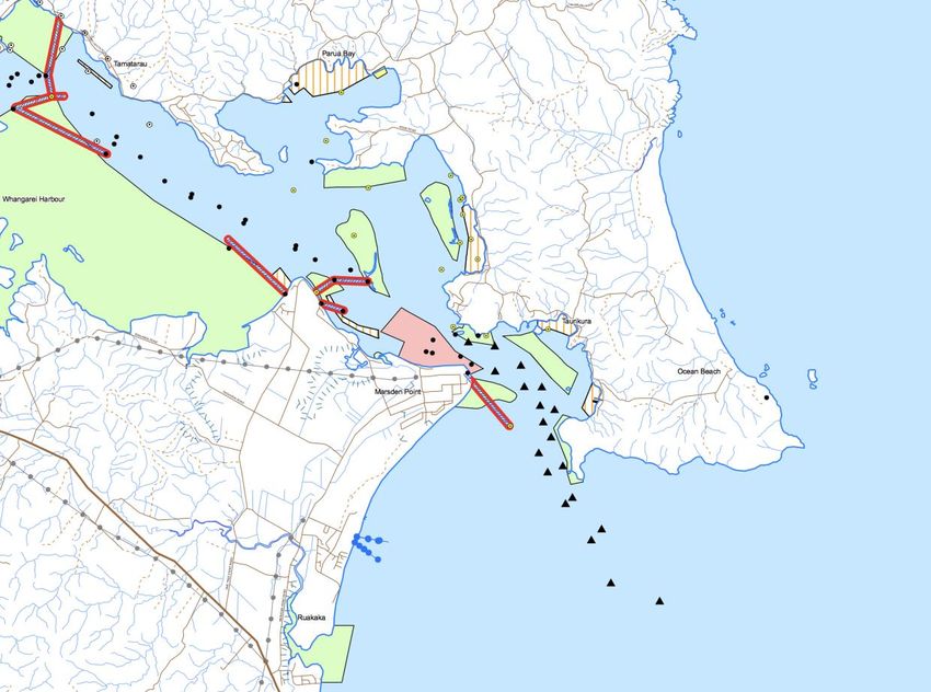
2. PROJECT DESCRIPTION

The current Northport facilities are located at the end of Port Marsden Drive, with approximately 30 hectares
of paved operational area currently serving three berths with a total (harbour frontage) length of 570m. In
addition, Berth 4 is consented, but unimplemented, at the eastern end of the current port. This unimplemented
consent area covers some 4.4ha and, if developed, would extend the current port’s sea frontage by some 270m,
carrying it east of the current pilot vessel jetty and public lookout at the interface of the current port with
Marsden Point Beach. The channel adjoining current Berths 1-3 ranges in depth from 13m to 14.5m.

Another 28 hectares of land is available for port activities behind this paved ‘frontage’, while 180 hectares of
land – stretching southwards from the current port – is available for port related ventures and operations.
Much of the land behind the existing port, extending southwards to, and across, Marsden Bay Drive, is available
for heavy industrial activities, while the Business 2 zone south of that road corridor, overlooking the inland
margins of Blacksmith Creek and the Marsden Cove residential-canal development, is designed to
accommodate lighter industry and commercial operations – of the kind otherwise generally concentrated
around Whangarei’s CBD fringe.

Marsden Point Zoning Map: Operative Whangarei District Plan

The Western Reclamation footprint would be roughly triangular in form, occupying a total area of
approximately 10.5ha. Its design land height would match that of the existing Northport land, with its berthage
surface area set at a minimum of 5m above chart datum. This surface would be built up, using dredge spoil
(sands and silts) and imported material (sand, rock and gravel). Two scenarios are proposed for the Western
Reclamation: one seeing utilisation of it solely for cargo handling; the second incorporating a shipyard and dry
dock – as outlined overleaf.

                                                       5                                    Brown NZ Ltd April 2021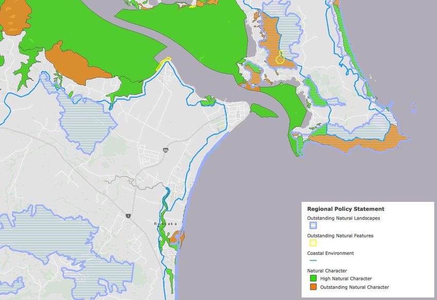
General Cargo Scenario (Figure 1)
              This scenario utilises the entire footprint, with the reclamation’s berthage area merging with that of the existing
              port. Its western edge, facing towards Blacksmiths Creek would be lined by a rip-rap wall that is battered and
              sloping down towards the creek margins – similar to the Port’s current western edge. By contrast, the
              reclamation’s harbour frontage would be lined by vertical sheet-piling. This has yet to be designed, but could
              either comprise an open piled structure or a bulkhead type of wharf.

              Shipyard scenario (Figure 2)
              The shipyard scenario would have a more limited, west-facing batter slope, but would contain a 200m long
              berth at the western end of the reclamation. Again, a battered, rip-rap protected batter slope would run from
              the western shoreline near Blacksmiths Creek out to the sheet-piling of this berth, which would have a vertical
              face and (in all likelihood) a bulkhead type structure. The dry dock berth would be built within the reclamation,
              comprising a 280m by 110m indent (approximately 3ha) that opens put to the harbour (Figure 3). This would
              contain two berths, one for the floating dry dock (SY2) and the other (SY3) for vessels undergoing maintenance
              which do not require dry-docking. These would sit parallel with the previously mentioned, wharf (SY4) at the
              end of the reclamation. Vessels within the dry dock would be serviced by 3 to 4 cranes.

Figure 1: Layout showing western reclamation with the General Cargo         Figure 2: Layout showing reclamation with Shipyard Scenario
          Scenario (the pink area is the berth pocket)                                (the pink areas are the berth pockets)

                                                                      6                                      Brown NZ Ltd April 2021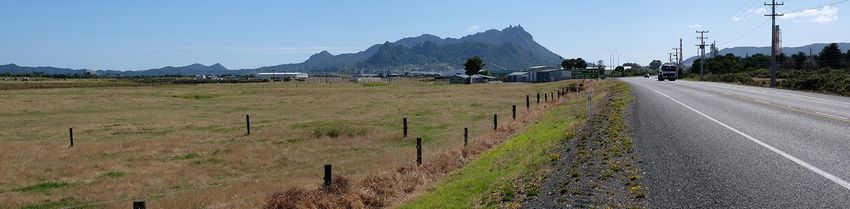
Figure 3: Layout of the proposed dry dock under the Shipyard Scenario

In addition, Northport is proposing the separate, eastern expansion outlined in Section 1 of this report. This
would occupy most of the Marsden Bay Beach area, with Areas 4 and 5 covering a combined area of
approximately 17.1ha. Again, the new berth surfaces would marry with the hard standing of the current port.
Figures 4 and 5 (overleaf) illustrate the configuration of the Eastern Reclamation and its proposed use.

It is important to note, however, that the Eastern Expansion application will only address Area 5, as Area 4
comprises the Berth 4 area that was consented in 2004. It effectively comprises part of the ‘existing
environment’ within which the effects of both the Western and Eastern Expansions must be assessed and
evaluated.

                                                          7                               Brown NZ Ltd April 2021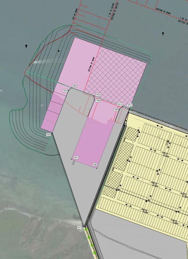
Figure 4: Layout showing the footprint of eastern reclamation and wharf in grey. Note the gap to the east is the already
          consented but not constructed Berth 4 Reclamation (4.3) and wharf (270m).

Figure 5: Artist impression of a container terminal on the eastern reclamation

The Eastern Reclamation would also add the following components to Northport’s current ‘structural
inventory’:

STS Cranes: would load and unload ships, moving containers from the wharf deck to the ship and vice versa.
            The proposed crane is a super post-panamax size, similar to the newer Port of Tauranga (POT)

                                                            8                                        Brown NZ Ltd April 2021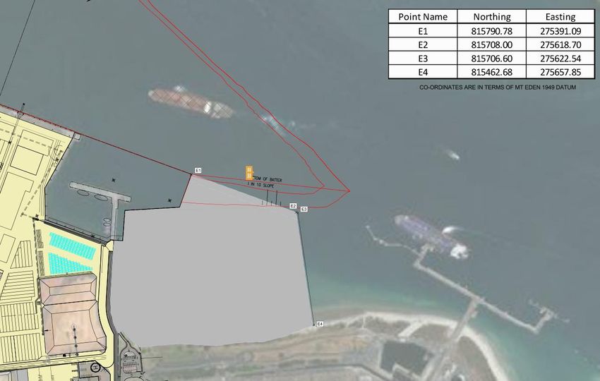
STS cranes (Photograph 1). Up to 8 of these STS cranes could be used, each having the following
             general dimensions:
                •   Height in operational mode (boom down, to top of apex) 81m
                •   Height in storage mode (boom up, to top of boom) 106.5m

             Photograph 1 Super Post Panamax STS at POT

Gantry Cranes &
Container Stacks: that would be employed to store containers on site while they are waiting to be picked up
                  or loaded. Northport anticipates that the expanded container terminal would employ a
                  gantry crane mode of operation, which accommodates denser and higher container
                  stacking, with key dimensions are likely to be:

                    •   Stacked container blocks that are up to 7 high, 8 wide and 180m long, resulting in
                        individual blocks that are up to 21m high and 20m wide;
                    •   Provision for up to 15 such container blocks, each with 1-2 gantry cranes servicing
                        them; and
                    •   The individual gantry cranes – each 30m wide by 25-30m high.
                    •   In a fully developed scenario, there could be.

In addition to these key elements, the following features would also be present:
  ➢ Access and circulation roads;
  ➢ An area of empty container stacking, likely up to nine containers high – approximately 25m high;
  ➢ An area dedicated for refrigerated container stacking – likely up to 4 high;
  ➢ Steel latticework reefer towers to facilitate electrical connection to the refrigerated containers;
  ➢ Container exchange facilities to load and unload trucks;
  ➢ A rail siding and associated unloading and loading facilities;

                                                      9                                    Brown NZ Ltd April 2021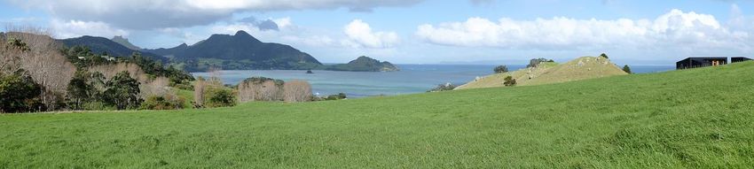
➢ Workshops and maintenance facilities;
  ➢ Lighting, expected to comprise similar setup to currently installed (35m poles, likely with LED lighting
    but could be high-pressure sodium initially).

Cumulatively, the port’s harbour frontage would lengthen from 570m to approximately 1360m and its total
area of wharf ‘hard standing’ would expand by some 26.7 hectares to a combined area of 56.7 hectares. In
addition, the combined ‘Vision for Growth’ projects would require dredging of the following sand volumes to a
depth of -14.5m (below MHWS) – again as shown on Attachment 1:

         Area 1 (directly off the current port):
              Volume:                       4,500m3

         Area 2 (at the eastern end of the current port):
              Volume:                       213,500m3

         Area 1 (at the western end of the current port):
              Volume:                       755,000m3

2.1 LANDSCAPE MITIGATION

The Western Reclamation side of the port faces towards both Marsden Cove and One Tree Point, residential
communities that are lined by both an extensive beachfront directly west of Blacksmiths Creek and an elevated
line of coastal cliffs that extends down One Tree Point to its yacht club. The proposed extension of the western
end of the port would draw the wharf area closer to both this shoreline and local residential areas immediately
behind it. More intermittently, it would expose the wharf edge to those using One Tree Point Road and
Marsden Bay Drive.

In response to this, a mitigation proposal has been developed, as shown on Attachment 4. Under the Western
Reclamation’s General Cargo Scenario, this comprises a strip of twenty 3 x 3m planters at 20m centres
constructed within the proposed western sea wall facing Blacksmiths Creek. Under the Shipyard Scenario, the
same wall would shorten and the number of pohutukawas and planters would be reduced to 17. Regardless,
the pohutukawas would be grown (and irrigated) to form a buffer down that part of the Western Reclamation
margin. Eventually, this would form a near solid screen of vegetation facing towards Blacksmiths Creek and
Marsden Bay. The likely effectiveness of this mitigation is further discussed and analysed in Section 6.3 of this
report, which examines the landscape, natural character and amenity effects of the Western Reclamation
project (together with the wider, Vision for Growth proposals) on key catchments and audiences around
Marsden Point and Whangarei Harbour.
.

                                                        10                                   Brown NZ Ltd April 2021
3. LANDSCAPE CONTEXT
The landscape that frames both the outer reaches of Whangarei Harbour and Marsden Point is one
of multiple contrasting elements and features - notably:
▪ between the flat planes of the water areas found within both the outer harbour and across
Bream Bay dramatically enclosed by the volcanic peaks and native forests of Whangarei
Heads;
▪ Between the enclosed, ‘captured’ waters of Whangarei Harbour and the open expanse of
Bream Bay (merging with the even more open seas of the Pacific Ocean);
▪ Between the serrated, often evocatively jagged, profile of the main volcanic peaks around
Taurikura, Mt Lion and Bream Head that are counterbalanced by the dune terraces and
coastal plain of Ruakaka – culminating in the distal spit of Marsden Point; and
▪ Between a chain of coastal settlements down the northern side of the harbour cossetted by
the peaks and forest already described, that contrast with a much flatter, coastal plain lining
the southern side of the harbour that is populated by the existing oil refinery and Northport
berths, together with the residential development lining both Marsden Bay and One Tree
Point.
This dichotomy is evident both in distant views – such as those first captured form the crest of the
Brynderwyn hills – and at much closer range, while meandering along Whangarei Heads Road or
approaching the current port via the Port Marsden Highway and One Tree Point Road.
Within all of these views, the deep harbour waters channelled out past both Northport and the oil
refinery are framed by the line of volcanic peaks extending from Manaia and Mt Aubrey to Taurikura,
Mt Lion, and Bream Head in a visually compelling fashion. At the foot of these peaks, a sequence of
bays, headlands and small peninsulas flanks the northern side of the harbour entrance, providing
the setting for a sequence of local settlements and residential enclaves: Parua Bay’s ‘residential farm
park’ and golf course then town centre, McLeod Bay, Reotahi, Taurikura and – close to the harbour’s
eastern terminus - Urquharts Bay. Between these larger residential nodes, a secondary layer of rural-
residential development is scattered through much of the bush and coastal slopes around
Manganese Point, Reserve Point and Munroe Bay, then McKenzie Bay, while the bush, pasture and
sharply etched profiles of both Home Point and Busby Head are embraced by the Home Point
Reserve that also includes a WWII gun emplacement. Nearly all of these topographic features and
their associated settlements look out across the harbour and, to varying degrees, embrace views to
the far side of the harbour, flanked by its oil refinery and deep-water port at Marsden Point.
The oil refinery is perhaps the signature feature of Marsden Point, with its it’s complex array of
storage tanks, pipe work, buildings and infrastructure dominating the headland / spit that marks the
interface between Ruakaka Beach and Whangarei Harbour. Two large jetties and gantries are
outliers to the main refinery, projecting out into the main harbour channel, and these are frequently
occupied by tankers unloading at the two ‘dolphins’. Northport’s adjacent deep-water berths are
constantly in motion, with logs being loaded onto freighters, while trucks re-supply the large timber
and timber chip stockpiles behind the main wharves.
Both are dominant features of the southern shoreline, and their manifestly man-made signatures
are reinforced by a line of housing stretching westwards to the end of One Tree Point next to the
Marsden Yacht and Boat Club and adjoining boat ramp. Together with the more recently developed
Marsden Cove residential canal development, this strip of housing marks the interface between the
extensive Ruakaka Flats and Whangarei Harbour, while further inland, a mixture of open pasture,
11 Brown NZ Ltd April 2021pine woodlots and even native forest (on a small sequence of hills near Takahiwai Marae) flanks the
road network that connects with SH1. Down the more open coastline directly south of both the oil
refinery and existing Northport development, the margins of the Ruakaka coastal terrace are marked
by other signs of development and various activities: the remains of the old Marsden B Power Station
site, various industrial premises linked with the nearby township of Ruakaka, the Ruakaka Sewerage
Plant and pockets of residential development both sides of the Ruakaka River. Old pine blocks and
the Ruakaka Race Course also face Bream Bay from the coastal edge north of the main Ruakaka
settlement.
Even so, the key catchments more directly linked to Northport’s current and proposed developments
remain much closer to the main body of Whangarei Harbour:
▪ In the vicinity of the Port Marsden Highway and both business zones that line the southern
approach to both the existing port and oil refinery;
▪ Around Marsden Cove and the coastal edge of One Tree Point – extending through to Albany
Road and the margins of Blacksmiths Creek;
▪ The main body of Whangarei Harbour generally east of Tamaterau and Manganese Point;
and
▪ The coastline of Whangarei Heads.
3.1 THE LANDSCAPE AROUND PORT MARSDEN HIGHWAY
Travelling down the Port Marsden Highway towards both Northport and the Marsden Point Oil
Refinery, the elevated tanks and pipes of the refinery – in particular its red and white striped main
stack – act as a visual magnet and reference point within a landscape that is otherwise largely
dominated by a broad swathe of pasture that is occasionally subdivided by pine shelterbelts. While
the distinctive outline of Mounts Aubrey and Manaia also become increasingly legible on the
approach to both industrial estates, especially so near Marsden Bay Drive, this mostly flat, planar
landscape also starts to reveal the storage sheds, log piles, ships and cranes that identify the current
port. Large storage sheds both sides of Marsden Bay Road combine with an increasing number of
stacks associated with the oil refinery to draw at least some attention away from the Northport
facilities and activity; nevertheless, it remains clearly legible at the harbour edge, and this amalgam
of industrial elements, together with the heavy vehicle traffic on Port Marsden Highway itself, clearly
lends the current landscape a rather utilitarian quality, that is scarcely alleviated by the mixture of
undifferentiated paddocks and gorse flanking the highway (see Photo 1, below).
Photo 1: Looking towards the existing port down the Port Marsden Highway
Although views down the road corridor towards Mounts Aubrey and Manaia remain relatively clear
and a block of macrocarpa, together with some native shrubs, helps to screen most of the refinery
and its associated electricity substation near the intersection with Marsden Bay Drive, impressions
12 Brown NZ Ltd April 2021remain of a landscape that is on the verge of two major industrial complexes – as indeed it is. From
this point through to the port and Whangarei Harbour the landscape becomes increasingly
dominated by the presence of both complexes, in spite of the fact that most of the Port Marsden
Port and the adjoining Business 2 Zone have yet to be significantly developed. Increasingly, the
refinery’s tanks and infrastructure dominate the skyline to the right (east) of the port highway, while
the open ‘paddocks’ left (west) of the highway rapidly give way to rough grass, drainage ditches and
large piles of logs awaiting shipment. The flatness of the landscape both sides of the highway
accentuates its more utilitarian qualities, and these become even more pronounced approaching
the harbour with both the main refinery compound and secure port area becoming clearly visible.
Overall, therefore, this is very much a working landscape: even though Mounts Aubrey and Manaia
are centrepieces of the skyline visible down the highway corridor, the foreground and middle
distance of views in all directions from it is overwhelmingly dominated by the flat coastal terrace
which frames both the existing port and oil refinery. Both complexes leave an indelible mark on the
Marsden Point landscape, while the combination of further industrial and residential development
around Ruakaka simply accentuates this highly modified, development dominated, aesthetic.
3.2 ONE TREE POINT & MARSDEN COVE
Views from around One Tree Point Road, Marsden Cove and Albany Road – including the beachfront
within Marsden Bay – capture the western end of the Northport facility and the oil refinery beyond
the more natural, intervening, coastal margins of Blacksmiths Creek. Yet, from most of these
locations, the main outlook is directly across Whangarei Harbour, towards Mt Aubrey, Mt Manaia,
Taurikura and the wider sequence of sharply serrated, volcanic peaks that are fundamental to the
outer harbour’s signature (see Photo 2, below). Bush, and pockets of pasture extend down from the
sharply etched profile of these old volcanoes to wrap around pockets of residential occupation and
activity. At the very end of this ‘chain’, Mt Lion and Home Point decisively mark the outer limits of
the harbour, while a broad phalanx of bush extending from Home Point to Busby Head, then out
from Smugglers Bay to Bream Head, helps to further reinforce the more natural qualities of this
‘bookend’.
Photo 2: Looking from One Tree Point towards Mt Aubrey, Taurikura, Mt Lion & the Marsden Point Oil Refinery
While this chain of volcanic peaks, and the mantle of bush spread across most of them, provides a
strong and highly appealing degree of visual counterpoint to the broad expanse of harbour waters
that fronts all of the views from both One Tree Point and Marsden Bay, the ‘candy striped’ main
stack within the oil refinery and an associated array of tanks, ships and structures jutting out into
the harbour’s entry channel provide an additional feeling of contrast and juxtaposition. Yet, these
elements are not so dominant or intrusive that they compromise the more natural qualities of the
harbour entrance and its northern coastline: rather, there a feeling of reasonably attractive tension
is created and the harbour, as a whole, retains both its distinctive character and its dramatic natural
values. Indeed, in some regards, this interplay may actually enhance those qualities in a comparative
sense.
13 Brown NZ Ltd April 2021Importantly, both the port and oil refinery remain essentially peripheral to the open expanse of
Marsden Bay in the foreground. Although also dotted by a few moored yachts near the entry channel
to Marsden Cove’s network of canals, most of the bay merges with the main body of Whangarei
Harbour to create an expansive water area that is largely free of modification and ‘clutter’. It’s
simple, open, plane establishes the visual foundation for the interplay between the harbour and the
jagged line of peaks on its far side. Although the edge of this landscape is also lined by housing
development from the local yacht club through to Albany Road, a buffer strip of grass and
pohutukawas down the steep escarpment next to One Tree Point Road and traversing Marsden Bay
Reserve provides mediation which ensures that the coastal landscape revealed from this quarter is
both dramatic and highly appealing.
3.3 WHANGAREI HEADS
Most of the settlements between Reotahi and Urquharts Bay sit within a broad arc (between Darch
Point and Home Point) that faces directly towards the port and oil refinery across the harbour’s entry
channel. As a result, both the Northport facilities and refinery are key focal-points in views towards,
and across, the harbour entrance. Yet, this is not always the case: descending towards McGregors
Bay and Taurikura Bay on Whangarei Heads Road, the volcanic relief of the surrounding hills, and
their interplay with the waters of the northern harbour reaches, is a defining feature of many views.
In particular, the distinctive profile and visual presence of Mt Lion and Home Point – joint sentinels
at the harbour mouth – is a key facet of the Whangarei Heads landscape (see Photo 3, below).
Photo 3: Looking from Whangarei Heads Road near Mt Manaia towards Mt Lion and Home Point
Outside the relatively sheltered waters and Whangarei Harbour, the waters off Smugglers Bay and
Bream Head mark the junction with Bream Bay and the much more open, and exposed, seas of the
Pacific Ocean – with just the distant Hen and Chicken Islands (Taranga island and the Marotere
Islands) providing any degree of protection from its oceanic swells. As a result, the waters facing the
northern edge of Bream Bay are frequently turbulent and wind-tossed, with the enduringly scenic
qualities of this coastal landscape frequently matched by the turmoil of its sea surface.
At the apex of this interaction between two major sea bodies, DoC’s Bream Head Scenic Reserve
marks the outer limit of Whangarei Harbour, encompassing a series of features that wrap around
the harbour entrance and connect with the spine of volcanic peaks that frame the sequence of
northern bays and settlements already described. Although lying close to the string of coastal
settlements described above and looking back towards a mosaic of housing spread across both
Urquharts and Taurikura Bays, the Bream Head Scenic Reserve still conveys the feeling of being
reasonably remote. It is also imbued with a strongly natural, elemental, quality derived from the
interplay of Smugglers Bay, Busby Head and Busby Head with the open waters of the Pacific Ocean.
Although the area closer to the WWII gun emplacement at Home Point faces back to Marsden Point
and the oil refinery, it also reveals the full sequence of volcanic peaks and ridges that provide the
backdrop to Whangarei Harbour and its necklace of northern coastline settlements. Again, such
14 Brown NZ Ltd April 2021views capture the visual counterpoint of natural and cultural elements / features already described,
together with the sheer drama and dynamic qualities of this landscape as a whole.
While Bream Head Scenic Reserve is only part of the wider Whangarei Heads landscape, many of the
qualities associated with it capture the essence of the wider Heads landscape and its strong sense of
appeal. It is a landscape that is far from natural overall, but which remains substantially defined by
its volcanic underpinnings. These continue to provide dramatic contrast with both the harbour
entrance and the coastal flats directly across its water area. More broadly, the interplay of terrain,
bush and coastal waters with both pockets of residential development and the much bolder forms
of the port and oil refinery, simply add to the drama and dynamism of this landscape, which retains
immense appeal regardless of its modification and development.
IDENTIFIED VALUES
The Northland Regional Policy Statement identifies a number of regionally significant, Outstanding
Natural Landscapes (ONLs) near Marsden Point, together with areas of High and Outstanding Natural
Character – see Figure 2 overleaf. These substantially accord with the ONLs and HNC / ONC areas
also identified in the Proposed Regional Plan for Northland that was notified in September 2017. In
addition, Map 16 of the Operative Whangarei District Plan – see Figure 3 overleaf – identifies
additional, district level, ONLs within Bream Bay and around Whangarei Heads.
Of most relevance to the current Northport proposals are the following, high value, landscape and
natural character overlays:
▪ ONLs (District Plan and RPS) covering the coastal hills and ridges that frame the northern
side of Whangarei Harbour, including Taurikura, Mt Lion, Busby Head, and the coastal ridges
extending from Smugglers Bay to Bream Head.
▪ ONLs (District Plan and RPS) covering most Mounts Manaia, Aubrey and Taurikura – directly
opposite the current port.
▪ A strip of Notable Landscape (district plan) and ONL (Regional Policy Statement) running
along Bream Bay’s beachfront and dune corridor, south of the oil terminal boundary.
▪ An area of Outstanding Natural Character covering the eastern seaward slopes and bluffs on
Mt Aubrey either side of Lort Point.
▪ An area of Outstanding Natural Character covering the seaward slopes and bluffs from
Smugglers Bay through to Bream Head.
▪ Areas of High Natural Character within the harbour either side of the current navigation
channel in and out of Marsden Point, including High Natural Character (HNC) areas covering
Calliope Bank and part of Mair bank either side of the proposed navigation channel.
▪ An area of High Natural Character within Blacksmiths Creek.
▪ Areas of High Natural Character flanking Home Point and the series of coastal ridges and
promontories in its vicinity that culminate in Busby Head.
15 Brown NZ Ltd April 2021Figure 2: Operative Northland Regional Policy Statement map showing areas of Outstanding Natural Character
(orange), High Natural Character (green) & ONLs (horizontal green stripes framed by a mauve border)
Figure 3: Operative Whangarei District Plan Map 16 Showing ONLs (yellow) & Notable Landscapes (orange)
16 Brown NZ Ltd April 2021This complex situation and the related proliferation of areas subject to landscape and natural
character overlays, highlights the various dichotomies and anomalies so apparent around the
harbour and its margins. Whereas its outer waters are physically enclosed and overlooked by a
sequence of quite spectacular, volcanic landforms and tracts of native forest that remain key
components of Whangarei Heads’ signature and identity, this is also a landscape that contains large
coastal settlements, residual areas of farmland, pine woodlots, and a scattering of mooring areas.
Across the harbour, both the port and oil refinery are clearly the ‘stand out’ features of the coastal
environment, while an increasingly solid matrix of housing is consolidating around Marsden Bay and
Cove – separated from both current and future port operations by little more than Blacksmiths
Creek. Although that part of Bream Bay immediately south of the Marsden Point Oil Refinery retains
vestiges of natural character (captured by the Notable Landscape Area of Figure 3, above) and areas
of significant recreational appeal down its coastal edge, these are soon succeeded by the housing
and industrial development closer to Ruakaka.
Hardly surprising, therefore, both the regional and district overlays for landscape and natural
character reveal a veritable ‘patchwork quilt’ of areas of high / outstanding and much lower value.
This simply reflects the highly variable nature and extent of both landscape and natural character
values around Whangarei Harbour and the various dichotomies highlighted in the introductory part
of Section 3.1 in this report.
17 Brown NZ Ltd April 20214. STATUTORY FRAMEWORK
The expanded wharf areas and proposed dredging operations would occupy part of the Coastal
Marine Area that is subject to regional provisions under the aegis of sections 6(a), 6(b), &(c) and 7(f)
of the Resource Management Act, together with Policies 13 and 15 of the NZ Coastal Policy Statement
(2010). As a result, the proposal is subject to assessment against relevant objectives and policies in
the Northland Regional Coastal Plan (2004), the Northland Regional Policy Statement (2016), and
the Proposed Regional Plan for Northland (2017).
The Northland Regional Coastal Plan directly addresses structures, reclamation, dredging and other
activities within the CMA. In relation to that operative document, the proposed wharf development
and dredging proposed by Northport Ltd would fall within the following Coastal Plan ‘zones’:
Marine 2 (Conservation) Management Area (or ‘M2MA’); and
Marine 5 (Port Facilities) Management Area (or ‘M5MA’).
Figure 4: Northland Regional Coastal Plan Zones
None of the proposed works would encroach into any area of the CMA that is zoned Marine 1
(Protection) Management Area (or ‘M1MA’). Nevertheless, a range of objectives and policies within
the operative NRCP are directly pertinent to the current proposals and assessment of them as
Discretionary Activities – including the following:
18 Brown NZ Ltd April 20217.3 OBJECTIVE
The preservation of the natural character of Northland's coastal marine area, and the
protection of it from inappropriate subdivision, use and development.
7.4 POLICIES
1. In assessing the actual and potential effects of an activity to recognise that all parts of
Northland's coastal marine area have some degree of natural character which requires
protection from inappropriate subdivision, use and development.
1. As far as reasonably practicable to avoid the adverse environmental effects including
cumulative effects of subdivision, use and development on those qualities which collectively
make up the natural character of the coastal marine area including:
(a) natural water and sediment movement patterns;
(b) landscapes and associated natural features;
(c) indigenous vegetation and the habitats of indigenous fauna;
(d) water quality;
(e) cultural heritage values, including historic places and sites of special significance to
Maori; ………….
and where avoidance is not practicable, to mitigate adverse effects and provide for
remedying those effects to the extent practicable.
2. Within Marine 1 and Marine 2 Management Areas and the rules that apply to each of those,
identify what subdivision, uses and developments may be appropriate taking into
consideration the actual or potential effects on natural character as required by, amongst
others, Policy 1.1.1 of the New Zealand Coastal Policy Statement.
3. Subject to Policies 1 and 2 above, through the use of rules in this Plan, to provide for
appropriate subdivision, use and development in areas where natural character has already
been compromised, including within Marine 3, Marine 4, Marine 5, and Marine 6
Management Areas. ……..
7. To promote, where appropriate, the restoration and rehabilitation of the natural character
of the coastal marine area where it has been significantly degraded.
The NRCP’s Appendix 3 also identifies the following Outstanding Geological Features and Landforms’
that are listed as being of international, national or regional significance in the NZ Geopreservation
Inventory within and around Marsden Point:
Reserve Point nephelenite flow, garnet andesite and sedimentary rock;
McLeod Bay unconformity;
Taurikura natural jetty;
Port Whangarei fossil beds;
One Tree Point dunes; and
Bream Head stratovolcano
However, it appears that none of these features would be affected by the prosed dredging and wharf
extensions.
19 Brown NZ Ltd April 2021Turning to the Northland Regional Policy Statement, which became operative on 9th May 2016,
Policy 4.5.2 addresses the location of particular parts of the coastal environment (including the CMA)
and landscapes that are particularly sensitive to new development – stating as follows:
The Regional Policy Statement Maps of high and outstanding natural character and outstanding natural
features and outstanding natural landscapes identify areas that are sensitive to subdivision, use and
development. The maps of these areas identify where caution is required to ensure activities are
appropriate.
In my opinion those parts of the coastal environment around Marsden Point and Whangarei Heads
appear to accord with the requirement [under sections 6(a) and (b) of the Resource Management
Act] to identify and preserve / protect such areas from inappropriate subdivision, use and
development. In a related vein, the following landscape and natural character provisions are relevant
to the current proposals:
3.14 Natural character, outstanding natural features, outstanding natural landscapes and
historic heritage
Identify and protect from inappropriate subdivision, use and development;
(a) The qualities and characteristics that make up the natural character of the coastal
environment, and the natural character of freshwater bodies and their margins;
(b) The qualities and characteristics that make up the outstanding natural features and
outstanding natural landscapes; …..
4.6.1 Policy – Managing effects on the characteristics and qualities natural character, natural
features and landscapes
(1) In the coastal environment:
a) Avoid adverse effects of subdivision use, and development on the characteristics
and qualities which make up the outstanding values of areas of outstanding natural
character, outstanding natural features and outstanding natural landscapes.
b) Where (a) does not apply, avoid significant adverse effects and avoid, remedy or
mitigate other adverse effects of subdivision, use and development on natural
character, natural features and natural landscapes. Methods which may achieve
this include:
(i) Ensuring the location, intensity, scale and form of subdivision and built
development is appropriate having regard to natural elements, landforms and
processes, including vegetation patterns, ridgelines, headlands, peninsulas, dune
systems, reefs and freshwater bodies and their margins; and
(ii) In areas of high natural character, minimising to the extent practicable indigenous
vegetation clearance and modification (including earthworks / disturbance,
structures, discharges and extraction of water) to natural wetlands, the beds of
lakes, rivers and the coastal marine area and their margins; and
(iii) Encouraging any new subdivision and built development to consolidate within and
around existing settlements or where natural character and landscape has already
been compromised.
(2) Outside the coastal environment avoid significant adverse effects and avoid, remedy or
mitigate other adverse effects (including cumulative adverse effects) of subdivision, use
and development on the characteristics and qualities of outstanding natural features
and outstanding natural landscapes and the natural character of freshwater bodies.
Methods which may achieve this include:
a) In outstanding natural landscapes, requiring that the location and intensity of
subdivision, use and built development is appropriate having regard to, natural
elements, landforms and processes, including vegetation patterns, ridgelines and
freshwater bodies and their margins;
b) In outstanding natural features, requiring that the scale and intensity of
earthworks and built development is appropriate taking into account the scale,
form and vulnerability to modification of the feature;
20 Brown NZ Ltd April 2021c) Minimising, indigenous vegetation clearance and modification (including
earthworks / disturbance and structures) to natural wetlands, the beds of lakes,
rivers and their margins.
(3) When considering whether there are any adverse effects on the characteristics and
qualities 9 of the natural character, natural features and landscape values in terms of
(1)(a), whether there are any significant adverse effects and the scale of any adverse
effects in terms of (1)(b) and (2), and in determining the character, intensity and scale of
the adverse effects:
a) Recognise that a minor or transitory effect may not be an adverse effect;
b) Recognise that many areas contain ongoing use and development that:
(i) Were present when the area was identified as high or outstanding or have
subsequently been lawfully established
(ii) May be dynamic, diverse or seasonal;
c) Recognise that there may be more than minor cumulative adverse effects from
minor or transitory adverse effects; and
d) Have regard to any restoration and enhancement on the characteristics and
qualities of that area of natural character, natural features and/or natural
landscape.
In addition, the Proposed Regional Plan of Northland was notified in September. It identifies both
the current port and its maritime margins as a Coastal Commercial Zone – extending from west of
Blacksmiths Creek through to east of the oil refinery dolphins (see Figure 5, below):
Figure 5: Proposed Regional Plan for Northland: Coastal Commercial Zone shown in blue
21 Brown NZ Ltd April 2021Related objectives and policies for the Coastal Commercial Zone include the following:
D.5.7
Coastal commercial zone
Development in the Coastal Commercial Zone will generally be appropriate provided it is
consistent with:
1. existing development in the Coastal Commercial Zone, and
2. existing development on adjacent land above mean high water springs, and
3. development anticipated on the land above mean high water springs by the relevant
district plan.
In a similar vein, the Operative Whangarei District Plan also sets out to accommodate both the
development of Marsden Point’s port area as a heavy industrial hub and expansion of its port
facilities:
Part C – Policies – Built Form and Development
Heavy Industry Hubs will provide an environment in which heavy industry can function
effectively without compromise to those activities, or to public health and safety. Sustainable
development of heavy industry is important to the economic wellbeing of the district. Heavy
Industry Hubs will give precedence to industrial activities that may be adversely affected by
reverse sensitivity, and are in an inappropriate location for sensitive uses, such as residential
and/or retail activities. The primary Heavy Industry Hub is at Marsden Point, incorporating
nationally significant infrastructure such as the oil refinery and port.
25.3 Objectives 25.3.1
The avoidance, remediation or mitigation of the adverse effects of activities on the
environment at Marsden Point during the development of land for a deep-water port.
25.4 Policies 25.4.1 Port Operations
To recognise and provide for the operation requirements and effects of the Marsden Point
Port.
25.4.2 Adverse Effects
To avoid, remedy or mitigate adverse effects of the operation or development of activities in
the Marsden Point Port Environment.
Although these objectives and policies establish the statutory framework designed to guide future
development of the port’s industrial area, they have little applicability to the present “Vision for
Growth” proposals as they solely relate to development on land behind Northport’s wharves – not
(as with the current proposals) below MHWS.
22 Brown NZ Ltd April 20215. POTENTIAL EFFECTS
In addressing the effects that the proposed dredging and wharf developments would have on
Whangarei Harbour, it is important to take into account the values associated with different parts of
the landscape / environmental setting already described. The following are brief descriptions of
some of the factors that need to be addressed as part of this process.
5.1 LANDSCAPE
As indicated in Sections 3.1 to 3.4, the landscape and natural character setting framing Whangarei’s
outer harbour is highly variable. However, key parts of that setting are identified as ONLs. Section
6(b) of the Resource Management Act identifies “The protection of outstanding natural features and
landscapes from inappropriate subdivision, use, and development” as a matter of national
importance. The so called ‘modified Pigeon Bay’ factors, that emerged in the findings of the
Environment Court in the Pigeon Bay Aquaculture Limited v Canterbury Regional Council case and
subsequent Wakatipu Environmental Society Inc (WESI) v Queenstown Lakes District Council cases,
are now largely accepted as a starting point for the identification of such landscapes:
a) natural science factors: the geological, topographical, ecological and dynamic components of the
landscape;
(b) aesthetic values including memorability and naturalness;
(c) expressiveness (legibility): how obviously the landscape demonstrates the formative processes leading
to it;
(d) transient values: occasional presence of wildlife; or its values at certain times of the day or of the
year;
(e) whether values are shared and recognised;
(f) the landscape’s value to tangata whenua;
(g) its historical associations.
At the very least they provide a comprehensive check list of landscape ‘layers’ that may or should be
addressed in making determinations about the relative values to be attributed particular landscapes,
and the related effects that development proposals – like the Crude Shipping Project – would have
on them. The Operative Northland Regional Policy Statement builds on this by including the following
summary of key characteristics and qualities associated with the ONLs surrounding Marsden Point and
down the Bream Bay coastline:
BREAM HEAD / MANAIA SEQUENCE
Landscape characterisation (including the identification of any specific characteristics)
A highly distinctive and ‘iconic’ landscape sequence that defines the outer harbour and links out
across the CMA toward Great Barrier Island. A gateway scene to entering mid Northland when
passing over the Brynderwyn ridge. An anchoring element in a sequence of “ecological islands”
with similar coastal indigenous forest associations that progress up the eastern coastline to the
Bay of Islands and bridging into the mainland from local offshore islands. Collectively provide
critical part of the Whangarei Heads area’s social identity, providing an enframing/backdrop
landform to each bay neighbourhood and a repeating theme that structures the experience of
travelling through the broader Heads landscape.
Characteristic features are a very steep landform, rocky pinnacles (and headlands in some
instances), high consistency of forest/shrubland cover (but with diversity in its composition) and
close association with nearby harbour and open coast seascapes
Part of the distinction and definition of the component parts of this OLA results from the fact
that each is typically isolated from the next within a fringe of agricultural grassland in more
23 Brown NZ Ltd April 2021gentle foothills, further highlighting the rugged terrain and forest cover of the outstanding
areas.
Whilst the majority of the identified unit encompasses contiguous areas of forest, scrub or
shrubland vegetation, where linking or adjoining landform under pasture is clearly a part of the
dominant elevated landscape element, these areas have also been included. Thus, the majority
of the Bream Head sequence is within the unit, including:
• pastured areas at the western and eastern ends;
• the forested ridge face of the Mt Lion Range, including the narrow areas of pasture
between the forest and ridge crest;
• pastured areas linking Mt Aubrey with the harbour, and;
• areas of pasture on elevated land contained within the wider forest on the eastern
face of the Manaia range.
• The unit is closely related to Hen and Chickens Island group (which is identified as a
discrete OLA) in terms of landform, ecology, and sequence.
EVALUATION
Criteria Rank Comment
Natural Science Factors
Representativeness 5 Heads sequence a signature of the Whangarei district and Northland region.
Relates to view from Brynderwyn.
Commonly found in photographs and other images that seek to convey an
impression of Whangarei and Northland.
Rarity 5 High level of rarity at New Zealand level – very distinctive to this local area in
terms of visual identity, geology and ecology.
Aesthetic Values
Coherence 4 Strongly unified by rugged landform and contiguity of vegetation cover.
Repetition of those key themes, and relationship with adjacent maritime area
serves to bring an overarching coherence to the respective discrete areas,
despite these being physically separated by lower land and pastoral cover.
Diversity & Complexity 5 Detailed and distinctive skyline.
Convoluted site slopes with multitude of minor catchments. Diverse ecology.
Vividness 5 A bold signature and strong part of Northland’s identity. Extremely distinctive
and memorable. Commonly referred to at many levels by those living in the
Heads area.
Naturalness 4 Very high levels of naturalness within unit, but influenced by proximity of
settlements, farming and port complex. Proximity in turn allows for weed
invasion and abutting uses that diminish naturalness.
Indigenous forest cover is largely consistent over the unit, but there are some
localized exceptions where elements of pasture are found in elevated
locations such as the northern end of the Manaia range, where paddocks
have been created near the ridgeline on localized areas that are less severe in
their terrain.
Closely related to marine waterbody. Small and complex drainage patterns on
hill faces, largely ephemeral. Evidence of dramatic drainage and scouring
during intense rainfall indicates ongoing formative processes, even in areas
where landcover is predominantly natural.
Intactness 4 Good level of intactness within unit, although much of the vegetation cover is
relatively young.
Influence of natural cover along ridges on visual identity.
Experiential Values
Expressiveness 5 Volcanic origins clearly conveyed by both landform and eroded skyline detail.
Sensory Qualities 5 Powerful views of unit entering Whangarei District and along harbour and
Heads.
Transient Values 4 Strongly influenced by light conditions. Ridges create extremely distinctive
silhouettes during dawn and dusk. Seasonal influences of rata and
pohutukawa bloom.
24 Brown NZ Ltd April 2021Remoteness / Wildness 3 Proximity of settlements diminished, but strongly experienced to south of
Bream Head and within forest.
Shared & Recognised 5 Landforms definitive in Heads community and physically shape and define
where settlement has occurred.
Values
Spiritual, Cultural & 5 Consultation was initiated during the mapping process, but has not led to any
feedback within the required period. Well recorded and widely known Maori
Historical Associations mythology applying to Manaia particularly. This is summarized on a public
sign at Manaia’s foot. Broad body of historical knowledge relating to early
European and Nova Scotian settlement and use of Heads area.
5.2 NATURAL CHARACTER
Policy 13 of the new NZ Coastal Policy Statement requires that the following matters be evaluated
when exploring the natural character effects of development proposals within the coastal
environment:
(1) To preserve the natural character of the coastal environment and to protect it from
inappropriate subdivision, use, and development:
(a) avoid adverse effects of activities on natural character in areas of the coastal
environment with outstanding natural character; and
(b) avoid significant adverse effects and avoid, remedy or mitigate other adverse
effects of activities on natural character in all other areas of the coastal
environment; including by:
(c) assessing the natural character of the coastal environment of the region or
district, by mapping or otherwise identifying at least areas of high natural
character; and
(d) ensuring that regional policy statements, and plans, identify areas where
preserving natural character requires objectives, policies and rules, and include
those provisions.
(2) Recognise that natural character is not the same as natural features and landscapes or
amenity values and may include matters such as:
(a) natural elements, processes and patterns;
(b) biophysical, ecological, geological and geomorphological aspects;
(c) natural landforms such as headlands, peninsulas, cliffs, dunes, wetlands, reefs,
freshwater springs and surf breaks;
(d) the natural movement of water and sediment;
(e) the natural darkness of the night sky;
(f) places or areas that are wild or scenic;
(g) a range of natural character from pristine to modified; and
(h) experiential attributes, including the sounds and smell of the sea; and their
context or setting.
Again, the NRPS has evaluated areas of High and Outstanding Natural Character around Marsden
Point with reference to such factors. However, the worksheet descriptions of those areas close to
the current port and proposed dredging areas are largely devoid of detail apart from rather generic
descriptions of the different Natural Character areas identified within the Coastal Environment and
a summary of the referenced ecosystems applicable to each area:
NRC Map No: 15
Coastal Area Covered: Whangarei Harbour – Darch Point to Home Point
Open Coast – Home Point to Ocean Beach including Bream
Head
25 Brown NZ Ltd April 2021Dominant Coastal Criteria Used:
Ridgeline/land contour: Yes Presence and extent of dunefields:
Ocean Beach
Presence and extent of coastal lakes, lagoons, tidal estuaries, saltmarshes, or coastal
wetlands: N/A
Other Relevant Factors:
Defined areas of coastal hazard risk: Ocean Beach
Presence and extent of coastal vegetation:
See Q07/069 Manaia Ridge Scenic Reserve and Surrounds
Q07/070 Mount Aubrey Coastal Forest and Shrubland
Q07/073 Taurikura Ridge Bush
Q07/074 Bream Head Scenic Reserve and Surrounds; and
Q07/075 Ocean Beach Recreation Reserve and Surrounds in
Natural Areas of Manaia Ecological District 2010
Presence and extent of habitats of indigenous coastal species including migratory
birds: N/A ………..
NRC Map No: 15
Coastal Area Covered: Bream Bay – north of Marsden power station site to Marsden
Point
South Whangarei Harbour – Marsden Point to Takahiwai
North Whangarei Harbour – Mount Aubrey
Dominant Coastal Criteria Used:
Ridgeline/land contour: Yes
Presence and extent of dunefields:
North end of Bream Bay beach
Presence and extent of coastal lakes, lagoons, tidal estuaries, saltmarshes, or coastal
wetlands:
Blacksmith’s Creek, Takahiwai Creek
Other Relevant Factors:
Defined areas of coastal hazard risk:
Bream Bay Beach, Marsden Cove, One Tree Point
Presence and extent of coastal vegetation:
See Q07/128 Ruakaka Dunelands
Q07/144 Blacksmith’s Creek Estuary
Q07/143 Takahiwai Creek Estuary; and
Q07/167 Takahiwai Saltmarsh and Shrubland
in Natural Areas of Waipu Ecological District 2007
And Q07/058 Whangarei Harbour
in Natural Areas of Whangarei Ecological District 2001 And
Q07/070 Mount Aubrey Coastal Forest and Shrubland
in Natural Areas of Manaia Ecological District 2010
Presence and extent of habitats of indigenous coastal species including migratory
birds:
See Q07/128 Ruakaka Dunelands
Q07/144 Blacksmith’s Creek Estuary
Q07/143 Takahiwai Creek Estuary; and
Q07/167 Takahiwai Saltmarsh and Shrubland
in Natural Areas of Waipu Ecological District 2007
And Q07/058 Whangarei Harbour
in Natural Areas of Whangarei Ecological District 2001
26 Brown NZ Ltd April 2021In fact, these somewhat rudimentary descriptions provide very little appreciation of the
environmental conditions associated with the multiple areas identified as having ONC and HNC
values around Whangarei Harbour. As a result, the RPS’s landscape assessment and its descriptions
of individual ONLs offer more insight into the nature of the environmental setting for the proposed
navigation channel than the worksheets directly addressing Natural Character values.
5.3 AMENITY
Section 7(c) of the Resource Management Act states that those exercising power under the Act shall
have regard to (among other matters) “The maintenance and enhancement of amenity values”. Such
values are defined as being “those natural or physical qualities and characteristics of an area that
contribute to people’s appreciation of its pleasantness, aesthetic coherence, and cultural and
recreational attributes”. Thus, whereas landscape is often associated with the sort of parameters
already described, the concept of “amenity” focuses more directly on a certain cohesion of
expression and unity of elements that give rise to a locality or landscape being considered ‘pleasant’,
‘aesthetically cohesive’ and having cultural or recreational appeal. Thus, for example, rural amenity
has more to do with an area’s continuity of character and aesthetic appeal than with how natural,
endemic or structured and patterned it is. This may be reinforced by legible, repeated patterns – such
as those associated with shelterbelts or stands of trees and repeated landforms – which become part
of a locality’s signature. Moreover, such patterns and elements can reflect the actions and imprint of
humankind on a landscape although, more commonly, it reflects a certain repetition of residual
natural features e.g. stands of bush, stream corridors or karst (limestone) outcrops.
Consequently, just as Whangarei Head’s volcanic terrain, bush and harbour waters comprise the
landscape’s basic building blocks, local amenity values are derived from a wide range of experiences
that contribute to the aesthetic value, identity and sense of place associated with those elements
and local area as a whole – including:
▪ the myriad views to, and from, the harbour and its varied coastal margins;
▪ the recreational resources provided by local beaches and beachfronts;
▪ the spectacle and resource offered by DoC’s Bream Head Reserve covering the northern side
of the harbour mouth from Home Point to Bream Head, with its trails, beaches, bush and
scenic promontories; and
▪ the waters of the harbour and its merger with Bream Bay – catering to fishermen, boaties
and visitors alike.
As already implied, the outlook to Whangarei Harbour and Bream Bay clearly underpins much of the
locality’s residential appeal, and the interaction between land and sea is unquestionably a key part
of the northern coastline’s identity and sense of place. Local residents on both sides of the harbour
are exposed to the highly appealing interplay between the landscape’s sea areas with both an array
of enclosing volcanic peaks and the dune plain around Ruakaka marching southwards towards the
Brynderwyns.
Yet, these experiences don’t exist in a vacuum, as if divorced from the very human activities and
structures that surround most of the vantage points which afford this engagement and interaction.
Just as the sharp faced hills, native forest and harbour waters are key components of the outer
harbour’s coastal landscape, it also contains a multiplicity of long established cultural elements –
from the many local settlements already described to the deep-water port and adjoining oil refinery
– that also contribute to the aesthetic appeal and ‘coherence’ of outer Whangarei Harbour, as well
as its appeal as a recreational resource.
27 Brown NZ Ltd April 2021You can also read