OLD BAR BEACH COASTAL PROTECTION STRUCTURE DESIGN INVESTIGATION - GREATER TAREE CITY COUNCIL 10 December 2013
←
→
Page content transcription
If your browser does not render page correctly, please read the page content below
OLD BAR BEACH COASTAL PROTECTION
                  STRUCTURE DESIGN INVESTIGATION

GREATER TAREE CITY COUNCIL
10 December 2013
8A0271
HASKONING AUSTRALIA
                                                                                      MARITIME & WATERWAYS

                                                                                                  Suite 5, Level 5
                                                                                                100 Walker Street
                                                                                      NORTH SYDNEY NSW 2060
                                                                                              +61 (0) 2 8854 5000
                                                                                      www.royalhaskoningdhv.com

             Document title       Old Bar Beach Coastal Protection Structure Design
                                  Investigation
      Document short title        Old Bar Design Investigation
                       Status     Final
                         Date     10 December 2013
               Project name       Old Bar
            Project number        8A0271
                       Client     Greater Taree City Council
                  Reference       8A0271gpb‐Old Bar Design Investigation‐FINAL

8A0271gpb‐Old Bar Design Investigation‐FINAL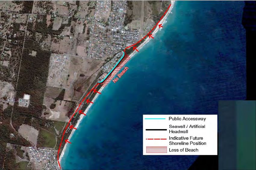
EXECUTIVE SUMMARY
Coastal recession rates at Old Bar Beach are currently some of the highest on the NSW coast. In
2008, three houses at the southern end of the subdivision were threatened by storms and
demolished. Today more private and public property is under threat.
Greater Taree City Council has recently prepared a Draft Coastal Zone Management Plan (CZMP) for
Old Bar (WorleyParsons, 2013). The cost estimates for beach protection run into the tens of millions
of dollars. Planned retreat is recommended as the preferred strategy, a default position based upon
the affordability and availability of any other option contained within the Plan. The Draft CZMP has
not been exhibited or adopted by Council nor has it been endorsed by the State Government. As
such the Draft CZMP has no status. Council recognises that planned retreat is a difficult option for
the community to accept.
Council has retained Haskoning Australia (HKA) to investigate a structural solution which balances
the reasonable concerns of property owners with public beach access and amenity. To be eligible
for funding assistance from the State Government, Council and the community must settle on a
suitably robust and proven long‐term protection strategy.
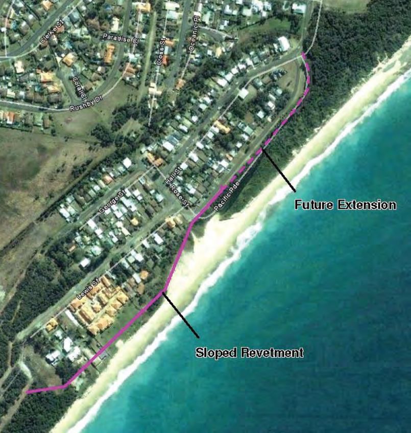
The investigation area at Old Bar Beach extends over 2 km, from the Old Bar Surf Club in the north
to the MidCoast Water exfiltration ponds in the south. Shown in the Figure ES 1 this area includes
the threatened shorefront properties at Lewis Street, Pacific Parade immediately to the north, the
Old Bar Public School and State Environmental Planning Policy 26 Littoral Rainforest.
It was envisaged at the outset that any shore based structural solution would need to be staged with
the critical area for Stage 1 located opposite Lewis Street, north to about Rose Street.
Council identified eight guiding design principles to be achieved with the long term coastal
protection option, namely:
(i) Proven performance and cost‐effective
(ii) Minimise impact on beach amenity and public access
(iii) Resilient and adaptable design
(iv) Public safety
(v) Management of end effects
(vi) Racecourse Creek entrance stability
(vii) Management of shoreline recession impacts
(viii) Feasible structural life
The preliminary design involved a consideration of design life, foreshore protection principles and
staging (triggers), public access and safety principles, ground conditions, construction footprint with
respect to private/public property boundaries, design water levels (including effects of sea level rise),
scour, breaking wave heights, wave runup and overtopping, acceptable damage in storms,
maintenance regime and responsibility, rock sources, construction access, stormwater drainage and
privacy of adjoining landowners.
The range of available options, investigated in the Draft CZMP, is summarised herein. This
comprises ‘do nothing’, planned retreat, revetment, groyne field, offshore reef and beach
nourishment (stand alone and combination). Coastal revetments can be designed with a high
degree of certainty. Similar certainty is presently not available for any of the other structural
8A0271gpb‐Old Bar Design Investigation‐FINAL ‐I‐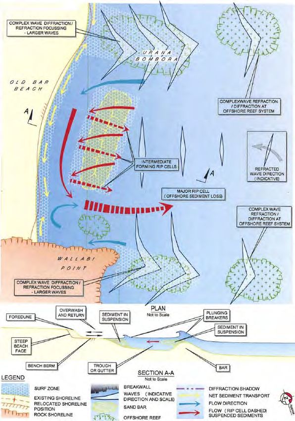
options. As such, a revetment is considered to provide the most reliable and effective means of
coastal protection at Old Bar Beach.

However, revetments can exacerbate localised erosion. There are end effects and possible
outflanking as the adjacent shoreline continues to recede. If the shoreline is not permitted to
retreat, based on observed recession rates the sandy foreshore at Old Bar is expected to be lost
within approximately 10 to 20 years.

The desirable design life for any seawall is 50 years. Although Old Bar Beach is characterised by an
aggressively receding shoreline, a design philosophy has been applied which permits this life to be
achieved.

The preliminary design developed by HKA has the seawall constructed in three stages as designated
in Figure ES 1 and summarised below.

•         Stage 1             Lewis Street properties                  450 m
•         Stage 2             Pacific Parade                           425 m
•         Stage 3N            Old Bar Public School to Surf Club       525 m
•         Stage 3S            MidCoast Water assets                    1,600 m

Based on an updated assessment of the average long term recession rate of 0.8 m/year, and
assuming a sea level rise due to climate change of 0.4 m to 2050 and 0.9 m to 2100 (both relative to
1990 levels), present estimates of trigger dates for commencement of the detailed designs at the
various stages are as follows:

•         Stage 1             2013
•         Stage 2             2013
•         Stage 3N            2021
•         Stage 3S            2037

The trigger dates would be continuously revised on the basis of the actual recession rates.

Two preliminary seawall designs are developed, a conventional rock armoured coastal revetment
and a concrete pile seawall, both as non‐overtopped structures. The rock revetment comprises two
layers of 3.9‐6.6 tonne igneous armour over underlayer and geotextile. The piled wall is not
favoured due to higher wave reflections, complicated construction and price.

The preliminary capital cost estimates developed for the seawall projects based on the preliminary
rock revetment designs are as follows:

•         Stage 1 (Option 1)            $8.0 million ($17,900/m)
•         Stage 1 (Option 2)            $8.3 million ($18,500/m)
•         Stage 2                       $7.0 million ($16,500/m)
•         Stage 3N                      $8.8 million ($16,900/m)
•         Stage 3S                      $24.3 million ($15,200/m)

The preliminary design is developed for two cross‐shore positions for Stage 1: Option 1 with the
crest of the wall aligned with the current dune escarpment, and Option 2 with the wall located as far
landward as possible but allowing for building foundation stability and maintenance access. The

8A0271gpb‐Old Bar Design Investigation‐FINAL              ‐ II ‐
affected landowners prefer Option 1 while the NSW Office of Environment and Heritage prefer
Option 2.

For preliminary costing of maintenance, 0.5% per year is proposed between 2013 and 2038 (mid‐
life), and 2% per year between 2038 and 2063. An additional maintenance provision for sand
placement to manage end effects is required in the order of 500‐1,000 m3 /year per wall end on
average following exposure of that wall end as a consequence of long term recession and storms.
The cost estimates developed in the report make no allowance for any costs associated with
property acquisition.

While Stages 1 and 2 are required in the short term, Stages 3N and 3S are not expected to be
implemented for a number of years. Progressing to the latter stages of the seawall project at Old
Bar has the advantage of being able to monitor the wall and beach behaviour over a reasonable
period of time. If beach recession trends change, then the time for implementation of Stages 3N
and 3S would also change. For these latter stages, it would also be prudent to explore any cost‐
benefits associated with possible relocation of selected public assets rather than their protection.

8A0271gpb‐Old Bar Design Investigation‐FINAL           ‐ III ‐
Figure ES 1 ‐ Preliminary design developed by HKA with seawall constructed in
                                         three stages.

8A0271gpb‐OldBarDesignInvestigation‐FINAL.docx                                          ‐ IV ‐
CONTENTS

                                                                                        Page

EXECUTIVE SUMMARY                                                                          I

1      INTRODUCTION                                                                        1
       1.1   Background                                                                    1
       1.2   Objectives                                                                    2
       1.3   Works Area                                                                    2
       1.4   Scope of Work                                                                 3
       1.5   Nomenclature: Seawalls and Coastal Revetments                                 3
       1.6   Level Datum and Chainage                                                      4
       1.7   Acknowledgements                                                              4

2      INCEPTION DISCUSSIONS WITH GTCC AND OEH                                             5
       2.1    Pre‐Tender Discussions                                                       5
       2.2    Inception Meeting                                                            5

3      SITE INSPECTIONS                                                                   6
       3.1     Inspection at Pre‐Tender Meeting (9/9/13)                                  6
       3.2     Detailed Walkover Inspection (23/9/13)                                     7

4      CONCEPTUAL UNDERSTANDING OF SEDIMENT DYNAMICS                                       8
       4.1  Introduction                                                                   8
       4.2  Old Bar Coastal Erosion Study (Sinclair Knight & Partners, 1981)               8
       4.3  Black Head to Crowdy Head Coastal Hazard Definition Study (WorleyParsons,
            2010a) 9
            4.3.1      Conceptual Processes Model – Ambient Conditions                     9
            4.3.2      Conceptual Processes Model – Storm Conditions                      11
            4.3.3      Influence of Farquhar Inlet and Racecourse Creek                   13
       4.4  Old Bar Beach Stabilisation Investigation Feasibility Study (ASR, 2011)       13
       4.5  HKA Understanding of Sediment Dynamics to inform Preliminary Design of
            Coastal Protection Structure                                                  13

5      APPRAISAL OF STRUCTURAL AND NON‐STRUCTURAL OPTIONS TO ADDRESS
       EROSION AT OLD BAR BEACH                                                           16
       5.1   Introduction                                                                 16
       5.2   Do Nothing                                                                   16
       5.3   Planned Retreat                                                              16
       5.4   Revetment                                                                    17
       5.5   Beach Nourishment                                                            18
       5.6   Revetment and Beach Nourishment                                              20
       5.7   Groyne Field and Beach Nourishment                                           23
       5.8   Offshore Reef and Beach Nourishment                                          25

6      RECENT COASTAL ENGINEERING INVESTIGATIONS AND PROJECTS AT OLD BAR
       BEACH                                                                              28
       6.1   Introduction                                                                 28

8A0271gpb‐Old Bar Design Investigation‐FINAL        ‐I‐
6.2       Multipurpose Reef Proposal                                               28
                 6.2.1      ASR Investigation                                             28
                 6.2.2      WRL Peer Review                                               30
       6.3       Lewis Street DA                                                          31
                 6.3.1      General                                                       31
                 6.3.2      Determination                                                 32
       6.4       AUS Seawalls / Tideline                                                  32
                 6.4.1      Background                                                    32
                 6.4.1      Waterlöffel Model Testing                                     33
                 6.4.2      Waterlöffel Seawall Performance in KwaZulu Natal              35
                 6.4.1      Large Waterlöffel Blocks to Improve Seawall Performance       36

7      GTCC DESIGN PRINCIPLES FOR COASTAL PROTECTION STRATEGY                             38
       7.1   Introduction                                                                 38
       7.2   Proven Performance and Cost Effectiveness                                    38
       7.3   Minimise Impact on Beach Amenity and Public Access                           38
       7.4   Resilient and Adaptable Design                                               39
       7.5   Public Safety Requirements                                                   39
       7.6   Management of End Effects                                                    40
       7.7   Racecourse Creek Entrance Stability                                          41
       7.8   Management of Shoreline Recession Impacts                                    42
       7.9   Feasible Structural Life                                                     42

8      SELECTION OF PREFERRED LONG TERM COASTAL PROTECTION OPTION                         44

9      PRELIMINARY DESIGN OF COASTAL PROTECTION STRUCTURE FOR OLD BAR
       BEACH                                                                              46
       9.1   Basis of Design (BOD)                                                        46
             9.1.1       Design Life                                                      46
             9.1.2       Foreshore Protection Principles and Staging (Triggers)           46
             9.1.3       Public Access and Safety Principles                              48
             9.1.4       Ground Conditions                                                48
             9.1.5       Construction Footprint with respect to Private/Public Property
                         Boundaries                                                       49
             9.1.6       Design Water Levels (including effects of SLR)                   50
             9.1.7       Design Scour Level at the Structure                              51
             9.1.8       Design Breaking Wave Heights at the Structure                    52
             9.1.9       Design Wave Runup Level                                          52
             9.1.10      Acceptable Damage in Design Storm                                53
             9.1.11      Maintenance Regime and Responsibility                            54
             9.1.12      Rock Quarry Sources                                              55
             9.1.13      Construction Access to the Beach                                 55
             9.1.14      Stormwater Drainage Provisions                                   56
             9.1.15      Privacy of Adjoining Landowners                                  56
       9.2   Compilation of Available Survey, Geotechnical Information and Utilities      56
       9.3   Mapping of Coastal Hazards                                                   56
       9.4   CAD Preliminary Design                                                       56
             9.4.1       Rock Revetment                                                   56
             9.4.2       Concrete Piled Wall                                              60
       9.5   Preliminary Project Cost Estimates                                           64

8A0271gpb‐Old Bar Design Investigation‐FINAL         ‐ II ‐
10     WORKS IMPLEMENTATION, MONITORING AND REVIEW                                65

11     COMMUNITY DROP‐IN SESSION AND FEEDBACK                                     66

12     REFERENCES                                                                  67

APPENDICES

APPENDIX A:         MEETING NOTES

APPENDIX B:         SITE INSPECTION NOTES

APPENDIX C:         DESIGN OF GABION WALL AT ENTRANCE TO RACECOURSE CREEK

APPENDIX D:         AVAILABLE BOREHOLE LOGS FOR OLD BAR BEACH

APPENDIX E:        ASSESSMENT OF RECESSION TRENDS, DESIGN WAVE HEIGHTS AND SCOUR
                   LEVELS

APPENDIX F:         DRAWINGS

APPENDIX G:         PRELIMINARY COST ESTIMATES

APPENDIX H:        SURVEY RESPONSES FROM COMMUNITY DROP‐IN SESSION HELD AT CLUB
                   OLD BAR, THURSDAY 21 NOVEMBER 2013

8A0271gpb‐Old Bar Design Investigation‐FINAL     ‐ III ‐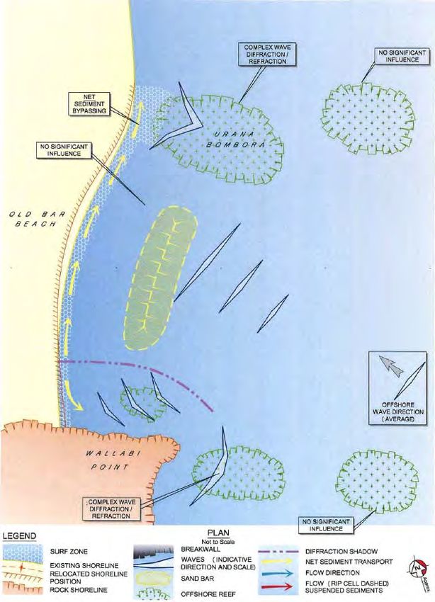
1     INTRODUCTION

1.1   Background

      There is a long history of erosion and threat to coastal properties at Old Bar Beach. Up to 2004 the
      beach was receding at a rate of approximately 0.5 m/year. Since 2004 there has been a substantial
      acceleration in the rate of recession which at present is typically 2 m/year and in some places as high
      as 4 m/year. The recession rates at Old Bar Beach are currently some of the highest on the NSW
      coast. In 2008, three houses at the southern end of the coastal subdivision were threatened by
      storms and demolished. Today, particularly following the updated assessment of coastline hazards
      (WorleyParsons, 2010a), more private and public property is under threat.

      In the mid‐1990’s, the Meridian Resort was being developed. The resort buildings at the time were
      constructed landward of the 100 year erosion line. By 2008, after a re‐evaluation of the coastal
      hazards using updated photogrammetry, the immediate erosion line had reached the main buildings
      on the site. At present these buildings are located within the immediate erosion zone.

      The coastline management process for Greater Taree was commenced in 2008. This progressed to
      the completion of a Coastline Hazard Definition Study (WorleyParsons, 2010a), a Coastline
      Management Study (WorleyParsons, 2010b) and a Draft Coastal Zone Management Plan (CZMP)
      (WorleyParsons, 2013). These investigations described a range of possible options, all of which were
      high cost. There were also issues with public access, and potential structural options, many of which
      were linked to uncertain performance and required concurrent beach nourishment. The feasibility
      of introducing nourishment to Old Bar Beach has been questioned in the Coastline Management
      Study.

      The cost estimates for beach protection at Old Bar run into the tens of millions of dollars. Planned
      retreat is recommended as the preferred strategy, a default position based upon the affordability
      and availability of any other option contained within the plan. Council recognises that planned
      retreat is a difficult option for the community to accept.

      Council is at present seeking a compromise solution, one which balances the reasonable concerns of
      property owners, with public beach access and amenity. Council’s approach is to provide for public
      access to and along the beach to the extent that this can be best achieved. Ultimately it would be
      the community, supported by Council and the NSW Office of Environment and Heritage (OEH), that
      decides how it moves forward at Old Bar. If a coastal protection scheme is to incorporate funding
      assistance from the State Government, then it would be necessary for Council and the community
      to settle on a suitably robust and proven long‐term protection strategy.

      In 2012 a group of landowners along Lewis Street at the southern end of the beach submitted to the
      NSW Coastal Panel a Development Application (DA) for a protection structure comprising sand‐
      filled geotextile containers. This DA was refused. The refusal highlighted the need to develop an
      integrated solution to the erosion problem at Old Bar, and there was also a concern for seawall end
      effects and impacts on beach amenity.

      Prior to the Lewis Street DA, an offshore reef was proposed by some community members as a
      solution to the erosion problem. A feasibility study for an artificial multi‐purpose reef (MPR) to
      protect the beach was finalised in 2011 for the Old Bar Beach Sand Replenishment Group, a group
      formed by concerned local residents with the objective to replenish and preserve sand on the beach.
      The MPR proposal involves two reef structures, each about 110 m long and located 250 m offshore

      8A0271gpb‐Old Bar Design Investigation‐FINAL         ‐1‐
with crest level 0.5 m below mean sea level. The artificial reef proposal is not supported by the State
Government agencies or Council. There is concern regarding the assured performance of the reef,
and a shore‐based protective strategy is now sought. An alternative proprietary crib seawall
solution has also been suggested (AUS Seawalls), however State Government agencies are
concerned that this option would not meet the design objectives.
To progress the management investigations, Council is seeking a preliminary design for a coastal
protection structure at Old Bar Beach. Council and OEH see this as involving a back‐beach
revetment. It is understood by relevant stakeholders that a back‐beach revetment would be
exposed in storms and may lead to a lowering of the beach due to wave reflections. If the long‐term
recession trend continues ultimately the beach would be lost and the sensible approach would be to
provide for longshore access either along or immediately landward of the crest of the structure.
1.2 Objectives
Council requires a technical investigation and report which recommends a preferred coastal
protection structure for Old Bar Beach. The key objectives are to:
• develop a realistic long‐term option;
• provide a preliminary design and cost estimate;
• advise on maintenance requirements; and
• advise on monitoring to gauge impacts of the structure on the beach and foreshore.
The design and implementation of the structure would be staged in accordance with the
development of the erosion threat and to achieve a more manageable costing stream.
There is no requirement for the consultancy to engage the community as part of the investigation.
During the study timetable for this project, Council ran a consultation and communication strategy
simultaneously. This included the presentation of the design to a community drop‐in session held in
Old Bar on Thursday 21 November 2013.
Landscape design input associated with the protective structure is not required. The consultancy is
limited to engineering considerations only.
The NSW Government is currently preparing its Stage 2 reforms to the Coastal Protection Act 1979.
It is the expectation of both Council and OEH that the coastal protection design outcome developed
for Old Bar would be consistent with and potentially inform the development of the Stage 2
reforms.
1.3 Works Area
The investigation area at Old Bar Beach extends over 2 km, from the Old Bar Surf Club in the north
to the MidCoast Water exfiltration ponds in the south. The works area is shown in the attached
Drawings (Appendix F).
The works area covers the threatened shorefront properties at Lewis Street and the road at Pacific
Parade, the entrance to Racecourse Creek, the dunes seaward of the Old Bar Public School, State
Environmental Planning Policy (SEPP) 26 Littoral Rainforest, and the Old Bar Surf Lifesaving Club.
The SEPP 26 areas along the foreshore occur both on the southern side of Lewis Street and behind
the dunes between Racecourse Creek and the Surf Club.
8A0271gpb‐Old Bar Design Investigation‐FINAL ‐2‐It is envisaged at the outset of the investigation that any shore based structural solution would need
to be staged with the critical area for Stage 1 extending south from about Rose Street.
1.4 Scope of Work
Council nominated a 12 week investigation culminating in the delivery of a final report.
Haskoning Australia (HKA) proposed an investigation involving eleven Core tasks and one
Provisional task, as follows:
Core Tasks
• Collation and review of background information
• Site inspection and engineering investigations
• Review conceptual understanding of sediment dynamics
• Summarise structural and non‐structural options to address erosion at Old Bar Beach
• Summarise recent coastal engineering design investigations and projects at Old Bar Beach
• Consider GTCC design principles for coastal protection strategy
• Select a preferred long‐term coastal protection option
• Site meetings and drop‐in session
• Preliminary design of coastal protection structure at Old Bar Beach
• Reporting
• Liaison with GTCC
Provisional Task
• Provisional additional meeting
HKA would remain in close contact with Council, and OEH as required, over the course of the
12 week project. Communications would be by telephone and email. In accordance with the Brief,
HKA would engage Council and OEH in a weekly telephone conference, conducted on Thursdays
commencing 27 September 2013.
A fourth meeting was proposed as a Provisional item.
1.5 Nomenclature: Seawalls and Coastal Revetments
Seawalls and coastal revetments are shore‐parallel structures at the transition between the low‐
lying beach and the higher foreshore or dune. The main difference between a seawall and a coastal
revetment is that a revetment is more sloping than a seawall. A revetment has a distinct slope (e.g.
1v:1.5h), where a seawall is mostly vertical or close to vertical. Revetments usually have a rougher
exterior than seawalls, but can also be smooth.
Seawalls are usually constructed at the foot of the dune or edge of the foreshore. Coastal
revetments may be constructed at the same location or may even be buried further landward (called
terminal revetments).
It is common for coastal revetments to be referred to as seawalls, but not vice versa.
8A0271gpb‐Old Bar Design Investigation‐FINAL ‐3‐1.6 Level Datum and Chainage
All reference to Reduced Level (RL) in this report is given in metres above Australian Height Datum
(AHD). AHD is a local datum which is approximately equal to current Mean Sea Level at the
coastline of mainland Australia.
A chainage system is set up which overlays the OEH photogrammetric block and profile chainage
system for Wallabi Point in the south (S), Old Bar in the central portion of the works area (C), and
Farquhar Inlet in the north (N). Since the OEH profiles are essentially shore‐normal, it follows that
chainages are measured along the crest of the back‐beach escarpment (or future revetment where
this is proposed). The chainage system is shown on the Drawings.
1.7 Acknowledgements
HKA acknowledges the input provided by Laura Black and Richard Pamplin from Greater Taree City
Council (GTCC) in steering the investigation, and Jane Gibbs and Peter Evans from the Office of
Environment and Heritage (OEH) as the officer representatives from the NSW State Government.
Other assistance was provided by Bruce Moore from GTCC and Bob Clout, photogrammetrist from
OEH.
8A0271gpb‐Old Bar Design Investigation‐FINAL ‐4‐2 INCEPTION DISCUSSIONS WITH GTCC AND OEH
2.1 Pre‐Tender Discussions
A mandatory Pre‐tender Meeting was attended by Gary Blumberg from HKA on 9/9/13. This
meeting was also attended by Laura Black, Richard Pamplin and Bruce Moore from GTCC, Peter
Evans from OEH, and the other invited consultant tenderers. Notes prepared by Mr Blumberg from
the Pre‐tender Meeting and selected photos of the site are attached at Appendix A.
2.2 Inception Meeting
The Inception Meeting was held at GTCC chambers in Taree on 23/9/13. This meeting was attended
by Gary Blumberg and Patrick Lawless from HKA, Laura Black, Richard Pamplin and Bruce Moore
from GTCC, and Peter Evans and Andrew McIntyre from OEH. Notes prepared by Mr Blumberg
from the Inception Meeting are also attached in Appendix A.
The provisional program was discussed and confirmed at the Inception Meeting. The additional
data sources listed in the Brief were also requested. Other aspects of the work for which clarification
was sought included shoreline structure design life, options for plant access to the beach and names
of Council’s usual rock quarry sources.
8A0271gpb‐Old Bar Design Investigation‐FINAL ‐5‐3 SITE INSPECTIONS
A site inspection was made during the Pre‐tender Meeting (Section 2.1) and immediately following
the Inception Meeting (Section 2.2).
3.1 Inspection at Pre‐Tender Meeting (9/9/13)
A walkover inspection of Old Bar Beach was made by Gary Blumberg from HKA during the Pre‐
tender Meeting on 9 September 2013. The wind during this inspection was from the NE with 1 to
1.5 m waves breaking within the surf zone. The tide was high and falling.
While OEH indicated that it was not aware of bedrock in the vicinity of the back‐beach, a weak
siltstone outcrop was encountered during the pre‐tender visit (Photo 1). This was observed close to
an indurated mound between Racecourse Creek and the Surf Club, emerging at the base of the dune
(Photo 2). The distribution of these geotechnical features are of interest to the design. A selection
of other relevant photos taken during the Pre‐tender Meeting is provided below.
Photo 1 – Weak siltstone exposed in the back beach Photo 2 – Indurated sand outcrop exposed in the
escarpment approximately 200 m south of the Surf back beach escarpment approximately 200 m south
Club (photo date 9/9/13) of the Surf Club (photo date 9/9/13)
Photo 3 – Norfolk Island pine tree undermined by Photo 4 ‐ Geotextile covered erosion escarpment at
erosion; a number of similar trees have been lost in Meridian Resort with timber steps to the beach
recent years at Old Bar Beach (photo date 9/9/13) (photo date 9/9/13)
8A0271gpb‐Old Bar Design Investigation‐FINAL ‐6‐Photo 5 – Northerly view along Old Bar Beach from severely impacted properties at the southern end of the subdivision. Darker coloured gravel bars are visible in the upper swash zone (photo date 9/9/13) 3.2 Detailed Walkover Inspection (23/9/13) A walkover inspection of Old Bar Beach was made by Gary Blumberg and Patrick Lawless from HKA on 23 September 2013 between 1.45 pm and 4.30 pm. Weather on the day was fine, winds were moderate to fresh from the NE, it was about mid tide with the tide falling to a low at 5.00 pm, and the breaking wave height on the beach was estimated at between 0.5 and 1.0 m. No rain had fallen over the previous two days. The purpose of the walkover inspection was to observe features such as relative coastal exposure, presence of inerodible material in the nearshore and beach, dunal vegetation, proximity to significant stormwater outlets, proximity to built assets, existing protective works, and the eroding escarpment in general. Engineering measurements were also undertaken to confirm distances and approximate relative levels. The inspection commenced at the Surf Club, walking in a southerly direction along the beach to the southern end of the site, and then returning to Rose Street, walking along Pacific Parade along the shore and bank of Racecourse Creek, and finally along the southern boundary of the school into the SEPP 26 hind dines before returning to the beach and completing the circuit. Particular items of interest were located with GPS. Selected photos and notes taken on the day of the inspection are provided in Appendix B. 8A0271gpb‐Old Bar Design Investigation‐FINAL ‐7‐
4 CONCEPTUAL UNDERSTANDING OF SEDIMENT DYNAMICS
4.1 Introduction
A sound understanding of coastal processes and associated sediment dynamics is essential to inform
assessment of the various coastal protection options available for Old Bar Beach. This is particularly
important for the works area where sediment transport processes are highly complex and sediment
loss mechanisms are not fully understood.
Various descriptions of sediment dynamics at Old Bar Beach are available from a number of
different sources. A review of these descriptions is presented in the following sections.
4.2 Old Bar Coastal Erosion Study (Sinclair Knight & Partners, 1981)
The Old Bar Coastal Erosion Study (SKP, 1981) presented a conceptual coastal processes model for
Old Bar, largely based on:
a geomorphological/geological assessment of the area;
analysis of photogrammetric data collected between 1940 and 1979;
analysis of historical aerial photography;
wave and storm surge analysis;
historical assessment of the status of Farquhar Inlet in relation to observed erosion/accretion
trends.
A summary of the key observations outlined in SKP (1981) for Old Bar Beach are as follows:
Variations of the energy distribution along the beach exist because of the nearshore reef
system, which may influence erosion rates.
Adjacent to Old Bar, although a very slight dominance of northerly longshore transport exists,
the potential for longshore transport in both directions is nearly equal.
Further south the net direction of longshore sediment transport along Old Bar Beach is to the
south.
Accordingly, long term erosion is expected to occur at the northern section of the beach
(beyond which northward and southward transport is balanced, but at which the long term
direction is to the south) while accretion is expected at the southern end adjacent to Saltwater
headland (Wallabi Point).
Refraction analysis and wave directions observed in aerial photographs indicate that the
nearshore reef at Old Bar modifies the local inshore wave climate in a way similar to the more
prominent rocky headlands located further south.
The reef system is responsible for a weak sedimentary compartment at Old Bar such that
erosional tendencies at the beach are dictated by local refraction effects.
It is possible that sand taken offshore in rip cells and deposited over the reef might not return to
the beach under favourable conditions due to the barrier effect of the upward projection of
parts of the reef.
The offshore sediment distribution patterns show that any net sand losses to offshore areas
must form as a thin veneer over the existing sediments out to depths of 20‐25 m.
8A0271gpb‐Old Bar Design Investigation‐FINAL ‐8‐4.3 Black Head to Crowdy Head Coastal Hazard Definition Study
(WorleyParsons, 2010a)
The Black Head to Crowdy Head Coastline Hazard Definition Study (WorleyParsons, 2010a) noted that
the regional coastal processes compartment between Black Head and Crowdy Head is highly
complex due to the presence of Farquhar Inlet and Harrington Entrance, as well as a number of
control features including Wallabi Point and Urana Bombora.
WorleyParsons (2010a) presented conceptual process models for Old Bar Beach under both ambient
and storm conditions. Attempts to explain recent increases in beach recession were also presented,
while the potential influence of Farquhar Inlet and Racecourse Creek on sediment dynamics at Old
Bar Beach was also investigated. A summary of the key findings reported by WorleyParsons (2010a)
are presented below.
WRL undertook a peer review of WorleyParsons (2010a), and noted that the coastal processes
presented for Old Bar Beach are speculative but plausible (WRL, 2010).
4.3.1 Conceptual Processes Model – Ambient Conditions
The conceptual processes model proposed by WorleyParsons (2010a) for Old Bar Beach under
ambient conditions is presented in Figure 1, which can be summarised as follows:
Net northward sediment transport occurs along the beach, while refraction and diffraction
effects cause lateral expansion flow to the south and localised accretion at the southern end.
Sediment bypassing of Urana Bombora occurs to the north along the inshore zone, representing
a net loss of sand from the beach compartment. This is largely due to the bombora generally
not being emergent above RL ‐2.5, which limits the effectiveness of this feature to form a
barrier to sediment transport.
Nearshore conditions are characterised by significant longshore currents and high suspended
sediment loads. This may be related to the relatively deep nearshore area (trough) and steep
beach face, whereby waves approach the shoreline relatively unrefracted and break in a narrow
high energy surf zone at a relatively large angle to the shoreline promoting high longshore
currents with a high sediment load.
8A0271gpb‐Old Bar Design Investigation‐FINAL ‐9‐Figure 1 – Old Bar Beach Conceptual Processes Model – Ambient Conditions
(Source: WorleyParsons, 2010a)
8A0271gpb‐Old Bar Design Investigation‐FINAL ‐ 10 ‐4.3.2 Conceptual Processes Model – Storm Conditions
The conceptual processes model proposed by WorleyParsons (2010a) for Old Bar Beach under storm
conditions is presented in Figure 2, and can be summarised as follows:
Waves generally approach the inshore zone from the east due to wave refraction associated
with the extensive nearshore reef systems, which may lead to southerly sediment transport
along the SW‐NE oriented Old Bar Beach.
A differential in water levels would occur as a result of wave setup on Urana Bombora due to
wave focusing on the reef and the width of the surf zone in this area. This would result in a
‘flow’ of water south from the bombora, creating the potential for southward sediment
transport in this area.
Significant potential for sediment entrainment in the surf zone occurs as a result of the typical
beach state (longshore bar and trough), while the steep beach face and relatively low, narrow
berm would be readily eroded during periods of elevated water levels.
Wave diffraction caused by Urana Bombora drives sediment transport to the north and south
(of the reef). The resulting salient removes sand from the southern end of the beach while
limiting sediment supply from the north. Sand from the salient can be mobilised to the north
under ambient conditions resulting in a loss of sediment from the system.
For storm waves from the ESE sector, a large rip cell forms at the southern end of the beach
carrying sediment offshore which may then be effectively lost from the system.
For storm waves from the SE sector, significant volumes of sediment may be transported
offshore to the north in a major rip cell which forms immediately south of the entrance to
Racecourse Creek. This sediment may be deposited against the southern side of Urana
Bombora or recirculated to the nearshore zone by flow across the bombora, resulting in
sediment transport north and south of the bombora at the shoreline. Under these conditions,
there is a net loss of sediment from Old Bar Beach (both offshore and through transport to the
north of Urana Bombora).
For South and SSE storm events the loss mechanism is similar to ambient conditions, with
northward flowing longshore currents inshore of Urana Bombora.
Due to the submarine embayed form of Old Bar Beach and resultant large rip cell formation
during SE and ESE storm events, offshore transport is the dominant loss mechanism.
For storm events with wave directions other than SE and ESE, Urana Bombora is less effective in
influencing the refraction of wave energy, and longshore transport is the dominant mechanism.
Under these storm conditions, inshore bypassing of the bombora occurs, while overtopping due
to suspended sediment load in flows is another bypassing mechanism.
8A0271gpb‐Old Bar Design Investigation‐FINAL ‐ 11 ‐Figure 2 – Old Bar Beach Conceptual Processes Model – Storm Conditions (Source: WorleyParsons, 2010a) 8A0271gpb‐Old Bar Design Investigation‐FINAL ‐ 12 ‐
4.3.3        Influence of Farquhar Inlet and Racecourse Creek

WorleyParsons (2010a) analysed specific periods of photogrammetric data in an attempt to identify
any relationship between the observed erosion at Old Bar Beach and the entrance status of Farquhar
Inlet. The influence of stabilisation works at the entrance to Racecourse Creek was also
investigated, however this was not found to have any significant influence on sand volumes along
Old Bar Beach. In particular, it was noted that the observed dune stabilisation in the immediate
vicinity of the creek entrance could be attributed to stabilisation of the creek alignment (relating to
catchment flows) and not because the constructed gabion wall acting as a groyne to stabilise
longshore sediment transport.

WorleyParsons (2010a) postulated that Farquhar Inlet acts as a significant sediment sink during and
following closure, resulting in erosion of Old Bar Beach. This is due to a reduction in nearshore sand
shoals (ebb tide delta) and infilling of the inlet through aeolian processes, which reduces sand
volumes in the nearshore zone offshore from the entrance. This process changes the nearshore
bathymetry that otherwise combines with Urana Bombora to stabilise (relatively) Old Bar Beach by
supplying sand during southerly bypassing, and reducing the rate of northerly bypassing of Urana
Bombora.

The influence of Farquhar Inlet on erosion at Old Bar Beach was also discussed in Gordon (2013). In
general, it was surmised that the inlet takes sand in from the south (Old Bar Beach) and then
discharges sand offshore during flood events where some moves off to the north while the rest goes
back to re‐form the entrance shoals and berm. The implication of this for Old Bar Beach is that it
tends to experience intermittent phases of recession which occur after, but are linked to, major
floods.

4.4          Old Bar Beach Stabilisation Investigation Feasibility Study (ASR, 2011)

The Old Bar Beach Stabilisation Investigation Feasibility Study (ASR, 2011) suggested that the
ongoing erosion at Old Bar Beach was being caused by cross‐shore sediment transport during
storms. In addition, the observed beach erosion was attributed to erosion of the “old bar” itself, i.e.
the submerged river delta offshore. Offshore reefs comprised of river stones cemented together
with mud stone are elevated above the sandy seabed, and it has been reported that pieces of this
reef have washed up on the beach since the area was first settled in the 1940’s. Reduced elevation
of the offshore “old bar” would increase the potential for wave energy transmission to the shoreline
and lead to beach recession.

WRL undertook a peer review of ASR (2011), and noted that the postulated mechanism for erosion
at Old Bar Beach (i.e., erosion of the “old bar”) were plausible (WRL, 2012). WRL also noted that
that this mechanism could be exacerbated by sea level rise of 1 to 3 mm/year which has been
occurring over the past 50 years (You et al., 2009), leading to greater wave transmission or reduced
wave transformation over the nearshore reef. However, WRL (2011) suggested that other potential
mechanisms for erosion at Old Bar Beach, such as those presented in WorleyParsons (2010a), should
also be considered.

4.5          HKA Understanding of Sediment Dynamics to inform Preliminary Design of
             Coastal Protection Structure

A sound understanding of coastal processes and associated sediment dynamics is essential to inform
assessment of the various coastal protection options available for Old Bar Beach. Based on the

8A0271gpb‐Old Bar Design Investigation‐FINAL         ‐ 13 ‐
information provided above, it is clear that the sediment transport processes at Old Bar Beach are highly complex, with a range of processes dominating under different prevailing conditions. Despite the number and extent of investigations undertaken to date, it is likely that these processes are not fully understood, while the implications of sea level rise on sediment dynamics at Old Bar Beach are also uncertain. There appear to be a number of mechanisms which can potentially transport significant volumes of sand outside the beach compartment, leading to ongoing shoreline recession. These mechanisms are discussed further below. Conversely, sand supply to Old Bar Beach does not occur at significant rates due to sand drift from the south, and instead appears to primarily rely on southward transport during storm events, although it is noted that northward transport may also occur during storms from the S and SSE sectors. In addition, major storms events may be associated with the development of significant rip cells that transport sand outside the beach compartment, and therefore should not be viewed as a mechanism for sand supply. Indeed, cross‐shore sediment transport during storm events is considered to be a major sand loss mechanism for the Old Bar Beach compartment, particularly under prevailing SE and ESE wave directions which are most likely to result in the formation of large scale rip cells. Such conditions can transport significant quantities of sand to water depths beyond the littoral zone where it is effectively lost from the system, leading to further shoreline recession. The influence of Farquhar Inlet also appears to be important, with evidence to suggest that Old Bar Beach erodes in response to a closing of the entrance, and that the erosive process may continue for an extended period due to the time lag in the morphological response. While the opening of Farquhar Inlet during flood events can discharge significant quantities of sand into the nearshore and offshore zones1, much of this material appears to move off to the north while the rest goes back to re‐form the entrance shoals and berm. In addition, sand that enters Farquhar Inlet following entrance opening is likely to predominantly come from the beaches and dunes to the south, most notably Old Bar Beach (Gordon, 2013). Given that the entire region consists of complex reefs with only a thin veneer of sand making up the beach and nearshore zone (Coffey and Partners, 1981), and also considering the lack of significant sand drift from the south, the main source of material supplying the net northward longshore transport is likely to come from the sub‐aerial beach system at Old Bar (Gordon, 2013). While the nearshore bathymetry indicates that Old Bar Beach is essentially embayed between Wallabi Point and Urana Bombora, it is noted that the effectiveness of the bombora to form a barrier to sediment transport is limited by the relatively low elevation of this feature (i.e., below RL ‐2.5). This enables sediment bypassing to occur to the north along the inshore zone and also as overtopping due to suspended sediment load in flows. This bypassing represents a net loss of sand from the beach compartment and may become more significant in response to predicted sea level rise. Overall, it is considered that significant sand losses can occur at Old Bar Beach in response to either longshore or cross‐shore processes. Spatially, these processes occur over regional scales in response to the complex bathymetry in the area and the significant influence of entrance dynamics associated with Farquhar Inlet. Temporally, sediment dynamics at Old Bar Beach could vary over 1 It is estimated that approximately 2 million m3 of material was jetted offshore onto the shallow reefs as a result of the June 2011 flood, estimated to be a 1 in 20 year (5% ARI) event (Gordon, 2013). 8A0271gpb‐Old Bar Design Investigation‐FINAL ‐ 14 ‐
time scales ranging from individual storm events to seasonal and decadal fluctuations, the latter
evident in the marked recessional trend plainly observed over the past 13 or so years. Effective
coastal protection options would need to consider the range of scales over which these processes
operate. It is fair to conclude that no single structural solution would adequately address all of the
sediment loss mechanisms occurring at Old Bar Beach.

8A0271gpb‐Old Bar Design Investigation‐FINAL         ‐ 15 ‐
5 APPRAISAL OF STRUCTURAL AND NON‐STRUCTURAL OPTIONS TO ADDRESS
EROSION AT OLD BAR BEACH
5.1 Introduction
A range of structural and non‐structural options available for Old Bar Beach are reported in the
Coastline Management Study (WorleyParsons, 2010b). These include:
Do nothing ‐ emergency response
Planned retreat
Revetment
Beach nourishment
Revetment and beach nourishment
Groyne field and beach nourishment
Offshore reef and beach nourishment
Each of these options are described in the following sections, including discussion of their potential
application for Old Bar Beach. The descriptions presented below are largely produced from previous
studies, particularly the Coastline Management Study (WorleyParsons, 2010b).
5.2 Do Nothing
It is understood that to “do nothing” and resort only to emergency response is not acceptable to
Council, OEH or the local community. As such, this option has not been considered further herein.
5.3 Planned Retreat
Planned retreat is a strategy that can be used to allow development to exist on a receding coastline
for a period of time until the risk to property becomes unacceptable. The trigger for implementing
planned retreat can be either time‐based (e.g. occupation of an area is allowed until a certain date)
or based on physical realisation of coastal hazards (e.g. when an erosion escarpment encroaches
within a specified buffer distance from a dwelling). If implemented on an undeveloped coastline,
planned retreat can be facilitated by construction of relocatable buildings, which can be readily
moved when development consent lapses and landowners are required to cease occupation and
retreat further landward.
In the case of a well‐developed coastline such as Old Bar, this approach becomes problematic to
implement as private landowners would be required to demolish their existing dwellings and
completely rebuild at significant cost. There are a number of issues associated with the
implementation of planned retreat at Old Bar, including:
retreat of dwellings is limited by the position of important infrastructure such as roadways,
sewer and water mains, and other private properties;
a planned retreat policy would place a time horizon on the development of portions of lots and
would devalue existing property;
it encourages landowners to implement illegal protective works to maintain the position of their
dwellings which may impact on beach amenity and increase risks to adjacent properties.
As outlined in WorleyParsons (2010b), the implementation of planned retreat at Old Bar Beach over
a 50 year planning period would likely involve the following:
8A0271gpb‐Old Bar Design Investigation‐FINAL ‐ 16 ‐ rezoning land at immediate risk form coastal erosion;
specific development controls for future developments, such as the requirement for light weight
timber construction on piers landward of the 50 year hazard line;
possible partial acquisition of land on the seaward side of Lewis Street to maintain legal public
access to the beach in the short‐term, and longer term acquisition of properties for continued
beach access where the entire lot, or close to the entire lot, is seaward of the 50 year hazard
line;
possible acquisition of land between the property boundary and 5 m setback line for properties
along Pacific Parade to maintain road access;
possible funding to a total of $9.9 million for acquisition of the properties;
relocation of exfiltration ponds at the Old Bar Wastewater Treatment Plant, estimated to cost
$2.5 million;
relocation of caravan park structures as they become at risk.
The Draft CZMP recommends planned retreat as the preferred strategy. This recommendation
stands as a default position based on the affordability and availability for any other option contained
within the Plan. It should be noted that the Draft CZMP is not an endorsed document by the State
Government or an adopted document by Council, and therefore has no status.
5.4 Revetment
Coastal revetments are structures built along the shoreline parallel to the beach. Revetments serve
a very limited function. Their purpose is to impose a landward limit to coastal erosion and recession
and to provide protection to development behind the structures. They are not provided with the
intention of building or maintaining a beach. Along the NSW coast, protective structures designed
and built today would most commonly comprise sloped, randomly placed layers of rock.
A terminal coastal revetment would typically be buried in the dune at the back of the beach, ideally
becoming exposed only temporarily in storms. However, given the significantly receding shoreline
at Old Bar, it is likely that the structure would become exposed in the short to medium term,
influencing erosive processes at the shoreline as described below.
Once revetments physically interrupt wave action at a beach, they can have a number of effects on
the beach. Primarily, they would reflect the wave energy striking them, leading to increased
backwash which is able to carry away beach sand. This sand tends to be removed locally from the
area in front of the wall. If the wall is not founded deep enough under the sand, ultimately this can
lead to undermining of the base of the structure and failure. Flatter wall slopes, and a rough and
permeable wall, would reduce the amount of wave reflection by dissipating the energy of the waves
and releasing the backwash more slowly.
A second effect is that by preventing erosion of the land behind the wall, the structure reduces the
amount of sand available to “feed” the beach erosion. This is the function of a natural dune. This
effect is less important where the seawall is short, but long stretches of wall can have a significant
effect on sediment supply, leading to “sediment starvation” and narrower beaches. This in turn
increases the wave energy reaching the seawall, which increases reflection, increases localised
scour, reduces beach width and so the process continues. Impacts may also be realised further
north, such as the entrance to Farquhar Inlet and Manning Point Beach, due to reduced sediment
supply from the south.
8A0271gpb‐Old Bar Design Investigation‐FINAL ‐ 17 ‐Flanking erosion, or erosion at the ends of a seawall (“end effects”), is caused by a combination of wave reflection, wave diffraction and starvation of sediment supply. Draft guidelines for assessing the impacts of seawalls on beaches prepared by the (then) Department of Environment, Climate Change and Water (DECCW) provides indicative quantities for additional erosion close to the end of a seawall (DECCW, 2010b). For example, additional erosion of up to 80% could occur in the cross‐ shore extent, while additional erosion in the longshore extent could be expected over distances of up to 70% of the wall length to a maximum of 500 m (DECCW, 2010b). A suitably robust revetment at Old Bar Beach would be expected to adequately protect development located landward of the structure. However, given the significantly receding shoreline at Old Bar, the recession over time would likely result in the progressive development of an artificial headland as sand is eroded from in front of, and at the ends of, the revetment (Figure 3). Progressive extensions (alongshore) of the revetment over time, and/or construction of return walls would likely be required to mitigate end effects. The loss of beach adjacent to the revetment would adversely impact public amenity, beach access and aesthetics. Safe public access would need to be incorporated into the revetment design along the crest of the structure. For portions of Old Bar Beach, it is likely that the revetment would need to be constructed on private land, so public access arrangements would need to consider land ownership and privacy. Figure 3 – Anticipated impact of localised revetment at Old Bar Beach (Source: WorleyParsons, 2010b) 5.5 Beach Nourishment A massive beach nourishment scheme at Old Bar could be designed to provide protection for all beachfront development at risk over a given planning period (say 50 years). As such, it would be necessary to have a sufficient supply of sand store seaward of the development to accommodate 8A0271gpb‐Old Bar Design Investigation‐FINAL ‐ 18 ‐
design storm erosion demand, plus an allowance for ongoing sand loss associated with recession
due to net sediment loss and sea level rise, without adversely affecting the stability of the building
structures.

Massive beach nourishment at Old Bar would ensure that sand volumes lost from the beach
compartment due to either longshore or cross‐shore processes could be effectively replaced, albeit
in progressive nourishment cycles. The other key advantage of this option is that it eliminates the
requirement for any hard engineering structures on the beach or in the nearshore region. This
scheme could also be implemented in a flexible manner that responds to the latest sea level rise
observations and predictions, as well as future beach behaviour which is acknowledged to be
somewhat uncertain (Section 4.5).

However, the extensive beach compartment between Wallabi Point and Urana Bombora which
forms Old Bar Beach is essentially incomplete due to the relatively low elevation of Urana Bombora,
thereby enabling alongshore sediment losses to the north. This is in addition to the significant
offshore losses that are believed to occur during storms. Beach nourishment is typically poorly
suited to such systems due to a relative inefficiency of the compartment in retaining sand, requiring
more extensive and frequent nourishment campaigns. Moreover, the feasibility of massive beach
nourishment at Old Bar would be significantly limited by the scale and cost of such an undertaking,
as described below.

Any massive nourishment of Old Bar Beach would require a uniform increase in beach width along
the entire beach embayment from Wallabi Point to Urana Bombora, a shoreline distance of around
4.2 km. This would ensure that the beach is sustained in an equilibrium plan alignment in terms of
the natural wave and current processes. While it is acknowledged that the required degree of
protection varies along the beach, it would not be feasible to apply and sustain different
nourishment widths to different sections. Such an approach would lead to development of a
disequilibrium plan alignment that would likely require regular sand transfer from the northern end
of the beach (where sand would generally be expected to migrate due to natural processes such as
longshore drift) to the middle and southern sections.

The primary source of nourishment sand for Old Bar Beach would likely be from Farquhar Inlet.
However, given that cross‐shore sediment transport during storm events is considered a major sand
loss mechanism for the Old Bar Beach compartment, it is likely that significant volumes of nourished
sand would be lost offshore. This would result in a net reduction in sediment transport back into
Farquhar Inlet or bypassing the entrance to the north, which would be expected to lead to a net loss
of sediment from Manning Point Beach.

Nourishment sand could also be sourced from possible depositional areas immediately offshore of
the beach compartment. These areas are identified in WorleyParsons (2010a), although further
investigations would be required to confirm the presence and extent of these deposits. Moreover, it
should be noted that offshore mineral extraction along the NSW coastline is currently prohibited
under the Offshore Minerals Act 19992. It should also be noted that planning approval would be
required for any beach nourishment activities, including preparation of a detailed Environmental
Assessment.

2 While offshore sand extraction is presently prohibited, given the increasing number of studies supporting
beach nourishment at several locations along the NSW coastline, e.g. PBP (2006) and AECOM (2010), it is
reasonable to expect that the policy position of the NSW Government will be reviewed in the near future.

8A0271gpb‐Old Bar Design Investigation‐FINAL             ‐ 19 ‐
Sand volumes required to nourish Old Bar Beach are estimated to be in the order of 1,000,000 m3
initially, with subsequent nourishment campaigns of around 1,000,000 m3 required approximately
every 10 years (WorleyParsons, 2010b). The total cost to implement such a scheme is estimated at
$147.1 million (WorleyParsons, 2010b), which is clearly not viable. In addition, it may not be possible
to fully source such significant sand volumes from the local sources identified above, with additional
offshore sand sources required to meet the nourishment volumes.

Costs could possibly be rationalised through the implementation of a sand back‐passing system
which transports sand onto Old Bar Beach via pipelines from Farquhar Inlet and/or offshore
depositional areas. A better understanding of regional sediment transport processes would be
required to further assess the feasibility of this option, including potential impacts on Farquhar Inlet
and Manning Point Beach. In any case, the scale and cost of such a scheme would likely exclude this
as a viable option.

The potential for choking of creek entrances would increase in response to beach nourishment
activities. As such, Council would need to ensure that mechanical clearance of sand from the
entrance to Racecourse Creek is undertaken on a regular basis. This sand would likely be relocated
in the southern or central portion of Old Bar Beach to replenish sand that presumably would have
migrated northwards to fill the creek entrance.

Overall, massive beach nourishment at Old Bar is not considered to be feasible at present. Beach
nourishment as a companion strategy with other primary works schemes is considered in
Sections 5.6 to 5.8.

5.6          Revetment and Beach Nourishment

As noted in Section 5.4, revetments can exacerbate localised erosion in front of the structure while
also resulting in end effects and possible outflanking as the adjacent shoreline continues to recede,
as expected at Old Bar Beach. In addition, the sandy foreshore at Old Bar would be expected to
disappear within several years of revetment construction given the observed high recession rates.
This would have potentially serious implications for public amenity, public access and aesthetics.

Revetments therefore are often considered in conjunction with beach nourishment programs, which
satisfies the dual objective of protecting development and maintaining beach amenity. Maintaining
a sufficient sand store in front of the revetment would also improve the longevity and overall
integrity of the structure as it would be less exposed to wave forces over its life. The revetment
design could also be rationalised saving costs because present day conditions could be assumed to
prevail throughout the structure’s design life.

For example, the design breaking wave heights impacting a revetment at Old Bar would be expected
to increase over the next 50 years (typical design life) as the beach recedes and sea levels rise (refer
Section 9.1.8). Adopting the mid‐life (2038) breaking wave height for design purposes (as proposed
for the present study, refer Section 9.1.8) would require rock masses for the revetment in the order
of three times larger than if the present day breaking wave height was adopted for design purposes.
Such a reduction in the required rock masses would achieve substantial cost savings. The footprint
of the structure would also be reduced, minimising incursion of the structure onto private land
and/or the existing beach.

Since a beach nourishment scheme for amenity purposes would not be required to meet the
objective of protecting development, the scale of nourishment activities described in Section 5.5

8A0271gpb‐Old Bar Design Investigation‐FINAL         ‐ 20 ‐
You can also read