Strategic Housing Land Availability Assessment (SHLAA) - April 2018 - Tendring District Council
←
→
Page content transcription
If your browser does not render page correctly, please read the page content below
Strategic Housing Land Availability Assessment (SHLAA)

                                                         April 2018
2

Contents

    Executive Summary                                                         4

1   Introduction                                                              5

2   Background                                                                6

3   Methodology                                                               7

4   Assessment Conclusions                                                    13

5   Housing Trajectory                                                        17

6   Implications for Policy LP1 in the emerging Local Plan                    18

7   Five-Year Housing Supply Position                                         21

    Appendix 1: Assessment of Large Sites with Planning Permission            22
    Appendix 2: Assessment of Small Sites and Windfalls                       37
    Appendix 3: Assessment of Local Plan Allocations                          39
    Appendix 4: Assessment of Alternative Sites                               45
    Appendix 5: Trajectory Assumptions                                        59

    Appendix 6: Site Location Plans – contained within a separate document.

                                                                                   3
Executive Summary
The need to build new homes to meet the future needs of a growing population is one of the biggest planning issues facing most local planning authorities and Tendring is no exception. More than ever before, there is a
pressure on local authorities not only to identify sites for housing development but also to ensure that those sites will realistically deliver the number of homes required within a set period to meet objectively assessed needs.
With the introduction of the National Planning Policy Framework (NPPF) in 2012 and ongoing reforms to other elements of the national planning system, Tendring District Council has been engaged in the process of preparing a
new Local Plan to guide future development in the district, including new housing. The Local Plan has now reached examination stage – the final stage of the plan-making process before adoption.
A Strategic Housing Land Availability Assessment (hereafter referred to as a ‘SHLAA’) is an essential part of the ‘evidence base’ that is needed to inform and underpin decisions on allocating sites for housing in Local Plans. The
primary purpose of the SHLAA is to:
identify sites and broad locations with potential for housing development;
assess their housing potential; and
assess their suitability for development and the likelihood of development coming forward.
The assessment has been updated to a 1st April 2018 base date in order to reflect the very latest available information on housing developments in the district, including planning decisions and appeal decisions from the 2017/18
financial year which have a significant bearing on the assumptions on housing delivery currently set out in the Local Plan. This assessment therefore includes recommendations for updating the housing policies and housing
tables within the Local Plan which could form the basis for modifications to those policies and tables if the Planning Inspector considers these to be necessary.
This assessment identifies that through a combination of dwellings completed since 2013, large sites with planning permission for housing development, small sites and windfall sites and sites specifically allocated in the
emerging Local Plan, the objectively assessed requirement to deliver 11,000 homes between 2013 and 2033 can still be met and comfortably exceeded, by around 1,400 homes. The assessment also identifies that the Council
can comfortably demonstrate a five-year supply of deliverable housing sites as required by the National Planning Policy Framework (NPPF).
If the Planning Inspector advises the Council to deliver a higher level of housing development than 11,000 homes, this assessment also identifies options available for achieving this – including options that require no significant
changes to the Local Plan.
The key conclusions from the SHLAA are summarised as follows:
1) Just over 1,900 new homes have been created since 2013 (of which 565 were built in the 2017/18 financial year).
2) To meet objectively assessed housing needs (OAN) up to 2033, another 9,100 homes are required.
3) Large development sites (10 or more homes) with planning permission are expected to deliver around 5,100 of these homes.
4) Small development sites (9 or fewer homes) with planning permission, or expected to come forward as ‘windfall sites’ are expected to contribute a further 1,100 homes.
5) The housing and mixed-use development allocations in the Local Plan are expected to deliver around 4,100 homes which represents an over-allocation of around 1,400 homes and flexibility within the housing supply to
ensure the requirements are met.
6) The above assumes that some sites allocated in the Local Plan might not deliver the number of homes originally anticipated and some revisions to the Local Plan could be made to reflect this.
7) The Council can demonstrate a five year supply of deliverable housing sites at 5.45 years based on an OAN of 550 homes a year (or 6.79 years based on an OAN of 480).
4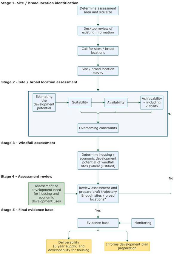
1 Introduction
1.1 The need to build new homes to meet the future needs of a growing population is one of the biggest planning issues facing most local planning authorities and Tendring is no exception. More than ever before, there is a
pressure on local authorities not only to identify sites for housing development but also to ensure that those sites will realistically deliver the number of homes required within a set period to meet objectively assessed needs.
1.2 With the introduction of the National Planning Policy Framework (NPPF) in 2012 and ongoing reforms to other elements of the national planning system, Tendring District Council has been engaged in the process of
preparing a new Local Plan to guide future development in the district, including new housing.
1.3 A Strategic Housing Land Availability Assessment (hereafter referred to as a ‘SHLAA’) is an essential part of the ‘evidence base’ that is needed to inform and underpin decisions on allocating sites for housing in Local
Plans. The primary purpose of the SHLAA is to:
identify sites and broad locations with potential for housing development;
assess their housing potential; and
assess their suitability for development and the likelihood of development coming forward.
1.4 It is important to point out that the SHLAA is not a planning document in its own right and does not dictate which areas of land should be allocated for development, but it is one piece of evidence, amongst others,
containing information that should be taken into account when preparing the Local Plan itself.
1.5 The assessment has been undertaken by officers of the Council and will be subjected to scrutiny and input from a number of key technical stakeholders to ensure its robustness and verify its assumptions prior to the
examination of the Local Plan. The assessment has a statistical base date of 1st April 2018.
1.6 The methodology used to undertake the assessment is compliant with the government’s ‘Planning Practice Guidance’, which was published in 2014 to accompany the National Planning Policy Framework. Where there is a
departure from the guidance the reasons for doing so are set out. In line with the practice guidance, the SHLAA is required, as a minimum, to include the following:
a list of all sites or broad locations considered, cross-referenced to their locations on maps;
an assessment of each site or broad location, in terms of its suitability for development, availability and achievability including whether the site/broad location is viable) to determine whether a site is realistically
expected to be developed and when;
contain more detail for those sites which are considered to be realistic candidates for development, where others have been discounted for clearly evidenced and justified reasons;
the potential type and quantity of development that could be delivered on each site/broad location, including a reasonable estimate of build out rates, setting out how any barriers to delivery could be overcome and
when; and
an indicative trajectory of anticipated development and consideration of associated risks.
1.7 The availability of land for housing can change very quickly for a variety of circumstances and so as part of the ‘plan, monitor and manage’ approach that is key to ensuring plans are flexible and responsive to change, it is
the Council’s intention, as resources allow, to produce an annual review of the assessment to ensure that the data is always as up-to-date as possible. Between 2016 and 2018, the housing supply position in Tendring has
changed rapidly with a substantial increase in sites gaining planning permission for housing, both from the Council and on appeal. It may therefore be necessary to review the assessment on a more frequent basis if the position
continues to change quickly. The findings of the annual update will be reported as part of the Council’s Annual Monitoring Report, which, amongst other things, will include an updated housing trajectory and the latest five-year
supply of deliverable sites.
5
2 Background
National Planning Policy

2.1 In March 2012 the government published the National Planning Policy Framework aimed at making the planning system much more flexible and streamlined, helping to stimulate and promote economic growth and
promoting local decision making and community involvement in the planning process. The National Planning Policy Framework requires all local planning authorities to prepare a ‘Strategic Housing Land Availability Assessment’
(‘SHLAA’) as a key component of the evidence required to underpin an area’s future housing strategy. The primary purpose of the SHLAA will be ‘to establish realistic assumptions about the availability, suitability and the likely
economic viability of land to meet the identified requirement for housing over the plan period’.

The Tendring District Local Plan – 2013-2033 and Beyond: Publication Draft

2.2 On 9th October 2017, the Council submitted its new Local Plan to the Secretary of State to begin the process of examination. The Local Plan has been prepared in partnership with Colchester Borough Council and
Braintree District Council and is formed of two sections. Section 1 is common to all three authorities and sets out the overall joint strategy for growth over the three areas, including the housing and employment targets and the
promotion of new ‘garden communities’ to the east and west of Colchester and to the west of Braintree. Section 1 is, at the time of writing, being examined with the Inspector’s conclusions on soundness expected in May 2018.
The Examination of Section 2, which includes policies and proposals specific to Tendring, is expected to take place towards the end of 2018. Having considered a range of factors including assessments of housing need and
employment potential, the Council determined that the requirement for housing would be a minimum dwelling stock increase of 550 dwellings per annum over the 20 year period 2013-2033 (the plan period) – a total of 11,000
homes. The Local Plan however makes provision for just over 12,000 homes thus incorporating a degree of flexibility. The evidence contained within this assessment demonstrates that the Council can clearly meet the
objectively assessed requirements through the Local Plan.

Objectively Assessed Housing Needs Study (November 2016)

2.3 The National Planning Policy Framework makes it clear that local planning authorities are expected to have a clear understanding of the housing requirements in their area before formulating their future housing strategy
and are therefore required to prepare a ‘Strategic Housing Market Assessment’ (‘SHMA’). Tendring District Council worked jointly with Chelmsford City Council, Colchester Borough Council and Braintree District Council to
commission Peter Brett Associates (PBA) to assess the housing needs across this ‘housing market area’ and for each of the authorities involved. The Objectively Assessed Housing Needs Study (the OAHN study) has
recommended that the ‘objectively assessed need’ for housing in the Tendring District would be 550 dwellings per annum across a range of dwelling size, tenure and type. For the period 2013 to 2033, this equates to 11,000
homes. Much of the demand and need for housing in the district is driven by inward migration – particularly in the coastal towns which are popular for retirement and provide cheaper accommodation for people looking to move
out of more urbanised areas such as East London, South Essex and Colchester. The figures for Tendring were adjusted to take into account an unusual level of ‘unattribatable population change’ (UPC) arising from errors in
either the Census data or the official mid-year population estimates which, in turn, have transferred to the government’s official household projections. The Council’s housing requirement of 550 dwellings per annum is therefore
lower than the government’s official household projections, but for good reasons as demonstrated in the OAHN Study. The Council is aware of the government’s draft proposals to introduce a standard methodology for
calculating housing needs which suggests Tendring’s need is 749 dwellings per annum, but this does not properly reflect UPC and has not been formally introduced into the planning system so 550 dwellings per annum is the
correct figure to plan for through the Local Plan. Demographic projections produced by the Office for National Statistics (ONS) in 2017 suggest that the figure could actually be lower, around 480 dwellings per annum but until the
Local Plan Inspector publishes their conclusions, this assessment applies both the OAHN of 550 from the 2016 report and the 480 based on the more up to date demographic evidence.

Economic Development Strategy, Employment Land Review and Retail Study

2.4 In 2013, the Council commissioned consultants Regeneris to prepare an Economic Development Strategy aimed at identifying the key measures that would stimulate economic growth in the district and facilitate the
creation of new jobs. Amongst the objectives identified in that strategy, one was to facilitate population growth through the construction of new housing to stimulate growth in the service sector economy. Without a significant
increase in housing development, the strategy concluded that it would be difficult to retain existing employment opportunities and attract inward investment. The Economic Development Strategy also identified Clacton, Harwich
and West Tendring/Colchester as the areas with the greatest potential for economic growth and the areas where significant levels of housing development, alongside other measures, would best support economic growth.

Infrastructure Delivery Plan

2.5 The 2017 Infrastructure Delivery Plan (IDP) was prepared by Troy Planning + Design and Navigus Planning to ascertain the infrastructure impacts of the proposed levels of growth in the new Local Plan, identify the level
of investment needed to address any impacts and therefore provide the baseline evidence to justify the use of Community Infrastructure Levy (CIL) and/or s106 agreements to secure infrastructure improvements. The findings in
the IDP have been taken into account as part of this assessment. The Council is proposing to update this evidence in 2018.

Housing Viability Study

2.6 Viability is a key consideration when assessing the housing potential of sites. Viability can be affected by a range of factors including construction costs, site conditions, property prices, the general housing market, planning
policies and requirements for Community Infrastructure Levy (CIL), s106 agreements, affordable housing or specific design standards. In 2017, the Council commissioned Three Dragons and Troy Planning + to test the
economic viability of housing development in different parts of the district looking at different housing densities and infrastructure requirements. This study has also informed the SHLAA assessment. The Council is proposing to
update the viability evidence in 2018.

                                                                                                                                                                                                                                   6
3 The Methodology
3.1 The following diagram illustrates the methodology contained in the 2014 Practice Guidance to the NPPF that has guided the preparation of this assessment:

                                                                                                                                                                7
Stage 1: Site / Broad Location Identification
Determining assessment area and site size
Geographic coverage
3.2 The Practice Guidance states that the area selected for the assessment should ideally be the housing market area, which for Tendring also includes Chelmsford, Colchester and Braintree. It has not been practical for this
assessment to be undertaken for the wider housing market area and therefore this assessment covers the Tendring district only. However, it does reflect the joint work that has taken place across Tendring, Colchester and
Braintree, including the growth proposed for the garden communities – one of which crosses the Colchester/Tendring border.
Minimum site size
3.3 The Practice Guidance states that local authorities will need to assess a range of different site sizes from small-scale sites to opportunities for large-scale developments such as village and town extensions and new
settlements where appropriate. The guidance states that the assessment should consider all sites and broad locations capable of delivering five or more dwellings; however, plan makers may consider alternative site size
thresholds. It was considered that the site-size threshold used in this assessment would form the basis for identifying individual sites for specific allocation for housing (or mixed-use development including an element of housing)
in the new version of the Local Plan. In determining a site-size threshold that was suitable and appropriate for Tendring a number of factors were taken into account including the need to deliver affordable housing, the dispersed
nature of the district and the resources available to carry out a proportionate but meaningful assessment. It was decided to include only housing sites with the potential for 10 or more (net) dwellings in the assessment, which will
be consistent with the threshold for allocating specific sites in the new version of the Draft Local Plan. The assessment does however look at the supply of housing on smaller sites through the use of a projection-based trajectory
which takes into account historic development rates and the supply of small sites with planning permission.
Determining where to search for sites / broad locations
3.4 In a district as geographically diverse and dispersed as Tendring, it was important to establish some clear parameters to guide the initial search for sites to ensure the survey remained cost-effective and manageable and to
avoid any unnecessary speculation from landowners, developers and the general public. Early on in the preparation of a new plan for Tendring, it became clear that a large proportion of the future growth required in Tendring
would need to be provided on ‘greenfield’ land due to the lack of suitable ‘brownfield’ land in the district. It also became apparent early on that new growth for Tendring was likely to take place in the form of new
neighbourhoods/urban extensions around the periphery of existing settlements. Consequently, it was logical to align the search for sites in this assessment with the settlements that are considered to be suitable and sustainable
for peripheral expansion in the new Local Plan, informed by the revised settlement hierarchy contained within Policy SPL1. Accordingly, the search for land in this assessment is focused on the following settlements categories:
‘Strategic Urban Settlements’ (Clacton, Harwich and the Tendring Colchester Border Garden Community), ‘Smaller Urban Settlements’ (Frinton/Walton, Manningtree, Lawford and Mistley and Brightlingsea), and ‘Rural Service
Centres (Alresford, Elmstead Market, Great Bentley, Little Clacton, St. Osyth, Thorpe-le-Soken and Weeley). Sites elsewhere do not form part of this assessment unless they have already obtained planning permission for 10 or
more dwellings and are expected to contribute towards housing supply. Recent appeal decisions have supported the Council’s approach – in particular an Inspector’s decision to dismiss an appeal for 118 dwellings on the edge
of Ardleigh, a smaller rural settlement, on the basis that the village provided a limited range of services and facilities and occupants of the new homes would be heavily reliant on private car use.
Determining which sources of sites to include
3.5 Having scoped the possible ‘sources of supply’ listed in the Practice Guidance, it was decided to use the following categories which were considered to be relevant and appropriate for Tendring:
SOURCE 1: House completions since 1st April 2013: i.e. the base data of the OAHN study. 1,939 homes have been created in Tendring in the last four years and these can be deducted from the 11,000 homes required
up to 2033.
SOURCE 2: Large sites with planning permission: i.e. sites with the potential to deliver 10 or more (net) dwellings that have either gained planning permission or are the subject of a Planning Committee resolution to
grant planning permission on completion of a s106 legal agreement. In the last two years, the supply of land with planning permission has increased rapidly as a result of planning decisions by the Council and the
Planning Inspectorate to comply with the government’s policy to boost, significantly the supply of housing. In the NPPF says, in footnote 11, that sites with planning permission benefit from a presumption of being
considered ‘deliverable’ and these larger sites of 10 or more dwellings are expected to make a considerable contribution towards meeting housing need over the plan period, especially over the first five years.
SOURCE 3: Small sites and windfall sites: i.e. sites with potential for 9 or fewer dwellings either with planning permission or likely to come forward as ‘windfall’ sites over the course of the plan period.
SOURCE 4: Local Plan allocations: i.e. sites allocated in the submitted Local Plan for residential or mixed use development that are yet to received planning permission or a Committee resolution to grant planning
permission. The development of these sites is expected to address any residual housing requirement over the period to 2033.
SOURCE 5: Alternative sites: i.e. sites not allocated for development in the Local Plan nor benefitting from planning permission. Many of these are either being promoted by landowners and developers through objections
to the Local Plan, subject of undetermined planning applications or planning appeals, or derived from earlier assessments of housing potential undertaken by the Council. Alternative sites have generally been omitted
from the Local Plan for reasons explained in this assessment.
8Desktop review of existing information
3.6 To make the assessment cost-effective and ensure a proportionate approach to survey work, the use of secondary ‘desktop’ information was valuable in identifying sites to be assessed and informing their detailed
assessment. The Planning Practice Guidance suggests some possible data sources, of which a number have informed this assessment. The main sources of information comes from planning applications, appeal decisions,
Local Plan representations and earlier sieving exercises undertaken in the earlier stages of preparing the Local Plan.
Call for sites / broad locations
3.7 Since 2009, the Council has been inviting landowners, developers and the general public to put forward their ideas and suggestions for sites that could possibly be earmarked for housing (or a mix of uses including
housing) to accommodate Tendring’s future housing growth. These ‘call for sites’ exercises have presented the Council with a large number of sites across the district, some of which have the potential to be future housing
allocations and so are included in this assessment for more detailed consideration. A number of these sites have either gained planning permission or are now the subject of objections to the Local Plan: Publication Draft and will
be considered by the Planning Inspector as part of the examination process.
Site / broad location survey
The Survey Team
3.8 The survey team consisted of Planning Policy Officers from the Council’s Planning Department, each of whom were fully briefed on the assessment methodology and trained in how to handle enquiries from members of
the public or property owners to minimise unnecessary speculation. To ensure consistency in the approach undertaken and information recorded, officers used a standard approach to ascertain the characteristics and housing
potential for each site.
Recording Site Characteristics
3.9 All the sites identified in the desktop review were visited to ascertain the characteristics of the site and check the potential constraints that were identified in the desktop review (as well as identifying any further constraints
that might not have been identified at the desktop review stage). For each site, the following information was recorded:
site size, boundaries and location;
current land use(s) and character;
surrounding land use(s) and character;
physical constraints (e.g. access, contamination, steep slopes, potential for flooding, natural features of significance, location of infrastructure / utilities);
potential environmental constraints;
where relevant, development progress (e.g. ground works completed, number of homes started, number of homes completed); and
initial assessment of whether the site is suitable for housing or housing as part of a mixed-use development.
Recording the site information
3.10 Each site included in the assessment has a unique reference code that firstly reflects whether the site is classified has planning permission (in which case it is identified by the relevant application number), a Local Plan
allocation (identified by the policy number in the Local Plan) or an alternative site (referenced ALT1, ALT2 etc).
Stage 2: Site / Broad Location Assessment
Estimating the housing potential of each site
3.11 Housing potential is a significant factor that not only determines how much land will be required to deliver overall district housing requirements but, at a site specific level, it can heavily influence economic viability and the
likelihood of a site being deliverable. Consequently, quantifying the supply involved the generation of indicative capacities for each of the identified sites and broad locations. The potential capacity of sites was estimated using a
combination of the following methods:
existing intelligence (i.e. planning permissions, appeal proposals or estimates provided by third parties as part of their ‘call for sites’ proposal);
density multipliers (i.e. where a gross density is used that is based on the size and location of the site); and
design-based approach (i.e. exploring possible designs and layouts taking into account unique site characteristics and physical constraints to determine the resulting density of the site).
3.12 This assessment includes a number of sites being promoted for development by ‘third parties’ (i.e. landowners, developers or agents). Some promoters, in their submissions, have provided their own estimates of the
capacity of their sites but it is clear that different promoters have used different approaches to calculate their estimates. Some have applied a broad density across the whole site area (with many relying on the now abolished
national minimum density to calculate site capacity) whilst others have used more sophisticated methods. In calculating the housing potential of the sites promoted by third parties, the site capacities suggested by the site
promoters were taken into consideration but in many cases the final figure included in this assessment may differ from that originally promoted.
93.13 The Practice Guidance advises that the process of calculating site capacities should be guided by local policy on housing densities. Therefore, in accordance with the policies in the 2012 Draft Local Plan, indicative
densities have been influenced by a number of factors, including the site’s accessibility to local services, housing and private amenity space standards, the required mix of housing, the character of development in the immediate
area, and on-site infrastructure requirements that will need to be incorporated into the layout of the development (including green infrastructure, highways and any community facilities). The general approach for sites within
existing urban areas has been to apply a density multiplier of 30 dwellings per hectare. Because one of the Council’s top priorities is to deliver a lower density of development that provides spacious, more aspirational, properties
with larger gardens and wider streets, the general approach to calculating potential density on a large, typical greenfield site is to apply a density multiplier of 25 dwellings per hectare to 90% of the developable site area (to allow
for the provision of open spaces and other infrastructure) around the district’s larger urban settlements (Clacton, Colchester Fringe, Harwich and Frinton/Walton) and a density multiplier of 20 dwellings per hectare around the
smaller urban areas of Manningtree, Lawford and Mistley, Brightlingsea and the villages.
Assessing when and whether sites are likely to be developed
3.14 One of the main outputs of this assessment is to provide a judgement on the ‘deliverability’ and ‘developability’ of the sites being assessed over the plan period. The Practice Guidance states that for a site to be
‘deliverable’, it must be:
available now;
offer a suitable location for housing development now; and
be achievable with a realistic prospect that housing will be delivered on the site within five years and in particular that development of the site is viable.
3.15 Furthermore, for a site to be considered ‘developable’, it must be:
in a suitable location for housing development; and
have a reasonable prospect that it will be available and could be viably developed at a specific point in time within the plan period.
3.16 In order to determine whether a particular site is deliverable, developable or not currently developable, the assessment looks at:
a) suitability;
b) availability; and
c) achievability.
a) Suitability
3.17 A site is deemed suitable if it offers a suitable location for development and would contribute towards the creation of sustainable, mixed communities, either now or in the future. The suitability of a site was assessed by
considering whether there were any policy restrictions (looking at both the Council’s 2007 adopted Local Plan and the 2017 publication version and national planning policy), physical problems or limitations, potential impacts
and environmental conditions. Sites allocated for housing or a mix of uses that includes housing in the existing adopted Local Plan (or the emerging Draft Local Plan) or with planning permission for housing have generally been
considered suitable for housing unless circumstances have changed that might suggest housing is no longer suitable. In this assessment, the following factors were considered for each site:
Policy constraints;
Physical limitations or problems – such as access, infrastructure, ground conditions, flood risk, hazardous risks, pollution or contamination;
Potential impacts – including the effect upon landscapes including landscape features, nature and heritage conservation;
Appropriateness and likely market attractiveness for the type of development proposed;
Contribution to regeneration priority areas; and
Environmental/amenity impacts experienced by would be occupiers and neighbouring areas.
b) Availability
3.18 A site is considered available where the Council was confident, on the best information available, that there were no legal or ownership problems likely to hinder or delay development. Under this section, the assessment
looked at the following factors for all identified sites:
Ownership;
Ransom Strips;
Operational Requirements;
Restrictive Covenants; and
Development Options.
10c) Achievability
3.19 A site is considered achievable for development where there is a reasonable prospect that housing will be developed on the site at a particular point in time – which is essentially a judgement about the economic viability of
a site and the capacity of the developer to complete and let or sell the development over a certain period. Under this section, the assessment looks at the following factors for all identified sites:
The Housing Market;
Development Costs;
Economic Viability; and
Delivery Factors.
d) Overcoming Constraints
3.20 Where the assessment has identified particular constraints to development through sections a, b and c above, a judgement has been made as to what action would be needed to remove them and when they could be
overcome. It could be, for example, that a site that has no obvious safe access point may require the acquisition of some adjoining land, which as a consequence may affect the overall viability of a scheme. It could be that
landscape improvements, relocation of biodiversity or land remediation may be required or a mixed development solution to overcome local deficiencies in certain services. For each site, the Council’s observations have been
recorded in the final conclusions, listing any measures required to overcome identified constraints.
Judgement as to when and whether sites are likely to be developed
3.21 For each site, based on the intelligence gathered and the assessment undertaken in accordance with the above steps, a judgement as to the likelihood of development and the possible timing of that development has been
made. In terms of assessing the potential timing of development, this assessment recognises four time periods:
2018-2023 – the ‘five-year’ period (1-5) in which Council’s are required to identify specific deliverable sites to meet objectively assessed requirements plus an appropriate buffer;
2023-2028 – years 6-10 of the plan period for the new version of the Local Plan – for which Councils are required to identify specific housing sites or broad areas;
2028-2033 – years 11-15 of the plan period – for which Councils are expected to identify specific sites or broad areas, where possible.
Stage 3: Windfall Assessment
Determining the housing potential of windfall (where justified)
3.22 The assessment of specific sites focuses on locations in and around the district’s Urban Settlements, Strategic Rural Service Centre and Rural Service and only sites with potential for 10 or more dwellings. However, in
reality, a significant number of new homes will also come forward on currently unidentified smaller sites of 9 or fewer and unidentified sites in some of the district’s ‘Smaller Rural Settlements’ and there are also a large number
of long-term empty homes in the district that will come back into use as the economy strengthens and the housing market picks up. Whilst it is not possible or practical to identify and assess every potential windfall, there is
strong evidence to suggest that they will make an important contribution toward housing supply in the district, particularly over the next 5 years.
Stage 4: Assessment Review
Presenting the findings of the assessment
3.23 For each site included in the assessment, a standard schedule has been filled in containing the following headings:
SITE ADDRESS Grid Area Estimated Planning Status Physical Environmental Infrastructure Ownership Viability Issues Suit- Avail- Achievable? / Other Comments
CODE Ref (ha) Dwelling Capacity Constraints Constraints Constraints Issues able? able? Likely Timescale
The The site address The Site Estimated number An indication of whether the Any Any observations Any Any intelligence Any observations on , ? , ? If a site is Any final observations about the
unique including postcode. Ordnance area in dwellings capable of site was in the Local Plan, had observations on on environmental observations on on ownership factors that might achievable an deliverability of the site.
or X or X
code Survey grid hectares being achieved planning permission, was physical constraints infrastructure issues that might affect the economic estimate of when
for the reference for (in most based on a density included in a master plan, constraints affecting the site. constraints affect the viability of a site and development
site. each site cases estimate or other submitted by a third party etc. affecting the affecting the availability of the whether it is might take place is
(usually the this will intelligence about site. site. site. achievable, or not. given.
mid-point of be an the site.
the site). approxi
mate
value)
113.24 In concluding whether a site is ‘suitable’ and ‘available’ and ‘achievable’, a indicates ‘yes’, a ? indicates some uncertainty and a X indicates ‘no’. The results of these assessments are included in Appendices 1 to 4 to this
report. For each site there is then a ‘trajectory’ indicating the estimated number of dwellings that could realistically be built in each financial year between 2017/18 and 2032/33. This follows the format below.
YR1 YR2 YR3 YR4 YR5 YR6 YR7 YR8 YR9 YR10 YR11 YR12 YR13 YR14 YR15
Site Ref Site name Total 2018/ 2019/ 2020/ 2021/ 2022/ 2023/ 2024/ 2025/ 2026/ 2027/ 2028/ 2029/ 2030/ 2031/ 2032 Next Notes
capacity 19 20 21 22 23 24 25 26 27 28 29 30 31 32 -33 plan
MANNINGTREE/LAWFORD/MISTLEY
Site 1 Summarised version of the full address. 10 2 2 2 2 Delivery in years 1-5
Site 2 Summarised version of the full address. 20 OUT RM DC/C 4 4 4 4 4 Delivery in years 6-10
Site 3 Summarised version of the full address. 30 6 6 6 6 6 6 Delivery in years 11-16
Site 4 Summarised version of the full address. 40 8 8 8 8 8 8 Delivery in years 11-16
Site 5 Summarised version of the full address 50 50 Delivery likely to be longer term or not at all.
3.25 Homes estimated to be delivered between 2018/19 and 2022/23 are shown in green as there is strong evidence to suggest development will take place in the short term. Amber indicates homes expected in years 6
onwards. The pre-development stages involved in the planning process are also indicated for most sites with the following key.
LPA Local Plan adoption
OUT Outline consent
FUL Full consent
RM Reserved matters approval
HCC High Court challenge
DC Discharge of conditions
C Commencement of development
Stage 5: Final Evidence Base
3.26 The findings of this assessment will help to inform the examination of the Local Plan and future reviews, which will contain specific housing allocations to deliver the amount of new housing required over a 15 year plan-
period to meet the objectively assessed housing need for the district. This specific version of the SHLAA will inform potential modifications to Section 2 of the Local Plan designed to ensure the plan is up to date and reflects
various Council and appeal decisions that have been made since the publication of the plan in 2017. It is also important an annual update is carried out to ensure the Council continuously has a 5-year housing supply, in
accordance with the National Planning Policy Framework, and to have enough land identified in the event of an undersupply. In accordance with the practice guidance, this Assessment will be reviewed and updated on an
annual basis (as part of the Council’s Annual Monitoring Report) in order to monitor the district’s housing supply and the delivery and effectiveness of the new Local Plan. This will include a judgement as to whether sites will
come forward as anticipated and whether further sites need to be sought or original assumptions made about sites as part of this assessment, need to be revisited, in the event of an undersupply.
124 Assessment Conclusions
4.1 The following table outlines the main conclusions of the SHLAA assessment.
Years 1-5 Years 6-10 Years 11-16
Source of housing supply 2013-2018 2018-2023 2023-2028 2028-2033 TOTAL Notes
(5 years) (5 years) (5 years) (5 years)
Objectively Assessed Need
Housing requirement 1,939 4,273 2,394 2,394 11,000 550 homes a year is the recommended OAN for Tendring within the 2016 OAN Study. The Council’s
(actual) submitted Local Plan reflects this requirement by planning for a minimum 11,000 homes over the 20-year
period 2013-2033. The requirement within years 1-5 (the five-year supply) is greater than years 6-10 and
years 11-16 because, in line with the NPPF’s requirement to boost the supply of new homes, it must include
provision for the 2013-2017 undersupply plus a 20% buffer (reflecting the fact that Tendring has seen
persistent under-delivery of housing in recent years). If however the Council achieves its housing requirement
in three consecutive years, the buffer can be reduced to 5%.
SOURCE 1: COMPLETIONS SINCE 2013
Supply of homes 1,939 0 0 0 1,939 House completions since April 2013 have already delivered just over 1,900 homes and have therefore
reduced the residual housing requirement for the period up to 2033 to around 9,100. To meet its objectively
Residual requirement - 4,273 2,394 2,394 9,061 assessed housing needs over the plan period to 2033 and therefore meet the requirements of the NPPF, the
Council must identify sufficient land, through the Local Plan, to deliver this residual requirement.
SOURCE 2: Large Sites with planning permission
Supply of homes - 3,540 1,465 100 5,105 Deliverable large sites with planning permission for housing and mixed-use development are expected to
contribute around 5,100 homes, thus addressing more than half the residual housing requirement up to 2033.
The majority of this development is expected in years 1-5 but will not address the five-year requirement in full
Residual requirement - 733 929 2,294 3,956 which must include provision for the 2013-2018 undersupply plus a 20% buffer, as required by the NPPF.
Large site with planning permissions will also deliver a fair number of homes in years 6-10 but the supply
drops off in years 11-16 as these sites are completed.
SOURCE 3: Small sites and windfalls
Supply of homes - 660 361 174 1,195 Small sites and other windfall sites are expected to contribute around 1,200 homes in the period to 2033 thus
reducing the residual housing requirement to around 2,800. These sites will address a large part of the
residual five-year requirement, but there remains a small 73-home shortfall The supply of small sites and
Residual requirement - 73 568 2,120 2,761 windfall sites is expected to dry out over the plan period, so their contribution to years 6-10 and 11-16 will
reduce significantly.
SOURCE 4: Housing allocations in the emerging Local Plan
Supply of homes Based on the up to date assessment contained in this document, the sites specifically identified in the
- 449 1,824 1,845 4,118 submitted Local Plan for housing or mixed-use development are expected to contribute just over 4,100 homes
in the period to 2033 thus addressing the residual requirement over the plan period with almost 1,400 to spare.
Total Surplus/Deficit - 376 1,256 (275) 1,357 Some of these sites are expected to obtain planning permission in the short term, enabling them to contribute
towards the five-year requirement and addressing any shortfall.
4.2 The results of the SHLAA assessment show that it is realistic to comfortably address the full objectively assessed need for housing through the deliverable supply of sites, including an allowance for small sites and windfalls.
Sufficient land can be identified to address the five-year requirement which, including historic shortfall since 2013 and a 20% buffer as required by the NPPF. Over the full plan period, there is a potential surplus of land and the
Local Plan therefore identifies sufficient land to deliver an oversupply of nearly 1,400 homes.
4.3 The SHLAA demonstrates that around 1,900 of the 11,000 homes needed up to 2033 have already been built. Large sites with planning permission and small sites (mostly benefitting from planning permission) can together
deliver around 6,300 homes leaving around 2,800 homes to be planned for through allocations in the Local Plan. The publication draft identifies more than enough deliverable land to meet this residual requirement which would
indicate that the plan is sound in respect of housing supply.
134.4 The following tables analyse the housing potential by settlement and by sources of supply.
Source of supply Supply from large site planning Supply from Local Plan Grand % increase % of total Average
permissions and small allocations Total in dwellings rate of
site/windfalls settlement planned for housing
Settlement/location Years Years Years Total Years Years Years Total dwelling completions
1-5 6-10 11-16 1-5 6-10 11-16 stock 2018-2033
(approx.) per annum
Clacton 651 377 0 1,028 185 765 1,095 2,045 3,073 11% 29.5% 205
Harwich 208 100 100 408 149 248 0 397 805 9% 7.7% 54
Frinton and Walton 489 337 0 826 0 87 0 87 913 9% 8.9% 62
Manningtree, Lawford and Mistley 617 390 0 1,007 0 0 0 0 1,007 25% 9.7% 67
Brightlingsea 166 0 0 166 0 0 0 0 166 4% 1.6% 11
Colchester Fringe 120 0 0 120 0 500 750 1,250 1,370 N/a 13.1% 91
Alresford 225 24 0 249 0 0 0 0 249 30% 2.4% 17
Elmstead Market 170 14 0 184 0 0 0 0 184 25% 1.8% 12
Great Bentley 229 45 0 274 0 0 0 0 274 39% 2.6% 18
Little Clacton 86 38 0 124 35 0 0 35 159 16% 1.5% 11
St. Osyth 121 140 0 261 0 0 0 0 261 28% 2.5% 17
Thorpe le Soken 187 0 0 187 0 0 0 0 187 28% 1.8% 12
Weeley 14 0 0 14 80 224 0 304 318 70% 3.0% 21
Smaller Rural Settlements 257 0 0 257 0 0 0 0 257 N/a 2.5% 17
Small Sites/Windfall 660 361 174 1,195 - - - 0 1,195 N/a 11.5% 80
TOTALS 4,200 1,826 274 449 1,824 1,845 4,128 10,428 100% 678
4.4 Through a combination of large sites with planning permission, small sites/windfalls and allocations in the emerging Local Plan, the residual requirement of 9,061 dwellings can be comfortably met. In line with the settlement
hierarchy in the Local Plan, the strategic urban settlements of Clacton and Harwich, the Colchester Fringe/Tendring Colchester Borders Garden Community and the smaller urban settlements of Frinton/Walton,
Manningtree/Lawford/Mistley and Brightlingsea are expected to accommodate the majority of new development.
Clacton
4.5 Clacton, being the district’s largest settlement, would deliver around 3,100 homes, some 29% of the district requirement and a 11% increase on the town’s existing dwelling stock. Proposals in the Local Plan include new
primary schools at the Rouses Farm, Hartley Gardens and Oakwood Park developments to meet the increasing needs. Secondary school provision can be addressed through expansion at existing campuses. The large scale
allocations also propose medical centres which would be subject to NHS approval in line with its emerging strategy for primary healthcare provision. In terms of transport infrastructure, the Hartley Gardens scheme includes a
link road around the north-west of the town and the Council’s transport modelling identifies improvements to key road junctions, including at St. John’s Roundabout. Growth in Clacton is expected to take place at a fairly steady
rate throughout the plan period averaging around 200 dwellings per annum. Since 2001, the average rate of house completions in the Clacton area has been around 170 a year, fluctuating between 100 and 300, so the
anticipated increase in the rate of growth to 180 a year is reasonably achievable in the plan period to 2033. The emphasis on economic growth in the Clacton area is supporting existing businesses to expand, improving the retail
and leisure offer through developments in the town centre, at Brook Park West and at Clacton Factory Shopping Village. Investing in tourism, regenerating Jaywick Sands and supporting innovation in the care and assisted living
sectors are also key elements of the economic strategy.
Harwich
4.6 Harwich and Dovercourt, with a weaker housing market and more physical and environmental constraints is expected to deliver 800 homes up to 2033 which is around 7% of the district requirement and a 9% increase on
the town’s existing dwelling stock. This level of development can be accommodated without the need for any new schools or surgeries or any significant highways infrastructure. The growth is expected to take place mainly in
the middle part of the plan period but the average rate over the next 15 years would be around 50 homes a year. The average since 2001 has been around 60 a year fluctuating significantly between 30 and 200. There is a
strong emphasis on delivering new inward investment and employment opportunities in the Harwich area to drive economic growth including those linked to the renewable energy sector.
Colchester Fringe/Garden Community
4.7 The development immediately on the Colchester Fringe at the Avellana Place development is expected to deliver 120 homes within the next five years whereas the development at the Tendring Colchester Borders Garden
Community is anticipated to deliver homes in years 6-10, 11-16 and beyond. The 1,250 included in the SHLAA would represent a 50:50 share of the total 2,500 anticipated for the Garden Community up to 2033 being allocated
to Tendring’s requirement. With the Local Plan over-allocating by some 1,200 homes, there is significant flexibility incorporated into the plan to guard against any delays or under-supply in the Garden Communities project. Close
links to the growth at the University of Essex and promoting technological innovation are key strands of the economic strategy to deliver jobs alongside housing in this location. This location is expected to deliver around 13% of
the district’s total planned growth but with significant longer-term potential beyond 2033. .
14Smaller Urban Settlements
4.8 Frinton and Walton, including Kirby Cross, are expected to deliver around 900 homes of which the vast majority have already obtained planning permission. Development in Walton on the Naze is to be supported by new
investment in retail and tourism. An average rate of development around 60 homes a year over the plan period is broadly in line with the rates of 30 to 90 completions a year achieved since 2001. The Manningtree, Lawford and
Mistley area is expected to accommodate more than 1,000 homes which represents a considerable increase in the settlement’s housing stock and reflects the area’s popularity, its attractive environment and its good mainline
rail links. The developments have already obtained planning permission and are expected to deliver over years 1-10. The average rate of development over the plan period would be around 70 completions a year and historic
rates of development would suggest this is achievable. The level of development proposed for Brightlingsea is significantly lower at just under 166 homes but this reflects the town’s environmental sensitivities and its limited
transport infrastructure with no rail services and one road in and one road out.
Rural Service Centres
4.9 The rural service settlements including Arlesford, Elmstead Market, Great Bentley, Little Clacton, St. Osyth, Thorpe and Weeley would each accommodate something in the region of 150 to 300 dwellings. However, it should
be noted that the percentage increases in dwelling stock for these locations are considerably higher than in the urban settlements. Many of the developments were allowed on appeal at a time when the Council was unable to
demonstrate a five-year supply of deliverable housing sites and the government’s presumption in favour of sustainable development had to apply. The higher levels of development proposed in Alresford, Great Bentley and
Weeley reflect their locations on the transport network, particularly with branch line rail services. The majority of development in St. Osyth is associated with St. Osyth Priory and is enabling development to fund its restoration.
With higher property values in these villages, the majority of the development is anticipated in years 1-5. There is a concern about too much development being accommodated by these settlements and resulting in an overly
disproportionate level of growth taking place, but as the most sustainable rural locations for development, a modest proportion of total housing (around 1,900 homes and 18% of the district requirement) is planned for villages in
this tier of the settlement hierarchy.
Smaller Rural Settlements
4.10 Smaller rural settlements are expected to accommodate a relatively small proportion of the district’s overall growth which reflects their limited access to jobs, shops, services and facilities at just over 250 dwellings.
Alternative sites and alternative OAN requirements
4.11 There are a number of objections to the submitted Local Plan which will be addressed through the examination process – many of which relate to housing supply and the objectively assessed housing needs. Some argue
that the housing requirement should be higher and that additional land should be allocated in the Local Plan to address this. The SHLAA has assessed a number of ‘alternative sites’ that are not currently allocated in the Local
Plan to test their suitability, availability and likely deliverability. This issue has already been debated as part of the examination of Section 1 of the Local Plan and the Inspector’s conclusions are expected in May 2018. The
Council expects that the Inspector will endorse the current OAN of 550 or a lower figure of 480 which reflects the latest demographic projections from the Office for National Statistics. However, if the Inspector concludes that a
higher OAN should apply, the assessment of alternative sites in this SHLAA provides some guidance as to how this could potentially be addressed.
4.12 If the OAN were increased to 600 dwellings per annum and the total requirement for the plan period 2013-33 was 12,000, the SHLAA demonstrates that the allocations in the Local Plan combined with planning
permissions, small sites and windfalls are sufficient to meet the requirements with a surplus of around 400 homes. If OAN was increased to between 650 to 750 dwellings per annum (reflecting some of the suggestions made by
objectors to the Local Plan), the requirement for the plan period 2013 to 2033 would increase to between 13,000 and 15,000 homes for which an additional 1,000 to 4,000 homes would need to be planned for through the
inclusion of addition sites in the Local Plan.
4.13 The assessment of alternative sites indicates a potential to deliver a further 1,000 homes without having to adjust the settlement development boundaries in the Local Plan. The land around Clacton north of the Brook Park
West scheme, at Foots Farm and Lotus Way along with the redevelopment of Navyard Wharf in Harwich could deliver these additional homes. Therefore increasing the OAN to 650 and the requirement to 13,000 homes could
be addressed without any substantial changes to the plan.
4.13 If the housing requirements increased to around 14,000 over the plan period, additional greenfield sites around the district’s towns or rural service centres could deliver around 800 homes but these would be on more
sensitive greenfield sites on the edge of settlements when changes to the Local Plan and the infrastructure delivery plan would be required. Alternatively the district’s rural service centres could potentially accommodate a further
700 homes, however this would certainly result in disproportionate levels of development around Elmstead Market, Great Bentley and St. Osyth and accepting development on some sites where permission has previously been
refused or where appeals are in the process of being determined. All such options would involve the loss of sensitive greenfield land on the edge of these settlements and would raise serious questions about their ability to
maintain their individual rural character. The government’s pooling restrictions on securing financial contributions from s106 agreements (allowing no more than 5 per piece of infrastructure) would also restrict the Council’s
ability to fund necessary increases in the capacity of rural schools and health centres and the option of new schools, new health facilities and significant highways improvements would need to be assessed again.
4.14 To achieve a housing requirement of 15,000 over the plan period, the Council would also have to consider either reintroducing the concept of major strategic expansion of Weeley or release sites from the strategic green
gaps designated around some of the district’s urban settlements. Strategic growth at Weeley was proposed at preferred options stage but subsequently deleted from the Local Plan at publication stage, in response to significant
local objection and revisions to the housing numbers. The assessment suggests that an additional 600 homes might be achievable within the plan period to 2033 by releasing land to the north of the village with a further 800
homes in the longer term on land to the west. Releasing land from Strategic Green Gaps would have significant implications for the communities in Little Clacton, Sladbury’s Lane and Holland on Sea, Kirby le Soken and
Lawford and Mistley. Green Gap sites could potentially deliver around 1,500 additional homes within the plan period but would have significant environmental impacts on character of these communities. Either option of
development at Weeley or in the Strategic Green Gaps would also bring about the need to build additional schools, medical facilities alongside significant highways and utilities infrastructure.
15Summary of conclusions
4.15 This assessment confirms that the policies and proposals in the submitted Local Plan when combined with site with planning permission on large and small sites, and windfall sites, can reasonably ensure than 11,000
homes are delivered in Tendring in the period 2013-2033 in line with the recommendations in the OAN Study. The Local Plan over-allocates by around 1,400 homes which helps to guard against any under-delivery on certain
sites or potential delay on larger strategic schemes including the Tendring Colchester Garden Community. The Council is also able to demonstrate a five year supply of deliverable housing sites in line with the requirements of
the NPPF.
4.17 The OAN Study advises against increasing housing delivery above 11,000 with concerns over a potential mismatch between population growth and job opportunities. However, if the requirement was increased to 12,000,
the Local Plan already identifies sufficient land to deal with this requirement. If the requirement needed to increase further, the following options would be available to the Council in sequential order of preference in planning and
sustainability terms:
1. Development on sites within the defined settlement development boundaries of Clacton and Harwich including land north of Brook Park West, land at Foots Farm, land at Lotus Way, Jaywick Sands and the
redevelopment of Navyard Wharf.
2. Allocating additional land around Clacton, Harwich, Walton on the Naze, Mistley, Lawford and Brightlingsea with mitigation measures to minimise the impact on landscape character and infrastructure.
3. Allocating additional land around rural service centres including Great Bentley and Elmstead Market with the consequent impacts on the character of those villages and infrastructure provision.
4. Revisiting the option of strategic growth around Weeley at a scale that can deliver new infrastructure, services and facilities or removing the strategic green gap designation and releasing further sites around Clacton,
Harwich and Frinton/Walton.
5. Assessing the potential of sites around the district’s smaller rural settlements accepting that these offer the least sustainable locations for growth.
16You can also read