Lewisham Local Plan Draft - Regulation 18 stage 'Preferred Approach' Document - Council meetings
←
→
Page content transcription
If your browser does not render page correctly, please read the page content below
Draft
Lewisham Local Plan
Site Allocations – Central area

Regulation 18 stage ‘Preferred Approach’ Document
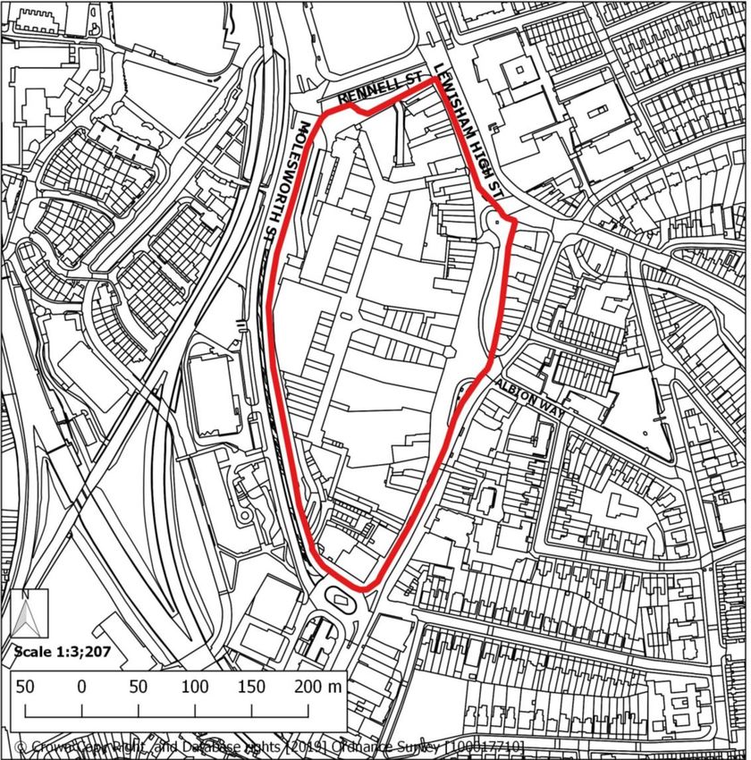
Lewisham Gateway

Site address:    Lewisham Gateway Site, Lewisham High Street, London, SE13
Site details:    Site size (ha): 5.52, Setting: Central, PTAL: In 2015: 6b, In 2021: 6b, In 2031: 6b,
                 Ownership: Mixed public and private, Current use: Transport interchange
How site was     Lewisham Core Strategy (2011) and London SHLAA (2017)
identified:
Planning         Opportunity Area, adjacent to Conservation Area, Critical Drainage Area,
designations     Flood Zones 1 and 2
and site
constraints:
Planning         Full application DC/06/062375 granted in May 2009. Various reserved matters and
Status:          s73 minor material amendment granted April 2013 – February 2019. Started
                 construction and development is partially complete.
Timeframe for    2020/21 – 2024/25      2025/26 – 2029/30     2030/31 – 2034/35 2035/36 – 3039/40
delivery:              Yes
Indicative                 Net residential units:                  Non-residential floorspace:
development                         607                                Town centre: 2,550
capacity:

                                                    1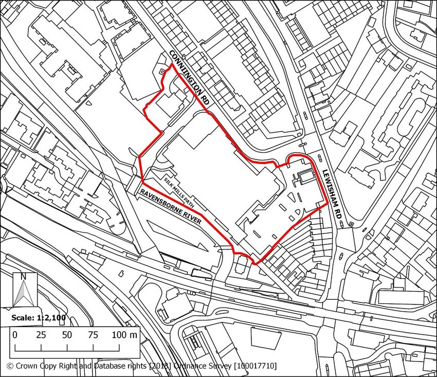
Employment: 17,500
Existing planning consent
DC/06/062375 - The comprehensive mixed use redevelopment of the Lewisham Gateway
Site, SE13 (land between Rennell Street and Lewisham Railway Station) for 100000m²
comprising retail (A1, A2, A3, A4 and A5), offices (B1), hotel (C1), residential (C3),
education/health (D1) and leisure (D2) with parking and associated infrastructure, as well as
open space and water features as follows:
up to 57,000 m² residential (C3)
up to 12,000 m² shops, financial & professional services (A1 & A2)
up to 17,500 m² offices (B1) / education (D1)
up to 5,000 m² leisure (D2)
up to 4,000 m² restaurants & cafés and drinking establishments (A3 & A4)
up to 3,000 m² hotel (C1)
up to 1,000 m² hot food takeaways (A5)
500m² health (D1)
provision of up to 500 car parking spaces
revised road alignment of (part of) Lewisham High Street, Rennell Street, Molesworth
Street and Loampit Vale and works to Lewisham Road.
DC/13/82493 - Approval of Reserved Matters for Block A (comprising Block A1 and A2 of 25
storeys and 15 storeys respectively) to provide a total of 193 residential units (comprising 18
studios, 97 one bedroom, 74 two bedroom and 4 three bedroom units) and 518 sq.m (GEA)
of retail/restaurant/cafe floorspace (Use Class A1 and A3) and open space (including 'Con-
fluence Place') pursuant to condition 2, relating to siting, design, external appearance and
landscaping for the comprehensive mixed use redevelopment of the outline approval
DC/06/62375.
DC/14/89233 - Approval of Reserved Matters for Block B (comprising Block B1 and B2 of 15
storeys and 22 storeys respectively) to provide a total of 169 residential units (comprising 83
one-bedroom units, 82 two-bedroom units and 4 three-bedroom units) and 571sqm (GEA) of
retail/restaurant/cafe floorspace (Use Class A1 and/or A3)), associated hard and soft land-
scaping and related works pursuant to condition 2, relating to siting, design, external appear-
ance and landscaping for the comprehensive mixed use redevelopment of the outline ap-
proval DC/06/62375.
DC/18/105218 - approval of S73 minor material amendment increased the maximum
residential floorspace to 77,326sqm (indicative c.889 units), together with up to 6,409sqm of
co-living floorspace (indicative c.114 units). Of the 889 units, 362 have been delivered as
part of Phases 1A and 1B, with 527 residential units remaining to come forward within Phase
2.
DC/18/109819 – approval of Phase 2 reserved matters for 530 residential units and 119 co-
living units. Of the 530 residential units, 106 will be intermediate tenure (London Living
Rent).
Site allocation
2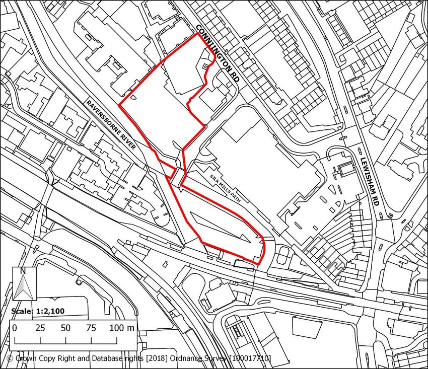
Comprehensive mixed-use redevelopment comprising compatible main town centre,
commercial and residential uses. Delivery of new and improved transport infrastructure
including road realignment, enhanced transport interchanges and pedestrian and cycle
routes. Public realm and environmental enhancements, including new public open space
and river restoration.
Opportunities
Lewisham Gateway is a prominent site within Lewisham major town centre. Comprehensive
redevelopment of the site is necessary to secure the delivery of strategic transport
infrastructure, including the Lewisham interchange and the Bakerloo Line extension, along
with associated public realm improvements. This infrastructure will act as a catalyst for
investment in the local area and help the town centre to achieve metropolitan centre status.
Redevelopment and site intensification, along with the introduction of a wider range of uses,
can provide a more optimal use of land to support the long-term vitality and viability of the
town centre. Redevelopment can also enable public realm and environmental improvements
to be delivered, with key opportunities to reinstate the Rivers Quaggy and Ravensbourne
and to create a more coherent network of pedestrian and cycle routes connecting to the
surrounding area.
Development requirements
Site layout and design must improve access to and permeability across the wider town
centre area. This includes a legible and safe network of pedestrian and cycle routes to
create a direct link between the station and town centre, as well as to enhance
connections between public spaces and surrounding neighbourhoods.
Work in partnership with Transport for London to facilitate the road realignment,
encompassing parts of Lewisham High Street, Rennell Street, Molesworth Street and
Loampit Vale.
Development must not prejudice the delivery of transport infrastructure. Proposals will
be required to safeguard land necessary to secure the delivery of an enhanced station
interchange. This is necessary to improve passenger movement and connections
between buses, trains, the Docklands Light Rail, and the future Bakerloo line extension.
Appropriate provision for the bus layover, currently sited at Thurston Road.
Provision of a mix of main town centre and other complementary uses.
Active frontages with appropriate main town centre uses on the ground floors of
buildings. Residential uses will not be acceptable on ground floor or basement levels.
Delivery of new and improved public realm and open space in accordance with a site-
wide public realm strategy, including:
o A programme of river restoration, including channel re-profiling, to improve
the ecological quality of the water environment and enhance the amenity
provided by the Rivers Quaggy and Ravensbourne, along with Waterlink
Way.
o A central landscaped open space that celebrates the confluence of the rivers
Quaggy and Ravensbourne.
Support conservation objectives for heritage assets including: St Stephen’s Church
(Grade II); St Stephen’s and Belmont Conservation Areas.
3
Development guidelines
Development should set out and reinforce a clear hierarchy of streets and building
heights, both within the site and in response to the wider town centre area, organised
around a high quality public realm.
Buildings should provide for a range of footprint sizes to accommodate a variety of town
centre, commercial and community uses, and be designed to provide flexibility to enable
sub-division of units.
Active frontages should be accommodated at all key sides of the development, including
Molesworth Street and Lewisham Road.
Public realm must be fully integrated into the site area. Particular attention should be
given to key pedestrian locations, including the connections between the station
interchange and High Street to the south, linking Lewisham Gateway to the heart of the
town centre. Proposals should also be designed having regard to their relationship with
adjoining strategic sites, including those at Loampit Vale to the east and Connington
Road to the north.
The Rivers Quaggy and Ravensbourne pass through the site but are culverted and
canalised. Proposals will be expected to investigate and maximise opportunities to
reinstate the rivers and their corridors as a prominent feature in the development, along
with facilitating improvements to Waterlink Way. This should be supported by delivery of
a new coherent public open space which focuses on the confluence of the rivers.
Clear visual links to St Stephen’s Church, situated to the east of the site boundary,
should be established and maintained.
Development must assist in facilitating delivery of strategic transport infrastructure,
including enhancements to the Lewisham interchange and accommodating the future
Bakerloo Line extension. Transport for London proposals for the extension of the
Bakerloo Line provide for the possibility of infrastructure requirements at this site,
including a new ‘station box’, being located partly on the existing bus layover site at
Thurston Road. Applicants must consult with Transport for London and Network Rail to
ensure development makes appropriate provision for transport infrastructure.
A hierarchy of routes both into and through the site should be established. This should
ensure clearly legible routes, including those where pedestrians have priority and where
space may be shared with cyclists and/or motor vehicles.
Car parking provision should be the minimum required to maintain the viability of the
town centre, whilst also reflecting the high level of public transport accessibility of the
site. Where car parking is required it should be positioned to be intuitive to visitors,
minimising the impact of access and egress to pedestrians and other road users.
Provision for servicing vehicles should be located and designed to mitigate impact on
amenity, particularly where there is existing or planned public realm.
4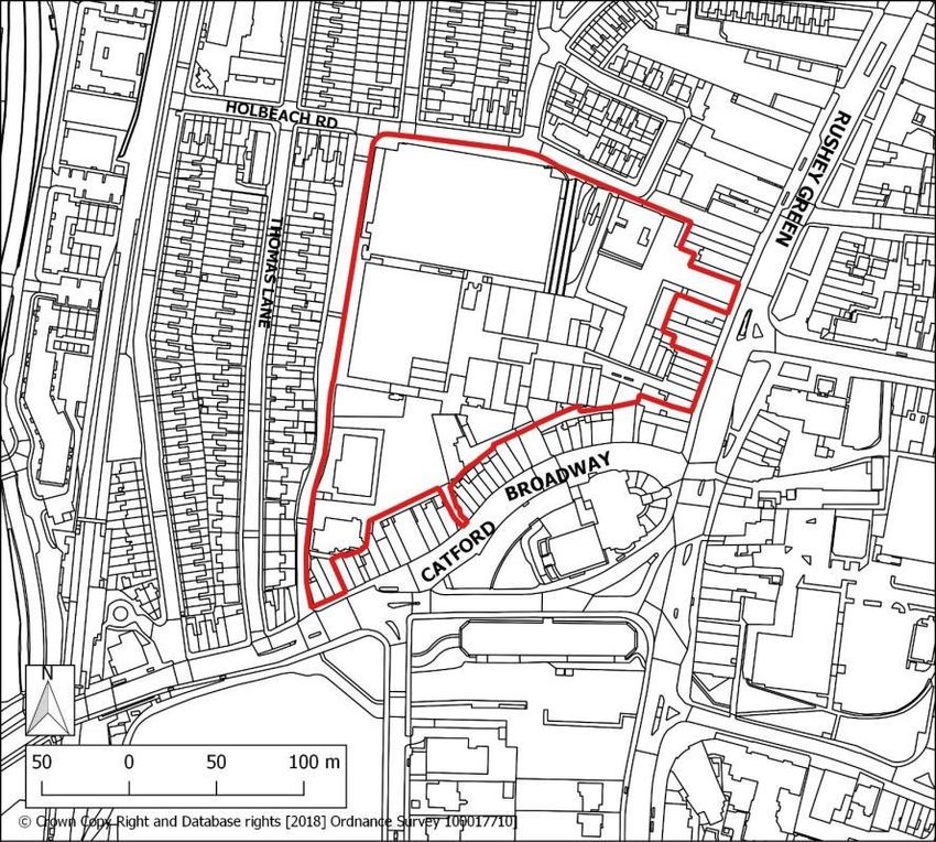
Lewisham Shopping Centre

Site address:   Lewisham Shopping Centre, 33A Molesworth Street, Lewisham, London, SE13 7HB
Site details:   Site size (ha): 6.37, Setting: Central, PTAL: In 2015: 6b, In 2021: 6b, In 2031: 6b,
                Ownership: Private, Current use: Main town centre uses, Retail
How site was    Lewisham Call for Sites (2015 and 2018) and London SHLAA (2017)
identified:
Planning        Opportunity Area, primary frontage within Lewisham major centre, Area of
designations    Archaeological Priority, 3 Locally Listed Buildings on site, Critical Drainage Area,
and site        Flood Zones 2 and 3
constraints:
Planning        None
Status:
Timeframe for   2020/21 – 2024/25      2025/26 – 2029/30      2030/31 – 2034/35      2035/36 – 3039/40
delivery:             Yes
Indicative              Net residential units:                    Non-residential floorspace:
development                      949                                 Town centre: 58,102
capacity:                                                            Employment: 24,901

                                                  5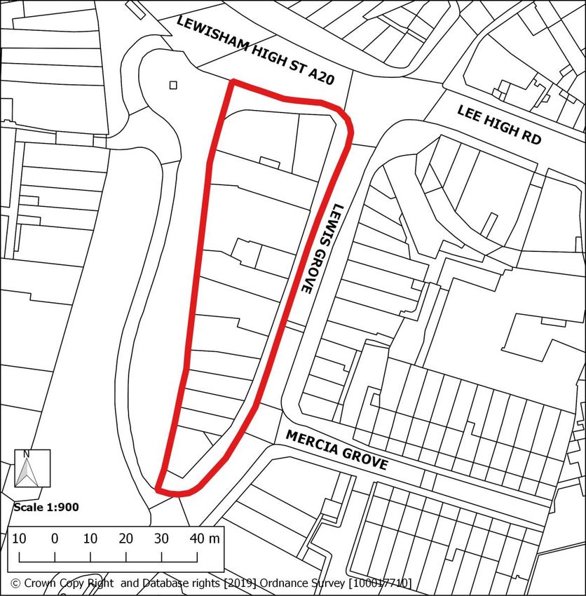
Other: 16,601
Existing planning consent
DC/17/105087 – part of the site, prior approval for the change of use of Lewisham House, 25
Molesworth Street, SE13, from office use (Class B1a) to residential (Class C3) to create 237
units.
Site allocation
Comprehensive mixed-use redevelopment of existing shopping centre comprising
compatible main town centre, commercial, community and residential uses. Redevelopment
of existing buildings and reconfiguration of spaces to facilitate a street-based layout with new
and improved routes, both into and through the site, along with public realm and
environmental enhancements.
Opportunities
This site forms the heart of Lewisham major town centre, including the Lewisham Market,
and is dominated by the Shopping Centre and Citibank office block. It is key to the renewal
and modernisation of the town centre, and will play a critical role in linking sites and
neighbourhoods surrounding it. Comprehensive redevelopment can deliver a significant
amount of new housing together with modern retail and employment space, leisure and
cultural facilities as well as social infrastructure to support the long-term vitality and viability
of the town centre, including the market, and reinforce its role as the borough’s main
shopping and leisure destination. Development can also enable transformative public realm
and access improvements to provide new and enhanced connections to and through the
area.
Development requirements
To reinforce and enhance Lewisham’s role as the principal town centre in the Borough,
and to secure its future status as a Metropolitan Centre of sub-regional significance,
development must provide a mix of new housing, main town centre, commercial and
other complementary uses, including the re-provision and enhancement of Lewisham
Market.
The site must be re-integrated with the surrounding street network to improve access
and permeability into and through the town centre. This will require significant
reconfiguration and re-orientation of the existing buildings and spaces to achieve clearly
articulated east-west and north-south corridors.
Development will be expected to improve east-west connections, including the creation
of new connections between Molesworth Street and Lewis Grove, along with a new
north-south pedestrianised spine running through the site, linking the Lewisham
Gateway and the Engate Street sites.
Active frontages with appropriate town centre uses on the ground floors of buildings will
be required within the Primary Shopping Area and along key routes.
Delivery of new and improved public realm in accordance with a site-wide public realm
strategy, including:
o Improvements to Lewisham High Street and Market square.
o A central landscaped open space
6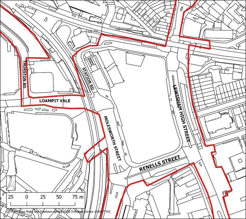
o A network of connections linking to the wider town centre area, including
Cornmill Gardens, the Rivers Quaggy and Ravensbourne, and Blackheath.
Provision of dedicated public toilets appropriate to the scale of development.
Support conservation objectives for heritage assets, including: The Clock Tower,
Lewisham High Street (Grade II); Church of St Saviour and St John Baptist and
Evangelist (RC), Lewisham High Street (Grade II); Former Prudential Buildings, 187-197
Lewisham High Street (Grade II) and St Stephen’s Conservation Area.
Development guidelines
Active frontages should be accommodated adjacent to Lewis Grove and along the new
north-south route through the site from Lewisham Gateway, including the junction with
Molesworth Street to the south. Active frontages should also be introduced along
Rennell Street.
The existing inactive frontage onto Molesworth Street should be replaced and improved.
The frontage should be interspersed with smaller uses, entrances and windows to
create an activate frontage.
Frontages along new river link between Lewisham Road and River, Tertiary frontage
perpendicular to Connington Road
A hierarchy of routes both into and through the site should be established. This should
ensure clearly legible and safe routes, including those where pedestrians have priority
and where space may be shared with cyclists and/or motor vehicles.
Car parking provision should be the minimum required to maintain the viability of the
town centre, whilst also reflecting the high level of public transport accessibility of the
site. Where car parking is required it should be positioned to be intuitive to visitors,
minimising the impact of access and egress to pedestrians and other road users.
Provision for servicing vehicles should be sensitively integrated and designed to mitigate
impact on amenity, particularly where there is existing or planned public realm provision,
including at Molesworth Street, Lewis Grove and Lewisham High Street.
Public realm must be fully integrated into the site area and designed to support town
centre vitality. Particular attention should be given to key pedestrian locations, including
at the High Street, Market Square and Molesworth Street. Public realm should also help
to enhance connections to the wider town centre area, including Cornmill Gardens, the
Rivers Quaggy and Ravensbourne, and Blackheath.
The site’s interface with the Lewisham Market and Market Square should be one of the
principal considerations in the design-led approach.
The Grade II Listed Clocktower should remain discernible and continue to function as a
significant landmark and way finding feature.
The bulk, massing and scale of all development must respond to a site’s position in the
wider site allocation area, and to the scale and function of the High Street. Buildings
should provide for a range of footprint sizes to accommodate a variety of town centre,
commercial and community uses, and be designed to provide flexibility to enable sub-
division of units.
The southern end of the site should operate as a transitional zone with more moderately
scaled development. Comprehensive redevelopment, including the Beatties Building
7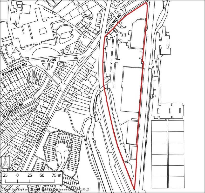
and model market, should establish a new southern anchor to encourage visitors into
the heart of the town centre, and help to support pedestrian movement up the length of
the High Street.
Taller building elements may be appropriate at the northern end of the site, and to the
west along Molesworth Street.
The eastern boundary of the St Stephen’s Conservation Area runs along Lewisham
High Street, opposite the northern portion of the site. Proposals will need to consider
impacts on the significance of this heritage asset and its setting, including the impact on
views from within the Conservation Area.
The site is located within an Archaeological Priority Area, and an archaeological
assessment will be required in line with other Local Plan policies.
Development should positively respond to the town centre’s natural features, including
green spaces and the water environment. Proposals should investigate opportunities to
enhance access to green and water spaces, or enhance visual amenity through
Sustainable Drainage Systems and urban greening.
The site is located within an Archaeological Priority Area, and an archaeological
assessment will be required in line with other Local Plan policies.
8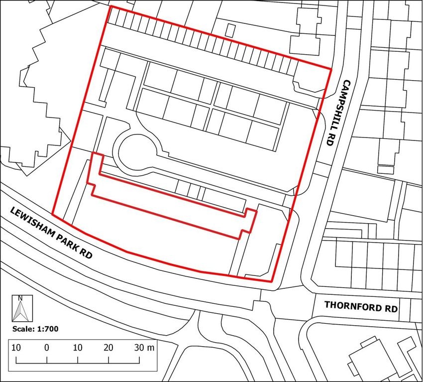
Lewis Grove

Site address:   Lewis Grove, Lewisham, London, SE13
Site details:   Site size (ha): 0.30, Setting: Central, PTAL: In 2015: 6b, In 2021: 6b, In 2031: 6b,
                Ownership: Private, Current use: Main town centre uses, Retail
How site was    Strategic Planning Team
identified:
Planning        Opportunity Area, Secondary frontage within Lewisham major centre, Area of
designations    Archaeological Priority, Critical Drainage Area, Flood Zone 2
and site
constraints:
Planning        None
Status:
Timeframe for   2020/21 – 2024/25     2025/26 – 2029/30     2030/31 – 2034/35      2035/36 – 3039/40
delivery:
Indicative              Net residential units:                   Non-residential floorspace:
development                      73                                  Town centre: 2,363
capacity:                                                             Employment: 394

                                                 9
Site allocation
Mixed-use redevelopment comprising compatible main town centre and residential uses.
Public realm improvements to enhance Lewisham market.
Opportunities
This peninsula site is located at the heart of Lewisham major town centre, with the western
side forming the edge to Lewisham Market and Market Square, the town centre’s most
important public spaces. The site is heavily constrained by the road network and its
occupiers are adversely impacted by the presence of a high volume of traffic, particularly bus
traffic. Comprehensive redevelopment can support the long-term vitality and viability of the
town centre by enabling public realm improvements, particularly to enhance the amenity and
functional qualities of the market area.
Development requirements
The site must be re-integrated with the surrounding street network to improve access
and permeability into and through the town centre. Careful consideration will need to be
given to the access and servicing requirements of the Lewisham Market.
Transport for London must be consulted to ensure development supports the
operational requirements for transport, particularly bus lanes running to the east and
north of the site.
Delivery of new and improved public realm in accordance with a site-wide public realm
strategy, including:
o Enhancements to Lewisham Market, Market Square and the High Street.
Active frontages with appropriate main town centre uses on the ground floors of
buildings.
Conserve or enhance heritage assets and their setting, including: The Clocktower,
Lewisham High Street (Grade II).
Development guidelines
The site’s interface with the Market and Market Square should be the principal
consideration in the design-led approach.
Local amenity is presently adversely affected by the high volume of bus traffic in the
area moving along narrow roads, with particularly narrow pavements abutting the Lewis
Grove. Without improvements to the public realm and/or moving bus traffic, the eastern
building line may have to move back to create a more functional public realm.
Efforts should be made to generate activity and interest along all elevations of the site.
However, the compromised nature of Lewis Grove may mean that market and other
servicing, retail/commercial units and primary residential entrances should be
concentrated along the western edge.
Proposals should investigate opportunities to introduce a new east-west link through the
site to improve site permeability and accessibility in the town centre.
The scale of development should respond to the scale of the historic High Street. Taking
into account potential impact on heritage assets, amenity (including overshadowing) and
the relatively narrow width of Lewis Grove, the site could accommodate buildings that
10exceed the existing prevailing heights, reflecting the site’s urban setting. The tallest
elements should be located towards the southern end of the site.
The Grade II Listed Clocktower should remain discernible and continue to function as a
significant landmark and way finding feature.
The site is located within an Archaeological Priority Area, and an archaeological
assessment will be required in line with other Local Plan policies.
The site features several buildings of architectural merit which should be retained.
11Land at Engate Street
Site address: Engate Street, Lewisham, London, SE13 7HA
Site details: Site size (ha): 0.81, Setting: Central, PTAL: In 2015: 6b, In 2021: 6b, In 2031: 6b,
Ownership: Mixed public and private, Current use: Main town centre uses, Retail,
Employment
How site was London SHLAA 2017
identified:
Planning Opportunity Area, secondary frontage within Lewisham major centre, Area of
designations Archaeological Priority, Critical Drainage Area, Flood Zones 2 and 3, adjacent to
and site Metropolitan Open Land, adjacent to Site of Importance for Nature Conservation
constraints:
Planning None
Status:
Timeframe for 2020/21 – 2024/25 2025/26 – 2029/30 2030/31 – 2034/35 2035/36 – 3039/40
delivery: Yes
Indicative Net residential units: Non-residential floorspace:
development 206 Employment centre: 4,125
capacity: Other: 2,063
12Site allocation
Mixed-use redevelopment comprising compatible main town centre, commercial and
residential uses. Public realm improvements to enhance the environmental quality of the
River Ravensbourne and public access to Waterlink Way.
Opportunities
This site occupies an important transitional position leading into the heart of Lewisham major
town centre from the south, with frontages along the western side of the High Street.
Comprehensive redevelopment and site intensification can deliver a more optimal use of
land to support the long-term vitality and viability of the town centre, along with enhancing
employment provision on site. Redevelopment can also enable public realm and access
improvements, particularly around the River Ravensbourne, better connecting the site to its
immediate surrounds and enhancing its function as a gateway to the heart of the town
centre.
Development requirements
Maintain and enhance the continuity of active frontages along Lewisham High Street,
with appropriate main town centre uses on the ground floors of buildings.
Development will be required to retain or re-provide the existing employment floorspace,
currently situated to the west of Engate Street, and must not result in a net loss of
employment floorspace.
Development must be designed to enhance the ecological quality and amenity provided
by the River Ravensbourne, including by improving public access to Waterlink Way.
Conserve or enhance heritage assets and their setting, including: locally listed buildings.
Development guidelines
The bulk, massing and scale of development must respond to the site’s position relative
to the wider town centre area. The site should function as a transitional zone into the
centre with moderately scaled development, stepping up from Lewisham High Street
and ensuring protection of amenity of neighbouring occupiers and habitats.
Proposals should respond positively to the River Ravensbourne and be designed to
enhance its ecological quality and visual amenity. Site redevelopment presents an
opportunity to improve legibility and access to Waterlink Way at the northern part of the
site.
Proposals should investigate opportunities to introduce a new east-west link through the
site linking the High Street to the River Ravensbourne to improve site permeability and
accessibility to Waterlink Way.
Proposals should be designed having regard to Site C01 (Lewisham Shopping Centre)
particularly to ensure continuity of the High Street and a coordinated approach to public
realm and access.
Development should maximise employment floorspace provision, including through
reconfiguration of buildings and space, and improve the overall environmental quality of
the site. Proposals will be required to justify any net loss of the existing non-designated
floorspace located to the west of Engate Street.
13 The site is located within an Archaeological Priority Area, and an archaeological
assessment will be required in line with other Local Plan policies.
Conington Road
Site address: 209 Lewisham Road, Lewisham, London, SE13 7PY
Site details: Site size (ha): 0.96, Setting: Central, PTAL: In 2015: 5-6b, In 2021: 5-6b, In 2031:
5-6b, Ownership: Private, Current use: Car park
How site was Lewisham Town Centre Local Plan (2014), Lewisham Call for Site (2018) and
identified: London SHLAA (2017)
Planning Opportunity Area, Area of Archaeological Priority, Critical Drainage Area, Flood Zone
designations
and site
constraints:
Planning Full application DC/18/109184 refused by City Hall in March 2019.
Status:
Timeframe for 2020/21 – 2024/25 2025/26 – 2029/30 2030/31 – 2034/35 2035/36 – 3039/40
delivery:
14Indicative Net residential units: Non-residential floorspace:
development 367 Town centre: 3,024
capacity: Employment:1,512
Site allocation
Comprehensive mixed-use redevelopment with compatible main town centre, commercial
and residential uses. Public realm and environmental enhancements including new public
open space, improved pedestrian and cycle routes, and river restoration.
Opportunities
This site occupies an important transitional position from the surrounding residential area
leading into the heart of Lewisham major town centre from the north, and is situated adjacent
to the Lewisham interchange. The River Ravensbourne runs along and through the site. The
site is currently dominated by a fragmented series of surface level car parks. Comprehensive
redevelopment and site intensification, along with the introduction of a wider range of uses,
can deliver a more optimal use of land to support the long-term vitality and viability of the
town centre. Redevelopment can also enable public realm and access improvements, better
connecting the site to its immediate surrounds as well as enhancing access to the
interchange. Development can also facilitate river restoration works.
Development requirements
To reinforce and enhance Lewisham’s role as the principal town centre in the Borough,
and to secure its future status as a Metropolitan Centre of sub-regional significance,
development must provide a mix of new housing, main town centre, commercial and
other complementary uses.
The site must be re-integrated with the surrounding street network to improve access
and permeability into and through the town centre, along with enhancing connections to
the residential areas and public spaces. This will require a clearly articulated network of
east-west and north-south corridors, centred on an improved Silk Mills Path.
Development must deliver high quality public realm with direct links to the Lewisham
interchange.
Active frontages with appropriate main town centre uses on the ground floors of
buildings along key routes.
Delivery of new and improved public realm and open space in accordance with a site-
wide public realm strategy, including:
o A new public square linked to Silk Mills Path;
o A new public square adjacent to Lewisham Stations northern entrance;
o River restoration and a riverside walk.
Development must be designed to improve to the ecological quality of the river
environment and ensure the river corridor is enhanced to form a riverside walk,
incorporating the existing bridges with an attractive and robust embankment.
Development guidelines
15 Development should provide for a complementary mix of uses which support but do not
detract from the vitality and viability of Lewisham town centre, particularly the Primary
Shopping Area.
New buildings should provide high quality urban spaces with generous, functional and
formal landscaped areas forming the central part of an improved Silk Mills Path and the
river corridor. Dissecting Silk Mills Path should be access from Lewisham Road and
Conington Road, linking to the river and Lewisham interchange.
Development should positively respond in scale, bulk and massing to the River
Ravensbourne, taking advantage of the natural slope of the site. The river embankment
should be visually and physically accessible from Conington Road and improve access
to Lewisham transport interchange and the Lewisham Gateway site.
Development should be designed having regard to the scale and grain of the existing
historic fabric towards the southern end of the site, at Silk Mills Path and Lewisham
Road.
Car parking provision should be the minimum required, reflecting the high level of public
transport accessibility of the site. Where car parking is required it should be positioned
to be intuitive to visitors, minimising the impact of access and egress to pedestrians and
other road users.
Proposals should also be designed having regard to their relationship with adjoining
sites, including the Land at Conington Road and Lewisham Road (Tesco) site
immediately adjacent to the south and east, and the Silkworks (Adana Building) and
Silvermills (Hester House) developments to the north.
The site is located within an Archaeological Priority Area, and an archaeological
assessment will be required in line with other Local Plan policies.
16Land at Conington Road and Lewisham Road (Tesco)
Site address: Tesco, 209 Lewisham Road, Lewisham, London, SE13 7PY
Site details: Site size (ha): 1.53, Setting: Central, PTAL: In 2015: 5-6b, In 2021: 5-6b, In 2031:
5-6b, Ownership: Private, Current use: Main town centre uses, Retail, Car park
How site was Lewisham Town Centre Local Plan (2014), Lewisham Call for Site (2018) and
identified: London SHLAA (2017)
Planning Opportunity Area, Area of Archaeological Priority, Critical Drainage Area, Flood Zone
designations
and site
constraints:
Planning None
Status:
Timeframe for 2020/21 – 2024/25 2025/26 – 2029/30 2030/31 – 2034/35 2035/36 – 3039/40
delivery:
Indicative Net residential units: Non-residential floorspace:
development 516 Town centre: 4,820
capacity: Employment: 2,410
17Other: 4,820
Site allocation
Comprehensive mixed-use redevelopment with compatible main town centre, commercial
and residential uses. Public realm and environmental enhancements including new public
open space, improved pedestrian and cycle routes, and river restoration.
Opportunities
This site occupies an important transitional position from the surrounding residential area
leading into the heart of Lewisham major town centre from the north. The River
Ravensbourne runs along its western edge. The site is currently occupied by a large format
retail building and surface level car park. Comprehensive redevelopment and site
intensification, along with the introduction of a wider range of uses, can deliver a more
optimal use of land to support the long-term vitality and viability of the town centre.
Redevelopment can also enable public realm and access improvements, better connecting
the site to its immediate surrounds as well as enhancing access to the interchange.
Development can also facilitate river restoration works.
Development requirements
To reinforce and enhance Lewisham’s role as the principal town centre in the Borough,
and to secure its future status as a Metropolitan Centre of sub-regional significance,
development must provide a mix of new housing, main town centre, commercial and
other complementary uses.
The site must be re-integrated with the surrounding street network to improve access
and permeability into and through the town centre, along with enhancing connections to
residential areas and public spaces. This will require a clearly articulated network of
east-west and north-south corridors, centred on an improved Silk Mills Path.
Active frontages with appropriate main town centre uses on the ground floors of
buildings along key routes.
Delivery of new and improved public realm in accordance with a site-wide public realm
strategy, including:
o A new public square linked to Silk Mills Path;
o River restoration and a riverside walk
Development must be designed to improve to the ecological quality of the river
environment and ensure the river corridor is enhanced to form a riverside walk,
incorporating the existing bridges with an attractive and robust embankment.
Development guidelines
Development should provide for a complementary mix of uses which support but do not
detract from the vitality and viability of Lewisham town centre, particularly the Primary
Shopping Area.
The site should function as a transitional site, both in terms of land use and visual
amenity, from the surrounding neighbourhoods into the transport interchange, Lewisham
Gateway and the heart of the town centre. The scale, bulk and massing of development
must positively respond to the moderately scaled, residential surroundings at the site’s
eastern side, at Conington Road and beyond.
18 New buildings should provide high quality urban spaces with generous, functional and
formal landscaped areas forming the central part of an improved Silk Mills Path and the
river corridor. Dissecting Silk Mills Path should be access from Lewisham Road and
Conington Road, linking to the river and Lewisham interchange.
Development should positively respond in scale, bulk and massing to the River
Ravensbourne, taking advantage of the natural slope of the site. The river embankment
should be visually and physically accessible from Conington Road and improve access
to Lewisham transport interchange, Lewisham Gateway and the wider town centre
environs.
Development should be designed having regard to the scale and grain of the existing
historic fabric towards the southern end of the site, at Silk Mills Path and Lewisham
Road.
Car parking provision should be the minimum required, reflecting the high level of public
transport accessibility of the site. Where car parking is required it should be positioned
to be intuitive to visitors, minimising the impact of access and egress to pedestrians and
other road users.
Proposals should also be designed having regard to their relationship with adjoining
sites, including the Conington Road site immediately adjacent to the north and west.
Development should positively respond to Eagle House, which sits on the site’s eastern
edge fronting Lewisham Road. This building was constructed in approximately 1870 and
is one of the original Anchor Brewery Buildings. It is of architectural and local
significance.
Development should positively resond to the group of buildings located outside of the
sites’s southern boundary, which have particular townscape merit.
The site is located within an Archaeological Priority Area, and an archaeological
assessment will be required in line with other Local Plan policies.
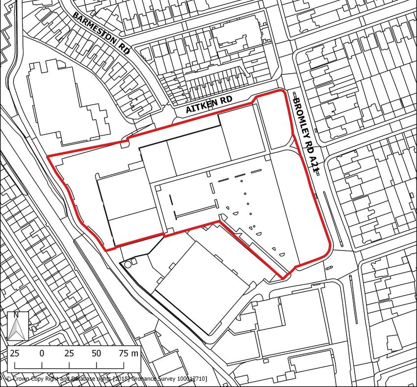
19Molesworth Street Car Park
Site address: Molesworth Street Car Park, Lewisham, London, SE13 7DS
Site details: Site size (ha): 0.49, Setting: Central, PTAL: In 2015: 5-6a, In 2021: 5-6a, In 2031:
5-6a, Ownership: Public, Current use: Car park
How site was Strategic Planning Team
identified:
Planning Opportunity Area, Locally Significant Industrial Site, Area of Archaeological Priority,
designations
and site
constraints:
Planning None
Status:
Timeframe for 2020/21 – 2024/25 2025/26 – 2029/30 2030/31 – 2034/35 2035/36 – 3039/40
delivery:
20Indicative Net residential units: Non-residential floorspace:
development 54 Employment: 1,871
capacity:
Site allocation
Redevelopment for commercial uses.
Opportunities
The site is located within Lewisham major town centre and forms part of a Locally Significant
Industrial Site, the majority of which is occupied by an operational multi-storey data centre.
The site forms the residual land within the LSIS and is currently in use as a car park.
Redevelopment of the site, and the introduction of new workspace, can deliver a more
optimal use of land to support the long-term vitality and viability of the town centre.
Development requirements
Development must not compromise the functional integrity of the employment location,
in line with Policy EC 5 (Locally Significant Industrial Sites).
The nature of commercial uses must be compatible with and not harm the amenity of
the residential uses adjacent to the site.
Development should provide a positive frontage at the site’s eastern edge, along
Molesworth Street.
Development guidelines
Development should maximise employment floorspace provision, giving consideration to
opportunities for multi-storey buildings.
The bulk, massing and scale of development should positively respond to the existing
residential area to the west of the site.
The site is located within an Archaeological Priority Area, and an archaeological
assessment will be required in line with other Local Plan policies.
The site’s location within the town centre and adjacent to the Lewisham Shopping
Centre will necessitate commercial uses are compatible with these neighbouring uses,
and do not adversely impact on amenity. Industrial uses should be avoided.
21Lewisham Retail Park, Loampit Vale
Site address: Lewisham Retail Park and Nos. 66-76 Loampit Vale, Lewisham, SE13
Site details: Site size (ha): 1.04, Setting: Central, PTAL: In 2015: 6b, In 2021: 6b, In 2031: 6b,
Ownership: Private, Current use: Main town centre uses, Retail
How site was Lewisham Town Centre Local Plan (2014) and London SHLAA (2017)
identified:
Planning Opportunity Area, Critical Drainage Area, Flood Zones 1 and 2
designations
and site
constraints:
Planning Full application DC/16/097629 granted in March 2019.
Status:
Timeframe for 2020/21 – 2024/25 2025/26 – 2029/30 2030/31 – 2034/35 2035/36 – 3
delivery: 3,337
039/40
22Indicative Net residential units: Non-residential floorspace:
development 607 Town centre: 3,337
capacity: Employment: 834
Existing planning consent
DC/16/097629 - Comprehensive redevelopment of the Lewisham Retail Park and Nos. 66 –
76 Loampit Vale including the demolition of all buildings on site to facilitate the provision of
4,343sqm of non-residential floorspace comprising (A1) Shops, (A2) Financial &
Professional Services, (A3) Restaurants & Cafés, (B1) Business, (D1) Non-Residential
Institutions and (D2) Assembly & Leisure uses and 536 residential units in buildings ranging
from 4 – 24 storeys in height with private and communal open spaces, on-site energy centre,
car and cycle parking, and associated landscaping and public realm works.
Site allocation
Comprehensive mixed-use redevelopment with compatible main town centre, commercial
and residential uses. Public realm enhancements to deliver a boulevard along Loampit Vale,
with improved pedestrian and cycle routes connecting to Lewisham interchange.
Opportunities
The site is located within Lewisham major town centre and is situated on Loampit Vale, a
main approach to the town centre from the west. The site is currently occupied by a
warehouse with large format retail units and a surface level car park, along with a small
terrace of properties. Comprehensive redevelopment and site intensification, along with the
introduction of a wider range of uses, can deliver a more optimal use of land to support the
long-term vitality and viability of the town centre. Redevelopment can also enable public
realm and access improvements, better connecting the site to its immediate surrounds as
well as enhancing access to Lewisham interchange.
Development requirements
To reinforce and enhance Lewisham’s role as the principal town centre in the Borough,
and to secure its future status as a Metropolitan Centre of sub-regional significance,
development must provide a mix of new housing, main town centre, commercial and
other complementary uses.
Development must not prejudice the future delivery of strategic transport infrastructure,
including infrastructure necessary to facilitate the Bakerloo Line extension.
The site must be re-integrated with the surrounding street network to improve access
and permeability into and through the town centre, along with enhancing connections to
Lewisham interchange. This will require a clearly articulated network of east-west and
north-south corridors, including the creation of active boulevards along Loampit Vale,
Jerrard Street and Thurston Road.
Development must not prejudice the future delivery of transport infrastructure, including
infrastructure necessary to facilitate the Bakerloo Line extension.
Active frontages with appropriate main town centre uses on the ground floors of
buildings along key routes.
Delivery of new and improved public realm in accordance with a site-wide public realm
strategy.
23Development guidelines
Buildings must be of an appropriate scale, responding to the immediate context and
importance of Loampit Vale as a major route and without competing with Lewisham
Gateway.
Development should set out and reinforce a clear hierarchy of streets and building
heights, both within the site and in response to the wider town centre area. A landmark
or way finding building signalling the entrance to Lewisham town centre from Loampit
Vale to the west may be acceptable.
Tree lined pavements of a generous width, indicatively a minimum 6 metres, should
define boulevards at Loampit Vale and Thurston Road with buildings set back at an
appropriate distance.
Proposals should be designed having regard to the Carpetright site, particularly to
ensure continuity of the boulevards along Loampit Vale and Thurston Road, and a
coordinated approach to public realm and access. This includes provision of a new
‘station square’ to create a coherent public space and visual link between the sites.
Transport for London proposals for the extension of the Bakerloo Line through
Lewisham town centre could have an impact on the redevelopment potential of both the
Lewisham Retail Park and Carpetright sites. This is as a result of new tunnels running
underneath and the possibility of a new ‘station box’ being located partly on the bus
layover site (to the north of the Carpetright site), and across a portion of the northern
part of the Carpetright site. The bus layover site has been identified as the preferred
location for the proposed extension.
Building lines may need to be set back to accommodate a dedicated bus lane for turning
from Loampit Vale into Jerrard Street and the resultant depth of pavement.
Consideration should be given to the proximity of the proposed ‘bus layover’ site (part of
the Lewisham Gateway development) when planning for sensitive uses on adjacent
sites.
Support decentralised energy network development.
24Land at Loampit Vale and Thurston Road (Carpetright)
Site address: Carpetright Site, Loampit Vale, Lewisham, SE13 7SN
Site details: Site size (ha): 0.28, Setting: Central, PTAL: In 2015: 6b, In 2021: 6b, In 2031: 6b,
Ownership: Private, Current use: Main town centre uses, Retail
How site was Lewisham Town Centre Local Plan (2014) and London SHLAA (2017)
identified:
Planning Opportunity Area, Critical Drainage Area, Flood Zones 1 and 2
designations
and site
constraints:
Planning Full application DC/17/102049 granted in February 2018
Status:
Timeframe for 2020/21 – 2024/25 2025/26 – 2029/30 2030/31 – 2034/35 2035/36 – 3039/40
delivery:
Indicative Net residential units: Non-residential floorspace:
development 242 Town Centre: 960
capacity:
25Existing planning consent
DC/17/102049 – Comprehensive redevelopment of the Carpetright site, Loampit Vale, includ-
ing the demolition of the existing Carpetright building and the construction of two buildings of
16 storeys and 30 storeys in height comprising 960sq.m non-residential floorspace compris-
ing (A1) Shops, (A2) Financial & Professional Services, (A3) Restaurants & Cafes, (B1)
Business, (D1) Non-residential Institutions and (D2) Assembly & Leisure uses and 242 resi-
dential units with private and communal open space, on-site energy centre, cycle parking
and associated landscaping and public realm works.
Site allocation
Comprehensive mixed-use redevelopment with compatible main town centre, commercial
and residential uses. Public realm enhancements to deliver a boulevard along Loampit Vale,
with improved pedestrian and cycle routes connecting to Lewisham interchange.
Opportunities
The site is located within Lewisham Major Town Centre and is situated on Loampit Vale, a
main approach to the town centre from the west. The site is currently occupied by a
warehouse with a large format retail unit and a surface level car park. Comprehensive
redevelopment and site intensification, along with the introduction of a wider range of uses,
can deliver a more optimal use of land to support the long-term vitality and viability of the
town centre. Redevelopment can also enable public realm and access improvements, better
connecting the site to its immediate surrounds as well as enhancing access to Lewisham
interchange.
Development requirements
To reinforce and enhance Lewisham’s role as the principal town centre in the Borough,
and to secure its future status as a Metropolitan Centre of sub-regional significance,
development must provide a mix of new housing, main town centre, commercial and
other complementary uses.
Development must not prejudice the future delivery of strategic transport infrastructure,
including infrastructure necessary to facilitate the Bakerloo Line extension.
The site must be re-integrated with the surrounding street network to improve access
and permeability into and through the town centre, along with enhancing connections to
Lewisham interchange. This will require a clearly articulated network of east-west and
north-south corridors, including the creation of active boulevards along Loampit Vale
and Thurston Road.
Development must not prejudice the future delivery of transport infrastructure, including
infrastructure necessary to facilitate the Bakerloo Line extension.
Active frontages with appropriate main town centre uses on the ground floors of
buildings along key routes.
Delivery of new and improved public realm in accordance with a site-wide public realm
strategy.
Development guidelines
26 Buildings must be of an appropriate scale, responding to the immediate context and
importance of Loampit Vale as a major route and without competing with Lewisham
Gateway.
Development should set out and reinforce a clear hierarchy of streets and building
heights, both within the site and in response to the wider town centre area.
Tree lined pavements of a generous width, indicatively a minimum 6 metres, should
define boulevards at Loampit Vale and Thurston Road with buildings set back at an
appropriate distance.
Proposals should be designed having regard to the Lewisham Retail Park site,
particularly to ensure continuity of the boulevards along Loampit Vale and Thurston
Road, and a coordinated approach to public realm and access. This includes provision
of a new ‘station square’ to create a coherent public space and visual link between the
sites.
Transport for London proposals for the extension of the Bakerloo Line through
Lewisham town centre could have an effect upon the redevelopment potential of both
the Lewisham Retail Park and Carpetright sites. This is as a result of new tunnels
running underneath and the possibility of a new ‘station box’ being located partly on the
bus layover site (to the north of the Carpetright site), and across a portion of the
northern part of the Carpetright site. The bus layover site has been identified as the
preferred location for the proposed extension.
Building lines may need to be set back to accommodate a dedicated bus lane for turning
from Loampit Vale into Jerrard Street and the resultant depth of pavement.
Consideration should be given to the proximity of the proposed ‘bus layover’ site (part of
the Lewisham Gateway development) when planning for sensitive uses on adjacent
sites.
Support decentralised energy network development.
27Silver Road and Axion House
Site address: Axion House, 1 Silver Road, London, SE13 7BQ
Site details: Site size (ha): 0.48, Setting: Central, PTAL: In 2015: 1b, In 2021: 1b, In 2031: 1b,
Ownership: Private, Current use: Industrial, Vacant land
How site was London SHLAA (2017)
identified:
Planning Opportunity Area, Area of Archaeological Priority, Critical Drainage Area, Flood Zone
designations
and site
constraints:
Planning Application submitted
Status:
Timeframe for 2020/21 – 2024/25 2025/26 – 2029/30 2030/31 – 2034/35 2035/36 – 3039/40
delivery:
Indicative Net residential units: Non-residential floorspace:
development 136 Employment: 718
capacity:
28Site allocation
Employment-led mixed-use redevelopment comprising compatible commercial and
residential uses. Public realm enhancements to improve the amenity provided by the River
the River Ravensbourne.
Opportunities
The site is located within Lewisham Major Town Centre and situated next to the River
Ravensbourne. Redevelopment and site intensification, along with the introduction of a wider
range of uses, can deliver a more optimal use of land to support the long-term vitality and
viability of the town centre, including through provision of modern workspace.
Redevelopment can also enable new high quality development, along with public realm
improvements, that enhance the amenity provided by the River Ravensbourne and better
complement the site’s surrounding residential area.
Development requirements
Development must ensure that current amount of employment floorspace is retained
and re-purposed or re-provided.
Development must be designed to enhance public access to the River Ravensbourne
and improve the amenity provided by it. This includes the integration of new and
enhanced public realm and landscaping alongside the river.
Development guidelines
Proposals should respond positively to the River Ravensbourne and be designed to
enhance its visual amenity.
Development should maximise employment floorspace provision, including through
reconfiguration of the existing building and space, and improve the overall
environmental quality of the site. Proposals will be required to justify any net loss of the
existing non-designated floorspace.
An element of affordable workspace should be delivered on-site.
The bulk, massing and scale of development should respond positively to the residential
properties surrounding the site.
The site is located within an Archaeological Priority Area, and an archaeological
assessment will be required in line with other Local Plan policies.
29PLACE/Ladywell (Former Ladywell Leisure Centre)
Site address: Former Ladywell Leisure Centre, 261 Lewisham High Street, SE13 6NJ
Site details: Site size (ha): 0.93, Setting: Central, PTAL: In 2015: 6a, In 2021: 6a, In 2031: 6a,
Ownership: Public, Current use: Residential, Retail, Employment, Community use
How site was Lewisham Town Centre Local Plan (2014) and London SHLAA (2017)
identified:
Planning Opportunity Area, adjacent to Conservation Area, Area of Archaeological
designations Priority,adjacent to Site of Importance for Nature Conservation
and site
constraints:
Planning Full application DC/15/090792 granted in February 2015 for part of the site.
Status: Development complete but only has temporary consent for four years.
Timeframe for 2020/21 – 2024/25 2025/26 – 2029/30 2030/31 – 2034/35 2035/36 – 3039/40
delivery:
Indicative Net residential units: Non-residential floorspace:
development 274 Town centre: 2,451
capacity: Employment: 1,225
30Existing planning consent
DC/15/090792 – The construction of a four-storey building at the former Ladywell Leisure
Centre, 261 Lewisham High Street SE13, comprising 24 x 2 bed-flats on upper floors (Class
C3), up to 8 x commercial units on the ground floor for flexible use as retail (Class A1),
services (Class A2), business (Class B1) and/or Class D1 non-residential community uses
(Class D1), associated soft and hard landscaping boundary treatments, cycle parking and
bin store, for a limited period of up to 4 years.
Site allocation
Comprehensive mixed-use redevelopment comprising compatible main town centre,
commercial, community and residential uses.
Opportunities
The site is located within Lewisham major town centre and comprises the former Ladywell
Leisure Centre and the land adjoining it. Part of the site fronting the High Street has been
occupied by a meanwhile use, known as PLACE/Ladywell, consisting of a modular building
integrating housing and workspace. This building is to be demounted and re-located
elsewhere in the Borough. Redevelopment and site intensification, along with the
introduction of a wider range of uses, can deliver a more optimal use of land to support the
long-term vitality and viability of the town centre. Development can also help to reinvigorate
the High Street with active frontages and improve connections with the surrounding
residential area.
Development requirements
Development will be required to incorporate positive and active frontages along
Lewisham High Street, with appropriate main town centre uses on the ground floor of
buildings along key routes.
Proposals involving the redevelopment of the Lewisham Opportunity Pre-School (LOPS)
building may be acceptable, subject to appropriate re-provision of community
infrastructure within the locality, in line with Policy CI19 (Safeguarding and securing
community infrastructure).
The layout and design of development must positively respond to the housing estate
immediately adjacent the site to the east, as well as the surrounding residential area.
Development should support the delivery of a cohesive urban form and grain, with
establish a well-integrated and cohesive urban form, along with a clearly articulated
network of routes across the site to improve permeability.
Delivery of new and improved public realm in accordance with a site-wide public realm
strategy, including:
o Public realm enhancements along the High Street
Development guidelines
Development should set out and reinforce a clear hierarchy of streets and building
heights, both within the site and in response to the adjacent network of residential
streets.
Residential ground floor frontages may be acceptable away from the High Street
including at Longbridge Way.
31 The site is adjacent to St Mary’s Conservation Area. Proposals will need to consider
impacts on the significance of this heritage asset and its setting, including the impact on
views from within the Conservation Area.
Historic spires are in view of the St Mary’s Church.
The site is located within an Archaeological Priority Area, and an archaeological
assessment will be required in line with other Local Plan policies.
32Ladywell Play Tower
Site address: Former swimming pool, Ladywell Road, Lewisham, SE13 7UW
Site details: Site size (ha): 0.32, Setting: Central, PTAL: In 2015: 5, In 2021: 5, In 2031: 5,
Ownership: Private, Current use: Former swimming pool, Vacant land
How site was Strategic Planning Team / Pre-application
identified:
Planning , Conservation Area, Listed Building, Area of Archaeological Priority, Critical
designations Drainage Area, Flood Zones 2 and 3
and site
constraints:
Planning Pre-application
Status:
Timeframe for 2020/21 – 2024/25 2025/26 – 2029/30 2030/31 – 2034/35 2035/36 – 3039/40
delivery:
Indicative Net residential units: Non-residential floorspace:
development 33
capacity: Town Centre:1,915
33You can also read