Proposed Amendment No 1 Ballincollig-Carrigaline Municipal District Local Area Plan 2017 ( Cork City Council) - DRAFT Strategic Flood Risk ...
←
→
Page content transcription
If your browser does not render page correctly, please read the page content below
Proposed Amendment No 1         Flood Risk Assessment

Proposed Amendment No 1 Ballincollig-
Carrigaline Municipal District Local Area
Plan 2017 ( Cork City Council)

DRAFT Strategic Flood Risk Assessment

November 2020

Cork City Council
Cork City Council
Flood Risk Assessment                                            Proposed Amendment No 1.

Contents

Section 1 Introduction
1.1 Scope                                                                     1
1.2 Report Structure                                                   1
1.3 The Planning System and Flood Risk                                        1
1.4 Definition of Flood Risk                                           2

Section 2      Local Study Area
2.1         Introduction: The Ballincollig - Carrigaline Municipal District   4
2.2         Population and Household Growth                                          5
2.3         Environment and Heritage                                          5
2.4         Infrastructure                                                           6

Section 3 Flood Risk in the Ballincollig - Carrigaline Electoral Area
3.1 Sources of Flooding                                                       7
3.2 Fluvial Flooding                                               7
3.3 Other Sources of Flooding                                                 9

Section 4 Addressing Flood Risk in the Ballincollig-Carrigaline LAP
4.1 Introduction                                                              11
4.2 Collation of Flood Risk Data                                              11
4.3 Flood Risk within the Municipal District                     12
4.4 Flood Risk Management Strategy                                            16
4.5 Approach to Zoning in Areas at Risk of Flooding                           16
4.6 Approach to Development in Areas at Risk        of Flooding               29
4.7 Flood Risk in Development Management                                      31

Section 5 Flood Risk in the Future
5.1 What has the LAP Achieved                                                 33
5.2 Monitoring and Review                                              33

Cork County Council
Planning Policy Unit
Proposed Amendment No 1                                                    Flood Risk Assessment

Section 1         Introduction

1.1 Scope

1.1.1   This Strategic Flood Risk Assessment of Proposed Amendment No 1 to the
        Ballincollig Carrigaline Municipal District Local Area Plan 2017 has been prepared in
        accordance, in so far as is practicable, with ‘The Planning System and Flood Risk
        Management: Guidelines for Planning Authorities’, published in November 2009 by
        the DEHLG and the OPW, and having specific regard to the areas, within the
        settlements of this Municipal District, that have been identified as being at risk of
        flooding.

1.1.2   This report sets out how the Flood Risk Assessment was undertaken, as well as how
        its findings were addressed and integrated into the Propopesed Amendment The
        report should be read in conjunction with Proposed Amendment No 1 and the
        associated maps.

1.2 Report Structure

1.2.1   Section 2 of this report provides a brief introduction to the former Ballincollig-
        Carrigaline Municipal District, identifying the settlement hierarchy and the key
        population and household growth targets for the respective categories of settlement
        with the settlement hierarchy.

1.2.2   Section 3 examines the main sources of flood risk within the Municipal District and
        recent flood events.

1.2.3   Section 4 examines how the issue of managing flood risk was addressed in the
        Proposed Amendment and outlines the main provisions of the flood risk
        management strategy.

1.2.4   Section 5 sets out what this assessment has achieved in terms of managing the
        adverse effects of flooding within the area of the proposed amendment. It also
        identifies how information on flood risk will be reviewed and monitored consequent
        to the proposed amendment.

1.3 The Planning System and Flood Risk

1.3.1   ‘The Planning System and Flood Risk Management: Guidelines for Planning
        Authorities’, published in November 2009, describe flooding as a natural process
        that can occur at any time and in a wide variety of locations. Flooding can often be
        beneficial and many habitats rely on periodic inundation. However, when flooding
        interacts with human development, it can threaten people, their property and the
        environment. Flooding may be from rivers, the sea, groundwater, sewers or
        overland flow caused by intense or prolonged periods of rainfall. Climate change
        effects suggest that the frequency and severity of flooding is likely to increase in the
        future.

1.3.2   The Guidelines describe good flood risk practice in planning and development
        management and seek to integrate flood risk management into the planning

1                                                                            Cork County Council
                                                                             Planning Policy Unit
process, thereby assisting in the delivery of sustainable development. Planning
Authorities are directed to have regard to the Guidelines in the preparation of
Development Plans and Local Area Plans, and for development management
purposes. For this to be achieved, flood risk must be assessed as early as possible in
the planning process.
1.3.3 Paragraph 1.6 of the Guidelines states that the core objectives are to:
• avoid inappropriate development in areas at risk of flooding;
• avoid new developments increasing flood risk elsewhere, including that which
may arise from surface run-off;
• ensure effective management of residual risks for development permitted in
floodplains;
• avoid unnecessary restriction of national, regional or local economic and social
growth;
• improve the understanding of flood risk among relevant stakeholders; and
• Ensure that the requirements of EU and national law in relation to the natural
environment and nature conservation are complied with at all stages of flood
risk management".
1.3.4 The Guidelines aim to facilitate 'the transparent consideration of flood risk at all
levels of the planning process, ensuring a consistency of approach throughout the
country. The Guidelines work on a number of key principles, including:
• Adopting a staged and hierarchical approach to the assessment of flood risk;
• Adopting a sequential approach to the management of flood risk, based on
the frequency of flooding (identified through Flood Zones) and the
vulnerability of the proposed land use.
1.4 Definition of Flood Risk
1.4.1 Prior to discussing the management of flood risk, it is helpful to understand what is
meant by the term. It is also important to define the components of flood risk in
order to apply the principles of the Guidelines in a consistent manner.
1.4.2 Flood risk is generally accepted to be a combination of the likelihood of flooding and
the potential consequences arising, and is normally expressed in terms of the
following relationship:
Flood risk = Probability of flooding x Consequences of flooding
1.4.3 Likelihood of flooding is normally defined as the percentage probability of a flood of
a given severity occurring in any given year. For example, a 1% probability indicates
the severity of a flood that is expected to be exceeded on average once in 100 years,
i.e. it has a 1 in 100 chance of occurring in any given year.
1.4.4 In the current Local Area Plan, flood risks are defined in relation to the following
zones;
Cork County Council 2
Planning Policy UnitFlood Risk Assessment Proposed Amendment No 1.
• Flood Zone A: where the probability of flooding from rivers and the sea is highest
(greater than 1% or 1 in 100 for river flooding or 0.5% or 1 in 200 for coastal
flooding);
• Flood Zone B: where the probability of flooding from rivers and the sea is moderate
(between 0.1% or 1 in 1000 and 1% or 1 in 100 for river flooding or between 0.1% or
1 in 1000 and 0.5% or 1 in 200 for coastal flooding);
• Elsewhere, sometimes referred to as Zone C, the probability of flooding from rivers
and the sea is low (less than 0.1% or 1 in 1000 for both river and coastal flooding).
This zone covers all areas of the Plan which are not in zones A or B.
1.4.5 Consequences of flooding depend on the hazards caused by flooding (depth of
water, speed of flow, rate of onset, duration, wave-action effects, water quality) and
the vulnerability of receptors (type of development, nature, e.g. age-structure, of
the population, presence and reliability of mitigation measures etc).
1.4.6 The ‘Planning System and Flood Risk Management: Guidelines for Planning
Authorities’, provides three vulnerability categories, based on the type of
development, detailed in Table 3.1 of the Guidelines, and are summarised as:
• Highly vulnerable, including residential properties, essential infrastructure and
emergency service facilities;
• Less vulnerable, such as retail and commercial and local transport
infrastructure
• Water compatible, including open space, outdoor recreation and associated
essential facilities, such as changing rooms.
3
Cork County Council
Planning Policy UnitProposed Amendment No 1 Flood Risk Assessment
Section 2 Local Study Area
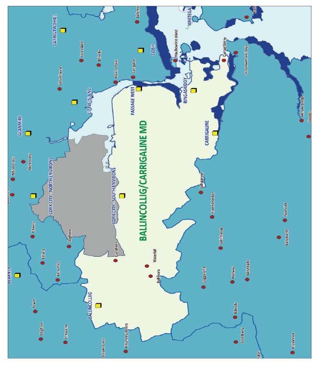
2.1 Introduction: The Ballincollig-Carrigaline Municipal District
2.1.1 The former Ballincollig-Carrigaline Municipal District lies entirely within the County
Metropolitan Strategic Planning area as defined in the County Development Plan
2014. It is a predominantly rural Municipal District that accommodates an extensive
network of settlements as follows:
• Five Main Settlements comprising Ballincollig, Carrigaline, Cork City South
Environs, Passage West and Ringaskiddy.
• Two Villages comprising Ballynora and Waterfall.
• Three Other Locations comprising Curraghabinny, Curraheen and Farmers Cross
Figure 1 Ballincollig Carrigaline Municipal District
Cork County Council 4
Planning Policy UnitFlood Risk Assessment Proposed Amendment No 1.
2.2 Population and Household Growth
2.2.1 Within the Ballincollig-Carrigaline Municipal District the County Development Plan
provides for growth in population of 14,376 persons. The number of households is
expected to grow by 9,847 leading to a net requirement for 9,546 new houses. The
County Development Plan indicates that 347 ha of zoned land are required to meet
this level of housing provision in the main towns, in addition to housing
opportunities in the villages and rural areas.
2.2.2 Almost all of the growth, 9,144 proposed dwellings is allocated to the towns in the
Municipal District, all of which form part of the County Metropolitan Area of Cork
City, a designated Gateway in the National Spatial Strategy, and in line with the
South West Regional Planning Guidelines. Some modest housing growth is also
planned within the villages and other locations within the district (480 units).
2.2.3 Arising from the County Development Plan 2014, Table 2.2 shows that there is a net
requirement within the towns of the Municipal District for 9,144 new dwelling units
and capacity, in terms of the current provision of zoned lands within the towns, to
accommodate 9,509.
Table 2.1: Ballincollig-Carrigaline Municipal District
Housing Requirement Housing Supply
Censu Populatio New Net Estimated Net Estimated Housing
s 2011 n Target Units Estimated Residential area Yield (LAPs and
Required Requirement zoned in LAP / TCPs)
(ha) TCP (ha)
Ballincollig 17,368 23,805 4,033 161 170.3 4,872
Carrigaline
(North & 14,775 17,870 2,422 97 90.80 2,423
South)
Cork City
South 32,635 31,308 1,284 37 93.00 1,285
Environs
Passage West 5,790 6,965 925 51 33.90 929
Main Towns 65,710 74,072 8,663 347 388.0 9,509
Villages 278 355 55 - - 37
Rural 5,958 6,019 425 - - --
Total
Villages and 6,236 6,374 480 37
Rural
Total
Municipal 71,946 86,322 9,144 347 388 9,546
District *
Current Estimated Strategic Land Reserve (LAPs and TCPs) for this Municipal District is 41.3Ha
Source: Cork County Development Plan 2014- Volume One. Appendix B, Table B 8
*including Carrigaline South
5
Cork County Council
Planning Policy UnitBallincollig Carrigaline Municipal District Flood Risk Assessment
2.3 Environment and Heritage –
2.3.1 European and National legislation now protects the most valuable of our remaining
wild places, through designation of sites as proposed Natural Heritage Areas,
candidate Special Areas of Conservation and Special Protection Areas. The current
list of protected sites is contained in the County Development Plan 2014 and is
shown on the Heritage and Scenic Amenity Maps in Volume 3 in that Plan.
Designated sites in the Ballincollig-Carrigaline Municipal District are detailed in the
table below.
Designated Sites in the Ballincollig-CarrigalineMunicipal District
Code Description Natura 2000 Site
pNHA 0094 Lee Valley No
pNHA 1046 Douglas River Estuary No
pNHA 1066 Lough Beg ( Cork) No
pNHA 1979 Monkstown Creek No
pNHA 1990 Owenboy River No
SPA-4030 Cork Harbour Yes
2.3.2 To date, sites of geological interest have not been comprehensively covered by the
existing nature conservation designations. Cork County Council recognises the
importance of geological heritage and to this end has listed the important geological
features within the County, in the County Development Plan 2014, with the
intention of maintaining their possible conservation value. Geological features of
interest in the Ballincollig-Carrigaline Municipal District include; armour stone at
Lough Beg and Curraghbinny, and raised beaches in Cork Harbour.
2.3.3 In terms of built heritage, there are numerous recorded monuments and protected
structures throughout the Municipal District and these are also detailed in the
County Development Plan 2014.
2.4 Infrastructure
Water and Waste Water
2.4.1 There are significant infrastructural deficiencies within the Municipal District in
terms of waste water treatment and water supply services that will need to be
addressed over the lifetime of the Local Area Plan if the growth targets for the
Municipal District are to be achieved, including for example the upgrading of waste
water treatment plant facilities and the implementation of water conservation
measures.
2.4.2 In the South Environs, pumping of stormwater due to combined sewers is an issue in
the area and upgrades to pumping stations in the area may be required to facilitate
development during the lifetime of this plan.
2.4.3 Surface water generally discharges to one of a number of local watercourses that
feed into the Tramore Valley. At times of heavy rainfall, the extent of development
in recent years has sometimes led to floods occurring where flows have exceeded
Cork County Council 6
Planning Policy UnitFlood Risk Assessment Proposed Amendment No 1.
the capacity of this river system. Future development proposals will require detailed
analysis to ensure that the rate and volume of projected surface water discharge is
within the capacity of the receiving system.
2.4.4 A drinking water supply is available to accommodate proposed development in Cork
City South Environs. However the upgrading of high level supplies including
reservoir and watermains is required to provide adequate water pressures to some
high level sites. Extension of water mains is required to provide water supply to
some other sites.
Road Network
2.4.5 The City South Environs is heavily dependent on a road network which suffers from
heavy peak hour congestion. This problem is most acutely felt in Douglas where it is
difficult to make improvements to the local road network given the compact nature
of the existing urban environment. In order to relieve this congestion the local road
network serving the area has to be adapted to accommodate public transport by
enhancing the local road infrastructure serving the area, by facilitating greater public
transport use and by creating a more pedestrian friendly urban setting.
2.4.6 Insert M28
2.4.7 The N40 South Ring Road is a National Primary Route which provides strategic
connectivity between the N22, N71, N27 and N28 with the wider National Route
Network. It also serves a traffic distribution function for the southern periphery of
Cork City. The N40 Road is subject to heavy congestion and resultant delay during
peak periods
2.4.8 In order to protect this regionally important road, a demand study was
commissioned by Transport Infrastructure Ireland (TII). This study will seek to ensure
that capacity along the N40 is protected as demand rises in the future.
2.4.9 Significant road improvements are also needed to service the current and future
traffic volumes in the western portion of the area, along with the provision of
footpaths, public lighting and cycling routes from Togher Village to the residential
developments which have occurred along Matthew Hill and Togher Road over the
last decade.
2.4.10 Ringaskiddy is served by the N-28 National Primary Route which links the settlement
to Cork City and onwards to the wider regional and national road network. It is
proposed to construct a new M28 Motorway from Cork to Ringaskiddy from the
existing N28 N40 Bloomfield interchange on the South Ring Road to Ringaskiddy
village.
7
Cork County Council
Planning Policy UnitProposed Amendment No 1 Flood Risk Assessment
Section 3 Flood Risk in the Ballincollig-Carrigaline Municipal
District
3.1 Sources of Flooding –
3.2.1 This SFRA has primarily reviewed flood risk from fluvial and tidal sources. Flood risks
from pluvial and groundwater sources or from drainage systems, reservoirs and
canals and other artificial or man-made systems have not been considered in detail
in this study and such risks will need to be assessed at the project stage.
3.2.2 This approach has been adopted for two main reasons. Firstly, the review of flooding
in the Ballincollig-Carrigaline Municipal District and in particular the City South
Environs shows rivers to be the most common source of damage and it is this source
of flooding that has been taken into account in the Local Area Plan process. Other
sources of flooding are considered to present a lesser risk in this Municipal District
but should be considered at the planning application stage. Secondly, Flood Zones in
the 'Planning System and Flood Risk Management' are defined on the basis of fluvial,
and where appropriate, tidal flood risk.
3.2 Fluvial Flooding
3.2.3 Flooding of watercourses is associated with the exceedance of channel capacity
during higher flows. The process of flooding on watercourses depends on a number
of characteristics associated with the catchment including; geographical location and
variation in rainfall, steepness of the channel and surrounding floodplain and
infiltration and rate of runoff associated with urban and rural catchments. There are
two main catchment types - large and relatively flat or small and steep, the two
giving two very different responses during large rainfall events.
3.2.4 In a large, relatively flat catchment, flood levels will rise slowly and natural
floodplains may remain flooded for several days, acting as the natural regulator of
the flow. In small, steep catchments, local intense rainfall can result in the rapid
onset of deep and fast-flowing flooding with little warning. Such “flash” flooding,
which may only last a few hours, can cause considerable damage and possible threat
to life.
3.2.5 The form of the floodplain, either natural or urbanised, can influence flooding along
watercourses. The location of buildings and roads can significantly influence flood
depths and velocities by altering flow directions and reducing the volume of storage
within the floodplain. Critical structures such as bridge and culverts can also
significantly reduce capacity creating pinch points within the floodplain. These
structures are also vulnerable to blockage by natural debris within the channel or by
fly tipping and waste.
3.2.6 Rivers are the primary cause of flooding in the Ballincollig Carrigaline Municipal
District with flood events attributed to fluvial sources ranging from the Curraheen
and Tramore Rivers in particular to smaller tributaries and drains.
3.2.7 The City South Environs is most affected by flooding from the River Lee and its
tributaries. The Lee River catchment covers an area of approximately 2,000 square
kilometres. The catchment is defined by the land area drained by the River Lee, its
tributaries and Cork Harbour.
3.2.8 The Lee River can be broken down into nine sub catchments as follows: Upper River
Lee; Lower River Lee; Tramore/Douglas River; Kiln River; Glashaboy River;
Owennacurra River; Carrigtohill area; Owenboy River; and Cork Harbour. The
8 Cork County Council
Planning Policy UnitFlood Risk Assessment Proposed Amendment No 1.
majority of the Ballincollig Carrigaline Municipal District is covered by the sub
catchments of the Lower Lee and the Owenboy. Curaheen and Tramore River
catchments. The Lower Lee system runs between Inniscarra dam and the City
boundary before entering Lough Mahon.
Douglas ( City South Environs) was badly affected by flooding in 2012. As a result Cork
City Council , acting as Agents for the OPW has now commenced works on a Flood
Relief Scheme for Douglas. The scheme involved the replacement of the existing
under capacity culverts on the Tramore River.
3.3 Other Sources of Flooding
3.3.1 Other sources of flooding including pluvial, ground water, drainage systems and
reservoirs are detailed below. Risks from these sources have not been specifically
considered in the Strategic Flood Risk Assessment undertaken for the Proposed
Amendment and need to be addressed at the planning application stage.
• Pluvial Flooding: Pluvial flooding is a result of rainfall generated overland
flows of water. Flooding of land from surface water runoff is usually
caused by intense rainfall that may only last a few hours. The resulting
water follows natural valley lines, creating flow paths along roads and
through and around developments and ponding in low spots, which often
coincide with fluvial floodplains in low lying areas.
• Groundwater Flooding: Groundwater flooding is caused by the emergence
of water originating from underground, and is particularly common in
karstic landscapes. This can emerge from either point or diffuse locations.
The occurrence of groundwater flooding is usually very local and unlike
flooding from rivers and the sea, does not generally pose a significant risk
to life due to the slow rate at which the water level rises.
• Flooding from Drainage Systems: Flooding from artificial drainage
systems occurs when flow entering a system, such as an urban storm
water drainage system, exceeds its discharge capacity, it becomes blocked
or it cannot discharge due to a high water level in the receiving
watercourse. Sewer flooding problems will often be associated with
regularly occurring storm events during which sewers and associated
infrastructure can become blocked or fail.
• Flooding from Reservoirs, Lakes and other Artificial Sources: Reservoirs
can be a major source of flood risk, as demonstrated in the 2009 flooding,
when waters released from the Inniscarra Dam flooded sections of Cork
City.
9
Cork County Council
Planning Policy UnitBallincollig Carrigaline Municipal District Flood Risk Assessment
Section 4 Addressing Flood Risk in Proposed Amendment No 1 to the
Ballincollig Carrigaline MD Local Area Plan
4.1 Introduction
4.1.1 This section details the approach to Flood Risk Management adopted in the
Proposed Amendment
4.2 Collation of Flood Risk Data
4.2.1 In 2010, as part of the review of its Local Area Plans, and in order to meet the needs
of the Strategic Environmental Assessment process and the requirements of the
Department of the Environment, Heritage and Local Government / Office of Public
Works Guidelines, “The Planning System and Flood Risk Management” (2009), Cork
County Council undertook a county wide Strategic Flood Risk Assessment using data
prepared on its behalf by JBA Consultants. The Council also conferred with OPW
officials, the Lead Agency for Flood Risk Management in Ireland, in completing the
county wide assessment of flood risks and in formulating the flood risk management
strategy which informed the preparation the 2011 Local Area Plans.
4.2.2 For the purposes of the assessment, information about flood risks was collated from
a number of sources including:
• ‘Floodmaps.ie’ – The national flood hazard mapping website operated by the
Office of Public Works, where information about past flood events is recorded
and made available to the public. ‘Flood point’ information available on this
site has not been included for technical reasons.
• ‘Flood Hazard Mapping’ for fluvial and tidal areas commissioned by Cork
County Council from JBA Consulting. These indicative flood extent maps
provided flood extent information for river catchments where a more detailed
CFRAMS study was not available.
• Draft River Lee Catchment Flood Risk Assessment and Management Study (Lee
CFRAMS) data was used for areas within the catchment of the study.
4.2.3 This data was amalgamated into a single ‘Indicative Flood Zone Map’ for the County,
which was then used as the basis for the flood risk assessment of the 2011 Local
Area Plans. The flood zone map showed the areas known to be at risk of fluvial
(river) or tidal flooding only. It should be noted that the flood zones are based on an
undefended scenario and do not take the presence of flood protection structures
such as walls or embankments into account. This is to allow for the fact that there is
still a residual risk of flooding behind the defences due to overtopping or breach,
and that there may be no guarantee that the defences will be maintained in
perpetuity. This is accordance with the requirements of the Guidelines which specify
an undefended assessment of risk.
4.2.4 In 2016, as part of the further review of the Local Area Plans the Council
commissioned an update of the flood zone mapping used in the 2011 to take
account of the information that has become available in the intervening period from
other flood studies, including the outputs from the National CFRAM Programme
(Catchment Flood Risk Assessment and Management), undertaken by the OPW.
4.2.5 The updated flood zone mapping provides information on the three main flood
zones as follows:
Cork County Council 10
Planning Policy UnitFlood Risk Assessment Proposed Amendment No 1.
• Zone A – High probability of flooding. Most areas of the County that are
subject to flood risks fall into this category. Here, most types of development
would be considered inappropriate. Development in this zone should be
avoided and/or only considered in exceptional circumstances, such as in major
urban or town centres, or in the case of essential infrastructure that cannot be
located elsewhere. A Justification Test set out in Ministerial Guidelines applies
to proposals in this zone. Only water-compatible development, such as docks
and marinas, dockside activities that require a waterside location, amenity
open space, outdoor sports and recreation, would be considered appropriate
in this zone.
• Zone B - Moderate probability of flooding. In most parts of the County this
designation applies only to limited areas of land. In only a few locations do
significant sites fall into this category. Here, highly vulnerable development,
such as hospitals, residential care homes, Garda, fire and ambulance stations,
dwelling houses and primary strategic transport and utilities infrastructure,
would generally be considered inappropriate. Less vulnerable development,
such as retail, commercial and industrial uses, sites used for short-let for
caravans and camping and secondary strategic transport and utilities
infrastructure, should only be considered in this zone if adequate sites are not
available in Zone C, and subject to a flood risk assessment demonstrating that
the risk can be appropriately managed”.
• Elsewhere (referred to in the Guidelines as Flood Zone C) – Localised flooding
from sources other than rivers and the coast can still occur and may need to
be taken into account at the planning application stage. l
4.2.6 Extracts from the flood zone map are shown, where relevant, on the settlement
maps included in the Local Area Plan. The maps are indicative in nature and are
intended to primarily function as a screening tool. The areas at risk may be more or
less extensive in practice than indicated in the flood mapping. The mapping may be
refined where possible over time as other more detailed flood risk assessments are
completed by the OPW.
4.2.7 Within areas not specifically identified by the plan as being at risk of fluvial or tidal
flooding (i.e. within Zone C) a flood risk screening assessment may still be required
to assess potential impact of development on adjoining Flood Zones A or B,
particularly with respect to surface water management . An assessment of the risk
of other sources of flooding such as pluvial or ground water flooding may also be
needed.
4.2.8 The inclusion of the flood zone information on the settlement maps of the Municipal
District is the first step in managing flood risk in the future. The updated mapping
provides for an improved understanding of flood risk issues within the County. The
maps indicate the extent of flood zones that should be safeguarded from
development and will support the application of the sequential approach, and the
justification test as appropriate, in areas where development is proposed.
4.2.9 As part of the review of the Local Area Plans, all zoned lands in areas at risk of
flooding have been considered in the context of the updated indicative flood zone
maps.
4.3 Flood Risk within the Ballincollig-CarrigalineMunicipal District
4.3.1 Flood risk to each settlement has been appraised based on the Indicative Flood
Zones which cross the settlement boundary, and is summarised in Table 4.1.
11
Cork County Council
Planning Policy UnitBallincollig Carrigaline Municipal District Flood Risk Assessment
Table 4.1: Flood Risk by Settlement in the Ballincollig-Carrigaline Municipal District
Settlement Indicative Fluvial/ Comment
Coastal Flood Risk
within Development
Boundary
Main Settlements
Ballincollig Yes All development proposals within the
Indicative Flood Zone Areas will need to
Carrigaline Yes comply with the flood risk assessment
procedure detailed in Section 4.6 of this
City South Environs Yes report i.e. verification of Indicative Flood
Zone mapping, compliance with the
requirements of the Development Plan
Justification Test, and detailed site
specific assessment, as appropriate.
4.4 Flood Risk Management Strategy
4.4.1 The assessment and management of flood risks in relation to planned future
development is an important element of sustainable development. The majority of
towns, villages and smaller settlements have a river or stream either running
through the built-up area or close by and are inevitably exposed to some degree of
flood risk when those rivers or streams overflow their normal course. Similarly, in
coastal areas, flooding can periodically occur following unusual weather or tidal
events.
4.4.2 Generally, the purpose of zoning is to indicate to property owners and members of
the public the types of development which the Planning Authority considers most
appropriate in each land use category. Zoning is designed to reduce conflicting uses
within areas, to protect resources and, in association with phasing, to ensure that
land suitable for development is used to the best advantage of the community as a
whole.
4.4.3 The approach adopted has generally been to
• Include, on the settlement maps, information on the areas at risk of flooding
(extent of Flood Zones A and B),
• Avoid development in areas at risk of flooding; and
• Where development in floodplains cannot be avoided, to take a sequential
approach to flood risk management based on avoidance, reduction and
mitigation of risk.
4.4.4 In response to local circumstances, particularly where there may be some
uncertainties in relation to flood risk data or where land has been zoned in a
previous plan or planning permission has already been granted, the approach has
been modified and lands have been zoned for development with a requirement that
Cork County Council 12
Planning Policy UnitFlood Risk Assessment Proposed Amendment No 1.
a detailed site specific flood risk assessment be carried out at the project stage. This
is explained in more detail below.
4.5 The Approach to Zoning in Areas at Risk of Flooding.
4.5.1 Within the areas identified by the Indicative Flood Risk Mapping as being at risk
(Zone A or B), all proposals for development will need to comply with the Ministerial
Guidelines – ‘The Planning System and Flood Risk Management. In this LAP, land use
zoning objectives within the indicative Flood Risk Areas have been included in the
plan where either:
• The land use zoning objective has been considered in the context of the
“Development Plan Justification Test” set out in the Ministerial Guidelines;
• The zoning objective stemmed from a similar objective in a previous Plan and
has been included in this Plan in order to facilitate the local verification of the
indicative Flood Risk Maps at the project planning/planning application stage.
4.5.2 In the preparation of Proposed Amendment No 1 to the Ballincollig-Carrigaline
Municipal District LAP, proposed zonings were generally assessed relative to the
provisions of the Guidelines and the Justification Test for Development Plans as
detailed in the Guidelines. The Justification Test is generally required in situations
where the planning authority needs to consider future development in areas at a
high or moderate risk of flooding, for uses or development vulnerable to flooding
that would otherwise be inappropriate. In such circumstances, all of the following
criteria must be satisfied :
a) The urban settlement is targeted for growth in the NSS, RPGs, or statutory
plans defined under the provisions of the Planning and Development Act,
2000, as amended.
b) the zoning is required to achieve the proper planning and sustainable
development of an urban settlement and is
o Essential to facilitate the regeneration and/or expansion of the centre
of the urban settlement;
o Comprises significant previously developed and/or under-utilised lands;
o Is within or adjoining the core of an established or designated urban
settlement;
o Will be essential to achieving compact and sustainable urban growth;
and
o There are no suitable alternative lands for the particular use in areas at
lower risk of flooding within or adjoining the core of the urban
settlement
c) A flood Risk Assessment to the appropriate level of detail has been carried
out as part of the SEA, which demonstrates that flood risk to the
development can be adequately managed and the development will not
cause adverse impacts elsewhere.
4.4.5 In the preparation of the Draft Ballincollig-CarrigalineMunicipal District Local Areas
Plan the final element of the Justification Test (part (c ) above), which requires a site
specific flood risk assessment to be carried out, was not undertaken. In some cases,
certain zonings were included in areas at risk of flooding, even when such zoning did
not pass the Justification Test, as a response to a desire to retain those zonings
13
Cork County Council
Planning Policy UnitBallincollig Carrigaline Municipal District Flood Risk Assessment
where planning permission had been granted or where the zoning had already been
made in a previous Plan.
4.4.6 Instead, the approach taken in the Draft Local Area Plan provides, in the first
instance, for the detailed assessment of the extent of the actual flood risk relative to
that indicated on the indicative mapping via a phased flood risk assessment
procedure, as detailed in Section 4.6 of this report. The first stage of this
assessment process provides a prospective developer with the opportunity to verify
the Indicative Flood Zone Mapping in the first instance, and address any local
ambiguities. Depending on the outcome of the verification stage, a prospective
developer may then have the opportunity to demonstrate compliance with the
requirements of the Development Plan Justification Test and carry out a detailed site
specific assessment, as appropriate.
4.4.7 Development proposals on lands within areas at risk of flooding will also be subject
to the ‘Development Management Justification Test’, details of which are set out in
the Guidelines.
Note: Proposals for ‘open space or outdoor recreation development have not been
included in Table 4.2 because these are normally water compatible forms of
development and, therefore, do not need to be subjected to the ‘Development
Plan’ Justification Test. However, an appropriate flood risk assessment will be
necessary at the project planning/ planning application stage.
Approach to Development in Areas at Risk of Flooding
4.5.1 Where development is proposed within an area at risk of flooding, either on
land that is subject to a specific zoning objective, lands within the “existing
built up area” of a town or within a development boundary of a village,
there are a number of steps that a applicant for planning permission may
need to complete as follows:
a) Verification of the Indicative Flood Zone Mapping:
b) Compliance with the ‘Development Plan Justification Test’ ;
c) Detailed site specific flood risk assessment.
4.5.2 These steps are set out in more detail in the Table below.
Table Flood Risk Assessment Procedure for Development Proposals Located within
Areas at Risk of Flooding
1 Verification of In order to reflect the possibility that the ‘Indicative Flood
flood zone Zone Maps’ may include some localised uncertainties, all
mapping applicants have the opportunity to carry out their own flood
risk assessment to verify the accuracy of the flood zone
information included within the Local Area Plan.
The extent of the study area to be included in such an
assessment should be agreed in advance with the Planning
Authority. This verification process is intended to be carried
Cork County Council 14
Planning Policy UnitFlood Risk Assessment Proposed Amendment No 1.
Table Flood Risk Assessment Procedure for Development Proposals Located within
Areas at Risk of Flooding
out relatively quickly and at modest expense, but should
include the following:
• An examination of all sources of flooding that
may affect a particular location, in addition to
the fluvial and tidal risk represented in the
indicative flood risk maps. Local knowledge of
flood events may be useful.
• A review of all available flood related
information, including the flood zone maps and
historical flood records (from
www.floodmaps.ie, and through wider internet
/ newspaper / library search/ local knowledge
of flooding in the area).
• An appraisal of the relevance and likely
accuracy / adequacy of the existing
information. For example, if the outline is from
CFRAM or other detailed study they can be
relied on to a greater extent than if they are
from other sources.
• Site cross sections or spot levels, including the
river and surrounding lands.
• Description of the site and surrounding area,
including ground conditions, levels and land
use.
• Commentary on any localised uncertainty in the
existing flood mapping and other sources of
flood risk information and the site area.
• Proposal as to the appropriate course of action
which could be either:
further study in relation to the flood
risk affecting the lands;
revision of development proposals to
avoid areas shown to be at risk of
flooding; or
Continue with development as
proposed (if the site is clearly
demonstrated to be outside Flood
Zones A or B and has been shown not to
be at flood risk, having also had regard
to the provisions of Section 3.3).
It is recommended that prospective applicants for planning
permission should carry out this first stage ‘Verification’
process’ well in advance of the submission of their application
15
Cork County Council
Planning Policy UnitBallincollig Carrigaline Municipal District Flood Risk Assessment
Table Flood Risk Assessment Procedure for Development Proposals Located within
Areas at Risk of Flooding
for planning permission and that its recommendations should
be brought to the attention of Council staff as part of a pre-
planning meeting.
2 Flood Risk Is Where the ‘Verification’ process outlined above indicates that
verified: the land is in fact at risk of flooding then, in accordance with
the “avoid” principle of the Guidelines, there is a
presumption against development, and the sequential
approach should be used to find an alternative site for
development that is not at risk of flooding.
2(a) Development Should the applicant wish to proceed further with the
Plan Justification development proposal, then the applicant needs to be able to
Test. demonstrate, to the satisfaction of the Planning Authority,
that the proposal meets the requirements of the
‘Development Plan Justification Test’ as set out in the
Guidelines and as detailed in section 4.4.3 above. Where the
Council is satisfied that the proposal satisfies the
requirements of the Development Plan Justification Test, it
shall confirm this in writing to the applicant.
If the proposal is considered to meet the requirements of the
Development Plan Justification Test then prospective
developers should proceed to a more detailed site specific
flood risk assessment in line with Chapter 5 of the Guidelines.
Thereafter, where development has to take place in areas at
risk of flooding, the risks should be mitigated and managed
through the location, layout and design of the development
to reduce such risks to an acceptable level.
Prospective applications are asked to advise Cork County
Council of the actual verified flood risk.
2(b) Detailed site Where, following a detailed site specific assessment, it can be
specific satisfactorily shown that the proposed development, and its
Assessment infrastructure, will avoid significant risks of flooding in line
with the principles set out in the Ministerial Guidelines, then,
subject to other relevant proper planning considerations,
permission may be granted for the development.
3 No flood risk Where the ‘Verification’ process outlined above shows
demonstrated. satisfactorily that the site is not at risk of flooding, and the
County Council has agreed in writing with such a conclusion,
then, subject to other normal planning considerations, an
application for planning permission may be favourably
considered.
4.6 Flood Risk and Development Management
Cork County Council 16
Planning Policy UnitFlood Risk Assessment Proposed Amendment No 1.
4.6.1 In addition to the requirements set out in Table regard should also be had to the
following:
a) Minor proposals for development, for example small extensions to existing
houses or changes of use, in areas at moderate to high risk of flooding
should be assessed in accordance with Planning Guidelines: The Planning
System and Flood Risk Management.
b) Where flood risk constitutes a significant environmental effect of a
development proposal, a sub-threshold EIS may be triggered. Screening for
EIA should be an integral part of all planning applications in areas at risk of
flooding.
c) Any proposal in an area at risk of flooding that is considered acceptable in
principle must demonstrate that appropriate mitigation measures can be put
in place and that residual risks can be managed to acceptable levels.
Addressing flood risk in the design of new development should consider the
following:
• Locating development away from areas at risk of flooding, where
possible.
• Substituting more vulnerable land uses with less vulnerable ones.
• Identifying and protecting land required for current and future flood
risk management, such as conveyance routes, flood storage areas and
flood protection schemes etc.
• Addressing the need for effective emergency response planning for
flood events in areas of new development.
d) Site layout, landscape planning and drainage of new development must be
closely integrated to play an effective role in flood-reduction. As such,
proposals should clearly indicate:
• The use of Sustainable Drainage Systems (SuDS) to manage surface
water run-off.
• Water conveyance routes free of barriers such as walls or buildings.
• The signing of floodplain areas to indicate the shared use of the land
and to identify safe access routes.
e) To ensure that adequate measures are put in place to deal with residual
risks, proposals should demonstrate the use of flood-resistant construction
measures that are aimed at preventing water from entering a building and
that mitigate the damage floodwater causes to buildings. Alternatively,
designs for flood resilient construction may be adopted where it can be
demonstrated that entry of floodwater into buildings is preferable to limit
damage caused by floodwater and allow relatively quick recovery. Such
measures include the design and specification of internal building services
and finishes. Further detail on flood resilience and flood resistance are
included in the Technical Appendices of the Planning Guidelines, The
Planning System and Flood Risk Management.
17
Cork County Council
Planning Policy UnitBallincollig Carrigaline Municipal District Flood Risk Assessment
Section 5 Managing Flood Risk in the Future
5.1 What has the LAP Achieved
5.1.1 The inclusion of Indicative Flood Zone maps for the settlements of the Municipal
District is the first step in managing flood risk in the future. The maps are primarily
intended to function as a screening tool. They are not a substitute for detailed
hydraulic modelling, such as may be required to assess the level of flood risk for a
specific development. The flood maps should be used to guide decision making
when determining whether a detailed Flood Risk Assessment is required for any
given site. The maps are intended for guidance, and cannot provide details for
individual properties.
5.2 Monitoring and Review
5.3.1 Information in relation to flood risk will be monitored and reviewed by the Council
and the Flood Risk Assessment will be updated as appropriate as new information
becomes available. There are a number of key outputs from possible future studies
and datasets which could inform any update of the FRA as availability allows. A list of
potential sources of information which will inform an FRA review is provided in the
table below.
Potential Sources of Flood Risk Data
Data Source Timeframe
City Development Plan Review Cork City Council 2021
Flood maps of other sources, such as Various Unknown
canal breach and drainage networks
Significant flood events Various Unknown
Changes to Planning and / or Flood DoEHLG /OPW /Cork City Council Unknown
Management Policy
SFRAs for Development Plan Cork City Council Upon CDP review
Detailed FRAs Various Unknown
Flood Defence Feasibility / Design OPW primarily Unknown
Reports
Cork City Council 18
Proposed Amendment No 1.You can also read