PLANNING SUBMISSION LANDS AT MARSH ROAD, DROGHEDA, CO LOUTH - Louth County Council
←
→
Page content transcription
If your browser does not render page correctly, please read the page content below
PLANNING SUBMISSION LANDS AT MARSH ROAD, DROGHEDA, CO LOUTH
Planning
        Submission
     Louth County Development Plan 2021-2027

                                    p r e pa r e d by :

                    Genesis Planning Consultants
                      Planning and Urban Design

                                  On Behalf Of:

                             PJ & EJ Doherty Ltd.

ii                                                        iii
Contents

     1. Introduction & Background                                        2
       1.1 Purpose of Report����������������������������������������� 3
       1.2 Subject Lands����������������������������������������������� 3
       1.3 Site Location: National������������������������������� 5
       1.4 Site Location: Local������������������������������������� 7

     2. Policy10
       2.1 National Policy Context����������������������������� 11
       2.2 Regional Policy Context����������������������������� 14
       2.3 Local Policy Context����������������������������������� 15

     3. Local Context & Concept                                        18
       3.1 Site Context�������������������������������������������������� 19
       3.2 Local Connections�������������������������������������� 21
       3.3 Sequential Development��������������������������� 23
       3.4 Residential Zoning�������������������������������������� 25
       3.5 Proposed Zoning (2021-2027 CDP)�������� 29
       3.6 Recommended Zoning������������������������������ 30
       3.7 Proposed Zoning & Context���������������������� 31

     4. Summary & Conclusion                                           34

iv                                                                      v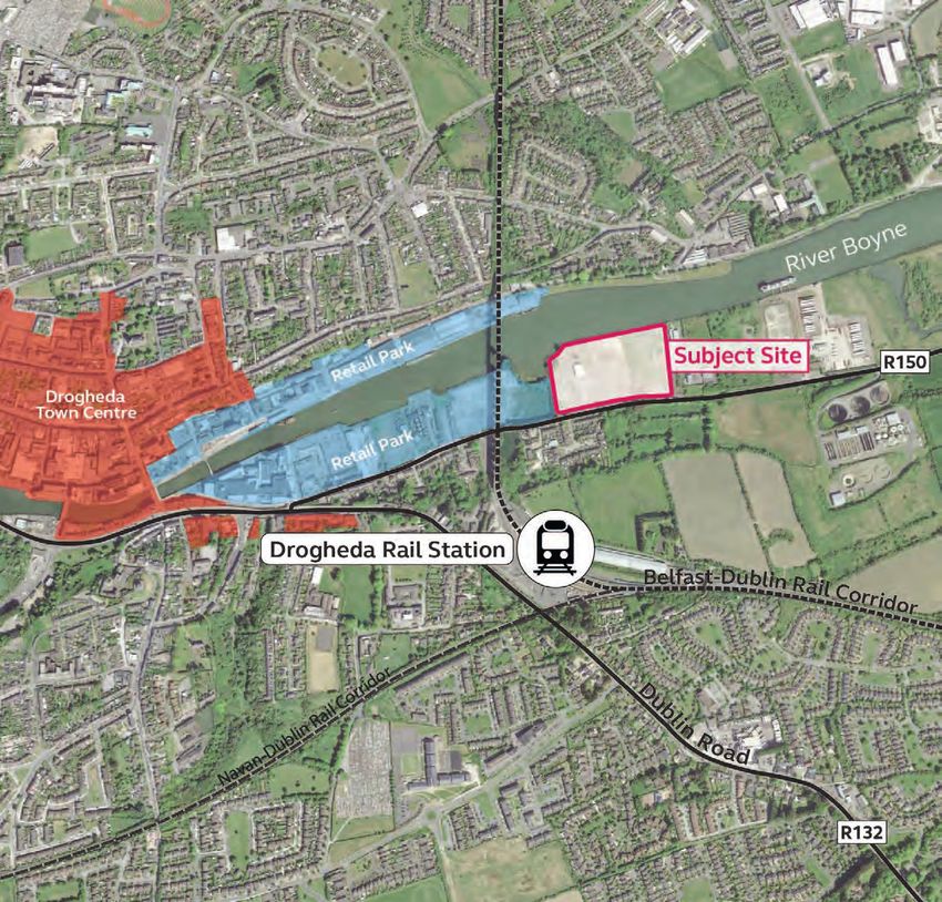
01 Introduction &
       Background

 1.1   Purpose of Report
 1.2   Subject Lands
 1.3   Site Location (National)
 1.4   Site Location (Local)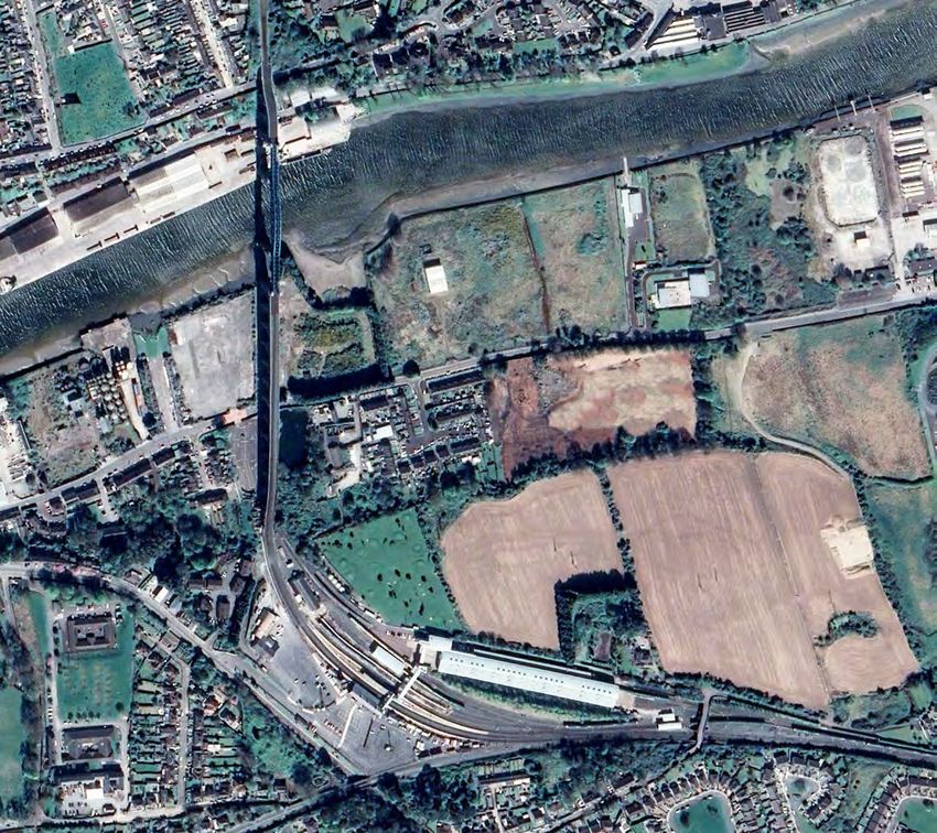
01 Introduction & Background
1.1 Purpose of Report
The Planning Authority is commencing the
preparation of the County Development
Plan (CDP) for the county to cover the period
2021 to 2027. The purpose of the CDP is to
set out an overall strategy for the proper
planning and sustainable development of
the county.
Genesis Planning have been engaged by PJ & EJ
Doherty Ltd. to examine and assess the existing
policy context in Drogheda and to prepare this
submission to the Planning Authority on their
behalf.
In terms of background our client is in ownership
of the subject lands in the Marsh Road/
Bryanstown area of Drogheda, and is currently
examining options for moving the lands forward
for development.
In preparing this submission we have undertaken
an analysis of our client’s lands in the context of
the National Planning Framework, the RSES, the
current Louth CDP 2015-2021 and the Drogheda
Borough Council Development Plan 2011-2017.
The analysis undertaken by Genesis Planning
identified a number of areas of interest which
demonstrate that the subject lands are suitable
for residential development.
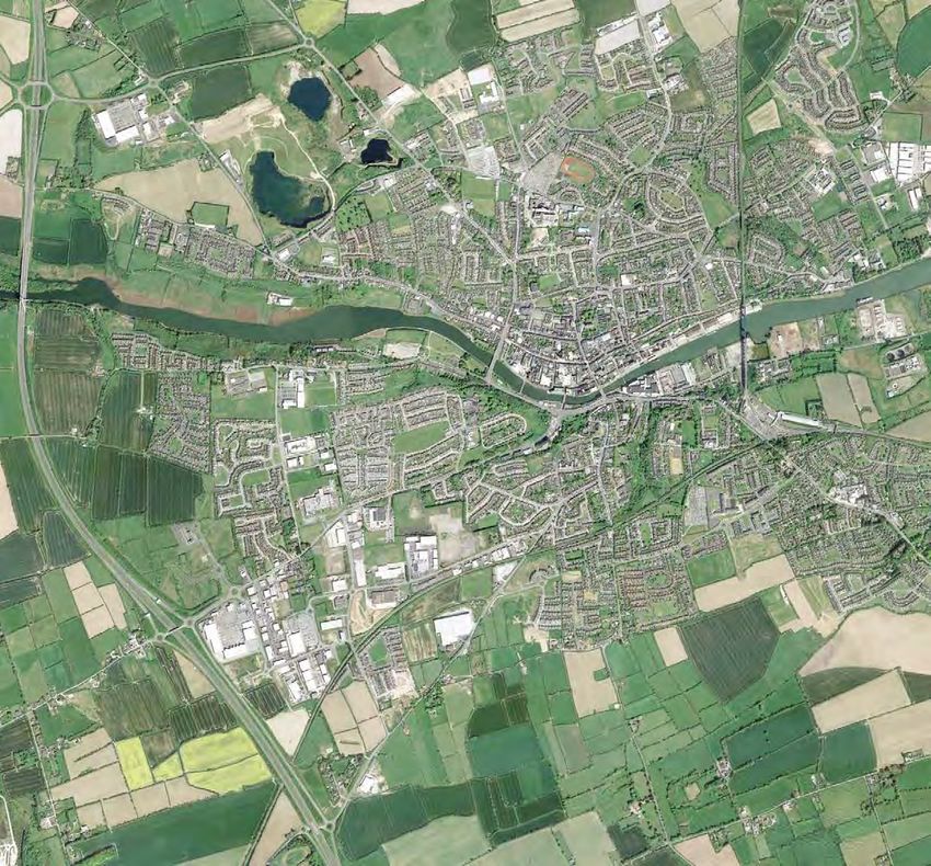
1.2 Subject Lands
In totality the subject lands occupy approximately
4.7ha along Marsh Road (R150) in the Bryanstown
area of Drogheda, approximately 1.5km east of
what would be considered Drogheda Town Centre.
The northern boundary of the site is defined by
the River Boyne, occupying approximately 300m
of the Rivers southern bank.
Key
We submit the subject site would provide a suitable
Land zoned for retail under
location for a residential development.
DBCDP 2011-2017
This submission outlines the planning rationale Land zoned as town centre
for the subject lands to be included as zoned under DBCDP 2011-2017
residential in the forthcoming CDP.
3 4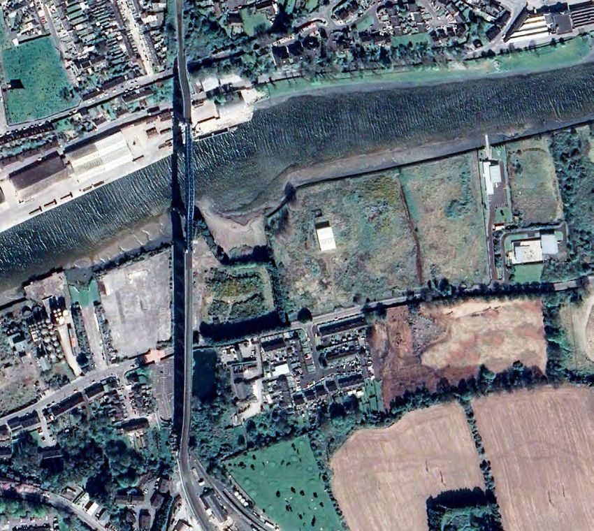
01 Introduction & Background

1.3 Site Location: National
The site is located within the regional growth            As the Planning Authority will note under the
town of Drogheda - the fastest growing town               NPF, Drogheda is prioritised as a cross-border
in the Country during the most recent inter-              network settlement and is targeted for growth
census period (RSES). In terms of zoning                  and investment in respect of the Dublin-Belfast
the site is located to the east of the town               economic corridor. The NPF reaffirms the ambition
                                                          for Drogheda to grow to city scale.
centre on zoned lands that currently permit
employment generating development.
                                                          Key to the success of Drogheda as a self-sustaining
                                                          regional growth centre is targeted compact
In terms of local demographic context, Drogheda           growth through the renewal and regeneration of
has a population of circa 40,000, with a target           underused, vacant and/or derelict town centre
of being a regional driver of city scale with a           lands for residential and commercial development.
population of 50,000 by 2031.
                                                          The DART extension programme will also see                          Ports
With regards to the socio-economic context, there         significant infrastructure investment in the
are a large number of multi-national companies            nearby MacBride Train Station. Therefore given                      Gateways
across a wide range of sectors located in Drogheda,       the proximate location of the site to the town
and in conjunction with the economic growth of            centre, the train station, as well as areas zoned for               Hubs
the town, there has been a steady increase in the         employment purposes, the subject lands provide
local population over the past couple of decades.         an ideal location for residential development.                      NI Cities

                                                                                                                              Principle Corridor

                                                                                                                              NI Rail

                                                                                                                              Irish Rail

                                                                                                                              Indicative NI Links

                                                                                                                              M1 Motorway

                                                                                                                              Northern Ireland

                                                                                                                              Project Site

                                                                                                                                      Drogheda
                                                                                                                                             Dublin

                                                                                                                  Drogheda Context within Dublin-
Drogheda is recognised in the RSES as a regional growth centre with ambitions to reach city-scale.                Belfast Economic Corridor

 5                                                                                                                                                    6
01 Introduction & Background Project site in the context of
the wider Drogheda area
Du
bl
in
Ro
DIFE
ad
1.4 Site Location: Local Boyne Rugby Club
/ R1
Belfast-Dublin Rail Corridor
M1 Retail Park
3 2
The subject lands comprise approximately
4.7ha which are strategically located east Boyne Business Park
of Drogheda Town Centre, on the southern Lourdes Stadium
bank of the River Boyne.
Drogheda United FC
Oliver Plunketts GAA Our Lady Hospital
The remainder of the site is bound by Marsh
Road to the south (from which there are multiple
existing access points), open undeveloped land to
the west and Inver Colpa Rowing Club to the east.
Our Ladys
There are a number of structures existing on the Mary McAleese Bridge Magdalene Tower
site, mainly warehouse/storage buildings which
are currently vacant. The residual area of the site River B Boyne Viaduct
remains undeveloped with the exception of ESB oyne Project Site
and eircom poles.
50
a rsh Road/R1
Town Centre M
In terms of immediate location and connections,
Marsh Road connects Drogheda Town Centre with Scotch Hall
Mornington and Donacarney and runs on an east –
DTDA
west axis parallel to the River Boyne. Drogheda Train Station
Ballsgrove
The lands are also close to Drogheda Train Station,
Drogheda Port, Drogheda Town Centre and less
than 5km from junctions 8, 9 and 10 of the M1 M1
Corridor. The existing Weirhope Bus Stop is located
Tredagh
on the south east boundary of the site is served by
frequent bus services to and from the town centre.
Donore Road Industrial Estate Southside Medical Centre
The lands also have existing pedestrian access to
d
the town centre along Marsh Road
Roa
e Funtasia
or
Being immediately adjacent to the River Boyne, om
we note there are a number of environmental Dr r rid
or Wolfe Tones GAA
designations located to the north of the subject o
il C
lands associated with the river including: Ra
in
Drogheda Retail Park u bl
• Boyne Coast and Estuary SAC
D
• River Boyne and Blackwater SAC n-
va
• Boyne Estuary SPA
Na
Overall the site enjoys good road frontage with
the R150 forming the southern boundary of the
site, as well as significant frontage along the River
which is a huge asset.
With services already existing on site as well as
direct access at multiple points along the R150 we Boyne Brewhouse
submit this site should be prioritised for residential 0 250m 500m 1km
development in the forthcoming CDP.
7 8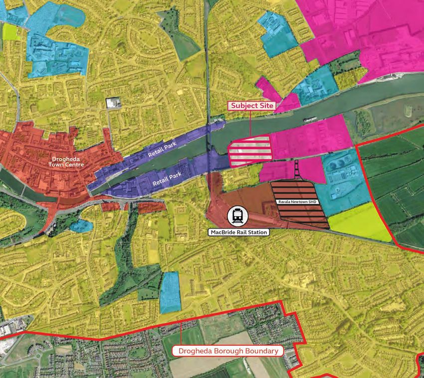
02 Policy

 2.1 National Policy Context
 2.2 Regional Policy Context
 2.3 Local Policy Context
02 Context
2.1 National Policy Context • Objective 7 ‘Apply a tailored approach to urban
development, that will be linked to the Rural
and Urban Regeneration and Development
The National Planning Framework 2040 sets Furthermore, we highlight a number of objectives Fund, with a particular focus on:
out the importance of development within contained within the NPF which relate to the
subject lands, such as: - Strengthening Ireland’s overall urban
existing urban areas, and sets out strategic structure, particularly in the Northern and
objectives which Planning Authorities are to Western and Midland Regions, to include the
have regard to. • Objective 2b ‘The regional roles of... Drogheda-
regional centres of Sligo and Letterkenny in
Dundalk-Newry cross-border networks will the North-West, Athlone in the Midlands
Under the NPF Drogheda is recognised as a be identified and supported in the relevant and cross-border networks focused on...
regional growth centre in the context of the Regional Spatial and Economic Strategy.’ Drogheda-Dundalk-Newry on the Dublin-
Dublin-Belfast corridor, and being of importance Belfast corridor;
due to its links with Dundalk and Newry. Drogheda • Objective 3a ‘To deliver at least 40% of all
is to be targeted for growth and investment as a homes nationally within the built-up footprint - Reversing the stagnation or decline of many
key driver for the border region. of existing urban settlements.’ smaller urban centres, by identifying and
establishing new roles and functions and
Key policies of the NPF in this regard include ‘a • Objective 3b ‘Deliver at least 30% of all new enhancement of local infrastructure and
focused approach to compact, sequential and homes that are targeted in settlements other amenities’; and
sustainable development of the larger urban areas than the five cities and their suburbs, within
along the Dublin- Belfast economic and transport - ‘Encouraging population growth in strong
their existing built-up footprints.’
corridor, along which there are settlements with employment and service centres of all sizes,
significant populations such as Dundalk and supported by employment growth.’
Drogheda.’ (p. 35) • Objective 4 states to ‘ensure the creation of
attractive, liveable, well designed, high quality - In more self-contained settlements of all
urban places that are home to diverse and sizes, supporting a continuation of balanced
integrated communities that enjoy a high population and employment growth.’
quality of life and well being.’
• Objective 11 ‘In meeting urban development
• Objective 5 ‘To develop cities and towns requirements, there will be a presumption in Extract from NPF relating to the Dublin to Belfast
of sufficient scale and quality to compete favour of development that can encourage Eastern Economic Corridor
internationally and be drivers of national and more people and generate more jobs and
regional growth, investment and prosperity.’ activity within existing cities, towns and villages,
subject to development meeting appropriate Summary
• Objective 6 ‘Regenerate and rejuvenate cities, planning standards and achieving targeted We submit that the subject lands are appropriate
towns and villages of all types and scale as growth.’ for residential zoning as envisaged by the NPF
environmental assets, that can accommodate given:
changing roles and functions, increased • Objective 13 states ‘In urban areas, planning
residential population and employment activity and related standards, including in particular • The subject lands are serviced; under the tiered
and enhanced levels of amenity and design building height and car parking will be based approach set out in the NPF these lands should
quality, in order to sustainably influence and on performance criteria that seek to achieve therefore be prioritized under the development
support their surrounding area.’ well-designed high quality outcomes in order to plan process.
achieve targeted growth.’
• Objectives 2b, 3a, 3b, 4, 5, 6, 7, 11, 13, 35 and
• Objective 35 states ‘Increase residential 44 of the NPF are complied with.
density in settlements through a range of
measures including reductions in vacancy, re- • The lands are in close proximity to the town
use of existing buildings, infill development centre, MacBride train station, and a number
schemes, area or site-based regeneration and of significant employment centres.
increased building heights.’
• The development would see significant
• Objective 44 states ‘In co-operation with regeneration of a brownfield, infill site along
relevant Departments in Northern Ireland, to the Boyne waterfront.
further support and develop the economic
potential of the Dublin-Belfast Corridor and in • The subject lands are sequentially acceptable,
particular the core Drogheda-Dundalk-Newry contiguous to existing developed lands and in
network and to promote and enhance it’s close proximity to the urban core of Drogheda.
international visibility.’
11 12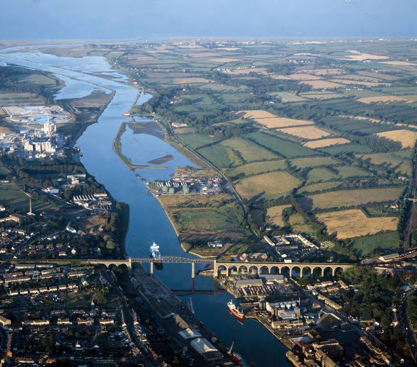
02 Context
2.2 Regional Policy Context
The RSES for the Eastern and Midland • Target significant growth in the Regional
Region (EMRA) sets out the strategic Growth Centres of Athlone, Drogheda and
plan and investment framework aimed to Dundalk to enable them to act as regional
‘shape future development and to better drivers, with a focus on improving local
manage regional planning and economic economies and quality of life to attract
investment and the preparation of urban area
development throughout the Region.’
plans.
In line with the NPF, Drogheda is recognised by • ‘Drogheda to realise its potential to grow to
the Regional Spatial and Economic Strategy for city scale and secure investment to become
the Eastern and Midland Region (RSES2018) as a a self-sustaining Regional Growth Centre on
regional growth centre and a regional driver with the Dublin-Belfast Economic Corridor, driving
‘significant sustainable growth potential’. synergies between the Drogheda-Dundalk-
Newry cross border network.’
The policy for the Dublin-Belfast corridor
encourages focused growth in the Regional • ‘Safeguard and improve accessibility and
Growth Centres of Drogheda and Dundalk to grow service by rail, road and communication
to city scale, with both having been identified between Dublin and Belfast and drive cross
for significant population growth to achieve a border networks between Drogheda, Dundalk
and Newry. Post–Brexit, consideration should
population in the region of 50,000 by 2031.
be given to a process that can establish
protocols for environmental protection and
In this context Drogheda is also identified as one of movement of people and goods.’
the key settlements that is critical to the success
of both the RSES and NPF. It is recognised by the • ‘Facilitate the regeneration of lands at
RSES that regional drivers: MacBride Station to capitalise on existing
and planned public transport infrastructure,
‘will accommodate significant new investment in including the DART Expansion Programme
housing, transport and employment generating whilst avoiding development that detracts
activity. They are important self-sustaining centres from the town centre.’
that act as economic drivers for the Region,
capitalising on their strategic location and high- • Also specific objectives relative to Drogheda in
quality connections to Dublin, while also servicing the RSES include RPO’s 4.11 to 4.18, 4.20, 6.3,
6.30, 8.6, 8.8, 8.11, 8.12 and 8.22.
and supporting a wider local economy’.
In terms of the development strategy outlined in
the RSES, in relation to Drogheda it echoes the
NPF in that it states: Summary
As the subject lands are strategically positioned
• ‘Facilitate collaboration to support the within the settlement boundary of Drogheda,
development of the Dublin-Belfast Economic
the zoning of the subject lands for residential
Corridor, to drive synergy in the Drogheda-
development is consistent with the objectives set
Dundalk-Newry cross border network.’
down by the RSES. The subject lands will improve
• ‘Compact and focused growth in the Regional the supply of residential units for Drogheda in
Growth Centres of Drogheda and Dundalk to a sustainable manner, facilitating compact and
grow to city scale.’ focused growth, consolidation of the urban area as
well as brownfield, infill and waterfront regeneration.
Extract from RSES for EMRA relating to the Functional Urban Areas and Large Towns CSO 2016
13 1402 Context
2.3 Local Policy Context DROGHEDA BOROUGH
COUNCIL
The current Louth CDP sets out the strategic LAND USE ZONING OBJECTIVE MAP
land use objectives and policies for the ZONING OBJECTIVES
overall development of the county up to
the year 2021, acting as a guide for those RE.
Residential existing :To protect and/or improve the
amenity of developed
interested in pursuing development and to residential communities.
inform development proposals. Residential New :To provide for new residential
RN. communities and community facilities and to protect
existing residential development.
In terms of settlement hierarchy, under the current
CDP Drogheda has been identified as a Level 1 – TC.
Town Centre :To protect and enhance the special
physical and social character of the existing town centre
Large Growth Town, specifically it states: and to provide for new and improved town centre
facilities and uses.
‘Over the last decade, the town has experienced TCd.
Docklands : To Provide for a mix of new town centre
activities in accordance with Docklands
significant growth principally resulting from its Area Plan.
location close to Dublin, the completion of the
motorway and improvements to rail commuter
Retail park : To provide for the development of a retail
RP. warehouse park inaccordance with an approved
framework plan and subject to the provision of necessary
services. physical infrastructure.
EGZ. Employment Generating Zone:To provide for the The
Development Of Business And Employment Generating
While acknowledging Drogheda’s role as a Business Activity ,which is Primarily
Manufacturing,Service Orientated and whose Retail
commuter town, the Council is keen to support the
Output is Ancilliary to the primary use.
policies and objectives of the Drogheda Borough
Council Development Plan, particularly having
Business Park/ New Economy Business: To provide for
BP. new Business Opportunities on a Green Field Site.The
Zone allows for Flexibility in the Composition of uses
regard to the objective of developing the town Allowed,subject to the preparation of a site masterplan.
To include a maximum 25 % residential and 16.5 % usable
as a self-sustaining Primary Development Centre
public open space.
that will energise development within its own Civic Community & Institutional: To Provide &
CCI .
catchment.’
Protect necessary Community ,Recreational &
Educational Facilities.
In terms of current zoning, the provisions contained RRO . Redevelopment or Renewal of Obsolete Areas:
Further study required to determine future use
within the CDP accord with the Drogheda
Borough Council Development Plan (2011-2017; DTDA. Drogheda Transport Development Area:To protect
as extended).
and expand the existing Transport Hub around the train
station and facilitate the development of Public Transport
facilities including Residential ,Retail and Office
Development.
The subject lands are designated in the DBCDP Neighbourhood Centres:To Protect, provide for and
NC .
2011-2017 as ‘EGZ’ (Employment Generating improve Local Shopping Facilities in order to create and
retain a vibrant and sustainable Neighbourhood Centre to
Project Site
Zone) and ‘OS’ (Open Space & Recreational. The
serve Primarily Local Needs.
zoning objectives of both designations can be seen LPS . Local Primary shops.To Protect,Provide for and
opposite.
Improve Local Shopping Facilities in order to Provide
Facilities for a Residential Neighbourhood.
Open Space and Recreational
OS. Area:(Public/Private)To provide for and /or improve DROGHEDA BOROUGH
COUNCIL
open space and recreational amenities.
LAND USE ZONING OBJECTIVE MAP
ZONING OBJECTIVES
Summary
Residential existing :To protect and/or improve the
RE. amenity of developed
residential communities.
Residential New :To provide for new residential
RN. communities and community facilities and to protect
existing residential development.
District centre.To Create A Sustainable District Centre
DC . Outside the Town Centre which will Operate as a
TC.
Town Centre :To protect and enhance the special
physical and social character of the existing town centre
and to provide for new and improved town centre
facilities and uses.
With existing residential development located
Complementary Retail Hub to the Existing Town Centre. TCd.
Docklands : To Provide for a mix of new town centre
activities in accordance with Docklands
Area Plan.
Retail park : To provide for the development of a retail
RP. warehouse park inaccordance with an approved
framework plan and subject to the provision of necessary
physical infrastructure.
immediately south of the subject site (Weirhope
EGZ. Employment Generating Zone:To provide for the The
Development Of Business And Employment Generating
Business Activity ,which is Primarily
Manufacturing,Service Orientated and whose Retail
Transportation Corridors. (Roads.) Output is Ancilliary to the primary use.
Business Park/ New Economy Business: To provide for
BP. new Business Opportunities on a Green Field Site.The
Zone allows for Flexibility in the Composition of uses
Allowed,subject to the preparation of a site masterplan.
Housing Estate) and an application for 456 units
To include a maximum 25 % residential and 16.5 % usable
public open space.
Transportation Corridors. (Bridges ) CCI . Civic Community & Institutional: To Provide &
Protect necessary Community ,Recreational &
Educational Facilities.
Redevelopment or Renewal of Obsolete Areas:
RRO .
around MacBride Station as part of DTDA (deemed
Further study required to determine future use
Drogheda Transport Development Area:To protect
DTDA. and expand the existing Transport Hub around the train
Drogheda Borough Boundary. station and facilitate the development of Public Transport
facilities including Residential ,Retail and Office
Development.
Neighbourhood Centres:To Protect, provide for and
NC .
acceptable by the Bord and Planning Authority), we
improve Local Shopping Facilities in order to create and
retain a vibrant and sustainable Neighbourhood Centre to
serve Primarily Local Needs.
Local Primary shops.To Protect,Provide for and
LPS . Improve Local Shopping Facilities in order to Provide
Facilities for a Residential Neighbourhood.
Open Space and Recreational
OS. Area:(Public/Private)To provide for and /or improve
submit the subject lands are suitable for a residential
open space and recreational amenities.
District centre.To Create A Sustainable District Centre
DC . Outside the Town Centre which will Operate as a
Complementary Retail Hub to the Existing Town Centre.
Transportation Corridors. (Roads.)
Transportation Corridors. (Bridges )
development and should be zoned accordingly in the
(C) Ordnance Survey Ireland.All rights reserved. Drogheda Borough Boundary.
License number 2011 /30 CCMA Louth Local
Authorities.
DROGHEDA BOROUGH COUNCIL
upcoming CDP.
DEVELOPMENT PLAN 2011 -2017
COMHAIRLE THOGHLACH
DHROICHEAD ATHA
DROGHEDA BOROUGH COUNCIL
DROGHEDA BOROUGH COUNCIL
COUNCIL OFFICES
FAIR ST,
DROGHEDA,
CO. LOUTH.
Phone (041)9833511 Fax (041)9876184.
BOROUGH ENGINEER
DEVELOPMENT PLAN 2011 -2017 DRAWN
M.KIMMINS
Ordnance Survey Ireland.All rights
reserved.
License number 2011 /30 CCMA
SCALE
DATE
1:10,000
Louth Local Authorities. March 11
COMHAIRLE THOGHLACH
15 16
DHROICHEAD ATHA
DROGHEDA BOROUGH COUNCIL
COUNCIL OFFICES
FAIR ST,
DROGHEDA,
CO. LOUTH.03 Local Context
3.1 Site Context
3.2 Local Connections
3.3 Sequential Development
3.4 Residential Zoning
3.5 Proposed Zoning
(As Per Draft 2021-2027 CDP)
3.6 Recommended Zoning
3.7 Proposed Zoning & Context03 Local Context & Concept
Hand Street The Sycamores
3.1 Site Context
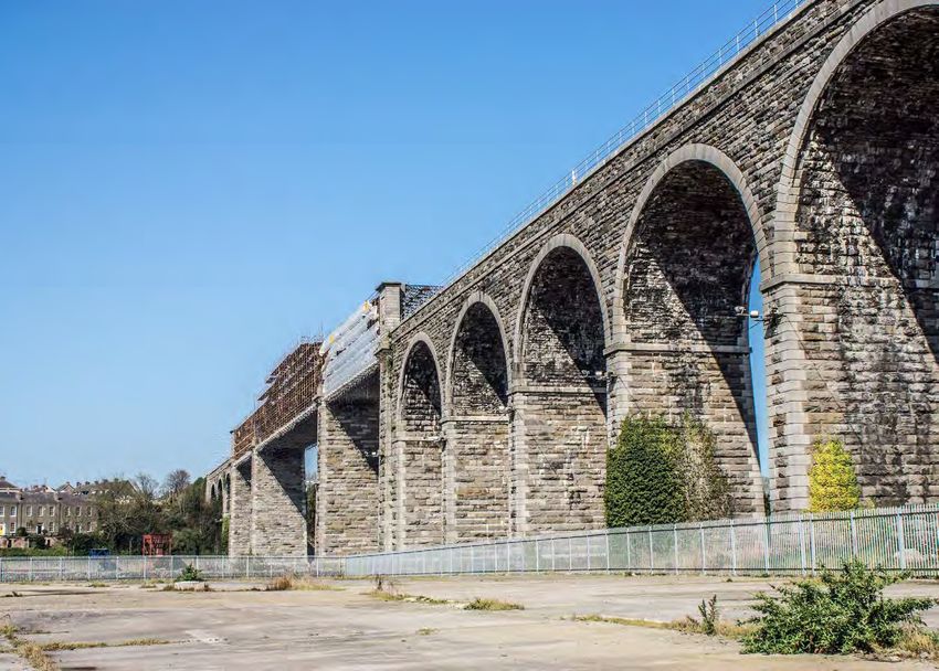
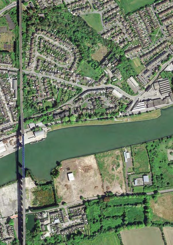
The subject lands are located north of
Marsh Road in the Bryanstown area east of
o r t h Strand/R167
Drogheda Town Centre, in close proximity N
to the Irish Rail Corridor, Drogheda Viaduct
and MacBride train station.
Boyn e
Consisting of a brownfield parcel of lands
measuring a total 4.7 hectares, the site borders
open undeveloped lands along it’s western R iv er
boundary, the River Boyne to the north, Inver
Colpa Rowing Club along the eastern boundary Drogheda Viaduct
Rowing C
Inver Col
and Marsh Road (R150) to the south.
Of relevance to the local context is the Ravala
Dublin-Belfast Rail Corridor
Newtown SHD which has been subject to a judicial
pa
lub
review challenge located to the south-east of the
subject lands. Although permission has not been g
granted, we note the location and principle for Existin using
o
Ravala SHD has been deemed acceptable by the Wareh
both the Planning Authority and the board.
In terms of existing site features, multiple access
points to the site already exist from Marsh Road
along the southern boundary, characterised by
R150
entrance railings and mature trees in places.
Marsh Road/
Ship St
Existing site conditions are characterised by
relatively flat lands with some existing unused
reet
warehousing located in the eastern section of the
site.
There are existing views of the site from the
immediate stretches of Marsh Road (R150), from Weirhope
Carm ges
adjacent residential properties in Weirhope as well Residences
Cotta
as from the Boyne river and portions of the north
Key
ellite
strand on the opposite site of the river. Ravala Newtown SHD
Marsh Road
(Foul Sewer & Water) Ref: PL15 .305110
Overall the site benefits from it’s location on the
river front, it’s proximity to Drogheda Town Centre Irish Railway Corridor 456 Units (Pending)
(one of the fastest growing towns in the state), as Trees/Hedgerows
well as it’s proximity to significant public transport
Existing Residential
infrastructure (MacBride Train Station, Weirhope
Bus Stops) and existing utility services along Subject Site
Marsh Road (R150)
Existing Site Access
0 50m 100m 150m
19 203KM
5KM
03 Local Context & Concept
L2318
nt
L2307
i es
5KM
G
ol
La
fC
ne
lu
b
R
oa
Drogheda (North)
d
Ki 10
ng
et
Bally
W
3.2 Local Connections
e
Str
ill
H
mak
ia
ron
's ill
m
G of Re
d
He
Ra s ha nk
enny
Go
le
t et
lf C
h
n
tre
L2321 D u nli n S
4KM
lu b
R oa
Ro
Marsh Road, which forms the primary road
d
ad
St. ross
e rn C
Drogheda Bypass
North
frontage of the site, connects Drogheda town
P
ete
r 's R166
Twe
centre with Mornington and Donacarney
Ch
St. P ete
estn
ntie
r's
For
and runs on an east–west axis parallel to the
ut G
s Lane
Townley s
est P
ro s
M onaste rb oice
C
Hall Golf R168 Northern
rov
Down Line
R132
C h e rr
ark
River Boyne.
Up Line
e
Club
M1 3KM w
oo
y
e v
d D ri
e
Li
N
Fai
n
sc
La
or
rG Newtown
Be
orr
ate ec
h wo o d D ri v e
th
ill
m
Blues
ie
W
The site is Cwithin
ounty Louth easy walking distance of
Ro
x
Fla
ark
Ballyp
ad
hit
Drogheda Bypass
Forest Hil l
Nor ern Cross N51
eth
Count Bea
DroghedaBoyne town centre and therefore hasthaccess to ulie
R166
orn
u Vie
M w
y
ea
Newfield
th ill Lane
ad
ss Lane Flaxm
all of the social infrastructure facilities of the town Cro d Ro
Newfield
Slane
R o ad R oa w
n
L1001 As l
2KM L2275 el
Newto
ca
core. In the immediate area the site enjoys good
No
il w
Slane Road
ad
O'Raghallaigh's nd Saint Joseph's
r th
Win ou
la
CLG d wf Secondary
access to schools at both primaryBoand yne secondary
Trí
Ne
o
mil
Ro
tR
l Road School
A sca
ad
field
Me
en
Ash
m
Ol a
llifo
level.
il l
db hA
Ce
rid Sla on rt
n Cr Westc o u
nt Par
ge eR
o ad us
Ashfield
Ro hro
Pearse Park
w
ad d La n Gle nvie
Fou
Drogheda (North)
k
e
Riverv
ntain
Canal Field
10 ark
Drogheda grammar school is located on
Fount
se P
P e ar Our Lady's ete
iew
Brugha St. P
Hill
Bóthar
1KM College
Sráid
ain Hill
Mornington Road, approx. 2km east of the site, and Bo
R899
Na Cil
y ne
which also shares it’s site with Le Cheile primary Ashfi
rg e's Street
Tho
el d
tre e t
Scarlet S
le
Lou
ouse
mas
gh
Oulster Lane
school. Also, An Bhradain Feasa, a gael-scoil, is bo L-1000 ad
ph
d Ro
Street
y
King
Oldbridge Road Trinity
Francis S
St. Peter 's Cor nd
Shee
G ar d e ns Ro pe Walk
Bo
located on mill road 2km south-east of the subject Green L Str
a
ary
S
Geo
Boyne
yn
an e rth St. M
tree
Boyne ad No
e
R168 Ro
lands. The sacred heart secondary school is located
treet
1607 rd ne
t
Fair S
treet Str
eet Co
Boy
W illia m
1.1km from the site via poorhouse lane. On these oad
Drog heda B
Riverbank Marsh R
The
basis the site is well served by local schools. L1002 Fa Drogheda all Road
Boro
Rathmullan Road ir eM rsh
Ga Ma
County Lout h
Th
te
R150
ugh
ypass
With regards to public infrastructure and service
D is
R132 Boyn e R167 Dublin Road
provision, MacBride train station is located
tric
t of
et
Highlands
approximately 300m from the project boundary.
e
The Dal
tre
Down Line
Dro
nt
Drogheda
lifo
yS
gh
MacBride
County Meath
Up Line
ar
l
Me
M
eda
nu e huire
Bailtini M
Dro
Ave
Of relevance we also note the RSES has also Ha
ll
Congress
gh
oad R108 ea
ton Wheaton Hall
eR
ed
e Sacred Heart Wh
confirmed the DART (Dublin Area Rapid Transit) L1005 Do
nor Pr iest Lan
aB
(Secondary School)
ypa
ne
d ge
will be extended to Drogheda (para. 5.6).
Marle
oa lla
La
R Vi
in
ss
Mo t
ush
ran
Pla
s n
Ter w D ub
y
to
Beam
ra n e
Blackb
's Lan
ce s lin Ro dla
n ad oo
R152 ra
By W
e
outh
Local bus services can also be accessed close by St. Mar
ew
unty L
Boyn
dow Vi
e
ore R
St.
Ma Mea Co
woo d
Elmwo
ry 's Long
ad
ood
Th e
with Weirhope bus stops located on the southern Elmw
Ce d
Ro
oad
The
y
Drogheda
re
rfi
Ca
od
's
a
eld
no
irn
Do vale
Cair
boundary, operating at 15min frequency to the 9 Rose iew
s
Rosevale ow V
Mead
ns
irns
T h e Ca Du
town centre and beyond via the D1 and D2 services. R ose
vale bli n
T he
Haz
Road
eath A rd
Ri Fi
yM ve
Millmoun
uth nt
el
ew Oa
Cou e Vi
Mu
aks
Beamor
d
o ks
Lane
en
yL ourw Th
a
A rd Ri F iv
t
Ro
Av e
nici
eO
un llag
L agav o oren Mano
eO
In terms of road access, junctions 8 and 9 of the
i
Co sV ak
tin
Boy
Fiv
M1 Oak
t
A rd Ri
p
sV
F ive
Pla
S qu
i lla
al D
e Road
ge
ne B
Co un ty Meat
motorway (M1) are less than 4km from the subject
ar e
h
istric
usin
site and can be readily accessed via Donore Road
e ss
t of
Knockbrack
Park
r
Layt
(Junction 9) or Platin Road (junction 8). Downs
own
Lagavooren
Drogheda
—
9
Be
tty
sto
Dr
og
wn
he
Key
da
By
pa
Bryanstown
ss
Railway Line L1601
S t. M 11
ary 's R108 L161
M1 Motorway 0 250m 500m 1km
k
lee 111
Du
Subject Site L16
Dr
1
og
h
21 2203 Local Context & Concept
3.3 Sequential Development
3KM
The merits of the sequential approach in
land use planning are well established. In
this regard, as the Planning Authority will
note, the development of land for residential
purposes is influenced by multiple factors 2KM
such as services, availability, accessibility
and existing infrastructure.
In response we submit the subject lands are an
example of why the sequential test should examine
each site in detail and not just look at it’s location. 1KM
We also highlight the sequential approach
is required under the NPF; specifically under
appendix 3 therein which seeks to prioritise ‘Tier
1: Serviced Zoned Land’.
In response we highlight the site is appropriate in
terms of sequential development given:
• The site is to be categorised as ‘Tier 1
Service Zoned Land’ as per the NPF and
should therefore be prioritised for residential
development.
• The site directly accessible from the existing
road infrastructure. Extant permission
• The site is serviced. 17387
• The site is included within the settlement Key
boundary of Drogheda, in close proximity to
the town centre. Retail Park
• The site is within walking and cycling distance
of local amenities and major public transport Recreation/Open Space
infrastructure.
• The site is sequentially the next available parcel
of lands for residential development and also Town Centre
represents brownfield infill development as
well as waterfront regeneration. Civic Community &
Institutional
We submit these attributes make these lands Drogheda Transport
strategically important in the overall development Development Area
of Drogheda.
Existing Residential
Delivery of a residential scheme via an appropriate
land use zoning on these lands should therefore be
supported by the Planning Authority in advance of New Residential
many other land parcels elsewhere in Drogheda.
Employment Generating 0m 250m 500m 750m
Zone
23 2403 Local Context & Concept
3.4 Residential Zoning
Population Change Housing Market
To provide an overview for the Planning On this basis the population growth experienced As the Planning Authority will note, the Notably this growth in prices of 192% is greater
Authority in terms of local population both at County Level and in Drogheda all exceed housing market in Drogheda has shown than that experienced in County Dublin where
change and demand for housing, this section the growth in the state (31.3%) and the GDA significant growth in recent years, influenced prices have increased by 69.9% (excluding Dublin
provides a brief outline of the population (37.5%) during the same period. by it’s own population, economic growth and City Centre where growth has been 94.2% since
growth of the State, the Greater Dublin Area also by the overall demands being exerted the trough).
(GDA), Co Louth, Drogheda & Environs and However we note growth in the St. Laurence Gate for housing units both in County Louth and
also St. Laurence Gate ED (where the site is ED fell below all of the above-mentioned rates at in the Greater Dublin Area. It is clear these increases in prices are reflective of
located) according to the CSO census data. 18.8% in the period from 1996-2016. Specifically the existing demand to live in the Drogheda area,
when considering the growth rate of County Louth On review and as set out in Table 1, we consider it both from local buyers and from those whose first
As can be noted from table 1 below, the population (39.8%) and Drogheda & Environs. (62% - almost is reasonable to assume this represents the natural preference would be to live in Dublin but due to
of County Louth grew by 39.8% between 1996 double that of the national average) over the growth of Louth’s population and the ongoing affordability issues they seek to reside in commuter
and 2016. Also, Drogheda & Environs has grown same period, this suggests a gross under-supply demand to live within commuting distance of towns such as Drogheda.
substantially between 1996-2016, from 25,282 in of residential development in this central area of Dublin City and along key transport corridors.
1996 to 40,956 in 2016, representing a population the town. Also, in terms of transactions data from the CSO
increase of 62%. Also, as is evident in relevant publications and for 2020 it shows that 34 market transactions took
statistics, there remains significant pressure on place in Drogheda (up to July 2020), with an average
At a more local level St. Laurence Gate ED (where the housing market in the Drogheda and Environs sale price of €248,554. On review, when compared
the subject lands are located), has grown by 18.8% area, with Drogheda being a more affordable and to average Dublin 1 sale prices of €351,667 for
from 1996 to 2016. accessible alternative to living in Dublin City. July 2020 it is evident Drogheda is a much more
affordable housing option for purchasers. Further,
However, on review of CSO data for new dwelling we note market evidence suggests in the price
completions it is noted that units constructed in range of €210,000 to €240,000 potential demand
recent years within County Louth still remains low, is at it’s strongest, particularly for three-bedroom
particularly for apartment unit provision. units.
Greater Drogheda & St. Laurence
Census Year State Co. Louth In terms of residential prices, the median price in
Dublin Area Environs Gate Summary
the Drogheda eircode area was €249,795 (June
1996 3,636,087 1,405,671 92,166 25,282 3,423 2020), which is growth of 192% since the trough It is submitted the current lack of availability of units
in April 2012 of €129,495. is demonstrative of a shortage of supply and there
2002 3,917,203 1,535,446 101,802 31,020 3,566 exists a clear need to provide additional residential
units which are appropriate both in terms of unit mix
% Change 8.0% 9.2% 10.5% 22.7% 4.2%
and affordability.
2006 4,239,848 1,662,536 111,267 35,090 3,801
2017 2017 2018 2018 2018 2018 2019 2019 2019 2019 2020 2020 2020
% Change 8.2% 8.3% 10% 13.1% 6.6% Louth
Q3 Q4 Q1 Q2 Q3 Q4 Q1 Q2 Q3 Q4 Q1 Q2 Q3
2011 4,588,252 1,804,156 122,897 38,578 4,004 Single
31 29 24 30 37 46 28 28 37 35 27 19 37
House
% Change 8.2% 8.5% 10.45% 9.9% 5.3%
Scheme
81 86 96 107 97 124 127 98 109 117 85 155 105
House
2016 4,761,86 1,907,332 128,884 40,956 4,068
Apartment 2 5 5 16 2 15 19 9 14 52 2 14 7
% Change 3.8% 5.7% 4.87% 6.2% 1.6%
Table 2: New dwelling completions in Louth, Type of Unit and Quarter (source: CSO)
Table 1: Population change of the State, the Greater Dublin Area, Louth and Drogheda & Environs and St. Laurence
Gate ED between 1996 and 2016 as derived from the CSO statistics
25 2603 Local Context & Concept
3.4 Residential Zoning
Vacancy Rate
Table 3 below shows the housing type and Further, our analysis has found that in terms
vacancy rate in County Louth, St. Laurence of existing apartment numbers it is noted that
Gate ED and the state respectively as per apartments form a low overall percentage of the
CSO data in 2016. housing mix within the county at only 4.6% of the
total residential stock.
On review it is noted the percentage of vacant
dwellings at County Level is extremely constrained On the basis of the above it is clear there is a
with 88.57% of units occupied and within St. need for more residential units to be provided
Laurence Gate ED it is 92.00%. This is extremely to accommodate the growing population within
high in comparison to the state figure of 85.22% County Louth and Drogheda & Environs, in
which demonstrates that both County Louth and particular for apartment units.
St. Laurence Gate ED have a lower rate of available
units than the remainder of the country. We consider this is reflected in the designation
of County Louth as a rent pressure zone since
Also, with ongoing population growth trends July 2019, which in turn correlates with market
evident from census figures this occupancy rate evidence that a higher vacancy rate is required
has increased in recent years as Drogheda is now to avoid excessive increases in rents or purchase Vacancy Rate of Housing Stock by County (geodirectory.ie) Apartment Units as a % of Housing Stock (geodirectory.ie)
classified as a rent pressure zone . prices and ensure a housing market functions
Further, at a county level it is noted from recent
efficiently.
Summary
figures that the vacancy rate in Louth is now
recorded at an extremely low rate of 3.7%.
• With Drogheda recognised as a regional growth • This growth together with the current lack of
centre in the context of a Dublin-Belfast corridor availability of units is demonstrative of a shortage
(to be targeted for growth and investment as a of supply and there exists a clear need to provide
key driver for the border region), we submit that additional residential units which are appropriate
the delivery of residential scheme on the lands both in terms of unit mix and affordability.
St. is consistent with the strategy and objectives
Louth County Laurence St. State
Louth as set out in the NPF. • This is reflected in the designation of County
Permanent Gate ED Laurence Permanent State % Louth as a rent pressure zone since July 2019,
County %
Dwellings Permanent Gate ED % Dwellings • As the subject lands are strategically positioned which in turn correlates with market evidence
Dwellings within the settlement boundary of Drogheda, that a higher vacancy rate is required to avoid
the proposed development is consistent with excessive increases in rents or purchase prices
Occupied 45,528 88.57% 1,529 92.00% 1,707,453 85.22% the objectives set down by the RSES in that it and ensure a housing market functions efficiently.
will improve the supply of residential units for
Temporarily Drogheda in a sustainable manner, facilitating • In summary, considering the above the proposed
1,158 2.25% 35 2.10% 50,732 2.53%
Absent compact and focused growth through the zoning of the subject lands for residential
Unoccupied consolidation of the urban area. development should be supported by the
761 1.48% 0 0.00% 62,148 3.10% Planning Authority.
Holiday Homes
• The population growth experienced at County
Other Vacant Level and the Drogheda and Environs Area,
3,952 7.68% 98 5.90% 183,312 9.15%
Dwellings all exceed the national growth rate (31.3%)
and the Greater Dublin Area (37.5%) from the
Total 51,399 100% 1,662 100% 2,003,645 100% period 1996-2016. St. Laurence Gate ED with
a growth of only 18.8% in the same period has
Table 3: Occupancy Rates of Existing Units been restricted by lack of dwelling unit provision.
27 2803 Local Context & Concept
3.5 Proposed Zoning (As Per Draft 2021-2027 CDP) 3.6 Recommended Zoning
The subject lands are designated as per the However, it is our considered assessment that the As the Planning Authority will note, the section 28 Going forward, as part of the 2021-2027 CDP we
published Draft CDP 2021-2027 as: current/proposed zoning for the site would be development plan guidelines state: request:
more appropriate as residential going forward, as
• ‘E1’ General Employment, and the site is located in what is can be considered a • Development plans should be strategic • The Planning Authority include the subject
• ‘H1’ Open Space residential area. lands within the settlement envelope for
• Development plans should be a catalyst for Drogheda.
On review we note these zoning designations are This is particularly the case going forward given the positive change and progress
• The subject lands are zoned in entirety for ‘A2
the same/similar to that contained within the existing residential context which surrounds the
site, as well as the nearby Ravala SHD proposal, • Development plans should anticipate future New Residential’.
Current Louth CDP (2015-2021) which accords
with the Drogheda Borough Council Development and extant permission reference 17387 which are needs on an objective basis • The Development Management zoning matrix
Plan (2011-2017; as extended). both located further away from the town centre also permits alternative uses to be acceptable
than our client’s lands. • Socio-economic development is to be in principle.
We also note that the current zoning designations promoted
are proposed to be maintained in the forthcoming The sequential approach for residential zoning(s) We refer to section 3.7 overleaf which
CDP 2021-2027. under the NPF are also again highlighted as demonstrates our justification is appropriate to
previously detailed in section 3.3 of this submission. the context.
Marsh Road/R150
Key
A2 New Residential
Proposed Zoning under Draft Louth CDP 2021-2027 Recommended Zoning under Louth County Development Plan 2021-2027
29 3003 Local Context & Concept
3.7 Proposed Zoning & Context
On our review of the zoning objectives and
the local context we highlight the surrounding
land uses in the immediate vicinity are compatible
oyn e
and supportive for a residential scheme on the
er B
Riv
subject lands. We highlight:
• The western boundary is defined by lands identified
as ‘Town Centre Docklands’; the objectives of
which are ‘to provide for a mix of new town centre Drogheda Viaduct
activities in accordance with the Docklands Area
Plan’.
• The northern boundary is defined by the River
Boyne, and this provides an ideal opportunity for a
high-quality residential scheme to bring residential
activity to this edge-of centre waterfront location.
R1 50
• The eastern boundary is defined by the existing Marsh Road/
Inver Colpa Rowing Club Clubhouse premises. and
opposite/south is the Weirhop Estate. A residential
scheme on the lands is appropriate to this context.
• Further south of the subject lands is the Louth
County Council LIHAF (Local Infrastructure
Housing Activation Fund) Road Scheme, which
provides access to the Drogheda Transport
Development Area (DTDA) via Marsh Road. This
Dublin-Belfast Ra
road scheme provides a clear upgrade to local Lo
road infrastructure to coincide with a residential
ut
scheme on the lands being developed.
hC
o.C
• Also, in terms of local zoning objectives we
o LI
highlight the objectives of the nearby DTDA is to
H AF
‘protect and expand the existing transport Ravala Newtown SHD
hub around the train station and facilitate the il C Ref: PL15 .305110
Sche
development of Public Transport facilities 456 Units
or
including residential, retail, and office
me
rid
development’ (emphasis added).
Key
or
• We again highlight the location and principle Marsh Road
for Ravala SHD has been deemed acceptable by (Foul Sewer & Water)
the both the Planning Authority and the board. Irish Railway Corridor
In this context we submit the subject lands are
brownfield, closer to the town centre, existing Town Centre Docklands Drogheda Train Station
infrastructure and community services than the
Ravala SHD site. Open Space / Recreation
Existing Residential
• In this context we submit that zoning the subject
lands as residential would be consistent and Proposed/Future Residential
appropriate in land use terms with the surrounding
land uses, and consistent with national, regional Subject Site
and local policy objectives.
0 50m 100m 200m
31 3204 Summary &
Conclusion
4.1 Summary & Conclusion4.0 SUMMARY & CONCLUSION
This submission relates to the subject lands • As the subject lands are strategically positioned • Given the proximity to Macbride Train Station (v) The site is sequentially the next available
at Marsh Road, Drogheda. within the settlement boundary of Drogheda, the site is ideally placed for a sustainable parcel of lands for residential development
the zoning of the lands for ‘A2 New Residential’ residential development to be delivered. and also represents sustainable infill
In summary this submission requests: is consistent with the objectives set down by development.
the RSES in that it will improve the supply of • Existing c ycle/footpaths provide good
• The Planning Authority include the residential units for Drogheda in a sustainable connections to services in the local area, namely • On our review of the zoning objectives and the
subject lands within the settlement manner through the consolidation of the core the R150 (Marsh Road) which is well serviced local context we highlight the surrounding
envelope for Drogheda. urban area. by public transport offering a 15minute bus land uses in the immediate vicinity would be
service (D1/D2 routes) to the town centre compatible with and complementary to a
• The population growth experienced at County with opportunity to continue onwards via the residential scheme on the subject lands.
• The entirety subject lands are zoned for Level and in the Drogheda and Environs Area public transport network available.
A2 New Residential. exceed the national growth rate (31.3%) and • With the provision of residential development
the Greater Dublin Area (37.5%) from the period • The LIHAF road being developed adjacent and on the subject lands going forward there will
• The development management zoning 1996-2016. to the west along Marsh Road also further be a better ratio of jobs-to-residents in an area
matrix permits alternative uses to be strengthens the suitability of these lands to be of Drogheda which is zoned heavily for future
acceptable in principle and open for • There is a clear shortage of residential units delivered for a residential development. industry/employment expansion.
consideration. being provided in Drogheda, particularly within
• The site is appropriate in terms of sequential
the St. Laurence Gate ED. • We also submit a residential development on
development given:
the lands wil be consistent with all National
Key points of this submission include: • This is reflected in the designation of County and Regional Policy objectives which seek to
Louth as a rent pressure zone since July 2019. (i) The site is to be categorised as ‘Tier 1 provide additional residential units on such
Service Zoned Land’ as per the NPF brownfield and infill lands.
• With Drogheda recognised as a regional growth • In terms of site context, the subject lands are and should therefore be prioritised for
centre in the context of a Dublin-Belfast corridor in close proximity to the MacBride train station. residential development. • We submit these attributes make these
(to be targeted for growth and investment as a (ii) The site is directly accessible from the lands strategically important in the overall
key driver for the eastern and midland region), • Given the DART is to be extended to Drogheda, existing and future road infrastructure. development of Drogheda, and consider it
we submit that the proposed zoning is consistent a residential development on the subject lands (iii) The site is included within the settlement appropriate for the Planning Authority to zone
with the strategy and objectives as set out in is wholly supported by all National planning the subject lands for ‘A2 - New Residential’ in the
boundary of Drogheda, in close proximity
the NPF. objectives which seek to deliver additional forthcoming CDP.
residential units within walking distance of to the town centre.
public transport nodes. (iv) The site is within walking and cycling
distance of local amenities.
35 36www.genesisplanning.co.uk
info@genesisplanning.co.uk
27 Patrick Street, Newry
Co. Down, BT35 8EB
T: (+44) 2830 493 001
The Lodge, Clownings
Straffan, Co. Kildare, W23 PN24
T: (+353) 45 571 862You can also read