Coastal Quarter SHD Planning Application - Mobility Management Plan Shankill Property Investments Ltd - Coastal Quarter - Bray
←
→
Page content transcription
If your browser does not render page correctly, please read the page content below
Coastal Quarter SHD Planning
Application
Mobility Management Plan
Shankill Property Investments Ltd.
June 2021
Notice
This document and its contents have been prepared and are intended solely as information for
Shankill Property Investments and use in relation to Ballymore Development Bray
WS Atkins International Limited assumes no responsibility to any other party in respect of or arising
out of or in connection with this document and/or its contents.
This document has 26 pages including the cover.

Document history
                                        Origin-                             Author-
 Revision       Purpose description      ated     Checked    Reviewed        ised          Date
 Rev 0        Draft for Review            AR         JW          JW           JW       26/02/2021
 Rev 1        Final Draft for Review      SK         CF          CF           CF       14/05/2021
 Rev 2        Planning                    SK         CF          CF           CF       31/05/2021

Client signoff
 Client                Shankill Property Investments Ltd.
 Project               Bray Coastal Quarter SHD Planning Application
 Job number            5193890

 Client signature
 / date

5193890DG0026 | 2 | June 2021
Atkins | 5193890dg0026 rev 2.docx                                                         Page 2 of 26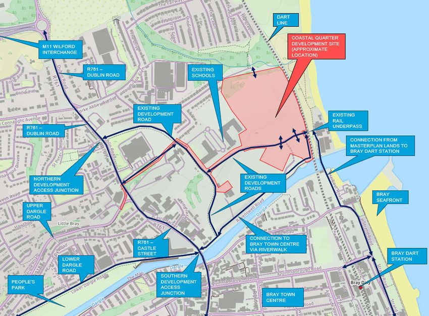
Contents
Chapter                                                                  Page
1.      Introduction                                                           4
1.1.    Overview                                                               4
1.2.    What is a Mobility Management Plan                                     4
1.3.    Accompanying Documents                                                 4
1.4.    Transport Planning Context                                             4
1.5.    Structure of This Document                                             6
2.      Existing & Future Conditions                                          7
2.1.    Subject Site                                                          7
2.2.    Local Land Use                                                        7
2.3.    Existing Local Road Network                                           7
2.4.    Proposed Road Network                                                 8
2.5.    Existing Walking and Cycling Facilities                               9
2.6.    Future Walking and Cycling Facilities                                12
2.7.    Public Transport Facilities                                          14
2.8.    Future Transport Proposals                                           16
3.      Objectives and Targets                                               18
3.1.    Objectives and Targets                                               18
3.2.    Proposed Development Mode Share                                      18
3.3.    Improved Mode Share Target                                           19
4.      Strategy and Measures                                                21
4.1.    Introduction                                                         21
4.2.    Strategy                                                             21
4.3.    Measures                                                             22
5.      Implementation, Monitoring and Review                                25

Tables
Table 1-1 - GDA Transport Strategy Objectives                                 5
Table 2-1 - Bus Services                                                     15
Table 2-2 - Existing Rail Services                                           16
Table 3-1 - Objectives and Targets                                           18

Figures
Figure 2-1 - Site Location                                                    7
Figure 2-2 - Existing Local Road Network                                      8
Figure 2-3 - Existing & Proposed Road Provision                               9
Figure 2-4 - Existing Pedestrian & Cyclist Connections                       10
Figure 2-5 - Active Travel Isochrones - 30 Minute Walking Isochrones         11
Figure 2-6 - Active Travel Isochrones - 30 Minute Cycling Isochrones         12
Figure 2-7 - Greater Dublin Cycle Network Plan Cycle Routes (Sheet 20)       13
Figure 2-8 - Existing & Future Pedestrian & Cyclist Connections              14
Figure 2-9 - Existing Public Transport Facilities                            15
Figure 2-10 - Future Public Transport Provision                              16
Figure 3-1 - Proposed Development Mode Share                                 19
Figure 3-2 - Improved Mode Share Target                                      19

5193890DG0026 | 2 | June 2021
Atkins | 5193890dg0026 rev 2.docx                                        Page 3 of 26
1. Introduction 1.1. Overview The Mobility Management Plan (MMP) sets out a strategy designed to promote travel by active and sustainable modes for the proposed Coastal Quarter residential development at Bray. The Coastal Quarter development is phase 1 of the Harbour Point Masterplan Development. This MMP forms part of a planning application and supports the Traffic and Transportation Assessment. In overall planning terms, the Coastal Quarter residential development consists of: 591 no. residential units 627 m2 Creche 249 m2 Convenience Store, 196 m2 Café 265 m2 Commercial (Office) A full description of the proposed development is included in the Planning Report & Statement of Consistency and full details of all pedestrian and cycle connections, road and street layouts, car parking and cycle parking are contained on the architects, landscape architects and engineering drawings and in the Engineering Planning Report (document reference 5193890DG0029). 1.2. What is a Mobility Management Plan A Mobility Management Plan is a strategic management tool designed to accommodate a site’s specific transportation needs. The MMP aims to educate people regarding how, why and when they need to travel. It provides a forum to promote and support the use of alternative, active and sustainable transport modes such as walking, cycling, shared transport and mass transit such as buses and trains. Consequently, the MMP will also assist in reducing dependency on private car and mitigate against traffic congestion and its inherent environmental, social and economic impacts. This document, the Mobility Management Plan (MMP) has been developed with specific reference to the site location, site context and proposed site layout and, describes the self-regulating management of travel demand. As such this MMP could help reduce the amount of car travel to and from the proposed development site at Woodbrook. Not only will this bring benefits to those employed on site or living within the development but also to the wider local community and environment. This MMP is not one fixed document but a dynamic and evolving mechanism for introducing and maintaining a package of measures. These measures focus on promoting access to the site by alternative, active and sustainable modes of transport and reducing single occupancy car travel. In general, the ultimate occupiers will be encouraged to put these measures into practice themselves. 1.3. Accompanying Documents An accompanying Traffic and Transport Assessment (TTA) reviews the potential transport impacts of the proposed development with respect to vehicular traffic and sets out the existing and proposed public transport, walking, and cycling infrastructure in the area. In addition, a Quality Audit (Access Audit, Walking and Cycling Audit & Stage 1 Road Safety Audit) accompany the MMP and TTA as part of the planning application. This MMP should be read in conjunction with the above documents and all planning, engineering and architectural reports and drawings. 1.4. Transport Planning Context A summary of the key policy documents pertinent to the proposed development and which have underpinned the proposals and the preparation of this MMP are as follows: 5193890DG0026 | 1 | June 2021 Atkins | 5193890dg0026 rev 2.docx Page 4 of 26
1.4.1.       Smarter Travel
The Smarter Travel Policy, published in February 2009, outlined the Governments vision for achieving
a sustainable transport system for Ireland by 2020. The document outlines a number of key policies
to encourage a modal shift away from private car use and promote alternative travel modes such as
public transport, walking and cycling.
In April 2009 the National Cycle Policy Framework (NCPF) was published. The policy outlined the
vision to develop the appropriate infrastructure to make all cities, towns, villages and rural areas
bicycle friendly and to promote cycling as the normal way to get about, in particular for short trips.
The aim of this framework was to encourage a culture of cycling to the extent that by 2020, some
10% of all trips will be completed by bicycle.
The proposed development incorporates the appropriate measures to enable the vision of both
documents by ensuring the development is fully accessible for all modes, providing good connections
to the existing and planned pedestrian, cycling and public transport links, both within Harbour Point
and on the external transport network.

1.4.2.       Transport Strategy for the Greater Dublin Area 2016 -2035
The Transport Strategy for the Greater Dublin Area (GDA) 2016-2035 established the framework for
transport provision for the city region. This Strategy, which is underpinned by the capital investment
program set out in the National Development Plan 2018-2027, is based on the following over-riding
objective;
“To contribute to the economic, social and cultural progress of the Greater Dublin Area by providing
for the efficient, effective and sustainable movement of people and goods.”
In particular, the Strategy aims to achieve a work commuting modal share target of 55% for
sustainable travel modes, reducing the single occupancy private car modal share to a maximum 45%,
as set out in Smarter Travel Policy.
The Strategy presents infrastructure proposals by mode of transport. Those that will particularly
benefit the proposed development are as follows;

Table 1-1 - GDA Transport Strategy Objectives
 Transport Strategy Objective                 Proposed Site Context
 Extension of Luas Green Line to Bray               Proposed route will run through the masterplan
                                                    lands into the existing Bray Dart Station. LUAS
                                                    stops will be provided within the masterplan
                                                    lands serving the development.
 Core Orbital Bus Network                           Existing bus corridor on Dublin Road on western
                                                    masterplan lands boundary to be upgraded as
                                                    Core Bus Corridor 13 of Bus Connects.
 Core Radial Bus Network                            Primary Route B1 is located on R761 Dublin
                                                    Road along the western masterplan lands
                                                    boundary. This route will be upgraded as part
                                                    of Core Bus Corridor 13 of Bus Connects.
                                                    Route 14 /N5, The East Coast Trail, is located
                                                    to the east of the Dart east coast rail line on the
                                                    masterplan lands site boundary. Connection to
                                                    this route from the development will be
                                                    facilitated via the Rail Underpass.
                                                    Route BG1 is located to the north of the Dargle
                                                    River on the southern masterplan lands
                                                    boundary, this scheme has been implemented
                                                    as part of the completed Bray Flood Defence
                                                    Scheme. This route will be maintained as part of
                                                    the masterplan lands layout and provides a high
                                                    quality link from the Coastal Quarter to Bray
                                                    Town Centre in under 5 minutes walking

5193890DG0026 | 1 | June 2021
Atkins | 5193890dg0026 rev 2.docx                                                            Page 5 of 26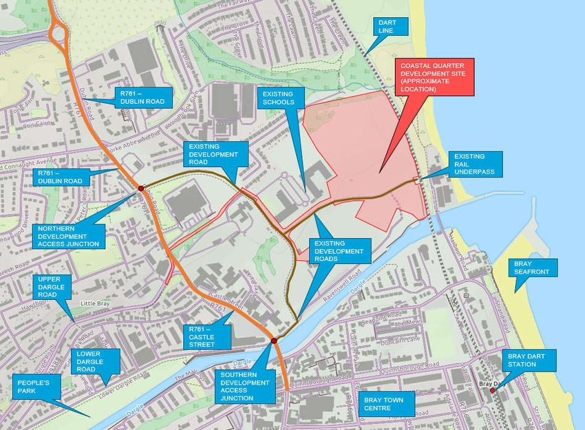
It should also be noted that policies and objectives from the Bray and Environs Transport Study, the
Bray Municipal Local Area Plan 2018-2024 and the current Wicklow and Dún Laoighaire Rathdown
Development Plans have also influenced this MMP. These are covered in depth within the Traffic
and Transport Assessment as contained under separate cover and accompanying this Planning
Application.
1.4.3. Best Practice and Planning Guidance Documents
The following best practice and planning guidance documents have fundamentally informed the
development of the site layout and the compilation of this MMP:
1. Transport Infrastructure Ireland: Traffic and Transport Assessments Guidelines.
2. Department of Transport Tourism and Sport: Design Manual for Urban Roads and Streets.
3. National Transport Authority: National Cycle Manual.
4. National Transport Authority: Permeability Best Practice Guidance.
5. Dun Laoghaire-Rathdown County Development Plan 2016 - 2022
6. Wicklow County Development Plan 2016 - 2022
7. National Transport Authority Advice Note – Mobility Management Plans 2002
Of particular importance is the Design Manual for Urban Roads and Streets (DMURS) published in
2013. This document is founded on an integrated design approach that is based on safety,
sustainable communities, heritage protection and creating a sense of place. DMURS recognises the
higher priority of pedestrians and cyclists in the urban environment within a fundamental design
objective to create self-regulating streets that are inherently convenient and safe for use by all
vulnerable road users. A DMURS Statement of Consistency (5193890DG0046) accompanies this
planning submission.
1.5. Structure of This Document
The MMP report provides the basis for the implementation of the MMP. It sets out the objectives and
measures to be put in place. Provisionally the MMP Report will be set out using the sections described
below:
Section 2 sets out the Existing Conditions in terms of local accessibility.
Section 3 establishes Objectives and Targets for the MMP.
Section 4 outlines the broad Strategy and Measures for the MMP.
Section 5 outlines the process for Implementation, Monitoring and Review.
5193890DG0026 | 1 | June 2021
Atkins | 5193890dg0026 rev 2.docx Page 6 of 26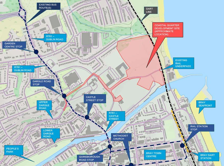
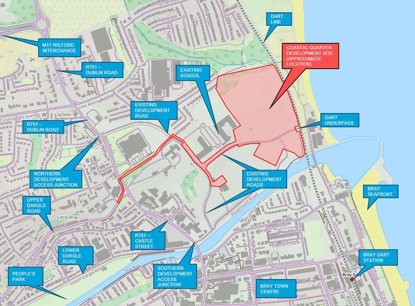
2.           Existing & Future Conditions
2.1.         Subject Site
The proposed development site comprises of lands located along the Dublin / Wicklow Border at
Ravenswell. The site is bordered by the Howth/Malahide to Greystones Dart line along the eastern
boundary. Located approximately 600m to the south of the site is the Bray Dart Station, where Bray
strand is located to the immediate East of the proposed development site.
The location of the site is shown in the Figure below.

Figure 2-1 - Site Location

2.2.         Local Land Use
Land uses in vicinity of the proposed development site are mainly residential. The development site
is neighboured by Woodbrook Glen housing estate along the north boundary, whilst also bordering a
small industrial estate to the west. As the development site continues south, it traverses the
Dublin/Wicklow County Border, leading directly to Bray Harbour.
In a wider context, significant population areas lie directly north and south of the proposed
development site namely Shankill and Bray respectively. Both of these locations also offer
employment and commercial land uses normally associated with a village and town centre
respectively.

2.3.         Existing Local Road Network
The proposed development site is located adjacent to a comprehensive road network consisting of
national roads, regional roads and local roads. The connections from the development to the existing
road network and connectivity to the wider area are outlined below and detailed in Figure 2-4:

5193890DG0026 | 1 | June 2021
Atkins | 5193890dg0026 rev 2.docx                                                        Page 7 of 26
Connection to the north via existing development road junction onto the R761 (Dublin Road)
providing connectivity to the M11 via the Wilford Interchange and to Dublin City via the R119.
Connection to the south via existing development road junction onto the R761 (Castle Street)
providing connectivity to Bray Town centre and to the west via Lower Dargle Road.
A full description of the local road network is contained within the TTA.
Figure 2-2 - Existing Local Road Network
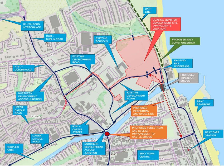
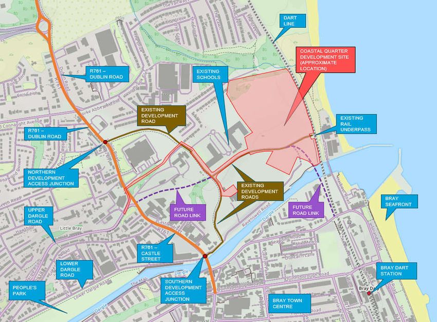
2.4. Proposed Road Network
The proposed road network is show in Figure 2-3 below and consists of the following elements:
The proposed BusConnects Core Corridor 13 scheme upgrade of the R761 and associated
junctions to facilitate a widened road corridor incorporating improved bus, cycle and pedestrian
facilities.
A new connection to Bray Dart Station will be provided via the proposed Public Transport Bridge;
Part 8 Planning has been lodged for this scheme ‘Pat 8 – Bray Sustainable Transport Bridge’ as
of July 2021 (Planning Reference PRR 21/869). This is in line with the requirements of Road
Objectives R05 of the Bray Municipal District Local Area Plan and will cater for public transport
bus and Luas services together with pedestrians and cyclists. The layout of the Coastal Quarter
and the proposed bridge has been coordinated with Wicklow County Council. A number of
meetings have been held between Wicklow County Council and representatives of the former
Golf Club Lands including pre-planning meetings in relation to the SHD planning application (Ref
ABP 308291-20). While the subject scheme has been designed to the existing road network, it
can also be adapted to the above referenced scheme should it be granted permission in the
future.
Improvements for pedestrians & cyclists are proposed on Castle Street Bridge as per the
requirement of Transport Objective R10 of the Bray Municipal District Local Area Plan. These
improvements consist of new pedestrian and cyclist bridges on both sides of the existing bridge
and the provision of southbound bus lane across the bridge
5193890DG0026 | 1 | June 2021
Atkins | 5193890dg0026 rev 2.docx Page 8 of 26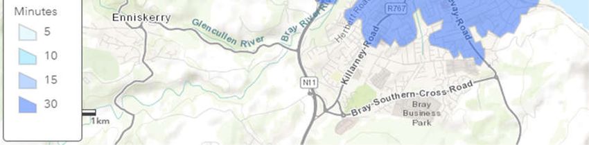
As part of the Masterplan for the full Harbour Point Masterplan a further development road linkage
is proposed at the existing traffic signal-controlled junction of the Upper Dargle Road. This is in
line with the requirements of Road Objectives R05 of the Bray Municipal District Local Area Plan.
This link will further improve permeability of pedestrians, cyclists and general traffic onto the local
road network.
Figure 2-3 - Existing & Proposed Road Provision
2.5. Existing Walking and Cycling Facilities
2.5.1. Walking and Cycling Provision
Footpath provision in general is adequate on surrounding roads with most offering footpaths of ample
width on both sides of the carriageway. There is an existing connection to Bray Dart station and Bray
Promenade via the Dart underpass, along with an existing connection to Bray Town centre via
Riverwalk along Dargle River and via the existing and proposed development roads. Dublin City can
be directly accessed via the R761 Dublin Road utilising the proposed cycling facilities. A future
connection will continue north along the proposed East Coast Greenway and south via the Proposed
Pubic Transport Bridge (Part 8 – Bray Sustainable Transport Bridge, Planning Reference PRR
21/869) into Bray Dart Station.
The existing pedestrian & cyclist connections are detailed in Figure 2-4 detailed below.
5193890DG0026 | 1 | June 2021
Atkins | 5193890dg0026 rev 2.docx Page 9 of 26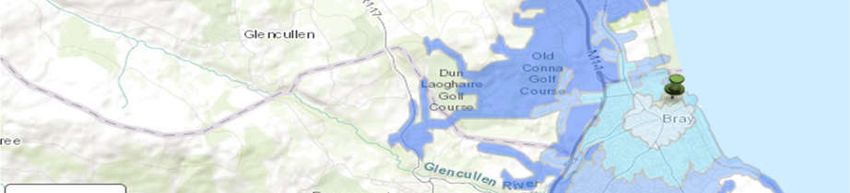
Figure 2-4 - Existing Pedestrian & Cyclist Connections

2.5.2.       Existing Walking and Cycling Isochrones
An analysis of the walking and cycling catchments in terms of journey distance and time has been
undertaken and the results of this are presented below. These are represented in the form of
isochrones radiating outwards from the proposed development site in 5 minute, 10 minute, 15 minute
and 30 minute journey time intervals.
In terms of walking Bray town centre is accessible within 10 minutes, whereas Bray Dart Station can
be reached within 15 minutes as detailed in Figure 2-5 below.

5193890DG0026 | 1 | June 2021
Atkins | 5193890dg0026 rev 2.docx                                                      Page 10 of 26
COASTAL QUARTER
                                                                                     DEVELOPMENT SITE

                                                                                         BRAY DART
                                                                                         STATION

Figure 2-5 - Active Travel Isochrones - 30 Minute Walking Isochrones

In terms of cycling, this catchment is extended further north leading directly to Shankill within a 30
minute cycle. To the south, the catchment is extended further along the R761 as detailed in Figure 2-
6 below. Bray Town Centre and Bray Dart Station is within a 5 minute cycle.

5193890DG0026 | 1 | June 2021
Atkins | 5193890dg0026 rev 2.docx                                                         Page 11 of 26
Figure 2-6 - Active Travel Isochrones - 30 Minute Cycling Isochrones 2.6. Future Walking and Cycling Facilities An extract of the Greater Dublin Cycle Network Plan is illustrated in the Figure 2-7 below detailed the future cycling facilities. 5193890DG0026 | 1 | June 2021 Atkins | 5193890dg0026 rev 2.docx Page 12 of 26
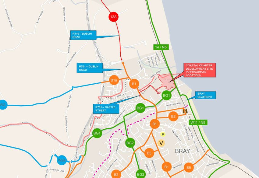
Figure 2-7 - Greater Dublin Cycle Network Plan Cycle Routes (Sheet 20)
The schemes that provide the facilities for the cycle network routes adjacent the development are
noted below:
Route B1 – BusConnects Core Corridor 13 Scheme will provide the facilities associated with
this route
Route BG1 – the facilities associated with the section of greenway route have been
implemented along the river front as part of the completed Dargle flood relief scheme
Route 14/N5 – East Coast Greenway Scheme will provide the facilities associated with this
route
Route N5/W11 – Stand Road Cycle Scheme provides the facilities associated with this route,
the final short section of this route is proposed to be implemented in 2021.
Details of the future pedestrian & cyclist connections in the context of the development are provided
below and detailed on Figure 2-8.
Development connection to the north into Existing Park Lands & Adjacent Development to
be provided as part of development
Connection to Bray Dart Station via proposed Public Transport Bridge to be provided as a
WCC Part 8 Scheme (Part 8 – Bray Sustainable Transport Bridge, Planning reference PRR
21/869) which has been lodged as of July 2021
Proposed Pedestrian & Cyclist Improvements on Castle Street Bridge, provision of pedestrian
and cycle footbridges either side of the existing bridge, to be provided by WCC
Improved pedestrian and cyclist facilities along the R761 Dublin Road provided as part of
BusConnects - Core Corridor 13 Scheme
East Coast Greenway Scheme Greater Dublin Cycle Network route N5 – incorporated within
WCC and DLRCC development plans
5193890DG0026 | 1 | June 2021
Atkins | 5193890dg0026 rev 2.docx Page 13 of 26 Completion of Strand Road Cycle Scheme at Marine Terrace under the NTA Stimulus
Programme 2020
Figure 2-8 - Existing & Future Pedestrian & Cyclist Connections
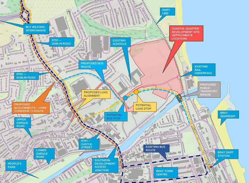
2.7. Public Transport Facilities
There are a number of existing public transport facilities available in vicinity of the proposed
development site ranging from bus services to rail services. Figure 2-9 provided below illustrates
these in the local context.
5193890DG0026 | 1 | June 2021
Atkins | 5193890dg0026 rev 2.docx Page 14 of 26Figure 2-9 - Existing Public Transport Facilities 2.7.1. Bus Routes and Services It is considered that the proposed development is well located, granting opportunity to access both services and employment opportunities in the local and wider environs via public transport. The available bus services are as follows. Table 2-1 - Bus Services Bus Service Route Frequency (Mon-Friday) 45a Dún Laoghaire Rail Station to Kilmacanogue 15-20min 45b Kilmacanogue - Dun Laoghaire Rail Station 15-20min 84 Blackrock to Newcastle 25-35mins 84a Blackrock to Bray 25-35mins 145 Heuston Rail Station to Ballywaltrim 10mins 155 IKEA (Ballymun) Towards Bray Rail Station 20mins 184 Newcastle Hospital to Bray Rail Station 30mins 2.7.2. DART Rail Services In terms of heavy rail, the closest Dart station is located in Bray, which is circa. 600m to the south, and Shankill Station which is circa. 2.7km to the north of the proposed development site. Both stations serve both DART and Commuter Rail services. These stations facilitate services that allow for good connection to other onward destination both north and south. The available rail services are as follows. 5193890DG0026 | 1 | June 2021 Atkins | 5193890dg0026 rev 2.docx Page 15 of 26
Table 2-2 - Existing Rail Services
 Rail Service       Route                                             Frequency (Mon-Friday)
 Dart               Malahide to Greystones / Howth to Greystones      5-10mins
 Commuter /         Dublin to Rosslare                                10 services
 Intercity
 Services

2.8.         Future Transport Proposals
The Transport Strategy for the Greater Dublin Area (GDA) 2016-2035 sets out how transport and its
associated infrastructure will be developed across the GDA region up to the year 2035.

The future public transport provision is detailed in Figure 2-10 with further detail provided in the
following sections.

Figure 2-10 - Future Public Transport Provision

2.8.1.       BusConnects
The NTA are currently developing the BusConnects Scheme, Corridor 13 Bray to UCD and City
Centre.
As the R761 lies on BusConnects Route 13 Bray to the City Centre, a full upgrade of the carriageway
and associated junctions will be provided along the R761. This will include for two-way provision for
traffic, buses, cyclist and pedestrians. This upgrade will have no impact on the Coastal Quarter
development proposals.

5193890DG0026 | 1 | June 2021
Atkins | 5193890dg0026 rev 2.docx                                                        Page 16 of 26
2.8.2.       Proposed Luas Extension of Green Line to Bray
The future Luas proposals, as set out in the Greater Dublin Area Transport Strategy include the
extension of Luas Green line to Bray. This line is not proposed to be developed until 2040 but it is
anticipated that the alignment will be adjacent the R761, into the development lands and into Bray
Dart Station via the proposed Public Transport bridge (Part 8 – Bray Sustainable Transport Bridge,
Planning reference PRR 21/869).
The proposals for the Riverside Quarter will include for the provision of a LUAS Stop/Luas Stops
within the development lands. The masterplan for the development lands takes cognisance of the
provision of the Luas extension and its interface with the development and locations of LUAS stops.

5193890DG0026 | 1 | June 2021
Atkins | 5193890dg0026 rev 2.docx                                                       Page 17 of 26
3. Objectives and Targets
3.1. Objectives and Targets
The objectives of the Mobility Management Plan Travel Plan are set with the overall aim of reducing
the number of single occupancy car trips associated with the residential elements of the development.
The objectives of the Coastal Quarter Development Outline Mobility Management Plan are as follows:
Achieve a high level of Community Awareness of the MMP.
Ensure a high level of Community Participation in the development of the travel surveys to
indicate participation.
Improve conditions for pedestrians and cyclists travelling to and from the site.
Develop on good urban design principles to enhance the permeability of the site and maximise
accessibility by sustainable modes.
Encourage the development of a healthy, sustainable and vibrant local community through
promotion of travel by sustainable modes.
The following Table outlines tangible targets to be achieved in relation to the key objectives.
Table 3-1 - Objectives and Targets
Objectives Residential Travel Plan Targets
Awareness To provide information on sustainable travel to each resident
upon occupation.
Participation To develop a detailed residential travel plan within 9 months of
first occupation.
Accessibility measures implemented to encourage walking, cycling, public
transport and car sharing from first occupation.
Maximise the Potential for To promote and encourage physical measures implemented as
Sustainable Travel part of the site layout to encourage sustainable modes of travel
from first occupation.
Reduce Car Related Travel To identify mode Share Targets to be agreed with Dun
Laoghaire Rathdown County Council / Wicklow County Council
following travel surveys.
3.2. Proposed Development Mode Share
The estimated proposed development mode share percentages for this location are detailed in the
chart below.
5193890DG0026 | 1 | June 2021
Atkins | 5193890dg0026 rev 2.docx Page 18 of 2614%
20%
8%
Car Driver
Car Passenger
Public Transport
Active Travel
Working from Home
28%
30%
Figure 3-1 - Proposed Development Mode Share
Details regarding the estimation of this proposed mode share are contained within the Traffic and
Transport Assessment, document reference 5193890DG0075.
3.3. Improved Mode Share Target
It is anticipated that mode share targets will be agreed with Dún Laoghaire-Rathdown County Council
and Wicklow County Council, following an initial travel survey to be undertaken following occupation
of the site. Targets identified will be set against the existing mode share established from the survey.
A timeframe will be set within which the targets should be achieved; however, the plan will be a lifelong
document evolving with the development of the site and addressing any changes in travel behaviour.
The proposed improved pedestrian & cyclist facilities, connections to public transport and Bray Town
centre and improved public transport services will improve upon the mode share as detailed in the
figure below.
11%
20%
5%
Car Driver
Car Passenger
Public Transport
Active Travel
30% Working from Home
34%
Figure 3-2 - Improved Mode Share Target
Further improvements to the mode share in terms of increased active travel (walking and cycling) and
public transport modes will be provided via public transports improvements and pedestrian and
cycling infrastructure improvements as proposed in the Dún Laoghaire-Rathdown County Council
and Wicklow County Council Development Plans.
In summary the proposed development mode share is an estimate, whilst the proposed mode share
noted above is an indicative target. Upon occupation and monitoring of the development mode share,
5193890DG0026 | 1 | June 2021
Atkins | 5193890dg0026 rev 2.docx Page 19 of 26an actual baseline mode share can be established. When this information and data becomes known, discussion s will be held with Dún Laoghaire-Rathdown County Council and Wicklow County Council to establish a target that is ambitious but achievable. 5193890DG0026 | 1 | June 2021 Atkins | 5193890dg0026 rev 2.docx Page 20 of 26
4.           Strategy and Measures
4.1.         Introduction
This section of the MMP sets out the Strategy and Measures proposed for the Coastal Quarter
residential development at Bray.
Clearly, as the users of the development are currently unknown at this stage the MMP can only
commit to promoting alternative modes of transport and providing the means for active and
sustainable travel choices to be made.
The starting principle is that the design and layout of the development is based on DMURS principles
that facilitates and encourages active and sustainable travel. This will lead to the adoption of more
sustainable modes of travel. The MMP will develop on the physical interventions of the development
proposals for the site layout. The physical interventions will be supported through the development
of ‘softer’ measures to encourage modal shift to active and sustainable transport.
This section describes the services to be provided and the ‘in built’ infrastructure measures (as part
of the layout and design of the development) which are intended to encourage use of active and
sustainable travel modes and complement the strategic aspects of the MMP.
The complementary measures will address the objectives, as set out in Section 3. These are to be
delivered through a co-ordinated strategy delivered by the Management Company and involving the
distribution of Travel Information Packs.

4.2.         Strategy
A fundamental aspect of this Mobility Management Plan is that it is a self-regulating plan. The
proposed development has thus been designed to include all of the necessary infrastructure to
support the self-regulating nature of the proposed development.
In particular the proposed development incorporates a number of unit types that support remote
working and learning through the provision of separate home office spaces. This will facilitate the
clear movement towards remote working that has been established during the Covid 19 pandemic
and associated restrictions. This movement to remote working is being facilitated and encouraged to
become the norm by the Government of Ireland as promoted within the National Remote Working
Strategy to be published this year. The NTA have also undertaken an assessment of the potential
future scenario post Covid 19 restrictions. The document ‘Alternative Future Scenario for Travel
Demand’ was published in December 2020 and outlines that an overall 8% reduction in traffic volumes
in the post Covid 19 restrictions era is anticipated in the alternative scenario. This is in comparison to
what would have been anticipated previously to the Covid 19 pandemic, associated restrictions and
resultant change in travel patterns and behaviours. The assumptions made in the traffic assessment
of the Proposed Development align with this anticipated future travel demand. As such these
proposals will facilitate the provision of long term, permanent and appropriate remote workspaces
within the home which will facilitate the ongoing avoidance and reduction of a substantial number of
trips.
In terms of trip reduction of longer distance trips, the proposed development clearly provides a high
level of connectivity to public transport including to bus and DART.
In terms of local trip making, the proposed development provides high pedestrian and cyclist
connectivity to local educational, services and amenity sites.
The above infrastructure is also complemented through the provision of a low quantum of car parking
spaces and a provision of high quality and high quantum of cycle parking spaces.
The proposed Coastal Quarter development thus presents as a development wherein residents will
be facilitated to undertake a lifestyle that has a low dependency on car ownership. This opportunity
is based on the multi-faceted characteristics of the site location and opportunities created for travel
choice and thus significantly mitigates the need to travel by car.
Travel Information Packs will form part of the marketing material for the site and will be distributed to
all new residents within the development at point of sale. These will be distributed by the
Management Company. The details of the Travel Information Packs would be provided to both
County Councils.

5193890DG0026 | 1 | June 2021
Atkins | 5193890dg0026 rev 2.docx                                                             Page 21 of 26
The Travel Information Packs would ideally contain the following information:
Information about public transport and locations of bus stops and rail stops and services;
Information about walking and cycling routes;
Information about car parking management;
Information about local services and facilities that are within comfortable walking distance;
Information on active and sustainable transport measures facilitated by the development
(bicycle parking, car sharing scheme, EV charging, etc.);
Through a monitoring and review process, the Management Company will also be responsible for
ensuring that the measures proposed are implemented in the most effective way possible.
4.3. Measures
The following measures will be promoted to encourage walking as a mode of travel by future residents
of the development:
4.3.1. Walking
There are many local, global, and personal benefits to walking, such as the following:
W - Wake Up! - Studies have shown that individuals who walk to work, school or elsewhere are
more awake and find it easier to concentrate.
A - Always one step ahead - Walking makes people more aware of road safety issues and helps
them develop stronger personal safety skills.
L - Less congestion - If you leave the car at home and walk, there are fewer cars on the road
which makes it safer for those who walk and cycle.
K - Kinder to the environment - By leaving the car at home you are reducing the amount of CO2
produced and helping to reduce the effects of climate change and air pollution.
I - Interpersonal skills - Walking can be a great way to meet other walkers, share the experience,
and develop personal skills.
N - New adventures - Walking is a great way to learn about your local environment and
community. It’s also a fun way to learn about the weather, landscape, and local ecosystems.
G - Get fit and stay active - Walking helps people incorporate physical activity into their daily
routines. Research shows that regular physical activity can benefit your body and mind.
Walking has the capacity to replace car based journeys of up to 3.5km. A high proportion of walking
journeys may form the start or end of larger journeys comprising of bus or rail links, hence an attractive
walking experience can play a large part in encouraging public transport patronage.
The site offers opportunities in terms of facilitating local trip making on foot, including access to public
transport services.
4.3.2. Cycling
Research indicates that cycling is a viable mode of transport for residents wishing to undertake
journeys of up to 10km. Some positive aspects of cycling are listed following:
C - Cycling is a life skill - Cycling is a sustainable way of travelling but it’s also a great recreational
activity. Cycling is a skill that stays with you for life and it’s a fantastic way to explore your local
community.
Y - You save time & money - cycling reduces the need to travel by car thus reducing fuel costs
and freeing up road space for more cyclists;
C - Confidence building - travelling as an independent cyclist can give people increased
confidence proving beneficial in all aspects of life;
L - Less congestion - If you leave the car at home and cycle, there are fewer cars on the road
which makes it safer for other cyclists;
5193890DG0026 | 1 | June 2021
Atkins | 5193890dg0026 rev 2.docx Page 22 of 26 I - Interpersonal skills - Cycling can be a great way to meet other cyclists and share the
experience;
N - New adventures - Cycling is a great way to learn about your local environment and community.
It helps residents to understand where they live and how their actions affect their local
environment;
G - Get fit and stay active - cycling helps people incorporate physical activity into their daily
routines. Research shows that regular physical activity can benefit your body and mind.
The provision of cycle facilities at the site will play a role in promoting residents to cycle to work,
school, or elsewhere.
The following initiatives and incentives will encourage cycling within the development and within the
wider area:
The development will provide high quality, secure and sheltered cycle parking which will be easily
accessible to residents. Cargo bicycle parking spaces are to be also provided;
The development will provide cycle parking for visitors and publicise in welcome Travel
Information Packs;
Publicise the Government Bike to Work Scheme (www.biketowork.ie) in welcome travel packs;
Provide information on walking and cycling distance, routes and journey times by bike or walking
to key destinations in welcome travel packs for residents;
Highlight the direct savings gained due to reduced use of private vehicles in welcome travel
packs;
Publicise National Bike Week in welcome travel packs, see www.bikeweek.ie.
4.3.3. Public Transport
There are many benefits to taking public transport, some of which include:
Personal Opportunities – Public transportation provides personal mobility and freedom;
Saving fuel – Every full standard bus can take more than 50 cars off the road, resulting in fuel
savings from reduced congestion;
Reducing congestion – The more people who travel on public transport, especially during peak
periods, the less people travelling by private car;
Saving money – Taking public transport can work out to be cheaper than travelling by car and, in
some instances, can save the cost of buying, maintaining and running a vehicle;
Reducing fuel consumption – A full standard bus uses significantly less fuel per passenger than
the average car;
Reducing carbon footprint – Public transport is at least twice as energy efficient as private cars.
Buses produce less than half the CO2 emissions per passenger kilometre compared to cars and
a full bus produces 377 times less carbon monoxide than a full car;
Get fit and stay active - Walking to and from public transport helps residents incorporate physical
activity into their daily routines. Research shows that regular physical activity can benefit your
body and mind; and
Less stress – Using public transport can be less stressful than driving, allowing time to relax,
read, or listen to music.
The following initiatives and incentives can be used to encourage residents to take public transport:
Encourage public transport use by publicising the benefits of smart travel cards to all residents in
welcome Travel Information Packs;
Publicise the availability of Real Time Information on the Bus Service Providers website and Bus
Service Providers mobile app in welcome travel packs. Real Time Information shows when your
bus is due to arrive at your bus stop so you can plan your journey more accurately;
Publicise the availability of a National Journey Planner, which provides journey planning,
timetable, and travel information from all licenced public transport providers across Ireland, in
5193890DG0026 | 1 | June 2021
Atkins | 5193890dg0026 rev 2.docx Page 23 of 26welcome travel packs. This Journey Planner is available on the Transport for Ireland website and
as a mobile app;
Provide maps in welcome travel packs of local bus routes, the nearest bus stops, and the length
of time it takes to walk to them;
Promote Tax Saver Commuter tickets, which offer significant savings to individuals in marginal
tax rate and levies on the price of their ticket, in welcome travel packs;
5193890DG0026 | 1 | June 2021
Atkins | 5193890dg0026 rev 2.docx Page 24 of 265. Implementation, Monitoring and
Review
The MMP strategy and measures outlined will be implemented over a period of time which will be
continuously monitored to ensure the MMP continues to deliver on its objectives and targets.
A key aspect of the MMP is the provision of Travel Information Packs residents and residents of the
development. This will be undertaken by the Management Company acting as Travel Plan co-
ordinator. The Travel Information Packs will contain at a minimum the information below:
Information about public transport and locations of bus stops
Information about walking and cycling routes
Information about walking bus and cycling bus options for adult chaperoned active travel for
school children
Information about car parking management
Information about local services and facilities that are within comfortable walking distance.
Information on active and sustainable transport measures facilitated by the development
Information on future public transport infrastructure
Information on future walking and cycling infrastructure
Monitoring of the MMP will be important in understanding the changing nature of staff and resident
travel habits and the effectiveness of the MMP initiatives. The monitoring process, which will be
carried out by the Management Company, will involve annual travel surveys undertaken, starting one
year from the initial post occupation travel surveys to assess changes to the mode share of trips to
the development site over a three-year period. This will have a particular focus on the level of usage
of the bicycle parking to determine whether and when additional spaces are required.
An annual monitoring report would be produced for the site by the Management Company, setting
out the results of the travel surveys and highlighting any issues arising from the review of the MMP
initiatives. The report would set out appropriate changes to existing initiatives if required in order to
meet the MMP objectives and provided to the county councils if requested.
5193890DG0026 | 1 | June 2021
Atkins | 5193890dg0026 rev 2.docx Page 25 of 26Traffic & Transport Department WS Atkins International Limited Atkins House 150 Airside Business Park Swords Co. Dublin Tel: +353 1 810 8000 Fax: +353 1 810 8001 © WS Atkins International Limited except where stated otherwise 5193890DG0026 | 1 | June 2021 Atkins | 5193890dg0026 rev 2.docx Page 26 of 26
You can also read