Woodbrook Phase 1 Mobility Management Plan Aeval - October 2019 - Woodbrook Strategic Housing ...
←
→
Page content transcription
If your browser does not render page correctly, please read the page content below
Woodbrook Phase 1
Mobility Management Plan
Aeval
October 2019
Notice
This document and its contents have been prepared and are intended solely as information for Aeval
and use in relation to a proposed residential development
WS Atkins International Limited assumes no responsibility to any other party in respect of or arising
out of or in connection with this document and/or its contents.
This document has 21 pages including the cover.

Document history
                                      Origin-                               Author-
 Revision       Purpose description    ated      Checked     Reviewed        ised          Date
 Rev 0        Draft                     BH          CF           KB           KB       06/09/2019
 Rev 1        Updated                   JW          CF           KB           KB       24/09/2019
 Rev 2        Planning Submission       JW          CF           KB           KB       29/09/2019

Client signoff
 Client                Aeval
 Project               Castlehorn Woodbrook
 Job number            5154251

 Client signature
 / date

5157801DG0008 | 2 | October 2019
Atkins | 5154251dg0057 rev 2.docx                                                         Page 2 of 21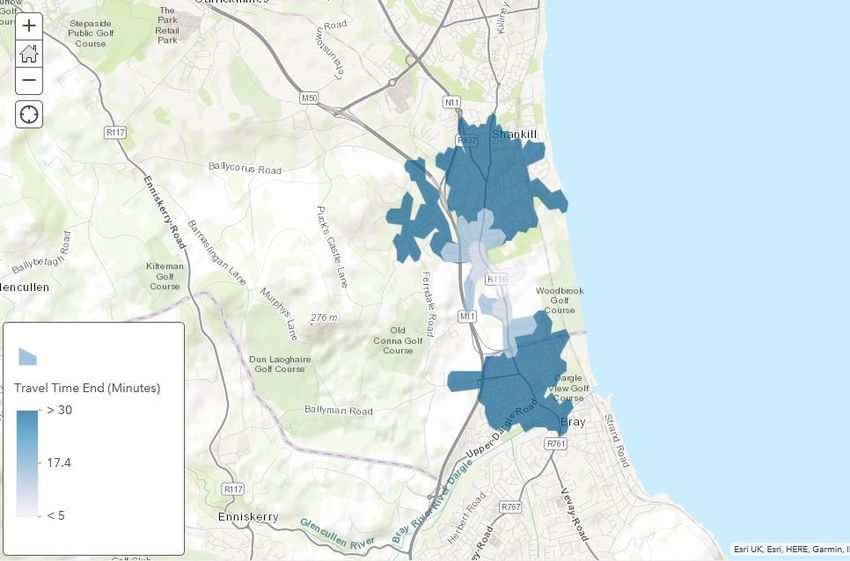
Contents
Chapter                                                                Page
1.      Introduction                                                         4
1.1.    Subject Application                                                  4
1.2.    What is a Mobility Management Plan                                   4
1.3.    Accompanying Documents                                               5
1.4.    Transport Planning Context                                           5
1.5.    Structure of This Document                                           9
2.      Existing Conditions                                                10
2.1.    Subject Site                                                       10
2.2.    Local Land Use                                                     10
2.3.    Local Road Network                                                 10
2.4.    Walking and Cycling Facilities                                     11
2.5.    Public Transport Facilities                                        12
2.6.    Future Transport Proposals                                         13
3.      Objectives and Targets                                             15
3.1.    Objectives and Targets                                             15
3.2.    Mode Share Targets                                                 15
4.      Strategy and Measures                                              16
4.1.    Introduction                                                       16
4.2.    Strategy                                                           16
4.3.    Measures                                                           17
5.      Implementation, Monitoring and Review                              20

Tables
Table 1-1 – GDA Transport Strategy Objectives                               5
Table 1-2 – County Development Plan Policy                                  6
Table 1-3 – LAP Objectives                                                  8
Table 3-1 – Objectives and Targets                                         15

Figures
Figure 1-1 – LAP Movement Strategy                                          9
Figure 2-1 – Site Location                                                 10
Figure 2-2 – Active Travel Isochrones - 30 Minute Walking Isochrones       11
Figure 2-3 – Active Travel Isochrones - 30 Minute Cycling Isochrones       12

5157801DG0008 | 2 | October 2019
Atkins | 5154251dg0057 rev 2.docx                                      Page 3 of 21
1. Introduction
1.1. Subject Application
The Mobility Management Plan (MMP) sets out a strategy designed to promote travel by active and
sustainable modes to the proposed residential development at Woodbrook. This MMP forms part of
a planning application and supports the Traffic and Transportation Assessment.
The planning application is for the proposed residential development at Woodbrook with a total of 685
no. residential units and other uses such as a creche and a temporary rail station car park. A
breakdown is provided as follows.
207 no. Housing units.
48 no. Duplexes units.
430 no. Apartment units.
429 m2 Crèche.
164 no. space Temporary Rail Station Car Park
Provision of 2no. replacement golf holes in lands to the east of the rail line (northeast of the future
DART Station).
A full description of the proposed development is included in the Planning Report and full details of
all pedestrian and cycle connections, road and street layouts, car parking and cycle parking are
contained on the architects, landscape architects and engineering drawings and in the Engineering
Infrastructure Design Report.
The site is subject to LIHAF funding that has been secured by Dun Laoghaire Rathdown County
Council (DLRCC). This LIHAF funding incorporates the road access, Woodbrook Avenue, to the new
DART Station and the upgrade of the existing Wilford roundabout at the junction of the R119 and the
M11 slip roads adjacent Junction 5 of the M11. The design of the roundabout upgrade to traffic
signals is being undertaken by DLRCC and will be delivered under Section 38 of the Road Traffic Act
(1994).
This Outline MMP focuses on the residential element of the proposed Phase 1 development subject
of this application. It is considered that the Creche is not of a scale which would require its own Plan.
However, it should be noted that the Creche will facilitate staff car parking and set-down spaces of
an order which will self-regulate travel demand.
In terms of the neighbourhood centre proposed as part of Phase 2, any requirements in terms of
travel management would be determined as part of the MMP accompanying the future planning
application of phase 2. This will likely build upon this outline MMP and its implementation.
In terms of the proposed school which will likely become operation during the occupation of the future
Phase 2 development, this will be subject to its own MMP which should form part of its future planning
application. This will however be able to avail of the developed strategy and measures associated
with the overall development.
1.2. What is a Mobility Management Plan
A Mobility Management Plan is a strategic management tool designed to accommodate a site’s
specific transportation needs. The MMP aims to educate people regarding how, why and when they
need to travel. It provides a forum to promote and support the use of alternative, active and
sustainable transport modes such as walking, cycling, shared transport and mass transit such as
buses and trains. Consequently, the MMP will also assist in reducing dependency on private car and
mitigate against traffic congestion and its inherent environmental, social and economic impacts.
This document, the Mobility Management Plan (MMP) has been developed with specific reference to
the site location, site context and proposed site layout and, describes the self-regulating management
of travel demand. As such this MMP could help reduce the amount of car travel to and from the
proposed development site at Woodbrook. Not only will this bring benefits to those employed on site
or living within the development but also to the wider local community and environment.
This MMP is not one fixed document but a dynamic and evolving mechanism for introducing and
maintaining a package of measures. These measures focus on promoting access to the site by
5157801DG0008 | 2 | October 2019
Atkins | 5154251dg0057 rev 2.docx Page 4 of 21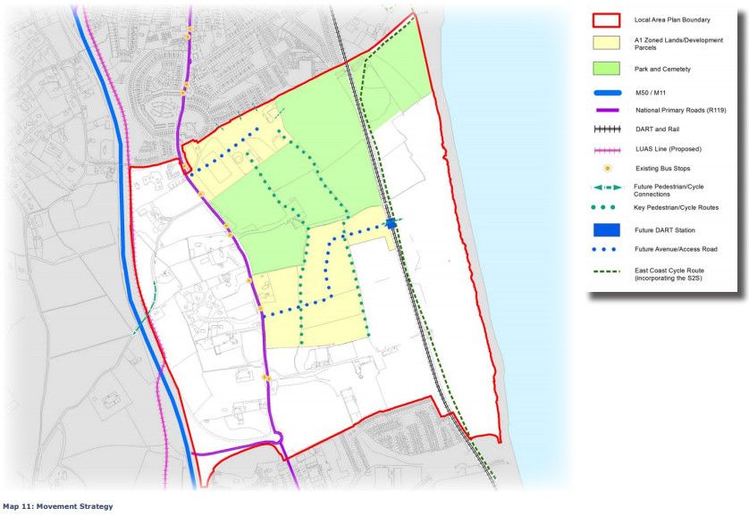
alternative, active and sustainable modes of transport and reducing single occupancy car travel. In
general, the ultimate occupiers will be encouraged to put these measures into practice themselves.

1.3.         Accompanying Documents
An accompanying Traffic and Transport Assessment (TTA) reviews the potential transport impacts of
the proposed development with respect to vehicular traffic and sets out the existing and proposed
public transport, walking, and cycling infrastructure in the area.
In addition, a Quality Audit (Access Audit, Walking and Cycling Audit & Stage 1 Road Safety Audit)
and Design Process Construction Traffic Management Plan accompany the MMP and TTA as part of
the planning application.
This MMP should be read in conjunction with the above documents and all planning, engineering and
architectural reports and drawings.

1.4.         Transport Planning Context
A summary of the key policy documents pertinent to the proposed development and which have
underpinned the proposals and the preparation of this MMP are as follows:

1.4.1.       Smarter Travel
The Smarter Travel Policy, published in February 2009, outlined the Governments vision for achieving
a sustainable transport system for Ireland by 2020. The document outlines a number of key policies
to encourage a modal shift away from private car use and promote alternative travel modes such as
public transport, walking and cycling.
In April 2009 the National Cycle Policy Framework (NCPF) was published. The policy outlined the
vision to develop the appropriate infrastructure to make all cities, towns, villages and rural areas
bicycle friendly and to promote cycling as the normal way to get about, in particular for short trips.
The aim of this framework was to encourage a culture of cycling to the extent that by 2020, some
10% of all trips will be completed by bicycle.
The proposed development incorporates the appropriate measures to enable the vision of both
documents by ensuring the development is fully accessible for all modes, providing good connections
to the existing and planned pedestrian, cycling and public transport links, both within Woodbrook and
on the external transport network.

1.4.2.       Transport Strategy for the Greater Dublin Area 2016 -2035
The Transport Strategy for the Greater Dublin Area (GDA) 2016-2035 established the framework for
transport provision for the city region. This Strategy, which is underpinned by the capital investment
program set out in the National Development Plan 2018-2017, is based on the following over-riding
objective;
“To contribute to the economic, social and cultural progress of the Greater Dublin Area by providing
for the efficient, effective and sustainable movement of people and goods.”
In particular, the Strategy aims to achieve a work commuting modal share target of 55% for
sustainable travel modes, reducing the single occupancy private car modal share to a maximum 45%,
as set out in Smarter Travel Policy.
The Strategy presents infrastructure proposals by mode of transport. Those that will particularly
benefit the proposed development are as follows;

Table 1-1 – GDA Transport Strategy Objectives
 Transport Strategy Objective                 Proposed Site Context
 Additional Rail Stations                           Woodbrook DART Station is located on the
                                                    eastern site boundary
 Core Radial Bus Network                            Existing bus corridor on Dublin Road on western
                                                    site boundary to be upgraded as part of the
                                                    proposed Bus Connects Core Bus Route 13.
 Greater Dublin Area Cycle Network Plan             Primary Route 12A is located on Dublin Road
                                                    along the western site boundary. This route will

5157801DG0008 | 2 | October 2019
Atkins | 5154251dg0057 rev 2.docx                                                          Page 5 of 21
be upgraded as part of the proposed Bus
Connects Core Bus Route 13.
Route 14 /N5, The East Coast Trail, is located
adjacent the eastern site boundary
1.4.3. Bray and Environs Transport Study
In April 2019 the National Transport Authority, in consultation with TII, Wicklow County Council and
Dun Laoghaire Rathdown County Council, published the Bray and Environs Transport Study. The
overarching purpose in undertaking this study was to facilitate the land use objectives of Wicklow
County Council and Dun Laoghaire-Rathdown County Council as provided for in statutory regional,
county and local plans.
The Study is set in the context of the overarching transport objectives set out in the Transport Strategy
for the Greater Dublin Area and sets out more detailed transport requirements to facilitate planned
development sites in the south of Dun Laoghaire Rathdown and the Bray area. These development
sites include Woodbrook and the Study specifically sets out the following requirements to serve the
full build out of lands in Woodbrook / Shanganagh:
Woodbrook DART Station
Commitment to the phased introduction of bus and enhanced rail services in line with
increased demand.
The planning application, including the temporary DART Station car park, fundamentally facilitates
the delivery of the DART Station. Upon delivery of the DART Station the development will avail of
any increases in rail services that will be implemented by the NTA and Irish Rail.
In terms of bus services, the development will have direct access to existing substantive bus services
on Dublin Road immediately adjacent the site. The NTA are planning the implementation of enhanced
bus services on the entire bus network including enhancements to the capacity and efficiency of
services ex Bray DART Station on spine route E1 to the city centre along Dublin Road. The
Development will directly benefit from these planned improvements. The development will also
facilitate and directly benefit from the proposed Bus Connects Core Bus Route 13 which will serve to
optimise the efficient operation of bus services along this route.
1.4.4. Dun Laoghaire Rathdown County Development Plan 2016-2022
The Dun Laoghaire Rathdown County Development Plan 2016-2022 contains specific policies in
terms of sustainable travel and transportation. The proposed development, by virtue of its location,
scale and typology is consistent with both the strategic sustainable transportation policies of the Plan
and the specific transportation objectives. In terms of overall policy, The Council
“…recognises that the current trends in transportation, in particular the domination of the private car
as the preferred mode choice, are unsustainable……. In response, the emphasis must be on
developing an efficient transport network where an increased proportion of residents of the County
are within reasonable walking/cycling distance of local services and quality public transport
infrastructure. There must also be a focus on promoting and facilitating the optimum use of existing
(and proposed) transport services”
Listed below are the key relevant sustainable transport policies of the County Development Plan
together with a summary of the corresponding characteristics of the proposed development that
facilitate the delivery of these policies. It is to be noted that the Transport Strategy for the Greater
Dublin Area was in draft format when the County Development Plan was adopted.
Table 1-2 – County Development Plan Policy
Reference Policies/Objectives Development Context
Policy ST1: “It is Council policy to actively Woodbrook DART Station is located on the
Integration of support sustainable modes of eastern site boundary. The adjacent park &
Land Use and transport and ensure that land ride car park contains bus stop facilities to
Transportation use and zoning are fully facilitate bus to rail interchange.
Policies integrated with the provision and
5157801DG0008 | 2 | October 2019
Atkins | 5154251dg0057 rev 2.docx Page 6 of 21Reference Policies/Objectives Development Context
development of high quality The site is located adjacent the Dublin Road
public transportation systems.” bus corridor that will be upgraded as Bus
Connects Core Bus Route 13.
The entire site is within 800m walking
distance of the Woodbrook DART Station
and Dublin Road bus corridor.
Policy ST2: “It is Council policy to promote, The proposed development specifically
Development facilitate and cooperate with other facilitates the development of Woodbrook
of Sustainable transport agencies in securing the DART Station through the provision of
Travel and implementation of the Woodbrook Avenue, the main access route,
Transportation transportation strategy for the together with the temporary park and ride car
Policies County and the wider Dublin park.
Region as set out in Department
of Transport’s ‘Smarter Travel, A The site facilitates the upgrade of the Dublin
Sustainable Transport Future Road bus corridor per the NTA plans for Bus
2009 –2020’ and the NTA’s Connects Core Bus Route 13.
‘Greater Dublin Area Draft
Transport Strategy 2011‐2030’.
Policy ST4: “It is Council Policy to secure the The development is adjacent and accessible
Walking and development of a high-quality to Routes 12A and 14 / N5 Greater Dublin
Cycling walking and cycling network Area Cycle Network Plan
across the County in accordance
with relevant Council and The development incorporates extensive
National policy and guidelines.” pedestrian and cycle routes that link the site
to the Dublin Road on the western boundary,
Shanganagh Park on the northern boundary,
Woodbrook DART Station on the eastern
boundary and facilitation for future
connections across the southern site
boundary.
Policy ST19: “It is Council policy, in conjunction The site is planned in the context of a Mobility
Travel and co-operation with other Management Plan based on the physical
Demand agencies, to implement Travel infrastructure provisions of walking and
Management Demand Management measures cycling links and access to public transport
aimed at reducing the demand for bus and DART rail services.
travel and increasing the
efficiency of the transport network Demand Management is also underpinned
with due consideration given to by the co-location of residential, education,
the effect of parking controls on local retail and leisure and amenity facilities.
nearby residential roads.”
The propensity for car ownership and car use
is managed through measures that include
reduced residential parking provision and
increased cycle parking provision in line the
‘Design Standards for New Apartments’. The
provision of car club parking spaces will
facilitate a lower level of car ownership.
Policy ST21: “It is Council policy to support the The development contains the required
Electric Government’s Electric Transport infrastructure to facilitate electric charging to
Vehicles Programme by facilitating the all car parking spaces.
rollout of Electric Powered
Vehicle Recharging Parking Bays
for electric vehicles across the
County through the planning
system and on public roads.”
5157801DG0008 | 2 | October 2019
Atkins | 5154251dg0057 rev 2.docx Page 7 of 211.4.5. Woodbrook / Shanganagh LAP 2017-2023
The Local Area Plan contains specific objectives relating to sustainable movement and transport. In
overall terms Policy WS4 of the LAP sets out the Councils policy in relation to sustainable transport
provision as follows:
“To promote sustainable transport forms such as walking, cycling and public transport as set out in
the Government’s ‘Smarter Travel – A Sustainable Transport Future 2009-2020’ and to support
planned infrastructure that prioritises public transport, as well as new cycling and pedestrian
interconnections to key public transport nodes, school and amenity destinations in the Woodbrook-
Shanganagh LAP Area and wider environs.”
The LAP sets out sixteen objectives relating to sustainable travel which are summarised below. Based
on the development proposals set out in the TTA and shown in further detail on the architectural,
landscape architectural and engineering drawings and report, it is concluded that the development,
where relevant, facilitates the delivery of all these objectives:
Table 1-3 – LAP Objectives
Objective Summary
T1 To promote sustainable transport forms such as walking, cycling and public transport
as set out in Smarter Travel
T2 To promote the provision of a DART Station at Woodbrook as set out in the National
Transport Authority’s (NTA) ‘Transport Strategy for the Greater Dublin Area 2016-
2035’
T3 To seek early delivery of the planned DART Station
T4 To provide for a public transport interchange between Suburban Rail (DART) and the
Quality Bus Network (QBN) at the planned Woodbrook DART Station
T5 To provide for a temporary car park to accommodate up to 150-200 Car Parking
Spaces in the immediate vicinity of the planned DART Station at Woodbrook
T6 To support the delivery of a Strategic Park and Ride facility within the Plan Area in
accordance with the objectives of the NTA’s Transport Strategy for the Greater Dublin
Area 2016-2035
T7 To co-operate with the National Transport Authority, Transport Infrastructure Ireland
and Wicklow County Council in relation to the Dublin Road Core Bus Corridor
T8 To seek to retain the sylvan character of the Dublin Road in any road improvement
schemes
T9 To provide for a high quality pedestrian and cycle network within the LAP Area with
high levels of permeability, passive surveillance and supervision that will provide
attractive, legible and direct links to the Neighbourhood Centre, the DART Station, Bus
Stops, Shanganagh Park and the wider area outside the Plan Boundary.
T10 To ensure that all proposals for new roads, streets and residential layouts comply with
the ‘Design Manual for Urban Roads and Streets’ (DMURS, 2013) which focuses on
the needs of pedestrians, cyclists and public transport users.
T11 To provide for safe and secure cycle parking at appropriate locations within the LAP
Area and in particular close to recreational or community facilities, residential units,
transport nodes, shops and services
T12 To provide pedestrian / cycle access across the M11 Corridor at Allies River Road
T13 To promote the development of the National East Coast Trail Cycle Route
T14 To adopt a proactive mobility management approach and to encourage a culture of
sustainable travel in the new residential neighbourhoods at Woodbrook-Shanganagh
T15 To support the set-up of Car Club Schemes in accordance with Policy ST23 of the
County Development Plan 2016- 2022
T16 To promote and provide for any future Luas Extension (Luas Line B2)
5157801DG0008 | 2 | October 2019
Atkins | 5154251dg0057 rev 2.docx Page 8 of 21These objectives are encapsulated in “Map 11: Movement Strategy” which is reproduced below.
Figure 1-1 – LAP Movement Strategy
This map illustrates the key transport infrastructure provisions and links that are facilitated and
accommodated by the proposed development. These include:
Woodbrook DART Station
Proximity to the R119 Dublin Road bus corridor and cycle route
Woobrook Avenue, facilitating walking, cycling and vehicular access through the site from the
R119 Dublin Road to the DART Station and park and ride car park.
Pedestrian and cycle links linking the development to Shanganagh Park to the north and
potential linkages to the south.
Proximity and access to the East Coast Cycle Trail
1.5. Structure of This Document
The MMP report provides the basis for the implementation of the MMP. It sets out the objectives and
measures to be put in place. Provisionally the MMP Report will be set out using the sections described
below:
Section 2 sets out the Existing Conditions in terms of local accessibility.
Section 3 establishes Objectives and Targets for the MMP.
Section 4 outlines the broad Strategy and Measures for the MMP.
Section 5 outlines the process for Implementation, Monitoring and Review.
5157801DG0008 | 2 | October 2019
Atkins | 5154251dg0057 rev 2.docx Page 9 of 212. Existing Conditions
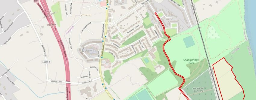
2.1. Subject Site
The proposed development site comprises of lands to be served by the new Woodbrook DART
Station within the Woodbrook Shanganagh Local Area Plan (LAP). The site location is as shown
below. The development site will be served by a vehicular junction onto the Dublin Road, adjacent
the existing Woodbrook Downs junction.
The location of the site is shown in the Figure below.
Golf Course
Holes Site
Extents
Phase 1 Site
Extents
Figure 2-1 – Site Location
2.2. Local Land Use
Land uses in vicinity of the proposed development site are mainly residential. Directly adjacent to the
site, Shanganagh Cemetery and Shanganagh Park border its northern perimeter. To the east of the
proposed development it is bordered by Woodbrook Golf Club, to its south it is bordered by the access
road to the Woodbrook Golf Club and amenity grassland. The proposed development site is bordered
to its west by the R119 Dublin Road.
In a wider context, significant population areas lie directly north and south of the proposed
development site namely Shankill and Bray respectively. Both of these location also offer
employment and commercial land uses normally associated with a village and town centre
respectively.
2.3. Local Road Network
The proposed development site is located adjacent to a comprehensive road network consisting of
national roads, motorways, regional roads and local roads. The key roads within this road network
are described in detail in the accompanying TTA and are summarised below:
5157801DG0008 | 2 | October 2019
Atkins | 5154251dg0057 rev 2.docx Page 10 of 21 The proposed development will access onto the R119 Dublin Road. The R119 Dublin Road is a
single carriageway regional road with cycle lanes and bus lane provision provided along some
sections of the route. In the vicinity of the development access junction the R119 is a single
carriageway regional road with cycle lanes on both sides.
To the south the R119 Dublin Road provides access to town centre of Bray, via the R761, and
the M11 via the Wilford Interchange facilitating access to the M50 to the north & M11 to the south.
To the north the R119 Dublin Road connects through Shankill Village to the R837 facilitating
access the N11 and thereby Cabinteely, Stillorgan, UCD and Donnybrook. Access is also
provided to the north to Killiney, Dalkey, Sandycove and Dun Laoghaire, along the R119
Shanganagh Road.
A full description of the local road network is contained within the TTA.
2.4. Walking and Cycling Facilities
2.4.1. Walking and Cycling Provision
Footpath provision in general is adequate on surrounding roads with most offering footpaths of ample
width on both sides of the carriageway. The R119 Dublin Road to which the proposed development
directly gains access provides footpaths of adequate width on both sides of the road. Crossing
facilities are generally uncontrolled with some controlled pelican crossings provided at certain
locations.
Nominal width advisory cycle lanes are also offered on both sides of the road, however existing
cycling facilities are below current standards and lack continuity and connectivity.
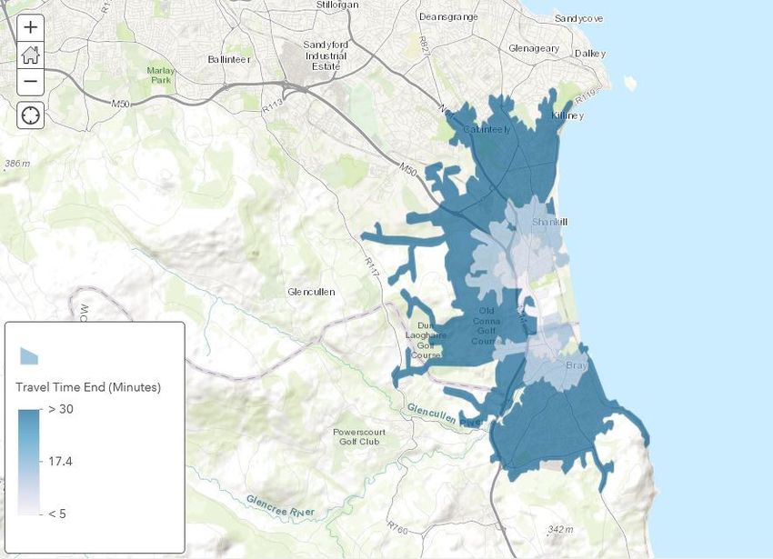
2.4.2. Walking and Cycling Isochrones
An analysis of the walking and cycling catchments in terms of journey distance and time has been
undertaken and the results of this are presented below. These are represented in the form of
isochrones radiating outwards from the proposed development site in 5 minute journey time intervals.
In terms of walking Shankill Village Centre and Shankill Train Station are accessible within 30
minutes, as is the northern extents of Bray Town Centre as detailed in Figure 2-2 below.
Phase 1 Site
Location
Figure 2-2 – Active Travel Isochrones - 30 Minute Walking Isochrones
5157801DG0008 | 2 | October 2019
Atkins | 5154251dg0057 rev 2.docx Page 11 of 21In terms of cycling, this catchment is extended further including Cabinteely & Killiney to the north and
the southern extents of Bray Town Centre and Bray DART Station as detailed in Figure 2-3 below.
Phase 1 Site
Location
Figure 2-3 – Active Travel Isochrones - 30 Minute Cycling Isochrones
2.5. Public Transport Facilities
There are a number of existing public transport facilities available in vicinity of the proposed
development site ranging from bus services to rail services. The Figure provided below illustrates
these in the local context.
2.5.1. Bus Routes and Services
It is considered that the proposed development is well located, granting opportunity to access both
services and employment opportunities in the local and wider environs via public transport. The
available bus services are as follows.
Route 84 – Newcastle to Blackrock.
Route 84a – Bray to Blackrock.
Route 145 – Heuston Rail station to Ballywaltrim.
Route 155 – Ikea (Ballymun) to Bray Rail Station.
In a wider context there are also significant sustainable accessibility opportunities for commuter
access to employment and education destinations in Dublin City.
2.5.2. DART Rail Services
In terms of heavy rail, the closest stations are Shankill circa 2.5km to the north and Bray also circa
2.5km to the south. Both stations serve both DART and Commuter Rail services. These stations
facilitate services that allow for good connection to other onward destination both north and south.
Services generally operate with 10-minute frequencies during the peak hour morning and evening
commuter periods. The future Woodbrook DART station adjacent the development will make these
services conveniently accessible to future residents.
5157801DG0008 | 2 | October 2019
Atkins | 5154251dg0057 rev 2.docx Page 12 of 212.6. Future Transport Proposals
The Transport Strategy for the Greater Dublin Area (GDA) 2016-2035 sets out how transport and its
associated infrastructure will be developed across the GDA region up to the year 2035. The following
key transport proposals are specifically relevant to the proposed development.
2.6.1. BusConnects
Bus Connects is the further development of the bus services as set out in the Transport Strategy.
This project is currently being progressed by the NTA to implement both network and bus corridor
improvements to overhaul the current bus system in Dublin. These initiatives consist of the following
key elements of relevance to the proposed development.
Core Bus Corridor Project
The Core Bus Corridor Project is identified in the GDA Transport Strategy. In November 2018
the NTA commenced the public consultation the radial corridors. The public consultation process
was broken into three phases with Route 13 from Bray to City Centre being included in Phase 3.
This went to public consultation on 28th February 2019. This public consultation process ended
on the 31st May 2019.
The Applicant has liaised directly with the NTA on Route 13. Consultation was undertaken in
terms of ensuring the proposed development access junction on the Dublin Road would not
prejudice the delivery of the bus corridor. In order to confirm this the applicant prepared a
proposed junction layout that would incorporate and upgrade of the proposed development
junction in order to incorporate the bus corridor route proposals as set out in the public
consultation. The NTA has confirmed these proposals are appropriate and would facilitate Bus
Connects.
Bus Network Redesign
The existing bus network is undergoing a redesign to accommodate the growth of Dublin City.
This redesign will also reduce the complexity of the network. As currently proposed, the redesign
in Bray, Enniskerry and Shankill aims to replace a complex network of overlapping routes with a
simpler network. Direct services to the city centre will be provided ex Bray DART Station via
Dublin road, adjacent the proposed development, on spine route E1. Services will operate at least
every ten minutes frequency in the peak hour.
2.6.2. Cycle Network
The Greater Dublin Area Cycle Network Plan proposes to expand the urban cycle network to over
1,485 kilometres in length and will provide over 1,300 kilometres of new connections between towns
in the rural areas of the GDA. The network is intended to provide a quality of service sufficient to
attract new cyclists, as well as catering for the increasing numbers of existing cyclists. The proposed
routes of relevance to the proposed development are as follows;
Primary Route 12 / 12A – Bray to City Centre. This route extends from Bray to the City Centre
via Woodbrook and traverses the R119, the R837, the N11 and the R138.
Greenway Route 14 / W11 / N5 – Wicklow Town to Dublin City Centre. This route forms part of
the southern East Coast Trail. In vicinity of the proposed development the route will extend from
Bray to Dún Laoghaire onwards.
2.6.3. Proposed DART Station and Temporary Car Park
The Transport Strategy outlines the need for a number of additional stations to be added to the
network in developing areas which have a sufficient level of demand to support the provision of a train
station. This includes specifically for Woodbrook on the South-Eastern DART Line.
Thus, the proposed development facilitates the development of a new DART Station on the
masterplan lands. This station is being delivered by the NTA and Irish Rail. It has been agreed with
the NTA and DLRCC that the station will be completed in tandem with the completion of the subject
Phase 1 proposed development. The design of the station, to be fully integrated to the proposed
development site, has been the subject of direct consultations between Irish Rail, the NTA, DLRCC
and the Applicant.
The proposed development includes for the provision of a 164 no. space temporary station car park
to be delivered in Phase 1 via the completion of Woodbrook Avenue, the main spine route through
5157801DG0008 | 2 | October 2019
Atkins | 5154251dg0057 rev 2.docx Page 13 of 21the site from the Dublin Road. Irish Rail has commenced design work on the station with a view to lodging a planning application in the final quarter of 2019. The Transport Strategy outlines the objective to develop a strategic park and ride site in the Woodbrook area. The strategic site will be developed by the NTA on a site yet to be determined. At that time the temporary park and ride will be subsumed as residential development within the Woodbrook site. 5157801DG0008 | 2 | October 2019 Atkins | 5154251dg0057 rev 2.docx Page 14 of 21
3. Objectives and Targets
3.1. Objectives and Targets
The objectives of the Mobility Management Plan Travel Plan are set with the overall aim of reducing
the number of single occupancy car trips associated with the residential elements of the development.
The objectives of the Woodbrook Outline Mobility Management Plan are as follows:
Achieve a high level of Community Awareness of the MMP.
Ensure a high level of Community Participation in the development of the travel surveys to
indicate participation.
Improve conditions for pedestrians and cyclists travelling to and from the site.
Develop on good urban design principles to enhance the permeability of the site and maximise
accessibility by sustainable modes.
Encourage the development of a healthy, sustainable and vibrant local community through
promotion of travel by sustainable modes.
The following Table outlines tangible targets to be achieved in relation to the key objectives.
Table 3-1 – Objectives and Targets
Objectives Residential Travel Plan Targets
Awareness To provide information on sustainable travel to each resident
upon occupation.
Participation To develop a detailed residential travel plan within 9 months of
first occupation.
Accessibility measures implemented to encourage walking, cycling, public
transport and car sharing from first occupation.
Maximise the Potential for To promote and encourage physical measures implemented as
Sustainable Travel part of the site layout to encourage sustainable modes of travel
from first occupation.
Reduce Car Related Travel To identify mode Share Targets to be agreed with Dun
Laoghaire Rathdown County Council following travel surveys.
3.2. Mode Share Targets
It is anticipated that mode share targets will be agreed with Dún Laoghaire-Rathdown County Council,
following an initial travel survey to be undertaken following occupation of the site. Targets identified
will be set against the existing mode share established from the survey.
A timeframe will be set within which the targets should be achieved; however, the plan will be a lifelong
document evolving with the development of the site and addressing any changes in travel behaviour.
5157801DG0008 | 2 | October 2019
Atkins | 5154251dg0057 rev 2.docx Page 15 of 214. Strategy and Measures
4.1. Introduction
This section of the MMP sets out the Strategy and Measures proposed for the residential development
at Woodbrook.
Clearly, as the users of the development are currently unknown at this stage the MMP can only
commit to promoting alternatives and providing the means for active and sustainable travel choices
to be made.
The use of good urban design principles allows active and sustainable travel modes to be prioritised,
where appropriate, through the physical layout of the site. This leads the adoption of more sustainable
modes for travel. The MMP will develop on the physical interventions of the development proposals
for the site layout. The physical interventions will be supported, and active and sustainable modal
shift encouraged through the development of ‘softer’ measures.
This section describes the services to be provided and the ‘in built’ infrastructure measures (as part
of the layout and design of the development) which are intended to encourage use of active and
sustainable travel modes and complement the strategic aspects of the MMP.
The complementary measures will address the objectives, as set out in Section 3. These are to be
delivered through a co-ordinated strategy delivered by the Management Company and involving the
distribution of Travel Information Packs.
4.2. Strategy
Travel Information Packs will form part of the marketing material for the site and will be distributed
to all new residents within the development at point of sale. These will be distributed by the
Management Company. The details of the Travel Information Packs would be provided to Dún
Laoghaire-Rathdown County Council (DLRCC). The Travel Information Packs would ideally contain
the following information:
Information about public transport, walking and cycling routes and car parking management.
Information about local services and facilities that are within comfortable walking distance.
Information on active and sustainable transport measures facilitated by the development (i.e.
bicycle parking, car sharing scheme, EV charging, etc.).
Information on future transport infrastructure.
Through a monitoring and review process, the Management Company will also be responsible for
ensuring that the measures proposed are implemented in the most effective way possible.
5157801DG0008 | 2 | October 2019
Atkins | 5154251dg0057 rev 2.docx Page 16 of 214.3. Measures
The following measures should be promoted to encourage the best choice of travel other than private
car use.
4.3.1. Walking
There are many local, global, and personal benefits to walking, a few are listed following:
W - Wake Up! - Studies have shown that individuals who walk to work, school or elsewhere are
more awake and find it easier to concentrate.
A - Always one step ahead - Walking makes people more aware of road safety issues and
helps them develop stronger personal safety skills.
L - Less congestion - If you leave the car at home and walk, there are fewer cars on the road
which makes it safer for those who walk and cycle.
K - Kinder to the environment - By leaving the car at home you are reducing the amount of CO2
produced and helping to reduce the effects of climate change and air pollution.
I - Interpersonal skills - Walking can be a great way to meet other walkers, share the
experience, and develop personal skills.
N - New adventures - Walking is a great way to learn about your local environment and
community. It’s also a fun way to learn about the weather, landscape, and local ecosystems.
G - Get fit and stay active - Walking helps people incorporate physical activity into their
daily routines. Research shows that regular physical activity can benefit your body and mind.
Walking has the capacity to replace car based journeys of up to 3.5km. A high proportion of walking
journeys may form the start or end of larger journeys comprising of bus or rail links, hence an attractive
walking experience can play a large part in encouraging public transport patronage.
The site offers distinct opportunities, both within the existing environment and as part of the future
transport provisions in terms of facilitating extensive volumes of local trip making on foot, including
access to public transport services.
4.3.2. Cycling
Research indicates that cycling is a viable mode of transport for residents wishing to undertake
journeys of up to 10km. Some positive aspects of cycling are listed following:
C - Cycling is a life skill - Cycling is a sustainable way of travelling but it’s also a great
recreational activity. Cycling is a skill that stays with you for life and it’s a fantastic way to
explore your local community.
Y - You save time & money - cycling reduces the need to travel by car thus reducing fuel costs
and freeing up road space for more cyclists;
C - Confidence building - travelling as an independent cyclist can give people increased
confidence proving beneficial in all aspects of life;
L - Less congestion - If you leave the car at home and cycle, there are fewer cars on the road
which makes it safer for other cyclists;
I - Interpersonal skills - Cycling can be a great way to meet other cyclists and share the
experience;
N - New adventures - Cycling is a great way to learn about your local environment and
community. It helps residents to understand where they live and how their actions affect their
local environment;
G - Get fit and stay active - cycling helps people incorporate physical activity into their daily
routines. Research shows that regular physical activity can benefit your body and mind.
The provision of cycle routes and facilities at the site will play a critical role in attracting residents to
cycle to work, school, or elsewhere.
The following initiatives and incentives will encourage cycling within the development and within the
wider LAP lands and have the potential to set the LAP as an exemplar for sustainable local travel:
5157801DG0008 | 2 | October 2019
Atkins | 5154251dg0057 rev 2.docx Page 17 of 21 Provide cycle parking, ideally located centrally, secure, and well lit;
Provide cycle parking for visitors and publicise in welcome Travel Information Packs;
Publicise the Government Bike to Work Scheme (www.biketowork.ie) in welcome travel packs;
Provide information on walking and cycling distance, routes and journey times by bike or
walking to key destinations in welcome travel packs for residents.
Highlight the direct savings gained due to reduced use of private vehicles in welcome travel
packs;
Publicise National Bike Week in welcome travel packs, see www.bikeweek.ie.
4.3.3. Public Transport
There are many benefits to taking public transport, some of which include:
Personal Opportunities – Public transportation provides personal mobility and freedom;
Saving fuel – Every full standard bus can take more than 50 cars off the road, resulting in fuel
savings from reduced congestion;
Reducing congestion – The more people who travel on public transport, especially during peak
periods, the less people travelling by private car;
Saving money – Taking public transport is a lot cheaper than travelling by car and saves the
cost of buying, maintaining and running a vehicle;
Reducing fuel consumption – A full standard bus uses significantly less fuel per passenger than
the average car;
Reducing carbon footprint – Public transport is at least twice as energy efficient as private cars.
Buses produce less than half the CO2 emissions per passenger kilometre compared to cars
and a full bus produces 377 times less carbon monoxide than a full car;
Get fit and stay active - Walking to and from public transport helps residents incorporate
physical activity into their daily routines. Research shows that regular physical activity can
benefit your body and mind.
Less stress – Using public transport can be less stressful than driving, allowing time to relax,
read, or listen to music.
The following initiatives and incentives can be used to encourage residents to take public transport:
Encourage public transport use by publicising the benefits of smart cards to all residents in
welcome Travel Information Packs;
Publicise the availability of Real Time Information on the Bus Service Providers website and
Bus Service Providers mobile app in welcome travel packs. Real Time Information shows when
your bus is due to arrive at your bus stop so you can plan your journey more accurately;
Publicise the availability of a National Journey Planner, which provides journey planning,
timetable, and travel information from all licenced public transport providers across Ireland, in
welcome travel packs. This Journey Planner is available on the Transport for Ireland website
and as a mobile app;
Provide maps in welcome travel packs of local bus routes and the nearest bus stops, and the
length of time it takes to walk to them;
Promote Tax Saver Commuter tickets, which offer significant savings to individuals in marginal tax
rate and levies on the price of their ticket, in welcome travel packs;
5157801DG0008 | 2 | October 2019
Atkins | 5154251dg0057 rev 2.docx Page 18 of 214.3.4. Car Sharing Scheme
There are many user benefits to access to a car sharing scheme over ownership of a private car,
some of which include:
One time sign up, no big investment.
Membership fee covers insurance, fuel, free parking in Dublin city Centre, maintenance, motor
tax and NCT.
Benefits which the built environment can avail of include:
Reduced emissions and pollution.
Reduced traffic congestion.
Reduced car parking requirements.
Complements and supports the uptake of all active and sustainable travel modes.
As part of the Developers initiative to provide alternative transport solutions, it is proposed to
provide 4 no. car sharing (GoCar) spaces within the proposed Phase 1 development. Based on the
uptake of the scheme there is potential to provide additional car sharing spaces. In overall terms car
sharing spaces can replace up to 15 no. traditional car parking spaces. A letter of intent is provided
in Appendix H of the TTA from GoCar, confirming the provision of 4 shared car club vehicles in
Phase 1 and consideration of adding 4 further vehicle spaces as part of Phase 2 of the
development.
5157801DG0008 | 2 | October 2019
Atkins | 5154251dg0057 rev 2.docx Page 19 of 215. Implementation, Monitoring and
Review
The MMP strategy and measures outlined will be implemented over a period of time which will be
continuously monitored to ensure the MMP continues to deliver on its objectives and targets.
A key aspect of the MMP is the provision of Travel Information Packs for staff and residents of the
mixed use development. This will be undertaken by the Management Company.
Monitoring of the MMP will be important in understanding the changing nature of staff and resident
travel habits and the effectiveness of the MMP initiatives. The monitoring process, which will be
carried out by the Management Company, will involve annual travel surveys undertaken, starting one
year from the initial post occupation travel surveys to assess changes to the mode share of trips to
the development site over a three year period. This will have particular focus on the level of usage
of the bicycle parking and the uptake the car sharing scheme to determine whether and when
additional spaces are required.
An annual monitoring report would be produced for the site by the Management Company, setting
out the results of the travel surveys and highlighting any issues arising from the review of the MMP
initiatives. The report would set out appropriate changes to existing initiatives if required in order to
meet the MMP objectives.
5157801DG0008 | 2 | October 2019
Atkins | 5154251dg0057 rev 2.docx Page 20 of 21Traffic & Transport Department WS Atkins International Limited Atkins House 150 Airside Business Park Swords Co. Dublin Tel: +353 1 810 8000 Fax: +353 1 810 8001 © WS Atkins International Limited except where stated otherwise 5157801DG0008 | 2 | October 2019 Atkins | 5154251dg0057 rev 2.docx Page 21 of 21
You can also read