Traffic Management Strategy - FIFTH STREET BRIDGE REHABILITATION DRAFT Report - City of Courtenay
←
→
Page content transcription
If your browser does not render page correctly, please read the page content below
FIFTH STREET BRIDGE REHABILITATION
Traffic Management Strategy
            DRAFT Report

                                                  Prepared for
                                       The City of Courtenay

                                                  July 2020

                                                       File no.
                                                  3222.0045.02
Contents
Executive Summary....................................................................................................................................... 1
        General Purpose Traffic ..................................................................................................................................................2
        Priority Vehicles ...................................................................................................................................................................3
        Commercial Vehicles/Oversize Vehicles ............................................................................................................. 4
        Pedestrians and Cyclists ............................................................................................................................................... 4
        Park Access ............................................................................................................................................................................ 4
        Transportation Demand Management................................................................................................................7
1.0     Overview ................................................................................................................................................ 8
        1.1 Purpose ............................................................................................................................................................................ 8
        1.2 Key Characteristics ................................................................................................................................................... 9
2.0     Construction Parameters ................................................................................................................ 10
3.0     Community Input ................................................................................................................................ 11
        3.1 Methods ........................................................................................................................................................................... 11
        3.2 Feedback Received .................................................................................................................................................. 11
4.0     Traffic Conditions - No Construction ........................................................................................... 12
        4.1 Daily Traffic Profile at the Bridges ................................................................................................................. 12
        4.2 Typical Traffic Condition .......................................................................................................................................14
        4.3 Travel Pattern (Origin + Destination) ........................................................................................................... 16
        4.4 Travel Time .................................................................................................................................................................... 17
5.0     Traffic Conditions - During Construction .................................................................................. 19
        5.1 Scenario 1: Single Lane Alternating..............................................................................................................20
        5.2 Scenario 2: Westbound Only Open..............................................................................................................20
        5.3 Scenario 3: Eastbound Only Open ................................................................................................................20
        5.4 Scenario 4: Mid-day Direction Change....................................................................................................... 21
        5.5 Summary and Recommendation .................................................................................................................. 21
6.0     Traffic Management ........................................................................................................................... 23
        6.1 Queue Storage Location Comparison (General Purpose Traffic) ............................................. 25
        6.2 Priority Vehicles ........................................................................................................................................................ 29
        6.3 Pedestrians and Cyclists ..................................................................................................................................... 33
        6.4 Traffic Control Methods .......................................................................................................................................34
        6.5 Intersection Modifications ................................................................................................................................. 36
        6.6 Signal Optimization ............................................................................................................................................... 36
        6.7 Travel Time Forecast..............................................................................................................................................42
7.0     Transportation Demand Management ...................................................................................... 46
        7.1 Mode Shift ................................................................................................................................................................... 46
        7.2 Time-of-Day Travel ................................................................................................................................................. 49
8.0     Communications ............................................................................................................................... 50

FIFTH STREET REHABILITATION TRAFFIC MANAGEMENT STRATEGY – DRAFT REPORT
City of Courtenay | July 2020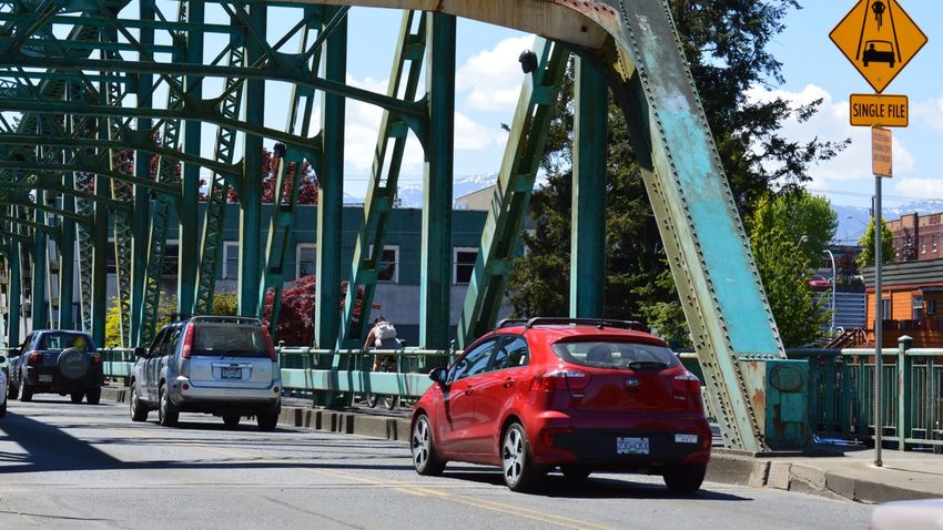
Executive Summary
The City of Courtenay is currently preparing for the proposed upgrades to the Fifth Street
Bridge which is planned for the Spring and Summer of 2021. The Fifth Street Bridge
rehabilitation works require reducing the bridge to a single travel lane for vehicles plus a
sidewalk/pathway for pedestrians and cyclists. The work timeline is anticipated to take up to
six months.
The Traffic Management Strategy for the Fifth Street Bridge Rehabilitation has been
prepared to identify and evaluate various traffic management scenarios and develop a
recommended strategy. The goal of this strategy is to provide a safe environment for all road
users during the construction phase while minimizing impacts to the public, businesses, and
priority vehicles (transit, emergency services, etc.). The recommendations are intended to be
used by the City to communicate both internally and externally as well as forming the basis
of the contractor’s Traffic Management Plan.
The recommendations in this report are based on the anticipated construction approach and
resulting traffic management requirements. However, the recommendations in this Traffic
Management Strategy will likely be refined in conjunction with the successful contractor and
implementation will be subject to the contractor’s work plan and the available budget.
Courtenay residents and various stakeholders and organizations were engaged early in the
development of this traffic management strategy. Extensive feedback was considered to
understand the community’s needs and identify potential mitigation options. The most
important considerations identified through stakeholder consultations were:
Reducing congestion and maintaining access for all modes is the highest
priority.
Adjustments in travel behaviors are expected and are most likely to include
taking an alternate route, planning for additional travel time, and travelling
outside peak periods (limited support was shown for taking the bus and
carpooling).
Maintaining access for emergency services and public transit are important
considerations.
Technical analysis of single lane traffic during pre-construction conditions and during
construction conditions was completed, and four options were developed: eastbound traffic
only, westbound traffic only, single lane alternating traffic, and mid-day direction change.
The analysis concluded that single lane alternating is the preferred method for managing
traffic during the construction phase. In comparison to the other three options, single lane
FIFTH STREET REHABILITATION TRAFFIC MANAGEMENT STRATEGY – DRAFT REPORT 1
City of Courtenay | July 2020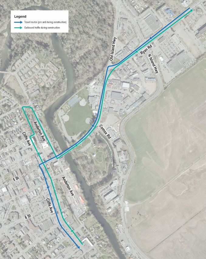
alternating allows residents and commuters similar access to what they currently enjoy,
albeit maybe more slowly. It also provides continued access to and from the downtown.
Additionally, single lane will provide more balanced network performance at bridges as well
as highways and municipal roads and is most responsive to the concerns identified by the
public and stakeholders.
The recommended traffic management strategy is illustrated in Figure E-1 and described as
follows.
General Purpose Traffic
Leaving Downtown
General purpose traffic will be directed to access the bridge via a detour route
involving travelling northbound on Cliffe Avenue, right on 3rd Street, left into
the laneway between Cliffe Avenue and Anderton Avenue, right on 1st Street
and finally right onto Anderton Avenue.
This detour will minimize impacts to business and provide storage for most of
the traffic queues on Anderton Avenue instead of 5th Street.
Use of the laneway between Cliffe Avenue and Anderton Avenue for bridge
traffic is recommended since the laneway has minimal direct accesses and its
use would minimize the impact of queues on the residents on Cliffe Avenue
between 3rd Street and 1st Street 1.
On Anderton Avenue, parking on the west side can be re-allocated for queue
storage. This would enable 2-way free flow traffic to be maintained for access
to destinations on Anderton Avenue, such as the Filberg Centre. This lane
would also act as a priority lane for transit leaving downtown.
On 1st Street, there appears to be sufficient room to accommodate a queue
lane on the right side while maintaining two-way traffic. This will enable access
to the Condensory Bridge and destinations on Anderton Avenue to be
maintained.
Traffic control personnel may be required to help manage the queue,
especially during the initial phase of the construction.
To facilitate general traffic detour 5th Street eastbound (towards the bridge)
will be closed at Cliffe Avenue except for local traffic and Anderton Avenue will
be closed at 6th Street except for local traffic and large trucks.
1
As an alternative to using the laneway, traffic could be directed to continue on Cliffe Avenue to 1st Street. This can be
considered further at future stages of the Traffic Management Plan Development with consideration of the trade-
offs of potential impacts to residents versus a higher volume of traffic utilizing the laneway.
FIFTH STREET REHABILITATION TRAFFIC MANAGEMENT STRATEGY – DRAFT REPORT 2
City of Courtenay | July 2020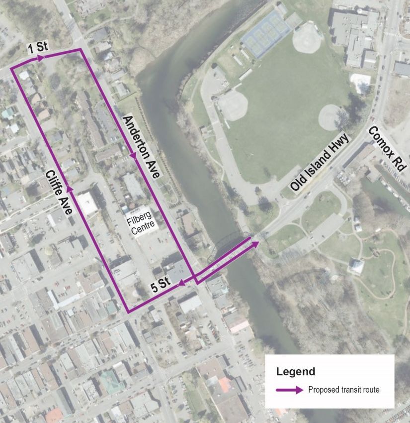
Entering Downtown
No significant changes to current traffic patterns for general purpose traffic
have been identified. There are changes required for access to the park that
are discussed below.
Priority Vehicles
Priority vehicles include transit, emergency services, school buses, and potentially car-pool or
high occupancy vehicles.
Entering Downtown
Create a dedicated priority vehicle lane on Old Island Highway from Ryan Road
to the bridge to enable BC Transit and emergency services to bypass the
general traffic queues.
Old Island Highway provides sufficient space to accommodate a temporary
priority lane (queue jumper) lane, assuming 3.3m for a general-purpose travel
lane, 3.5m for a left turn lane and 3.5m for a queue jumper lane (13.6m in total).
Locating the priority vehicle lane in the curb (right lane) is recommended to
enable vehicles destined to Lewis Park can also utilize the priority vehicle lane.
Once on the downtown side of the bridge, transit will need to be re-routed
since the current right-in only from the Fifth Street Bridge to Anderton Avenue
will be changed to left-out only to facilitate the general traffic routing.
It is proposed that transit entering downtown will proceed straight on 5th
Street, turn right onto Cliffe Avenue, right onto 1st Street, and finally right to
Anderton Avenue. This is the same route used now, just in the opposite
direction.
Leaving Downtown
As noted above, transit will need to be re-routed to be leaving downtown via 1st
Street and Anderton Ave.
As two-way traffic is being maintained on Anderton Avenue in addition to the
bridge queue, buses can use the travel lane to by-pass the queue and get to
the front of the line for the bridge.
Temporary relocation of bus stops to the opposite side of the road will need to
be coordinated with BC Transit.
As general-purpose traffic will be detoured and not able to access the bridge
from 5th Street, emergency services may find it more efficient to use 5th Street
rather than Anderton Avenue or the bus routing when leaving downtown.
FIFTH STREET REHABILITATION TRAFFIC MANAGEMENT STRATEGY – DRAFT REPORT 3
City of Courtenay | July 2020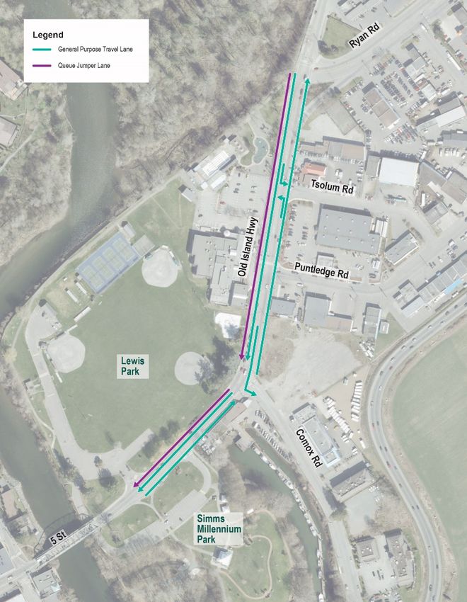
Communications with traffic control personnel will be explored in order to
ensure access to the bridge by emergency services can happen as easily as
possible.
Commercial Vehicles/Oversize Vehicles
As the bridge will have a maximum height of 3.6m, some large vehicles will not
be able to use the Fifth Street Bridge. Instead these vehicles will need to use
the 17th Street Bridge. The signage and communication regarding this will
need to be developed as part of the communications strategy.
Pedestrians and Cyclists
It is preferable to keep the underpass open to pedestrians and cyclists on both
sides of the bridge, but the park side is higher priority. Use of shipping
containers or another measure can be considered to separate pedestrians and
cyclists from construction activities and protect them from any potential
overhead hazards. Shipping containers are frequently used to protect
pedestrians from overhead hazards when there is construction adjacent to the
sidewalk. However, the bridge has very low clearance and there may not be
sufficient space for a shipping container.
On the Lewis Park side, if the underpass is closed to pedestrians and cyclists,
flaggers should be used to direct the pedestrian and cyclist movements and
facilitate crossing of 5th Street. However, each crossing of 5th Street on the
Lewis Park side will impact the single lane alternating operation and reduce
the vehicle capacity.
On the downtown side, pedestrians and cyclists will be able to cross Anderton
Avenue without any conflicts while traffic is entering downtown and then
cross 5th Street without any conflicts while traffic is leaving downtown.
Park Access
Access to the Lewis Park and/or Millennium Simms Park parking lots should
be maintained for park users and as a potential park-and-ride or park-and-
walk/bike location.
Traffic accessing the parking lots could be permitted to utilize the priority
vehicle lane which would provide a time savings and incentive to bike/walk
across the bridge.
FIFTH STREET REHABILITATION TRAFFIC MANAGEMENT STRATEGY – DRAFT REPORT 4
City of Courtenay | July 2020
The right-out access from Lewis Park to the bridge is proposed to be closed to
prevent short-cutting traffic from using the park to bypass the traffic queues
on 5th Street/Old Island Highway.
If it is not practical to maintain vehicle access under the bridge between Lewis
Park and Millennium Simms Park, the splitter islands at the parking lot
accesses will need to be modified to enable left-out from Lewis Park and left-in
to Millennium Simms Park. Alternatively, a traffic control person could be used
to facilitate these movements.
During any periods where vehicle access under the bridge between the parks
cannot be maintained, closure of the Simms Millennium Parking lot should be
considered to minimize the disruption to traffic crossing the bridge caused by
vehicles attempting to make a left-turn into the parking lot.
FIFTH STREET REHABILITATION TRAFFIC MANAGEMENT STRATEGY – DRAFT REPORT 5
City of Courtenay | July 2020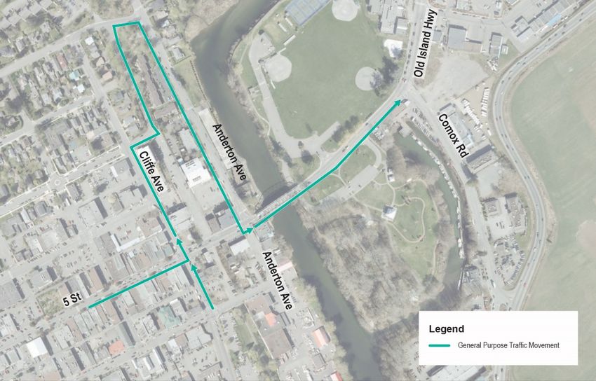
Figure E-0-1: Recommended Traffic Management Strategy

FIFTH STREET REHABILITATION TRAFFIC MANAGEMENT STRATEGY – DRAFT REPORT   6
City of Courtenay | July 2020
Transportation Demand Management
While the measures outlined above are intended to minimize the construction impacts on
road users, reducing the travel demand during peak periods is also an important strategy
and can provide significant benefits. Potential opportunities to encourage people to switch
from driving to walking, cycling or taking transit have been identified, including:
Park-and-ride (transit subsidy, rideshare, and shuttle)
Park-and-walk/bike
The proposed traffic management approach must be supported by a detailed
communications plan to ensure timely and broad awareness raising efforts across the Comox
Valley prior to and during construction.
FIFTH STREET REHABILITATION TRAFFIC MANAGEMENT STRATEGY – DRAFT REPORT 7
City of Courtenay | July 2020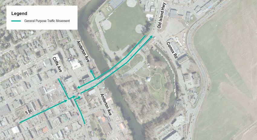
1.0 Overview
The Fifth Street Bridge plays an important role in the entire Comox Valley transportation
network. Completed in 1960, the 72-metre steel truss bridge has two vehicle lanes and 1.5-
metre sidewalks on both sides. Four important utilities run underneath the bridge - two
water mains, a Fortis gas line and Telus telecommunications line.
The bridge requires rehabilitation of various elements to maximize its service life to the City
of Courtenay (City). The City was successful in receiving $1.96-million in funding from the New
Building Canada- Small Communities fund, which requires rehabilitation of the bridge to
occur by March 31, 2022. Construction is planned for 2021.
To address the structural condition and safety of the current bridge, the scope of the Fifth
Street Rehabilitation Project includes:
Bridge deck replacement and cathodic protection systems
Structural repairs to the steel bridge structure
New handrails
Removal of rust and existing lead-based coating
Recoating of all steel to prevent corrosion
1.1 Purpose
The purpose of the traffic management strategy is to understand the impact that the bridge
rehabilitation will have on all modes of travel and to identify a pro-active strategy for
mitigating community impacts to the greatest extent possible. Mitigation strategies range
from traffic management, to travel demand management and strategic communications.
The strategy is intended to address concerns identified by the public and stakeholders, and
to be refined through on-going discussions.
The details of construction parameters and the impact on pedestrian, cycling and vehicle
traffic is identified in Section 2.0.
FIFTH STREET REHABILITATION TRAFFIC MANAGEMENT STRATEGY – DRAFT REPORT 8
City of Courtenay | July 20201.2 Key Characteristics
The following are key characteristics of the Fifth Street Bridge:
It is a 72-metre steel truss bridge that was constructed in 1960.
Two travel lanes (one in each direction) are provided, each is approximately
3.5m wide. 1.5m sidewalks are provided on both sides.
Dedicated cycling facilities are not currently provided on the bridge. Cyclists
either ride in line with vehicles or dismount and use the sidewalks.
Underpasses are provided on both the west and east sides of the bridge that
allow people who walk and cycle to pass from one side to the other.
Four utilities run underneath the bridge - two watermains, a Fortis gas line,
and Telus telecommunications line.
Approximately 20,000 vehicles, 160 buses, 650 pedestrians and 500 cyclists
cross the bridge each day 2.
2
Vehicle volumes based on figures from the Transportation Master Plan (2019), pedestrian and cyclist data based on
summertime counts completed by the Comox Valley Cycling Coalition, and bus data provided by BC Transit.
FIFTH STREET REHABILITATION TRAFFIC MANAGEMENT STRATEGY – DRAFT REPORT 9
City of Courtenay | July 20202.0 Construction Parameters
The rehabilitation work is anticipated to take approximately six months. Timing will
ultimately depend on the final extent of the rehabilitation works and the approach to
construction phasing. The traffic management strategy plans for one travel lane to remain
open and access for pedestrians and cyclists will be maintained through the duration of
construction. The recommendations in this report are based this construction approach and
resulting traffic management requirements. However, the recommendations in this Traffic
Management Strategy will likely be refined in conjunction with the successful contractor and
implementation will be subject to the contractor’s work plan and the available budget.
The rehabilitation includes two primary elements that would impact all modes of traffic:
The existing concrete bridge deck will be removed and replaced; and
Structural repairs to the underside of the bridge and a complete re-coating of
the steel structure, which includes a scaffolding and wrap structure that
reduces the vertical and horizontal clearances for travel on the bridge
To safely complete the rehabilitation work, multi-modal travel will be impacted by the
following conditions:
The scaffolding required to allow the recoating work may reduce the height
clearance to 3.6m (reduced from the current 4.6m);
The travel lane width may be reduced to 3.0m during construction (reduced
from the current approximately 3.5m width);
The free space within the wrapping will be approximately 6.0m with half of the
space being allocated to pedestrians and cyclists;
The scaffolding is expected to encapsulate the existing bridge sidewalks,
requiring that people who walk and cycle are accommodated in a dedicated
space on the bridge roadway.
FIFTH STREET REHABILITATION TRAFFIC MANAGEMENT STRATEGY – DRAFT REPORT 10
City of Courtenay | July 20203.0 Community Input
Courtenay residents and representatives from local stakeholder organizations were engaged
in the process of developing this traffic management strategy for rehabilitation of the Fifth
Street Bridge. The intent was to ensure that concerns related to traffic interruptions during
the rehabilitation works were understood and could be considered fully when planning the
traffic management strategy.
The following sections provide a summary of key feedback from the public and stakeholders.
3.1 Methods
Public and stakeholder feedback has been primarily received via three methods:
1. A survey was made available to the public from Tuesday, November 12 to
December 06, 2019 seeking feedback on the bridge rehabilitation project. A total of
643 survey responses were received online and in print.
2. An open house was hosted on Thursday, November 21st from 5:00 to 7:00pm at the
Florence Filberg Centre. A total of 98 people attended.
3. Letters were sent out to over 20 stakeholder organizations in the Comox Valley
inviting them to a one-on-one meeting with City staff and project consultants.
Meetings have been held with many of the invited groups.
3.2 Feedback Received
The feedback received has helped inform the traffic management strategy, including
developing a full understanding of public and stakeholder concerns as well as helping to
identify management approaches. The following are some of the key feedback that was
received:
Reducing congestion and maintaining access for all modes is of highest
priority.
Adjustments in travel behavior are most likely to include taking an alternate
route, planning for additional travel time, and travelling outside peak periods
(limited support was shown for taking the bus and carpooling).
Maintaining access for emergency services and public transit is an important
consideration.
A full summary of public and stakeholder feedback is provided in the What We Heard: Fifth
Street Bridge Rehabilitation Project, Phase 1 Engagement Summary document, which was
presented to council on January 27th, 2020.
FIFTH STREET REHABILITATION TRAFFIC MANAGEMENT STRATEGY – DRAFT REPORT 11
City of Courtenay | July 20204.0 Traffic Conditions - No Construction
The current traffic conditions and travel patterns in Courtenay, including daily traffic profiles,
typical congestion and travel times near the bridges and the origins and destinations of
traffic using the Fifth Street Bridge have been reviewed and are summarized in the sections
below.
4.1 Daily Traffic Profile at the Bridges
24-hour traffic counts have been analyzed for the three bridge crossings (Fifth Street Bridge,
17th Street Bridge, Piercy Bridge) to obtain an understanding of the traffic profile in terms of
peak hour and traffic volume.
The traffic for all three bridges generally reaches a morning peak around 8 am and then
continuously builds throughout the day and reaches the afternoon peak at between 4 pm
and 5 pm. The directional traffic on all three bridges is generally balanced. During the PM
peak hour, Fifth Street Bridge, 17th Street Bridge, and Piercy Bridge carry approximately 1000,
1500, and 250 vehicles per hour per direction respectively. See Figure 4-1 through Figure 4-3.
24-Hour Weekday Profile, Fifth Street Bridge
(October, 2018)
3,000
2,500
Vehicle Volumes
2,000
1,500
1,000
500
0
0
1
2
3
4
5
6
7
8
9
10
11
12
13
14
15
16
17
18
19
20
21
22
23
Hour
EB WB Two-way
Figure 4-1. 24-Hour Traffic Volume Profile (Fifth Street Bridge)
FIFTH STREET REHABILITATION TRAFFIC MANAGEMENT STRATEGY – DRAFT REPORT 12
City of Courtenay | July 202024-Hour Weekday Profile at 17th Street Bridge
(May, 2016)
3,000
2,500
Vehicle Volumes
2,000
1,500
1,000
500
0
1 2 3 4 5 6 7 8 9 10 11 12 13 14 15 16 17 18 19 20 21 22 23 24
Hour
EB WB Two-way
Figure 4-2. 24-Hour Traffic Volume Profile (17th Street Bridge)
24-Hour Weekday Profile at Piercy Bridge
(October, 2018)
3,000
2,500
Vehicle Volumes
2,000
1,500
1,000
500
0
0
1
2
3
4
5
6
7
8
9
10
11
12
13
14
15
16
17
18
19
20
21
22
23
Hour
NB SB Two-way
Figure 4-3. 24-Hour Traffic Volume Profile (Piercy Bridge)
FIFTH STREET REHABILITATION TRAFFIC MANAGEMENT STRATEGY – DRAFT REPORT 13
City of Courtenay | July 20204.2 Typical Traffic Condition Google Typical Traffic indicates that afternoon traffic conditions are typically worse than morning conditions. Traffic pressure is generally concentrated around the City’s core areas and major connections including the Fifth and 17th Street bridges, Cliffe Avenue and Ryan Road. See Figure 4-4. Based on observed traffic counts and traffic performance from Google Traffic, the Fifth Street and 17th Street bridges appear to operate near or at full capacity during the PM peak period. Typical Traffic, Morning Peak (8:00am) Typical Traffic, Afternoon Peak (4:30pm) Figure 4-4. Typical Traffic Conditions in Courtenay (Source: Google Traffic) FIFTH STREET REHABILITATION TRAFFIC MANAGEMENT STRATEGY – DRAFT REPORT 14 City of Courtenay | July 2020
On certain days, actual traffic performance is worse than Google Typical Traffic’s long-term
average. Figure 4-5 below illustrates one Thursday in November 2019 where the travel
speeds on bridges and major connections were much slower than usual.

 Google Live Traffic (4:30pm Thursday November 28, 2019)

Figure 4-5. Live Traffic Conditions in Courtenay (Source: Google Traffic)

FIFTH STREET REHABILITATION TRAFFIC MANAGEMENT STRATEGY – DRAFT REPORT                         15
City of Courtenay | July 2020
4.3 Travel Pattern (Origin + Destination)
The marjority of vehicles using the Fifth Street Bridge travel between downtown Courtenay
and areas in east Courtenay via Ryan Road or Old Island Highway. Origins and destinations of
Fifth Street Bridge traffic is illustrated in Figure 4-6.

A limited number of Fifth Street Bridge vehicles access the area via Cliffe Avenue and
Highway 19a/Comox Road. These vehicles are assumed to cross the Courtenay River via the
17th Street Bridge.

Eastbound (Leaving Downtown)                           Westbound (Entering Downtown)

Figure 4-6. Origin and Destination of Fifth Street Bridge Traffic (Source: Travel Demand Model)

FIFTH STREET REHABILITATION TRAFFIC MANAGEMENT STRATEGY – DRAFT REPORT                            16
City of Courtenay | July 2020
4.4 Travel Time
There are three options to cross the Courtenay River when travelling between east and west
Courtenay, as shown in Figure 4-7. Generally, the travel distance via the Fifth Street Bridge or
17th Street Bridge is much less as compared to the Piercy Bridge, which requires circuitous
routing via Piercy Road / Condensory Road.

Figure 4-7. Courtenay River crossing options between east and west Courtenay

Travel times to leave and enter downtown Courtenay during a typical weekday PM peak hour
have been estimated using Google Typical Traffics information.

Table 4-1 summarizes the typical travel time and distance between Cliffe Avenue and Ryan
Road via the three routes illustrated in the figure above.

FIFTH STREET REHABILITATION TRAFFIC MANAGEMENT STRATEGY – DRAFT REPORT                        17
City of Courtenay | July 2020
Condensory Rd
                                Fifth Street Bridge      17th Street Bridge
                                                                                    Bridge

                                Distance     Travel     Distance     Travel    Distance   Travel
                                  (km)       Time         (km)       Time        (km)     Time

 From Cliffe Ave to Ryan                      4-8                                         10-14
                                                                    5-10 min
           Rd                                 min                                          min
                                 2.4km                   3.5km                  8.1km
  From Ryan Rd to Cliffe                      5-10                                        10-16
                                                                    6-12 min
          Ave                                 min                                          min

Table 4-1. Google Travel Time between Cliffe Avenue and Ryan Road

FIFTH STREET REHABILITATION TRAFFIC MANAGEMENT STRATEGY – DRAFT REPORT                             18
City of Courtenay | July 2020
5.0 Traffic Conditions - During Construction
The following describes how the planned rehabilitation works will impact traffic. This includes
both the impact on the transportation function and capacity on the bridge, as well as the
impact on local and network-wide traffic conditions. The preceding analysis also provides a
baseline against which possible mitigation options can be tested to ensure they will have
value in addressing traffic challenges.
During the rehabilitation work, the capacity on the Fifth Street Bridge will be reduced from
two lanes to one lane, as described in Section 2.0. Four scenarios for how the single lane
could be operated were developed. These scenarios are:
1. Single lane alternating - This scenario maintains traffic from both directions by
alternating eastbound and westbound traffic flows. Traffic control persons or
temporary traffic signals will be required at both ends of the bridge to allow / stop
traffic safely.
2. Westbound (WB) only open. - This scenario closes the bridge to eastbound traffic
and keeps it open in the westbound direction.
3. Eastbound (EB) only open - This scenario closes the bridge to westbound traffic and
keeps it open in the eastbound direction.
4. Mid-day direction change – This scenario operates the bridge in the westbound
direction in the morning and the eastbound direction in the afternoon, or vice-versa
A high-level analysis of the impact of the construction on the Fifth Street Bridge’s traffic
capacity and resulting network wide traffic performance has been assessed for the scenarios
during the PM peak hour. Visum 3 was utilized to estimate the change in traffic on each link
resulting from the reduced bridge capacity associated with each scenario. Traffic analysis
software Synchro and SimTraffic were used to perform traffic operational analysis. Signal
timing was optimized as necessary. For this analysis it was assumed that the mode share
splits remain unchanged and there are no impacts from emergency vehicles and transit
buses. Once a preferred option(s) is identified then more detailed analysis, including
consideration of transit and emergency vehicle accommodation will be completed.
The results and network impacts described below are for the PM peak hour which is the
busiest period for Courtenay’s road network. For most of the day the impacts will be less
3
Visum is a macro transportation demand model and was previously used to support the City’s Transportation
Master Plan
FIFTH STREET REHABILITATION TRAFFIC MANAGEMENT STRATEGY – DRAFT REPORT 19
City of Courtenay | July 2020significant. However, supporting the use of alternative transportation and encouraging off- peak travel to mitigate traffic pressures will be critical and highly recommended. 5.1 Scenario 1: Single Lane Alternating With single lane alternating traffic, the resulting capacity of the bridge is anticipated to be reduced by half to 500 vehicles per hour per lane. Most traffic is expected to divert to the 17th Street Bridge while a small number of motorists will divert via the Piercy Bridge. It is anticipated that both the Fifth Street and 17th Street bridges will operate over capacity during the peak periods. The Piercy Bridge has spare capacity but due to the much longer travel distance it is not an attractive option for many motorists. Consequently, more severe delays and queues are expected to occur resulting in longer peak periods along 17th Street, 5th Street, Cliffe Avenue and Ryan Road. SimTraffic results indicate that the average network travel time in Courtenay during the PM peak hour will increase by approximately 40% under this scenario. 5.2 Scenario 2: Westbound Only Open In this scenario, all eastbound traffic needs to travel via other bridges and the 17th Street Bridge is expected to receive most of the diverted traffic. Analysis shows that this scenario would result in gridlock, excessive delays, and long queue lengths throughout the network. The 17th Street Bridge eastbound and its intersection with Comox Road is the main constraint restricting downstream capacity. Eastbound queues from the 17th Street / Comox Road intersection extend back to the 17th Street / Cliffe Avenue intersection (as they currently do during select periods). Consequently, the diverted eastbound and northbound traffic cannot proceed through the 17th Street / Cliffe Avenue intersection. Significant construction would be required to increase capacity for the affected movements, and therefore this option is not recommended and is not further evaluated. 5.3 Scenario 3: Eastbound Only Open In this scenario, all westbound traffic needs to travel via other bridges, and 17th Street Bridge is expected to receive most of the diverted traffic. With no network modifications this scenario would also result in gridlock, excessive delays, and long queue lengths. One of the critical movements is the westbound right turn at 17th Street / Cliffe Avenue. Currently the westbound right turn is channelized with yield control since there is only one northbound receiving lane on Cliffe Avenue. Additionally, long southbound queues occur on Comox Road at 5th Street as there is a significant increase in demand for the westbound left-turn FIFTH STREET REHABILITATION TRAFFIC MANAGEMENT STRATEGY – DRAFT REPORT 20 City of Courtenay | July 2020
movement by motorists diverting to the 17th Street Bridge. The network constraints can be
mitigated through the following network changes:
17th Street / Cliffe Avenue - Convert one of the dual southbound to
eastbound left-turn lanes on Cliffe Avenue to create a second westbound
receiving lane. This enables the northbound right-turn traffic to have its own
receiving lane and operate as a free flow movement.
5th Street / Comox Road - Extend the existing westbound left-turn lane into
the current TWLTL (two-way left turn lane) at the 5th Street / Comox Road
intersection to provide more storage and add a protected westbound left-turn
phase to the signal (or use a traffic control person).
With the network improvements listed above, 17th Street Bridge is expected to accommodate
the additional westbound traffic to some degree. However, the 17th Street Bridge is expected
to be over capacity during the peak periods with more severe delays and queues compared
to current conditions, particularly in the southbound direction on Comox Road approaching
the 17th Street Bridge. SimTraffic results indicate that the average network travel time in
Courtenay during the PM peak hour will increase by approximately 35% under the eastbound
only open scenario.
5.4 Scenario 4: Mid-day Direction Change
This scenario is a hybrid of Scenarios 2 and 3 where the bridge would be operated as
eastbound only in the morning and westbound only in the afternoon or vice-versa
(westbound only in the morning and eastbound only in the afternoon). This can provide
benefits where there is different peak travel direction during the morning and afternoon
rush-hours. However, as illustrated in Figure 4-1, there is no peak travel direction in
Courtenay on the Fifth Street Bridge. During any hour of the day, the volume of vehicles
travelling eastbound or westbound across the bridge is essentially the same. Therefore,
changing the direction of the bridge operation mid-day will not provide any traffic efficiency
benefits over Scenario 2 or 3. This option is also likely to be more confusing to the public as
they must remember which direction traffic is flowing at different times of day and make the
signage/public information more complex as time of day and directional information would
also need to be communicated. Therefore, this option is not recommended or evaluated
further.
5.5 Summary and Recommendation
A high-level analysis of the three scenarios for the Fifth Street Bridge has identified that the
westbound only open scenario causes network-wide gridlock. All traffic leaving downtown
FIFTH STREET REHABILITATION TRAFFIC MANAGEMENT STRATEGY – DRAFT REPORT 21
City of Courtenay | July 2020must divert to the 17th Street Bridge which results in a significant increase in demand for the
left-turn from 17th Street to Comox Road. This movement does not have sufficient capacity
which causes congestion on 17th Street, Cliffe Avenue, 5th Street and eventually across the 5th
Street Bridge and Ryan Road. Therefore, this option is not recommended. Queuing during
the PM peak hour is significantly higher under this scenario, as shown in Figure 5-1.
The mid-day direction change scenario was found to provide no traffic benefits since there is
not a peak travel direction on the Fifth Street Bridge and therefore is not recommended.
The single lane alternating and eastbound only open options both result in a similar level of
overall delay on the network. However, both options will result in long delays and queue
lengths during the peak periods. Single lane alternating allows residents and commuters
similar access to what they currently enjoy, albeit maybe more slowly. It also provides
continued access to and from the downtown. Additionally, single lane will provide more
balanced network performance at bridges as well as highways and municipal roads.
Therefore, single lane alternating is recommended.
Scenario 3. Eastbound Open
Scenario 1. Single-Lane Alternating Scenario 2. Westbound Open
(Can be Considered but Not
(Recommended) (Not Recommended)
Recommended)
Figure 5-1. Estimated PM Peak Hour Queuing for Traffic Management Options
FIFTH STREET REHABILITATION TRAFFIC MANAGEMENT STRATEGY – DRAFT REPORT 22
City of Courtenay | July 20206.0 Traffic Management
Based on the traffic analysis results in Section 5.0, review of community and stakeholder
input, and through discussions with the City Staff, the Single Lane Alternating option was
selected as the preferred option for traffic management on the bridge. This option provides a
more balanced network performance at the bridges as well as highways and municipal roads
and is most responsive to the concerns identified by the public and stakeholders. Details of
the traffic management plan in the following section of this document correspond to the
Single Lane Alternating option, which includes consideration of the following items:
Traffic queue storage locations to minimize disruption to local businesses.
Accommodation of priority vehicles.
Connectivity for pedestrian and cyclist facilities.
Traffic control methods including time-of-day modifications to the traffic
management to best accommodate peak and off-peak traffic.
Intersection Modifications; and
Travel time forecasts.
Figure 6-1: illustrates the key considerations to the Traffic Management Strategies.
FIFTH STREET REHABILITATION TRAFFIC MANAGEMENT STRATEGY – DRAFT REPORT 23
City of Courtenay | July 2020Figure 6-1: Overall Traffic Management Strategy FIFTH STREET REHABILITATION TRAFFIC MANAGEMENT STRATEGY – DRAFT REPORT 24 City of Courtenay | July 2020
6.1 Queue Storage Location Comparison (General Purpose Traffic)
With the reduced capacity due to use of single lane alternating traffic, congestion and
queues can be expected. For traffic leaving downtown two options for managing the queue
have been identified:
5th Street – illustrated in Figure 6-2, this option requires minimal network
changes and uses 5th Avenue to store traffic queues; or
Anderton Avenue – illustrated in Figure 6-3, this option uses Cliffe Avenue and
Anderton Avenue north of 5th Street to store traffic queues by converting the
right-in at Anderton Avenue to left-out and restricting a few movements on
5th Street.
Figure 6-2: 5th Street Queue Option
FIFTH STREET REHABILITATION TRAFFIC MANAGEMENT STRATEGY – DRAFT REPORT 25
City of Courtenay | July 2020Figure 6-3: Anderton Avenue Queue Option 6.1.1 5th Street Queue Option In this option there are minimal changes to the existing road network and routing for traffic leaving downtown via the Fifth Street Bridge. Traffic would queue along 5th Street and the various side roads, including Cliffe Avenue. Estimated queue lengths during the PM peak hour are illustrated in Figure 6-4, below. The actual queue lengths will vary depending upon day-to-day traffic fluctuations and how behaviour changes in response to the construction (change of trip time, use of 17th Street Bridge, walk or cycle, etc.). However, congestion on 5th Street and the side roads can be expected which will limit access to local businesses and access to parking downtown. 6.1.2 Anderton Avenue Queue Option An alternative approach is to restrict 5th Street from Cliffe Avenue to Anderton Avenue to local traffic only (no access to the bridge) and require all traffic leaving downtown to access the bridge from the north side of Anderton Avenue as shown in Figure 6-3. This would require converting the right-in at Anderton Avenue and 5th Street to a left-out and re-routing transit. The transit re-routing is discussed further in Section 6.2 as part of the Priority Vehicles. FIFTH STREET REHABILITATION TRAFFIC MANAGEMENT STRATEGY – DRAFT REPORT 26 City of Courtenay | July 2020
Estimated queue lengths during the PM peak hour are illustrated in Figure 6-4, below. The
actual queue lengths will vary depending upon day-to-day traffic fluctuations and how
behaviour changes in response to the construction (change of trip time, use of 17th Street
Bridge, walk or cycle, etc.). This option is intended to minimize the impact of congestion and
queuing on local businesses by moving the queue out of the downtown core, off 5th Street
and most of Cliffe Avenue to Anderton Avenue.

On Anderton Avenue, removing the parking on the west side of the road should be
considered with use of this space as a lane for traffic queuing to access the bridge. This would
enable 2-way free flow traffic to be maintained for access to destinations on Anderton
Avenue, such as the Filberg Centre. Similarly, creation of a dedicated queueing lane on 1st
Street should be considered. There appears to be sufficient room to accommodate a queue
on the right side of 1st Street while maintaining two-way traffic. This will enable access to the
Condensory Bridge and destinations on Anderton Avenue to be maintained. Traffic control
personnel may be required to help manage the queue, especially during the initial phase of
the construction.

Additionally, use of the laneway between Cliffe Avenue and Anderton Avenue for traffic
destined to the bridge is suggested for consideration 4. This laneway appears to have minimal
direct accesses and its use would minimize the impact of queues on the residents on Cliffe
Avenue between 3rd Street and 1st Street.

6.1.3 Queue Storage Location Recommendation

As discussed, above, a high-level traffic analysis has been completed to compare the PM
peak hour queues for the 5th Street and Anderton Avenue options as illustrated in Figure 6-4.
The Anderton Avenue Detour scenario will store most of the queues on Anderton Avenue
instead of 5th Street, which will minimize impacts to the downtown core businesses.
Therefore, the Anderton Avenue Queue option is recommended and is the basis of the
subsequent sections. Traffic control methods/devices at key locations will be discussed in
detail in Section 6.4 along with intersection modifications in Section 6.5.

4
 As an alternative to using the laneway, traffic could be directed to continue on Cliffe Avenue to 1st Street. This can
be considered further at future stages of the Traffic Management Plan Development with consideration of the trade-
offs of potential impacts to residents versus a higher volume of traffic utilizing the laneway.

FIFTH STREET REHABILITATION TRAFFIC MANAGEMENT STRATEGY – DRAFT REPORT                                             27
City of Courtenay | July 2020
5th Street Queue Option Anderton Avenue Queue Option
Figure 6-4: Estimated Queue Lengths
Under the Anderton Avenue Queue option, large vehicles (for example, trucks that are less
than 3.6m in height) leaving Downtown Courtenay will be directed to travel via 6th
Street/Anderton Avenue. Additionally, large vehicles that exceed the 5th Street Bridge’s
height restriction (approximately 3.6m) or vehicles with trailers/boats will be directed to use
the 17th Street Bridge or Piercy Bridge instead.
Turning templates for key movements at key locations along Cliffe Avenue, have been
reviewed to ensure that vehicles can turn safely during the construction phase. The
movements that were evaluated include:
Cliffe Avenue/6th Street/Anderton Avenue route for trucks (Truck Route)
Right turn from 5th Street onto Cliffe Avenue
Left turn from Cliffe Avenue onto 6th Street
Left turn from 6th Street onto Anderton Avenue
Right turn from Anderton Avenue onto the Fifth Street Bridge
Cliffe Avenue/3rd Street/Laneway/1st Street/Anderton Avenue route for general purpose traffic
(GP Route)
Left turn from 5th Street to Cliffe Street
FIFTH STREET REHABILITATION TRAFFIC MANAGEMENT STRATEGY – DRAFT REPORT 28
City of Courtenay | July 2020 Right turn from Cliffe Street to 3rd Street
Left turn from 3rd Street to laneway
Right turn from laneway to 1st Street
Right turn from 1st Street to Anderton Avenue
Left turn from Anderton Avenue to the Fifth Street Bridge
The review indicates that the design vehicles (heavy single unit trucks for trucks and
motorhomes for general purpose traffic) generally are able to turn along the designed
detours. For the truck route, trucks may need to make a wider right turn from 5th Street onto
Cliffe Avenue by using the middle lane instead of the curbside lane. At Anderton Avenue
where trucks need to turn right onto the Fifth Street Bridge, they may drive over the painted
median on 5th Street. For the general-purpose route, the full width of 3rd Street and laneway
will be taken for turning, which are as expected and acceptable.
Clear signage and a comprehensive communications strategy will be required to direct these
vehicles to travel via 6th Street/Anderton Avenue and/or the 17th Street and Piercy Bridges.
6.2 Priority Vehicles
The needs of priority vehicles (emergency services, BC Transit, School Buses, etc.) require
specific consideration as part of the traffic management strategy development to ensure
they experience as little delay as possible. The following opportunities have been identified:
For traffic entering downtown, creation of a priority vehicle (queue jumper)
lane on the westbound bridge approach to enable BC Transit and emergency
services to bypass the general traffic queues.
For traffic leaving downtown, utilizing a separate queuing space for general
purpose traffic to provide priority access to the bridge for BC Transit and
emergency services.
Enabling communication between the traffic control people and emergency
services to enable them to pro-actively manage traffic for any approaching
emergency vehicles. This could be achieved by providing the traffic control
people and emergency services with radios on the same frequency.
Use of temporary signals instead of traffic control people is recommended for
the night time period when traffic volumes are lower. The signals should be
able to be operated with a relatively short cycle length that will minimize
delays for emergency services. However, opportunities to provide emergency
services pre-emption as part of any temporary traffic signals can also be
explored. If emergency pre-emption is not possible with the temporary traffic
FIFTH STREET REHABILITATION TRAFFIC MANAGEMENT STRATEGY – DRAFT REPORT 29
City of Courtenay | July 2020signals and emergency services priority is necessary at night, an alternative
approach would be to have traffic control people on-site overnight.
Volunteer fire department members may need to cross the bridge in a
personal vehicle to access the fire hall and respond to a call. These first
responders would also be able to use the priority vehicle lane/route. Each
responder could have a bright sign or piece of paper to put on their dash or
otherwise display to indicate to the traffic control people that they are
responding to a call and permitted to use the priority vehicle facilities.
6.2.1 Westbound (Entering Downtown) Priority Vehicle (Queue Jumper)
Lane
On the park side of the bridge, 5th Street has a 3-lane cross-section from the bridge to
Comox Road. It consists of one through lane in each direction and an eastbound right turn
lane to Comox Road. Given the relatively low eastbound right turn volumes, the right turn
lane can be combined with the through lane to allow for adding a queue jumper lane.
The segment of Old Island Highway between Comox Road and Ryan Road is also a three-lane
road consisting of one through lane in each direction and left turn lanes or TWLT (two-way
left turn) lanes in the middle. A variety of factors including current lane geometry, expected
queue length during construction, and bus routes, were reviewed to determine if it is feasible
to temporarily add a fourth lane on Old Island Highway to accommodate priority vehicles.
Key findings include:
According to BC Transit’ bus routes and schedule information, most of the
buses heading to Downtown Courtenay via the Fifth Street Bridge come from
Ryan Road;
The queue length on 5th Street/Old Island Highway during construction is
expected to build up beyond Ryan Road; and
The road width of this segment ranges between 13.7m to 15.2m (roughly
measured using aerial images).
Based on the findings, the segment of Old Island Highway provides sufficient space to
accommodate a temporary priority lane, assuming 3.3m 5 for a general-purpose travel lane,
3.5m for a left turn lane and 3.5m for a queue jumper lane (13.6m in total) 6. Most access along
5
3.0m is the minimal width for general travel through lane as per TAC’s Geometric Design Guide for
Canadian Roads, Chapter 4, Table 4.2.3
6
3.3m as the minimal width for bus lanes as per BC Transit Design Guidelines, Chapter 5.
FIFTH STREET REHABILITATION TRAFFIC MANAGEMENT STRATEGY – DRAFT REPORT 30
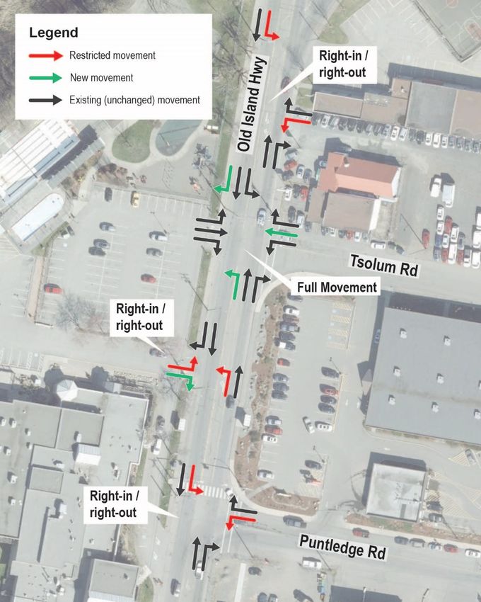
City of Courtenay | July 2020Old Island Highway should be restricted to right-in/right-out to minimize conflicts. This is discussed further in Section 6.5.2. The queue jumper lane, located on the right side of the westbound approach, can serve priority vehicles including emergency vehicles and transit buses. Park users can also utilize this lane to bypass traffic queues with a few exceptions which will be further discussed in Section 6.5.3. Figure 6-5 illustrates the recommended queue jumper lane location. Figure 6-5: Queue Jumper Lane (East Side) 6.2.2 Eastbound (Leaving Downtown) Priority Route The current right-in only from the Fifth Street Bridge to Anderton Avenue is changed to left- out only to enable general purpose traffic to access the bridge via Cliffe Avenue, 1st Street and Anderton Avenue as discussed in Section 6.1. Therefore, all buses entering downtown Courtenay via the Fifth Street Bridge can no longer turn right onto Anderton Avenue and will FIFTH STREET REHABILITATION TRAFFIC MANAGEMENT STRATEGY – DRAFT REPORT 31 City of Courtenay | July 2020
need to be rerouted. As illustrated in Figure 6-6, the proposed re-routing for buses is to
proceed straight on 5th Street before turning right onto Cliffe Avenue, right onto 1st Street,
and finally right to Anderton Avenue. This route will enable the same locational stops with
temporary relocation of bus stops to the opposite side of the road which will need to be
coordinated with BC Transit.

As two-way traffic is being maintained on Anderton Avenue in addition to the bridge queue,
buses can use the travel lane to by-pass the queue and get to the front of the line for the
bridge.

If general purpose traffic is directed to use the laneway between Cliffe Avenue and Anderton
Avenue, large trucks may find some of the turns too tight. Instead large trucks can use the
same routing as the buses or access the bridge via the south side of Anderton Avenue (6th
Street, left on Anderton Avenue, right onto the bridge).

Emergency services can use the same routing as buses, or alternatively they can access the
Fifth Street Bridge directly from Fifth Street by ignoring the local traffic only restriction at 5th
Street and Cliffe Avenue.

FIFTH STREET REHABILITATION TRAFFIC MANAGEMENT STRATEGY – DRAFT REPORT                            32
City of Courtenay | July 2020
Figure 6-6: Transit Routes (West Side)

6.3 Pedestrians and Cyclists
Providing pedestrian and cyclist facilities for individuals to safely navigate during the
construction phase is crucial. Good connectivity for pedestrians and cyclists will not only
ensure the users’ safety but also encourage individuals to choose walking or cycling instead
of driving and help reduce congestion.

The Fifth Street Bridge currently allows pedestrians and cyclists on both sides of the bridge.
On the west (downtown) side of the bridge, there is a pathway underneath the bridge that
connects to Anderton Avenue. On the east side of the bridge, there is a pathway underneath
the bridge connecting Lewis Park and Simms Millennium Park.

FIFTH STREET REHABILITATION TRAFFIC MANAGEMENT STRATEGY – DRAFT REPORT                        33
City of Courtenay | July 2020
During construction, the bridge should maintain connections for pedestrians and cyclists on
one side at a minimum. The south side is preferred because it involves fewer conflicting
points between pedestrians and cyclists and vehicles on the west (downtown) end of the
bridge.

It is recommended to maintain the underpass on both sides of the bridge open for
pedestrians and cyclists. However, some construction activities may necessitate a closure.
Use of shipping containers or another method to separate pedestrians and cyclists from
construction activities and protect them from any overhead work occurring on the underside
of the bridge could be considered to enable pedestrians and cyclists to use the underpass
while there is construction in the vicinity. Shipping containers are frequently used to protect
pedestrians from overhead hazards when there is construction adjacent to the sidewalk and
the sidewalk would otherwise need to be closed. However, the bridge has very low clearance
and there may not be sufficient space for a shipping container.

If the underpass needs to be closed to pedestrians and cyclists, use of flaggers on the Lewis
Park side to direct their movements and facilitate crossing of 5th Street should be considered.
However, it is important to note that each crossing of 5th Street on the Lewis Park side will
impact the single lane alternating operation and reduce the vehicular capacity. Therefore,
closing the underpass to pedestrians and cyclists on the Lewis Park side should be
considered a less desirable solution and only utilized if absolutely necessary and/or for a
limited period when there is work occurring in the immediate vicinity of the underpass.

On the downtown side pedestrians and cyclists can cross Anderton Avenue, then 5th Street.
The proposed operation of the single lane alternating traffic with vehicles entering
downtown using 5th Street while traffic exiting downtown using Anderton Avenue will result
in opportunities to cross both roads with no conflicting traffic.

6.4 Traffic Control Methods
During the daytime peak period (between approximately 7:00am and 7:00pm), use of traffic
control people on both sides of the bridge to direct traffic and facilitate the single lane
alternating is recommended. Traffic control people are better able than temporary traffic
signals to respond to variations in traffic demand to maximize the throughput of the bridge.
Additionally, they can adjust the traffic control to prioritize emergency services and transit.
Figure 6-7 illustrates the locations of the traffic control people. Additional traffic control
people may be required to monitor signs and the detour operations.

FIFTH STREET REHABILITATION TRAFFIC MANAGEMENT STRATEGY – DRAFT REPORT                            34
City of Courtenay | July 2020
You can also read