Scheme Amendment Report - Marshall Road Local Centre, Myaree, WA - v - City of Melville
←
→
Page content transcription
If your browser does not render page correctly, please read the page content below
Scheme Amendment Report

         Marshall Road Local Centre,
                        Myaree, WA

v

                            Prepared for
                           Coxon Group

                              July 2020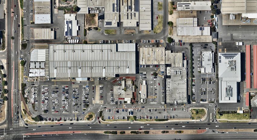
Copyright Statement 2020

© Planning Solutions (Aust) Pty Ltd

All rights reserved. Other than for the purposes of and subject to the conditions prescribed under the Copyright
Act 1968 (Cth), no part of this report may be reproduced, stored in a retrieval system or transmitted in any form or
by any means, electronic or otherwise, without the prior written permission of Planning Solutions (Aust) Pty Ltd.

No express or implied warranties are made by Planning Solutions (Aust) Pty Ltd regarding the information and
analysis contained in this report. In particular, but without limiting the preceding exclusion, Planning Solutions
(Aust) Pty Ltd will not verify, and will not assume responsibility for, the accuracy and completeness of information
provided to us.

This report has been prepared with particular attention to our Client’s instructions and the relevant features of the
subject site. Planning Solutions (Aust) Pty Ltd accepts no liability whatsoever for:

1. a third party’s use of, or reliance upon, this report;
2. use of, or reliance upon, this report in relation to any land other than the subject site; or
3. the Client’s implementation, or application, of the strategies recommended in this report.

Direct all inquiries to:

Planning Solutions
Level 1, 251 St Georges Terrace
Perth, WA 6000

All correspondence to:
GPO Box 2709
Cloisters Square PO 6850

Phone:              08 9227 7970
Fax:                08 9227 7971
Email:              admin@planningsolutions.com.au
Web:                www.planningsolutions.com.au
Project details
Job number        6362
Client            Carrooda Pty Ltd & Sansom Nominees Pty Ltd
Prepared by       Planning Solutions

Document control
Revision number   File name                                    Document date
Rev 0             200220 6362 Draft Scheme Amendment Report    20 February 2020
Rev 1             200227 6362 Scheme Amendment Report          27 February 2020
Rev 2             200423 6362 Scheme Amendment Report          20 April 2020
Rev 3             200731 6362 Scheme Amendment Report          31 July 2021
Contents
1           Preliminary............................................................................................................................................ 2
1.1         Introduction ............................................................................................................................................ 2
2           Site details ............................................................................................................................................ 3
2.1         Land description ..................................................................................................................................... 3
2.2         Location and site context ....................................................................................................................... 3
2.2.1       Regional context .................................................................................................................................... 3
2.2.2       Local context, land use and topography................................................................................................. 3
3           Proposed scheme amendment ........................................................................................................... 6
3.1         Background and key issues ................................................................................................................... 6
3.2         Proposed amendments to LPS6 ............................................................................................................ 7
4           Strategic planning framework ............................................................................................................. 8
4.1         Perth and Peel @ 3.5 Million.................................................................................................................. 8
4.2         State Planning Policy 4.2 – Activity Centres for Perth and Peel............................................................. 9
4.3         City of Melville Local Commercial and Activities Centre Strategy .......................................................... 9
4.4         City of Melville Local Planning Strategy ............................................................................................... 10
5           Statutory planning framework .......................................................................................................... 12
5.1         Metropolitan Region Scheme ............................................................................................................... 12
5.2         City of Melville Local Planning Scheme No.6 ....................................................................................... 12
5.2.1       Zoning and other classifications ........................................................................................................... 12
5.2.2       Land Use Permissibility ........................................................................................................................ 13
5.2.3       Development standards ....................................................................................................................... 13
6           Conclusion.......................................................................................................................................... 16

Figures

Figure 1:                   Aerial Site Plan
Figure 2:                   Central Sub-Regional Planning Framework
Figure 3:                   Local Planning Strategy Extract
Figure 4:                   Existing Zoning (LPS6)
Figure 5:                   Proposed Zoning (LPS6)

Appendices

Appendix 1:                 Certificates of Title

                                                                                                                                                                     1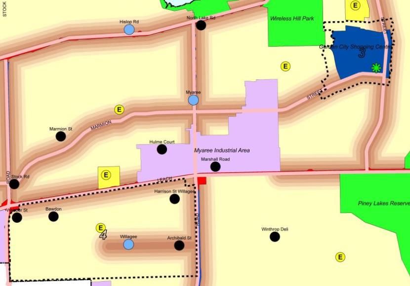
Marshall Road Local Centre
                                                    Proposed Amendment to City of Melville Local Planning Scheme No.6

1          Preliminary
1.1 Introduction

This report has been prepared by Planning Solutions on behalf of Carrooda Pty Ltd & Sansom Nominees Pty Ltd,
the registered proprietor of Lot 801 (No. 208) Leach Highway and Lot 802 (No. 1) Marshall Road, Myaree. Planning
Solutions has prepared the following report in support of a request to amend the City of Melville (City) Local Plan-
ning Scheme No. 6 (LPS6) to expand the range of land uses capable of approval within the Marshall Road Local
Centre, being the area currently subject to a Centre (C4) zoning and Restricted Use (R2) classification under LPS6.

The proposed scheme amendment seeks to remove the Restricted Use (R2) classification from the Marshall Road
Local Centre, and add an Additional Use (A19) classification. Such a modification is necessary to ensure com-
mercially viable and contextually appropriate land uses are capable of being approved in this location. The site’s
Centre (C4) zoning will continue to apply to the site, with land use permissibility in accordance with the zoning table
and Additional Use (A19) provisions of LPS6 (consistent with the strategic planning framework and planned activity
centres hierarchy).

This report will discuss various issues pertinent to the proposal, including:
    • Site details.
    • Town planning considerations.
    • Proposed scheme amendment.

We respectfully seek the support of the City, WA Planning Commission (WAPC) and Minister for Planning for the
proposed scheme amendment, having due regard for the provisions of relevant state and local planning frame-
works.

                                                                                                                     2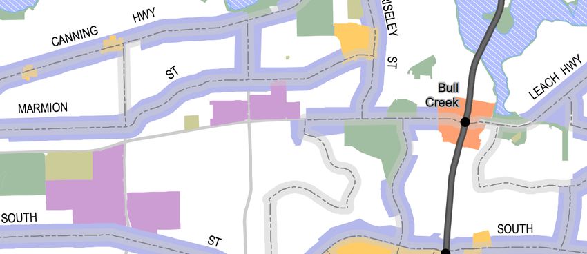
Marshall Road Local Centre
                                                                   Proposed Amendment to City of Melville Local Planning Scheme No.6

2             Site details
2.1 Land description

The subject site comprises those properties collectively referred to as the ‘Marshall Road Local Centre’, and subject
to the Centre (C4) zoning and Restricted Use (R2) classification under LPS6. Each of the affected properties is
described in Table 1 below:

Table 1: Subject Properties
 Address                        Lot Details              Lot Area         Existing development               Ownership

 208 Leach Highway,             Lot 801 on               21,203m2         Bunnings Warehouse.                Carrooda Pty Ltd & San-
 Myaree*                        Plan 33665               (2.12ha)                                            som Nominees Pty Ltd

 1 Marshall Road,               Lot 802 on               13,597m2         ‘Melville Central’, comprising     Carrooda Pty Ltd & San-
 Myaree                         Plan 33665               (1.36ha)         various large format retail ten-   som Nominees Pty Ltd
                                                                          ancies, restaurants, fast food
                                                                          outlets, market / specialty food
                                                                          retailers and liquor store.

 9 Marshall Road,               Lot 35 on Dia-           5,182m2          McDonald’s Fast Food Outlet        McDonald’s Properties
 Myaree                         gram 61855               (0.52ha)                                            (Australia) Pty Ltd

 11 Marshall Road,              Lot 36 on Dia-           5,182m2          Summit Homes office and ‘Style     Summit Development Cor-
 Myaree                         gram 61855               (0.52ha)         Studio’                            poration Pty Ltd
*Only a small portion of Lot 801 falls within the LPS6 Centre (C4) zone and Restricted Use (R2) area.

Certificates of Title for all affected properties are provided at Appendix 1.

Numerous easements and encumbrances are registered on the titles for Lots 801 and 802, however, are not ma-
terially relevant to this proposed scheme amendment.

2.2 Location and site context

2.2.1       Regional context

The subject site is located within the suburb of Myaree and the local government area of the City of Melville. It is
situated approximately 11 kilometres southwest of the Perth city centre, 6.5 kilometres east of the Fremantle stra-
tegic metropolitan centre, and 2 kilometres south west of the Booragoon secondary centre (Garden City). It is also
approximately 2.5 kilometres north west of the Murdoch University specialised activity centre.

The subject site is bounded by Leach Highway to the south and North Lake Road to the west. Leach Highway is
a major arterial road providing a regional road link between Fremantle to the west and Tonkin Highway to the east,
while North Lake Road provides an important link between Canning Highway to the north and Cockburn Central /
Beeliar Drive to the south.

2.2.2       Local context, land use and topography

The Marshall Road Local Centre is surrounded by, and effectively forms part of, the wider Myaree Mixed Business
precinct – an industrial area containing a range of diverse land uses, including almost all of the bulky goods floor-
space in the City of Melville.

                                                                                                                                       3
Marshall Road Local Centre
                                                    Proposed Amendment to City of Melville Local Planning Scheme No.6
Properties surrounding the Marshall Road Local Centre (north of Leach Highway) are generally characterised as
a mix of large format / bulky goods retailers (e.g. Bunnings) and light industrial / commercial activities (e.g. service
station, self-storage facility and auto repairs). To the south of the subject site and Leach Highway is the Robert
Street Park, along with low density residential development.

As previously noted, the subject site comprises four privately owned freehold lots, with existing development and
activities described as follows:
    •    Lot 801 – Bunnings Warehouse (contained entirely within the adjacent ‘Service Commercial’ zone, and
         only a small portion of the car park and vehicle access aisles falling within the ‘Centre C4’ zone / ‘Re-
         stricted Use R2’ area).
    •    Lot 802 – A variety of Fast food outlets, restaurants, a liquor store, fresh food market and specialty food
         retailers, along with some vacant retail tenancies arranged in multiple buildings.
    •    Lot 35 – McDonald’s Fast Food Outlet;
    •    Lot 36 – Summit Homes head office and ‘Style Studio’.

The subject site benefits from two vehicle crossovers to Leach Highway, and a single crossover to North Lake
Road. Vehicle access is also available from Hayden Court to the rear (north) of the subject site. A series of internal
easements within Lots 801 and 802 ensure that shared access is available across the subject site and to/from
existing crossovers.

Frequent bus services are available in immediate proximity to the subject site, with bus stops on Leach Highway
adjacent of Lot 802. Bus route 502 provides regular services between Fremantle and Bull Creek railway stations.

The subject site in generally flat, ranging in level between approximately 14m AHD and 17m AHD. Existing vege-
tation is limited to landscaping strips along road frontages, and shade trees within car parking areas. The subject
site is not classified as ‘Bushfire Prone’ according to the DFES Map of Bush Fire Prone Areas.

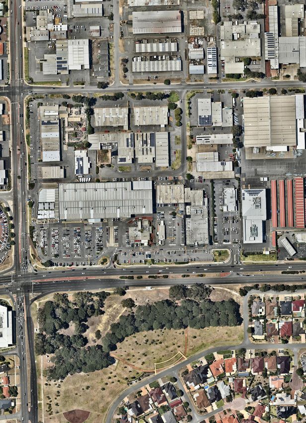
Refer Figure 1 – Aerial Site Plan.

                                                                                                                      4
LEGEND
Marshall Road Local Centre
McCOY STREET
NORTH
HAYDEN CIRCUIT
LAKE
ROAD
LOT 802 LOT 35 LOT 36
LOT 801
LEACH HIGHWAY
SCALE
DATE
1: 2,500 @ A4
20 February 2020
AERIAL PHOTOGRAPH FIGURE
FILE
REVISION
01 200220 6362 Aerial Photograph.dwg
1/DR/First Draft/20.02.2020
LOT 801 (208) LEACH HIGHWAY, LOT 802, 35 & 36
(1, 9 &11) MARSHALL ROAD
MYAREE, WA
DISCLAIMER: THIS DOCUMENT IS AND REMAINS THE PROPERTY OF PLANNING SOLUTIONS AND MAY NOT BE COPIED IN WHOLE OR IN PART WITHOUT THE WRITTEN CONSENT OF PLANNING SOLUTIONS. ALL AREAS, DISTANCES AND ANGLES ARE APPROXIMATE ONLY AND ARE SUBJECT TO SURVEY. BASEPLAN SOURCE: NEARMAPS
01Marshall Road Local Centre
Proposed Amendment to City of Melville Local Planning Scheme No.6
3 Proposed scheme amendment
3.1 Background and key issues
The subject site initially formed part of the wider Myaree Mixed Business Precinct, and was zoned Mixed Business
under the City of Melville Community Planning Scheme No.5 (CPS5).
On 3 December 2014, the Minister for Planning approved Amendment No.47 to CPS5, which saw the subject site
rezoned to Community Centre and further restricted use and additional use classifications also applied. The fol-
lowing land uses were capable of approval on the subject site under CPS5, following approval of Amendment
No.47:
• Amusement Parlour • Lunch Bar
• Betting Agency • Office
• Child Minding Centre • Recreation - Private
• Civic Use • Restaurant
• Consulting Rooms • Service Station
• Convenience Store • Shop
• Educational Establishment • Storage
• Garden Centre • Take Away Food Outlet
• Large Format Retail
Two and a half years later, in May 2016, the City of Melville Local Planning Scheme No.6 was gazetted, and CPS5
revoked. This saw the subject site zoned as Centre (C4), and classified as Restricted Use (R2) with land use
permissibility strictly limited to the following:
• Amusement Parlour • Industry – light
• Betting agency • Office
• Child care premises • Recreation – private
• Civic use • Restaurant/café
• Consulting rooms • Service station
• Educational establishment • Shop
• Exhibition centre • Small bar
• Fast food outlet / lunch bar • Warehouse / storage
• Garden centre
This limited range of permissible land uses within the LPS6 ‘Restricted Use R2’ area presents numerous issues
for affected landowners, described as follows:
• The gazettal of LPS6 resulted in the prohibition of Convenience Store and Large Format Retail activities,
which had been permissible under CPS5 following Amendment 47, and are well suited in this location
given its unique context and interface with other large format retail activities.
• Some of the land uses capable of approval on the land are not commercially viable under current market
conditions, including specialist food/grocery retailers. However, the ability to support such uses in the
future if/when market conditions change, consistent with the site’s Local Centre classification, needs to
be retained.
• Despite their commercial viability and/or consistency with zone objectives, many LPS6 land uses are
prohibited and cannot be approved on the land at present (e.g. Bulky Goods Showroom, Convenience
Store, Liquor Store, Market, Medical Centre, Tavern).
6Marshall Road Local Centre
Proposed Amendment to City of Melville Local Planning Scheme No.6
• The Marshall Road Local Centre is surrounded by Service Commercial zoned land to the west, north and
east, and clearly operates within the context of a significant large format retail precinct. The prohibition
of Bulky Goods Showroom and other forms of large format retailing on the land is in stark conflict with the
site context and character of the locality.
• The current configuration of the ‘Melville Central’ retail centre does not effectively integrate with the other
neighbouring Marshall Road Local Centre sites. Redevelopment of the Melville Central site presents
opportunities to improve the interrelationship and connectivity with neighbouring sites and drive greater
patronage across them.
In order to expand the range of permissible uses, and address the issues outlined above, an amendment to LPS6
is required.
3.2 Proposed amendments to LPS6
In order to maximise the permissibility of appropriate commercial land uses on the subject site, and hence provide
the requisite level of flexibility for land owners to secure commercially viable tenants, it is proposed to retain the
existing Centre (C4) zoning under LPS6, and replace the Restricted Use (R2) classification with an Additional Use
(A19) classification. Under such a proposed arrangement, land use permissibility would be as per the underlying
Centre (C4) zoning, with the following additional uses also capable of approval on the land, acknowledging its
unique context and interface with the surrounding Service Commercial zoned precinct:
• Bulky Goods Showroom • Trade Supplies
• Industry – light • Warehouse / Storage
The merits and advantages of the proposed amendment are outlined as follows:
• The underlying Centre (C4) zoning is maintained, consistent with the strategic planning framework includ-
ing the City’s Local Planning Strategy and planned activity centres hierarchy.
• The existing range of permissible land uses remain capable of approval and are not compromised. The
ability to deliver such land uses on the subject site, including shop-retail activities, at a future time when
market conditions improve is retained.
• Of the proposed Additional Uses, Industry – Light and Warehouse / Storage are already capable of ap-
proval on the subject site under the Restricted Use (R2) classification.
• The proposed Additional Uses (Bulky Goods Showroom, Industry – Light, Trade Supplies and Warehouse
/ Storage) land uses are entirely appropriate in this location, given the land’s MRS Industrial zoning and
unique context within a wider large format retail / service commercial precinct. They also remain con-
sistent with the Centre (C4) zone objectives, which support “a mix of varied but compatible land uses such
as… offices, showrooms, shops… which do not generate nuisances detrimental to the amenity of the
district or to the health, welfare and safety of its residents”.
The following sections of this report consider the strategic and statutory planning frameworks as relevant to the
subject site, and their alignment with the proposed scheme amendment.
7Marshall Road Local Centre
Proposed Amendment to City of Melville Local Planning Scheme No.6
4 Strategic planning framework
4.1 Perth and Peel @ 3.5 Million
Perth and Peel @3.5million is a strategic suite of documents setting out the vision future growth and a mechanism
to manage increased urban consolidation and promote connectivity and development of employment areas, mak-
ing efficient use of infrastructure.
The suite of documents includes a series of sub-regional planning frameworks that seek to define the urban form
for the next 30 years, limit urban sprawl and encourage greater diversity of housing types. The framework identifies
the subject site as forming part of an ‘Industrial Centre’, and not served by any high-frequency public transit routes.
Refer Figure 2 below. The framework also identifies Leach Highway as a secondary freight road within the metro-
politan freight movement network.
Subject Site
Figure 2: Central sub-regional planning framework
The framework promotes the “current and proposed supply of industrial centres as key employment nodes and
prevent incompatible residential encroachment on these areas”, with associated strategic directions/priorities in-
cluding:
• Promote growth in diversity and density of employment and residential development, where appropriate,
in the employment network of activity centres and industrial centres.
• Encourage the ongoing preparation of local economic development strategies aligned with the framework.
• Protect employment land from uses inconsistent with the employment objective by planning for ultimate
development with limited interim uses.
• Protect strategic industries and land classified for this purpose, together with their buffers, from the en-
croachment of non-strategic and/or incompatible land uses.
• Improve employment self-sufficiency to reach target.
The proposed scheme amendment, seeking to expand the range of employment generating land uses capable of
approval on the subject site, is consistent with the Central sub-regional planning framework and its objectives.
8Marshall Road Local Centre
Proposed Amendment to City of Melville Local Planning Scheme No.6
4.2 State Planning Policy 4.2 – Activity Centres for Perth and Peel
SPP4.2 is a state planning policy for the planning and development of activity centres throughout Perth and Peel.
It specifies broad planning requirements for the planning and development of new activity centres and the rede-
velopment and renewal of existing centres in Perth and Peel.
The policy establishes a hierarchy of activity centres, with local centres forming the lowest level of activity centre,
supplementing Neighbourhood centres and typically having a shop-retail floorspace of under 1,500m2 net lettable
area. Local centres are typically expected to provide for day-to-day needs of local communities, but do not serve
the same function as Neighbourhood centres which are important local community focal points providing for the
main daily to weekly shopping and community needs.
Clause 5.6.2 of SPP4.2 addresses commercial uses in industrial zones, and states:
Shops and office development should only be permitted on land zoned industrial under region and local
planning schemes where:
o shops provide a local convenience service predominantly for people employed in the locality and
are confined to a local centre.
o offices are ancillary to the predominant industrial use of the premises or are confined to a local
or small-scale centre that services industrial developments.
SPP4.2 generally seeks to avoid the provision of bulky goods retail activities in industrial zones, and instead rec-
ommends that they be directed to selected Mixed Business or equivalent zones with suitable road and public
transport access. The subject site and surrounding precinct is unique in its configuration and range of land uses,
with large format retail and showroom activities forming a significant component of the land use mix, particularly
along Leach Highway. The subject site’s designation as a local centre in the local planning framework occurred
only after it had been functioning as part of a large format retail area, with shop-retail activities establishing them-
selves within and alongside showroom and other commercial activities.
The proposed scheme amendment is consistent with SPP4.2 for the following reasons:
• There is no proposed prohibition or restriction of shop-retail land uses beyond their current level of per-
missibility, hence, the local centre is still capable of accommodating such activities consistent with the
expectations of SPP4.2 (i.e. convenience retail activities serving day to day needs, but not weekly shop-
ping needs of the surrounding catchment).
• Removal of the Restricted Use (R2) classification provides for a greater range of permissible uses in
accordance with the LPS6 zoning table, including activities that are commonly provided in local centres
but are also compatible with surrounding service commercial activities. Such land uses include Liquor
Store - Small, Convenience Store, Medical Centre and Market.
• The Marshall Road Local Centre is unique in its configuration and context, providing a local convenience
function for the surrounding precinct, which is characterised by large format retail / showroom land uses
(particularly along Leach Highway). It does not benefit from high frequency public transport services, is
not particularly walkable for the majority of its catchment, and is inherently unsuitable for any mixed use
or residential land uses. The range of proposed permissible land uses (including additional uses) simply
seeks to maximise the range of employment generating land uses capable of being delivered, and appro-
priately provided in this unique location.
4.3 City of Melville Local Commercial and Activities Centre Strategy
The City of Melville Local Commercial and Activities Centre Strategy (LCACS) was prepared for the City in 2013
in response to the policy requirements of State Planning Policy 4.2: Activity Centres for Perth and Peel (SPP4.2),
and to provide a framework for the planning and development of activity centres and commercial development.
9Marshall Road Local Centre
Proposed Amendment to City of Melville Local Planning Scheme No.6
The LCACS identifies the subject site as the “Marshall Road Local Centre”, sitting within the wider Myaree Mixed
Business Precinct. The LCACS describes the broader precinct as follows:
Myaree Mixed Business Precinct is a former light industrial area, which has evolved into a precinct hosting
a range of bulky goods retail, convenience retail, large format retail and light industrial land uses. The
amount of retail floorspace within Myaree Mixed Business Precinct is currently over 60,000m2 and like
Booragoon Secondary Centre, has a catchment extending far into the Perth Metropolitan Region.
The proposed scheme amendment does not seek to restrict or prevent the subject site from fulfilling its role/function
as a Local Centre serving the broader employment area, and simply seeks to expand the range of permissible land
uses to include activities that are inherently compatible and appropriate in the context of the wider Mixed Business
Precinct. In this respect, the proposed scheme amendment is consistent with the City’s LCACS.
4.4 City of Melville Local Planning Strategy
The City of Melville Local Planning Strategy was endorsed by the WAPC in April 2016 and is the key strategic
urban planning document for the City of Melville, to be read in conjunction with the City’s Local Planning Scheme
No.6 (LPS6).
The Local Planning Strategy identifies the subject site as the Marshall Road Local Centre, sitting within the broader
context of the Myaree Industrial / Mixed Business area. Refer Figure 3 below:
Figure 3: Local Planning Strategy extract
10Marshall Road Local Centre
Proposed Amendment to City of Melville Local Planning Scheme No.6
The Local Planning Strategy places a strong focus on the transition from a suburban environment to a mix of urban
areas and promoting new business development. With respect to the subject site and surrounding mixed business
area, the LPS makes the following key statements (with emphasis added):
• … the protection of the industrial areas from infiltration of more urban commercial uses is an important
part of the planning for these areas. The focus will be on protecting the light industrial and service indus-
tries that support the local economy and service the local community whilst also recognising the need to
accommodate larger format retail and showrooms. Myaree will continue to be the focus for service type
industries, showrooms and large format retail with the more intense industries being focussed in Palmyra
and Kardinya industrial areas. Heavy industry will not be encouraged.
• Two locations at Hulme Court and Marshall Road in Myaree have attracted smaller retail and food based
establishments that service the local mixed business area as well as the local residential areas. Recog-
nition of these locations as local centres is considered as a method of reducing the pressure for these
types of services to spread further into the mixed business area.
• Myaree Mixed Business Precinct is an industrial centre that currently hosts a diverse range of land uses,
including almost all the bulky goods floorspace in the City of Melville. The future vision for Myaree as an
activity centre will need to be determined, as there appears to be pressure for the centre to host other
retail and office uses.
• Promote opportunities for new business development through working with the Chamber of Commerce,
local traders and other community leaders, recognising the changing nature of business precincts such
as the Myaree Mixed Business precinct.
• The Myaree Mixed Business area is the only true multi-purpose commercial activity centre in the City of
Melville and is considered a zone in ‘transition’ like many other inner-city industrial zones. Myaree is
currently zoned for Industrial purposes under the Metropolitan Region Scheme. The City is planning to
enhance the diversity and range of uses available within the area. Future planning for the Myaree Mixed
business area proposes the introduction of two local centre zones to recognise two distinct areas of retail
that have emerged and provision for large format retail, car sales yards and large showrooms along the
highway.
From the above statements, it is clear that the broader Myaree Mixed Business Precinct serves an important multi-
purpose industrial and commercial function for the City, and is changing in nature over time with greater demand
for large format retailing and showroom activities. The Marshall Road Local Centre has been identified in the
strategy as a location where additional retail activities have emerged, serving the local employment area as well
as nearby residential areas.
The proposed scheme amendment is consistent with Local Planning Strategy objectives and aspirations for the
area, and provides further opportunities for suitable employment land uses to occur. Importantly, the scheme
amendment does not seek to further restrict or limit the subject site’s ability to accommodate retail activities such
as Shop, consistent with its Local Centre classification under the Local Planning Strategy.
11Marshall Road Local Centre
Proposed Amendment to City of Melville Local Planning Scheme No.6
5 Statutory planning framework
5.1 Metropolitan Region Scheme
The subject site and surrounding precinct is zoned Industrial under the Metropolitan Region Scheme (MRS). Leach
Highway and a portion of North Lake Road are reserved under the MRS as a Primary Regional Road.
The subject site’s Centre (C4) zoning under LPS6 is already in place, and thus deemed to be consistent with the
MRS Industrial zoning. The range of proposed Additional Uses under LPS6 are also consistent with the MRS
Industrial zoning of the land, and in this respect, the proposed amendment warrants approval.
5.2 City of Melville Local Planning Scheme No.6
LPS6 was gazetted in May 2016, and is the principal statutory planning instrument used to regulate land use and
development in the City of Melville.
5.2.1 Zoning and other classifications
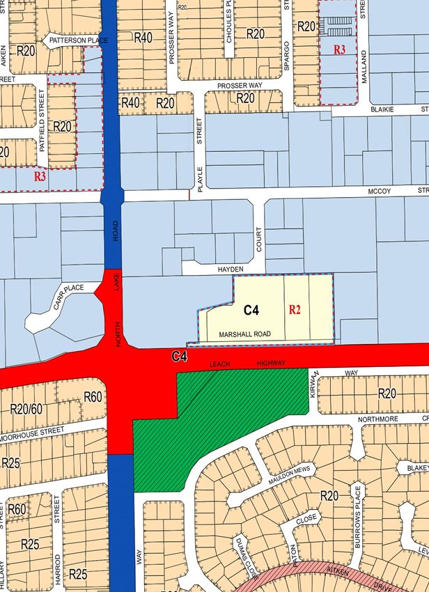
The Marshall Road Local Centre is currently zoned Centre (C4) and classified as Restricted Use (R2) under LPS6.
Surrounding properties north of Leach Highway are zoned Service Commercial under LPS6. Refer Figure 4 –
Existing Zoning (LPS6).
The stated objectives of the ‘Centre C4’ zone under LPS6 are:
• To designate land for future development as a city centre or activity centre.
• To provide a basis for future detailed planning in accordance with the structure planning provisions of this
Scheme or the Activity Centres State Planning policy.
• To provide for a wide variety of active uses on street level which are compatible with residential and other
non-active uses on upper levels.
• To allow for the development of a mix of varied but compatible land uses such as housing, offices, show-
rooms, shops, amusement centres, and eating establishments which do not generate nuisances detrimental
to the amenity of the district or to the health, welfare and safety of its residents.
• To provide for Neighbourhood and Local Centres to focus on the main daily to weekly household shopping
and community needs and focus for medium density housing.
• To ensure that development is not detrimental to the amenity of adjoining owners or residential properties
in the locality.
• To ensure the design and landscaping of development provides a high standard of safety, convenience and
amenity and contributes towards a sense of place and community.
The proposed scheme amendment seeks to remove the Restricted Use (R2) classification which prohibiting nu-
merous land uses that are otherwise permissible under the LPS6 zoning table, consistent with the stated zone
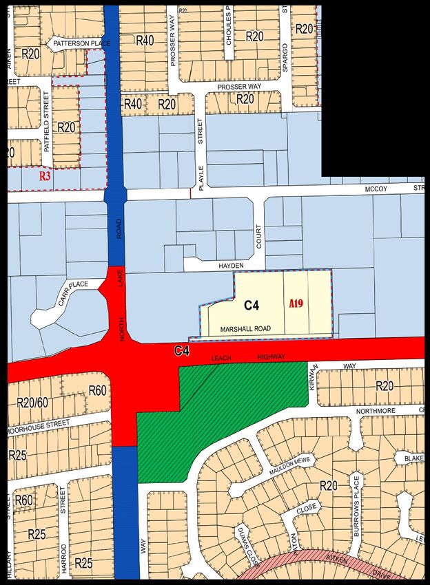
objectives. The proposed Additional Use (A19) classification reflects the site’s unique context and inherent unsuit-
ability for residential/mixed use development. Notably, the zone objectives expressly acknowledge showrooms as
a potentially suitable land use, which in this case (along with Industry – Light, Trade Supplies and Warehouse/Stor-
age) is clearly compatible with surrounding business land uses. There are no residential land uses immediately
adjacent the subject site, hence, no compatibility / nuisance issues with respect to the proposed additional uses.
Refer Figure 5 – Proposed Zoning (LPS6).
12Marshall Road Local Centre
Proposed Amendment to City of Melville Local Planning Scheme No.6
5.2.2 Land Use Permissibility
The Restricted Use (R2) classification under LPS6 designates a strictly limited range of land uses that are permis-
sible on the subject site. The only land uses capable of approval in the Restricted Use (R2) area, as stipulated in
Table 5 of LPS6, are listed as follows:
• Amusement Parlour • Industry – light
• Betting agency • Office
• Child care premises • Recreation – private
• Civic use • Restaurant/café
• Consulting rooms • Service station
• Educational establishment • Shop
• Exhibition centre • Small bar
• Fast food outlet / lunch bar • Warehouse / storage
• Garden centre
The proposed scheme amendment seeks to remove the Restricted Use (R2) classification, effectively defaulting
to the underlying land use permissibility of the Centre (C4) zone, with the proposed Additional Use (A19) classifi-
cation providing for five (5) additional uses that are considered appropriate in this particular location. Each of these
additional uses are discussed in further detail below:
• Bulky Goods Showroom – Bulky Goods Showrooms are permissible in the surrounding Service Com-
mercial zoned area, and were permissible on the subject site (under a ‘Large Format Retail’ land use
classification) prior to the introduction of LPS6. As acknowledged in the City’s strategic planning frame-
work, the Myaree Service Commercial precinct hosts a range of bulky goods retail, convenience retail,
large format retail and light industrial land uses, and in this respect, Bulky Goods Showroom is an
entirely appropriate land use in the context of the subject site. It is also consistent with the Centre (C4)
zone objective to provide a mix of varied but compatible land uses such as showrooms.
• Industry – Light – This land use is already permissible under the land’s Restricted Use (R2) classifica-
tion, and is consistent with the site’s MRS Industrial zoning. It is consistent with the character and
function of the surrounding area, and not considered detrimental to local amenity noting that the LPS6
definition for ‘Industry – Light’ requires that any “impacts on the amenity of the area… can be mitigated,
avoided or managed”.
• Trade Supplies – Trade Supplies is a relatively new land use classification, introduced via the Planning
and Development (Local Planning Schemes) Regulations 2015 and implemented in LPS6. Prior to
LPS6, the sale of tools and equipment used in automotive repairs/servicing, building repair/mainte-
nance and landscape gardening would have typically fallen under a Showroom, Large Format Retail or
other similar land use classification. Trade Supplies activities are consistent with the function/character
of the area (noting that such a classification would apply to the adjacent Bunnings store), and consistent
with the zone objectives to provide a mix of varied and compatible land uses.
• Warehouse / Storage – Like ‘Industry – Light’, the ‘Warehouse / Storage’ land use is already permissible
under the land’s Restricted Use (R2) classification, and is consistent with the site’s MRS Industrial
zoning. It is consistent with the character and function of the surrounding area, particularly noting the
presence of other similar activities in close proximity to the subject site.
5.2.3 Development standards
Development standards currently applicable to the Centre (C4) zone are detailed in Table 7 (Additional site and
development requirements) of LPS6, and address matters including setbacks, building heights, building bulk and
open space. There are no proposed modifications to such standards, which will remain applicable following the
proposed amendment.
13Marshall Road Local Centre
Proposed Amendment to City of Melville Local Planning Scheme No.6
Table 5 of LPS6 identifies the subject site as Restricted Use (R2), with the following condition applicable:
Office and Small Bar Development (including use) may be subject to a specific Scheme provision and/or
policy which may impose restrictions with reference to site suitability criteria, positioning on site or the
amount or proportion of land or floorspace allocated to the particular use.
The proposed scheme amendment would see the site’s Restricted Use (R2) classification removed, along with
the abovementioned condition. The removal of such a condition does not present any particular issues, as the
condition does not impose any specific standards or restrictions, and its deletion does not remove the statutory
head of power to draft separate scheme provisions or policies in any event.
14LEGEND
REGION SCHEME RESERVES
Other Regional Roads
Primary Regional Roads
LOCAL SCHEME RESERVES
Local Distributor Road
Local Road
Public Open Space
LOCAL SCHEME ZONES
Centre
Residential
Service Commercial
OTHER
R20 R Codes
R1 Restricted Uses
SCALE 1: 4,000 @ A4
DATE 22 April 2020 EXISTING ZONING (LPS6) FIGURE
FILE
REVISION
02 200422 6362 Existing Zoning Map.dwg
2/AF/First Draft/22.04.2020
0
Scale Bar (m)
50 100
LOT 801 (208) LEACH HIGHWAY AND
LOT 802 (1) MARSHALL ROAD,
MYAREE, WA
DISCLAIMER: THIS DOCUMENT IS AND REMAINS THE PROPERTY OF PLANNING SOLUTIONS AND MAY NOT BE COPIED IN WHOLE OR IN PART WITHOUT THE WRITTEN CONSENT OF PLANNING SOLUTIONS. ALL AREAS, DISTANCES AND ANGLES ARE APPROXIMATE ONLY AND ARE SUBJECT TO SURVEY. BASEPLAN SOURCE: WAPC
04LEGEND
REGION SCHEME RESERVES
Other Regional Roads
Primary Regional Roads
LOCAL SCHEME RESERVES
Local Distributor Road
Local Road
Public Open Space
LOCAL SCHEME ZONES
Centre
Residential
Service Commercial
OTHER
R20 R Codes
A1 Additional Uses
SCALE 1: 4,000 @ A4
DATE 22 April 2020 PROPOSED ZONING (LPS6) FIGURE
FILE
REVISION
02 200422 6362 Proposed Zoning.dwg
2/AF/First Draft/22.04.2020
0
Scale Bar (m)
50 100
LOT 801 (208) LEACH HIGHWAY AND
LOT 802 (1) MARSHALL ROAD,
MYAREE, WA
DISCLAIMER: THIS DOCUMENT IS AND REMAINS THE PROPERTY OF PLANNING SOLUTIONS AND MAY NOT BE COPIED IN WHOLE OR IN PART WITHOUT THE WRITTEN CONSENT OF PLANNING SOLUTIONS. ALL AREAS, DISTANCES AND ANGLES ARE APPROXIMATE ONLY AND ARE SUBJECT TO SURVEY. BASEPLAN SOURCE: WAPC
05Marshall Road Local Centre
Proposed Amendment to City of Melville Local Planning Scheme No.6
6 Conclusion
On behalf of the landowner of Lot 801 (No. 208) Leach Highway and Lot 802 (No. 1) Marshall Road, Myaree,
Planning Solutions respectfully requests that the City of Melville Local Planning Scheme No. 6 be amended to
expand the range of land uses capable of approval within the Marshall Road Local Centre.
The proposed scheme amendment seeks to remove the Restricted Use (R2) classification currently applicable to
the Marshall Road Local Centre, and replace this with an Additional Use (A19) classification providing for a limited
range of uses that are uniquely appropriate in this location. Such a modification is necessary to ensure commer-
cially viable and contextually appropriate land uses are capable of being approved in this location. The site’s
Centre (C4) zoning will continue to apply consistent with the strategic planning framework and planned activity
centres hierarchy.
We respectfully seek the support of the City, WA Planning Commission and Minister for Planning for the proposed
scheme amendment, having due regard for the provisions of relevant state and local planning frameworks.
16Appendix 1 Certificates of Title
REGISTER NUMBER

                                                                                                                                     801/DP33665
                                                                                                                            DUPLICATE         DATE DUPLICATE ISSUED
                                                                                                                             EDITION
                                                      WESTERN                                     AUSTRALIA                      3               21/3/2013
                                                                                                                                               VOLUME       FOLIO

                                          RECORD OF CERTIFICATE OF TITLE                                                                       2769         266
                                                     UNDER THE TRANSFER OF LAND ACT 1893

   The person described in the first schedule is the registered proprietor of an estate in fee simple in the land described below subject to the
   reservations, conditions and depth limit contained in the original grant (if a grant issued) and to the limitations, interests, encumbrances and
   notifications shown in the second schedule.

                                                                                                            REGISTRAR OF TITLES

                                                                     LAND DESCRIPTION:
   LOT 801 ON DEPOSITED PLAN 33665

                                                               REGISTERED PROPRIETOR:
                                                                   (FIRST SCHEDULE)

   CARROODA PTY LTD OF UNIT 1, 199 ABERNETHY ROAD, BELMONT
   SANSOM NOMINEES PTY LTD OF 5 MILL STREET, PERTH
     AS TENANTS IN COMMON IN EQUAL SHARES
                                                                                                                 (AF L446277 ) REGISTERED 6/10/2010

                                LIMITATIONS, INTERESTS, ENCUMBRANCES AND NOTIFICATIONS:
                                                    (SECOND SCHEDULE)

   1.    C315297     EASEMENT BENEFIT SEE SKETCH ON DEPOSITED PLAN 33665 REGISTERED 4/3/1982.
   2.    C315297     EASEMENT BURDEN SEE SKETCH ON DEPOSITED PLAN 33665. REGISTERED 4/3/1982.
   3.    C601453     EASEMENT BURDEN SEE SKETCH ON DEPOSITED PLAN 33665 REGISTERED 12/8/1983.
   4.    C747811     EASEMENT BENEFIT SEE SKETCH ON DEPOSITED PLAN 33665. REGISTERED 10/4/1984.
   5.    C747811     EASEMENT BURDEN SEE SKETCH ON DEPOSITED PLAN 33665. REGISTERED 10/4/1984.
   6.    D443882     EASEMENT BURDEN SEE SKETCH ON DEPOSITED PLAN 33665 REGISTERED 26/3/1987.
   7.    D443884     EASEMENT BENEFIT SEE SKETCH ON DEPOSITED PLAN 33665. REGISTERED 26/3/1987.
   8.    H519787     EASEMENT BENEFIT SEE SKETCH ON VOL.2199 FOL 578. REGISTERED 7/8/2000.
   9.    H519788     EASEMENT BENEFIT SEE SKETCH ON VOL 2199 FOL 578. REGISTERED 7/8/2000.
   10.   EASEMENT BURDEN CREATED UNDER SECTION 27A OF T. P. & D. ACT - SEE SKETCH ON DEPOSITED
         PLAN 33665 AS CREATED ON DIAGRAM 100373 TO WATER CORPORATION.
   11.   I628559     LEASE TO BUNNINGS BUILDING SUPPLIES PTY LTD OF LEVEL 11, 40 THE ESPLANADE,
                     PERTH EXPIRES: SEE LEASE. REGISTERED 16/9/2003.
   12.   EASEMENT BENEFIT FOR RIGHT OF CARRIAGEWAY PURPOSES. SEE SKETCH ON DEPOSITED PLAN 33665
         AND INSTRUMENT L614021
   13.   EASEMENT BURDEN CREATED UNDER SECTION 136C T.L.A. FOR RIGHT OF CARRIAGEWAY PURPOSES -
         SEE DEPOSITED PLAN 33665 AND INSTRUMENT L614022.
   14.   EASEMENT BURDEN FOR RIGHT OF CARRIAGEWAY PURPOSES. SEE SKETCH ON DEPOSITED PLAN 33665
         AND INSTRUMENT L614023
   15.   EASEMENT BURDEN CREATED UNDER SECTION 136C T.L.A. FOR RIGHT OF CARRIAGEWAY PURPOSES -
         SEE SKETCH ON DEPOSITED PLAN 33665 AND INSTRUMENT L618199
   16.   *M901107    MORTGAGE TO WESTPAC BANKING CORPORATION REGISTERED 2/2/2015.

                                                                END OF PAGE 1 - CONTINUED OVER

LANDGATE COPY OF ORIGINAL NOT TO SCALE 27/02/2020 01:01 PM Request number: 60368578

                                                                                                                                               www.landgate.wa.gov.au
RECORD OF CERTIFICATE OF TITLE
REGISTER NUMBER: 801/DP33665 VOLUME/FOLIO: 2769-266 PAGE 2
Warning: A current search of the sketch of the land should be obtained where detail of position, dimensions or area of the lot is required.
* Any entries preceded by an asterisk may not appear on the current edition of the duplicate certificate of title.
Lot as described in the land description may be a lot or location.
----------------------------------------END OF CERTIFICATE OF TITLE----------------------------------------
STATEMENTS:
The statements set out below are not intended to be nor should they be relied on as substitutes for inspection of the land
and the relevant documents or for local government, legal, surveying or other professional advice.
SKETCH OF LAND: DP33665
PREVIOUS TITLE: 2199-578
PROPERTY STREET ADDRESS: 208 LEACH HWY, MYAREE.
LOCAL GOVERNMENT AUTHORITY: CITY OF MELVILLE
NOTE 1: L578869 SECTION 138D TLA APPLIES TO CAVEAT G686529
NOTE 2: L602302 SECTION 138D TLA APPLIES TO CAVEAT H770766
NOTE 3: DUPLICATE CERTIFICATE OF TITLE NOT ISSUED AS REQUESTED BY DEALING
M901107
LANDGATE COPY OF ORIGINAL NOT TO SCALE 27/02/2020 01:01 PM Request number: 60368578
www.landgate.wa.gov.auREGISTER NUMBER
802/DP33665
DUPLICATE DATE DUPLICATE ISSUED
EDITION
WESTERN AUSTRALIA 4 11/12/2013
VOLUME FOLIO
RECORD OF CERTIFICATE OF TITLE 2769 267
UNDER THE TRANSFER OF LAND ACT 1893
The person described in the first schedule is the registered proprietor of an estate in fee simple in the land described below subject to the
reservations, conditions and depth limit contained in the original grant (if a grant issued) and to the limitations, interests, encumbrances and
notifications shown in the second schedule.
REGISTRAR OF TITLES
LAND DESCRIPTION:
LOT 802 ON DEPOSITED PLAN 33665
REGISTERED PROPRIETOR:
(FIRST SCHEDULE)
CARROODA PTY LTD
SANSOM NOMINEES PTY LTD
BOTH OF PO BOX 447 WELSHPOOL DC WA 6986
AS TENANTS IN COMMON IN EQUAL SHARES
(AF L446277 ) REGISTERED 6/10/2010
LIMITATIONS, INTERESTS, ENCUMBRANCES AND NOTIFICATIONS:
(SECOND SCHEDULE)
1. C315297 EASEMENT BENEFIT SEE SKETCH ON DEPOSITED PLAN 33665 REGISTERED 4/3/1982.
2. C315297 EASEMENT BURDEN SEE SKETCH ON DEPOSITED PLAN 33665. REGISTERED 4/3/1982.
3. C601453 EASEMENT BURDEN SEE SKETCH ON DEPOSITED PLAN 33665 REGISTERED 12/8/1983.
4. C747811 EASEMENT BENEFIT SEE SKETCH ON DEPOSITED PLAN 33665. REGISTERED 10/4/1984.
5. C747811 EASEMENT BURDEN SEE SKETCH ON DEPOSITED PLAN 33665. REGISTERED 10/4/1984.
6. *G459925 LEASE TO HUNGRY JACK'S PTY LTD OF BUILDING A, THE GARDENS OFFICE PARK, 255
SCARBOROUGH BEACH ROAD, OSBOURNE PARK AS TO PORTION ONLY. EXPIRES: SEE
LEASE. REGISTERED 29/4/1997.
*M428629 EXTENSION OF LEASE G459925. REGISTERED 11/10/2013.
*M428629 THE ADDRESS OF THE LESSEE IS NOW LEVEL 1, BUILDING A, THE GARDEN OFFICE
PARK, 255 SCARBOROUGH BEACH ROAD, OSBORNE PARK REGISTERED 11/10/2013.
*N568521 EXTENSION OF LEASE G459925. REGISTERED 3/3/2017.
*N568521 THE ADDRESS OF THE LESSEE IS NOW OF LEVEL 6/100 WILLIAM STREET
WOOLLOOMOOLOO NEW SOUTH WALES 2011 REGISTERED 3/3/2017.
7. H519787 EASEMENT BENEFIT SEE SKETCH ON VOL.2199 FOL 578. REGISTERED 7/8/2000.
8. H519788 EASEMENT BENEFIT SEE SKETCH ON VOL 2199 FOL 578. REGISTERED 7/8/2000.
9. EASEMENT BURDEN CREATED UNDER SECTION 136C T.L.A. FOR RIGHT OF CARRIAGEWAY PURPOSES -
SEE DEPOSITED PLAN 33665 AND INSTRUMENT L614020.
*M938539 EASEMENT L614020 PARTIALLY SURRENDERED. SEE DEPOSITED PLAN 70870
REGISTERED 13/3/2015.
10. EASEMENT BURDEN FOR RIGHT OF CARRIAGEWAY PURPOSES. SEE SKETCH ON DEPOSITED PLAN 33665
AND INSTRUMENT L614021
END OF PAGE 1 - CONTINUED OVER
LANDGATE COPY OF ORIGINAL NOT TO SCALE 27/02/2020 01:01 PM Request number: 60368578
www.landgate.wa.gov.auRECORD OF CERTIFICATE OF TITLE
REGISTER NUMBER: 802/DP33665 VOLUME/FOLIO: 2769-267 PAGE 2
11. EASEMENT BENEFIT FOR RIGHT OF CARRIAGEWAY PURPOSES. SEE SKETCH ON DEPOSITED PLAN 33665
AND INSTRUMENT L614023
12. *M901107 MORTGAGE TO WESTPAC BANKING CORPORATION REGISTERED 2/2/2015.
13. *N058067 LEASE TO AUSTRALIAN LIQUOR GROUP LTD OF 800 TOORAK ROAD HAWTHORN EAST
VICTORIA EXPIRES: SEE LEASE. AS TO PORTION ONLY. REGISTERED 10/7/2015.
14. *N096138 LEASE TO THE CHEESECAKE SHOP (WA) PTY LTD OF 2 LISBON STREET VILLAWOOD NEW
SOUTH WALES EXPIRES: SEE LEASE. AS TO PORTION ONLY. REGISTERED 19/8/2015.
15. *N134142 LEASE TO ZAMBRERO PROPERTY GROUP PTY LTD OF LEVEL 24/1 ALFRED STREET SYDNEY
NEW SOUTH WALES EXPIRES: SEE LEASE. AS TO PORTION ONLY REGISTERED 29/9/2015.
16. *O009503 LEASE TO 8T8 BROADWAY PTY LTD OF SHOP 39 88 BROADWAY NEDLANDS WA EXPIRES:
SEE LEASE. AS TO PORTION ONLY REGISTERED 17/10/2018.
17. *O155684 CAVEAT BY DOMINO'S PIZZA ENTERPRISES LIMITED AS TO PORTION ONLY LODGED
21/5/2019.
Warning: A current search of the sketch of the land should be obtained where detail of position, dimensions or area of the lot is required.
* Any entries preceded by an asterisk may not appear on the current edition of the duplicate certificate of title.
Lot as described in the land description may be a lot or location.
----------------------------------------END OF CERTIFICATE OF TITLE----------------------------------------
STATEMENTS:
The statements set out below are not intended to be nor should they be relied on as substitutes for inspection of the land
and the relevant documents or for local government, legal, surveying or other professional advice.
SKETCH OF LAND: DP33665
PREVIOUS TITLE: 2199-578
PROPERTY STREET ADDRESS: 1-7 MARSHALL RD, MYAREE.
LOCAL GOVERNMENT AUTHORITY: CITY OF MELVILLE
NOTE 1: L578869 SECTION 138D TLA APPLIES TO CAVEAT G686529
NOTE 2: L602302 SECTION 138D TLA APPLIES TO CAVEAT H770766
NOTE 3: M875782 DEPOSITED PLAN (INTEREST ONLY) 70870 LODGED
NOTE 4: DUPLICATE CERTIFICATE OF TITLE NOT ISSUED AS REQUESTED BY DEALING
M901107
LANDGATE COPY OF ORIGINAL NOT TO SCALE 27/02/2020 01:01 PM Request number: 60368578
www.landgate.wa.gov.auREGISTER NUMBER
35/D61855
DUPLICATE DATE DUPLICATE ISSUED
EDITION
WESTERN AUSTRALIA N/A N/A
VOLUME FOLIO
RECORD OF CERTIFICATE OF TITLE 1774 965
UNDER THE TRANSFER OF LAND ACT 1893
The person described in the first schedule is the registered proprietor of an estate in fee simple in the land described below subject to the
reservations, conditions and depth limit contained in the original grant (if a grant issued) and to the limitations, interests, encumbrances and
notifications shown in the second schedule.
REGISTRAR OF TITLES
LAND DESCRIPTION:
LOT 35 ON DIAGRAM 61855
REGISTERED PROPRIETOR:
(FIRST SCHEDULE)
MCDONALD'S PROPERTIES (AUSTRALIA) PTY LTD OF 33 WATERLOO ROAD, NORTH RYDE, NEW SOUTH
WALES
(A D527942 ) REGISTERED 30/7/1987
LIMITATIONS, INTERESTS, ENCUMBRANCES AND NOTIFICATIONS:
(SECOND SCHEDULE)
1. C747811 EASEMENT BENEFIT SEE SKETCH ON VOL 1774 FOL 965. REGISTERED 10/4/1984.
2. C315297 EASEMENT BENEFIT SEE SKETCH ON VOL 1774 FOL 965. REGISTERED 4/3/1982.
3. C315297 EASEMENT BURDEN SEE SKETCH ON VOL 1774 FOL 965. REGISTERED 4/3/1982.
4. C601453 EASEMENT BURDEN SEE SKETCH ON VOL 1774 FOL 965. REGISTERED 12/8/1983.
5. C747811 EASEMENT BURDEN SEE SKETCH ON VOL 1774 FOL 965. REGISTERED 10/4/1984.
Warning: A current search of the sketch of the land should be obtained where detail of position, dimensions or area of the lot is required.
* Any entries preceded by an asterisk may not appear on the current edition of the duplicate certificate of title.
Lot as described in the land description may be a lot or location.
----------------------------------------END OF CERTIFICATE OF TITLE----------------------------------------
STATEMENTS:
The statements set out below are not intended to be nor should they be relied on as substitutes for inspection of the land
and the relevant documents or for local government, legal, surveying or other professional advice.
SKETCH OF LAND: 1774-965 (35/D61855)
PREVIOUS TITLE: 1664-780
PROPERTY STREET ADDRESS: 9 MARSHALL RD, MYAREE.
LOCAL GOVERNMENT AUTHORITY: CITY OF MELVILLE
LANDGATE COPY OF ORIGINAL NOT TO SCALE 27/02/2020 01:01 PM Request number: 60368578
www.landgate.wa.gov.auREGISTER NUMBER
36/D61855
DUPLICATE DATE DUPLICATE ISSUED
EDITION
WESTERN AUSTRALIA 3 23/4/2008
VOLUME FOLIO
RECORD OF CERTIFICATE OF TITLE 1774 966
UNDER THE TRANSFER OF LAND ACT 1893
The person described in the first schedule is the registered proprietor of an estate in fee simple in the land described below subject to the
reservations, conditions and depth limit contained in the original grant (if a grant issued) and to the limitations, interests, encumbrances and
notifications shown in the second schedule.
REGISTRAR OF TITLES
LAND DESCRIPTION:
LOT 36 ON DIAGRAM 61855
REGISTERED PROPRIETOR:
(FIRST SCHEDULE)
SUMMIT DEVELOPMENT CORPORATION PTY LTD OF 242 LEACH HIGHWAY, MYAREE
(AN K561308 ) REGISTERED 9/4/2008
LIMITATIONS, INTERESTS, ENCUMBRANCES AND NOTIFICATIONS:
(SECOND SCHEDULE)
1. C315297 EASEMENT BENEFIT REGISTERED 4/3/1982.
D527943 EASEMENT MODIFIED BY SURRENDER D527943. REGISTERED 1/1/1987.
2. C315297 EASEMENT BURDEN SEE SKETCH ON VOL 1774 FOL 966. REGISTERED 4/3/1982.
3. D394950 MORTGAGE TO NATIONAL AUSTRALIA BANK LTD REGISTERED 9/1/1987.
Warning: A current search of the sketch of the land should be obtained where detail of position, dimensions or area of the lot is required.
* Any entries preceded by an asterisk may not appear on the current edition of the duplicate certificate of title.
Lot as described in the land description may be a lot or location.
----------------------------------------END OF CERTIFICATE OF TITLE----------------------------------------
STATEMENTS:
The statements set out below are not intended to be nor should they be relied on as substitutes for inspection of the land
and the relevant documents or for local government, legal, surveying or other professional advice.
SKETCH OF LAND: 1774-966 (36/D61855)
PREVIOUS TITLE: 1613-60
PROPERTY STREET ADDRESS: 11 MARSHALL RD, MYAREE.
LOCAL GOVERNMENT AUTHORITY: CITY OF MELVILLE
LANDGATE COPY OF ORIGINAL NOT TO SCALE 27/02/2020 01:01 PM Request number: 60368578
www.landgate.wa.gov.auYou can also read


