Local Hiking Trails - Emerson Resort & Spa
←
→
Page content transcription
If your browser does not render page correctly, please read the page content below
Local Hiking Trails
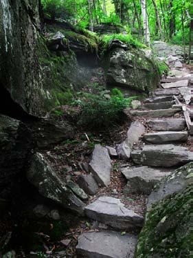
Walking Paths Along Esopus Creek / Emerson Meadows
Please enjoy a moment taking in the surrounding nature. We have a small
viewing pond and there is a path along the Mt. Pleasant Road spillway from
which to watch the Esopus Creek. You can follow the road down to the old
bridge over the Esopus. There are a few paths down to the creek for exploring.
Our property also features many acres of rolling meadows for hiking and
exploring. The Woodland Trail, which starts near the Ralph’s Café outdoor
patio, passes through a pine grove on its way to our sporting fields.

                                                               Esopus Creek

Maurice Hinchey Catskill Interpretive Center
The Interpretive Center is a new facility providing stewardship and information
about the Catskill Mountains. There is a sculpture art park and they have many
displays for regional education, history, and conservation. Inside you can see
an impressive 3D projected topographic model of our Catskill Mountains.
Venturing outside of the Center, you will find a short series of simple trails.
There is also a short network of well-maintained walking paths through the
surrounding woods, including two loop trails – The Old Field Trail and the
Winnie Farm History Trail. Both are flat and easy to walk. The New York-New
Jersey Trail Conference completed a new trail up the hill behind the Catskill
Interpretive Center. It is a half mile hike up the trail to a picnic area with views
of Mount Pleasant and the Esopus Creek. You’ll also find a path that leads
across Route 28 and through the woods to a public fishing and scenic area on
the Esopus. Open from 9AM-4:30PM. Turn left out of parking lot, Center is 1.5
miles on the left.

Ashokan Reservoir
The Ashokan Reservoir is a beautiful and functional body of water formed by
the damming of the Esopus Creek. Consisting of two basins separated by a
concrete dividing weir and roadway, it holds 122.9 billion gallons at full
capacity and was placed into service in 1915. Including the water it receives
from the Schoharie Reservoir, the Ashokan supplies about 40% of New York
City’s daily drinking water needs in non-drought periods. Water enters the
Ashokan’s West Basin and, after a settling period, is withdrawn from its East
Basin. It is carried southeast under the Hudson River via the 92-mile Catskill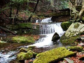
Aqueduct, which has a maximum depth of 1,114 feet.
 There are two Reservoir Promenades that have exceptional views of the reser-
voir and the mountains and are popular among walkers, runners, cyclists, and
bird watchers. The first promenade begins at terminus of a circular
cul-de-sac, locally known as “the Frying Pan.” The open, paved path runs
westerly along the edge of the reservoir for approximately 1.25 miles. Here it
ends to allow vehicular traffic to pass from Reservoir Road along a NYC Board
of Water Supply Road to Route 28-A. The second promenade begins
immediately west of the intersection with Reservoir Road and continues for
approximately 1.35 miles where it terminates at a parking area and the
junction with Route 28-A. This promenade goes along the reservoir and then
enters a wooded section passing a monument dedicated to J. Waldo Smith,
engineer of the New York City water supply system. The former road continues
across a dam under which water can be released into the no-longer-dammed
Esopus Creek. The Dividing Weir, atop which Reservoir Road crosses the reser-
voir, functions to abate sedimentation that occurs in waters that enter the upper
reservoir basin. The weir slows the flow between the basins so that the
sediment is allowed to settle before the less turbid water is released from the
lower basin to begin its journey to the taps of New York City. The dividing weir
offers spectacular views of the reservoir and the backdrop of forested
mountains. The Spillway, seen from Route 28-A near the junction with Stone
Church Road, allows water to exit the reservoir as it exceeds capacity. Stone
Church Road leads to Beaverkill Road which crosses the Spillway Gorge, a
long rock canyon that enables water to pass from the Spillway to the Esopus
Creek. Turn left out of the parking lot, after 7.5 miles, turn right onto
Reservoir Rd. Follow Reservoir Road to its end over the bridge, and then make
a left. After ¼ mile, turn left onto Route 28A. The next left will lead to the park-
ing area.

Kenneth Wilson Public Campground
Located in the mountainous heart of the Central Catskills in the shadow of Tice-
tonyk Mountain and features more than a handful of pretty nature views. The
campsite also offers a beach and canoe rentals. There are broad activity fields
on the grounds that make for great star gazing locations at night. The camp-
ground was once several farms. The land was purchased in the 1960’s and the
campground was opened on June 29, 1979.

 There are four marked hiking loop trails, including one that will take you past
a beaver pond. There are also a few unmarked trails for a more adventurous
outing. The frontside of the park has manicured lawns and a picnic area, while
the wilder backside is marked by wetlands and wooded stands. There is an
ADA accessible portion of the trail that leads to a floating dock overlooking
Wilson Lake. There are many old stone walls lacing the park, giving it an air of
history and mystery. 859 Wittenberg Road, Mt. Tremper, NY 12457
Turn left out of parking lot and go .5 miles to left on Route 212, then .5 miles to
right on Route 40. Park is 4 miles on right.

Comeau Property - A Walk in the Park!
This idyllic park is just steps from the center of Woodstock. There are
rolling meadows, athletic fields, and a pair of exquisite nature trails. Start at the
upper parking lot and follow a well-worn path down the meadow to the David
Corbett Trail. Corbett designed and implemented this scenic path through
hardwood stands and along the SawKill Creek, including a wooden boardwalk
made from planks of the famous Coney Island Boardwalk! Continue on the
West Trail for more views of the creek. There are many places to have a picnic
and enjoy the peace. Easy walking trails total an approximate 1.5 mile loop
back to the parking lot. Turn left out of parking lot. Go 13.5 miles to left on
Route 375. Drive 3 miles to the end of Route 375 and turn left onto Mill Hill
Road. Drive through Woodstock, bearing left onto Tinker Street. Turn left onto
Comeau Drive after .2 miles.

Onteora Lake – A Place to Picnic, Fish, and Hike
7.1 miles with 3 loops. 885 ft elevation change.
This gem is easy to miss with its understated entrance off of Route 28, but you
will be glad you found it once you take in the picturesque lake. There are a few
picnic spots that invite you to drop a line into the warm shallow lake. Bypass
the parking lot by the road and drive down to the lower lot. From here there is
an ADA accessible path that will parallel the lake. The path gets a little rougher
once you are past the lake, but there isn’t too much elevation change. The old
woods road connects to three trail loops (1.1 miles to the first yellow loop)
through upland oaks, moist hemlock forests, and many abandoned bluestone
quarries. The yellow trail loop is highly recommended as it passes by the
beautiful and peaceful Pickerel Pond before returning to the beginning of the
trail (look for the old car wreck and try to imagine how it got there!) The red
trail loop ascends a ridge with 2 large vernal pools and upland forest with
scattered pitch pines (2.25 miles), and the blue trail loop traverses some
relatively rough mixed topography (1.5 miles). These trails are maintained by
the local Fats in the Cats bike club and are perfect for mountain biking. Turn
left out of the parking lot and drive 15 miles to entrance on left just after a row
of businesses. There is an unmarked trail from the first lot or park at the lower
lot closer to the lake.

Onteora Lake
Overlook Mountain
4.7 mile round trip. 1,410 ft elevation gain.
 A wide gravel trail climbs steadily to the top of Overlook Mountain following
an old carriage road that once transported guests in the late 19th century to the
Overlook Mountain House. There are nice views through the trees on the way
up. At 1.6 miles you see the massive castle-like ruins of the never-completed
Overlook Mountain House (elevation 2,900 feet), begun in the 1920’s, and now
being reclaimed by nature. Nearby is a privately-owned tower for which the
carriage road is maintained. The Overlook Road trail makes a left and continues
1.8 miles down to the peaceful Echo Lake. The red trail leads to the fire tower at
3,150 ft. The spur trail to the right of the ground cabin takes you to a ledge with
a magnificent view of the Hudson River, Ashokan Reservoir, the Central Catskills,
and up to five states. Ledges and drop-offs require care. One-way distance is 2.4
miles. Ascent is a gradual but nonstop incline of 1370 feet. Turn left out of park-
ing lot. Go 13.5 miles to left on Route 375. Drive 3 miles to the end of Route 375
and turn left onto Mill Hill Rd. Drive into Woodstock and then turn right onto
Rock City Road. After .5 miles, the road will cross Glasko Turnpike and become
Meads Mountain Road. Continue up the road for 2 miles to the trailhead on the
right.

Sloan Gorge Preserve – Geology Classroom in the Woods
This intriguing and lovely slice of the Catskills eastern escarpment is the gift of
the family of Woodstock artist Allan Edward Sloan. Perhaps most notable for its
highly visible and tangible geology, Sloan Gorge also boasts scenic,
botanical and zoological wonders. Located at the foot of Overlook Mountain
on the Woodstock-Saugerties town line, the 88-acre Preserve is a treasure trove
of mixed hardwood and coniferous forests, vernal pools, a seasonal stream, and
bluestone quarries, and has the first interpretive “geology trail” in the area. The
1.75 mile loop trail is mostly easy with a few glacial features to explore. Sloan
Gorge was carved by glacial meltwaters cascading off the flank of
Overlook Mountain and the Catskill Front, flowing north-northeast to
south-southwest through the gorge. This deeply entrenched gorge, while mostly
dry today, preserves an important chapter in the recent geologic history of the
Catskills region. Robert Titus provides an excellent interpretive geology trail de-
scription of the gorge, which has been correlated with numbered markers along
the trail. Turn left out of parking lot. Go 13.5 miles to left on Route 375. Drive 3
miles to the end of Route 375 and turn left onto Mill Hill Road. Drive into Wood-
stock and turn right onto Rock City Road and drive .6 miles, then turn right on
Glasco Turnpike. Go 1.7 miles and then turn left on West Saugerties Road. After
1.1 miles, turn right on Goat Hill Road. Bear right at the corner again for .1 miles
to Stoll Road. Turn left on Stoll Road. After .2 miles you’ll see the Woodstock
Land Conservancy kiosk on the left.
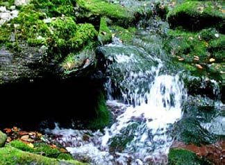
Becker Hollow Falls
Drops over 8 feet in two sections near the entrance to an old farmstead. Hike
the .4 mile blue blazed Becker Hollow Trail, which passes between two stone
pillars (the remnants of a stone arch) and continues on a woodsy road through
a young forest (formerly the Becker family farm). The trail is nearly level,
paralleling a cascading stream on the right. After crossing the stream on a
wooden footbridge, the trail passes an old concrete dam above the falls. There
are several paths leading from the trail to the falls. The main trail continues very
steeply up to the summit of Hunter Mountain. Turn right out of the parking lot
and go 3 miles, then turn right onto Route 214. After .2 miles, turn left to stay
on Route 214. Go 10.7 miles to parking for Becker Hollow Trail on left.
Becker Hollow Falls
Giant Ledge
1.6 miles, 3.2 miles round trip, 1,100 ft elevation gain
An excellent moderate hike with incredible views. This is one of the shorter
hikes to a view, although sections are steep, and the footing can be rough. In
only 1.5 miles, you will climb up and over rock scrambles to the Giant Ledge
and a series of amazing vistas. The west side of the ridge has the typical smooth
rounded shape caused by glacial action and years of erosion, but the east side
provides panoramic views of the northern and southern Catskills, as well as the
Esopus Valley and forest canopy below. There is actually a series of ledges. The
viewpoints sit atop a sheer cliff dropping to the forest floor 180 feet below. You
can continue down the other side of Giant Ledge and up and along the Panther
Mountain ridge to extend the hike. The trail starts at the hair-pin turn on Route
47 and follows the yellow blazed Phoenicia East Branch Trail to a left on to the
Blue Blazed Panther Mountain Trail. Turn right out of the parking lot and drive
11 miles before turning left onto Oliverea Road (Route 47). The parking area is
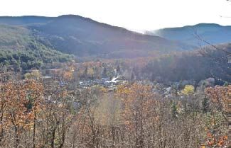
7.5 miles up on the right.Tan Bark Trail Tan Bark Trail – Interpretive History Trail overlooking Phoenicia 2.3 mile loop. 800 ft elevation change. Blue Blazes (blue trail markers) The Tan Bark Trail is a good short hike. This hike does have some challenging sections, especially near the beginning, but you are rewarded with great viewpoints overlooking the town of Phoenicia. The 2.3-mile loop hike follows portions of a historic tan bark trail and various old quarry roads that once provided access to bluestone quarries and hemlock trees back in the 1800’s. Interpretive signage along the route tells the story. The hike has several short, very steep inclines/declines with an overall elevation gain of 800 ft. Meet the trailhead by the playground equipment in the Parish Field just off Main Street in Phoenicia. Turn right out of Emerson parking lot. Proceed for 2.5 miles and turn right to follow the large sign into town. At the intersection with Main Street, turn right and park on the road. Proceed back to intersection on foot and follow Mt Ava Maria Drive walking past the grocery store and library (on left). The park is on the right after the post office. Bastion Falls Bastion Falls is the most accessible and most prominent waterfall in Kaaterskill Clove, dropping 71 feet in two steps along Lake Creek adjacent to where Route 23A makes a horseshoe curve at the trail to Kaaterskill Falls. Parking is available at the Molly Smith parking area on the south side of Route 23A.
Kaaterskill Falls
Kaaterskill Falls is a two-tier waterfall that totals a 231 ft drop, the upper tier
falling 167 feet and the lower 64 feet. The falls are one of America’s oldest
tourist attractions, appearing in some of the most prominent books, essays,
poems and paintings of the early 19th century. Beginning with Thomas Cole’s
first visit in 1825, the falls became an iconic subject for painters of the Hudson
River School, setting the wilderness ideal for American landscape painting.
Like most of the rest of the waterfalls in Kaaterskill Clove, the drainage area
above Kaaterskill Falls is fairly limited and while the falls do flow year round
there is a significant reduction in the volume of water present in Lake Creek
during the dry season. Access the trail from the Molly Smith parking area on
the south side of Route 23A. The trail head is located 0.2 miles down the road
from the parking area. From the trailhead it is 0.5 miles to the waterfall. There
is a moderate climb for the first 250 feet, then the trail levels off to a gentle
climb following the creek. DEC contractors recently completed a new foot trail
leading from the end of the marked Kaaterskill Falls trail at the base of the falls
upslope to the middle pool of the falls, which included installation of a new
stone staircase. The trail was also extended from the middle pool to the
Escarpment trail creating a key linkage between the top and the bottom of the
falls, allowing hikers to avoid a potentially dangerous bushwhack between the
two locations. The top of Kaaterskill Falls is also accessible from the end of
Laurel Road. There is a parking lot and a fully accessible trail leading to a new
overlook platform at the top of the falls. These features improve the public’s
view of the falls from the top and enhance safety by directing people to a safe
viewing area away from the top of the falls.

Hiking Advisory: Please DO NOT stray from the designated paths. Alongside
its beauty, Kaaterskill Falls can be extremely dangerous and has taken the lives
of many overzealous hikers over the years. When hiking this popular waterfall,
it’s important to always take precautions. Never attempt to hike beyond the end
of the designated hiking trail and do not try to hike any portion of the water-
fall itself on either tier. The bedrock is very exposed and eroded causing very
dangerous conditions. Turn right out of the parking lot and go 3 miles, then
turn right onto Route 214. After .2 miles, turn left to stay on Route 214. Go 12
miles to the end of Route 214 and turn right onto Route 23A. Drive 6 miles to
parking on right.

Huckleberry Point
5 miles out and back.
Huckleberry Point perches at the northeast corner of Platte Clove in the shad-
ow of 3,655-ft Kaaterskill High Peak. True to its name, huckleberry bushes cov-
er the area and in the fall produce a bumper crop of sweet berries. The trail fol-
lows the route up to Kaaterskill High Peak until a side trail to the right, marked
with informal red and white discs, heads to the east. Tunnels of mountain laurel
line the route, hemming in the trail and giving the area a lush appearance year-
round. Once out on the open ground of Huckleberry Point, the views stretch
to the south and east. The deep, steep clove is a marked contrast with the high,
steep slopes of Indian Head and Plattekill mountains. Turn right out of the
Emerson parking lot and go 3 miles, then turn right onto Route 214. After .2
miles, turn left to stay on Route 214. Go 12 miles to the end of Route 214 and
turn right onto Route 23A. After .6 miles, turn right onto Bloomer Road. Bear
left onto Platte Clove Road after 1.1 miles. Drive 5 miles and the parking will
be on your left.

Ashokan High Point – Kenape Brook
7 miles round trip, red markers, 2,000 foot elevation gain
This trail follows an old woods road with a gradual incline along scenic
Kanape Brook then ascends more steeply on a footpath with rocky sections to
the summit of Ashokan High Point. Along Kanape Brook, you can see the
remnants of hillside farms on what was once known as Freeman Avery Road.
The trail leaves the old road at 2.65 miles, continuing up to Ashokan High
Point Mountain (3,080 ft). The climb is intense but rewarding. At the summit,
there are anchor bolts in the rock where an old tower once stood. There are
seasonal views and a series of clearings with fire rings and views of the
Burrough’s Range. There is an abundance of wild blueberries on the
summit, due to repeated burning. If you are adventurous, you can bushwack
east following the ridge to the lower summit - sometimes called Little High
Point for open views of the Rondout Valley. There is a field of large, beautiful,
and mysterious cairns about 1.5 miles from the trailhead. Turn left out of the
parking lot and drive 3.5 miles through Boiceville before turning right onto
Route 28A. After 3 miles, turn right onto Route 42. The parking area is 4 miles
up on the right.

Rochester Hollow – Yesterday’s Estate Returns to Nature
3.9 miles with 2 side loops. 1,250 ft elevation change.
This parcel was the former estate of Colonel William Rochester, who purchased
small farms in the area to create a large estate. The trail is an old road that once
connected to Rose Mountain Road, and it parallels the stream north for nearly
2 miles before making a sharp turn west for the remaining 0.75-mile. This
gently sloping trail is great for families looking for a shorter, moderate hike.
Travel back into time as you hike 3.5 miles and 850 feet to the high point on
the old woods road, a marvel of engineering with old stone walls and
culverts, carved out of the side of Rose Mountain. The monument dedicated to
19th-century Catskills naturalist John Burroughs was erected in 1921. There are
two scenic side trails for further exploration and leaf peeping. The Burroughs
Memorial Forest trail winds through a series of tall and stately stone fences,
intricately constructed by long-ago engineers. A little more than half a mile
beyond the Burroughs monument are the remains of the Rochester estate. Just
beyond, in an open pole stand, is a nicely kept lean-to, a great place for lunch.
Following the Eignor Farm trail, look for an old meadow guarded by a giant
sugar maple and gorgeous red oak grove and some interesting stone founda-
tions from the Eignor Farm. Turn right out of the parking lot and drive 12 miles
to Matyas Road. Turn right and park at the end of the road.
Diamond Notch Trail / Waterfall – Lover’s Glen
2.8 miles. 550 ft elevation change.
This hike begins at the eastern end of the high-walled Spruceton Valley, at the
end of Greene County Route 6. The valley can be accessed only from the west,
and the long drive into the glacially carved landscape is scenic. The dwindling
waters of the West Kill parallel the road’s dwindling width. The road ends
at a small parking area and then continues as the foot trail. This trail is very
old. The trail first existed for the Mohawk Indians who used it to travel from
valley-to-valley. Later on a new road was built on the east side that was higher
up on the mountain side. This is the road that the trail is now on. Water often
rushes over and through the rocky surface of the short trail. Almost every bend
in the trail and stream brings a new and stunning streamscape. Dark hemlocks
are common alongside the lively stream. Diamond Notch Falls is a small,
graceful 15-foot waterfall accompanied by a whitewater cascade. Both are
nestled in a small canyon. A short, steep drop from the trail ends at a spot per-
fect for contemplation. The course of the falls was drastically altered by Trop-
ical Storm Irene in 2011. Before the storm, the main course flowed from the
right outlet, but it has since moved over to the left side. Continue on the Blue
Blazed trail up past a lean to on your left before arriving at the actual Diamond
Notch between Hunter and West Kill Mountain. There is a viewpoint about .15
miles past the notch. Turn right out of the parking lot and drive 8 miles to right
onto Route 42. Drive 7.3 miles to Spruceton Road and turn right. Go another
7.4 miles all the way to the last parking lot.

                                                 Diamond Notch Trail
Spruceton Trail - Hunter Mountain Tower Loop
8 mile loop. 2,200 ft elevation change.
This loop hike climbs to the second-highest peak in the Catskills, with
outstanding views from the fire tower at the summit and from several other
viewpoints along the trail. The fire tower is open to the public, and it affords
excellent views in all directions. The trail climbs moderately from the
Spruceton Trail along a jeep road to the summit and then follow’s the notori-
ous Devil’s Path back down to the Diamond Notch Trail, past the waterfall and
back out to Spruceton Road. There is plenty of varied topography here, from
narrow through thick spruce-fir forest at the higher elevations, to stony terrain
through stands of maple and beech trees. Turn right out of the parking lot and
drive 8 miles to right onto Route 42. Drive 7.3 miles to Spruceton Road and
turn right. Go another 7.1 miles to the Hunter Mountain parking lot on the left.
Tremper Mountain - Phoenicia Fire Tower
2.75 miles one way. 2,000 elev change. Red blazes. (Red Trail Markers)
Tremper Mountain is a nice hike up the old jeep trail to the Fire Tower. The
hike immediately climbs 100 feet up the stairs made out of rocks. After 0.3
miles, you will be joined with the old jeep trail to the Tremper Mountain Fire
Tower. The trail is a continuous climb, going past the Baldwin Memorial
Lean-to at 1.95 miles and a pipe spring at 2.2 miles. There is a Rattlesnake den
about 100 feet off the trail in the old bluestone quarry at 1.5 miles (elevation
1,450 ft). The Fire Tower at 2,740 ft was built in 1917, and used up until 1971.
The tower was restored and opened to the public in 2001 and is 47 feet high.
Turn left out of the parking lot and go .5 miles and turn left on Route 212. After
another .5 miles, turn left onto County Road 40 (Plank Road). The trailhead is
2.5 miles up on the right.
Mount Tremper Fire TowerPlateau Mountain - Orchard Point
2.8 miles out and back. 1,900 ft elevation change.
Red Blazes. (Red Trail Markers)
Park at the serene and beautiful Notch Lake at Stony Clove to explore this steep
and challenging section of The Devil’s Path. Stony Clove Notch is a narrow
mountain pass with rugged visual appeal. The route follows the Devil’s Path as
it heads east out of Stony Clove. The trail is a very steep rise out of Stony Clove
Notch to a long, level plateau with isolated views. The ascent from Devil’s
Tombstone is one of the quickest and steepest in the Catskills. The Orchard is
a grandiose viewpoint located on Plateau Mountain’s western face. The hike is
short—only a little more than a mile—but the trail rises more than 1,500 feet,
making it one of the steepest ascents in the Catskill Mountains. A cool breeze
is common, adding the refreshing scent of balsam to the air. The view is out-
standing and expansive. You can take in both Belleayre and Hunter Mountain
ski areas in one glance! A second viewpoint of Kaaterskill High Peak and the
Platte Clove can be found just 5 minutes further on the trail. The trail actually
goes across the long flat summit of Plateau Mountain to a junction with the
Warner Creek Trail on Daley Ridge and then continues on the Devil’s Path.
Stony Notch Falls
This hidden waterfall is a series of cascades formed in a small notch on the
southwest slope of Plateau Mountain. There are multiple narrow falls falling
over 15 feet that can be explored by a rock scramble. Start on the red blazed
Devil’s path, and after .15 miles, veer off to the right and follow the sound of
falling water over and up into the notch.
Notch Lake
Notch Lake is a small artificial lake in the Devil’s Pass between Hunter and
Plateau Mountains. It is the beginning of the Stony Clove Creek, and was
historically referred to as Stygian Lake, which was the mythological headwaters
of the River Styx. It is one of the few places in the Catskills where there is a
patch of Boreal Forest growing below 3,000 feet above sea level. A fire
occurred near the northern shore in the 1990’s. There is a parking area and a
site for a picnic/barbeque. Turn right out of the parking lot and go 3 miles, then
turn right onto Route 214. After .2 miles, turn left to stay on Route 214. Go 9
miles to parking on left. Trailhead is on right.
Notch LakeMount Romer – Mt. Pleasant – Mt. Cross
9.5 miles one way. 1,350 ft elevation gain. Blue Blazes. (Blue Trail Markers)
The new section of the Long Path is a 9.5-mile stretch of trail connecting the
village of Phoenicia to the Burroughs Range Trail, crossing three Catskill
mountains: Romer, Pleasant, and Cross. The trail gains its elevation with
switchbacks in small shorter steep sections, with plenty of level terrain. The
trail builders’ stonework is quite impressive, and their constructed stairs make
the trail much easier. There are a few limited views of the Esopus Valley side,
with seasonal views of Panther Mountain on the Woodland Valley side. Just
South of Pleasant Mountain there are open ledges with amazing views of
Wittenberg Mountain and Woodland Valley. Turn right out of Emerson parking
lot and go 3.3 miles to Woodland Valley Road. Turn left and go .2 miles before
turning left onto High Street. Go .5 miles and turn right on Lane Street and park
at the end of the road.
Section of Long PathPecoy Notch Trail
2.4 miles to Devil’s Path. 500 ft elevation change. Blue Blazes. (Blue Trail Markers)
The trail begins off of the Roaring Kill Road and at mile post 0.87, you will
encounter Dibble’s Quarry, which was in operation until sometime around the
late 1800’s. No one knows how it came to be – but thanks to these anonymous
artists, the mysterious rooms, thrones, benches, fire pits, and even a spiral
staircase feel as if they could have been part of the landscape for centuries.
They also have an excellent view of Kaaterskill High Peak. About half a mile
after the quarry, there is a stream that leads down to a hidden waterfall. There
are some pleasant cascades at the trail crossing, but further exploration below
the trail will lead you to discover the 5 larger plunges. There are many rocks
for basking in the falls’ intimacy. Please use caution when scrambling off path
to get to the base of the falls. At mile post 1.37, you will come upon a large
beaver pond. As you walk down the trail a little further you will come to the
beaver’s dam. The actual notch is another .5 miles up about 350 ft elevation.
Turn right out of the Emerson parking lot and go 3 miles, then turn right onto
Route 214. After .2 miles, turn left to stay on Route 214. Go 12 miles to the
end of Route 214 and turn right onto Route 23A. After .6 miles, turn right onto
Bloomer Road. Bear left onto Platte Clove Road after 1.1 miles. Drive 3.3 miles
and turn right onto Dale Lane. The parking area and trailhead is 1.2 miles up on
the left.
Beaver dam and pond below Pecoy NotchCurtis-Ormsbee Trail to Slide Mountain
5 mile loop, 1,900 ft elevation gain.
Often referred to as the scenic route up Slide Mountain, the Curtis-Ormsbee
trail provides the hiker with three panoramic vistas to the south and west and
a moderate “terraced” ridge hike through stunted northern hardwoods. There
is a water crossing that can be dangerous at the beginning. Follow the yellow
Phoenicia East Branch Trail southwest to its juncture with the blue-marked
Curtis-Ormsbee Trail. It is named in memory of William Curtis and Allen
Ormsbee who originally blazed this route and later lost their lives during a
mountaineering expedition in the White Mountains in 1900. The trail joins the
red Slide Mountain trail near the summit. Just past the summit there is an
incredible view to the North. Turn right out of the Emerson parking lot and
drive 11 miles before turning left onto Oliverea Road (Route 47). The parking
area is 10 miles up on the left.
Curtis-Ormsbee Trail to Slide Mountain
The trails listed in this guide are off Emerson Resort & Spa
property. The Emerson is not responsible for any change in
hours, pricing and/or trail routes.INDEPENDENTLY OWNED AND OPERATED
The trails listed in this guide are off Emerson Resort & Spa
property. The Emerson is not responsible for any change in
hours, pricing and/or trail routes.
5340 RT 28 MOUNT TREMPER, NY 12457
845-688-2828 EMERSONRESORT.COMYou can also read