Greater Norwich Local Cycling and Walking Infrastructure Plan - May 2021 Summary
←
→
Page content transcription
If your browser does not render page correctly, please read the page content below
Greater Norwich
Local Cycling and Walking Infrastructure Plan

                                                Summary

                                                May 2021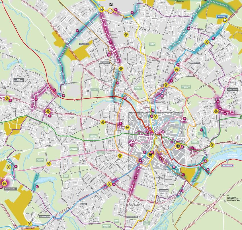
Contents
                                                                                                                                                              Page number
1. Introduction……………………….………………………………………………………………………………..……………….……..…... 2

2. Why improve the cycling and walking network?.............................................................................................................................. 3

3. Why do we need a Local Cycling and Walking Infrastructure Plan?............................................................................................... 4

4. How does the cycling and walking infrastructure planning process work?...................................................................................... 5

5. How does the infrastructure plan support national and local goals?................................................................................................7

6. What are the active travel network design standards? ……………..……........................................................................................9

7. What area does the cycling and walking infrastructure plan cover?..............................................................................................11

8. Priority active travel network development schemes.....................................................................................................................14

9. Priority active travel network support schemes…………………………..……………….…..……………………………………..…... 37

10. How will the priority schemes be delivered?..................................................................................................................................45

11. How will the success of the schemes be measured?....................................................................................................................46

12. What happens next? …………………………………………………………………..………………………………………..……….....47

                                                                                       -1-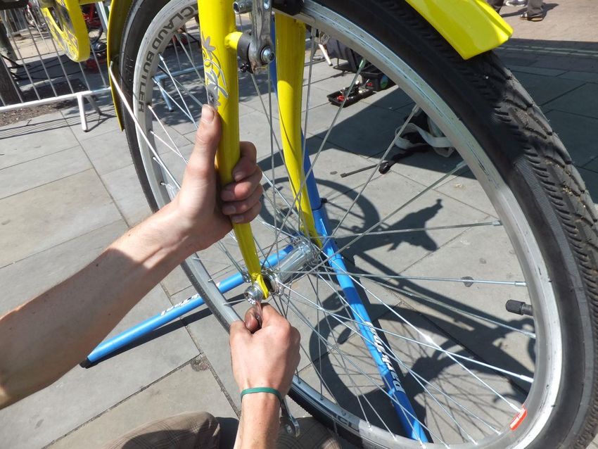
1. Introduction
  Norfolk County Council are working in partnership with Norwich City Council,
  Broadland District Council and South Norfolk Council to create a Local Cycling and
  Walking Infrastructure Plan for the Greater Norwich area.

  The objective of the plan is to identify and prioritise improvement schemes which
  can be made to the cycling and walking (active travel) network over the short,
  medium and long term.

  The purpose of this summary is to share information about the active travel network
  improvement schemes which have been identified during the planning processes
  and to enable residents and stakeholders to review and share their feedback.
  The summary also sets out the reasons for improving the active travel network for
  Greater Norwich and includes details on how the infrastructure plan has been
  developed, as well as how the new schemes will be designed and delivered.
  Norfolk County Council are now actively encouraging residents and stakeholders to
  review the active travel network schemes contained within this summary and to
  share their feedback via an on-line survey.
  By taking part in the survey you can help to ensure that the final priority schemes
  focus on the right areas of the network and deliver an active travel network which is
  accessible for everyone living in or visiting the region.
  The Greater Norwich active travel survey is open from 17th May to the 28th June.
  To take part in the online survey please visit www.norfolk.gov.uk/activetravel

      This summary provides information about active travel network improvement schemes for Greater Norwich

                                                                -2-
2. Why improve the cycling and walking network?
  Research has shown that cycling and walking are good for our physical and mental healthi and by making more journeys via
  active modes of transport, we can improve our quality of life, benefit the environment and enhance local productivity.

                                                                                                           Improved
                                                                                                           air quality

                                                                                                                                  Combating
                                                                                   Reducing
                                                                                                                                   climate
                                                                                  congestion
                                                                                                                                   change
                                                                                                          Local Cycle
                                                                                                           & Walking
                                                                                                          Infrstructure
                                                                                                              Plan

                                                                                                                          Improved
                                                                                           Addressing                     physical &
                                                                                           inequalities                    mental
                                                                                                                            health

              Figure 1: The medical benefits of cycling and walking              Figure 2: The benefits of increased levels of cycling and walking

  When investing in cycling and walking networks can also help tackle some of the most challenging issues we face as a society
  by improving air quality, combatting climate change, addressing inequalities in society and tackling congestion on our roads ii.

           Increased levels of cycling and walking has long term environmental, economic and health benefits

                                                                      -3-
3. Why do we need a Local Cycling and Walking Infrastructure Plan?
  In 2017, the Department for Transport (DfT) set out the national vision for cycling and walking
  and released the “Gear Change”iii policy paper, which provides local authorities with guidance on
  developing active travel networks.
  The policy contains four themes, which group together the key actions that need to be taken:
  Better streets for cycling and people – by providing safe, continuous, direct routes for cycling in
  towns and cities, physically separated from pedestrians and volume motor traffic, serving
  the places that people want to go.
  Cycling at the heart of decision-making – by ensuring that new housing and business
  developments include appropriate provision for cycling. Assessing transport schemes’ value for
  money with more focus given to the provision of cycling schemes. Railways and bus routes
  working better with cyclists, more cycle parking, plus promoting cycling for the carriage of freight
  in towns and cities.                                                                                     Figure 3: DfT Gear Change

  Empowering and encouraging Local Authorities – by enabling, encouraging and empowering local authorities to do more for
  cycling on their roads, including appropriate maintenance. In addition, £2 billion of new funding will be provided over the next
  five years to support local authorities with well-defined Local Cycling and Walking Infrastructure Plans.
  Enabling people to cycle and protecting them when they do – by ensuring that every adult and child who wants it can be trained
  how to ride a cycle safely. Working more closely with the NHS and incentivising GPs to prescribe cycling and building cycle
  facilities in towns with poor health. Combating bike theft and make legal changes to protect vulnerable road users, plus
  improvements to road safety for all road users. Establish a national electrically assisted bike support programme.
  A Local Cycling and Waling Infrastructure plan enables Norfolk County Council to identify and prioritise the active travel network
  improvements which enable more people to use the network and supports submissions for funding opportunities.

           The planning process enables priority active travel network development schemes to be identified

                                                                 -4-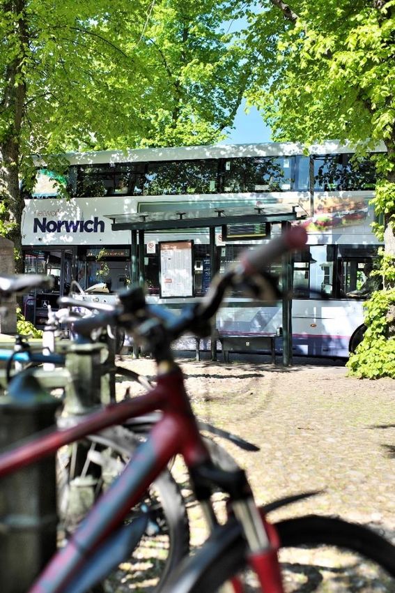
4. How does the cycling and walking infrastructure planning process work?
            The DfT ‘Gear Change’ policy document outlines six key planning stages which have been followed by Norfolk County Council.

    Stage         Objective                                                   How the objective was met for Greater Norwich
      1           Establish the geographical extent of the plan,
                                                                              The geographical area of the plan links with the Strategic Growth Area for
 Determining      and arrangements for governing and preparing
                                                                              Norwich. This was agreed by all four local council authorities. (see page 11).
   Scope          the plan.
                                                                     Census Data, Strava Metro Data (GPS) and traffic count data has been analysed
                  Identify existing patterns of walking and cycling, to identify existing patterns of walking and cycling and potential new journeys.
      2           and potential new journeys. Review existing        Network conditions and barriers to cycling and walking have been identified
  Gathering       conditions and identify barriers to cycling and    through Project Officer site visits and by reviewing existing plans and schemes.
 Information      walking. Review related transport and land use     A review of related transport and land use policies and programmes included a
                  policies and programmes.                           review of adopted Neighbourhood Plans and key strategic transport, environment
                                                                     and public health policy documents.
                                                                     Activities completed in order to create a cycle network plan included a review of
      3           Identify origin and destination points and cycle
                                                                     key destinations within Greater Norwich, cycle propensity modelling, and a review
Cycle Network     flows. Convert flows into a network of routes and
                                                                     of existing schemes identified from the Cycle City Ambition Grant Funding and the
  Planning        determine the type of improvements required.
                                                                     Transforming Cities funding bid.
        4
                  Identify key trip generators, core walking zones            Activities completed to create a walking network plan also included a review of
    Walking
                  and routes, audit existing provision and                    key destinations within Greater Norwich and a review of existing schemes
    Network
                  determine the type of improvements required.                identified in the Transforming Cities funding bid.
    Planning
        5         Public engagement and prioritise improvements
   Prioritising   to develop a phased programme for future                                                                 Current stage
 Improvements     investment.
        6
                  Integrate outputs into local planning and
Integration and                                                                                                              Next stage
                  transport policies, strategies, and delivery plans.
  Application
                                            Table 1: The six stages for developing a Local Cycling and Walking Infrastructure Plan

                                                                                    -5-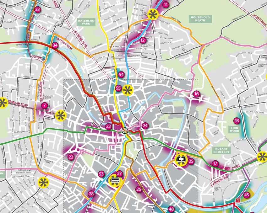
What are the outcomes of the planning process?

The three key outcomes of the planning process include:
•   a cycling and walking network plan which identifies preferred cycling and walking routes and core zones for further
    development.

•   a prioritised programme of cycling and walking infrastructure improvements which can be put forward for existing and future
    Active Travel funding opportunities.

•   a report setting out the underlying analysis which has been carried out on the network and provides an explanation of how
    the network improvements have been identified.

A comprehensive planning process enables local authorities to identify and prioritise active travel network schemes.

                                                             -6-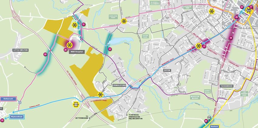
5. How does the infrastructure plan support national and local goals?
  The plan for Greater Norwich supports local and national transport, environmental and public health policies:

  Norwich & Norfolk Planning Policy             How the infrastructure plan supports planning policy
  Norwich 2040 City Vision                      The plan ties in with the Norwich 2040 City vision of ‘A Connected City’ by
  Norwich City Council                          supporting the ambition for a modern transport system that is at the forefront of
                                                digital connectivity with opportunities for all residents to link to each other.
  Norfolk access improvement plan (2019         By improving the cycling and walking network, the plan helps to provide an easy
  – 2029)                                       to use, safe, healthy and sustainable way to enjoy and connect with the Norfolk
  Norfolk County Council                        coast and countryside, which are key ambitions of the Norfolk Access
  Broads National Park & National Trails        Improvement Plan.
  The Norfolk Delivery Plan                     Increased cycling and walking as a mode of transport supports the response to
  Norfolk County Council                        the economic challenges of the pandemic and can help to maintain social
                                                distancing during the pandemic and avoid a car dominated recovery.

  Local and National Transport Policy           How the infrastructure plan supports transport policy
  Department for Transport “Gear                The infrastructure plan closely follows the guidance outlined in the Department for
  Change” and Cycle Infrastructure              Transports ‘Gear Change’ document and the Cycle Infrastructure Design
  Design Guide (LTN 1/20).                      guidance. The plan also shares the ambition of encouraging walking and cycling
                                                by making it safer and more practical to travel via these modes of transport.
  Norfolk Local Transport Plan 4 Strategy       The plan supports the Norfolk Local Transport Plan 4 and the Transforming Cities
  2021 – 2036 (emerging)                        funding bid by enhancing connectivity, increasing accessibility, improving
  Norfolk County Council                        transport safety and providing a well-managed and maintained transport network.

  Norfolk Cycling and Walking Strategy          The plan will help to achieve the ambitions of the Cycling and Walking Strategy by
  2017                                          encouraging an increase in the number of people cycling and walking for work,
  Norfolk County Council                        education and leisure, by providing safe and attractive opportunities to do so.

                                                               -7-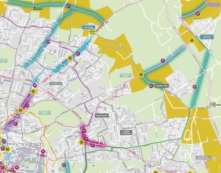
Environment & Air Quality Policy             How the infrastructure plan supports environmental policy
Norfolk County Council Environment     The ambition for Norfolk is to have net zero carbon emissions by 2030. In order to
Policy 2019                            achieve this, the use of sustainable modes of transport must be increased with a
                                       focus on walking and cycling.
25 Year Environment Plan               The Local Cycling and Walking Infrastructure Plan supports the Governments 25
HM Government                          Year Environment Plan by helping to reduce congestion and air pollution.
The Climate Change Act Revision (2019) The plan supports the ambition of net zero greenhouse gas emissions by 2050 by
HM Government                          delivering improvements to the cycling and walking network, which will help
                                       towards reducing congestion and carbon emissions from transport in the region.
Clean Air Strategy 2019                The plan supports the Clean Air Strategy by helping to reduce emissions from
HM Government                          transport.
The Paris Agreement 2015               The improvements to the cycling and walking network will help towards reducing
United Nations                         congestion and carbon emissions from transport in the region.

Public Health Policy                         How the infrastructure plan supports public health policy
Joint Health and Wellbeing Strategy          The Joint Health and Wellbeing Strategy aims to encourage healthy, independent
(2018-2022)                                  and resilient lives and to provide support to those most in need. Enabling more
Health and Wellbeing Board Norfolk &         people to cycle and walk as a form of transport supports this ambition.
Waveney
Public Health England: Working Together      The infrastructure plan delivers improvements to the active travel network which are
to Promote Active Travel 2016                aligned to the policy and practical actions recommended by Public Health England.

The plan for Greater Norwich also supports the Transforming Cities Programme which is a potential source of funding which could
help deliver the improvements to the active travel network in the short-term.

    The plan for Greater Norwich supports national and regional transport, health and environmental policies.

                                                            -8-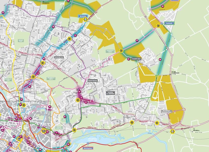
6. What are the active travel network design standards?
   The Department for Transport has created a set of ‘Cycle Infrastructure Design’iv guidelines which help local authorities to deliver
   improvements to the active travel network and represent the essential requirements for enabling more people to travel by cycle
   or on foot, based on best practice both internationally and across the UK.

   Design principles
   Government research and experience has found that
   when people are travelling by cycle they need cycle
   network routes which are coherent, direct, safe,                                                   Coherent
   comfortable and attractive. The application of design
   standards based on these principles helps to promote
   the use of active travel networks and to ensure that they
   can be accessed by everyone.

                                                                         Attractive                                                      Direct

                                                                                                 Accessability for
                                                                                                       all

                                                                                 Comfortable                                 Safe

Figure4: DfT Cycle Infrastructure Design Guidance                                 Figure 5: DfT Cycle Infrastructure Design Principles
                      Change

                                                                 -9-
Design principles in practice
The table below illustrates what the DfT design principles mean and how they will be applied to the active travel network.
Fig 5: Source: DfT Cycle Infrastructure Design document - core design
principles
DfT Cycle Infrastructure Design principles will be incorporated into all active travel network schemes.
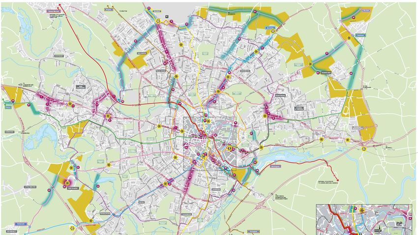
- 10 -7. What area does the cycling and walking infrastructure plan cover?
The core study area
The strategic growth area,
which surrounds Norwich
and extends as far as
Wymondham, has been
identified as the core study
area for the Greater Norwich
Local Cycling and Walking
Infrastructure Plan.
The strategic growth area
was originally defined by the
Greater Norwich Growth
Board, which is a local
government and enterprise
partnership with
responsibility for identifying
and funding infrastructure
improvement programmes
within the area.
Any potential cycling and
walking improvement
schemes which are outside
of the core study area will be
considered as part of future
planning activities.
Fig 6: Greater Norwich Strategic Growth area
- 11 -Norwich active travel network
Norwich has a network of active
travel routes which are locally
known as Pedalways.
The network is made up of six
arterial routes which cross the
city and two inner orbital routes.
Each of the routes are colour
coded and form a network
which link key residential areas
to places of education and
employment and enable access
to green spaces. The network is
also supported secondary
neighbourhood routes which
provide additional connectivity
across the network.
Although the current active
travel network routes are well
established, analysis of the
network has identified
opportunities which can
improve safety, connectivity and Fig 6: Local Cycling and Walking Infrastructure Planning area.
accessibility across the region
and support the wider delivery
of a sustainable transport
system for Greater Norwich.
Fig 7: Norwich active travel routes
- 12 -Walking zones
Norwich has two designated walking zones which give priority to pedestrians due to the high levels of walking traffic within these
areas. The first walking zone is located to the west of the city and connects the University of East Anglia campus, the Norwich
Research Park and the Norfolk & Norwich Hospital. The second walking zone is in the city centre and covers the historic area
within the boundaries of the old city walls. The walking zone improvement schemes highlighted within this summary incorporate
improvements which have been identified within the Norwich City Centre Public Spaces Plan.
Fig 8: UEA, Norwich Research Park and Norfolk & Norwich Hospital walking zone Fig 9: Norwich city centre walking zone
The plan focuses on prioritising cycling and walking routes and zones within the Greater Norwich strategic growth area.
- 13 -8. Priority active travel network development schemes
Fig 10: Greater Norwich active travel networks and scheme map.
- 14 -Horsford to City Centre route (Yellow)
Route description
This route provides active travel connectivity between the village of Horsford and Norwich City centre linking key destinations
along its route including the Nest Community Hub, Airport Park & Ride and the Airport Aviation Academy. The route also
connects dense residential areas with areas of employment and green spaces, such as Waterloo Park and Catton Park as well
as local schools along its route.
An extension of the shared use path on east side of Holt Road between Buck Courney
Crescent and the Broadland Northway will extend access to the village of Horsford 6
miles to the north of Norwich. Proposed schemes also improve off road connectivity
between the Airport Industrial Estate and the Airport Aviation Academy.
Priority improvement schemes
Reference Location Timescale Description
8 Norwich Airport Short term Provide a new sustainable transport
industrial estate link between the International Aviation
link Academy / Airport industrial estate and
Norwich International Airport. This link
will be for pedestrians, cyclists and
buses only and not general traffic.
31 Yellow Pedalway Medium / Off carriageway path on east side of
extension to Long Holt Road between Buck Courney
Horsford Crescent and the Broadland
Northway. Proposal includes a 3m
shared walking/cycle path.
32 Hurricane Way Medium / Widening to accommodate protected
Long cycle lanes
54 Edward Street Medium / Widening to create wider off
Long carriageway path or cycle contraflow
on carriageway with light segregation
- 15 - Fig 11: Yellow Pedalways scheme mapHarford Park & Ride to City Centre route (Yellow)
Route description
Connecting Harford Park and Ride and villages south of Norwich with key
employment areas along Hall Road. The route enables access to Norwich
City College via neighbourhood routes and the segregated off-road section of
the Lakenham Way before reaching the bus station and finishing in the city
centre.
The proposed scheme for this route would extend cycling and walking
provision to the Harford Park and Ride.
Priority improvement schemes
Reference Location Timescale Description
Feasibility to allow
cycle provision to the
Harford P&R cycle Medium / Park and Ride either
49
link Long via a shared use path
or segregated cycle
facility
Fig 12: Yellow Pedalway scheme map
- 16 -Sprowston to City Centre route (Blue)
Route description
From Sprowston Park and Ride, the route connects a
planned urban extension area of 10,000 new homes
with major retail outlets and schools, including
Sprowston Community Academy just off Wroxham
Road. The route also provides a key active travel
commuter route into the city centre via Magdalen
Street and links key retail areas.
New schemes will provide links with mobility hubs
along the route which enable people to access the
high frequency bus network.
Further changes will make the cycling and walking
route safer and more coherent by creating segregated
crossing points at junctions with major roads.
Bus time reliability issues caused by narrow streets
will be resolved through an assessment of changes in
traffic flow in the area.
Hindered pedestrian access on narrow streets will
also be addressed by schemes which widen footpaths
through kerb realignment.
Fig 13: Blue Pedalway scheme map
- 17 -Priority improvement schemes
Reference Location Timescale Description
11 Sprowston Road Short Provide an outbound (uphill) protected cycle lane alongside new sections
(Denmark Road - Term of inbound and outbound bus lanes. This will be facilitated by a
Outer Ring Road) combination of kerb realignment, narrower traffic lanes and parking
relocation to connect to the Broadland Growth Triangle (BGT).
12 Sprowston Road Short Consider that changes in traffic flow and on-street parking may be needed
(Magdalen Road – Term to significantly aid the flow of buses along this main public transport route
Denmark Road into the city centre from north Norwich and further afield. This is the most
significant cause of bus delay along this corridor. There are significant
improvements for pedestrians as cars will park entirely on the carriageway
and not half on the carriageway / half on the pavement as presently (due
to narrow carriageway widths and two-way traffic flows). Inbound cycling
will be safer and more attractive – outbound cycling will be directed onto
local quieter road.
37 Wroxham Road Med/ Long Extend existing bus lane on Wroxham Road and convert to 24hrs to
improve reliability of buses
Improve path on west side and allow cycling between Allen’s Avenue and
Blue Boar Lane with new crossings on Wroxham Road and Chartwell
Road
38 Denton Road crossing Med/ Long Create a new segregated cycle crossing on the ring road built to the
over Chartwell Road Governments Cycling Design Standards.
- 18 -Wymondham to City Centre route (Blue)
Fig 14: Blue Pedalway scheme map
- 19 -Route description
This route starts at the transport hub at Wymondham train station and links with the community hub before heading out onto
Hethersett and Thickthorn Park and Ride site. The route will provide connectivity for new large residential developments in the
area with key points of education including the University of East Anglia and Norwich City College before reaching the city
centre.
New schemes will deliver improved access at Wymondham train station as well as improved safety features for cyclists and
pedestrians.
Priority improvement schemes
Reference Location Timescale Description
19 Wymondham Rail Short Deliver step-free access to the Cambridge-bound platform, which is
Station platform Term currently not available for those with impaired mobility, suitcases,
access pushchairs, et
21 Newmarket Road Short Extend the high-quality Danish stepped cycle track to the Outer Ring
(Eaton Road – Term Road (ORR). Introduce a new signalised crossing to accommodate the
Christchurch Road) large numbers of pedestrians and cyclists travelling to the City of Norwich
School. Newmarket Road is a key bus corridor and the large flow of
buses will see journey time reductions and improved reliability through
traffic junctions at this location.
- 20 -Easton to City Centre Route (Green)
Route description Fig 15: Green Pedalway scheme map
The Easton route connects the village of Easton with Easton College and links in with the Park and Ride site at Costessey. The
route provides access to green spaces and connects with bus services and mobility hubs along the route.
The planned schemes will extend the current route and provide a safe crossing over the A47 and link in with new housing
development and Easton.
Priority improvement schemes
Reference Location Timescale Description
29 Path connection between Draper Way and Long Lane; widening Long
Green Pedalway Medium /
Lane; cycling and walking bridge over A47; off carriageway shared use
extension to Easton Long
path to Easton from Costessey Park & Ride
- 21 -Rackheath to City Centre route (Green)
Route description
The route links Broadland Business Park and areas
of high employment and housing to Norwich City
Centre via Thorpe St Andrew, the Heartsease Estate
and Norwich Train Station
Planned schemes improve access to Norwich train
station at Thorpe Road and extend access to the
business park and Rackheath.
Priority improvement schemes
Fig 16: Green Pedalway scheme map
Reference Location Timescale Description
13 St Williams Way Short Improvement of cycling link between Thunder Lane and Heartsease
Term Roundabout by incorporating light segregation into cycle lanes
17 Thorpe Road Short Located on the edge of the city centre, this scheme involves the
(Clarence Road – Term implementation of a contraflow lane to provide cyclists and bus
Carrow Road) passengers with a more direct and improved access to the rail station and
city centre along this key access route from the east of the city.
40 Broadland Way Med/ Long Traffic free shares use path parallel to railway between Broad Lane and
(Rackheath to Middle Road built to LTN120 standards
Dussindale)
- 22 -Wroxham to City Centre route (Pink)
Route description
The route links Rackheath into the city via
Thorpe End and provides connectivity for
major housing growth areas with Mousehold
Heath, the historic Cathedral area of the city
and city centre.
Development schemes will extend the current
route and provide improved cycling and
walking access to Rackheath and Wroxham.
Priority improvement schemes Fig 17: Pink Pedalway scheme map
Reference Location Timescale Description
39 Broadland Way Med/ Long Traffic free share use path parallel to railway between Wroxham and
(Wroxham to Salhouse Road built to the Governments Cycle Infrastructure Design
Rackheath) Standards
41 Salhouse Road Med/ Long Shared use cycling and walking provision on Salhouse road linking the
new development area to Rackheath
- 23 -Hethersett to City Centre route (Pink)
Route description
Starting at the large village of
Hethersett, the route connects
Norwich Research Park, the
Norwich & Norfolk University
Hospital and University of
East Anglia to the city centre.
New schemes will extend the
route at Hethersett which links
key areas of housing growth
with Wymondham.
A new mobility hub at the
Norfolk & Norwich University
Hospital will also help to
resolve congestion.
Priority improvement schemes
Fig 18: Pink Pedalway scheme map
Reference Location Timescale Description
50 Hethersett Lane Med/ Long Extension of cycling facilities from the new development at Hethersett
across the A47 and into Norwich Research Park. Feasibility required to
see if this can be segregated facilities or shared use
20 Norfolk & Norwich Short Provide a new bus interchange that resolves congestion and reduces the
University Hospital Term conflict with vulnerable users of the disabled car parking area. Also
mobility hub introduce a public cycle service to strengthen the mobility hub provision
and increase passenger capacity.
- 24 -Drayton to City Centre route (Brown)
Route description
The route connects the village of Drayton and areas of large housing growth at
Hellesdon with industrial and retail areas to the city centre via the Marriott’s
Way. The route also serves key areas of employment at the Airport Industrial
Estate and provides cycling and walking access to schools including Hellesdon
High School and Mile Cross Primary school.
Development schemes will help to overcome difficulties with crossing the
Boundary Road at Mile Cross and improve transport services at the Mile Cross
Road shopping area.
Fig 19: Brown Pedalway scheme map
Priority improvement schemes
Reference Location Timescale Description
10 Cycle and pedestrian Short Access into the city from Hellesdon for cyclists is difficult because there
crossing of Outer Ring Term are no crossings over the Boundary Road section of the outer ring road
Road (Mile Cross) for cyclists. The pedestrian crossing facility at either between Rye
Avenue / Vera Road or Marshall Road / Overbury Road will be upgraded
for use by cyclists. This will connect to a proposed Pedalway route to
Hellesdon via Reepham Road.
33 Mile Cross Road Med/ Long Co-locate and consolidate all shared transport services to create an
improved transport interchange at this busy, out of city centre shopping
arcade.
- 25 -Poringland to City Centre route (brown)
Route description
Connecting Trowse with the city centre via Bracondale and the bus station, the
route enables access to the designated growth areas at the old Colmans site
(Deal Ground).
The plan includes a feasibility to extend the route and create connectivity with the
large village of Poringland and beyond.
New schemes will also introduce improved safety for cyclists through the
introduction of protected cycle lanes at King Street and a traffic free route via Ber
Street.
Priority schemes to develop
Reference Location Timescale Description
44 Martineau Lane Med/ Long Feasibility required for
Improvement to walking and
cycling facilities on Martineau
lane linking to existing facility
on Bracondale
47 Bracondale Med/ Long Protected cycle lanes;
upgraded King Street /
Bracondale junction; closure
of Ber Street to traffic
between Finklegate and
Bracondale
Fig 20: Brown Pedalway scheme map
- 26 -Thorpe Marriott to City Centre via
Marriotts Way (red)
Route description
The route links the communities at
Drayton and Taverham through to New
Costessey with the employment area off
Barker Street and the Jane Austin
College. This leads into the City via the
Norwich University of the Arts, the Castle
and provides wider walking links to the
Riverside Walk.
Proposed schemes will create a more
coherent and safer cycling and walking
route by providing a segregated route on
the Marriotts Way and new crossing point
near Hellesdon Bridge
Priority improvement schemes
Fig 21: Red Pedalway scheme map
Reference Location Timescale Description
5 Marriott’s Way to Short Realign the existing Marriott’s Way walking and cycling route to the more
Hellesdon Road Term direct track bed route with a new sealed surface and a ramped access to
a new crossing close to Hellesdon Bridge.
- 27 -Whitlingham to City Centre route (red)
Fig 22: Red Pedalway scheme map
Fig 22: Red Pedalway scheme map
Route description
The route joins the city centre to the country park at Whitlingham via the new housing developments on King Street and the
Deal Ground site (formerly Colmans).
New schemes will enable the route to link villages from south Norfolk to the country park at Whitlingham via a proposed new
bridge over the River Wensum. These improvements improve connectivity and access to the river.
Priority improvement schemes
Reference Location Timescale Description
46 East Norwich Med/ Long Feasibility required for new link, including a new crossing facility
Regeneration Area over the Yare and Wensum connecting Whitlingham Lane to
(Carrow to Whitlingham) Geoffrey Watling Way
- 28 -Outer circuit route (purple)
Route description
This is the wider of the two orbital
routes which links all the
Pedalways together from the
Airport in the north to Lakenham in
the south of the city.
The route crosses all six of the
linear pedalways twice and passes
through key employment and
education including Norfolk and
Norwich University Hospital,
University of East Anglia and
Norwich airport.
The proposed schemes for this
route improve the safety of the
cycling and walking provision which
is already in place and help to
make the route more coherent.
Fig 23: Purple Pedalway scheme map
- 29 -Priority improvement schemes
Reference Location Timescale Description
14 Heartsease Lane Short Provision of new mandatory cycle lane facility with wands on both sides of
Term carriageway, improvement to the walking infrastructure with an upgrade of
the pedestrian crossing to a segregated crossing and footway widening
15 Heartsease Fiveways Short A redesign of the junction will provide significant improvements for cyclists
junction Term and pedestrians and enable bus operators to provide more efficient and
reliable services.
30 Hellesdon (Low Road, Med/ Long Feasibility required for improved provision for cycling and walking in
Hospital Lane and Hellesdon looking at the possibility of segregated cycle facilities, shared
Middletons Lane) use or traffic calming.
36 North Walsham Road Med/ Long 20mph and traffic calming inner section, protected cycle lanes outer
section; new section of North Walsham Road as part of Beeston Park
development
45 East Norwich Med/ Long Feasibility required for new walking and cycling route between Thorpe
Regeneration Area Road and Geoffrey Watling Way
(Martineau Lane to
Thorpe)
51 Colney Lane Med/ Long Feasibility for improvements to the existing facilities at Colney Lane either
via shared use path or segregated cycle facilities
- 30 -Inner circuit route (orange)
Route description
The inner orbital Pedalway links the Train
Station and Bus Station round to the north of the
city, through Mousehold Heath and serves key
residential areas.
The new scheme will deliver improved cycling
and walking conditions along the existing route
by widening the shared use path at Dolphin
Path.
Fig 24: Orange Pedalway scheme map
Priority improvement schemes
Reference Location Timescale Description
34 Dolphin Path Med/ Long Widening the shared use path at Dolphin Path which links between the
Marriott’s Way and Inner circular (Orange) Pedalway
- 31 -Norwich City Centre Core Walking Zone
Zone description
The Norwich City Centre Core
Walking Zone covers the
historic city centre and
includes key areas of
employment, education and
recreation. It also contains the
major transport hubs of the
train station and bus station.
This area has the highest
levels of walking in the
Norwich area and already has
pedestrianised zones.
New schemes for the Norwich
City Centre Walking zones are
constant with the Public Realm
Action plan which extends the
zone beyond historic wall to
incorporate the East Norwich
Regeneration Area. This area
includes the Carrow Works,
the Deal Ground and the
Utilities Site along the River
Wensum in the south east of
the city.
Fig 25: Proposed City Centre walking zone extension
- 32 -Norwich City Centre Walking Zone priority improvement schemes
Reference Location Timescale Description
23 Connecting the Short 1) Duke Street; completed riverside path at Dukes Palace Wharf to St
Norwich Lanes Term Georges Street will increase footfall across Duke Street, development of
(incorporating NUA site will increase footfall further.
Eastbound traffic 2) Fye Bridge Street; pedestrian crossing facility may be beneficial
reduction and between Mischief Tavern and Fishergate or Quayside.
Wensum Missing Link) 3) Whitefriars Bridge, crossing either side of river to Law Courts and
Jarrold St James site may benefit from pedestrian crossing facilities
4) Foundry Bridge; crossing from Hotel Nelson to Complete Angler
sections of path would benefit from pedestrian crossing facilities e.g. if
relocated from junction back towards the riverside path
5) Waterside (Bishop Bridge Road steps to Zaks Barrack Street)
reconstruction of mud track for all weather use, asphalt with drainage
24 Tombland Short Enhancements to walking and cycling links within Tombland, as well as
Term public realm and highway improvements
25 Norwich Rail Station Short Improve the Foundry Bridge junction next to the rail station with much
mobility hub Term more space for pedestrians and simpler crossing arrangements. Improve
access for cyclists and provide improved facilities for buses to serve the
station.
26 King Street Short Widen pavements and improve the cycle environment to create a
Term coherent and direct link for walking and cycling along National Cycle
Route 1 and improve the connection between cultural institutions,
substantial new residential development and the city centre.
27 Norwich Bus Station Short Improve pedestrian access to the Norwich Bus Station from Queens
mobility hub Term Road, encouraging an increased number of people to access the Norwich
Bus Station from the west.
28 St Stephen’s Road Short Improve the footway and pedestrian route along St Stephens Road
Term between St Stephen’s Street bus facilities and City.
48 Carrow Hill Med/ Long Feasibility into allowing contraflow cycling on Carrow Hill.
- 33 -53 St Stephens Med/ Long Feasibility required for at grade segregated crossing facilities at St
Roundabout Stephens Roundabout
55 St George’s Street Med/ Long New segregated cycle crossing on inner Ring Road to access Anglia
Square
22 Grapes Hill Short Review signalling arrangements to improve traffic flow, remove
Roundabout Term congestion to buses and general traffic through this busy junction and
accommodate cycling and walking crossings for users of the pink
Pedalway.
16 Kett’s Hill roundabout Short Improve safety for cyclists and introduce a bus lane on the city-bound
Term approach. This scheme strongly complements the Heartsease Fiveways
junction scheme as they
23 Connecting the Short 1) Duke Street; completed riverside path at Dukes Palace Wharf to St
Norwich Lanes Term Georges Street will increase footfall across Duke Street, development of
(incorporating NUA site will increase footfall further.
Eastbound traffic 2) Fye Bridge Street; pedestrian crossing facility may be beneficial
reduction and between Mischief Tavern and Fishergate or Quayside.
Wensum Missing Link) 3) Whitefriars Bridge, crossing either side of river to Law Courts and
Jarrold St James site may benefit from pedestrian crossing facilities
4) Foundry Bridge; crossing from Hotel Nelson to Complete Angler
sections of path would benefit from pedestrian crossing facilities e.g. if
relocated from junction back towards the riverside path
5) Waterside (Bishop Bridge Road steps to Zaks Barrack Street)
reconstruction of mud track for all weather use, asphalt with drainage
- 34 -University of East Anglia & Norwich Research Park Walking Zone
Fig 26: UEA / NRP walking zone scheme map
- 35 -Zone description
The UEA/ NRP Walking zone covers the campus area of the University of East Anglia (UEA), the Norwich Research Park (NRP)
and the Norfolk and Norwich University Hospital.
Development of the zone is intended to account for the future growth of the Norwich Research Park and covers some of the key
employment sites in Norwich.
The University Campus has high levels of walking and with the planned growth at this site we want to ensure walking remains a
key mode of transport.
A new mobility hub located and public cycle hire service at the Norfolk & Norwich University Hospital will also help to resolve
congestion. A new bridge across the River Yare will improve cycling and walking connectivity with the UEA.
UEA/NRP Walking Zone priority improvement schemes
Reference Location Timescale Description
20 Norfolk & Norwich Short Provide a new bus interchange close to the outpatient’s entrance that
University Hospital Term resolves congestion and reduces the conflict with vulnerable users of the
mobility hub disabled car parking area. Introduce bike share to strengthen the mobility
hub provision and increase passenger capacity.
52 Roundhouse Way – Med/ Long Provide new bus, cycle and pedestrian bridge across Yare Valley at the
UEA western end of Chancellors Drive as well as appropriate links on either
side of the bridge.
- 36 -9. Priority active travel network support schemes
Active travel network support schemes are services, facilities and physical infrastructure which help and encourage people to use
the active travel network. Examples include cycle parking facilities, cycle hire schemes, wayfinding signs, cycle training and
walking and cycling incentives. Norfolk County Council are developing the following schemes which help make the network more
accessible and enjoyable for all users.
Public Cycle Hire Schemes
Public cycle hire schemes provide members of the public with safe, easy
and affordable access to cycles which enable short trips to be made
without relying on motorised transport.
Norfolk County Council has recently partnered with Beryl Bikes and
launched a cycle hire scheme in Norwich in March 2020. Currently Beryl
Bikes have a fleet of 580 cycles available in Norwich and have recently
introduced e-scooters which can be found at one of the 80 parking bays
located around the city.
Since launch Beryl Bikes users in Norwich have covered the equivalent
of six and a half laps around the globe, according to figures from Beryl,
saving 43.92 tonnes of carbon dioxide emissionsv.
Norfolk County Council will continue to work with Beryl Bikes and seek
public feedback to help develop and extend the scheme within Greater
Beryl Bikes – Pedal bike, E-bike and E-scooter Norwich over the short to medium term.
Public cycle hire schemes help to provide easy and cost effective access to cycles
- 37 -Network Wayfinding Signs
Wayfinding signs help guide cyclists and pedestrians along a defined route
without the need to refer to a map or mobile device.
They are positioned along the journey at key decision points such as
junctions, and sometimes in-between for reassurance.
They also help maintain user safety, cut down on user conflict and keep
people informed and connected while they travel.
The signs also serve to create awareness of active travel routes and
encourage people to use them. Wayfinders can be found along the existing
Pedalways in Norwich.
Wayfinding signs, which comply with DfT design guidelines, will be
incorporated into any new network schemes which are put forward for
future funding bids.
Wayfinding sign in Norwich
Wayfinding signs help to connect active travel routes and encourage people to use the network.
- 38 -Secure Cycle Parking
Secure cycle parking facilities provide cyclists with the peace of mind that their cycle is safe and secure when not in use. The
design of the parking will vary depending on where it is located and how long the cycle is being stored.
Tubular cycle parking stands in Norwich Example of on-street parking hangers Cycle parking at Norwich Train Station
Cycle parking for short stays near busy locations such as shops, cafes and town attractions can take the form of simple tubular
stands, either on their own or in large quantities depending on demand.
On-street cycle parking hangers can provide secure storage in residential areas where storing a cycle at the home is not possible.
Cycle hubs can be found at locations that cater for large numbers of cyclists storing their cycle for long periods of time. Typical
locations for cycle hubs are railway stations, central bus stations, places of education and work. In the short to medium term
Norfolk County Council will work with partners to identify opportunities for new secure cycle parking sites with a focus on sites close to key
attractors (such as the train and bus station) and also longer term look to secure cycle parking in residential areas where there is
a lack of cycle parking facilities.
Access to secure cycle parking provides people with peace of mind when storing their cycle.
- 39 -Micromobility
‘Micromobility’ is a term used to describes the use of small lightweight electric vehicles to transport people and goods around
towns and cities.
Examples of these vehicles
include low speed electric
cycles and electric scooters as
well as cargo cycles which are
used by businesses to transport
goods within central locations.
Increasing the availability and
usage of these vehicles helps to
reduce traffic congestion, free
up parking space and improve
air quality which supports a
more healthy and sustainable
transport system.
In the short-term Norfolk County
Council will be keen to work
with strategic partners to pilot
the use of lightweight electric
vehicles to help transport
people and goods within the
Greater Norwich area.
Zedify cargo bike in Norwich
Adopting small lightweight electric vehicles in towns and cities can reduce congestion and improve air quality
- 40 -Mobility Hubs
A Mobility Hub is a location that connects multiple modes of public and non-
public transport and offers services which help make journeys safe, convenient
and as reliable as possible.
The features and services within a Mobility Hub will be influenced by its location
as well as the volume and type of traveller who will be using it.
Examples of additional transport services which may be available include cycle
and scooter hire, cycle parking, car charging and parking facilities, cycle repair
services, storage lockers, maps and transport information services as well as
shelter from the weather and refreshments.
Mobility Hubs help to raise the profile of shared mobility services which can
increase their use and commercial viability. In addition, they support low car use
lifestyles which could lead to lower demand for car parking spaces in central
locations with space being reallocated for housing or public area improvements.
In the short-term Norfolk County Council will be creating mobility hubs within
Greater Norwich and will be working with strategic partners to identify potential
new locations to grow the network over the medium term.
Mobility Hubs enable people to connect with multiple modes of transport
- 41 -Mobility-as-a-service (MaaS)
Mobility as a Service (MaaS) is a
term used to describe a digital
transport service platform that
enable users to access, pay for,
and get real-time information on a
range of public and private
transport options.
These platforms may also be
linked to the provision of new
transport services. They can save
people time and money and help
them to stay digitally connected
with live transport updates whilst
on the move.
Working with Government and
strategic partners Norfolk County
Council will seek opportunities to
invest in digital transport services
for Norfolk to enable easy and
efficient connectivity through the
region.
MaaS is a digital planning and information service connecting people with multiple transport modes
- 42 -Cycling and Walking Incentives
Cycling and walking incentives are designed to encourage people to use and enjoy the cycling and walking network.
Examples of incentives can include:
• cycle training and maintenance
programmes for schools and communities
• support for workplaces with cycle parking
• network maps,
• cycle loan schemes,
• plus, competitions to win cycling and
walking equipment.
The variety of incentives offered by local
authorities can change over time depending on
the needs of the local community and the level
of funding available.
Norfolk County Council currently offer a
programme of walking and cycling incentives
through the “Pushing Ahead” project (Pushing
Ahead | Your journey, your way
(pushingaheadnorfolk.co.uk).
Norfolk County Council will continue to develop
programmes like this over the short and
medium term to help communities and
businesses within Norwich to use the cycling
and walking network.
Incentives encourage people to use
- 43and
- enjoy the active travel networkSupporting network infrastructure scheme list
Scheme Timescale Description
Public Cycle Hire Short-term Norfolk County Council will continue to work with Beryl Bikes and seek public
Schemes feedback to help develop and extend the scheme within Greater Norwich over
the short to medium term.
Short/ Medium- Investigate funding opportunities for cycle parking solutions within Greater
Secure Cycle Parking term Norwich region.
Short/ Medium- Following infrastructure improvements improved wayfinding to publicise the
Wayfinding (for Cycling term priority routes and the destinations they serve.
and Walking)
Short/ Medium- Investigate opportunities for public/ private partnerships for micromobility pilots
Micromobility term including (but not limited to) e scooters and e cargo bikes
Short/ Medium- Working with Government and strategic partners Norfolk County Council will
Mobility-as-a-service term seek opportunities to invest in digital transport services for Norfolk
(MaaS)
Short/ Medium- Development of a targeting behaviour change programme to encourage more
Cycling and Walking term people to walk and cycle for economic, social, health and environmental
Incentives benefits. This will be developed in alignment with key stakeholders, including
public health.
Supporting infrastructure schemes make journeys easier and encourage people to choose cycling and walking
- 44 -10.How will the priority cycling and walking schemes be delivered?
By preparing a Local Cycling and Walking Infrastructure Plan for Greater Norwich, and gaining feedback from residents and
stakeholders, Norfolk County Council is able to identify which cycling and walking network improvements schemes to deliver
over the short, medium and long term.
This means that any short term priority schemes could be put forward for development and delivery through existing sources of
funding.
Potiential funding sources include;
• the Governments Transforming Cities fund which aims to improve productivity by investing in public and sustainable
transport infrastructure in English cities.
• and the Active Travel Fund which was announced by the Government in May 2020 to support short and long term cycling
and walking projects.
Any schemes which require Norfolk County Council to make a new funding application will be assesed by a new Government
inspectorate called Active Travel England. The role of the inspectorate is to assess all new applications and will decline any
applications which are not supported by a Local Cycling and Walking Infrastructure Plan.
The plan enables priority infrastructure improvements to be delivered as soon as funding becomes available
- 45 -11.How will the success of the schemes be measured?
In 2017 the Government published an investment strategy paper for cycling and walking networks, which includes four indicators
for measuring active travel network performance:
a. Cycling activity
Norfolk County Council will monitor the number of people cycling in the Greater Norwich region in order to measure any changes.
In recent years Norwich has seen a 40% increase in the number of people cycling as a mode of transportvi.
b. Walking activity
Norfolk County Council will monitor and measure actual walking activity and compare data against recent trends. Norwich has
also seen an 18% increase in the number of people walking as a mode of transport over the past 10 years.
c. Cycle safety
Key indicators of cycle safety will be monitored including, safety data counts and safety survey responses which provide a measure
of actual incidents and the public perception of cycling safety.
d. Active travel for education
Norfolk County Council will measure changes in the adoption of cycling and walking as a mode of transport for all pupils traveling
to a place of education, including primary and secondary schools as well as places for higher education.
In addition to these measures Norfolk County Council will monitor the levels of access to the active travel network, levels of single
occupancy car use, improvements in road capacity and improvements in air quality.
The Local Cycling and Walking Infrastructure Plan for Greater Norwich will be reviewed on a regular basis and resident and
stakeholders will have the opportunity to provide feedback on current schemes and contribute new scheme ideas.
Increases in active travel network access and use are key measures of success.
- 46 -12.What happens next?
Norfolk County Council now wish to obtain feedback from
residents and stakeholders on the proposed improvements
schemes outlined in this summary.
This will enable the priority schemes to be identified which
will support a phased programme for future investment in
the Greater Norwich cycling and walking network.
If you or your organisation require any further information
about the Local Cycling and Walking Infrastructure Plan for
Greater Norwich or wish to share your feedback on the
proposed schemes, please visit
www.norfolk.gov.uk/activetravel
To share your views on the Local Cycling and Walking Infrastructure Plan visit
www.norfolk.gov.uk/activetravel
- 47 -References
i Physical activity: applying All Our Health - GOV.UK (www.gov.uk)
ii Department for Transport: Gear Change, A bold vision for cycling and walking
iii Department for Transport: Gear Change, A bold vision for cycling and walking
iv Cycle Infrastructure Design (publishing.service.gov.uk)
v Norwich Beryl Bike riders covered 270,000 km in 2020: Eastern Daily Press article 27th December 2020
vi Source Cycle City Ambition Programme: Baseline and Interim Report March 2017
- 48 -You can also read