Mitigating post-oil sustainability challenges in a topographically framed transit-oriented city - ISOCARP
←
→
Page content transcription
If your browser does not render page correctly, please read the page content below
Tufek-Memisevic;T. & Ruzdic, Z;                            Mitigating post-oil sustainability challenges in
                                                             a topographically framed transit-oriented city

        Mitigating post-oil sustainability challenges in a
         topographically framed transit-oriented city
                        Tijana TUFEK-MEMISEVIC, Ph.D. Eng. Arch., Candarc, LLC, USA
                  Zina RUZDIC, MSc. Arch., Research Fellow at MIT, Bosnia & Herzegovina

       Abstract
A distinct environmental setting of the naturally elongated city of Sarajevo, Bosnia and Herzegovina stimulated its
historical development in a constant transit-oriented manner despite its frequent and diverse regime shifts, planning
practices and periods of war destruction. Topographically conditioned natural processes along with anthropogenic
factors contributed to increasing challenges to urban sustainability. With Sarajevo in the top ranks, the country’s
alarming level of air pollution was rated number one in Europe in 2019 with an annual average of 40,9 µg/m3 of
PM2.5 (IQAir, 2020). The emergence of high-rise development without proper long-term planning strategies largely
contributes to smog retention as a recent study on ventilation corridors in the city has shown (EBRD, 2019). As in
many Southeast European cities over the last few decades, Sarajevo is dealing with an urban sprawl generated by
the development of informal settlements (Tsenkova, 2012). These represent the dominant developments on
surrounding hillsides around the city, accessible mainly by vehicle transportation, creating an aggravating factor on
infrastructure, air quality and future development. Current practice in mitigating these challenges are scarce and
often obstructed by adverse political agendas. The border of two uncooperative and structurally different governing
Entities stretches alongside the city and hinders a unified long term regulation plan. The main research approach of
this paper is based on grounded theory and case studies of cities with similar elevation variations. The paper
establishes two main challenges to a sustainable urban development for a valley-based city in air quality and
transportation. It elucidates sustainable urban planning opportunities in an oil-depleted future of Sarajevo while
dealing with the given circumstances of urban disengagement and infrastructural pressure of the peripheral hillside
developments and the urgent vertical growth restrictions in the valley, providing conceptual solutions for urban
integration of the largely informal settlements through cable propelled modes of transportation and heat source re-
evaluation.

       Keywords

Valley, air pollution, hillside developments, cable propelled transit

1. Introduction
         Urban areas around the world experience growing pressure on a sustainable and resilient existence
and development. In addition to rapid urbanization, climate change and natural disasters aggravated by
anthropogenic activity, the recent Covid-19 pandemic drew attention to the importance of health resilience
for the future of cities. One of the most significant environmental health hazards is air pollution with 90% of
global population breathing air that exceeds WHO annual PM.25 threshold of 10 μg/m3 (IQAir, 2020).
Communities exposed to long-term particle pollution are also at higher risk of severe or deadly infections
caused by the virus.

                                                                     56th ISOCARP World Planning Congress in Doha, Qatar
                                                                          International Society of City and Regional Planners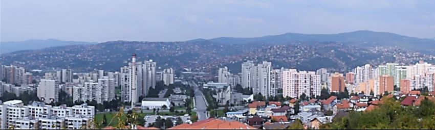
Tufek-Memisevic;T. & Ruzdic, Z;                            Mitigating post-oil sustainability challenges in
                                                             a topographically framed transit-oriented city

Development of long-term plans to mitigate post-oil sustainability challenges is a global as well as place-specific
effort. The aim of this paper is to highlight aggravating conditions in mitigating such challenges through air
quality control, transportation and planning policy specific to urban areas with certain topographic features,
as is the case of Sarajevo.
Sarajevo is the capital city of Bosnia and Herzegovina, located on the Balkan Peninsula in Southeast Europe. In
2019 the region was ranked highest in PM2.5 pollution in Europe and BIH number one most polluted country
with an annual average of 34,6 μg/m3 (IQAir, 2020). Although geographically being part of Europe, Bosnia and
Herzegovina is not part of the EU. Together with several neighboring countries it is neither a developed nor
developing country. It is classified by WESP as a country with transitioning economy. The way politics and
planning policy has been conducted since the dissolution of Yugoslavia and the war of 1992-1995, impacted
the prolongation of this status. As such, the country currently does not succumb to the strict environmental
policies of the EU which has significant implications on the environmental challenges that it is facing.
Sarajevo has a distinct topography which significantly influenced the city’s development throughout history.
It is situated in a narrow valley which conditioned urban spread onto the adjacent hillsides. Traffic in the city is
strongly oriented towards a main artery along the valley and Miljacka river basin. Essentially, Sarajevo is a
naturally elongated mostly transit-oriented city with a complex and diverse historic background. Frequent
shifts in regime and war destruction prevented a planned large-scale city development. One of the
consequences of the unstable socioeconomic conditions is the construction of illegal settlements on the slopes
and landslides. These settlements are predominantly residential. They are poorly connected to the main traffic
system, create pressure on the cities infrastructure system, services and use heating sources that contribute
significantly to air pollution.

The main research methodology of this paper is grounded theory based on data collection and analysis in
addition to case studies of urban areas with similar topographic features. The paper provides conceptual
solutions mitigating the effects of air pollution through a revision of heating sources, traffic interventions and
commuter options in an urban area that largely depends on fossil fuels. The solutions also aim to strengthen
the urban integration of hillsides with largely informal settlements and possible recreational areas. The
purpose of it is to elucidate sustainable urban planning opportunities in an oil-depleted future of the city by
adhering to the principles of transit-oriented planning consistent with Sarajevo’s historic development while
also dealing with the existing environmental circumstances, urgent vertical growth restrictions in the valley
and urban disengagement of the hillside developments.

2. Post-oil challenges to cities in valleys
2.1. Air quality
Environmental conditions of most cities around the world are inevitably influenced by less or more significant
elevation variations in their vicinity. This influence is particularly important for cities that are based in valleys
because they experience a type of Advectional temperature inversion called the Intermontane Valley inversion.
It usually happens during cold season when a layer of warm air traps the denser cold air descended from
adjacent mountains. However, when mixed with particles from burned fossil fuels the polluted air cannot
escape and disperse. This condition can last for days significantly increasing the health risk of inhabitants. What
can be influenced though, is the emission of pollutants. Sarajevo is one of these cities as well as Santiago, Chile
which ranks as one of the most polluted cities in Latin America. Chile’s cold season is opposite to Sarajevo’s
and lasts from May to August. To address the issue of air pollution the government of Chile launched a program
to replace old firewood heaters with more energy-efficient ones which resulted in a reduction of emissions.

                                                                     56th ISOCARP World Planning Congress in Doha, Qatar
                                                                          International Society of City and Regional Planners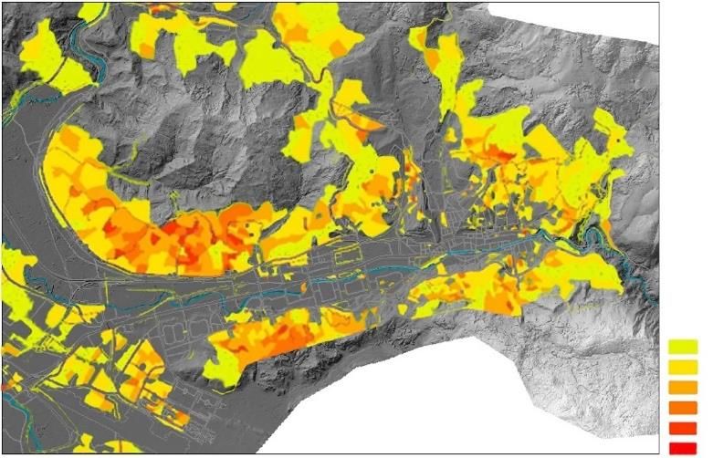
Tufek-Memisevic;T. & Ruzdic, Z;                           Mitigating post-oil sustainability challenges in
                                                            a topographically framed transit-oriented city

Australia and North America on the other hand are regions with lowest overall pollution levels in the world due
to successfully implemented emission controls across numerous industries. There are still cities that exceed
the WHO threshold, though. Salt Lake City in Utah experiences higher pollution intervals during winter season
due to valley temperature inversion. Since Central and South Asia is the most populated region in the world
with only 0.7% cities that meet the 10 μg/m3 WHO target, the region has been evaluated as too broad to be
included in this particular study.

Figure 1: Comparison of a one-year seasonal PM2.5 pollution between cities with and without elevation changes
Source: charts derived from interactive graph published by NY Times based on data from Berkley Earth

In the bar chart comparison of air pollution presented (Figure 1) cities situated in valleys are compared to cities
with modest elevation changes in 80km vicinity over the period of one year from November 2019-November
2020. Cities in valleys exhibit an increase in pollution pattern during cold season compared to cities in flatter
areas. Other cities in vicinity of mountains with different types of inversions and seasonal pollution as well as
parameters like size of urban area, population density etc. are purposefully neglected for the sake of exhibiting
the effects of Valley inversion on prolongation of higher-level seasonal pollution which is detrimental to human
health.

                                                                    56th ISOCARP World Planning Congress in Doha, Qatar
                                                                         International Society of City and Regional Planners
Tufek-Memisevic;T. & Ruzdic, Z;                           Mitigating post-oil sustainability challenges in
                                                            a topographically framed transit-oriented city

During the ongoing pandemic, as some cities had to go under lockdown for a period of time, and particularly
due to decline in motor vehicle transport, a worldwide decrease in air pollution has been noted. In order to
follow the WHO safety guidelines of physical distancing and social solidarity we stepped off the narrow
sidewalks and began to rethink the use and design of streets. Many cities closed their streets partially or fully
for vehicles and opened them up for pedestrian use and cycling. A creativity in resilience is exhibited through
alternative use of public spaces, like transformation of parking lots into parklets, open street dinning, outdoor
education, play and recreation, while supporting local businesses and helping the economy. This moment
presents an unprecedented opportunity to observe and test the possibility of permanently closing parts of
cities to individual motor traffic.

2.1. Trasnportation
Apart from air quality conditions another challenge to sustainable urban development for cities with significant
elevation variations is a lack of transportation options. If not regulated hillside developments are often
detached or isolated from the rest of the city and generally rely on vehicular mode of transportation producing
exhaust gases and contributing to air pollution. People living in informal detached settlements are subject to
social inequality and higher crime rates. The future of transportation in sustainable post-oil cities relies on
seamless connection of multimodal transit and use of environmentally friendly technology. A successful but
currently underused option for urban areas with elevation variations is both top and bottom supported cable
propelled transit.

Medellin, Colombia, situated in the Aburra Valley, set a precedent in using urban gondolas for commuter transit
in 2004. The cities hillsides were covered by low-income settlements with high crime rate where local
government had little control or presence. The effort of city officials was to socially integrate these areas,
improve housing, environment and public spaces by establishing innovative connection, increase mobility and
build new public facilities, infrastructure and parks. Medellin’s Metrocable system is continuously expanding.
It is considered one of the most successful examples of city transformation and became a model for many cities
that have built cable propelled transit or consider building one. In 2007 the city of Caracas, Venezuela located
in a narrow mountain valley started with the construction of a gondola system for public transport to connect
its poorer neighborhoods as well. The city’s Metrocable line is extraordinary because it is the first cable line
system that implemented a 90-degree turn. (Alshalalfah, B. et al, 2014). In 2006 Portland, OR, another valley
city, opened a different type of cable propelled transit called an aerial tram. Contrary to the gondola system
comprised of multiple smaller cabins, the aerial tram has only two opposite going cabins that are larger and
less frequent.

The aspiration to use cable propelled transit is not limited to cities with hillsides only. Paris is planning the
Televal gondola in 2021, and cities across the USA like Albany (NY), Austin (TX), Washington DC and Boston
(MA) are considering gondola systems too. Although they are not cities with challenging topography, the idea
is to provide a direct, novel and less expensive (than subways, monorails or trains) connection between city
areas or fly over gridlocked traffic with little public commuter options. A less successful example is the Emirates
Air Line in London which was built for the Summer Olympics 2012. The system experienced a similar fate as
many Olympic structures that have not been successfully integrated into the city infrastructure to serve
residents rather than tourists only.
Funiculars are a form of bottom supported cable propelled transit to be considered for more than just
attraction and recreation, but actual daily commute as well. Additionally, Medellin and Hong Kong have
systems of outdoor escalators in inclined areas. However, in Medellin they have not significantly influenced
the residents’ movement patterns (Reimerink, L. 2017).

                                                                    56th ISOCARP World Planning Congress in Doha, Qatar
                                                                         International Society of City and Regional Planners
Tufek-Memisevic;T. & Ruzdic, Z; Mitigating post-oil sustainability challenges in
a topographically framed transit-oriented city
3. Post-oil sustainability challenges in Sarajevo
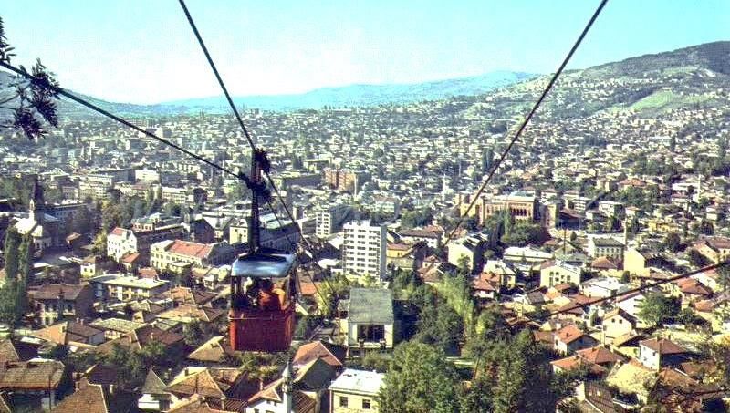
Figure 2: a) Sarajevo valley with mount Trebevic b) distinction between hillside and valley developments
Source: Author
Together with adjacent satellite settlements Sarajevo is part of an administrative zone called Canton Sarajevo.
Urban development in the valley is public, commercial and residential while the hillsides are predominantly
occupied by individual housing, many of which were built without regulation or permit, by semi-professional
workers and often under the risk of landslides. The urbanization process of these informal settlements began
during the Socialist period as a result of demographic changes, intensified in the post-war decades and
continues today on. After the war in 1992-1995 the urban area was administratively divided into two separately
regulated governing entities, with the larger part being in the Federation of BiH and smaller in Republic of
Srpska. The Inter Entity boundary line runs directly through part of the city, the settlement of Dobrinja.
Although a clear physical boundary doesn’t exist, there are opposing collective identities neglecting the
presence of the counterpart (Bassi, E. 2015). As a result, there is no unified planning policy or strategy on a
larger-urban scale that would encompass the whole urban area of Sarajevo for the foreseeable future. The
city’s ability to manage land use is affected by the existing informal settlements. In 2006 the governing bodies
issued regulations that would allow for the legalization of illegally constructed dwellings. The problem with
informal settlements is not unique to BiH. Neighboring countries like Croatia, Serbia, Montenegro and Albania
have such settlements as well and applied the legalization strategy in dealing with them (Tsenkova, 2012).
Sarajevo’s urban development is primarily conditioned by its topographic setting. The city lies at a 509m
elevation in a narrow valley strip among Dinaric mountains Trebevic (1627m), Jahorina (1916m), Bjelasnica
(2067m), Igman (1502m) and more. The valley is funnel-shaped and narrowest in the northeast, where most
of the urban development originated, and spreads southwest to a vast field called Sarajevsko Polje defined by
fertile areas and water-protection zones. The narrow shape conditioned a polycentric type of urban
development oriented towards the main transportation artery along the basin of river Mijacka (Figure 3). The
geomorphology of the area highly affects the climate in the city. Valley temperature inversions are common,
56th ISOCARP World Planning Congress in Doha, Qatar
International Society of City and Regional Planners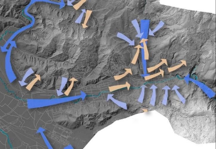
Tufek-Memisevic;T. & Ruzdic, Z;                          Mitigating post-oil sustainability challenges in
                                                           a topographically framed transit-oriented city

particularly during cold season when wind intensity and natural ventilation are reduced. Together with
anthropogenic activity a layer of smog and fog caps the city which often lasts for an extended period of days.
As the cooler night wind drain down the hills (Figure 4b), particularly down mountain Trebevic in the southeast
narrow part of the valley (Figure 3: sections 1,2,3) the warmer air rises above trapping pollutants underneath.
A heat island is formed in the Eastern part and polluted air is pushed further down the valley by morning winds.
High-rise residential buildings (Figure 2b) in the southwestern parts of the valley influenced the natural process
of self-purification of the valley.

Topography with section view and annotation (1-7 from East to West)

                                                                               1-1                                            4-4

                                                                                                                              5-5
                                                                               2-2

                                                                                                                              6-6

                                                                               3-3

                                                                                                                              7-7

Figure 3: Sections cuts through the valley on a 4 km width displaying different elevation changes and spread of the
valley Source: Map created based on Esri ArcGIS model and sections through extraction of topographic data

 Temperature map                                             Wind flow

Figure 4: Aerial maps displaying a)temperature differences and b) wind flow in the valley
Source: Maps created based on Esri ArcGIS model with overlaying data derived from CS Planning Institue’s
comprehensive map of “Natural sources and conditions”

                                                                   56th ISOCARP World Planning Congress in Doha, Qatar
                                                                        International Society of City and Regional Planners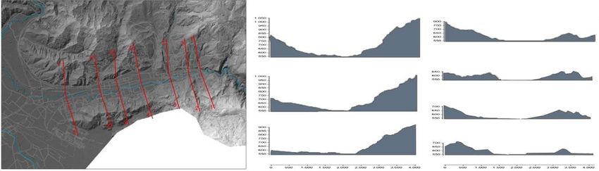
Tufek-Memisevic;T. & Ruzdic, Z;                            Mitigating post-oil sustainability challenges in
                                                             a topographically framed transit-oriented city

2.1. Air quality
As previously underlined Sarajevo ranks among the topmost polluted cities in Europe. The share of deaths
caused by air pollution in the BiH exceeds most countries in Europe. However, it is certainly not the only city in
BiH with the same problem. A steel company in Zenica and coal-fired power plants in Kakanj and Tuzla produce
the largest amount of air pollution in the country. If BiH became part of EU these heavy industry facilities would
have to obey to more strict environmental regulations.

Figure 5: a) Share of deaths from outdoor air pollution in BiH compared to average in Europe
b) and share of death compared to several other countries in Europe the period between 1990 to 2017 Source:
Our World in Data

The main causes of air pollution in Sarajevo (Figure 6b) are heating sources from residential, public sector,
industry and traffic (Ceteor, 2013). There are three main systems of heating in the city. The District Heating
System (DHS) which primarily runs on natural gas, central boiler rooms and individual stoves that use different
heat sources. In the overall energy consumption in Sarajevo Canton gas takes up 53.2%, followed by firewood
with 17.5%, coal lignite, brown coal 7.7%, electricity 6.0%, fuel oil 1.6% and pellets/briquettes 0.95%. (UNDP,
2019).

                                  Gas 53.2%
                                  Firewood 17.5%
                                  Coal lignite 13.05%
                                  Brown coal 7.7%,
                                  Electricity 6.0%
                                  Fuel oil 1.6%
                                  Pellets/briquettes 0.95%

Figure 6: a) chart with heating source distribution in Canton Sarajevo based on data from UNDP Feasibility Study 2019
        b) PM10 particle distribution across sectors based on Action plan by CETEOR 2013

                                                                    56th ISOCARP World Planning Congress in Doha, Qatar
                                                                         International Society of City and Regional Planners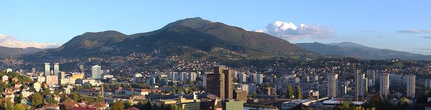
Tufek-Memisevic;T. & Ruzdic, Z;                           Mitigating post-oil sustainability challenges in
                                                            a topographically framed transit-oriented city

Individual housing that is usually located in the hillsides, use the more enviromentally damaging heating
sources because most of them are informal settlements and energy poverty is a significant factor. Another
reason is that gas piplines are not easily distributed to these areas.

The UNDP and the Italian Ministry of Environment, Land and Sea Protection in BiH conducted a feasibility study
introducing several scenarios for the expansion and improvement of the DHS. One option was to expand the
current system with natural gas as is. Another one was to expand the current system but transition to biomass
in three adjacent satellite settlements, and the third option was to build a pipeline and bring hot water from
the power plant in Kakanj. The study concluded that within current circumstances the option that would reduce
most emission would be the second option - through partial use of biomass. The possibility of building a
geothermal power plant in the southwest Municipality of Ilidza was also mentioned, as well as solar power
potenital. Ilidza is one of the oldest inhabited settlements in the region, dating back to Neolithic, and well
known for its thermal waters. Its geothermal energy is currently used for heating a few hotel facilites. The latest
efforts in borehole drilling to evaluate geothermal water temperature for potential larger distribution was done
in 2004, but not conducted entirely to the necessary depth. Together with solar power, the option of
geothermal energy has been mentioned in the study but it has not been pursued further due to a lack of
available data (UNDP, 2019).
 Individual heating sources                                   Transportation heat map

Figure7: a) Map displaying highest concentration of individual stoves b) Map displaying traffic pressure
distribution Source: a) created based on Esri ArcGIS model with overlaying data derived from CS Planning Institue’s
comprehensive map of “Natural sources and conditions” b) STRAVA heat map

Bosnia and Herzegovina is one of the most forest rich countries in Europe. In 2016 USAID BiH published a report
on the status and potential of biomass. Currently, there exist several small-scale biomass energy plants in the
country. Wood biomass is the dominant untapped source with 56% of technical potential, followed by crop
residue 35% and livestock residue 9% (USAID BiH, 2016). Although an environmentally more acceptable
replacement for fossil fuels, burning wood smoke emits harmful particulate matter, especially when used in
older stoves. With Sarajevo’s topographically conditioned air circulation and lack thereof, this byproduct of
combustion is a potential additional source of air pollution. There is still, however, potential of crop and
livestock residue or wastewater treatment as a possible sources of biomass.

                                                                    56th ISOCARP World Planning Congress in Doha, Qatar
                                                                         International Society of City and Regional Planners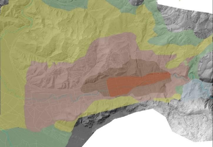
Tufek-Memisevic;T. & Ruzdic, Z;                          Mitigating post-oil sustainability challenges in
                                                           a topographically framed transit-oriented city

Apart from traffic and heating, planning policy plays a significant role in air quality of Sarajevo. A study using
Computational Fluid Dynamics in 2019 conducted air flow and particle simulation through parts of the city. The
study suggests further construction of high-rise buildings needs to be carefully evaluated and strategically
planned away from the recognized ventilation corridors in order to reduce pollution retention. (EBRD, 2019).

3.2. Transportation
The transportation system in Sarajevo follows the funnel shape of the valley with a predominant central artery
that carries a tramway line and a parallel longitudinal street with a trolleybus line. As the funnel narrows the
traffic congestion increases. However, the advantage of the orography and the current transit system is that
most valley-based points are in a walking distance from transit, making Sarajevo a transit-oriented city. The
public transit system, however, needs improvement and a distribution of additional railway lines, providing
safer, well maintained transit vehicles with reduced waiting time. Motor vehicles on the streets often do not
adhere to EU emission standards. The hillside areas in general are quite detached or connected with outdated
public bus lines that present safety hazards especially during wintertime. In 2018 Sarajevo’s old cable car line
was reconstructed and opened to public. The line connects the city to mount Trebevic, so residents and tourists
have a quick access to elevated area with fresh air and recreation.

As part of a PhD research on the linearity of Sarajevo’s urban development, the importance of expansion of
the transit network has been recognized. Moreover, a connection to the hillside developments through
funiculars, inclined elevators and vertical park design has been suggested. Sarajevo already has a settlement
with an operating inclined elevator. The settlement was constructed in the 1980s in one of the steepest slopes
in the city. Another proposed intervention is to limit traffic in the narrow part of the city, from Vijecnica to
Skenderija, and establishing an Origin City Center Loop. Except for the residents with permit, motor vehicles
would be allowed only in certain periods. Instead public transportation modes in the area would be multiplied
and more frequent. (Tufek-Memisevic, T., 2018).

Figure8: a) inclined elevator in Ciglane, Sarajevo       b) Sarajevo cable car

5. Conclusion
Cities surrounded by significant elevation changes deal with different types of temperature inversions.
Combined with anthropogenic factors it affects air quality and causes pollution retention. This problem is
particularly experienced in valley-based cities where such conditions can last for an extended period of time
and are detrimental to the wellbeing of inhabitants. In order to achieve a sustainable urban development
innovative modes of transit that are not dependent on burning fossil fuels need to be explored, especially in

                                                                   56th ISOCARP World Planning Congress in Doha, Qatar
                                                                        International Society of City and Regional Planners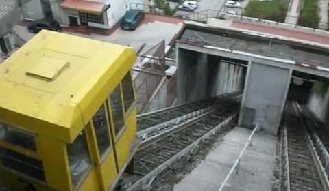
Tufek-Memisevic;T. & Ruzdic, Z;                             Mitigating post-oil sustainability challenges in
                                                              a topographically framed transit-oriented city

inclined areas. This research suggests that the post-oil future of valley-based cities like Sarajevo will significantly
rely on the use of top and bottom types of cable propelled transit for commuters, not only as an attraction.
CPT can be powered by electricity, gravity and even wastewater. Apart from low energy consumption these
transit options have numerous other advantages such as low space requirement on the ground, rather quick
installation and lower cost compared to other high-capacity public transport.
In a post-oil depleted future of cities that are topographically bound and influenced, in order to mitigate air
pollution it is particularly important to investigate new sources of energy for heating, as the cooler seasons
often tend to be more problematic in terms of air pollution.
The city of Sarajevo has existing potential to partly switch from fossil fueled energy sources to various types of
biomass. Geothermal plants are an additional opportunity that together with solar energy needs to be further
researched and pursued.

References

    •    Alshalalfah, B., Shalaby, A. and Dale, S. (2014). Experiences with Aerial Ropeway Transportation
         Systems in the Urban Environment. Journal of Urban Planning and Development, 140(1)
    •    Bassi, E. (2015). Divided Sarajevo: space management, urban landscape and spatial practices
         across the boundary. Europa Regional, 22.2014(3-4), 101-113
    •    Development Planning Institute of the Sarajevo Canton, (2016). Development Strategy of the
         Sarajevo Canton until 2020, Sarajevo
    •    EBRD & Ministry of Phisical Planning, Construction and Environment Protection (2019), Zeleni
         akcioni plan Kantona Sarajevo. Studija o urbanim ventilacionim koridorima i uticaju visokih
         zgrada, Sarajevo Available at:
         https://mpz.ks.gov.ba/sites/mpz.ks.gov.ba/files/studija_o_urbanim_ventilacionim_kori
         dorima_i_uticaju_visokih_zgrada.pdf (2019), [Accessed May 16th 2020].
    •    CETEOR (2013) Akcioni plan za smanjenje za smanjenje čestičnih tvari u zraku, Sarajevo [online]
         Available at:
         https://mpz.ks.gov.ba/sites/mpz.ks.gov.ba/files/Akcijski%20plan%20za%20smanjenje%20cesticn
         ih%20tvari%20-%20za%20WEB_0.pdf [Accessed May 16th 2020]
    •    REIC & Ministry of Physical Planning, Construction and Environment Protection
         https://mpz.ks.gov.ba/sites/mpz.ks.gov.ba/files/brosura-
         upravljanje_kvalitetom_zraka_u_ks.pdf, Brošura Upravljanje kvalitetom zraka u Kantonu
         Sarajevo [Accessed May 16th 2020]
    •    Reimerink, L. (2017). Planners and the Pride Factor: The Case of the Electric Escalator in
         Medellín. Bulletin of Latin American Research, 37(2), pp.191–205.
    •    Schwab, E., (2018) Spatial Justice and Informal Settlements. Integral Urban Projects in the
         Comunas of Medellin, Emerald Publishing Limited
    •    Tsenkova, S., (2012.) Urban planning and informal cities in southeast europe. Journal of
         Architectural and Planning Research, 29(4), 292-305.
    •    Tufek-Memisevic ,T., (2018) Contemporary linear city development. A case of spatial
         interventions in Sarajevo, BiH, Unpublished PhD thesis, Politechnika Krakowska, Kraków
    •    UNDP (2019), Feasibility study on expanding and improving the district heating system in
         Sarajevo Canton Available at

                                                                      56th ISOCARP World Planning Congress in Doha, Qatar
                                                                           International Society of City and Regional Planners
Tufek-Memisevic;T. & Ruzdic, Z; Mitigating post-oil sustainability challenges in
a topographically framed transit-oriented city
https://www.ba.undp.org/content/bosnia_and_herzegovina/en/home/library/environment_ene
rgy/SazetakStudijeDHKS.html [Accessed April 25 2019].
• USAID Bosnia and Herzegovina, (2016) Izvještaj o trenutnom stanju i potencijalu u BiH za izgradnju
kogeneracijskih postrojenja i elektrana na biomasu [pdf] Sarajevo: UNDP. Available at:
http://www.usaideia.ba/wp-content/uploads/2016/05/Izvjes%CC%8Ctaj-o-trenutnom-stanju-i-
potencijalu-u-BiH-za-izgradnju-kogeneracijskih-postrojenja-i-elektrana-na-biomasu-
2.pdf?fbclid=IwAR1oxaL0xjYvglrIIgO4Mzs8xonIqZAdxT4qgAAzU1p-HEn0luEH-W2p-pw
• www.iqair.com, (2020). 2019 World Air Quality Report. [online] IQAir. Available at:
https://www.iqair.com/world-most-polluted-cities/world-air-quality-report-2019-en.pdf
[Accessed Sept. 20th 2020].
56th ISOCARP World Planning Congress in Doha, Qatar
International Society of City and Regional PlannersYou can also read