Environmental Health Concerns Related to Volcanic Activity in Hawaii PHIP No. 43-01-0618
←
→
Page content transcription
If your browser does not render page correctly, please read the page content below
Public Health Information Paper
 Pub li c H ea lt h In f o rm at i on P ap e r

     Environmental Health Concerns Related to Volcanic
     Activity in Hawaii

     PHIP No. 43-01-0618

            Approved for public release; distribution unlimited

                          General Medical: 500A

                            June 2018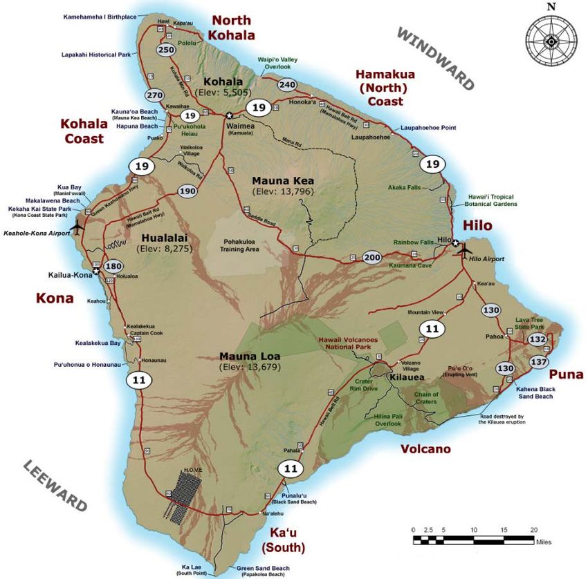
(UNCLASSIFIED)
Environmental Health Concerns Related to Volcanic Activity in Hawaii
June 2018
1 SUMMARY
Volcanic eruptions create solid, liquid, and gas releases that can present a threat to human
health and well-being. In May 2018, the Kilauea Volcano on the island of Hawaii entered an
active phase that is generating lava flows, gas emissions, and ash clouds that have persisted
for weeks and are likely to continue in the short term. There are many resources available to
Hawaiian residents to facilitate health and safety during these events. Personnel in proximity to
the eruptions, or downwind of the releases, should heed municipal authority precautions and
take protective measures to mitigate potential hazards.
2 BACKGROUND
2.1 Kilauea Volcano
Kilauea Volcano is one of the world’s most active volcanoes. Situated on the southeast side of
the island of Hawaii, it has been erupting continuously, with varying intensity, since 1983. The
current eruption cycle began on May 3, 2018 following a magnitude 5.0 earthquake that struck
the island. Kilauea is characterized by two major vents: the Halemaʻumaʻu crater, which sits in
the caldera at the summit of the volcano, and the Puʻu ʻŌʻō cone, which is 10 miles east of the
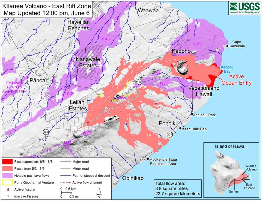
caldera (see Figure 1). Twelve miles east of Puʻu ʻŌʻō there is a 4-mile stretch of about two
dozen smaller fissures (or rifts) in an area known as the East Rift Zone (see Figure 2). These
rifts developed subsequent to the earthquake on May 3, 2018.
2.2 Volcanic Activity in 2018
During May 2018, there have been multiple eruptions from the Kilauea summit and the East Rift
Zone fissures. This volcanic activity has resulted in lava flows, volcanic smog (vog), sulfur
dioxide (SO2) gas emissions, ash clouds, and lava haze (laze) that have damaged land and
property in the Puna District of the island and led to enhanced surveillance and intervention by
state and Federal agencies to protect public safety and health. Scientists at the U. S.
Geological Survey (USGS) are uncertain about the duration of Kilauea’s current activity level but
assert that past experience suggests it will continue for weeks and possibly months. 1
2.3 Army Presence
Army assets on the island of Hawaii include the Pohakuloa Training Area (PTA), and the
Kilauea Military Camp (KMC) operated by the Army Family and Morale, Welfare, and
Recreation services. The PTA occupies 133,000 acres on a high plateau (above 5,000 feet) in
the center of the island. It is located 30 miles northwest of the Kilauea volcano. The KMC is
situated in the Hawaii Volcanoes National Park (2 miles northeast of the Halemaʻumaʻu crater)
and has been closed indefinitely due to concerns about the ongoing eruptions from Kilauea.
1Finucane, Martin, “Expert says Hawaii volcano could erupt for a long time, though it probably won’t explode.” Boston
Globe, May 22, 2018 [Internet] https://www.bostonglobe.com/metro/2018/05/22/expert-says-hawaii-volcano-could-
erupt-for-long-time-though-probably-won-explode/Xp74Tbad4zNJHyMEUjGXcM/story.html (accessed June 1, 2018).
(UNCLASSIFIED)
(UNCLASSIFIED)

 PHIP No. 43-01-0618, Environmental Health Concerns Related to Volcanic Activity in Hawaii

 2.4   Hawaiian Meteorology and Climatology
Public Health Information Paper
 The Hawaiian Islands are situated in the tropics where the length of day and temperature are
 relatively uniform throughout the year. There are only two discernible seasons: summer from May to
 October and winter between October and April. Airflow in this region is dominated by the trade winds,
 which blow from the northeast and east-northeast throughout the year. In summer months, trade
 winds prevail 80–95% of the time; in winter they prevail 50–80% of the time with lowest frequency in
 September and October. 2 A less frequent meteorological phenomenon is known as Kona winds that
 reverse direction and blow from the southwest and south-southwest. Kona winds result from low-
 pressure systems forming northwest of the islands and often accompany rain storms.

 3     ENVIRONMENTAL HAZARDS

 3.1   Lava

 Lava is the term for molten rock that breaks through the Earth’s surface. Lava fountains and spatter
 are issuing from the East Rift Zone fissures in and near the Leilani Estates and Lanipuna subdivisions
 in the Puna District. Hundreds of buildings and homes have been destroyed by the advancing lava
 flows, and municipal authorities have evacuated affected areas. On May 20, lava streams crossed
 State Highway 137 (on the southeast perimeter of the island) and entered the Pacific Ocean. The
 color of molten rock can provide a crude estimate of its temperature: Yellow indicates a temperature
 of about 1,832–2,192 degrees Fahrenheit (ºF). Orange indicates a slightly cooler temperature of
 about 1,472–1,832 ºF. Red is even cooler, about 1,112–1,472 ºF. The outer surface of erupting lava
 cools quickly when it is first exposed to air—hundreds of degrees per second. 3

 3.2   Volcanic Smog

 The term “vog” is a hybrid of the words “volcanic smog”. Vog is a hazy mixture of SO2 gas and
 aerosols (tiny particles or droplets), which are primarily sulfuric acid and sulfate compounds. Aerosols
 are created when SO2 and other volcanic gases combine in the atmosphere and interact chemically
 with oxygen, moisture, dust, and sunlight over minutes to days. The exact composition of vog
 depends on how much time the volcanic plume has had to react in the atmosphere. In areas such as
 the Kona coast, far from Kilauea Volcano's active vents, aerosols are the main component of vog.
 Closer to the volcano, vog contains both aerosols and unreacted SO2 gas. 4

 3.3   Sulfur Dioxide

 SO2 is present in gas bubbles dissolved in magma and is released from a volcano when magma is
 near the surface. If SO2 is detected at a nonerupting volcano, it could be a sign that it will erupt soon.
 Kilauea emits between 550 and 11,000 tons of SO2 each day during periods of continuous eruption.

 2 National Oceanic and Atmospheric Administration, National Climatic Data Center. Climate of Hawaii [Internet],
 https://www.ncdc.noaa.gov/climatenormals/clim60/states/Clim_HI_01.pdf (accessed May 25, 2018).
 3 USGS, Hawaiian Volcano Observatory. Frequently Asked Questions and Answers – Hawaiian Volcanoes and Hazards

 [Internet] https://volcanoes.usgs.gov/observatories/hvo/faqs.html (accessed May 25, 2018).
 4 USGS, Hawaiian Volcano Observatory. Frequently Asked Questions about Volcanic Smog [Internet]

 https://volcanoes.usgs.gov/observatories/hvo/faq_vog.html (accessed May 29, 2018).

                                                          2

                                                (UNCLASSIFIED)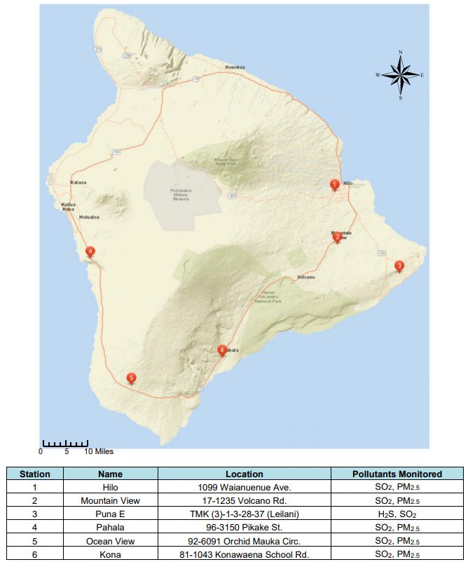
(UNCLASSIFIED)

 PHIP No. 43-01-0618, Environmental Health Concerns Related to Volcanic Activity in Hawaii

 Since 2008, Kilauea’s summit vent in Halemaʻumaʻu crater has been the dominant source of SO2
 emissions. In 2016, SO2 emissions from Kilauea were about 992,000 tons. 5 In contrast, 2016 SO2
Public Health Information Paper
 emissions from all U.S. anthropogenic sources were about 2.7 million tons. 6 SO2 is a colorless gas at
 ambient temperature and pressure. It can be detected by taste at concentrations of 0.35-1.05 parts
 per million (ppm) and has a pungent odor with an odor threshold of 0.67–4.75 ppm. 7

 3.4   Rock and Ash

 "Tephra" is the term for volcanic rock fragments exploded or carried into the air during an eruption.
 The largest fragments, blocks and bombs (> 2.5 inches diameter), can be expelled with great force
 but are typically deposited near the eruptive vent. Volcanic ash (< 0.1-inch diameter) is not the
 product of combustion but is formed during eruptions when gases dissolved in magma expand and
 escape violently into the air, or when water is heated by magma and abruptly flashes into steam. The
 force of escaping gas shatters solid rocks. Expanding gas also shreds magma, blasting it into the air,
 where it solidifies into fragments of volcanic glass. Volcanic ash is hard and does not dissolve in
 water. It is also extremely abrasive, mildly corrosive, and conducts electricity when wet. Ash is easily
 carried by the wind and may be deposited hundreds of miles downwind. On May 15, 2018, the
 National Weather Service (NWS) issued the first ever ashfall advisory for Hawaii.

 3.5   Laze

 The term “laze” is a hybrid of the words “lava haze”. Laze is formed when lava enters the ocean and
 triggers a series of chemical reactions resulting in a white cloud of steam, toxic gases, and tiny shards
 of volcanic glass. Water cools the lava, which forms a glass that shatters. Tiny pieces are picked up
 by the steam cloud, which contains hydrochloric (HCl) acid created by the interaction of lava and
 magnesium chloride salts present in the ocean water. Acid rain from a laze plume has a pH between
 1.5 and 3.5 and has the corrosive properties of dilute battery acid. Laze forms continuously as new
 lava is exposed to sea water.

 5 Elias, T., and Sutton, A.J., 2017. Volcanic air pollution hazards in Hawaii: U.S. Geological Survey Fact Sheet 2017–3017,
 4 p., https://doi.org/10.3133/fs20173017.
 6 USEPA, Air Emissions Inventories. Air Pollutant Emissions Trends Data [Internet] https://www.epa.gov/air-emissions-

 inventories/air-pollutant-emissions-trends-data (accessed May 29, 2018).
 7 National Research Council. 2010. Acute Exposure Guideline Levels for Selected Airborne Chemicals: Volume 8.

 Washington, DC: The National Academies Press. https://doi.org/10.17226/12770.

                                                              3

                                                    (UNCLASSIFIED)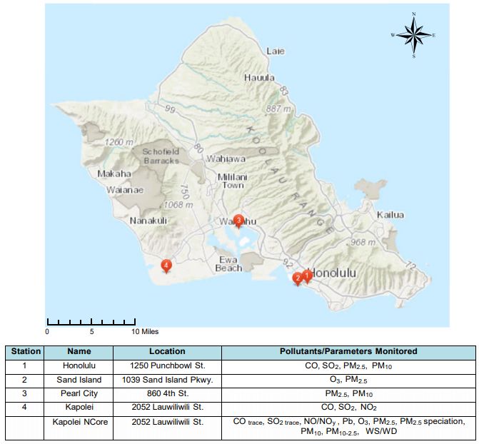
(UNCLASSIFIED)

 PHIP No. 43-01-0618, Environmental Health Concerns Related to Volcanic Activity in Hawaii

 4     HEALTH AND SAFETY ISSUES
Pu b l i cLava
 4.1       Health Information Paper

 The most immediate concern for lava is fire hazard for land and property, and burn hazard for human
 contact. Lava flows at temperatures upwards of 1,112 ºF. Although a lava surface can form a crust
 thick enough to walk on within a few minutes, the interior flow can take days to months to cool due to
 the insulating properties of the crust. As a direct result, lava deltas comprising newly formed land at
 an ocean entry are extremely unstable. Delta collapses occur without warning, sometimes sending
 tens of acres of the delta plunging into the sea. When this happens, it can trigger explosions that hurl
 rocks hundreds of yards, both inland and seaward, and send huge waves of scalding water onto the
 coastline. 8 Lava flow hazard zones on the island of Hawaii are shown in Figure 3.

 4.2   Volcanic Smog

 The primary constituents of vog are SO2 (from direct gas emissions) and particulate matter (from
 aerosol formations and ash releases). The particulate matter in vog is known as PM2.5 because the
 particles are less than or equal to 2.5 micrometers in diameter (less than 1/10th the width of a human
 hair). In general, most of the vog, SO2 and PM2.5 generated by Kilauea is dispersed over the
 southwest end of the island due to the flow of the trade winds. However, on the occasions when
 Kona winds prevail or the trade winds calm, pollutant levels created by volcanic releases can be
 elevated inland, and visibility can be impaired.

 The Hawaii State Department of Health (HDOH) measures SO2 and PM2.5 at a series of monitoring
 stations that ring the island (see Figure 4). These measurements are used to track compliance with
 state and Federal air quality standards and to report air quality hazards to the public. Between 2015
 and 2017, there were more than 300 days/year when outdoor SO2 levels exceeded the National
 Ambient Air Quality Standard (NAAQS) 1-hour standard for SO2 (0.075 ppm) on the island of Hawaii
 (see Table 1). SO2 concentrations above this level are considered unhealthy for some or all of the
 general public. Most of these excursions occurred at the Pahala and Ocean View stations (southwest
 end of the island) and Volcano National Park stations (near the Kilauea summit). This indicates that
 SO2 levels on Hawaii are chronically elevated, even during periods when Kilauea is not in a
 heightened eruption cycle. Limited data available for January-May 2018 indicates that recent SO2
 levels are consistent with previous years.

 Between 2015 and 2017, there were only 5 unique days (total) when outdoor PM2.5 levels exceeded
 the NAAQS 24-hour standard for PM2.5 (35 micrograms/cubic meter (µg/m3)) on the island of Hawaii
 (see Table 2). In contrast, there have already been 5 days between January-May 2018 when PM2.5
 levels have been unhealthy for some or all of the general public. Locations of HDOH air quality
 monitoring stations on the islands of Hawaii and Oahu, and the air pollutants that they measure, are
 shown in Figures 4 and 5.

 8USGS Hawaiian Volcano Observatory. Volcano Watch, 2016-09-15 [Internet]
 https://volcanoes.usgs.gov/observatories/hvo/hvo_volcano_watch.html?vwid=455 (accessed May 30, 2018).

                                                          4

                                                (UNCLASSIFIED)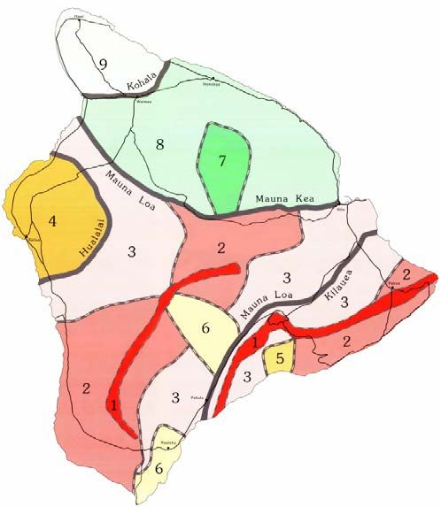
(UNCLASSIFIED)

 PHIP No. 43-01-0618, Environmental Health Concerns Related to Volcanic Activity in Hawaii

 Table 1. Days when the Outdoor SO2 Concentration was Higher than the 1-Hour NAAQS for SO2 on
 the Island of Hawaii, by Monitoring Station (days/year) 9,10
Public Health Information Paper
                       Site Name                            2018a 2017      2016       2015
         Volcano National Park - Visitor Center               ---  81         77        83
          Volcano National Park - Observatory                 ---  96        106        112
                           Hilo                               10   19         16        13
                          Kona                                 2    1          3         0
                         Puna E                               ---   0          0         0
                         Pahala                               68   230       243        200
                      Ocean View                              46   120       145        112
                    Mountain View                             19   15         28        36

      Unique Days When SO2 Concentration Was
                                                                      98             301           310        304
         Higher Than 1-Hour NAAQS for SO2
 a Selected   monitoring stations on island of Hawaii from January 1-May 31, 2018

 Table 2. Days when the Outdoor PM2.5 Concentration was Higher than the 24-Hour NAAQS for PM2.5
 on the Island of Hawaii, by Monitoring Station (days/year)9,11
                      Site Name                           2018a  2017        2016      2015
         Volcano National Park - Visitor Center             ---    0           1         0
          Volcano National Park - Observatory               ---    0           1         0
                          Hilo                               0     0           0         0
                          Kona                               4     0           0         0
                        Puna E                              ---    0           0         0
                        Pahala                               0     0           0         0
                     Ocean View                              2     0           4         0
                    Mountain View                            0     0           0         0

     Unique Days When PM2.5 Concentration Was
                                                                       5              0              5        0
        Higher Than 24-Hour NAAQS for PM2.5
 a Selected   monitoring stations on island of Hawaii from January 1-May 31, 2018

 9 HDOH, Clean Air Branch, Notification of Exceedance of a National Ambient Air Quality Standard [Internet]
 https://health.hawaii.gov/cab/files/2018/03/exceedances_2018_06_08_11.pdf, (accessed June 8, 2018).
 10 EPA, Outdoor Air Quality Data, Download Daily Data for SO , Hawaii, All Sites, 2015-2017 [Internet]
                                                              2
 https://www.epa.gov/outdoor-air-quality-data/download-daily-data, (accessed June 8, 2018).
 11 EPA, Outdoor Air Quality Data, Download Daily Data for PM , Hawaii, All Sites, 2015-2017 [Internet]
                                                              2.5
 https://www.epa.gov/outdoor-air-quality-data/download-daily-data, (accessed June 8, 2018).

                                                             5

                                                   (UNCLASSIFIED)
(UNCLASSIFIED)

 PHIP No. 43-01-0618, Environmental Health Concerns Related to Volcanic Activity in Hawaii

 There are additional air monitoring stations on the island of Hawaii operated by the U.S.
 Environmental Protection Agency (EPA), the National Park Service, and the USGS. In June 2018,
Public Health Information Paper
 EPA, HDOH and the Hawaii County Civil Defense Agency established a website that consolidates air
 monitoring data collected by these organizations and their partners. At the time of publication, the air
 data included SO2 and hydrogen sulfide (H2S) levels from approximately thirty locations on the
 island. 12

 Health concerns arising from exposure to vog constituents include—

       4.2.1 SO2 Inhalation

 Short-term exposures to SO2 can harm the human respiratory system and make breathing difficult.
 Children, the elderly, and those who suffer from asthma are particularly sensitive to effects of SO2.
 Even short-term exposures can cause narrowing of the airways (bronchoconstriction), inducing
 asthma symptoms. Negative health effects can increase as SO2 levels and/or breathing rates
 increase. At SO2 levels considered unhealthy for the general population, even nonasthmatics may
 experience breathing difficulties. The HDOH and EPA levels of health concern for varying
 concentrations and durations of SO2 exposure are shown in Table 3. Short-term SO2 exposure can
 result in increased emergency department visits and hospital admissions for respiratory illnesses,
 particularly in the aforementioned ‘sensitive groups’. Short-term health symptoms may include— 13

       •    Eye, nose, throat, and/or skin irritation
       •    Coughing and/or phlegm
       •    Chest tightness and/or shortness of breath
       •    Headache
       •    Increased susceptibility to respiratory ailments
       •    Fatigue and/or dizziness

       4.2.2 SO2 Contamination of Water Supplies

 Water from catchment systems in vog-prone areas can become acidic and leach harmful
 contaminants (such as lead, copper, and zinc) from roofing and plumbing materials, especially in older
 homes. Catchment water used for drinking or food preparation should be carefully monitored for ash
 infiltration. Based upon the magnitude or persistence of anticipated ashfall, it may be prudent to
 disconnect the water collection system until conditions improve or the catchment basin has been
 flushed. Alternatively, the pH of catchment water can be managed by adding baking soda to the tank
 or using an inline pH-adjusting filter.13

 12 EPA. Kilauea Eruption Air Monitoring [Internet] https://response.epa.gov/site/site_profile.aspx?site_id=12766 (accessed
 June 8, 2018).
 13 USGS. Frequently Asked Questions on Vog from Kīlauea Volcano, August 2016 [Internet] https://vog.ivhhn.org/FAQ.pdf

 (accessed May 31, 2018).

                                                              6

                                                    (UNCLASSIFIED)
(UNCLASSIFIED)
PHIP No. 43-01-0618, Environmental Health Concerns Related to Volcanic Activity in Hawaii
Table 3. Levels of Health Concern for Airborne SO2 Exposure
HDOH 15-minute SO2 EPA Air Quality Index 1-Hour
P u b lConcentration
i c H e a l t h I(ppm)
n f o r m a t i oSO
n PConcentration
aper Air Quality Status Color Code
2 (ppm)
0 – 0.10 0 - 0.035 Good Green
0.11 – 0.20 0.036 - 0.075 Moderate Yellow
0.21 – 1.00 0.076 – 0.185 Unhealthy for Sensitive Groups Orange
1.01 – 3.00 0.186 – 0.304 Unhealthy Red
3.01 – 5.00 0.305 – 0.604* Very Unhealthy Purple
> 5.01 0.605 – 1.004* Hazardous Maroon
* SO2 thresholds reflect a 24-hour averaging interval.
4.2.3 PM2.5 Inhalation
Solid particles or liquid droplets in the form of PM2.5 can be inhaled and cause serious health
problems. These particles can get deep into the lungs, and some may even get into the bloodstream.
People with pre-existing heart or lung disease, older adults, and children are most at risk from PM2.5.
Even healthy individuals can be at greater risk during times of heightened PM2.5 when exercising or
working strenuously since we breathe greater volumes of air, and more deeply, when physically
active. The EPA levels of health concern for varying concentrations of PM2.5 are shown in Table 4.
Both long- and short-term particle exposures have been linked to health concerns. High levels of
particle pollution have been shown to result in increased hospital admissions, emergency room visits
and even in premature death for some people with existing heart or lung disease. Low levels of PM2.5
are not considered as problematic for asthmatics as low levels of SO2 gas. Particle pollution can
cause temporary health symptoms such as—13
• Eyes, nose and/or throat irritation
• Coughing and/or phlegm
• Chest tightness and/or shortness of breath
Table 4. Levels of Health Concern for Airborne PM2.5 Exposure
EPA Air Quality Index 24-Hour PM2.5
Air Quality Status Color Code
Concentration (µg/m3)
0 – 12.0 Good Green
12.1 – 35.4 Moderate Yellow
35.5 – 55.4 Unhealthy for Sensitive Groups Orange
55.5 – 150.4 Unhealthy Red
150.5 – 250.4 Very Unhealthy Purple
250.5 – 500.4 Hazardous Maroon
7
(UNCLASSIFIED)(UNCLASSIFIED)
PHIP No. 43-01-0618, Environmental Health Concerns Related to Volcanic Activity in Hawaii
4.3 Ashfall
Public Health Information Paper
Respiratory health concerns resulting from ashfall are the same as those discussed regarding PM2.5 in
vog. However, ashfall has the potential to create additional physical hazards described below.
4.3.1 Roads
During an active ashfall, the resulting reduction in visibility can make driving conditions hazardous.
This danger is compounded by ash covering roads, which could cover road markings. Thin layers of
either wet or dry ash are very slippery, reducing traction. Thick deposits of ash may make roads
impassable.
4.3.2 Water Supplies
Ashfall can cause contamination of water or clogging and damage of water supply equipment. Small,
open-water supplies such as domestic water tanks with roof drainage (i.e., rainwater catchment) are
especially vulnerable to volcanic ashfall, and even small quantities of ash may cause problems for
potability. While the risk of toxicity is low, the pH may be reduced or chlorination inhibited. During
and after ashfalls, there is also likely to be extra water demand for clean-up, resulting in water
shortages.
4.3.3 Water and Wastewater Treatment
It is very difficult to exclude ash from sewers and stormwater collection networks. Systems with
combined storm water/sewer lines are most at risk. Ash will enter sewer lines where there is
inflow/infiltration by stormwater. Ash-laden sewage entering a treatment plant may cause blockage or
failure of mechanical prescreening equipment such as step screens or rotating screens. Ash that
penetrates further into the system will settle (due to gravity) and may reduce the capacity of biological
reactors, increase the volume of sludge, and increase the proportion of inorganic material in the
sludge which can alter digestion of decomposition characteristics.
4.4 Laze
The acidic nature of laze makes it a surface contact and inhalation hazard. Laze can cause skin and
eye irritation, as well as breathing difficulties. Concentrations of HCl in a laze plume can reach 7.1
ppm within about 10 yards of the contact between lava and seawater. This is higher than the 5-ppm
permissible exposure limit set by the Occupational Safety and Health Administration. However, within
100 yards of the source of the plume, the HCl concentration is likely to fall below 1 ppm. 14
14 Hunter, Dana, “The Lowdown on LAZE: Kilauea's Most Recent Hazard.” Scientific American, May 22, 2018 [Internet]
https://blogs.scientificamerican.com/rosetta-stones/the-lowdown-on-laze-kilaueas-most-recent-hazard/ (accessed June 1,
2018).
8
(UNCLASSIFIED)(UNCLASSIFIED)
PHIP No. 43-01-0618, Environmental Health Concerns Related to Volcanic Activity in Hawaii
5 RECOMMENDATIONS
Pu b l i cSituational
5.1 Health In f o r m a t i o (SA)
Awareness n Paper
Maintain SA regarding volcanic activity and resulting emergency conditions by subscribing to public
alert notifications. The County of Hawaii has established an Emergency Notification System to alert
subscribers to emergency situations and directed actions on the island of Hawaii. The USGS has a
Volcano Notification Service that provides notification email to subscribers about volcanic activity
happening at U.S.-monitored volcanoes. The alert can be customized for certain volcanoes, as well
as the type of notification.
5.2 Sulfur Dioxide
Maintain SA regarding outdoor SO2 levels, at-risk populations, and associated behavior
recommendations via the HDOH Short Term SO2 Advisory website. Two-day forecasts of SO2
concentration trajectories that can be used for planning purposes are available at the University of
Hawaii at Manoa Vog Model website. When SO2 levels are elevated, staying indoors, with doors and
windows closed, can help reduce exposures over a short time period (hours), depending on how well
the building is sealed from the outside environment. Air conditioning can provide comfort but will not
filter SO2 or PM2.5 from the air. Dust masks and other commercial masks sold to the public will not
protect against inhalation of SO2. Emergency response personnel or those expected to perform in
elevated SO2 environments should seek the guidance of qualified industrial hygiene specialists to
determine the proper personal protective equipment.
5.3 PM2.5 Exposure
Maintain SA regarding outdoor PM2.5 levels, at-risk populations, and associated behavior
recommendations via the EPA AirNow website. This tool shows both current PM2.5 conditions and 2-
day forecasts for all of the Hawaiian Islands. Emergency response personnel or those expected to
perform in elevated PM2.5 environments should seek the guidance of qualified industrial hygiene
specialists to determine the proper personal protective equipment.
5.4 Ashfall
Maintain SA regarding ashfall events via the NWS Hawaii Volcano Weather Products website.
Further, USGS requests that citizens report ashfall observations resulting from volcanic eruptions to
aid the NWS advisories. Presence of ashfall may be reported at the USGS Hawaiian Volcano
Observatory website.
5.4.1 Driving
Immediately after an ashfall, even a light one, driving conditions, visibility, and air quality can be
dramatically affected, especially by the resuspension of ash by traffic. Rainfall has a sudden but
temporary effect in improving air quality until the ash dries out again. Following an ashfall, refrain
from driving and stay indoors if possible.
9
(UNCLASSIFIED)(UNCLASSIFIED)
PHIP No. 43-01-0618, Environmental Health Concerns Related to Volcanic Activity in Hawaii
5.4.2 Indoor Environments
Public Health Information Paper
Keep all doors and windows closed whenever possible.
5.4.3 Respiratory Protection
Those undertaking clean-up operations should wear effective dust masks such as the N95 mask. The
Hawaii Emergency Management Agency has free dust masks available for County residents. If no
approved mask is available, a fabric mask improvised from cloth will filter out the larger ash particles
(but will not protect against toxic gases like SO2 or H2S). Dampening the fabric with water will
improve its effectiveness.
5.4.4 Eye Protection
In fine-ash environments, wear goggles. Wear corrective eyeglasses instead of contact lenses to
protect eyes from irritation.
5.5 Laze
Avoid areas where lava flow intrudes into ocean water. Masks used for dust protection are not
effective against acid vapors. Monitor wind direction as plume may be carried toward populated
areas. Monitor active lava flows as laze will be generated whenever new lava is exposed to sea
water.
Lisa M. Polyak/410-436-8158
Lawrence L. Webber/410-436-7685
Approved by: LTC Alick E. Smith
10
(UNCLASSIFIED)(UNCLASSIFIED)
PHIP No. 43-01-0618, Environmental Health Concerns Related to Volcanic Activity in Hawaii
Public Health Information Paper
Figure 1. Map of the Island of Hawaii. 15
15 Aloha Valley. Hawaii’s Largest Measured Earthquakes; to Date, May 23, 2015 [Internet] http://alohavalley.com/hawaiis-
largest-measured-earthquakes-to-date/ (accessed May 25, 2018).
11
(UNCLASSIFIED)(UNCLASSIFIED)
PHIP No. 43-01-0618, Environmental Health Concerns Related to Volcanic Activity in Hawaii
Public Health Information Paper
Figure 2. Map of East Rift Zone Fissures. 16
16 USGS, Volcano Hazards Program. Multimedia-Maps. [Internet]
https://volcanoes.usgs.gov/volcanoes/kilauea/multimedia_maps.html (accessed June 7, 2018).
12
(UNCLASSIFIED)(UNCLASSIFIED)
PHIP No. 43-01-0618, Environmental Health Concerns Related to Volcanic Activity in Hawaii
Public Health Information Paper
Figure 3. Lava Flow Hazard Map, Island of Hawaii. 17
17 Wright, T.L., Chun, J.Y.F. ,Exposo, Jean, Heliker, Christina, Hodge, Jon, Lockwood, J.P., and Vogt, S.M., 1992, Map
showing lava-flow hazard zones, Island of Hawaii: U.S. Geological Survey Miscellaneous Field Studies Map MF-2193, scale
1:250,000.
13
(UNCLASSIFIED)(UNCLASSIFIED)
PHIP No. 43-01-0618, Environmental Health Concerns Related to Volcanic Activity in Hawaii
Public Health Information Paper
Figure 4. HDOH Air Monitoring Stations on the Island of Hawaii. 18
18 HDOH. State of Hawaii, Annual Summary 2015, Air Quality Data. [Internet]
https://health.hawaii.gov/cab/files/2016/12/aqbook_2015.pdf (accessed May 30, 2018)
14
(UNCLASSIFIED)(UNCLASSIFIED)
PHIP No. 43-01-0618, Environmental Health Concerns Related to Volcanic Activity in Hawaii
Public Health Information Paper
4
Figure 5. HDOH Air Monitoring Stations on the Island of Oahu.18
15
(UNCLASSIFIED)You can also read