Bike Plan 2021 2025 - City of Subiaco
←
→
Page content transcription
If your browser does not render page correctly, please read the page content below

Bike Plan
  2021 – 2025

1.0 Introduction

2 | City of Subiaco Bike Plan 2021-2025
Contents
1   Introduction                                             4
    1.1 Framework                                            5
    1.2 A unique opportunity                                 6
    1.3 How this Bike Plan was developed                     6
    1.4 Changes since previous Bike Plan                     8
2   Recommendations                                          10
3   Neighbourhood plans                                      15
    3.1 Central Subiaco                                      15
    3.2 Eastern Subiaco                                      17
    3.3 Southern Subiaco                                     19
    3.4 Shenton Park                                         21
    3.5 Daglish / Jolimont                                   23
4   Bike crashes                                             25
5   Implementation                                           27
    Appendices                                               29

                                      City of Subiaco Bike Plan 2021-2025   |   3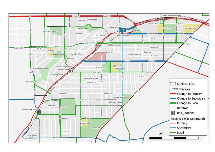
Part one Introduction

           Introduction
                               Approximately every five years, the City of Subiaco (the City) evaluates its cycle network to
                               determine if it continues to meet expectations of the cycling community and to identify where
                               the key opportunities are to make improvements in order to enable the City to set priorities for
                               cycling infrastructure investment.

                               This Bike Plan presents the priorities for the City over the coming five-year period 2021 to
                               2025. It does not lock in the annual works program budget, which will be undertaken by the
                               City each year as a separate process. Too often in a Bike Plan, individual projects are defined
                               in a manner that constrains the solution from being appropriately developed and investigated
                               through additional consultation with the community. The City has learnt from experience that
                               this approach limits the effectiveness of local bike plans, and flexibility is essential. Therefore,
                               this Bike Plan presents a guide to assist the City to implement solutions that will address
                               deficiencies in cycle infrastructure and attract more people to cycle safely within our City.
                               This approach has been agreed and supported by the Department of Transport (DoT)1 which
                               encourages Bike Plans to be prepared with a broad brush and a range of solutions presented for
                               Council’s consideration.

                               This Bike Plan has not been prepared purely for the confident rider. However, they represent an
                               important component of the cycling community. There is recognition that approximately two
                               thirds of the general population are interested in cycling but are concerned about the safety of
                               cycling on roads and interacting with traffic.2 These include children cycling to school, families
                               cycling to parks, and individuals cycling to work or the shops for the first time in a while. This
                               Bike Plan has been prepared with each of these people in mind.

           1
               The DoT are the State Government agency who oversee the implementation of the cycle network across Western Australia in conjunction
               with local government and other stakeholders.
           2
               R. Gellor, Four Types of Cyclists, Portland, USA (2009).

4 | City of Subiaco Bike Plan 2021-2025
1.1 Framework
                    1.1.1 State Government

                    Western Australian Bike Network Plan 2014-2031 (WABN)

                    One of the most important aspects of the Bike Plan is adhering to the principles and conditions set
                    out in the WABN Plan. The latest version is the 2017 update, current at the time of the development
                    of this Bike Plan. Alignment with the WABN is paramount to the City obtaining State Government
                    funding grants administered by the DoT and ensuring a consistent approach to cycling infrastructure
                    across the metropolitan area of Perth and Peel. Some of the key actions of the WABN Plan that are
                    most relevant to the City, are:

                       • Connecting Schools

                       • Perth Bicycle Network Grants Program

                       • Long Term Cycle Strategy for Perth

                       • Safe Active Streets.

                    Other key actions, such as Development of a Counting and Monitoring Strategy and Expansion
                    of the Principal Shared Path (PSP) Network, have relevance to the implementation of cycling
                    infrastructure in the City but provide less of a framework than the previously noted key actions.

                    Station Access Strategies

                    Public Transport Authority (PTA) Station Access Strategies are being prepared across all passenger
                    stations in the metropolitan area. Station Access Strategies sit within the PTA’s overall intent to
                    manage how people access each train station to facilitate an increased use to its passenger network.

                    The strategies prioritise active travel (walking and cycling) to access stations, and additional funding
                    opportunities are available to local governments to implement bicycle infrastructure projects that
                    demonstrate they meet this end. These strategies provide the implementation arm of a key action of
                    the WABN ‘Connecting Stations’ and set out infrastructure priorities to encourage more people to
                    cycle and walk to train stations safely. Train stations in the City each have a strategy, and these were
                    reviewed and have informed this Bike Plan.

                    1.1.2 City of Subiaco

                    Within the City of Subiaco, the Strategic Community Plan sets the future direction of the City in
                    accordance with community ambitions and priorities. Strategy 5.2.4 of the Strategic Community
                    Plan makes clear the City is to ‘invest in improved pedestrian and cycle networks’ to provide
                    our community with the ability to walk and cycle in and around the City.3 There are additional
                    City documents that provide a framework for this Bike Plan to be aligned to, including the
                    Subiaco Transport Access and Parking Strategy (2017). These are detailed in the Internal Reference
                    Document (IRD) which has been prepared supporting this Executive Summary Report. The City also
                    undertakes initiatives which are coordinated nationally, including the Super Tuesday Bicycle Counts
                    program and the Local Government Participation Survey. The Bike Plan sits within the framework of
                    these initiatives to inform and be informed by future data collation and evaluation.

3
    City of Subiaco Strategic Community Plan 2017 – 2027 (page 25).

                                                                                        City of Subiaco Bike Plan 2021-2025    |   5
Part one Introduction

                                1.2 A unique opportunity
                                Preparing this Bike Plan occurred during the unprecedented time of a global pandemic, where
                                travel patterns changed significantly and restrictions on movement and public gatherings were
                                put in place. The outbreak of COVID-19 affected businesses everywhere. Without overlooking
                                the hardships people experienced, there is a positive opportunity created by COVID-19, where the
                                general population also experienced what life looked like with less cars on the roads for a short
                                period of time. Anecdotal evidence indicated cycling numbers increased as government restrictions
                                allowed for exercise under social distancing, and it can be assumed people took the opportunity
                                to make some of their essential trips with less vehicles on the roads and perceived to be safer. This
                                appears to have been a global phenomenon,4 which provides an opportunity for the City to develop
                                a bicycle network in an environment where people are more open to the benefits cycling brings to a
                                community. There is also a greater resolve for communities to come together to solve the economic
                                challenges in which cycling can play a part.

                                1.3 How this Bike Plan was developed
                                The outcomes of this Bike Plan were derived through consultation with the people of the City,
                                particularly those who cycle, or whose children cycle to school. Input has also been provided by
                                people who live outside the City but cycle to or through the cycle network. These outcomes have
                                been tested against available information such as bicycle crash data, Super Tuesday bike count
                                information and recommendations pertaining to the cycle network in other existing literature. The
                                City undertook a saddle survey as part of developing this plan.

                                1.3.1 Neighbourhood Plan

                                The City has taken the approach to address issues on the cycling network with a localised
                                neighbourhood view, as well as a more holistic City-wide view. To achieve these two approaches,
                                the City was divided up into five ‘neighbourhood’ areas about 1-2km2 where land use and
                                transport patterns are more consistent (Figure 1.1). Where practical, busier roads or railways that
                                frame communities and influence transport movement borders were selected as neighbourhood
                                perimeters.

           4
               RAC, F. Bainger. (2020, May). Cycling Revival: COVID-19 and the Rise in Riding. Retrieved from https://rac.com.au/home-life/info/cycling-
               during-coronavirus (accessed 20 August 2020).

6 | City of Subiaco Bike Plan 2021-2025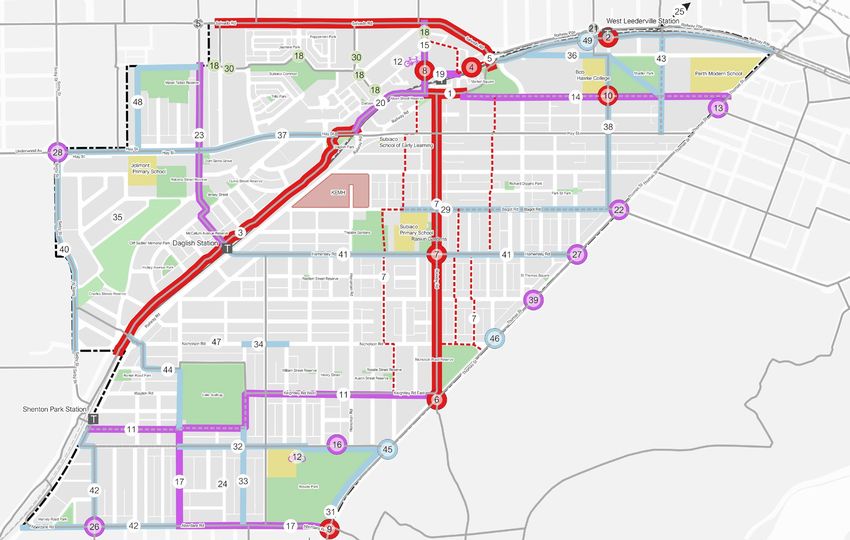
Figure 1.1: Neighbourhoods Selected in City of Subiaco

                                                 Central
                                                 Subiaco                                                Eastern

                         BISHOP STREET
                                                                                                        Subiaco

                                                                                       TOWNSHEND ROAD
                                                     HAY STREET

              Daglish/
              Jolimont                                                   BAGOT ROAD

                                                AY
                                             ILW
                                           RA

                                 EM
                                   AN
                                     TL
                                       E
                                                           Southern
                               FR
                                                            Subiaco

                                                        NICHOLSON ROAD

                      Shenton Park

1.3.2 Long Term Cycle Network

At the other end of the spectrum, the City has reviewed its cycle network within the broader
regional context consisting of surrounding local governments, and has sought to align with the
DoT’s Long Term Cycle Network (LTCN) that was being finalised as this Bike Plan was developed.
Adjacent local government areas and the Botanic Gardens and Parks Authority (Kings Park) have
been consulted to understand how people are riding across local government boundaries to
destinations either side. The City of Subiaco Council voted to support the LTCN on 21 April 2020.
The City’s endorsement of the principles of the network includes provision changes where necessary;
some which have been suggested in this Bike Plan.

Changes to LTCN

Changes to the agreed network suggested in this plan are indicated with ‘to be confirmed’ (TBC)
and the original agreed category provided as a footnote. Some changes were suggested based on
the outcomes of consultation, and observations of land uses and counts available.

Cycling Network Hierarchy

LTCN routes are categorised as Primary, Secondary, or Local in accordance with the Cycling Network
Hierarchy stipulated in the WABN Plan. These have been categorised by DoT based on the type of
activities that take place on the route. For the purpose of this Bike Plan, the complementary network
of Training Routes and Tourist Trails has not been considered.

                                                                                      City of Subiaco Bike Plan 2021-2025   |   7
Part one Introduction

                                Additional community routes

                                Routes that serve a cycle function for the City but do not fall on the designated LTCN have been
                                categorised as ‘Community Routes’ to ensure their distinction exists.

                                Further information on the LTCN including maps showing locations of suggested changes is
                                provided in Appendix A.

                                1.3.3 Community engagement

                                In conjunction with the City’s policy of community engagement for all planning activities, a
                                working group was established through an ‘expression of interest’ process at the early stages of
                                developing this plan. This group comprised of people of varying perspectives towards all that cycling
                                encompasses. For example, parents of students at our local primary schools as well as people with
                                experience riding on cycle networks in European cities were all represented who understood the
                                deficiencies and opportunities of their local areas. The neighbourhood approach allowed for people
                                to be represented across the entire City area to ensure adequate coverage in determining the
                                network priorities. Due to the outbreak of the pandemic, the process for consultation was altered,
                                and working group members were contacted by phone to document perspective towards where
                                improvements on the bicycle network should occur.

                                An online survey map on the City’s community engagement hub, Have Your Say Subiaco, allowed
                                for the wider community to locate a pin on their issue of concern in the City’s cycle network. More
                                than 200 pins were dropped at 90 separate locations which is substantial for a small sized local
                                government. The online survey map and working group input provided comprehensive information
                                on network priorities.

                                1.3.4 Cycling infrastructure built form

                                The designated LTCN route hierarchy is focused on the intended function of the route. The built
                                form of any individual route will be based on the physical characteristics of the location and has
                                been designed for the eight to 80 user group. This widely endorsed practice suggests that if
                                everything we do in our cities is great for an eight and an 80 year old, then it will be great for
                                everyone.5 The built form for bicycle routes, as set out in the WABN can be in the form of Principal
                                Shared Paths (PSP), high-quality shared paths, bi-directional protected cycle lanes, one-directional
                                protected cycle lanes and Safe Active Streets (Bicycle Boulevards).6

                                 The function of community routes will be designed to compliment the function of the LTCN routes,
                                and the eventual built form of these routes will reflect this. However, additional consultation will
                                need to take place prior to prescribing any specific treatments.

                                Protected cycle lanes are expected to be less common in the City with the competing car parking
                                demand on these routes. Implementation of Safe Active Streets comes at a significant expense and
                                might not be warranted across the expanse of the network. Therefore, quiet mixed traffic streets
                                with limited infrastructure interventions are being considered in this Bike Plan. On all routes,
                                the behaviour of motorists and bike riders will need to be monitored to ensure the built form
                                is appropriate.

           5
               Creating cities for all is a concept promoted by 8-80 Cities https://www.880cities.org/
           6
               Western Australian Bike Network Plan: 2017 Update, (page 43).

8 | City of Subiaco Bike Plan 2021-2025
1.4 Changes since previous Bike Plan
It is well understood how much the City has changed since the last bike plan was prepared six years
ago. However, there have also been some substantial changes at a state level which pertain to
cycling, including:

   • Cyclists above 12 years are now legally allowed to ride on footpaths.

   • Sealed shoulders (unprotected cycle lanes) are no longer acceptable practice and supported or
     funded by DOT. Infrastructure should have separation or be integrated with traffic.

   • Introduction of safe passing legislation requiring car drivers to overtake with a minimum of
     one metre passing distance of a cyclist (for local streets i.e. no more than 50 kilometre per
     hour speeds). This has implications for Local Area Traffic Management (LATM) treatments.

   • Safe Active Streets demonstration projects have been introduced in Perth.

   • There is a greater push for lower speed 30 to 40 kilometres per hour streets in Australia,
     especially in denser inner-city areas such as Subiaco.

   • LATM cycle guidelines and shared path guidelines are in preparation.

                                                                   City of Subiaco Bike Plan 2021-2025   |   9
Part two Recommendations

           Recommendations
                        Figure 2.1: City of Subiaco Project Priorities

                                                                                                                    LEGEND
                                                                                                                          Subiaco_LGA
                                                                                                                          Rail_Stations
                                                                                                                          Agreed LTCN
                                                                                                                    LTCN Suggested Changes
                                                                                                                        Addition
                        Haemodorum corymbosum, bloodroot
                                                                                                                          Removal
                                                                                                                    Future Network - Priority
                                                                                                                          High
                                                                                                                          Medium
                                                                                                                          Low
                                                                                                                          Alternative Route
                                                                                                                          Cambridge

                                                                                                                            Bike Parking Project

                                                                                                                            Minor Works

10 | City of Subiaco Bike Plan 2021-2025                                 10 | City of Subiaco Bike Plan 2021-2025
Part two Recommendations
The recommendations made to the City to improve its cycle network are outlined in Tables 2.1 to
2.3 and correspond to the map in Figure 2.1 on the previous page. Maps and tables of projects
within each of the neighbourhoods are provided in chapter three. It is the City’s intent to work with
the local communities in each neighbourhood (residents and business owners alike) to refine these
neighbourhood plans to tailor them to the community priorities.
The tables indicate where projects are on the LTCN; and projects that fall on routes which are not
on the LTCN, are suggested as community routes. Nicholson Road (project #47) is one exception,
and further consultation with the community is required. Given its traffic volumes and need for
separation from traffic, its status as a Community Route is questionable. It should be noted that
projects within a routes’ categorisation (Primary, Secondary, or Local) does not always indicate the
priority of the individual project, but rather the importance of the route in a regional, sub-regional or
local context. The priority has been suggested based on analysis of crash data and demand from the
community consultation.
The route that riders are cycling on has determined the category rather than the road being crossed.
2.1.1 High priority
A majority of the high priority projects have already commenced to a certain degree, mostly in terms
of design and discussion with relevant stakeholders.
Table 2.1: High priority projects
# Project LTCN
1. Improve the legibility and distinction of cycling and walking areas of the Primary
Perth to Fremantle Principal Shared Path between Station Street and
Brigid Lane.
2. Address the blind spot on the Perth to Fremantle Principal Shared Path Primary
at the intersection with Coghlan Road.
3. Make improvements including lighting and resurfacing to the Perth to Primary
Fremantle Principal Shared Path between Nash Street and Hay Street
(Daglish PSP).
4. Improve the eastern access to Subiaco Train Station from the Fremantle Secondary
PSP. Realign paths and kerb ramps. (TBC) 7
5. Implement the Salvado Road separated bike path from Bishop Street to Primary (TBC)8
Haydn Bunton Drive. The potential for an alternative route exists east
of Station Street. Liaison with Town of Cambridge required regarding
improving Jersey Street crossing.
6. Improve the crossing of Thomas Street at Rokeby Road / Saw Avenue. Secondary9
7. Make improvements to the conditions for cycling on Rokeby Road Secondary
including alternative routes that follow the same desire line of Kings Park
to Subiaco Train Station.
8. Improve the Station Street crossing between Coles Subiaco and Subi 10
Square Road.
9. Improve the crossing of Thomas Street at Aberdare Road. Secondary
10. Improve the crossing of Roberts Road at Coghlan Road. Local
7
Route currently not categorised but should form extension of secondary routes on Rokeby Road and Station Street, as well as connect to
PSP at Haydn Bunton Drive.
8
Route categorised as secondary but suggested in this Bike Plan as primary due to its regional importance connecting the Coast to Perth
CBD attracting large coverage across the western suburbs.
9
Rokeby Road categorised as secondary. Suggested Saw Avenue be added as secondary. This route crosses a primary route in Thomas Street.
10
Station Street crossing is a walking project of significance.
11 | City of Subiaco Bike Plan 2021-20252.1.2 Medium Priority
Table 2.2: Medium priority projects
# Project LTCN
11. Implement the Keightley Road / Evans Street safe active street. Local11
12. Improve and expand bike parking across the City including bike repair -
stations at specific locations (note: secure facilities are required at Rosalie
Primary School and sheltered parking is required at Coles Subiaco).
13. Improve the Thomas Street underpass at the former Princess Margaret Secondary
Hospital site for pedestrians and bike riders, as part of the redevelopment
of Subi East. Ensure it is well connected to Roberts Road, York Street and
Hamilton Street.
14. Implement separated cycling facilities on Roberts Road (facilities are also Secondary
to be considered on Hay Street). (TBC)12
15. Investigate improvements to cycling on Station Street. Separated on-road Secondary
infrastructure is expected north of Hood Street, and low speed shared
traffic more likely to be feasible south of Hood Street.
16. Install wheel stops to car park adjacent to Rosalie Park pathway. Local (TBC)
17. Improve Aberdare Road and Herbert Street connections to QEII Medical Aberdare:
Centre. Route to connect with Evans Street safe active street. Secondary
Herbert: Local
(TBC)13
18. Improve kerb ramp access at various locations in Subi Centro Secondary / Local
19. Investigate improvements to pedestrian and cycling environment on Secondary (TBC)
Subiaco Square Road. The focus is on reducing vehicle movements in the
section north of the train station.
20. Improve access to destinations by removing sections of hedging on the Primary
Perth to Fremantle PSP between Hay Street and Station Street.
21. Liaise with Town of Cambridge regarding improving the crossing of Local
Railway Parade on Northwood Street.
22. Improve the crossing of Thomas Street at Bagot Road with involvement Secondary
of the City of Perth. (TBC)14
23. Investigate and implement Jersey Street improvements (to align with Local
Daglish Station Access Strategy).
24. Develop behaviour change strategy specific for Shenton Park -
neighbourhood, to be used as a demonstration for the other
neighbourhoods.
25. Liaise with Town of Cambridge on improving connections north of Bob Local (TBC)15
Hawke College towards Leederville Station.
26. Investigate improvements to Aberdare Road / Smyth Road roundabout. Secondary
27. Improve the crossing of Thomas Street at Hamersley Road. Local
28. Liaise with Town of Cambridge on improving connections across Selby -
Street, particularly for students of Jolimont Primary School. Intersection
improvements of Selby Street / Hay Street to be modelled on Brockway
Road / Underwood Avenue.
11
This route could be considered upgrading to secondary if monitoring shows an increase in use and is supported by DoT. This route will
connect to Lemnos Street in City of Nedlands via Selby Street (presently a secondary route).
12
Hay Street is the agreed east-west secondary route. However, consultation suggested strongly supporting Roberts Road to be the secondary
route with direct connectivity to destinations in Subi-East and suitability for construction of separated cycling facilities.
13
Aberdare Road is agreed as a secondary route. Suggested to include Herbert Street as a local route between Aberdare Road and Evans Street.
14
Subi Square Road is currently not shown as a LTCN route but serves a continuation of Rokeby Road and connectivity to the Station precinct.
15
The direct and most widely used route is not presently indicated on the LTCN and will need to be confirmed with DoT and Town of
Cambridge through liaison with the College.
City of Subiaco Bike Plan 2021-2025 | 12Part two Recommendations
2.1.3 Low Priority
Table 2.3: Low priority projects
# Project LTCN
29. Investigate and implement improvements to cycling on Bagot Road. Secondary
30. Investigate priority driveway crossings at various locations in Subi Centro. Local
31. Install lighting and investigate path widening to Rosalie Park pathway. Local (TBC)
32. Investigate a low speed 30km/h trial for Onslow Road between Herbert -
Road and Rosalie Primary School.
33. Investigate improvements to north-south access QEII Medical Centre: Local
route options to include Rosalie Park path, and / or Derby Road, Violet
Grove and Hensman Road. Project to include liaison with QEII and align
with its Active Transport Plan.
34. Investigate a low speed 30km/h trial for Nicholson Road between -
Excelsior Street and Waverley Street.
35. Investigate a low speed 30km/h trial for the Daglish / Jolimont -
neighbourhood. Successful trials should follow with trials for Central
Subiaco and ultimately consideration for the entire City.
36. Investigate development of a green route connecting parks and Local (TBC)
recreation facilities within the north parts of City of Subiaco (phase 1:
Mabel Talbot Reserve to Kings Park).
37. Implement the Hay Street West shared path upgrade. Project can Local
consider a safe active street for Cardigan Terrace.
38. Investigate improvements to Coghlan Road. Intersections at the Local
Fremantle PSP, Roberts Road and Bagot Road should already be
addressed.
39. Improve the crossing of Thomas Street at Heytesbury Road.
40. Investigate improvements to Selby Street shared path. Consideration to Local
widen to 3m red asphalt.
41. Investigate improvements to Hamersley Road focused on the section Local
west of Rokeby Road.
42. Aberdare Road west of Herbert Street, and Smyth Road with section of Local
Onslow Road and Railway Road to connect to Shenton Park Station.
43. Investigate improvements to cycling on Hamilton Street. Local
44. Investigate improvements to Herbert Road north of Evans Street, and Local (TBC)
the alternative east-west route to Nicholson Road (Rankin Road, Lake
Avenue). A section of Nicholson Road west of Gray Street would require
separated cycle facilities.
45. Improve the crossing of Thomas Street at Onslow Road. -
46. Improve the crossing of Thomas Street just north of Nicholson Road. -
47. Investigate improvements to cycling on Nicholson Road. Focus is on - 16
section west of Derby Road where no high frequency bus route.
48. Investigate extending green route (phase 2: Mabel Talbot Reserve to -
Lake Jualbup and Rosalie Park via parks and reserves in Daglish).
49. Beautification and shade to area of Perth to Fremantle PSP between Primary
Haydn Bunton Drive and West Leederville Station (to be developed in
conjunction with Main Roads and Development WA).
16
Nicholson Road is not suitable for a Community Route, and requires further consultation before designated as a Local Route given the
implications of protected cycle lanes on street parking.
13 | City of Subiaco Bike Plan 2021-2025City of Subiaco Bike Plan 2021-2025 | 14
Part three Neighbourhood plans

           Neighbourhood Plans
                        3.1 Central Subiaco
                        Central Subiaco encompasses the redeveloped Subi Centro, Homebase, Station Square and the Old
                        Town Centre. For the purpose of this Bike Plan, Bagot Road has been considered the southern point,
                        meaning the City of Subiaco Administration Centre, Theatre Gardens and Subiaco Primary School
                        are considered in the Southern Subiaco Neighbourhood.

                        There are a large number of high priority projects in this neighbourhood, namely; Salvado Road,
                        Rokeby Road and the Fremantle PSP between Station Street and Brigid Lane, as well as the Station
                        Street crossing from Coles into the Station Square.

                        Figure 3.1: Central Subiaco neighbourhood map

                                                                                                             LEGEND
                                                                                                                   Subiaco_LGA
                                                                                                                   Rail_Stations
                                                                                                                   Agreed LTCN
                                                                                                             LTCN Suggested Changes
                                                                                                                 Addition
                                                                                                                   Removal
                                                                                                             Future Network - Priority
                                                                                                                   High
                                                                                                                   Medium
                                                                                                                   Low
                                                                                                                   Alternative Route
                                                                                                                   Cambridge

                                                                                                                     Bike Parking Project

                                                                                                                     Minor Works

15 | City of Subiaco Bike Plan 2021-2025
Table 3.1: Central Subiaco neighbourhood projects
Project Priority # LTCN
Improve the legibility and distinction of cycling and walking High 1 Primary
areas of the Perth to Fremantle Principal Shared Path
between Station Street and Brigid Lane.
Improve the eastern access to Subiaco Train Station from the High 4 Secondary
Fremantle PSP. Realign paths and kerb ramps. (TBC)
Implement the Salvado Road separated bike path from High 5 Primary (TBC)
Bishop Street to Haydn Bunton Drive. The potential for an
alternative route exists east of Station Street. Liaison with
Town of Cambridge required regarding improving Jersey
Street crossing.
Make improvements to the conditions for cycling on Rokeby High 7 Secondary
Road north of Bagot Road including alternative routes that
follow the same desire line of Kings Park to Subiaco Train
Station.
Improve the Station Street crossing between Coles Subiaco High 8 Secondary
and Subi Square Road.
Improve and expand bike parking across the neighbourhood Medium 12 -
including bike repair stations at specific locations (note:
sheltered parking is required at Coles Subiaco).
Implement separated cycling facilities on Roberts Road as Medium 14 Secondary
part of the two-way project (facilities also to be considered (TBC)
on Hay Street).
Investigate improvements to cycling on Station Street. Medium 15 Secondary
Separated on-road infrastructure is expected north of Hood
Street, and low speed shared traffic more likely to be feasible
south of Hood Street.
Improve kerb ramp access at various locations in Medium 18 Secondary /
Subi Centro. Local
Investigate improvements to pedestrian and cycling Medium 19 Secondary
environment on Subiaco Square Road. The focus is on (TBC)
reducing vehicle movements in the section north of train
station.
Improve access to destinations by removing sections of Medium 20 Primary
hedging on the Perth to Fremantle PSP between Hay Street
and Station Street.
Investigate priority driveway crossings at various locations in Medium 30 Various17
Subi Centro.
Investigate development of a Green Route connecting Mabel Low 36 Various
Talbot Reserve, Subiaco Common and Market Square.
17
These projects fall on primary, secondary, and local routes.
City of Subiaco Bike Plan 2021-2025 | 16Part three Neighbourhood plans
3.2 Eastern Subiaco
Neighbourhood plans have been prepared running clockwise around the City starting from Central
Subiaco. Eastern Subiaco has become very prominent in recent years, given the release of the Subi
East Master Plan, the opening of Bob Hawke College, and redevelopment of Subiaco Oval and
Princess Margaret Hospital (PMH). The neighbourhood itself is larger than the Subi East Master Plan
area and incorporates the Hay Street precinct and residential area to its south to Bagot Road.
A large portion of projects associated with this neighbourhood are advocating for this to be
implemented as part of the Master Plan and are expected to be funded through DevelopmentWA.
The timing of the two-way project for Roberts Road and Hay Street will also impact cycling
infrastructure in this neighbourhood, with the overwhelming priority being for Roberts Road to carry
protected cycling lanes as part of the two-way project.
The most critical project to commence in this neighbourhood is to address the blind spot from
Coghlan Road accessing the Fremantle PSP. Another critical project is improving the crossing of
Roberts Road at Coghlan Road for pedestrians and bike riders accessing Bob Hawke College.
Discussions have already commenced between the City and Main Roads WA in regard to this
project.
Another important aspect of this neighbourhood plan is the connection between Bob Hawke
College and Leederville Station on the Joondalup Line. This station, while not within the City, has
a catchment in Eastern Subiaco. Perth Modern School and Bob Hawke College students and staff
are likely to want to walk or cycle to and from Leederville Station if travelling from the north (and
potentially the south) to prevent transferring to the Fremantle line at Perth Station.
Figure 3.2: East Subiaco proposed projects map
LEGEND
Subiaco_LGA
Rail_Stations
Agreed LTCN
LTCN Suggested Changes
Addition
Removal
Future Network - Priority
High
Medium
Low
Alternative Route
Cambridge
Bike Parking Project
Minor Works
17 | City of Subiaco Bike Plan 2021-2025Table 3.2: Eastern Subiaco neighbourhood projects
Project Priority # LTCN
Address the blind spot on the Perth to Fremantle Principal High 2 Primary
Shared Path at the intersection with Coghlan Road.
Improve the crossing of Roberts Road at Coghlan Road. High 10 Local
Improve and expand bike parking across the neighbourhood Medium 12 -
including bike repair stations at specific locations.
Improve the Thomas Street underpass at the former Princess Medium 13 Secondary
Margaret Hospital site for pedestrians and bike riders, as
part of the redevelopment of Subi East. Ensure it is well
connected to Roberts Road, York Street and Hamilton Street.
Liaise with Town of Cambridge regarding improving the Medium 21 Local
crossing of Railway Parade on Northwood Street.
Liaise with Town of Cambridge on improving connections Medium 25 Local (TBC)
north of Bob Hawke College towards Leederville Station.
Investigate development of a Green Route connecting Low 36 Various
Market Square, Mueller Park to Thomas Road underpass
where connections to Kings Park can be developed by City
of Perth.
Investigate improvements to Coghlan Road. Intersections Low 38 Local
at the Fremantle PSP, Roberts Road and Bagot Road should
already be addressed.
Investigate improvements to cycling on Hamilton Street. Low 43 -
Beautification and shade to area of Perth to Fremantle PSP Low 49 Primary
between Haydn Bunton Drive and West Leederville Station
(to be developed in conjunction with Main Roads and
Development WA).
City
City of Subiaco Bike
of Subiaco Bike Plan 2021-2025 ||
Plan 2021-2025 1
188Part three Neighbourhood plans
3.3 Southern Subiaco
Southern Subiaco is bound by the railway line and Thomas Street, Bagot Road and Nicholson
Road. This neighbourhood is focused on incorporating cycling as part of Rokeby Road South and
enhancing the alternative route options available.
The priority for this neighbourhood is the Rokeby Road South Streetscape project which will be a
low speed shared space environment for people cycling. East-west movement across Rokeby Road is
difficult for bike riders and pedestrians especially at Hamersley Road. In addition, the crossing points
of Thomas Street are important for providing residents access into Kings Park. It should be noted
that some of the crossing points of Thomas Street in Shenton Park are given a higher priority as they
access cycle routes such as Rokeby Road, Aberdare Road and Keightley Road on the LTCN.
One of the unique features of this neighbourhood is investigating transforming Rupert Street and
Salisbury Street into a one-way pair between Hamersley Road and Nicholson Road. This project is
part of enhancing the alternative route to Rokeby Road for bike riders which will be influenced by
the Rokeby Road South Streetscape project. This project will require additional consultation with the
community including which streets will be north and south.
Figure 3.3: Southern Subiaco proposed projects map
LEGEND
Subiaco_LGA
Rail_Stations
Agreed LTCN
LTCN Suggested Changes
Addition
Removal
Future Network - Priority
High
Medium
Low
Alternative Route
Cambridge
Bike Parking Project
Minor Works
19 | City of Subiaco Bike Plan 2021-2025Table 3.3: Southern Subiaco neighbourhood projects
Project Priority # LTCN
Make improvements including lighting and resurfacing to High 3 Primary
the Perth to Fremantle Principal Shared Path between Nash
Street and Hay Street (Daglish PSP).
Make improvements to the conditions for cycling on Rokeby High 7 Secondary
Road between Bagot Road and Nicholson Road including
alternative routes that follow the same desire line.18
The alternative route projects include investigating
transforming Rupert Street / Salisbury Street into a
one-way pair.
Improve and expand bike parking across the neighbourhood Medium 12 -
including bike repair stations at specific locations.
Improve the crossing of Thomas Street at Bagot Road. Medium 22 Secondary
Improve the crossing of Thomas Street at Hamersley Road. Medium 27 Local
Investigate and implement improvements to cycling on Low 29 Secondary
Bagot Road. (TBC)
Investigate a low speed 30km/h trial for Nicholson Road Low 34 -
between Excelsior Street and Waverley Street.
Improve the crossing of Thomas Street at Heytesbury Road. Low 39 -
Investigate improvements to Hamersley Road focused on the Low 41 Local
section west of Rokeby Road. 30km/h shared traffic solutions
favoured over segregated cycle lanes.
Improve the crossing of Thomas Street just north of Low 46 -
Nicholson Road.
Investigate improvements to cycling on Nicholson Road. Low 47 -
Focus is on section west of Derby Road where no high
frequency bus route.
18
Intersection requirements to Bagot Road and Nicholson Road are included with this project.
City
City of Subiaco Bike
of Subiaco Bike Plan 2021-2025 ||
Plan 2021-2025 2
200Part three Neighbourhood plans
3.4 Shenton Park
The Shenton Park neighbourhood aligns with the boundaries of the Shenton Park suburb within the
City and forms a similar shape to Southern Subiaco. There is a lot of activity in this neighbourhood
with Rosalie Park, Rosalie Primary School, Lake Jualbup and the Onslow Street Shopping Precinct.
QEII Medical Centre abuts this neighbourhood, with bike routes for staff passing through this
neighbourhood. Shenton College is also across the border and yet another major attraction for
Shenton Park. Each of these destinations could be made by bicycle for people in the Shenton Park
neighbourhood. For that reason, this neighbourhood should trial a behaviour change promotion
program that could be rolled out across other areas of the City.
Thomas Street forms a major barrier for the community in Shenton Park and Kings Park. The
crossings at Rokeby Road / Keightley Road and Aberdare Road are considered high priority. Rokeby
Road in this neighbourhood requires protected cycle lanes due to its larger volume of vehicles. If that
is not achievable, a shared path within Nicholson Road Reserve may be considered.
East-west movement across Shenton Park is another important area to address and was strongly
supported by stakeholders in the consultation for this Bike Plan. Developing Keightley Road / Evans
Street as a Safe Active Street between Thomas Street and Shenton Park provides an important
neighbourhood route between several key destinations including Shenton Park Station, Lake Jualbup
and Kings Park.
Figure 3.4: Shenton Park proposed projects map
Shenton College
LEGEND
Subiaco_LGA
Rail_Stations
Agreed LTCN
LTCN Suggested Changes
Kings Park
Addition
Removal
Future Network - Priority
High
Medium
Low
Alternative Route
QEII
Medical Centre
Cambridge
Bike Parking Project
Minor Works
21 | City of Subiaco Bike Plan 2021-2025Table 3.4: Shenton Park neighbourhood projects
Project Priority # LTCN
Improve the crossing of Thomas Street at Rokeby Road / Saw High 6 Secondary
Avenue.
Make improvements to the conditions for cycling on Rokeby High 7 Secondary
Road south of Nicholson Road including alternative routes
that follow the same desire line of Kings Park to Subiaco
Train Station.
Improve the crossing of Thomas Street at Aberdare Road. High 9 Secondary
Implement the Keightley Road / Evans Street safe active Medium 11 Local
street.
Improve and expand bike parking across the City including Medium 12 -
bike repair stations at specific locations (note: secure facilities
are required at Rosalie Primary School).
Install wheel stops to car park adjacent to Rosalie Park Medium 16 Local (TBC)
pathway.
Improve Aberdare Road and Herbert Street connections to Medium 17 Secondary
QEII Medical Centre. Route to connect with Evans Street safe
active street.
Develop behaviour change strategy specific for Shenton Park Medium 24 -
neighbourhood, to be used as a demonstration for the other
neighbourhoods.
Investigate improvements to Aberdare Road / Smyth Road Medium 26 Secondary
roundabout.
Install lighting and investigate path widening to Rosalie Park Low 31 Local (TBC)
pathway
Investigate a low speed 30km/h trial for Onslow Road Low 32 Local (TBC)
between Herbert Street and Rosalie Primary School.
Investigate improvements to north-south access QEII Medical Low 33 Local
Centre: route options to include Rosalie Park path, and / or
Derby Road, Violet Grove and Hensman Road. Project to
include liaison with QEII and align with its Active Transport
Plan.
Aberdare Road west of Herbert Street, and Smyth Road with Low 42 Secondary /
section of Onslow Road and Railway Road to connect to Local
Shenton Park Station.
Investigate improvements to Herbert Road north of Evans Low 44 Local (TBC)
Street, and the alternative east-west route to Nicholson Road
(Rankin Road, Lake Avenue). A section of Nicholson Road
west of Gray Street will require separated cycle facilities.
Improve the crossing of Thomas Street at Onslow Road. Low 45 -
Investigate development of a Green Route connecting Low 48 Various
Fremantle PSP to Rankin Road Park, Lake Jualbup and Rosalie
Park. This will be able to connect to Kings Park via the
Aberdare Road crossing.
City
City of Subiaco Bike
of Subiaco Bike Plan 2021-2025 ||
Plan 2021-2025 2
222Part three Neighbourhood plans
3.5 Daglish / Jolimont
This neighbourhood plan is for the combined area of Daglish and the portion of Jolimont within
the City. The boundary between this neighbourhood and Central Subiaco is Bishop Street which
is different to the suburb boundary. Bishop Street presents a change in land use between the
redeveloped area to the east and existing residential and industrial to the west.
The most critical project in this neighbourhood is lighting the Fremantle PSP in this section,
undertaking path maintenance to sections damaged by tree roots and improving access to the Hay
Street underpass.
One of the focal points of this neighbourhood is Jolimont Primary School. Improvements to access
this school are a priority of the plan, particularly the signalised crossing of Hay Street and Selby
Street. The Daglish suburb (and potentially the entire neighbourhood) is earmarked for a 30km/h
street trial. The area is considered to be conducive for quiet low speed safe neighbourhood streets.
Consultation with the community should commence to determine whether there is an appetite to
move this up from a low priority towards a medium priority over the life of the Bike Plan.
There is a demand for cycling on Jersey Street that forms a north-south connection between
Herdsman Lake and the Fremantle PSP at Daglish Station. Due to the higher volume of traffic on this
road, cycling provision will need to be through protected cycle lanes on Jersey Street that will require
additional investigation and consultation.
Figure 3.5: Daglish / Jolimont proposed projects map
Floreat
LEGEND
Subiaco_LGA
Rail_Stations
Agreed LTCN
LTCN Suggested Changes
Addition
Removal
Future Network - Priority
High
Medium
Low
Alternative Route
Cambridge
Bike Parking Project
Minor Works
23 | City of Subiaco Bike Plan 2021-2025Table 3.5: Daglish / Jolimont neighbourhood projects
Project Priority # LTCN
Make improvements including lighting and resurfacing to High 3 Primary
the Perth to Fremantle Principal Shared Path between Nash
Street and Hay Street (Daglish PSP).
Improve and expand bike parking across the neighbourhood Medium 12 -
including bike repair stations at specific locations.
Investigate and implement Jersey Street improvements (to Medium 23 Local
align with Daglish Station Access Strategy).
Liaise with Town of Cambridge on improving connections Medium 28 -
across Selby Street, particularly for students of Jolimont
Primary School. Intersection improvements of Selby Street /
Hay Street to be modelled on Brockway Road / Underwood
Avenue.
Investigate a low speed 30km/h trial for the Daglish / Low 35
Jolimont neighbourhood. Successful trials should follow with
trials for Central Subiaco and ultimately consideration for the
entire City.
Implement the Hay Street West shared path upgrade. Project Low 37 Local
can consider a safe active street for Cardigan Terrace.
Investigate improvements to Selby Street shared path. Low 40 Local
Consideration to widen to 3m red asphalt.
Investigate development of a Green Route connecting Low 48 Various
Charles Stokes Reserve, Cliff Sadlier Memorial Park, Hickey
Avenue Park, Currie Street Reserve and Mabel Talbot
Reserve. Route to extend to Fremantle PSP.
City
City of Subiaco Bike
of Subiaco Bike Plan 2021-2025 ||
Plan 2021-2025 2
244Part four Bike crashes
Bike crashes
Reported crash data was evaluated within the City over the last six years (2013 to 2018 inclusive).19
This chapter provides a snapshot of the overall crash data consistent with the previous bike plan to
maintain an ongoing comparison. The 2013 year has been added to what is normally a five year
evaluation process to retain a continuous annual record of crash evaluation as the previous bike plan
evaluated crash data for the years 2008 to 2012 inclusive.
Over the six year period from 1 January 2013 to 31 December 2018:
• 3 per cent of all reported crashes in the City involved people on bicycles (77) and 1.4 per cent
involved pedestrians (36).
• 4.4 per cent of reported crashes were active transport related.
• An average of 13 bicycle crashes were reported per year (this was down from 17 per year in
the previous bike plan).20
• An average of 1.6 bicycle crashes per year required hospital treatment (down from 2.6 in the
previous bike plan).
The number of reported crashes involving bicycle riders per year and their severity is shown in Figure 4.1.
Figure 4.1: Reported crash data 2013-2018
18
16
14
10
8
6
PDO Minor
4 PDO Major
2 Medical
Hospital
0
2013 2014 2015 2016 2017 2018
Note: PDO stands for property damage only. Crash data only contains records of reported crashes,
and unreported crashes are typical when there is no injury to any party and no damage to property.
In summary over the last six years the number of bicycle crashes had decreased as well as the
severity of the crashes. It was observed that more than a quarter of the total bicycle crashes resulted
in medical and hospital treatments. Most of the bicycle crashes which were reported occurred at an
intersection (50 crashes) and 27 crashes occurred midblock along the road.
Bagot Road is the street that recorded the highest number of bicycle crashes (four) followed by
Rokeby Road where three crashes occurred and two crashes on Jersey Street and Hay Street.
19
Data obtained from Main Roads Crash Analysis Reporting System; 2019 data was not available at the time of the
Bike Plan preparation.
20
The years of reported crash data evaluated in the previous bike plan were 2008 to 2012 inclusive.
25 | City of Subiaco Bike Plan 2021-2025Figure 4.2: Reported bike crashes heatmap 2013-2018
The City’s objective is for future reported heat maps to be sparse, not because less people cycle, but
more people cycle and reach their destination safely.
City of Subiaco Bike Plan 2021-2025 | 26Part five Implementation
Implementation
5.1.1 Investment in active transport
Active transport infrastructure requires significant investment, and the City is determined to ensure
its own investment, as well as its applications for State Government funding grants, are towards
projects best reflecting the communities demands. Utilising funds on the right projects has the
greatest potential to increase the number of people walking and cycling within the City, as well as
enhance the safety and quality of the overall experience. There has never been a better time for the
City to invest into its bicycle network.
The City will consider projects outlined in this Bike Plan as part of its annual budget review process,
focusing on highest priority projects and the medium priority projects in the initial phase. Projects
that are to be implemented as part of major projects will be timed accordingly. 21
5.1.2 Grant funding opportunities
Funding opportunities are anticipated to be readily available from the DoT for projects that fall
within the LTCN. An additional layer of routes that are important to the City but are not on the
LTCN, have been termed community routes. Projects that fall within these routes are more likely to
be funded by the City and through private developments rather than through the DoT’s bike grant
funding process.
It is important that the projects delivered under this plan serve a genuine benefit to the community,
and in order to do so the community must have input throughout all stages of development. The
Department of Transport has developed an Activation, Consultation and Engagement Plan (ACE)
that is an integral part of all WABN funded projects. The plan provides guidance and structure to
community-based consultation and engagement initiatives that seek to promote the project and
measure its success as a community asset. All consultation for both WABN funded projects and non-
funded projects will follow the ACE plan.
ACE Guidance has been developed to assist in the
planning, delivering and recording of the engagement
and evaluation aspects of all DoT grant funded projects.
These are essential aspects of projects that have been
embedded into delivery to ensure that projects can be
implemented successfully, more fully serve the needs of
local communities, attract different types of users, and
leverage better returns on investment.
Resources are assigned to undertake:
• Activation – promotion of grant project through local
media and/or stories
• Consultation – consultation summary and
connectivity map
• Evaluation – bike video survey (construction
projects only)
21
These include the Roberts Road / Hay Street two-way project, Rokeby
Road South Streetscape project and Subi East Master Plan.
27 | City of Subiaco Bike Plan 2021-2025Scope Figure 5.1: Activation Consultation and Engagement Plan process (DoT).
5.1.3 Behaviour Change
The Bike Plan acknowledges the importance that road user behaviour has on the
successful implementation of cycling infrastructure projects, while also being the
Concept and
main driver to increasing the uptake of active/alternative transport modes. Individual
A C E travel choices are often complex, with many interrelated factors; making active
transport (walking and cycling) the choice for localised trips requires a combination
of good planning and design, safe and supportive environments, education and
behaviour change.
Detailed While public events were limited in 2020 due to COVID-19 restrictions, as these
design
restrictions ease the City will look to include active transport promotion in its events
schedule going forward. These events will include activities and engagement
developed with behaviour change principles in mind, whether related to the delivery of
specific projects or broader objectives (Share the Space etc.) In this sense the City will
Construct take advantage of events such as Bike Month, City sponsored cycling events and other
City community events to promote active transport choices. This will be accompanied
by communication, advertising and engagement materials that focus on the many
benefits of active transport (health and wellbeing, safety, reduced congestion and
parking, functionality and fun). These will be advertised via the City’s communication
channels and through the production of marketing collateral if appropriate.
Activate
The City will continue to promote and participate in the Your Move program which is
a community based behaviour change program run by the Department of Transport
that supports schools, workplaces and individual participants to reduce their car use
and instead try walking, bike riding, and public transport to get around their city and
Monitor local area.’
and
improve In addition, both WABN funded and City funded projects will include behaviour
change approaches and objectives as part of the activation elements of its
consultation strategy.
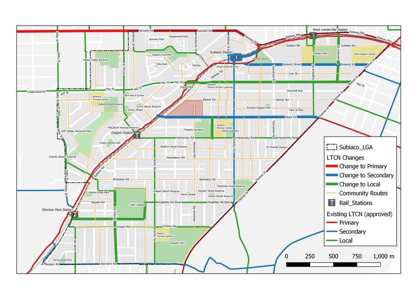
City of Subiaco Bike Plan 2021-2025 | 28Appendix A.LTCN Maps
LTCN maps
Figure A.1: Subiaco Long Term Cycle Network (approved by DoT)
29 | City of Subiaco Bike Plan 2021-2025Figure A.2: Suggested adjustments to Long Term Cycle Network in Subiaco
Figure A.3: Adjusted Subiaco Long Term Cycle Network with community routes (indicative)
City
Cityof SubiacoBike
ofSubiaco BikePlan 2021-2025 |
Plan2021-2025 30241 Rokeby Road SUBIACO WA 6008
PO Box 270 SUBIACO WA 6904
Phone: 08 9237 9222 Fax: 08 9237 9200
Email: city@subiaco.wa.gov.au Website: www.subiaco.wa.gov.au
The document is available online at
www.subiaco.wa.gov.au
This information can be provided in
alternative formats upon request.You can also read