MOKOLO AND CROCODILE (WEST) WATER AUGMENTATION PROJECT (MCWAP) FEASIBILITY STUDY: TECHNICAL MODULE - Eskom
←
→
Page content transcription
If your browser does not render page correctly, please read the page content below

REPORT NUMBER: P RSA A000/00/8909

                Department of Water Affairs

          Chief Directorate: Integrated Water Resource Planning
                       Directorate: Options Analysis

   MOKOLO AND CROCODILE (WEST)
   WATER AUGMENTATION PROJECT
    (MCWAP) FEASIBILITY STUDY:
        TECHNICAL MODULE
                          Project No. WP9528

                    Report 2
            WATER RESOURCES REPORT
              PRE-FEASIBILITY STAGE
                                March 2010

Lead Consultant:        In association with: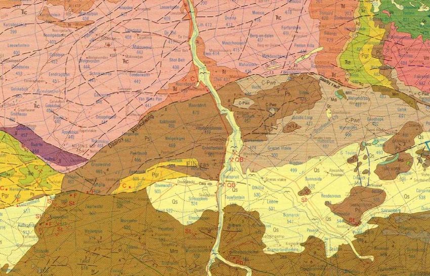
LIST OF REPORTS

    REPORT NO               DESCRIPTION                                    REPORT NAME

                                                FEASIBILITY STAGE

                                                    MCWAP FEASIBILITY          STUDY   TECHNICAL   MODULE
P RSA A000/00/8109            Main Report
                                                    SUMMARY REPORT

P RSA A000/00/8409       Supporting Report 8A       GEOTECHNICAL INVESTIGATIONS PHASE 1

P RSA A000/00/8709       Supporting Report 8B       GEOTECHNICAL INVESTIGATIONS PHASE 2

P RSA A000/008509        Supporting Report 9        TOPOGRAPHICAL SURVEYS

                                                    REQUIREMENTS FOR THE SUSTAINABLE DELIVERY OF
P RSA A000/00/8609       Supporting Report 10
                                                    WATER

P RSA A000/00/8209       Supporting Report 11       PHASE 1 FEASIBILITY STAGE

P RSA A000/00/8309       Supporting Report 12       PHASE 2 FEASIBILITY STAGE

                                             PRE-FEASIBILITY STAGE

P RSA A000/00/8809       Supporting Report 1        WATER REQUIREMENTS

P RSA A000/00/8909       Supporting Report 2        WATER RESOURCES

                                                    GUIDELINES FOR PRELIMINARY SIZING, COSTING AND
P RSA A000/00/9009       Supporting Report 3
                                                    ECONOMIC EVALUATION OF DEVELOPMENT OPTIONS

P RSA A000/00/9109       Supporting Report 4        DAMS, ABSTRACTION WEIRS AND RIVER WORKS

P RSA A000/00/9209       Supporting Report 5        MOKOLO RIVER DEVELOPMENT OPTIONS

P RSA A000/00/9309       Supporting Report 6        WATER TRANSFER SCHEME OPTIONS

P RSA A000/00/9409       Supporting Report 7        SOCIAL AND ENVIRONMENTAL SCREENING

                                                INCEPTION STAGE

P RSA A000/00/9609             Inception            INCEPTION REPORT

                                                    REFERENCE
This report is to be referred to in bibliographies as:

Department: Water Affairs, South Africa, 2008. MOKOLO AND CROCODILE (WEST) WATER
AUGMENTATION PROJECT (MCWAP) Feasibility Study. Pre-Feasibility Study Report 2 Water
Resources.. Prepared by Aurecon in association with Kwezi V3 Engineers, Vela VKE, WRP Consulting
Engineers and specialists.

DWA Report No. P RSA A000/00/8909

 P RSA A000/00/8909                        Water Resources: Pre-Feasibility Stage                   March 2010
MOKOLO AND CROCODILE RIVER (WEST) WATER AUGMENTATION PROJECT FEASIBILITY STUDY

                                         REPORT DETAILS PAGE

Project name:                    Mokolo and Crocodile (West) Water Augmentation Project
                                 (MCWAP)
Report Title:                    Pre-Feasibility Study Report 2 Water Resources
Author:                          J Pienaar
DWA report reference no.:        P RSA A000/00/8909
PSP project reference no.:       WP 9528
Status of report:                Final
First issue:                     November 2008

Final issue:                     March 2010

PSP
Approved for PSP by:

J Pienaar
Study Leader

PROJECT CO-ORDINATION AND MANAGEMENT TEAM
Approved for Project Coordinator by:

SC Vogel
Project Coordinator & Manager

DEPARTMENT OF WATER AFFAIRS (DWA)
Approved for Chief Directorate: Integrated Water Resources Planning by:

OJS van den Berg                                       LS Mabuda
Chief Engineer: Options Analysis North                 Chief Director: Integrated Water
                                                       Resources Planning

P RSA A000/00/8909                 Water Resources: Pre-Feasibility Stage                 March 2010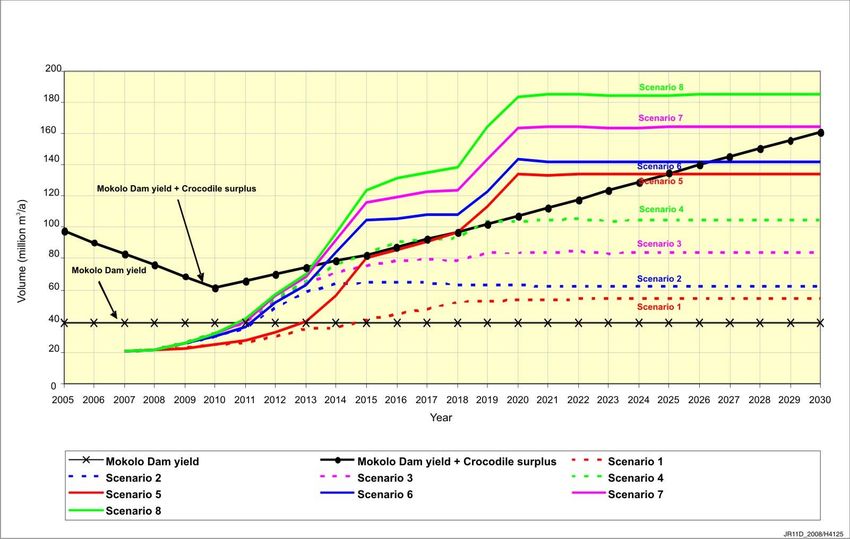
MOKOLO AND CROCODILE RIVER (WEST) WATER AUGMENTATION PROJECT FEASIBILITY STUDY (i)
Preface
The Mokolo (Mogol) River catchment is part of the Limpopo Water Management Area (WMA). The
Mokolo River originates close to Modimolle (Nylstroom) and then drains to the north into the
Limpopo River. The Mokolo Dam (formerly known as the Hans Strijdom Dam) is the largest dam in
the catchment. The dam was constructed in the late 1970s and completed in July 1980, to supply
water to Matimba Power Station, Grootegeluk Mine, Lephalale (Ellisras) Municipality and for
irrigation downstream of the dam. Based on the water infrastructure, the current water availability
and water use allows only limited spare yield existing for future allocations for the anticipated surge
in economic development in the area.
There are a number of planned and anticipated consequential developments in the Lephalale area
associated with the rich coal reserves in the Waterberg coal field for which additional water will be
required. These developments include inter alia the development of further power stations by
Eskom, the potential development of coal to liquid fuel facilities by Sasol and the associated growth
in mining activities and residential development.
The development of new power stations is of high strategic importance with tight timeframes.
Commissioning of the first generation unit will start in September 2010 and additional water needs
to be available by mid 2011 according to the expected water requirements. A solution addressing
the water needs of the Lephalale area must be pursued. The options to augment existing water
supplies include transferring surplus effluent return flows from the Crocodile River (West) / Marico
WMA to Lephalale and the area around Steenbokpan shown on the map indicating the study area
on the following page.
The Department of Water Affairs and Forestry commissioned the MOKOLO AND CROCODILE
RIVER (WEST) WATER AUGMENTATION PROJECT (MCWAP) to analyse the options for
transferring water from the Crocodile River (West). In April 2008 the Technical Module of this study
was awarded to Africon in association with Kwezi V3, Vela VKE and specialists. The focus of the
Technical Module is to investigate the feasibility of options to:
Phase 1: Augment the supply from Mokolo Dam to supply in the growing water requirement
for the interim period until a transfer pipeline from the Crocodile River (West) can be
implemented. The solution must over the long term, optimally utilise the full yield from
Mokolo Dam.
Phase 2: Transfer water from the Crocodile River (West) to the Lephalale area. Options to
phase the capacity of the transfer pipeline (Phases 2A and 2B) must be investigated.
The Technical Module has been programmed to be executed at a Pre-feasibility level of
investigation to identify different options and recommend the preferred schemes, which was
followed by a Feasibility level investigation of the preferred water schemes. Recommendation on
the preferred options for Phase 1 and Phase 2 Schemes were presented to DWA during October
2008 and draft reports were submitted during December 2008. Feasibility Stage of the project
commenced in January 2009 and considered numerous water requirement scenarios, project
phasing and optimisation of pipeline routes. The study team submitted draft Feasibility report
during October 2009 to the MCWAP Main Report in November 2009.
This report (Report 2 – Pre-Feasibility Stage Report: Water Resources, P RSA A000/00/8909)
cover the available surface water resources for the Mokolo and Crocodile River (West) catchment
water areas, as well as ground water resources in the Lephalale area.
P RSA A000/00/8909 Water Resources: Pre-Feasibility Stage March 2010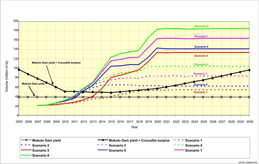
MOKOLO AND CROCODILE RIVER (WEST) WATER AUGMENTATION PROJECT FEASIBILITY STUDY                    (ii)

Executive Summary
Background
The Mokolo River is a major tributary of the Limpopo River and has a total catchment area of over
8 000 km2 with a total natural mean annual runoff (MAR) of almost 300 Million m3/a. The only major
impoundment in the Mokolo River system is the Mokolo Dam which is situated near the town of
Lephalale (formerly Ellisras), approximately 200 km north west of Pretoria. The dam, with a total
gross storage capacity of 145 Million m3 (68% of its natural MAR) was commissioned in 1980 for
the purpose of supplying water to the nearby Grootegeluk coal mine, Matimba dry-cooled power
station, the towns of Lephalale Onverwacht and Marapong and an irrigation scheme located
downstream of the dam. The combined current water allocation from the dam is 27.6 Million m3/a.

There are a number of planned and anticipated consequential developments in the Lephalale area
associated with the rich coal reserves in the Waterberg coal field for which additional water will be
required.

In order to obtain estimates of the current and future water resources capability of the Mokolo River
system, Department of Water Affairs (DWA) - Directorate: National Water Resource Planning,
commissioned the study, Updating the Hydrology and Yield Analysis in the Mokolo River
Catchment (DWA 2008a).

DWA has investigated a number of possible measures to ensure long-term availability of sufficient
water resources in the Mokolo River system, which included most importantly, the implementation
of a transfer scheme to transfer surplus water from the Crocodile River (West) catchment. This
study, i.e. Mokolo and Crocodile (West) Water Augmentation Project (MCWAP) Feasibility Study,
is a continuation of the process aimed at identifying the most economical option for the transfer of
water from the Crocodile West / Marico Water Management Area to the Mokolo Limpopo Water
Management Area.

It is anticipated that the proposed inter-basin transfer from the Crocodile River (West) Catchment,
and elsewhere, (as in ToR) will be commissioned in 2014 whilst initial estimates indicates that
augmentation would be required by 2011. It was thus envisaged that a number of short-term
planning options would need to be investigated in order to bridge shortfalls in water supply to
strategic users that may occur in the interim period. The Water Resources Planning Model
(WRPM) configuration developed as part of the planning analysis (DWA, 2008b) was used for the
purposes of this report.

This report investigates the management options available and determines the period of recovery
needed for the Mokolo Dam. The investigation secondly aims to determine whether the
implementation of curtailments is required in order for the Mokolo Dam to recover in a suitable
period after the implementation of the Crocodile River (West) Transfer Scheme (Phase 2). The
investigation included to determine a failure date of the Mokolo Dam for a possible second period
of drawdown from the dam in the case where the transfer scheme is implemented in two phases.
This will assist DWA in determining the completion date of the second phase (Phase 2B).

Water Resources Availability
The surface water resource availability status quo for the Mokolo and Crocodile River (West), were
summarised. It is based on the results of previous studies.

The Yield Analysis study (DWA, 2008a) determined that the historic firm yield (HFY) of the Mokolo
Dam is 38.7 Million m3/a, which occurs at a high recurrence interval of 1:224 years. The 1:200 yield
available from the Mokolo Dam under current day conditions is 39.1 Million m3/a and was used for
further planning purposes. This is considerably higher than the total allocation from Mokolo Dam of
27,6 Million m3/a.

P RSA A000/00/8909               Water Resources: Pre-Feasibility Stage                    March 2010
MOKOLO AND CROCODILE RIVER (WEST) WATER AUGMENTATION PROJECT FEASIBILITY STUDY                                                    (iii)

The water balances for the Crocodile River (West) System was calculated in the Crocodile River
(West) Reconciliation Strategy (DWA, 2008c) for four water requirement scenarios:
   1. High population growth, medium efficiency water conservation and demand management
       (WC/WDM).
   2. Base population growth, medium efficiency WC/WDM.
   3. Low population growth, medium efficiency WC/WDM.
   4. High population growth, high efficiency WC/WDM.

The results indicated that sufficient water is available to meet the water requirements within the
Crocodile River basin under all of the abovementioned scenarios. Increased surpluses can be
expected to occur for the higher water use scenarios, where larger quantities of water will need to
be transferred to the urban and industrial centres in the upper parts of the basin from the Vaal
River System, with resultant larger volumes of return flow downstream. The scenario of low
population growth with medium efficiency water demand management, the lowest water use
scenario, shows a close balance between water requirements and availability.

The above-mentioned report also assessed the need for water transfers from the Crocodile River
to the Lephalale area for eight development scenarios (Lephalale) by calculating the water
balances for the Crocodile/Lephalale System. A projection of the time when the water requirement
demands for the Lephalale area exceed the combined available water from the Mokolo catchment
and the Crocodile River catchment is provided. This will require additional augmentation from the
Vaal River system, either directly or through transfers from the Vaal River system via the Crocodile
River catchment.

                             250
                                       Scenario 4 April 08
                                       Scenario 4 July 08
                                       Scenario 8 April 08
                             200
                                       Scenario 8 July 08
 Volume (million m /annum)

                             150
 3

                             100

                             50

                              0
                              2009   2011    2013       2015     2017     2019     2021     2023      2025   2027   2029   2031
                                                                              Year
Figure 0-1 Comparison of Water Requirements Scenarios

Planning Analysis
Planning analyses of the Mokolo River System were conducted using the Water Resources
Planning Model (WRPM) that was developed for the entire Mokolo River System in a previous
study (DWA, 2008b).

P RSA A000/00/8909                                           Water Resources: Pre-Feasibility Stage                        March 2010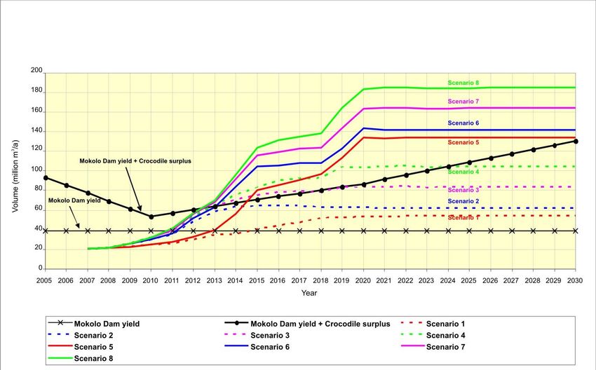
MOKOLO AND CROCODILE RIVER (WEST) WATER AUGMENTATION PROJECT FEASIBILITY STUDY (iv)
Based on the above information, the following scenarios were analysed:
Mokolo Dam Modelling Scenario I: Determine the point of failure of Mokolo Dam during
the interim delivery period based on the revised monthly water requirement projections for
Scenario 8 (including 2% losses added to the user requirements).
Mokolo Dam Modelling Scenario II: Determine the period of recovery needed and whether
the implementation of curtailments is necessary for the Mokolo Dam to recover in a suitable
period after the implementation of the Crocodile River (West) Transfer Scheme. The point of
failure of Mokolo Dam during the second period of drawdown was also determined. The
revised monthly water requirement projections for Scenario 8 (including 2% losses as
above) were used.
Mokolo Dam Modelling Scenario III: Determine the point of failure of Mokolo Dam during
the interim delivery period based on the revised monthly water requirement projections for
Scenario 4, i.e. excluding conversion of coal to liquid fuel (CTL) and associated
developments (including 2% losses).
The Crocodile River (West) Transfer Scheme will transfer treated effluent to the Lephalale supply
area. Due to the low quality of the water transferred to Lephalale, the existing water users will still
need to obtain a portion of good quality water from the Mokolo Dam. As a result, a minimum supply
of water will be supplied from the Mokolo Dam to the existing users during the recovery period,
after the transfer scheme has been implemented (Scenario II).
Scenario Results
The planning analysis results for the three scenarios are summarised in Table 0-1. The Mokolo
dam’s monthly storage projections and the annual irrigation supply projections are presented in the
form of projected probability distribution graphs for the three scenarios in Appendix B. In order to
assess whether the irrigating farmers are being supplied at the same assurance that they have
been supplied in the past, a scenario was developed (Base Scenario) and analysed where
constant water requirements were iteratively imposed on the Mokolo Dam (water requirements
increased with each iteration) to a maximum, where the system on average does not fail over the
projection period. The maximum constant water requirement worked out to 44.18 Million m3/a,
which is similar to the 1:100 year long-term stochastic yield (Irrigation = 16 Million m3/a with 50%
rule). The supply to the irrigation scheme was assessed by calculating the average supply to the
irrigating farmers at 2% (98%), 5% (95%) and 10% (90%) risk (assurance) levels for the period
2017-2030.
Table 0-1 Mokolo Dam Modelling Scenario Results
Mokolo Dam Failure Date Years where Irrigation Supply is
Scenario
(99.5%) Lower than Required Criteria
Mokolo Dam Modelling Scenario I August 2014 2013, 2014
July 2020
Mokolo Dam Modelling Scenario II (Irrigation Scheme curtailed 2013, 2014, 2015, 2019
in 2011)
Mokolo Dam Modelling Scenario III December 2014 2014
P RSA A000/00/8909 Water Resources: Pre-Feasibility Stage March 2010
MOKOLO AND CROCODILE RIVER (WEST) WATER AUGMENTATION PROJECT FEASIBILITY STUDY                     (v)

Based on the results of the planning analysis undertaken it can be concluded that if the water
requirement projection Scenario 8 were to realise, a form of intervention would be required before
August 2014 (Scenario I). The current implementation programme for the inter-basin transfer from
the Crocodile River (West) Catchment is expected to be commissioned by July 2014, being just in
time without any room for delay in the implementation programme thereof. If the development of
the CTL plant and associated commercial and residential developments either do not realise in the
Lephalale area or are postponed to a later date the first failure of the Mokolo Dam will only be
postponed to December 2014 (Scenario III).

With a transfer scheme capacity of only 110 Million m3/a (Phase 2A), active from July 2014, and
with the minimum supply of water being provided from the Mokolo Dam to existing users after the
implementation of the transfer, the Mokolo Dam date of failure is postponed to July 2020
(Scenario II), provided that the Irrigation Scheme is curtailed completely for the year 2011, i.e.
required for DWA to acquire the irrigation allocation in 2011. With the Irrigation Scheme not
curtailed, the Mokolo Dam does not recover after the implementation of Phase 2A of the transfer
scheme and fails in September 2014. A Phase 2B of the transfer scheme would thus need to
be commissioned before July 2020, to ensure sufficient water supply to the water users up to
2030. It must be noted that the planning analysis results indicate that the Mokolo Dam may be
drawn down very low with potential failure in the 2014/2015 period. A possibility thus exists that
some additional curtailment will be required in the period prior to 2014/2015 in order to prevent the
dam from failing, depending on the previous year’s rainfall figures.

The irrigation scheme supply results furthermore indicate that the probability exists that irrigating
farmers will be supplied at assurance levels lower than the irrigation supply Base Scenario during
a number of years. This must be regarded as a potential risk to the DWA and will have to be
investigated in more detail.

It is proposed that a WRPM should be configured to conduct planning analyses on an annual basis
to determine whether it will be necessary to curtail certain users i.e. irrigation scheme, to ensure
sufficient water supply to the strategic users, based on the current year’s water resources situation.

Ground Water Resources
Three ground water orientated studies have been initiated in the Lephalale area and are presently
being completed and final results should be available early in 2010.

The Institute for Groundwater Studies at the Free State University (IGS) is conducting a Water
Research Commission project entitled: An assessment of how water quality and quantity will be
affected by mining method and mining of the Waterberg coal reserves. This study addresses the
potential impact of mining on the occurrence of available groundwater resources.

An Intermediate Reserve Determination study for the Mokolo River Catchment (WMA1) is
presently being completed by Water for Africa in association with Clean Stream. The primary
objective of the study is to implement a RDM assessment yielding recharge results at an
intermediate level of confidence for the Mokolo sub-catchment. Results were not available on
completion of this report.

The first phase of the hydrogeological assessment by DWA of the secondary fractured aquifer by
deep drilling on the fault zones and especially focusing on the Waterberg – Karoo contact fault is
being finalized.

The results indicated that the sustainable yield from the boreholes drilled is estimated at
1.7 Million m3/a. It is further estimated that for a short term two years use 7.19 Million m3/a can be
abstracted but will need a few years to recover. These yields are deemed insufficient to make a
significant contribution to the long term water supply requirement of the area.

P RSA A000/00/8909                Water Resources: Pre-Feasibility Stage                   March 2010
MOKOLO AND CROCODILE RIVER (WEST) WATER AUGMENTATION PROJECT FEASIBILITY STUDY             (vi)

                     LIST OF ABBREVIATION & ACRONYMS

a                    Annum
CMA                  Catchment Management Area
CTL                  Coal-to-Liquid Fuel
DWA                  Department of Water Affairs
FSL                  Full Supply Level
ha                   Hectare
HFY                  Historic Firm Yield
IGS                  Institute for Groundwater Studies
IPPs                 Independent Power Producers
MAR                  Mean Annual Runoff
MCWAP                Mokolo and Crocodile River (West) Water Augmentation Project
MOL                  Minimum Operating Level
RDM                  Resource Determined Measures
MSL                  Mean Sea Level
RI                   Recurrence Intervals
TOR                  Terms of Reference
WC/WDM               Water Conservation and Demand Management
WMA                  Water Management Area
WRC                  Water Research Commission
WRPM                 Water Resources Planning Model
WRYM                 Water Resources Yield Model

P RSA A000/00/8909              Water Resources: Pre-Feasibility Stage              March 2010
MOKOLO AND CROCODILE RIVER (WEST) WATER AUGMENTATION PROJECT FEASIBILITY STUDY (vii)
MOKOLO AND CROCODILE (WEST) WATER AUGMENTATION
PROJECT FEASIBILITY STUDY
TECHNICAL MODULE
TABLE OF CONTENTS
PAGE
1. INTRODUCTION AND BACKGROUND ............................................................................... 1–1
2. SURFACE WATER RESOURCES ....................................................................................... 2–1
2.1. MOKOLO RIVER SYSTEM......................................................................................................... 2–1
2.2. CROCODILE (WEST) RIVER SYSTEM ..................................................................................... 2–2
3. PLANNING ANALYSIS ......................................................................................................... 3–4
3.1. SCENARIO ASSUMPTIONS ...................................................................................................... 3–5
3.2. SCENARIO RESULTS ................................................................................................................ 3–5
3.3. CONCLUSIONS AND RECOMMENDATIONS........................................................................... 3–8
4. GROUNDWATER RESOURCES .......................................................................................... 4–1
4.1. INTRODUCTION ......................................................................................................................... 4–1
4.2. PRIMARY AQUIFER ................................................................................................................... 4–1
4.3. SECONDARY AQUIFER ............................................................................................................ 4–2
4.4. CONCLUSIONS AND RECOMMENDATIONS........................................................................... 4–4
5. REFERENCES ...................................................................................................................... 5–1
LIST OF TABLES
Table 2-1: Mokolo Dam Yield Analysis Results ........................................................................... 2–1
Table 2.2: Lephalale Water Requirement Scenarios ................................................................... 2–2
Table 3.1: Mokolo Dam Modelling Scenario Description ............................................................. 3–5
LIST OF FIGURES
Figure 0-1 Comparison of Water Requirements Scenarios .............................................................. iii
Figure 2-1: Comparison of Water Requirement Scenarios (including irrigation) .................... 2–3
Figure 3-1: Definition of the “Box-and-Whisker”-Plot used in the Projected Annual Probability
Distribution Graphs ....................................................................................................................... 3–6
Figure 4-1: Geological Map Surrounding the Primary Aquifer (Mokolo River) .............................. 4–1
Figure 4-2: Drilling Targets for the DWA Programme ................................................................... 4–2
APPENDICES
Appendix A: Water Balances for the Crocodile / Mokolo Dam System
Appendix B: WRPM Analyses Results (Scenario I & II)
P RSA A000/00/8909 Water Resources: Pre-Feasibility Stage March 2010MOKOLO AND CROCODILE RIVER (WEST) WATER AUGMENTATION PROJECT FEASIBILITY STUDY (1–1)
1. INTRODUCTION AND BACKGROUND
The Lephalale municipal area falls within the Limpopo catchment area. The major part of the
municipality is located in the Limpopo flood plain at an elevation of approximately 800 –
860 m, rising to 1 800 m in the south. The annual rainfall is on average between 380 and
420 mm in the north-west, but in the higher areas to the south rainfall increases to 750 mm.
The Mokolo (previously known as the Mogol) and the Lephalala (also referred to as the
Phalala) Rivers flow through the municipal area to the north, with the Matlabas River flowing
along the south eastern boundary and the Mogalakwena River along the eastern boundary.
All four rivers feed into the Limpopo River which forms the north western border of South
Africa with Botswana.
Large parts of the Mokolo River catchment area are located on the Waterberg coalfields
where, according to preliminary estimates, almost half of South Africa’s in-situ coal reserves
are situated. As such, the Waterberg has long been considered the country’s major coal
resource for the future, especially once the current mining areas in the Witbank-Highveld
coalfields of the Mpumalanga Province have been depleted.
The Mokolo Dam with a gross capacity of 146 Million m3 was built in the Mokolo River
(completed in 1980), and provides water to the Lephalale town, Matimba and Exxaro coal
mines, as well as to the irrigation farmers between the dam and the Limpopo River. The
present water allocations, totalling 27,6 Million m3/a, are as follows:
Mining - Exxaro (and related municipal requirements) : 10.1 Million m3/a
Power station (and Marapong Township requirements) : 7.1 Million m3/a
Irrigation : 10.4 Million m3/a
The population of Lephalale can be grouped according to the geographic area, with the
majority residing in villages within the Lephalala River catchment, the urban population found
in the Lephalale/Onverwacht/Marapong towns between the Mokolo River and the coal mine,
and the farming community living dispersed over the municipal area.
There are a number of planned and anticipated consequential developments in the Lephalale
area associated with the rich coal reserves in the Waterberg coal field for which additional
water will be required. These developments include:
Construction of Eskom’s Medupi Power Station presently underway;
Development of further Eskom Power Station;
Possible development of power stations by Independent Power Producers (IPPs);
Extension of the Grootegeluk mining operations and further mines;
Possible petrochemical industries to be developed around the coal field further west
of Lephalale;
Possible exploitation of gas resources; and
Accelerated growth in the population in the area.
The Mokolo River catchment yield is sufficient for current water use requirements, although
no specific allowance exists for the Ecological Reserve. The abovementioned future
developments will require additional water which cannot be supplied from the surface
resources within the Mokolo River catchment of the Limpopo Water Management Area
(WMA). This report therefore addresses the potential water resources that can be utilised to
augment the existing water resources. These resources are the following:
The transfer of surplus treated return flows from the Crocodile River (West) / Marico
WMA; and
Groundwater resources in the Limpopo WMA.
P RSA A000/00/8909 Water Resources: Pre-Feasibility Stage March 2010MOKOLO AND CROCODILE RIVER (WEST) WATER AUGMENTATION PROJECT FEASIBILITY STUDY (1–2)
In view of the above situation, the Department of Water Affairs (DWA) has investigated a
number of possible intervention measures to ensure long-term availability of sufficient water
resources in the Mokolo River system, which included most importantly, the implementation
of a transfer scheme to import surplus water from the Crocodile River (West) catchment. This
study, i.e. Mokolo and Crocodile River (West) Water Augmentation Project (MCWAP) Pre-
Feasibility Study is a continuation of the process aimed at identifying the most economic
option for the transfer of water from the Crocodile River West / Marico WMA to the Limpopo
WMA.
In order to obtain estimates of the current and future water resources capability of the Mokolo
River system, the DWA, Directorate: National Water Resource Planning commissioned the
Updating the Hydrology and Yield Analysis in the Mokolo River Catchment. The study
included the following two components:
Updating the Hydrology and Yield Analysis in the Mokolo River Catchment: Yield
Analysis (WRYM) study (DWA, 2008a); and
Updating the Hydrology and Yield Analysis in the Mokolo River Catchment: Planning
Analysis (WRPM) study (DWA, 2008b). This component included a planning
analysis with the main objective of developing a detailed Water Resources Planning
Model (WRPM) configuration of the entire Mokolo River system.
Initial results from the planning analysis (DWA, 2008b) indicated that augmentation would be
required by 2011. As it is anticipated that the proposed inter-basin transfer from the
Crocodile River (West) Catchment will be commissioned in 2014 and it was thus envisaged
that a number of short-term planning options would need to be investigated for bridging
shortfalls to strategic users that may occur in the interim period. The WRPM configuration
developed as part of the planning analysis (DWA, 2008b) was used for the purposes of this
report to investigate the management options required, and also to determine the period of
recovery needed for the Mokolo Dam and whether the implementation of curtailments is
necessary for the Mokolo Dam to recover in a suitable period after the implementation of the
Crocodile River (West) Transfer Scheme (Phase 2). The failure date of the Mokolo Dam was
also investigated for a possible second period of drawdown for the option where the transfer
scheme is implemented in two phases i.e. date when the second phase of the scheme would
be required (Phase 2B).
P RSA A000/00/8909 Water Resources: Pre-Feasibility Stage March 2010MOKOLO AND CROCODILE RIVER (WEST) WATER AUGMENTATION PROJECT FEASIBILITY STUDY (2–1)
2. SURFACE WATER RESOURCES
The purpose of this section is to describe the status quo regarding surface water resources.
The objective is to provide a summary of previous studies. Refer to Section 5 hereinafter.
2.1. Mokolo River System
The Mokolo River is a major tributary of the Limpopo River and has a total catchment area of
8 380 km2 with a total natural mean annual runoff (MAR) of almost 300 Million m3/a. The
catchment stretches from the Waterberg Mountains through the upper reaches of the Sand
River, and includes the Mokolo Dam and a number of small tributaries that join the main
Mokolo River up to its confluence with the Limpopo River. The only major impoundment in
the Mokolo River system is the Mokolo Dam, which is situated near the town of Lephalale
(formerly Ellisras), approximately 200 km north west of Pretoria. The dam, with a total gross
storage capacity of 145 Million m3 (68% of its natural MAR) was commissioned in 1980 for
the purpose of supplying water to the nearby Grootegeluk coal mine, Matimba dry-cooled
power station, the towns of Lephalale Onverwacht and Marapong and an irrigation scheme
located downstream of the dam.
The combined current water allocation from the dam is 27.6 Million m3/a, which includes the
Gootegeluk coal mine (3.4 Million m3/a), Matimba (3.6 Million m3/a), Medupi Power Station
(3.4 Million m3/a) Lephalale/Onverwacht towns (3.3 Million m3/a), Marapong township
(0.5 Million m3/a) and the Irrigation Scheme (10,4 Million m3/a).
The main objective of the Yield Analysis study (DWA, 2008a) was to determine the current
water resources capability of the Mokolo River system. This process included a detailed
system analysis with the main objective of assessing the long-term yield of the Mokolo Dam
for a variety of situations, based on the updated and extended hydrology covering the
selected study period of 1920 to 2003 hydrological years (i.e. October 1920 to September
2004), which was developed as part of the study. The yield analyses results were used in
this study, and the reader is referred to the Yield Analysis (WRYM) report (DWA, 2008a), for
further details on the updating of the hydrology, physical system components and the details
of the yield analyses conducted.
The Mokolo Dam yield analysis results for the scenario with the most reliable representation
of the current-day situation are summarised in Table 2-1 below. The Historic Firm Yield
(HFY) and the Long-term stochastic yields at the various recurrence intervals (RI) are
illustrated. The scenario included the catchment developments upstream of Mokolo Dam
(at the 2004 development level), which most importantly included the surface water and
groundwater irrigation, small storage dams, weirs and the gravel pits associated with mining
activities.
Table 2-1: Mokolo Dam Yield Analysis Results
HFY Yield (Million m3/a), at indicated RI
(Million m3/a) RI (years) 1:200 1:100 1:50 1:20
38.7 1:224 39.1 44.6 50.7 66.8
From the results it can be seen that the HFY of the Mokolo Dam is 38.7 Million m3/a, which
occurs at a high RI of 1:224 years. The 1:200 year firm yield available from the Mokolo Dam
under current day conditions of land and water use is 39.1 Million m3/a and was used for
further planning purposes. This is considerably higher than the total allocation from Mokolo
Dam of 27,6 Million m3/a. A total of 38.7 Million m3/a, including losses, is therefore available
to supply the Lephalale area on a long-term basis.
Refer to Pre-Feasibility Study: Report 1 Water Requirements (P RSA A000/00/8809) for
detail on future water requirements.
P RSA A000/00/8909 Water Resources: Pre-Feasibility Stage March 2010MOKOLO AND CROCODILE RIVER (WEST) WATER AUGMENTATION PROJECT FEASIBILITY STUDY (2–2)
2.2. Crocodile (West) River System
The water balances for the Crocodile (West) River System was calculated in the Crocodile
River (West) Reconciliation Strategy (DWA, 2008c) for four water requirement scenarios:
1. High population growth, medium efficiency water conservation and demand
management (WC/WDM).
2. Base population growth, medium efficiency WC/WDM.
3. Low population growth, medium efficiency WC/WDM.
4. High population growth, high efficiency WC/WDM.
The results indicated that sufficient water is available to meet the water requirements within
the Crocodile River basin under all of the abovementioned scenarios. Increased surpluses
can be expected to occur for the higher water use scenarios, where larger quantities of water
will need to be transferred to the urban and industrial centres in the upper parts of the basin
from the Vaal River System, with resultant larger volumes of return flow downstream. The
scenario of low population growth with medium efficiency water demand management, the
lowest water use scenario, shows a close balance between water requirements and
availability.
The need for water transfers from the Crocodile River to the Lephalale area was assessed in
the Crocodile River (West) Reconciliation Strategy, Version 1, (DWA, 2008c) for the eight
development scenarios (Lephalale) described in Table 2.2. Future developments at
Lephalale include expansions in the mining sector, as well as possible new developments by
Eskom and Sasol (Coal to Liquid Fuel (CTL) Plant) in the area. The first four scenarios in
Table 2.2 exclude the CTL plants and its associated developments. Scenario 1 - Scenario 4
are duplicated for the case where the CTL plants and associated developments take place in
Lephalale (Scenario 5 - Scenario 8).
Table 2.2: Lephalale Water Requirement Scenarios
Scenario Description
Scenario 1 Matimba Power Station (existing technology), Medupi Power Station (existing
technology), Exxaro supply coal for two power stations, Lephalale town for two
power stations.
Scenario 2 Matimba Power Station (existing technology), Medupi Power Station with flue gas
desulphurisation (FGD), 1 additional new power station with FGD technology, coal
supply to 3 power stations, Lephalale town for 3 power stations.
Scenario 3 Matimba Power Station (existing technology), Medupi Power Station with FGD
technology, 1 additional new power station with FGD technology, 2 additional new
power stations with fluidised bed combustion (FBC), coal supply to 5 power stations,
Lephalale town for 5 power stations.
Scenario 4 Matimba Power Station (existing technology), Medupi Power Station with FGD
technology, 3 additional new power stations with FGD, coal supply to 5 power
stations, Lephalale town for 5 power stations.
Scenario 5 Scenario 1 + Coal to Liquid Plants + mine + township.
Scenario 6 Scenario 2 + Sasol (Coal to Liquid Plant) + mine + township.
Scenario 7 Scenario 3 + Sasol (Coal to Liquid Plant) + mine + township.
Scenario 8 Scenario 4 + Sasol (Coal to Liquid Plant) + mine + township.
P RSA A000/00/8909 Water Resources: Pre-Feasibility Stage March 2010MOKOLO AND CROCODILE RIVER (WEST) WATER AUGMENTATION PROJECT FEASIBILITY STUDY (2–3)
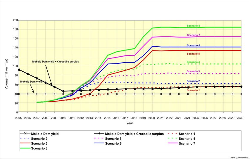
Water balances were also calculated for the Crocodile River/Mokolo Dam System where the
need for water transfers from the Crocodile River to the Lephalale area was assessed for
each of the Lephalale water requirement scenarios described above. The water balance
diagrams for the Crocodile River/Mokolo Dam system are illustrated in Figures A-1 to A-4 in
Appendix A (sourced from the Crocodile River (West) Reconciliation Strategy, Version 1,
(DWA, 2008c)) for the described scenarios. The yield of the Mokolo Dam is shown in the
figures to indicate when the requirements in the Lephalale area exceed the available yield
and thus indicate when additional augmentation is required i.e. transfer of surplus treated
effluent from the Crocodile.
The projection including both the Mokolo Dam yield and the surplus effluent from the
Crocodile is also illustrated and where the water requirement projection scenarios of
Lephalale cross this line gives an indication when requirements in the Lephalale area exceed
the water availability in the Mokolo catchment together with the surplus available from the
Crocodile River catchment. This will require additional augmentation from the Vaal River
system, either directly or through transfers from the Vaal River system via the Crocodile
River catchment.
A decision was made by the study team that water requirement Scenario 4 and Scenario 8
(worst case scenario) will be used for planning purposes. It should be noted that both the
water requirements scenarios illustrated in Figures A-1 to A-4 were revised as part of this
study as updated information became available from the users. The reader is referred to the
Water Requirements Report 1 (P RSA A000/00/8909) of this study for further details.
A comparison of the original and revised Scenario 4 and Scenario 8 water requirements
(including irrigation) are illustrated in Figure 2.1.
250
Scenario 4 April 08
Scenario 4 July 08
Scenario 8 April 08
200
Scenario 8 July 08
Volume (million m3/annum)
150
100
50
0
2009 2011 2013 2015 2017 2019 2021 2023 2025 2027 2029 2031
Year
Figure 2-1: Comparison of Water Requirement Scenarios (including irrigation)
The projections are very similar in the initial period and larger differences occur toward the
end of the projection period with the revised Scenario 4 and Scenario 8 ending at
29 Million m3/a and 43 Million m3/a higher than the original projections. The implementation
of the CTL projects has also been delayed slightly as illustrated by the revised Scenario 8
water requirement projection.
P RSA A000/00/8909 Water Resources: Pre-Feasibility Stage March 2010MOKOLO AND CROCODILE RIVER (WEST) WATER AUGMENTATION PROJECT FEASIBILITY STUDY (3–4)
3. PLANNING ANALYSIS
Planning analyses of the Mokolo River System were conducted using the Water Resources
Planning Model (WRPM) that had been configured for the entire Mokolo River System in a
previous study (DWA, 2008b). The reader is referred to the Updating the Hydrology and
Yield Analysis in the Mokolo River Catchment Study: Planning Analysis (WRPM) Report
(DWA, 2008b) for background on the WRPM and details of the WRPM configuration of the
Mokolo River System and the functioning thereof.
It was assumed that the Crocodile River (West) Transfer Scheme will be implemented in two
phases. The capacity of the first phase of the scheme (Phase 2A) is 110 Million m3/a and the
commissioning date of the scheme is July 2014, as indicated by the study team. Based on
the above information, the following scenarios were analysed:
Mokolo Dam Modelling Scenario I: Determine the point of failure of Mokolo Dam
during the interim delivery period based on the revised monthly water requirement
projections for Scenario 8 (including 2% losses added to the user requirements).
Mokolo Dam Modelling Scenario II: Determine the period of recovery needed and
whether the implementation of curtailments is necessary for the Mokolo Dam to
recover in a suitable period after the implementation of the Crocodile River (West)
Transfer Scheme. The point of failure of Mokolo Dam during the second period of
drawdown was also determined. The revised monthly water requirement projections
for Scenario 8 (including 2% losses added to the user requirements) were used.
Mokolo Dam Modelling Scenario III: Determine the point of failure of Mokolo Dam
during the interim delivery period based on the revised monthly water requirement
projections for Scenario 4, i.e. excluding CTL and associated developments
(including 2% losses added to the user requirements).
Several planning analyses were conducted where various management options were
investigated using the original annual water requirement projections. The results were
however superseded with the results of the above scenarios that were conducted with the
revised monthly water requirement projections and an increased minimum operating level
(MOL) of the dam (increased from 871.82 to 881.5 m above see level). The MOL was
increased based on the investigations carried out for the design of the new pump station,
conducted as part of the study.
It must be noted that the planning analyses undertaken in the WRPM were based on the
following:
An analysis period of 23 years, from 1 May 2008 to 30 April 2030.
May was implemented as the decision month for the Mokolo River System as it
signals the start of the dry season.
Using the PARAM.DAT-file developed as part of the stochastic stream flow analysis
and based on 1 000 stochastically generated sequences for the above 23-year
period.
The current storage characteristics of Mokolo Dam were applied (i.e. un-raised),
with a full supply level (FSL) of 911.98 m above mean sea level (MSL) , a full supply
capacity of 145.92 Mm3 and a minimum operating level of 881.50 m above MSL.
The storage level of Mokolo Dam on 1 May 2008, which was at the start of the
WRPM analyses period, was at the FSL of 911.98 m above sea level. Since no
dependable information was available for the small storage dams, weirs and gravel
pits it was assumed that these were also at FSL at the start of the analysis. The
assumption was considered reasonable in view of the storage condition of Mokolo
Dam at the same time, as well as the fact that May is at the end of the wet season in
the Mokolo River System.
P RSA A000/00/8909 Water Resources: Pre-Feasibility Stage March 2010MOKOLO AND CROCODILE RIVER (WEST) WATER AUGMENTATION PROJECT FEASIBILITY STUDY (3–5)
3.1. Scenario Assumptions
The components included in each of the scenarios are illustrated in Table 3.1 below. The
irrigation scheme located downstream of the Mokolo Dam is supplied through releases that
are made from the dam with a current allocation of 10.4 Million m3/a. The current agreement
between the irrigating farmers and the operators of the dam is that 16 Million m3/a is released
provided that the Mokolo Dam is at a level above 50% of its live full supply capacity. If the
dam is below 50% of its live full supply level no releases are made. The WRPM was
configured to simulate the current agreement of 16 Million m3/a (50% rule) releases to the
irrigating farmers in the two scenarios. The effect of the latter rule on the remaining yield of
the Dam was found to be about the same, although the effects on the down stream river flow
are quite different.
The Crocodile River (West) Transfer Scheme will transfer treated effluent to the Lephalale
supply area. Due to the low quality of the water transferred to Lephalale, the existing water
users will still need to obtain a portion of good quality water from the Mokolo Dam. As a
result, a minimum supply of water will be supplied from the Mokolo Dam to the specific users
during the recovery period after the transfer scheme has been implemented. The users and
their respective minimum supply volumes from Mokolo Dam during the recovery period as
specified by the users are illustrated in Table 3.1 (Scenario II Description). The irrigation
scheme is supplied through releases from the Mokolo Dam and is thus also supplied from
the Mokolo Dam during the recovery period.
Table 3.1: Mokolo Dam Modelling Scenario Description
Scenario Description
- Updated Scenario 8 monthly water requirement projection (including
Mokolo Dam Modelling 2% losses)
Scenario I - Updated Mokolo Dam MOL of 881.5 m above sea level
- Irrigation scheme requirement = 16 Million m3/a (50% storage rule)
- Updated Scenario 8 monthly water requirement projection (including
2% losses)
- Updated Mokolo Dam MOL of 881.5 m above sea level
Mokolo Dam Modelling - Crocodile River (West) Transfer active from July 2014 with a
Scenario II capacity of 110 Million m3/a
- Minimum supply from the Mokolo Dam during recovery period:
Irrigation = 16 Million m3/a (50% storage rule), Eskom = 3.6 Million
m3/a, Exxaro = 2.5 Million m3/a, Lephalale = 11.9 Million m3/a
- Updated Scenario 4 monthly water requirement projection (including
Mokolo Dam Modelling 2% losses)
Scenario III - Updated Mokolo Dam MOL of 881.5 m above sea level
- Irrigation scheme requirement = 16 Million m3/a (50% storage rule)
3.2. Scenario Results
The planning analysis results are presented in the form of projected probability distribution
graphs, which are expressed using a “box-and-whisker”-plot, the definition of which is shown
in Error! Reference source not found..
P RSA A000/00/8909 Water Resources: Pre-Feasibility Stage March 2010MOKOLO AND CROCODILE RIVER (WEST) WATER AUGMENTATION PROJECT FEASIBILITY STUDY (3–6)
Max. value
0.5 %
1%
5%
25 %
Probability
distribution
(exceedance
50 %
probabilities)
75 %
95 %
99 %
99.5 %
Min. value
Figure 3-1: Definition of the “Box-and-Whisker”-Plot used in the Projected Annual
Probability Distribution Graphs
3.2.1. Mokolo Dam Modelling Scenario I
The planning analysis results of Scenario I are presented in Figures B-1 and B-2 of
Appendix B in the form of projected probability distribution graphs of the following, for the
analysis period of 23 years from 1 May 2008 to 30 April 2030:
Monthly storage volumes in Mokolo Dam, shown in units of million m3
Annual volumes supplied to the irrigation scheme in units of million m3
The Mokolo Dam monthly storage volume projection presented in Figure B-1, illustrates that
according to the assurance of supply criteria of 99.5% (i.e. risk of non supply of 1 in 200
years) the dam fails in August 2014. Since the Crocodile River (West) Transfer Scheme is
scheduled to be commissioned by July 2014, no additional short term management options
needed to be investigated for implementation, although very little time is available as buffer
to accommodate any delays in the implementation of Phase 2A of the transfer scheme.
The simulated failure date is later than the date indicted in the Updating the Hydrology and
Yield Analysis in the Mokolo River Catchment Study: Planning Analysis (WRPM) Report
(DWA, 2008b), i.e. 2011. The reason for this is that the Mokolo Dam Modelling Scenario I
included the revised Scenario 8 water requirement projection, where the growth in water
requirements is slightly delayed due the delay in the implementation of the CTL plants. The
monthly values of the revised water requirement projection were also used in Mokolo Dam
Modelling Scenario I whereas an annual water requirement projection was used in the
previous analysis. The irrigation scheme demand of 16 Million m3/a with the 50% live full
supply capacity rule (current agreement) was used in the Mokolo Dam Modelling
Scenario I simulation, whereas the irrigation scheme demand of 10.4 Million m3/a, which is
supplied irrespective for the Mokolo Dam storage capacity, was used in the previous
planning analysis. The differences described above all contributed to the postponed Mokolo
Dam failure date of August 2014.
P RSA A000/00/8909 Water Resources: Pre-Feasibility Stage March 2010MOKOLO AND CROCODILE RIVER (WEST) WATER AUGMENTATION PROJECT FEASIBILITY STUDY (3–7)
In order to assess whether the irrigating farmers are being supplied at the same assurance
that they have been supplied in the past, a scenario was developed (Base Scenario) and
analysed where constant water requirements were iteratively imposed on the Mokolo Dam
(water requirements increased with each iteration) to a maximum, where the system on
average does not fail over the projection period. The maximum constant water requirement
worked out to 44.18 Million m3/a, which is similar to the 1:100 year long-term stochastic yield
(Irrigation = 16 Million m3/a with 50% rule). The supply to the irrigation scheme was assessed
by calculating the average supply to the irrigating farmers at 2% (98%), 5% (95%) and 10%
(90%) risk (assurance) levels for the period 2017-2030. This was regarded as the criteria
against which the supply to the irrigators should be supplied and could be compared to the
scenario results.
The average 2%, 5% and 10% irrigation supply volumes from the base scenario were plotted
on the irrigation supply projection of Mokolo Dam Modelling Scenario I (Figure B- 5. It can
be seen that the 5% (95%) assurance value in the year 2013 is below the average 5% line
indicating that the irrigators are supplied at a lower assurance than usual in that year.
3.2.2. Mokolo Dam Modelling Scenario II
The planning analysis results of Mokolo Dam Modelling Scenario II are presented in
Figures B-3 to B-5 of Appendix B in the form of projected probability distribution graphs of
the following, for the analysis period of 23 years from 1 May 2008 to 30 April 2030:
Monthly storage volumes in Mokolo Dam, shown in units of million m3
Annual volumes supplied to the irrigation scheme in units of million m3
The Mokolo Dam monthly storage volume projection presented in Figure B-3, illustrates that,
according to the assurance of supply criteria of 99.5 % (i.e. risk of non supply of 1 in 200
years), the dam fails in September 2014 and then recovers again in January 2015 due to the
implementation of the Crocodile River (West) Transfer Scheme with a capacity of 110 Mm3/a,
which is active from July 2014. As a result, it was necessary to curtail the Irrigation Scheme
completely for a year in 2011, in order for the dam to recover after the implementation of the
transfer scheme without failing. Curtailing the irrigation at a later stage i.e. 2012 or 2013 was
not effective in preventing the system from failing, as the irrigation was already curtailed in
some instances due to a combination of the lower Mokolo Dam storage levels and the
irrigation operating rule (16 Million m3/a is released provided that the Mokolo Dam is at a
level above 50% of its live full supply capacity). The Mokolo Dam monthly storage volume
projection, with the irrigating farmers curtailed completely in 2011, is illustrated in Figure B-4.
It can be seen that the 99.5% failure date has been postponed to July 2020, which implies
that the second phase of the Crocodile (West) Transfer Scheme (Phase 2B) needs to be
planned to be commissioned before July 2020. The results also illustrate that the dam may
be drawn very low in the 2014/2015 period and the possibility thus exists that additional
curtailments might need to be imposed prior to this period, depending on the previous year’s
rainfall figures.
The average 2%, 5% and 10% risk irrigation supply volumes from the base scenario were
plotted on the irrigation supply projection of Mokolo Dam Modelling Scenario II (Figure B-
5). It can be seen that the 5% (95%) assurance is below the average 5% line in the years
2013, 2014, 2015 and 2019 indicating that the irrigators are supplied at a lower assurance
than usual in those years. The curtailments imposed on the Irrigation Scheme in 2011 is also
illustrated, i.e. no supply to the irrigating farmers.
3.2.3. Mokolo Dam Modelling Scenario III
Scenario III was simulated in order to assess the impact on the Mokolo Dam failure date if
the development of the CTL plants and associated developments do not realise in the
Lephalale area, i.e. water requirement Scenario 4 (including 2% losses). The Mokolo Dam
monthly storage volume projection presented in Figure B-6, illustrates that according to the
P RSA A000/00/8909 Water Resources: Pre-Feasibility Stage March 2010MOKOLO AND CROCODILE RIVER (WEST) WATER AUGMENTATION PROJECT FEASIBILITY STUDY (3–8)
assurance of supply criteria of 99.5% the dam fails in December 2014, i.e. postponed by
4 months. The impact on the date of failure is not that severe as the first CTL plant is
scheduled to be commissioned only in approximately 2015 with substantial volumes of water
only required from 2016 onwards.
The average 2%, 5% and 10% risk irrigation supply volumes from the base scenario were
plotted on the irrigation supply projection of Mokolo Dam Modelling Scenario III (Figure B-
7). It can be seen that the 5% (95%) assurance is below the average 5% line from 2014
onwards, when the dam fails, indicating that the irrigating farmers are supplied according to
this criteria before 2014.
3.3. Conclusions and Recommendations
Based on the results of the planning analysis undertaken it can be concluded that if the water
requirement projection Scenario 8 were to realise, a form of intervention would be required
before August 2014. The current implementation programme for the first phase inter-basin
transfer from the Crocodile River (West) Catchment is expected to be commissioned by
July 2014, being just in time without any room for delay in the implementation programme
thereof. If the development of the CTL plant and associated commercial and residential
developments either do not realise in the Lephalale area or are postponed to a later date the
first failure of the Mokolo Dam will only be postponed to December 2014
With a transfer scheme capacity of 110 Million m3/a for Phase 2A, active from July 2014 and
with the minimum supply of water being provided from the Mokolo Dam to existing users
after the implementation of the transfer, the Mokolo Dam date of failure is postponed to
July 2020, provided that the Irrigation Scheme is curtailed completely during the year 2011,
i.e. required DWA to acquire the irrigation allocation in 2011. With the Irrigation Scheme not
curtailed, the Mokolo Dam does not recover after the implementation of a Phase 2A of the
transfer scheme and fails in September 2014. A Phase 2B of the transfer scheme would
thus need to be commissioned before July 2020, to ensure sufficient water supply to the
water users up to 2030. It must be noted that the planning analysis results indicate that the
Mokolo Dam may be drawn down very low with potential failure in the 2014/2015 period.
A possibility thus exists that some additional curtailment will be required in the period prior to
2014/205 in order to prevent the dam from failing, depending on the previous year’s rainfall
season.
The irrigation scheme supply results furthermore indicate that the probability exists for
irrigators to be supplied at assurance levels lower than the Base Scenario during a number
of years. This must be regarded as a potential risk to the DWA and will have to be
investigated in more detail.
It is proposed that a WRPM should be configured to conduct planning analyses on an annual
basis to determine whether it will be necessary to curtail certain users, i.e. irrigation scheme,
to ensure sufficient water supply to the strategic users, based on the current year’s water
resources situation. This should be available when the new Phase 1A (or parts of it) supply
from Mokolo Dam is put to use.
P RSA A000/00/8909 Water Resources: Pre-Feasibility Stage March 2010MOKOLO AND CROCODILE RIVER (WEST) WATER AUGMENTATION PROJECT FEASIBILITY STUDY (4–1)
4. GROUNDWATER RESOURCES
4.1. Introduction
The objective of this study is to assess at desktop level the available groundwater resources
in the Lephalale area to augment the water supplies in the interim period when construction
of the transfer pipeline from Crocodile River (West) is taking place. The options being
considered to augment the current water supplies in the Lephalale area will take a number of
years to be completed and fully operational. Groundwater resources are therefore
considered as a further supply option to augment current supplies.
A previous desktop study on the groundwater potential for the Mokolo River catchment was
done for the Department of Water Affairs and Forestry (DWA 2000). The description below
is a summary of the groundwater potential in the area taken from this study and those
referenced at the end of this report
4.2. Primary Aquifer
A primary aquifer occurs in the Mokolo River alluvium. The basin of the Mokolo River
consists of coarse-grained alluvial sand with inter-bedded lenses of finer clay/shale material.
Previous limited investigations done by DWA indicated this primary aquifer in the riverbed
has a thickness varying between 5 m to greater than 25 m. (Fanie Botha pers. com.) This
aquifer is primarily used for irrigation and is recharged by the river during the rainy season.
The quality of the water in this aquifer is regarded as good with TDS < 500 mg/ℓ which makes
it attractive as a source.
Figure 4-1: Geological Map Surrounding the Primary Aquifer (Mokolo River)
P RSA A000/00/8909 Water Resources: Pre-Feasibility Stage March 2010You can also read