Te Mihi Expansion Preliminary Site Investigation (Ground Contamination) - Taupo ...
←
→
Page content transcription
If your browser does not render page correctly, please read the page content below
Te Mihi Expansion

Preliminary Site Investigation (Ground Contamination)

                                     CONTACT ENERGY LTD

                                        WWLA0429 | Rev. 2

                                            6 August 2021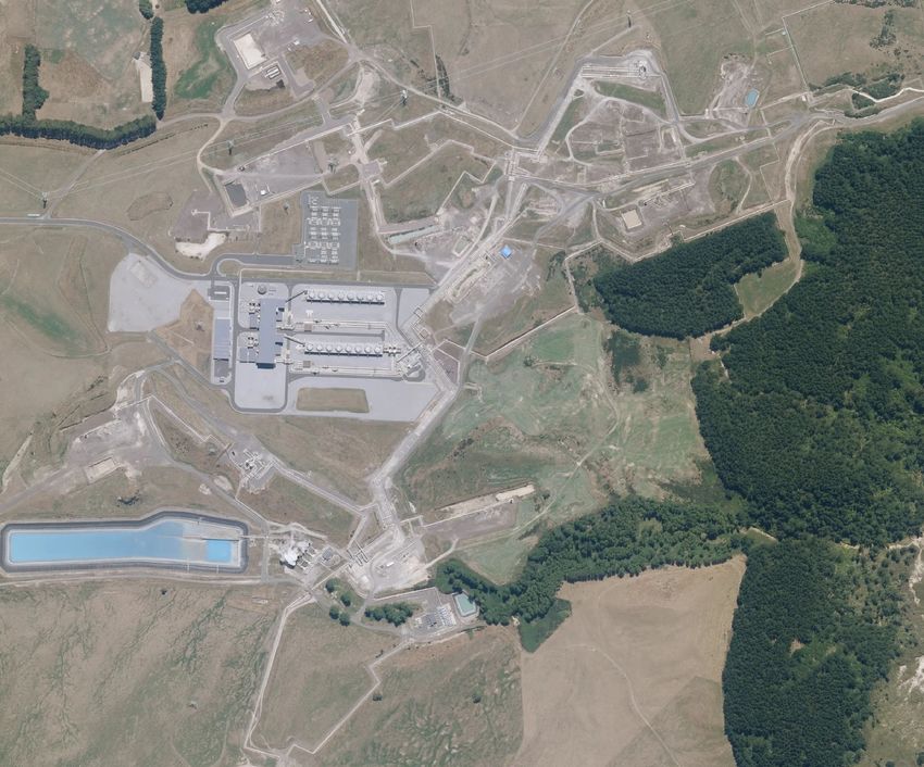
Te Mihi Expansion
Preliminary Site Investigation (Ground Contamination)

Te Mihi Expansion

Project no:                   WWLA0429
Document title:               Preliminary Site Investigation (Ground Contamination)
Revision:                     2
Date:                         6 August 2021
Client name:                  Contact Energy Ltd
Project manager:              Wendi Williamson
Author(s):                    Lauren Windross
File name:                    G:\Shared drives\Projects\Contact Energy\WWLA0429_Te Mihi Expansion\Deliverables\WWLA_Te Mihi
                              PSI_Rev 2_060821.docx

Williamson Water & Land Advisory

PO Box 314,
Kumeu 0841,
Auckland
T +64 21 613 408

                                                                                                      Document history and status

Rev Date                     Description                                                        Prepared                    Reviewed

1      28 July 2021          Ground Contamination Investigation                                 Lauren Windross             Wendi Williamson

2      6 August 2021         Ground Contamination Investigation                                  Wendi Williamson           Wendi Williamson

                                                                                                                    Distribution of copies

Rev Date issued              Issued to                                                          Comments

1      28 July 2021          Contact Energy Ltd

2      6 August 2021         Contact Energy Ltd, Michell Daysh Ltd                              For RC

Cover image: https://www.nzherald.co.nz/rotorua-daily-post/news/te-mihi-goes-full-steam-ahead/5C6UBF5WGPW5IGDAXIORNGILSU/

Williamson Water & Land Advisory Limited                                                                                                       i
Te Mihi Expansion
Preliminary Site Investigation (Ground Contamination)

Investigation Summary
WWLA has undertaken this Preliminary Site Investigation (PSI) to support a resource consent application under
the NESCS for the upgrade of Te Mihi Geothermal Power Station. The PSI aims to understand the potential for
contamination to exist within the development sites and the implications of potential contamination on
consenting and earthworks.

The key findings of this report are:

 History and        An assessment of past land uses against potentially contaminating activities identified on the Ministry for the
 potential for      Environment’s Hazardous Activities and Industries List (HAIL) was made following a review of available historical land
 contamination      use information. The site history review found:
 [Section 3]        •   The site was vacant farmland until 2011 with only isolated geothermal infrastructure (i.e. test wells) present.
                    •   The main period of construction for the power station was from 2011 to 2013. The station was commissioned in
                        2014 and the sites have remained largely unchanged since.
                    •   Earthworks plans show that significant cut-to-fill works were undertaken in the vicinity of the THI A site, meaning
                        that any potential contamination that would have existed pre-works has likely now been removed. THI B has not
                        been earthworked.
                    •   Council records and site plans identify a number of potentially contaminating activities on the wider property or
                        surrounding properties. However, the potential for contamination from these to impact the development area is
                        negligible due to either their distance from site and/ or the modern nature of the facilities (i.e. for adjacent diesel
                        storage).
                    While power stations are considered a HAIL activity (Activity B4: Power station, switchyards and
                    substations), no HAIL activities have occurred in the proposed development areas.

 Conceptual site    A conceptual site model (CSM) can be developed to identify possible risks to people and the environment if
 model              contamination is present. A CSM illustrates potential sources of contamination, routes of exposure (pathways), and
 [Section 4]        the receptors (people or the environment) that may be affected by contaminants moving along those pathways.
                    The CSM for the proposed expansion works shows that as there is no source of contamination present, there is no
                    complete pathway for contamination effects on people or the environment (receptors).

 Consenting         Consent is not required under the National Environmental Standards for Assessing and Managing Contaminants in
 requirements       Soil to Protect Human Health (NESC) Regulation (2011) because while the wider power station is a HAIL activity
 [Section 5]        (Activity B4) no HAIL activities have occurred within the planned expansion areas. No consent is required under the
                    Waikato Regional Plan as the contamination rules within this plan relate to remediation only and no remediation is
                    proposed for the site.

 Future             There are no ground-contamination related requirements for earthworks at THI A or THI B. The contractor should
 implications       always be aware of the potential for unexpected contamination to be present and we have suggested a consent
 [Section 5]        condition to address this.
                    Soil sampling may be required to confirm offsite disposal options, but we expect that surplus soil will be suitable for
                    cleanfill disposal.

Williamson Water & Land Advisory Limited                                                                                                          ii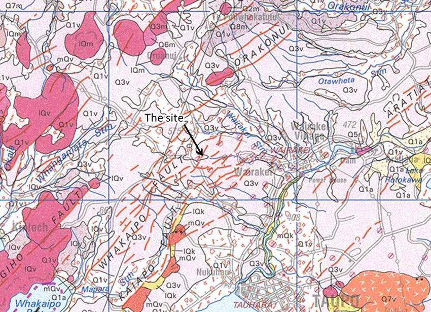
Te Mihi Expansion
Preliminary Site Investigation (Ground Contamination)

Contents
1.       Introduction ....................................................................................................................................... 4
1.1      Background ........................................................................................................................................................................... 4
1.2      Works description ................................................................................................................................................................. 5
1.3      Objectives and scope of this report ...................................................................................................................................... 5
1.4      Legislative requirements ....................................................................................................................................................... 5
2.       Site Description ................................................................................................................................ 6
2.1      Site identification ................................................................................................................................................................... 6
2.2      Site layout ............................................................................................................................................................................. 6
2.3      Environmental setting ........................................................................................................................................................... 8
3.       HAIL Assessment ............................................................................................................................. 9
3.1      Aerial photograph search ...................................................................................................................................................... 9
3.2      Council contamination records............................................................................................................................................ 10
3.2.1    Taupo District Council ......................................................................................................................................................... 10
3.2.2    Waikato Regional Council ................................................................................................................................................... 11
3.3      Other sources ..................................................................................................................................................................... 11
3.4      Potential for contamination ................................................................................................................................................. 12
4.       Preliminary Conceptual Site Model .............................................................................................. 14
5.       Development Implications ............................................................................................................. 15
6.       Conclusions .................................................................................................................................... 16

Appendices:
Appendix A – Relevant site information

Williamson Water & Land Advisory Limited                                                                                                                                                               iii
Te Mihi Expansion
Preliminary Site Investigation (Ground Contamination)
1. Introduction
Williamson Water & Land Advisory Ltd (WWLA) has been engaged by Contact Energy Ltd (Contact) to
undertake a contaminated land Preliminary Site Investigation (PSI) for the proposed expansion of the Te Mihi
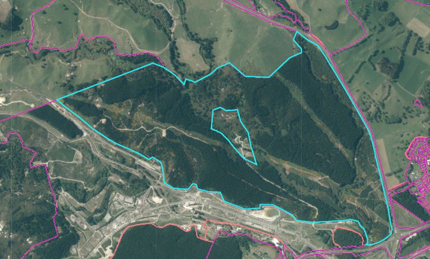
Power Station, Taupo (located at 136 Oruanui Road). The total area in which the Te Mihi power plant and
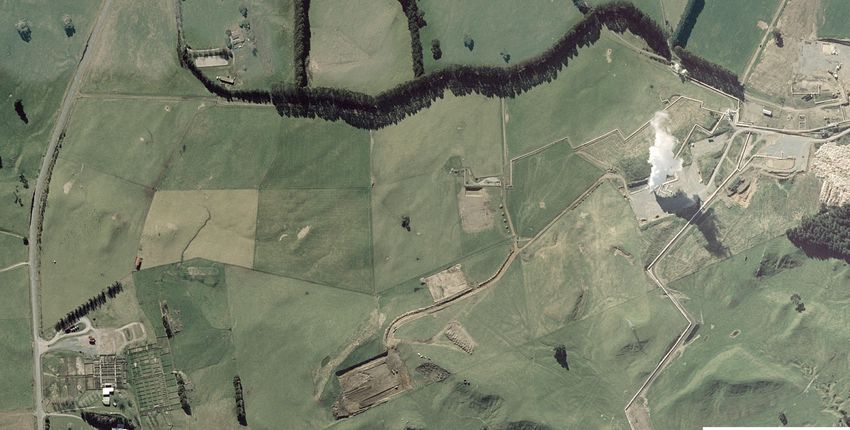
associated infrastructure is located is herein referred to as ‘the property’ (yellow boundary below) with the
expansion areas called ‘the site’ (orange shading below). The location of the property and site is shown in
Figure 1.
Figure 1. Site location (source: Google Earth via Contact). Land parcel outline in yellow (the property). Orange shading is
proposed expansion areas (the site).
1.1 Background
Contact owns and operates Te Mihi Power Station which was constructed in 2011-2013 and commissioned in
2014. The existing consent (Consent RM070304) authorises the installation and operation of the existing two
condensing steam turbine units, and also enables the construction and commissioning of a third condensing
steam turbine unit immediately adjacent to the existing units. The area for the third unit is called Site THI A and
was prepared as part of the construction of the existing power station.
However, a new application for a Land Use Consent is being sought under s.88 of the Resource Management
Act 1991 (the RMA) for the Stage 2 expansion because aspects of the proposed options for Stage 2 are beyond
the scope of what is authorised under Consent RM070304 in terms of location and/or the size and nature of the
electricity generation plant.
Consent is expected to be required under the NESCS1 due to the fact that the expansion is occurring on a site
that includes activities listed on the Ministry for the Environment (MfE) Hazardous Activities and Industries List
(Activity B4: Power station, switchyards and substations) and soil disturbance and land use change will likely
occur. However, large parts of the Te Mihi power station landholding are undeveloped thus this PSI explores
1 Resource Management National Environmental Standard for Assessing and Managing Contaminants in Soil to Protect Human Health (NESCS)
Regulation, 2011.
Williamson Water & Land Advisory Limited 4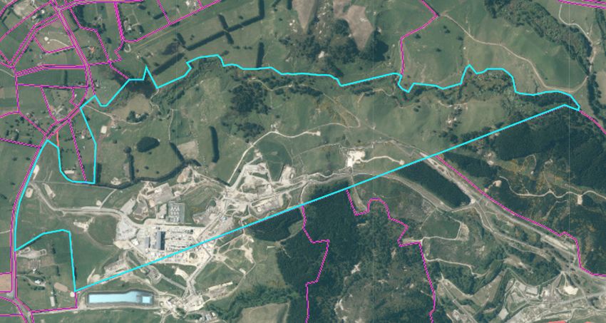
Te Mihi Expansion
Preliminary Site Investigation (Ground Contamination)

activities within the proposed expansion sites. Multiple options for the Stage 2 expansion are being considered
and are set out in Section 1.2. As these cover a large area and the final plans are not yet known, this PSI
considers what impact variations in the proposed layout within the development sites may have on consenting
and further investigation requirements (if any).

WWLA has prepared this document in accordance requirements for a PSI as set out in the NESCS and NESCS
User’s Guide (MfE, 2012). It includes an assessment against MfE’s HAIL.

1.2       Works description

There are two proposed locations for the expansion of the Te Mihi Power Station within Land Use Consent Area
– referred to as Site THI A (being the site of the consented third turbine unit adjacent to Stage 1 of the Te Mihi
Power Station) and Site THI B (being a much larger site to the east of the existing Te Mihi Power Station) as
shown on Figure 1.

The options for Stage 2 of the Te Mihi Power Station are:
• Option 1 (THI_1) – A single large steam turbine located within the existing consented footprint (Site THI A),
  with a gross output up to 180MW; or
• Option 2 (THI_2) – Two smaller steam turbines, one on the existing consented footprint (Site THI A) and
  one further southeast (Site THI B), with a combined gross output up to 180MW; or
• Option 3 (THI_3) – Organic Rankine Cycle Binary Plant, consisting of up to four units located on a footprint
  to the southeast of the existing Te Mihi Power Station (Site THI B), with a gross output up to 165MW.

1.3       Objectives and scope of this report

This investigation has been undertaken to identify the potential for contamination within the Te Mihi expansion
area, and the likely implications for site workers from a ground contamination perspective.

The scope of the investigation included:
1. Review of historical information sources including aerial photographs and discussions with Contact’s Te
   Mihi staff.
2. Assessment of the potential for contamination, based on historical land use and evaluation of that against
   the HAIL.
3. Development of a preliminary conceptual site model to identify potential ground contamination risks and
   mitigation requirements (if any) for the proposed expansion works.
4. Preparation of this report, documenting the findings of the investigation and the likely ground contamination-
   related consenting implications, requirement for further investigations as well as implications for the
   proposed expansion.

1.4       Legislative requirements

WWLA has prepared this investigation in general accordance with published industry best practice guidance,
including:
• Ministry for the Environment (MfE) Contaminated Land Management Guideline No. 1: Reporting on
  Contaminated Sites in New Zealand (Revised 2021); and
• NESCS Users Guide (2012).

This report has been prepared, reviewed and certified by Suitably Qualified Environmental Practitioners (SQEP)
as described in the NESCS Users Guide. Details confirming the expertise of WWLA’s SQEPs preparing and
certifying this report are available on request.

Williamson Water & Land Advisory Limited                                                                          5
Te Mihi Expansion
Preliminary Site Investigation (Ground Contamination)

2.         Site Description
2.1        Site identification

The property straddles two land parcels as described in Table 1 below. Note that the property does not include
the entire land parcels, only a portion of them.

Table 1.   Property identification.

 Address                 Owner                Legal description                 Certificate of title   Area

 136 Oruanui Road,       Contact Energy Ltd   Lot 3 DP 454472                   583496                 2,378,661 m2
 Taupo

 Poihipi Road, Taupo     Commissioner of      Deed of easement under s60 Land   778944                 3,248,800 m2
                         Crown Lands          Act 1948, 1/1, Section 4 Survey
                                              Office Plan 355555

2.2        Site layout

The sites are vacant land within the wider operational property. THI A is a constructed future unit pad, with a
largely concrete base and a small area of grass which will be the location of the future cooling tower. THI B is
farmland and forestry, with well pads located immediately west and the reinjection pump station to the
southwest. A site layout plan is shown in Figure 2.

Immediately north of THI A are the two existing geothermal units. These comprise a number of turbines,
generators, pumps, cooling towers, separators, scrubbers and other ancillary plant. North of the units is the
switchyard. Activities that are of interest from a contamination perspective include transformers, a diesel tank
and generator, and a sulphuric acid storage tank and associated pumps and dosing units for water treatment.
An oil-water separator is located adjacent to the diesel tank.

THI B surrounds well pads at its western extent but these are not a concern from a contamination perspective.
The reinjection pump station is separated from THI B by the Kiriohinaki Stream.

The wellfield for both Te Mihi and Wairakei Geothermal power plants extends to the northeast, through a valley
that leads to the Wairakei Geothermal Power Station. Poihipi Geothermal Power Station is located to the south
of Te Mihi.

Williamson Water & Land Advisory Limited                                                                              6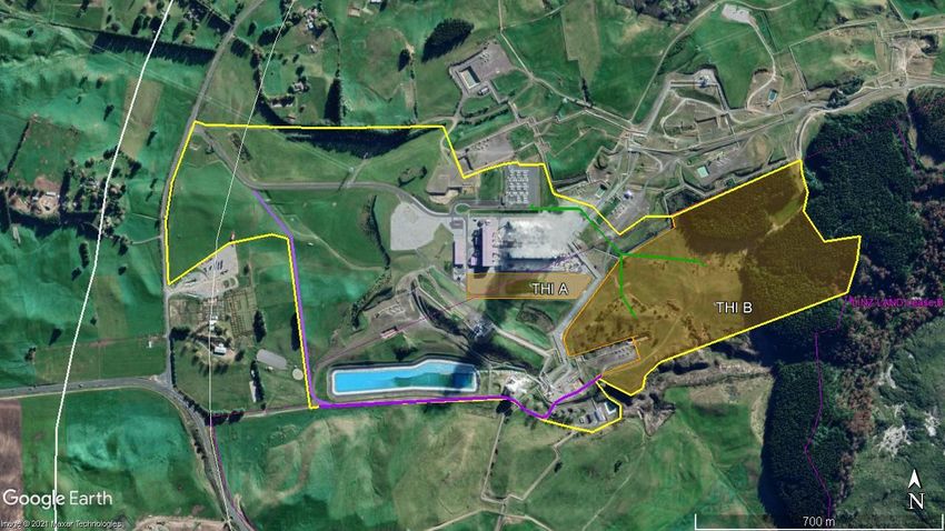
Map Title:
 Site Layout

Project:
PSI: Te Mihi Expansion

Client:

Contact Energy

Legend
           Site features

           Proposed development areas

Data Provenance
Aerial photograph sourced from Land Information
New Zealand

Layout & Project File
Site features

                                   Figure 2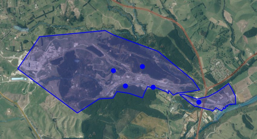
Te Mihi Expansion
Preliminary Site Investigation (Ground Contamination)

2.3        Environmental setting

Table 2:   Environmental setting

 Topography          The property has been subject to cut-to-fill earthworks for the construction of the Stage 1 power plant in 2011-2013
                     (refer Section 3.3). As a result, the area around THI A is largely flat. THI B has not been earthworked. The
                     ground slopes down toward the east in THI B.

 Historic features   The property was farmed for much of its known history prior to construction of the power station. Very little change
 and landforms       has occurred since the power station construction. Further site history is discussed in Section 3.

 Surrounding land    The property is predominantly surrounded by farmland. The steam field is located to the northeast of the property
 use                 and the Taupo saleyards are to the west. A forested area is located to the east and encroaches into THI B.

 Geology             The published geology (Figure 3) shows the site as being underlain by ignimbrite; primarily the non-welded
                     ignimbrite of the Oruanui Formation although with some recent Taupo Pumice Formation ignimbrite in the west.

                     Figure 3. Published geology of the site (Source: Leonard et al, 2010; GNS QMap 5).

 Hydrogeology        Shallow groundwater quality is influenced by upflows of geothermal water from deeper aquifers. As such there are
                     only limited groundwater users other than the power station in the immediate vicinity of the property. Most other
                     users are likely to be primarily for stock or irrigation water.

 Surface water       The Kiriohinaki Stream, ephemeral in the extent that traverses the property, flows from approximately the centre of
 bodies              the site toward the eastern boundary. A small lake called Alum Lake is located northeast of THI B, incorporating
                     around it a series of geothermal pools and springs.

 Significant         There are no significant ecosystems within close proximity to the property.
 ecosystems

Williamson Water & Land Advisory Limited                                                                                                    8
Te Mihi Expansion
Preliminary Site Investigation (Ground Contamination)

3.           HAIL Assessment
This HAIL Assessment includes review of historical land uses followed by evaluation of these against the MfE
HAIL, a list of activities with potential to cause ground contamination (soil and water). HAIL activities, if present,
may trigger regulatory requirements to ensure land is developed in a manner that presents effects of people and
discharges to the environment.

The history of the property was assessed through review of publicly available aerial photographs (Retrolens,
and Google Earth), Council contamination records and client-provided information.

3.1          Aerial photograph search

Historical aerial imagery findings are presented in Table 3 below. To summarise, the wider property was largely
undeveloped farmland until it was developed for the power station in 2011.

Table 3.     Historical aerial photograph review.

 Photograph          Activities                                                        Aerial image
 date (source)

 1967                The property is farmland with isolated mature trees. A large
 Retrolens           area of trees, roughly aligning with THI B, has recently been
                     felled. Farm tracks cross the property.
 (SN3005)

 1972                The property is still farmland but with three isolated
 Retrolens           geothermal structures within it. These appear to be early
 (SN3549 A/1)        test bores with ancillary infrastructure, possibly associated
                     with the Wairaeki Geothermal Field which was operational to
                     the east of the site. One of these structures lies within THI B
                     while the other two outside of the expansion areas.
                     The Taupo Saleyards have been constructed west of the
                     property.

 1982                The property is relatively unchanged compared to the 1972
 Retrolens           photograph.
 (SN5993 A/3)

Williamson Water & Land Advisory Limited                                                                             9
Te Mihi Expansion
Preliminary Site Investigation (Ground Contamination)
Photograph Activities Aerial image
date (source)
1996 The property is still being farmed. Further vegetation
Retrolens clearance has occurred on the eastern boundary.
(SN9584 D/11)
2011 Construction of the Te Mihi power station is underway.
Google Earth Multiple laydown areas are located around THI A and B, with
a large area of earthworks in the vicinity of THI A. Well pad
development is occurring to the northeast of the property.
2012-2013 Construction is still underway. Immediately south of THI A
Google Earth two water outflow pipes can be seen draining into the stream
located in the centre-east of the site.
2014-2020 Power station construction is complete. The area of THI A is
Google Earth a formed concreted area with a grassed stockpile in the
centre. Vegetation has returned to the eastern part of THI B
while the remainder has been returned to farmland.
The site remains unchanged through to 2020
3.2 Council contamination records
Refer to Appendix A for copies of Council communications.
3.2.1 Taupo District Council
Taupo District Council (TDC) contamination records were requested. Records held by TDC include a list of
contaminating activities either on the property or on related/ associated properties. We have excluded natural
features such as geothermal features and active faults which were also returned as part of the search. The
results returned only activities listed on ‘related properties’ with no activities indicated to be on the property
itself:
Williamson Water & Land Advisory Limited 10Te Mihi Expansion Preliminary Site Investigation (Ground Contamination) • Diesel tank. • Asbestos in a house. • Fertiliser storage bin. • Airstrip. • Dangerous Goods Storage (Wairakei Power Station). • Asbestos disposal on Poihipi Road. • Unknown dumping and stockpiling in 2011 of historic construction waste, potential further contamination beneath power pylons and around reinjection wells. 3.2.2 Waikato Regional Council Waikato Regional Council (WRC) records were also requested. WRC lists the site as contaminated due to the following activities: • Asbestos dumps (refer blue dots on Figure 4 below); • Power stations/ substations/ switchyards; and • Storage drums for fuel, chemicals and liquid waste, associated with Contact Energy and Huka Falls Jet In addition to the asbestos dumps specified by WRC, there is an additional asbestos dump (known as Beard’s Road Dump) located in approximately the location of the blue star on Figure 4. While not currently recorded on WRC’s register, it is known to Contact and has a management plan in place to ensure that it remains covered and is not accidently disturbed in future works. The Beard’s Road Dump is not within the development sites. The asbestos dumps are a significant distance from the site. Diesel storage is already known to occur immediately northwest of THI A and the entire property is considered a power station, although no contaminating activities actually occur on the development sites themselves. 3.3 Other sources Cut to fill plans for the site have been provided by Contact and reviewed (refer Appendix A). The plans show that the main construction laydown area during the construction phase was to the northwest of the geothermal units. Spoil disposal areas were all to the west of the units and power station infrastructure, between the units and Oruanui Road. A temporary silt pond was located south of THI A. In the vicinity of THI A the previous ground surface was cut down in the west and eastern extents of the THI A area, with fill placed in the central portion. Within the eastern cut area there was a former electrical pylon that was removed, with up to 10 m of soil then cut from that area. Up to 5 m of fill was placed in the central portion of THI A. There were no significant earthworks within THI B. Topsoil was to be stockpiled in specific bunds to the west of the THI A site and removed from the property following works completion. A search of the McConnell Dowell website (the lead contractors for the project) indicates that the works had a zero cut-to-fill balance. This means that it is highly unlikely fill was imported to site. Williamson Water & Land Advisory Limited 11
Te Mihi Expansion
Preliminary Site Investigation (Ground Contamination)

Figure 4: WRC records showing asbestos dumps as blue dots and stars. The sites are on the left-hand side of the blue shaded
polygon.

3.4         Potential for contamination

A description of all potentially contaminating (HAIL) activities identified for the property and an assessment of
their applicability is set out in Table 4. Overall, we consider that the potential for contamination at the two
proposed development sites is negligible. Aerial photographs show that there were no potentially contaminating
activities prior to the site development in 2011-2013. Activities since that time have been carried out according
to modern regulations and standards, meaning the potential for contamination to have arising from them and
migrated into the site areas is very low.

Table 4:    Potential HAIL activities within the development areas from previous and current land use.

 Land use                      Potential                 Possible extent of contamination                                       HAIL
                               contaminants                                                                                     Assessment

 Power station.                Metals,                   The majority of the potential for contamination within power           HAIL Activity
 Activity B4: Power            hydrocarbons              stations is associated with features such as diesel tanks for          A10 does
 stations, substations or                                generators, water treatment chemicals, transformers etc. These         not apply.
 switchyards                                             are assessed individually below. Given the modern nature of the
                                                         power station and the fact that it is geothermal, means the
                                                         potential for contamination is very limited to negligible across the
                                                         wider property. Within the two proposed development sites the
                                                         potential for contamination is negligible and no power station
                                                         features exist.

 Earthworks – placement        Wide variety              Cut and fill plans show that fill was only placed on a small portion   HAIL Activity
 of fill.                      depending on the          of THI A. Given there was a zero-balance for cut-to-fill activities,   does not
 HAIL Activity I: Accidental   nature of the fill, but   and that fill was engineered to a designed standard and therefore      apply.
 release of a contaminant      potentially metals,       will exclude topsoil (where contamination is most commonly
 in high enough                pesticides,               concentrated), it is highly unlikely that there is any contaminated
 concentrations to present     hydrocarbons,             fill in THI A.
 a risk to human health or     asbestos.                 No fill has been placed in THI B.
 the environment.

Williamson Water & Land Advisory Limited                                                                                                    12
Te Mihi Expansion
Preliminary Site Investigation (Ground Contamination)
Land use Potential Possible extent of contamination HAIL
contaminants Assessment
Diesel and sulphuric Hydrocarbons, lead, These tanks (and associated pumps, separators etc) are designed HAIL Activity
acid tanks. acid to a modern standard and are appropriately bunded with spill does not
HAIL Activity A17: Storage controls in place. The potential for contamination to enter the THI apply.
tanks or drums for fuel, A (or THI B) development areas from these sources is negligible.
chemicals, liquid waste
Asbestos dumps/ Asbestos There were no houses on the sites and WRC records indicate the HAIL Activity
asbestos on houses in a known asbestos dumps are to the northeast of THI B. does not
degraded state. Highly unlikely to have resulted in contamination on the site. apply.
HAIL Activity E1: Asbestos
products manufacture or
disposal.
Fertiliser storage. Nitrates No evidence that this was on site. The TDC records indicate it HAIL Activity
HAIL Activity A6: Fertiliser was on a ‘related site’. does not
bulk storage Highly unlikely to have resulted in contamination on the site. apply.
Airstrip. Metals, Not on the site. HAIL Activity
HAIL Activity F1: Airports hydrocarbons No potential for contamination to have migrated to site due to the does not
large distance from the site. apply.
Construction waste Wide variety Highly unlikely to have occurred on the site given the construction HAIL Activity
stockpiling. depending on the plans show that construction laydown and stockpiling areas are at does not
HAIL Activity I: Accidental nature of the waste, a distance from THI A and THI B. apply.
release of a contaminant but potentially
in high enough metals, pesticides,
concentrations to present hydrocarbons,
a risk to human health or asbestos.
the environment.
Power pylons. Metals The only noted power pylon was in THI A and that was removed HAIL Activity
HAIL Activity I: Accidental along with up to 10 m of underlying fill. It is highly unlikely that does not
release of a contaminant any contamination remains. There are no known pylons over THI apply.
in high enough B.
concentrations to present
a risk to human health or
the environment.
Williamson Water & Land Advisory Limited 13Te Mihi Expansion Preliminary Site Investigation (Ground Contamination) 4. Preliminary Conceptual Site Model A conceptual site model (CSM) indicates known and potential sources of contamination, routes of exposure (pathways), and the receptors that are affected by contaminants moving along those pathways. Receptors may be people or environmental. The site history assessment shows the only identified potential source of contamination is associated with the wider power station classification. However, when each of the activities that can cause contamination within a power station are assessed individually (i.e. diesel tanks, water treatment chemicals), the potential for contamination within the development areas is found to be negligible. As there is no source of contamination, there is no complete pathway to receptors for the Te Mihi Expansion works. Williamson Water & Land Advisory Limited 14
Te Mihi Expansion
Preliminary Site Investigation (Ground Contamination)

5.          Development Implications
We have reviewed implications for the site in terms of resource consents and future earthworks decision
making.

 Overview              The two development sites sit within wider properties that include an operational power station. The sites were
                       farmed until development of the power station commenced in 2011, with only small-scale test geothermal wells
                       in the vicinity until that time. THI B was not earthworked as part of the power station development and has
                       remained as pasture and forest throughout. THI A was subject to cut-to-fill operations and is now largely sealed
                       by a concrete pad. Although there are potentially contaminating activities in the vicinity of THI A, the potential for
                       these to have resulted in contamination at THI A is negligible due to the modern nature of the structures and the
                       type of operations concerned.

 Consenting            NESCS:
                       The NESCS sets out nationally consistent planning controls appropriate to district and city councils for assessing
                       potential human health effects related to contaminants in soil. The regulation applies to specific activities on land
                       (soil disturbance and removal, subdivision, bulk soil sampling and land use change) where an activity included
                       on the HAIL has occurred.
                       The NESCS applies to the wider property because HAIL activities have more likely than not occurred (power
                       station). However, in the proposed expansion areas (the site for the purposes of this PSI), HAIL activities have
                       not occurred and thus the NESCS does not apply.

                       Waikato Regional Plan:
                       The Waikato Regional Plan (WRP) covers disturbance of soils impacted by HAIL activities, but only if
                       remediation is occurring (starting from Rule 5.3.4.6). It is our experience that if no remediation is occurring,
                       WRC typically accepts that any contamination-related effects will be managed via the NESCS as implemented
                       by the relevant territorial authorities. No consent is required under the contamination rules of the WRP because
                       HAIL activities do not exist within the expansion areas and remediation is not occurring.

 Detailed site         Detailed investigations are not required as no potentially contaminating activities have occurred within the
 investigation/ soil   proposed upgrade areas of the power station landholding.
 sampling

 Earthworks            Earthworks can proceed with standard earthworks controls and procedures.

 Soil disposal         It is highly likely that surplus soil can be disposed of as cleanfill, although soil sampling may be required to
                       confirm this. Alternatively, soil could be kept on site, either under building platforms if geotechncially suitable, or
                       formed into landscaping or noise mitigation bunds.

 Health and safety     There are no contamination-specific health and safety requirements for workers carrying out the expansion
                       works. Good hygiene practices should be standard, including washing hands before eating/ drinking/ smoking,
                       and separation of works areas from break areas.

Williamson Water & Land Advisory Limited                                                                                                         15
Te Mihi Expansion Preliminary Site Investigation (Ground Contamination) 6. Conclusions This report has been prepared to comply with requirements of a preliminary site investigation (PSI) to support resource consent and inform future earthworks decision making. The key findings of this study are: • The sites and wider property were farmland until development of the Te Mihi power station commenced in 2011. Cut-to-fill plans show that during earthworks up to 10 m of material was cut from THI A with some engineered fill placed to create the desired levels. THI A has been largely sealed since that time. No earthworks or development has ever occurred on THI B. • Surrounding THI A and B are general power station infrastructure, including diesel and sulphuric acid storage near THI A. However, the potential for contamination from these source is considered negligible due to the modern and well-maintained nature of the tanks. Other potential sources of contamination identified in Council files are either at distance from the sites, or did not occur on the property at all. None of the identified HAIL activities in the surrounding area impact on alternative upgrade area positions. • A conceptual site model, documented to fulfil requirements for a PSI, confirms there is no risk to people or the environment as there is highly unlikely to be any contamination present. • Consent is not required under the NESCS because HAIL activities have not occurred within the proposed expansion areas (site). No consent is expected to be required under the contaminated land rules of the WRP. • Earthworks can proceed under standard earthworks controls and procedures. Health and safety procedures are also expected to be standard. Surplus soil is expected to be suitable for cleanfill disposal or can remain onsite. Williamson Water & Land Advisory Limited 16
Te Mihi Expansion
Preliminary Site Investigation (Ground Contamination)

Appendix A. Relevant site history documents

Williamson Water & Land Advisory Limited                17
1 2 3 4 5 6 7 8 9 10 11 12 13 14 15 16 17 18 19 20
A A
N
B B
153936-0-UZC-CV-PLN-103
C C
D D
E E
F F
G G
reproduced in whole or part for any purpose other than that for which it was supplied by PB. PB makes no representation, undertakes no duty and accepts no responsibility to any third party who may use or rely upon this document or the information.
Copyright in the drawings, information and data recorded in this document ("the information") is the property of PB. This document and the information are solely for the use of the authorised recipient and this document may not be used, copied or
H H
J J
K K
L L
M M
N N
© Parsons Brinckerhoff New Zealand Limited ("PB")
P P
SCALES AT A1 CLIENT PROJECT
7 03/04/12 ROAD LAYOUT AMENDED, CMH AB TO AC DESIGNED TE MIHI GEOTHERMAL POWER PROJECT
6 13/05/11 BUNDS ADDED CMH CG CG 0 10 20 40 60 PLANT UNIT SYSTEM DISCIPLINE FUNCTION SEQUENCE REV
DRAWN
5 29/04/11 SPOIL AREAS AND GENERAL EARTHWORKS AMENDED CMH CG CG JON Full Size 1:1000 ; Half Reduction 1:2000 DWG CHECK THIG 0 UZC CV PLN 103 7
SCALE (m) TITLE
4 01/04/11 HOLDS ADDED. RD01 AND STRUCTURAL FILL AREA AMENDED MH AB TO AB
DSN CHECK
CUT AND FILL CONTOUR PLAN
REV DATE DESCRIPTION DRAWN CHECK DESIGN VERIFY
DO NOT SCALE THIS DRAWING - VERIFY ALL DIMENSIONS APPROVED SHEET 2 OF 2
1 2 3 4 5 6 7 8 9 10 11 12 13 14 15 16 17 18 19 201 2 3 4 5 6 7 8 9 10 11 12 13 14 15 16 17 18 19 20
A A
N
B B
153936-0-UZC-CV-PLN-101
C C
D D
E E
F F
G G
reproduced in whole or part for any purpose other than that for which it was supplied by PB. PB makes no representation, undertakes no duty and accepts no responsibility to any third party who may use or rely upon this document or the information.
Copyright in the drawings, information and data recorded in this document ("the information") is the property of PB. This document and the information are solely for the use of the authorised recipient and this document may not be used, copied or
H H
J J
K K
L L
M M
N N
© Parsons Brinckerhoff New Zealand Limited ("PB")
P P
SCALES AT A1 CLIENT PROJECT
7 03/04/12 LAYOUT AMENDED . CMH AB TO AC DESIGNED TE MIHI GEOTHERMAL POWER PROJECT
6 13/05/11 EARTHWORKS AMENDED AND STAGING ADDED TLD CG CG AB 0 20 40 80 120 PLANT UNIT SYSTEM DISCIPLINE FUNCTION SEQUENCE REV
DRAWN
5 29/04/11 SPOIL AREAS AND GENERAL EARTHWORKS AMENDED CMH CG CG JON Full Size 1:2000 ; Half Reduction 1:4000
SCALE (m)
DWG CHECK THIG 0 UZC CV PLN 101 7
4 01/04/11 HOLDS 5 AND 6 AND SITE AREA ADDED MH AB TO AB TITLE
DSN CHECK
FINAL OVERALL PLAN AND STAGING
REV DATE DESCRIPTION DRAWN CHECK DESIGN VERIFY APPROVED
DO NOT SCALE THIS DRAWING - VERIFY ALL DIMENSIONS
1 2 3 4 5 6 7 8 9 10 11 12 13 14 15 16 17 18 19 207/22/2021 Williamson Water & Land Advisory Mail - FW: HAIL info for Wairakei Land
Wendi Williamson
FW: HAIL info for Wairakei Land
1 message
Todd Baldwin
To: Wendi Williamson
Cc: Lauren Windross
Wendi, email 1 of 2 for HAIL info from TDC.
From: Karen Murray
Sent: Thursday, 15 July 2021 1:47 pm
To: Todd Baldwin
Subject: RE: HAIL info for Wairakei Land
Hi Todd
See below
I have also attached a Consent decision for NES for 74 Oruanui Road
I can’t find the property for Karetoto road
Karen Murray Intermediate Development Adviser
Taupō District Council • 30 Tongariro Street, Taupō 3330
Private Bag 2005 • Taupō Mail Centre • Taupō 3352 • New Zealand
D +64 7 376 0638 T +64 7 376 0899 E kmurray@taupo.govt.nz
Follow us on Facebook and Twitter
www.taupo.govt.nz
From: Todd Baldwin
Sent: Thursday, 15 July 2021 1:21 PM
To: Karen Murray
Subject: HAIL info for Wairakei Land
CAUTION: This email originated from outside of the organisation. Do not click links, open attachments, or respond unless you recognise the sender and know the content is safe
Kia ora Karen,
Just wondered if you could help me with an info request please.
Could you please provide a list of known HAIL classifications or known contaminated sites or other related info on file at TDC for the following properties to assist us in HAIL requiremen
-76 Oruanui Road, Oruanui, Taupo. Lot 3 DP 454472.
https://mail.google.com/mail/u/0?ik=b03810166d&view=pt&search=all&permthid=thread-f%3A1705936840212009101%7Cmsg-f%3A170593684… 1/47/22/2021 Williamson Water & Land Advisory Mail - FW: HAIL info for Wairakei Land The red area is hot ground, the orange squiggly lines are fault avoidance areas and the blue squiggly lines are fault line awareness areas. -Karetoto Road, Wairakei, Taupo. Part Section 23 SO 43874. I cannot find anything for this legal description. Can you show on the map below the property you are referring to please https://mail.google.com/mail/u/0?ik=b03810166d&view=pt&search=all&permthid=thread-f%3A1705936840212009101%7Cmsg-f%3A170593684… 2/4
7/22/2021                                                     Williamson Water & Land Advisory Mail - FW: HAIL info for Wairakei Land

   These neighbouring properties are associated with the TeMihi and Wairakei Geothermal Power Stations.

   If you need any additional info please let me know.

   Thankyou.

   Nga mihi,

   Todd.

   Todd Baldwin
   Environmental Advisor
   Generation & Trading

   M: +64 22 535 0239 | E: todd.baldwin@contactenergy.co.nz

                               Private Bag 2001, Taupo 3352
                               Wairakei Power Station
                               Te Aro Road, Wairakei

                               Taupō, 3384, New Zealand
                               contact.co.nz

   ______________________________________________________________________
   CONTACT ENERGY GROUP NOTICE: The information contained in this transmission is confidential and may be legally privileged. It is intended for the named addressee only. If you a

https://mail.google.com/mail/u/0?ik=b03810166d&view=pt&search=all&permthid=thread-f%3A1705936840212009101%7Cmsg-f%3A170593684…                                                 3/4
7/22/2021 Williamson Water & Land Advisory Mail - FW: HAIL info for Wairakei Land
WARNING
This message may contain privileged and confidential information intended only for the use of the addressee named above. If you have received this message in error, please notify the Ta
This email (with or without any attachment) is not an official statement or formal document of the Taupo District Council unless otherwise stated and cannot necessarily be used in any leg
This e-mail has been scanned and cleared by MailMarshal http://www.marshalsoftware.com
______________________________________________________________________
This email has been scanned by the Symantec Email Security.cloud service.
For more information please visit http://www.symanteccloud.com
______________________________________________________________________
CONTACT ENERGY GROUP NOTICE: The information contained in this transmission is confidential and may be legally privileged. It is intended for the named addressee only. If you a
SD Discretionary (leasehold) (A2577670).pdf
2336K
https://mail.google.com/mail/u/0?ik=b03810166d&view=pt&search=all&permthid=thread-f%3A1705936840212009101%7Cmsg-f%3A170593684… 4/47/22/2021 Williamson Water & Land Advisory Mail - FW: HAIL info for Wairakei Land
Wendi Williamson
FW: HAIL info for Wairakei Land
1 message
Todd Baldwin
To: Wendi Williamson
Cc: Lauren Windross
Email 2 of 2 from TDC
From: Karen Murray
Sent: Thursday, 15 July 2021 2:16 pm
To: Todd Baldwin
Subject: RE: HAIL info for Wairakei Land
This is a massive property file held under the one address being 201 Karetoto Road, there are multiple businesses under this address – not just the power station, I will do my best. Loo
https://mail.google.com/mail/u/0?ik=b03810166d&view=pt&search=all&permthid=thread-f%3A1705936840212009101%7Cmsg-f%3A170593690… 1/67/22/2021 Williamson Water & Land Advisory Mail - FW: HAIL info for Wairakei Land Below shows the fault avoidance areas on the site. Karen Murray Intermediate Development Adviser Taupō District Council • 30 Tongariro Street, Taupō 3330 Private Bag 2005 • Taupō Mail Centre • Taupō 3352 • New Zealand D +64 7 376 0638 T +64 7 376 0899 E kmurray@taupo.govt.nz Follow us on Facebook and Twitter www.taupo.govt.nz From: Todd Baldwin Sent: Thursday, 15 July 2021 1:54 PM To: Karen Murray Subject: RE: HAIL info for Wairakei Land https://mail.google.com/mail/u/0?ik=b03810166d&view=pt&search=all&permthid=thread-f%3A1705936840212009101%7Cmsg-f%3A170593690… 2/6
7/22/2021                                                     Williamson Water & Land Advisory Mail - FW: HAIL info for Wairakei Land

   CAUTION: This email originated from outside of the organisation. Do not click links, open attachments, or respond unless you recognise the sender and know the content is safe

   Thanks for the quick reply Karen!

   That extra parcel Im interested in is this one next door to 76 just to the south. It covers a big area so the address wasn’t really listed.

   Apologies for my lack of skills to show this better.

   Does this help to identify it?

   Thanks.

   Todd.

   From: Karen Murray
   Sent: Thursday, 15 July 2021 1:47 pm
   To: Todd Baldwin
   Subject: RE: HAIL info for Wairakei Land

   Hi Todd

   See below

   I have also attached a Consent decision for NES for 74 Oruanui Road

   I can’t find the property for Karetoto road

   Karen Murray Intermediate Development Adviser

   Taupō District Council • 30 Tongariro Street, Taupō 3330

   Private Bag 2005 • Taupō Mail Centre • Taupō 3352 • New Zealand

   D +64 7 376 0638 T +64 7 376 0899 E kmurray@taupo.govt.nz

   Follow us on Facebook and Twitter

   www.taupo.govt.nz

   From: Todd Baldwin
   Sent: Thursday, 15 July 2021 1:21 PM
https://mail.google.com/mail/u/0?ik=b03810166d&view=pt&search=all&permthid=thread-f%3A1705936840212009101%7Cmsg-f%3A170593690…                                                 3/6
7/22/2021                                                  Williamson Water & Land Advisory Mail - FW: HAIL info for Wairakei Land
   To: Karen Murray
   Subject: HAIL info for Wairakei Land

   CAUTION: This email originated from outside of the organisation. Do not click links, open attachments, or respond unless you recognise the sender and know the content is safe

   Kia ora Karen,

   Just wondered if you could help me with an info request please.

   Could you please provide a list of known HAIL classifications or known contaminated sites or other related info on file at TDC for the following properties to assist us in HAIL requiremen

   -76 Oruanui Road, Oruanui, Taupo. Lot 3 DP 454472.

   The red area is hot ground, the orange squiggly lines are fault avoidance areas and the blue squiggly lines are fault line awareness areas.

   -Karetoto Road, Wairakei, Taupo. Part Section 23 SO 43874. I cannot find anything for this legal description. Can you show on the map below the property you are referring to please

https://mail.google.com/mail/u/0?ik=b03810166d&view=pt&search=all&permthid=thread-f%3A1705936840212009101%7Cmsg-f%3A170593690…                                                            4/6
7/22/2021                                                     Williamson Water & Land Advisory Mail - FW: HAIL info for Wairakei Land

   These neighbouring properties are associated with the TeMihi and Wairakei Geothermal Power Stations.

   If you need any additional info please let me know.

   Thankyou.

   Nga mihi,

   Todd.

   Todd Baldwin
   Environmental Advisor
   Generation & Trading

   M: +64 22 535 0239 | E: todd.baldwin@contactenergy.co.nz

                               Private Bag 2001, Taupo 3352
                               Wairakei Power Station
                               Te Aro Road, Wairakei

                               Taupō, 3384, New Zealand
                               contact.co.nz

   ______________________________________________________________________
   CONTACT ENERGY GROUP NOTICE: The information contained in this transmission is confidential and may be legally privileged. It is intended for the named addressee only. If you a

https://mail.google.com/mail/u/0?ik=b03810166d&view=pt&search=all&permthid=thread-f%3A1705936840212009101%7Cmsg-f%3A170593690…                                                 5/6
7/22/2021 Williamson Water & Land Advisory Mail - FW: HAIL info for Wairakei Land WARNING This message may contain privileged and confidential information intended only for the use of the addressee named above. If you have received this message in error, please notify the Ta This email (with or without any attachment) is not an official statement or formal document of the Taupo District Council unless otherwise stated and cannot necessarily be used in any leg This e-mail has been scanned and cleared by MailMarshal http://www.marshalsoftware.com ______________________________________________________________________ This email has been scanned by the Symantec Email Security.cloud service. For more information please visit http://www.symanteccloud.com ______________________________________________________________________ CONTACT ENERGY GROUP NOTICE: The information contained in this transmission is confidential and may be legally privileged. It is intended for the named addressee only. If you a WARNING This message may contain privileged and confidential information intended only for the use of the addressee named above. If you have received this message in error, please notify the Ta This email (with or without any attachment) is not an official statement or formal document of the Taupo District Council unless otherwise stated and cannot necessarily be used in any leg This e-mail has been scanned and cleared by MailMarshal http://www.marshalsoftware.com ______________________________________________________________________ This email has been scanned by the Symantec Email Security.cloud service. For more information please visit http://www.symanteccloud.com ______________________________________________________________________ CONTACT ENERGY GROUP NOTICE: The information contained in this transmission is confidential and may be legally privileged. It is intended for the named addressee only. If you a https://mail.google.com/mail/u/0?ik=b03810166d&view=pt&search=all&permthid=thread-f%3A1705936840212009101%7Cmsg-f%3A170593690… 6/6
7/26/2021         Williamson Water & Land Advisory Mail - FW: Land Use Information Register enquiry 136 Oruanui Road and 171 Karetoto Road, W…

                                                                                                     Wendi Williamson

 FW: Land Use Information Register enquiry 136 Oruanui Road and 171 Karetoto Road, Wairakei
 (REQ176134) LUI03375
 1 message

 Todd Baldwin                                                                              Mon, Jul 26, 2021 at 11:40 AM
 To: Lauren Windross
 Cc: Wendi Williamson

   Hi Lauren,

   Also received this from WRC.

   Cheers,

   Todd.

   From: Guy Sowry
   Sent: Friday, 23 July 2021 3:36 pm
   To: Todd Baldwin
   Subject: Land Use Information Register enquiry 136 Oruanui Road and 171 Karetoto Road, Wairakei (REQ176134) LUI03375

   Dear Todd

   Thank you for your enquiry regarding information the Waikato Regional Council may hold relating to potential contamination at the property indicated
   below:

   136 Oruanui Road, Wairakei: Lot 3 DP 454472 (VRN 07383/123/05)

   171 Karetoto Road, Wairakei: SEC 23 SO 438784

https://mail.google.com/mail/u/0?ik=b03810166d&view=pt&search=all&permthid=thread-f%3A1706302069310756322%7Cmsg-f%3A170630206…                            1/4
7/26/2021 Williamson Water & Land Advisory Mail - FW: Land Use Information Register enquiry 136 Oruanui Road and 171 Karetoto Road, W… Background: The Waikato Regional Council maintains a register of properties known to be contaminated on the basis of chemical measurements, or potentially contaminated on the basis of past land use. This register (called the Land Use Information Register) is still under development and should not be regarded as comprehensive. The 'potentially contaminated' category is gradually being compiled with reference to past or present land uses that have a greater than average chance of causing contamination, as outlined in the Ministry for the Environment's Hazardous Activities and Industries List (HAIL): http://www.mfe.govt.nz/sites/default/files/hazards/contaminated-land/is-land-contaminated/hazardous-activities-industries-list.pdf This property: I can confirm that this property does appear on the Land Use Information Register, as indicated by the area shaded blue on the map below. The area shaded blue above appears on the Land Use Information Register as LUI03375 with a classification of ‘Contaminated’ due to current land use for HAIL activity ‘E1. Asbestos products manufacture, disposal or deteriorated buildings’ associated with known asbestos dumps at this site (as indicated by the blue dots). The site is also listed for HAIL activities ‘B4 Power stations, substations or switchyards’ and ‘A17 Storage or drums for fuel, chemicals or liquid waste’ associated with Contact Energy Limited and Hula Jet. https://mail.google.com/mail/u/0?ik=b03810166d&view=pt&search=all&permthid=thread-f%3A1706302069310756322%7Cmsg-f%3A170630206… 2/4
7/26/2021 Williamson Water & Land Advisory Mail - FW: Land Use Information Register enquiry 136 Oruanui Road and 171 Karetoto Road, W…
This site is listed on the register for information only as we do not hold any contaminated land investigations completed in accordance with Ministry for
the Environment Guidelines.
District Councils: Our records are not integrated with those of territorial authorities, so it would also be worth contacting the Taupo District Council to
complete your audit of Council records if you have not already done so. In general, information about known contaminated land will be included on a
property LIM produced by the territorial authority.
Rural Land Considerations: Examples of sites that are "more likely than not" to have soil contamination (HAIL sites) include timber treatment
activities, service stations and/or petroleum storage, panel beaters, spray painters, etc. Whilst pastoral farming is not included on this list, typical
farming activities of horticulture, sheep dipping, chemical storage, petroleum storage and workshops are; but are more difficult to identify and may not
be as well represented on the Land Use Information Register. Therefore, individuals interested in pastoral land may be interested in completing further
investigations in accordance with Ministry for the Environment Guidelines prior to land purchase and/or development.
Additional Information: Please note that:
· Significant use of lead-based paint on buildings can, in some cases, pose a contamination risk; the use of lead-based paint is not recorded on
the Land Use Information Register.
· Buildings in deteriorated or derelict condition which contain asbestos can result in asbestos fibres in soil; the use of asbestos in building
materials is not recorded on the Land Use Information Register.
· The long term, frequent use of superphosphate fertilisers can potentially result in elevated levels of cadmium in soil; the use of superphosphate
fertiliser is not recorded on the Land Use Information Register.
· We are not currently resourced to fully incorporate historic aerial photographs in our region-wide assessment of HAIL activities. A significant
proportion of the Crown historical aerial image archive for the Waikato region is available to view free of charge at http://retrolens.nz/. We
recommend this resource is consulted for any HAIL assessment.
· Due to the large volume of enquiries being received, we may not be able to respond to your enquiry as quickly as previously. We are resourced
to meet 20 day response times as per LGOIMA, but endeavour to respond more quickly when workload permits. If your enquiry is urgent, please
note this first in your enquiry and we will do our best to assist.
Please feel free to contact me if you have any further queries on this matter. For any new enquiries or requests for information please continue to use
the Request for Service form for ‘Contaminated Land/HAIL.’
Regards,
Guy Sowry | CONTRACTOR | Land and Soil, Science and Strategy
WAIKATO REGIONAL COUNCIL | Te Kaunihera ā Rohe o Waikato
P: +6478592839
F: facebook.com/waikatoregion
Private Bag 3038, Waikato Mail Centre, Hamilton, 3240
**********************************************************************
This email message and any attached files may contain confidential information, and may be subject to legal professional privilege. If you have
received this message in error, please notify us immediately and destroy the original message. Any views expressed in this message are those of the
individual sender and may not necessarily reflect the views of Waikato Regional Council. Waikato Regional Council makes reasonable efforts to ensure
that its email has been scanned and is free of viruses, however can make no warranty that this email or any attachments to it are free from viruses.
**********************************************************************
______________________________________________________________________
This email has been scanned by the Symantec Email Security.cloud service.
For more information please visit http://www.symanteccloud.com
https://mail.google.com/mail/u/0?ik=b03810166d&view=pt&search=all&permthid=thread-f%3A1706302069310756322%7Cmsg-f%3A170630206… 3/47/26/2021 Williamson Water & Land Advisory Mail - FW: Land Use Information Register enquiry 136 Oruanui Road and 171 Karetoto Road, W… ______________________________________________________________________ CONTACT ENERGY GROUP NOTICE: The information contained in this transmission is confidential and may be legally privileged. It is intended for the named addressee only. If you are not the named addressee you may not copy, distribute or take any action in reliance upon this transmission. https://mail.google.com/mail/u/0?ik=b03810166d&view=pt&search=all&permthid=thread-f%3A1706302069310756322%7Cmsg-f%3A170630206… 4/4
You can also read