Land cover-adjusted index for the former Aral Sea using Landsat images
←
→
Page content transcription
If your browser does not render page correctly, please read the page content below
E3S Web of Conferences 227, 02005 (2021) https://doi.org/10.1051/e3sconf/202122702005
GI 2021

 Land cover-adjusted index for the former Aral
 Sea using Landsat images
 Ilhomjon Aslanov1∗, Sayidjakhon Khasanov1,3, Yakhshimurad Khudaybergenov2, Michael
 Groll4, Christian Opp Ch4, F. Li3, and Ramirez Del-Valle E5
 1
 Tashkent Institute of Irrigation and Agricultural Mechanization Engineers, Tashkent, Uzbekistan
 2
 Department of Geodesy, cartography and natural resources, Karakalpak State University, Nukus,
 Karakalpakstan, Uzbekistan
 3
 Institute of Geographical Sciences and Natural Resources Research, Chinese Academy of Sciences,
 Beijing, China
 4
 Faculty of Geography, Philipps-Universität Marburg, Germany
 5
 Institute of Biology, National Autonomous University of Mexico, Mexico

 Abstract. The Aral Sea was the fourth largest inland lake on the globe
 until 1960, with a surface area of about 68,000 km2. Mainly, the huge
 irrigation projects in many parts of its transboundary catchment were
 responsible for the catastrophic desiccation and ecological crises of the
 Aral Sea after second part of 20th century. Ecological crisis surrounding
 the Aral Sea (lake) regions is one of the critical environmental problems of
 Central Asia. As a result, monitoring of desertification processes and
 determining the aerosol concentration in the atmosphere are highly relevant
 for any attempts to mitigate environmental changes in the Aral Sea basin.
 Remote sensing is the most appropriate method for studying desertification
 and dust storms as it easily covers large areas with a high spatial and
 temporal resolution. Satellite images provide detailed multispectral
 information about the earth’s surface features, which proves invaluable for
 the characterization of vegetation, soil, water, and landforms at different
 scales. Vegetation cover, biomass, and soil properties were analyzed with
 remote sensing methods (NDVI, SDVI). It is emphasized that vegetation
 indices have little sensitivity at low leaf area which is common to all desert
 ecosystems.
 Keywords: Aral Sea, Water shrinkage, Land-Cover, Remote Sensing,
 GIS, Central Asia, NDVI

 1 Introduction
 The immediate cause of the lake water disappearance of the Aral Sea is the fact that its
 two major rivers, the Amu Darya and Syr Darya, only contributed an average of 5 km³ of
 water to the lake's annual water balance instead of the former quantity of 56 km³. Besides
 that, in many years, the river water did not even reach the lake at all [12, 47]. Since there
 was no sufficient water to ensure the lake water balance, the evaporation rate from shallow

 ∗
 Corresponding Author: ilhomaslanov@tiiame.uz, ilhomaslanov@gmail.com

© The Authors, published by EDP Sciences. This is an open access article distributed under the terms of the Creative Commons
Attribution License 4.0 (http://creativecommons.org/licenses/by/4.0/).
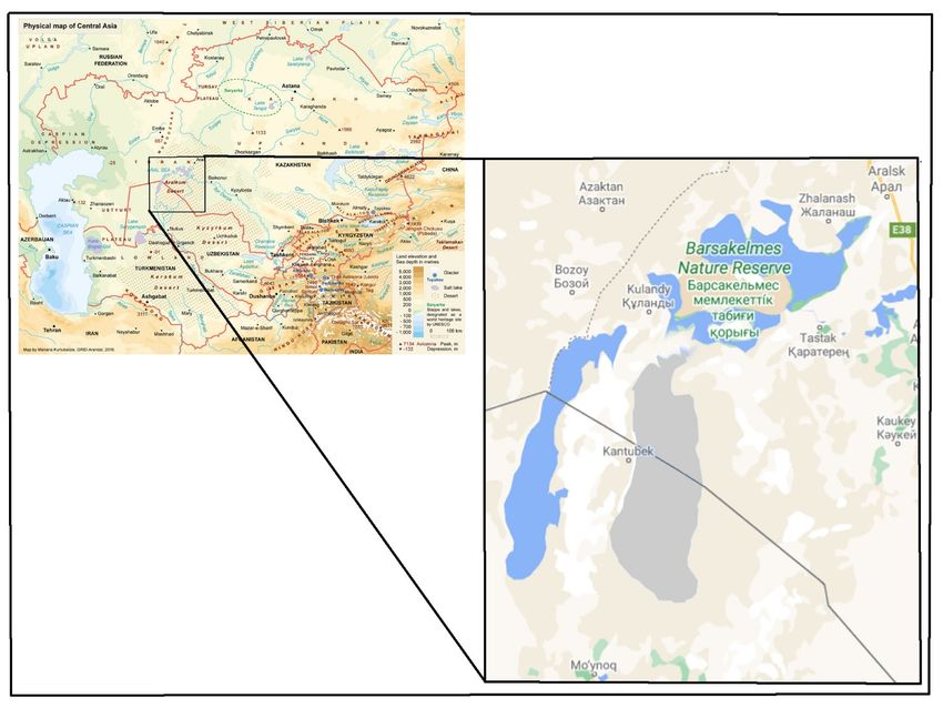
E3S Web of Conferences 227, 02005 (2021) https://doi.org/10.1051/e3sconf/202122702005
GI 2021

 depths of the lake has been dramatically increasing, thus urging to actively develop
 potential remediate measures to combat with this human-induced environmental issue [30,
 33, 18, 14]. Detailed analysis of land cover using remote sensing data in large area provides
 a complete profile for better analyzis and mapping. Instead the lake surface a new desert
 has been covering the Aral Sea region during the last six decades. Sand and dust storms
 often do have its source area from this bare sandy area of the Aral Sea accelerating
 desertification processes [45, 3]. They are often reflecting an early warning about the
 ongoing local and regional environmental changes around the Aral Sea [46, 5]. Once they
 progress from slight to serious and severe categories they contribute to the spread of
 desertification through the transport and deposition of sediments that can destroy local
 ecosystem and infrastructure, and render areas uninhabitable [43, 30]. During sand
 transportation, airborne dust is involved in many physicochemical processes of the
 atmosphere, hydrosphere, and geosphere. Atmospheric sand deposition composes Aeolian
 mineral particles which strongly contribute to the composition of the sediments, both on the
 continents and in oceans worldwide [11, 39]. Conducted an in-depth and systematic
 analysis of long-term space and time variations in of both area and water volume of the
 Aral Sea, and their potential drivers, which was lacking prior to these experiments[47, 42,
 28, 9, 26]. Firstly, they extracted the lake surface area of the Aral Sea using one of the
 Remote Sensing (RS) indices, Normalized Difference Vegetation Index (NDVI), based on
 the dataset captured by MODIS during 2000-2018. This extraction enabled to quantify and
 distinguish the inter-annual variations of lake surface area and water volume of the Aral
 Sea during 1960–2018 based on long-term hydrological data generated by the MODIS
 sensor. The results of these experiments revealed that from 1960 to 2018 the area of the
 Aral Sea shrank dramatically and the average water shrinkage rate per annum accounted for
 around 1,000 km2. They claim that this shrinkage rate has decelerated over recent years.
 Besides that, during the experiments, marginal expansion of the Aral Sea lake surface area
 was observed. As these scientists assert that in 1986, the Aral Sea split into two lakes. Since
 then, these two lakes have encountered opposing trends: the much bigger South Aral Sea
 located in Uzbekistan has shrunk dramatically despite having some trend oscillations, while
 the North Aral Sea located in Kazakhstan has enlarged obscurely [1].
 Considering the above mentioned results, this paper aims to provide an improved
 insight to spatio-temporal land-cover change, aligning with water shrinkage, from 1960 in
 the Aral Sea was change water balance and start shrinking but however in the last two
 decades and to determine a water shrinkage rate per annum based on Landsat sensor.
 Besides that, as an objective of this paper, once a water shrinkage rate has been ascertained,
 performing a simplified correlation analysis between land-cover change of the Aral Sea and
 climate data is contemplated. Based on the expected results some conclusions should be
 given regarding the water shrinkage effects both on the land use changes and on the
 formation of sand and dust storms.

 2 Study area
 Central Asia is the largest landlocked region in the world. The majority part of its
 landscapes is desert, semi-desert, dry steppes, and high mountains [32]. Due to the fact that
 the Aral Sea region became after the desiccation disaster of the Aral Sea a very vulnerable
 ecological zone, where desertification processes have been accelerated during the last four -
 six decades [24], this study site was selected for further investigations. The Aral Sea is
 located in the central part of Turan lowland in Central Asia and surrounded by several
 deserts, and is sandwiched between two deserts, the Karakum and the Kyzylkum. [41, 15]
 (Fig 1). The Aral Sea is nowadays considered as a salty lake bestriding the Uzbek-Kazakh
 border, covering an area of approximately 68,478 km2 with a total volume of 1,064 km3, a

 2
E3S Web of Conferences 227, 02005 (2021) https://doi.org/10.1051/e3sconf/202122702005
GI 2021

 maximum depth of 69 m, an average depth of 16 m and a shoreline stretching for more than
 4,430 km in 1960 [28].
 Since the Aral Sea is situated in a dry region with high summer temperatures, where the
 average annual rainfall is below 250 mm, there is immense evaporation. However, over the
 past eight decades, annual precipitation in the Aral Sea region has increased, with winter
 suffering the largest growth trend with 0.7 mm [47]. The Aral Sea region has a distinct
 continental climate that features exceptionally improved solar radiation and extremely low
 humidity, negligible rainfall, uncertain time of precipitation, and huge differences between
 seasonal and annual average temperatures. In the lower locations of this region, average air
 temperatures in July are around 30 °C while the highest air temperature often reaches 45 °C
 and 50 °C, respectively; Average air temperatures in the winter season range from −8 °C to
 0 °C, with the lowest temperature hovering around −38 °C [4].

 Fig.1. Location of the Aral Sea (Source: GRID-Arendal)

 3 Methods
 Application of remote sensing tools and techniques are important to instantly assess the
 dynamics of land-cover change at the wider spatial resolution, rather than spending more
 time on the in-situ research. These tools have a great potential to monitor and evaluate
 drought processes and water shrinkage including the Aral Sea disaster [17, 41] first started
 to locate, assess and monitor the land-cover in drylands with geo-information systems
 (GIS) and RS techniques. They claimed that GIS and RS-based data provide a permanent
 record of the land-cover changing rate in such a format that records measurable changes.
 [17] considered that the RS approach towards the land cover analysis plays an important
 and key role as one of the major sources of state-of-the-art and physically-based
 information, whereas GIS provides the toolbox that improves the ability of data integration,
 data analysis and data extraction from the source. According to [2, 7, 25, 36] it is possible
 to understand the desertification rate as a result of land-cover changes. The amounts of
 land-cover changes can be assessed by using RS indices like NDVI and Soil-Adjusted
 Vegetation Index (SAVI). These indices might function as a basis for an early warning of

 3
E3S Web of Conferences 227, 02005 (2021) https://doi.org/10.1051/e3sconf/202122702005
GI 2021

 desertification. NDVI and SAVI, calculated using satellite images, have revealed the
 capability of RS for systematic, reliable and spatially extensive monitoring of drought after
 water shrinkage [7, 29, 37, 38]. Recent studies have also shown that with the help of the
 integrated use of GIS and RS analyses of both temporal and spatial dynamics of land-cover
 changes caused by drying surface water bodies become possible, [46] analyzing potential
 changes occurring among land cover features and develop the baseline maps of
 desertification or land-cover [6, 16, 44]. Concerning these studies, RS implies either
 satellite images or aerial photography to perform a trend analysis for future scenarios and
 create trend maps showing the possible changes in land cover condition over a certain
 period [27].

 4 Data
 The Physical map of Central Asia from 1960 was taken as a source to extract the former
 extent of the Aral Sea, which was 68,000 km2, to gain a deep insight how land-cover of this
 region has spatially and temporally changed in combination with water shrinkage.
 However, the base year of the present analysis is set in 1999, because the nationwide
 assessment of the Aral Sea shrinkage effects was commenced, and the analysis was
 conducted till 2019. This Physical Map was digitized in order to extract the borders of
 extent of the Aral Sea for further analysis.
 For secondary data satellite images taken especially in the end of each year (1999, 2009,
 and 2019) were downloaded from the open source databases Earth Explorer and Glovis
 (www.earthexplorer.usgs.gov; www.glovis.usgs.gov). This period was used to learn similar
 patterns at the end of the years. For this reason, the last cloud-free days of December are
 highly appropriate to observe the dynamics of land-cover in the Aral Sea region. Regarding
 the sensors of satellite images, Landsat TM 5, Landsat ETM+ 7 and Landsat 8 OLI (for
 further information on Landsat sensors, see CRISP) were used. The temporal resolution of
 the selected sensors is 16 days, whereas, the spatial resolution of images is 30 meters,
 which means one pixel of the image covers 30 m x 30 m of land surface.

 4.1. Data processing and analysis
 The analysis of land-cover in the shrinking Aral Sea region required several steps to
 interpret the results. Firstly, initial preprocessing steps and operations on satellite images
 (e.g. atmospheric and geometric corrections, outlier removal and mosaicking) were
 undertaken which directly improved the quality and the accuracy of the remote sensing
 maps [38, 25, 23, 21, 8]. Then the further analysis was conducted by using ArcGIS and
 Erdas Imagine software packages. Then, a GIS tool called “Resample” was used in order to
 convert the actual pixel size of the satellite images to 150 meters x 150 meters to expedite
 analyzing processes, return an enhanced visualization, and reduce the size of the remote
 sensing images to ensure proper data storage. Afterwards, the Normalized Difference
 Vegetation Index (NDVI) was applied to detect the canopy cover from the satellite images.
 The NDVI ranges from -1 to 1 and assesses whether the target being analyzed contains
 photosynthetically active vegetation or not by using Equation 1 [2]:

 −
 = (1)
 +

 4
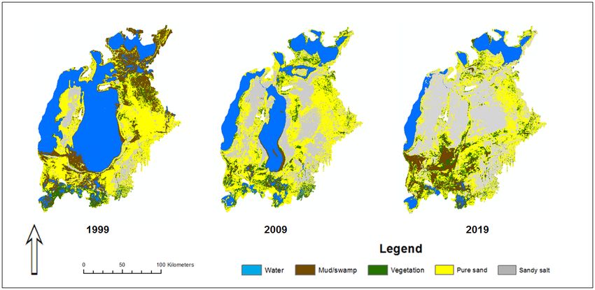
E3S Web of Conferences 227, 02005 (2021) https://doi.org/10.1051/e3sconf/202122702005
GI 2021

 Where: NIR is the Near InfraRed band of Landsat sensor (band 4 for Landsat TM 5 and
 Landsat ETM+ 7; band 5 for Landsat 8 OLI); and RED is the red band of Landsat sensor
 (band 3 for Landsat TM 5 and Landsat ETM+ 7; band 4 for Landsat 8 OLI).

 Once the NDVI was calculated, vegetation cover above 0.3 NDVI was removed from
 each satellite image [22, 35] in order to improve the accuracy of the Soil-Adjusted
 Vegetation Index (SAVI) values ranging from -1.5 to 1.5. The SAVI enables the sufficient
 description of the soil-vegetation system and soil type classification which is essential for
 estimating the consequences of land-cover change by using Equation 2 [19, 2].

 −
 = × (1 + ) (2)
 + +

 Where: L is a soil adjustment factor (according to Huete (1988), L = 0.5)
 After all, the NDVI and SAVI-based maps were stacked to create final land-cover maps.
 When a potential RS index, SAVI, was found to describe the soil system and reflection, the
 footprint (to verify whether sandy soil or vegetation cover is dominantly occupying the Aral
 Sea region) of water shrinkage in the Aral Sea was evaluated for all years (1999-2019).
 When outcome maps were created for all years, the dynamics of the salt-sand-canopy
 cover close to the study area were showing whether the actual area of the lake was
 preoccupied by canopy or bare (salty-)sandy soil. As far as the actuality was identified, the
 above-mentioned step-by-step methods were enough to tell the average annual water
 shrinkage rate of the Aral Sea.
 A simple correlation analysis was performed using R software to identify how water
 shrinkage correlated with wind speed and air temperature. Data on wind speed and air
 temperature were recorded in two different meteo-stations, ‘Aralskoe More’ and ‘Uyaly’,
 located close to the Aral Sea and were retrieved from an open source “NASA Earth
 Observatory”. Additionally, for statistically proving the correlation between wind speed
 and water shrinkage, a simple linear regression analysis was undertaken to check whether
 the p-values of all variables were statistical significant (p > 0.05 – statistically insignificant;
 p < 0.05 – statistically significant).

 5 Results
 As a consequence of the drying up of the Aral Sea for the last 20 years, the landscape of
 the dried-up part of the Aral Sea was completely transformed, thus a new born desert –
 Aral-Kum desert appeared (Fig 2). New map of Aral-Kum illustrates the land-cover map of
 the study area for the last two decades.
 According to the land-cover maps (Fig. 2) created by the combination of NDVI and
 SAVI indices, already visually, the lake surface area of the Aral Sea has experienced a
 critical shrinkage. On the other hand, aligning with sandy areas, salty sand areas have
 dramatically extended to the eastern side and, over decades, due to natural phenomena,
 salty sand has also migrated from the east to the central part. It is interesting to note that the
 of mud and vegetation areas were still not preoccupied by hazardous sandy or salty layers.
 Thereafter, in order to derive quantitative values on the distribution of each land-cover
 class, the “Reclassify” operation was performed in ArcGIS software to transfer the
 qualitative data into quantitative. The result of this operation is displayed in (Fig. 3).

 5
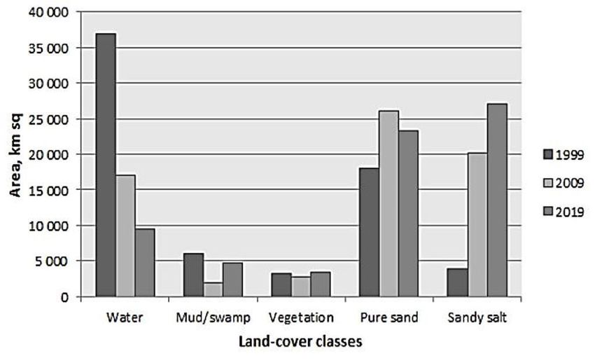
E3S Web of Conferences 227, 02005 (2021) https://doi.org/10.1051/e3sconf/202122702005
GI 2021

 Fig. 2. Dynamics of land-cover change in the Aral Sea from 1999 to 2019.

 Fig. 3. Breakdown of land cover classes from 1999 to 2019
 As can be seen in Fig. 3, there were evidentially upward trends for the extension of the
 actual sandy salt and sandy areas, despite experiencing fluctuations. Sandy areas occupied
 approximately 18,000 km2 in 1999, whereas sandy salt areas accounted for below 5,000
 km2. Both land-cover classes have invaded another roughly 5,000 km2 and 20,000 km2 of
 the Aral Sea territory, respectively, by the end of 2019. The lake area sharply has been
 shrunk by approximately 25,000 km2 over 20 years. However, the other two land-cover
 classes, mud and vegetation cover, almost remained stable in the entire period of the
 analysis, where vegetation cover in the Aral Sea region was rather certain than muddy area.
 Referring to Figure 3 it is possible to calculate the average shrinkage value. Compiling
 all of the enlarged and decreased land-cover areas together, the annual water shrinkage rate
 per annum of 1,372.65 km2 was determined.
 After having calculated the shrinkage rate, a simple correlation analysis was carried out
 for water and all land-cover classes to understand how the changes in each class
 interconnected each other (Table 1).

 6
E3S Web of Conferences 227, 02005 (2021) https://doi.org/10.1051/e3sconf/202122702005
GI 2021

 Table 1. Correlation analysis of land cover classes

 Water Mud/Swamp Vegetation Pure sand Sandy salt
 Water 1 0.66 0.59 -0.99 -0.99
 Mud/Swamp 0.66 1 0.74 -0.91 -0.65
 Vegetation 0.59 0.74 1 -0.46 0.01
 Pure sand -0.99 -0.91 -0.46 1 0.80
 Sandy salt -0.99 -0.65 0.01 0.80 1

 According to the interesting aspect of the correlation table (Tab. 1), water was
 positively correlated with mud (0.66) and vegetation (0.59). More specifically this means,
 when lake surface area increases, mud and vegetation will stay proportional as a response to
 the increase of lake surface area. However, the lake surface area was totally and negatively
 correlated with pure sand (-0.99) and sandy salt (-0.99) causing an increase when lake area
 shrinks.
 For the continuation of the statistical analysis, ANOVA was applied for water areas to
 check its dynamics and the shrinkage whether it was significant or not. As a result, R2 was
 equal to 0.83 in three observations, whereas F and F critical were 3.532 and 3.478,
 respectively, according to the results of ANOVA (Table 2). Last but not least, the p-value
 was calculated to test against statistical significance of water shrinkage rate in relation with
 other land-cover classes. The p-value here is the main character of the table, indicating if
 the relation between variables is statistically significant (p > 0.05 – insignificant; p < 0.05 –
 significant).
 Table 2. ANOVA output
 Source of SS* df** MS*** F p-value F critical
 variation ratio
 Between groups 1.04E+09 4 2.59E+08 3.532 0.0028 3.478
 Within groups 7.34E+08 10 7.34E+07
 Total 1.77E+09 14
 *-sum-of-square – sum of the square of variation;
 **-degree of freedom – the maximum number of logically independent values (in our case, the water
 shrinkage rate of the Aral Sea) that have the freedom to vary;
 ***-mean squares – an estimate of population variance;

 Once the correlation between classes was revealed, the correlation between such land-
 cover classes (lake, pure sand and sandy salt) and climate factors was founded to determine
 the role of wind speed and air temperature for water shrinkage and for the formation of
 sand and dust storms.
 As emphasized in the methodology, climate data like wind speed and average seasonal
 air temperature in summer were additionally included in the correlation analysis for such
 land-cover classes (Table 3).
 Table 3. Correlation coefficients between climate factors and land-cover classes

 Pure
 Water Sandy salt
 sand
 ‘Aralskoe More’ avg. T, oC -0.91 0.52 0.93
 meteostation WS, m/s -0.86 0.99 0.84
 ‘Uyaly’ avg. T, oC -0.94 0.96 0.93
 meteostation WS, m/s -0.98 0.90 0.98

 7
E3S Web of Conferences 227, 02005 (2021) https://doi.org/10.1051/e3sconf/202122702005
GI 2021

 According to the data presented in Table 3, in general, there is a huge impact of climate
 data on water shrinkage and these two climate factors boost the actual evaporation rate.
 Herein, a decrease of lake area in the Aral Sea region was exceptionally and significantly
 correlated with wind speed and seasonal average air temperature registered in two different
 meteostations close to the study area. As the main primary or natural drivers of ecosystem
 destruction and dust and sand storms formation in the region, these climate factors were
 seriously correlated with pure sand and sandy salt which can migrate through wind due to
 their minor particle size.
 Referring to the correlation tables, it is assumed that the impact of climate factors was
 mainly detected and significantly relevant to the change in lake surface area. While an
 increase in air temperature leads to an adverse change in lake areas as a result of
 evaporation, it can be assumed that the current policies for regional climate action need to
 be sustainably amended.

 6 Conclusions
 This paper shows that as a result of the drying up of the Aral Sea over the last 20 years,
 a new salty desert, namely Aral-Kum desert, has formed on an extensive area in its dried
 part. As the Aral Sea shrinking water is replaced by newly formed salty desert, known as
 Aral-Kum, the potential for the mobilization of salts and heavy metals included in the
 exposed lake sediments raises considerable concerns for the southern Aral Sea region,
 which is mainly affected by dust from the Aral-Kum. Most of the Aral-Kum sediments
 show negligible heavy metal concentrations, indicating that the Aral Kum might not be the
 major source of these pollutants, but that local geological and anthropogenic factors are
 prevalent. The high variability of both spatial and temporal dust deposition intensity, the
 grain size of the chemical composition of the dust [32] leads to the conclusion that
 continuous on-site monitoring is needed for a competent understanding of the dust
 translocation processes in the densely populated areas of the southern Aral Sea region, their
 impact on the human health, and their effects to the intensely used land. This research is
 very cost-effective and easy to maintain so that a continuation of this long-term ecological
 monitoring is feasible, even during times of financial restrictions.

 References
 1. N. V. Aladin. W. T. W. Potts. Changes in the Aral Sea ecosystem during the period
 1960-1990. Hydrobiologia. (1992)
 2. A. Bannari. D. Morin. F. Bonn. A.R. Huete. A review of vegetation indices. Remote
 Sensing Reviews, 13(1-2), 95-120. (1995)
 3. A. Burton. Northern Aral Sea Filling up Fast. Frontiers in Ecology and the
 Environment, Vol. 4, No. 5. http://www.jstor.org/stable/3868774 (2006)
 4. CAWATERinfo. The Aral Sea Basin. Available online from http://www.cawater-
 info.net/aral/index_e.htm/Accessed 13 August (2018)
 5. E.J. Crighton. Barwinl. I. Small. R. Upshur. What have we learned? A review of the
 literature on children’s health and the environment in the Aral Sea area. Int J Public
 Health (2011)
 6. S. I. Deliry. Z. Y.Avdan. N. T.Do. U Avdan. Assessment of human-induced
 environmental disaster in the Aral Sea using Landsat satellite images. Environmental
 Earth Sciences. (2020)

 8
E3S Web of Conferences 227, 02005 (2021) https://doi.org/10.1051/e3sconf/202122702005
GI 2021

 7. A. Diouf. E.F. Lambin. Monitoring land-cover changes in semi-arid regions: remote
 sensing data and field observations in the Ferlo, Senegal. Journal of Arid
 Environments, 48(2), (2001)
 8. D. V. Fedorov, L. M. G. Fonseca, C. Kenney, B. S. Manjunath. Automatic registration
 and mosaicking system for remotely sensed imagery. In Image and Signal Processing
 for Remote Sensing VIII Vol. 4885. (2003)
 9. B. Gaybullaev, S.C Chen, D. Gaybullaev. Changes in water volume of the Aral Sea
 after 1960. Appl. Water. Sci. 2 (4). https://doi.org/10.1007/s13201-012- 0048-z (2012)
 10. M. H. Glantz Aral Sea Basin: A Sea Dies, a Sea Also Rises. Ambio, Vol. 36, No. 4
 http://www.jstor.org/stable/4315834 (2007)
 11. L. Gomes and A. Gillette A comparison of characteristics of aerosol from dust storms
 in Central Asia with soil-derived dust from other regions. Atmospheric Environment
 Vol. 27A, No. 16. (1992)
 12. B. Grobety et al. Airborne particular in the urban Environment. Elements. Vol. No 6.
 (2010)
 13. M. Groll et al. Long term analysis of Aeolian dust in Central Asia – Results from the
 CALTER-Project. In: Marburg International Dust & Sand Storm (DSS) Symposium
 “DSS and Desertification”. (2009)
 14. M. Groll. Chr. Opp. I. Aslanov. Spatial and Temporal distribution of the dust
 deposition in Central Asia – results from a long term monitoring program. Aeolian
 Research, Elsevier, DOI: 10.1016/j.aeolia.2012.08.002 (2012)
 15. M. Groll. Ch. Opp. G. Issanova. N. Vereshagina,O. Semenov. Physical and Chemical
 Characterization of Dust Deposited in the Turan Lowland (Central Asia). Central Asian
 Dust Con. Vol. 99. DOI: https://doi.org/10.1051/e3sconf/20199903005 (2009)
 16. T. Higginbottom., E Symeonakis. Assessing land degradation and desertification using
 vegetation index data: Current frameworks and future directions. Remote Sensing,
 6(10), (2014)
 17. P.Hostert. A. Roder. T. Jarmer. T. Udelhoven. J. Hill. The potential of remote sensing
 and GIS for desertification monitoring and assessment. Annals of Arid Zone, 40(2),
 (2001)
 18. X. Huang et al. Dust deposition in the Aral Sea: implication for the changes in
 atmospheric circulation in central Asia during the past 2000 years. In: Quaternary
 Science reviews. (2011)
 19. A. R. Huete, A. R. A soil-adjusted vegetation index (SAVI). Remote sensing of
 environment, 25(3) (1988)
 20. R. Indoitu, L. Orlovsky, N. Orlovsky. Dust storms in Central Asia: Spatial and
 temporal variations. Journal of Arid Environments, 85 (2012)
 21. R. R. Irish, J. L. Barker, S. N. Goward, T Arvidson,. Characterization of the Landsat- 7
 ETM+ automated cloud-cover assessment (ACCA) algorithm. Photogrammetric
 engineering & remote sensing, 72(10) (2006)
 22. K. Ivushkin, H. Bartholomeus, A. K. Bregt, A. Pulatov. Satellite thermography for soil
 salinity assessment of cropped areas in Uzbekistan. Land degradation & development,
 28(3) (2017)
 23. N. G. Kardoulas, A. C. Bird, A. I. Lawan, Geometric correction of SPOT and Landsat
 imagery: a comparison of map-and GPS-derived control points. Photogrammetric
 Engineering and Remote Sensing, 62(10) (1996)

 9
E3S Web of Conferences 227, 02005 (2021) https://doi.org/10.1051/e3sconf/202122702005
GI 2021

 24. K. L. Kiessling Conference on the Aral Sea: Women, Children, Health and
 Environment. Ambio, Vol. 27, http://www.jstor.org/stable/4314791(1998)
 25. S. Liang, H. Fang, M. Chen. Atmospheric correction of Landsat ETM+ land surface
 imagery. I. Methods. IEEE Transactions on geoscience and remote sensing, 39(11),
 (2001)
 26. P. N. Makkaveev, V. V. Gordeev, P. O. Zav’yalov, A. A. Polukhin, P. V.
 Khlebopashev A. I. Kochenkova. Hydrochemical characteristics of the Aral Sea in
 2012–2013. Water resources, 45(2), (2018)
 27. M. Masoudi, P. Jokar, B. Pradhan. A new approach for land degradation and
 desertification assessment using geospatial techniques. Natural Hazards and Earth
 System Sciences, 18(4), (2018)
 28. P. Micklin. The future Aral Sea: hope and despair. Environmental Earth Sciences,
 75(9), (2016)
 29. S. E. Nicholson, C. J. Tucker, M. B Ba. Desertification, drought, and surface
 vegetation: An example from the West African Sahel. Bulletin of the American
 Meteorological Society, 79(5) (1998)
 30. Chr Opp. Desertification in Uzbekistan. Geographische Rundschau International
 Edition Vol. 1, 2: (2005)
 31. Chr.Opp, Vom Aralsee zur Aralkum: Ursachen, Wirkungen und Folgen des
 Aralseesyndroms. Asien (Reihe Planet Erde). (2007)
 32. Chr.Opp, M. Groll, I. Aslanov, T. Lotz, N.Vereshagina. Aeolian dust deposition in the
 Southern Aral Sea region (Uzbekistan) ground base monitoring results of LUCA
 project. Quaternary International 429, (2017)
 33. Ch.Opp, M. Groll, O. Semenov, N. Vereshagina,A. Khamzina. Impact of the Aral Sea
 Syndrome – the Aralkum as a Man-Made Dust Source. E3S Web of Conferences 99
 https://doi.org/10.1051/e3sconf/20199903003 (2019)
 34. L. Orlovsky, G. Tolkacheva, N. Orlovsky, B. Mamedov. Dust storms as a factor of
 atmospheric air pollution in the Aral Sea basin. WIT Transactions on Ecology and the
 Environment, 74. (2004).
 35. A. Platonov, A. Karimov, S. Prathapar. Using satellite images for multi-annual soil
 salinity mapping in the irrigated areas of Syrdarya province. Journal of Arid Land
 Studies, 25-3 (2015)
 36. S Prince. Mapping desertification in southern Africa. In: Land Change Science:
 Observing, Monitoring, and Understanding Trajectories of Change on the Earth’s
 Surface (Gutman G, Janetos A, Justice CO, Moran EF, Mustard JF, Rindfuss RR,
 Skole D, Turner II BL, eds), pp. 163-184. Kluwer, Dordrecht, NL. (2004).
 37. S. D. Prince, C. O. Justice. Coarse resolution remote sensing of the Sahelian
 environment. Ecology and Society, 13(7) (1991)
 38. R. Richter. A fast atmospheric correction algorithm applied to Landsat TM images.
 Title Remote Sensing, 11(1) (1990)
 39. K. Schepanski. Transport of mineral dust and its impact on climate. Geosciences 8, 151
 doi:10.3390/geosciences8050151(2018)
 40. I. V. Severskiy Water-Related Problems of Central Asia: Some Results of the (GIWA)
 International Water Assessment Program. Ambio, Vol. 33, No. 1/2, Transboundary
 Issues in Shared Waters http://www.jstor.org/stable/4315455 (2004)
 41. A. S. Walker, C. J. Robinove, Annotated bibliography of remote sensing methods for
 monitoring desertification (No. 851). US Geological Survey. (1981)

 10
E3S Web of Conferences 227, 02005 (2021) https://doi.org/10.1051/e3sconf/202122702005
GI 2021

 42. X. Wang. Y. Chen, Z. Li, G. Fang, F.Wang, H. Liu, The impact of climate change and
 human activities on the Aral Sea Basin over the past 50 years. Atmospheric Research,
 245, (2020)
 43. G. F. S.Wiggs, S. L.O'hara, Wegerdt, J. Van Der Meer, I. Small, R. Hubbard. The
 Dynamics and Characteristics of Aeolian Dust in Dryland Central Asia: Possible
 Impacts on Human Exposure and Respiratory Health in the Aral Sea Basin. The
 Geographical Journal, Vol. 169, No. 2 (2003) http://www.jstor.org/stable/3451395.
 44. T. Wu, S. Sang, S. Wang, Y. Yang, M. Li, Remote sensing assessment and
 spatiotemporal variations analysis of ecological carrying capacity in the Aral Sea
 Basin. Science of The Total Environment, (2020).
 45. I. Ying et al. Characterization of Asian dust storm and non-Asian dust storm PM2.5
 aerosol in southern Taiwan. Atmospheric Environment 40 (2006)
 46. H. Yongxiang et al. Dust storm in Asia continent and its bio-environmental effects in
 the North Pacific: A case study of the strongest dust event in April, 2001 in central
 Asia. Chinese Science Bulletin Vol. 51 (2006)
 47. X. Yang, N.Wang, J.He, T.Hua, Y. Qie. Changes in area and water volume of the Aral
 Sea in the arid Central Asia over the period of 1960–2018 and their causes. CATENA,
 191 (2020)

 11
You can also read