STRUCTURE PLAN Commercial - Light Industrial Precinct - 06406P August 2012 - Light Industrial Precinct STRUCTURE PLAN
←
→
Page content transcription
If your browser does not render page correctly, please read the page content below
Commercial - Light Industrial Precinct
       STRUCTURE PLAN

06406P                           August 2012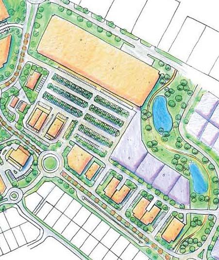
Commercial - Light Industrial Precinct
STRUCTURE PLAN

CONTENTS
1.0   Introduction ........................................................................................................................... 1
      1.1       Background ................................................................................................................ 1
2.0   Physical Context ................................................................................................................... 2
      2.1       Site and Situation ....................................................................................................... 2
      2.2       Land Tenure ................................................................................................................ 2
      2.3       Landform .................................................................................................................... 2
3.0   Statutory Context ................................................................................................................. 4
      3.1       Statement of Planning Policy No. 1 ......................................................................... 4
      3.2       State Planning Strategy............................................................................................. 4
      3.3       Greater Bunbury Region Scheme ............................................................................ 5
      3.4       Bunbury Wellington Region Plan and Greater Bunbury Structure Plan .................. 5
      3.5       Shire of Harvey District Town Planning Scheme No.1(TPS No.1) ........................... 5
      3.7       Treendale District Centre Structure Plan ................................................................. 9
4.0   Concept Development ..................................................................................................... 12
      4.1       Design Philosophy ................................................................................................... 12
      4.2       Relationship to District Centre ................................................................................ 12
      4.3       Interface with Australind Bypass ............................................................................ 12
      4.4       Interface with Residential Landuses ...................................................................... 14
      4.5       Servicing.................................................................................................................... 14
                 4.5.1         Roads ........................................................................................................ 14
                 4.5.2         Drainage ................................................................................................... 14
                 4.5.3         Sewerage ................................................................................................. 15
                 4.5.4         Water Supply ............................................................................................ 15
                 4.5.5         Power ........................................................................................................ 15
                 4.5.6         Telecommunications ............................................................................... 15
                 4.5.7         Gas ............................................................................................................ 15
      4.6       Design Guidelines .................................................................................................... 15
5.0   Implementation .................................................................................................................. 16
      5.1       Structure Plan Approval .......................................................................................... 16
      4.6       Design Guidelines .................................................................................................... 22
      4.7       Application of Guidelines ....................................................................................... 22
      4.8       Design Guideline Elements ..................................................................................... 22

                                                                                                                                                 i
Commercial - Light Industrial Precinct
STRUCTURE PLAN

L I S T O F FI GU RES
Figure 1     Location Plan .............................................................................................................. 3
Figure 2     Extract from Greater Bunbury Region Scheme ...................................................... 6
Figure 3     Greater Bunbury Structure Plan ................................................................................ 7
Figure 4     Existing Zoning ............................................................................................................. 8
Figure 5     Treendale Farm Structure Plan................................................................................ 10
Figure 6     District Centre Structure Plan .................................................................................. 11
Figure 7     Subdivision Concept Plan ....................................................................................... 13
Figure 8     Typical Cross Section ............................................................................................... 14
Figure 9     Structure Plan Policy Statements ............................................................................ 21
Figure 10    Precinct Plans and Statements ............................................................................... 22

L I S T O F A P P EN D I C ES
Appendix A Certificates of Title
Appendix B      Zoning Table Extracts
Appendix C Design Guidelines

                                                                                                                                          ii
Commercial - Light Industrial Precinct
STRUCTURE PLAN

1.0         I nt ro d u ct i o n

1.1     Background

The Shire of Harvey is experiencing an extended period of significant economic and urban
growth in the Australind Urban Corridor. It is timely that provision be made for an adequate
level of services to support this growth.

Approval of this structure plan by both Council and the Western Australian Planning Commission
(WAPC) will establish the framework for future rezoning, subdivision and development.

                                                                                          1
Commercial - Light Industrial Precinct
STRUCTURE PLAN
2.0 P h ysi ca l C o n text
2.1 Site and Situation
The subject land is situated in the Eaton/Australind Urban Growth Corridor extending northward
from the City of Bunbury (see Figure 1 – Location Plan).
The subject land is located within urban expansion areas of Treendale and Kingston and will
eventually link south across the Collie River to Millbridge, the Peninsula and Eaton.
2.2 Land Tenure
The subject land is located of two titles in separate ownership. The land is described as Lots 201
on deposited plan 37204 and Lot 9010 on deposited plan 51961 (see Appendix A – Certificate
of Titles).
2.3 Landform
The proposed “Commercial Light Industrial Precinct” site is situated on a cleared area.
The site is extremely flat with a uniformed elevation of 13.8 metres AHD.
Geotechnical investigations have indicated that there are no acid sulphate soils in the area
and that the land form does not impose significant servicing constraints.
2Commercial - Light Industrial Precinct
STRUCTURE PLAN
Figure 1
Location Plan
3Commercial - Light Industrial Precinct
STRUCTURE PLAN
3.0 St a t u t o ry C o ntext
3.1 Statement of Planning Policy No. 1
The Statement of Planning Policy No. 1 is the State planning framework. It incorporates the
State Planning Strategy and existing regional policies and plans into an ordered hierarchy
for decision making on land use and development. As a Statement of Planning Policy, the
Commission and Local Governments’ must have “due regard” to the provisions when making
decisions on planning matters.
3.2 State Planning Strategy
The State Planning Strategy was adopted by the Western Australian Planning Commission in
December 1997. It is designed to provide a strategic guide for land use planning throughout
the State through to the year 2029. The strategy sets out:
• A common vision for development in the State and for the regions within it.
• Provides a guide to the State Government on its land use planning response and on the
programs and actions required to achieve the visions set out in the strategy.
• Identifies the likely changes and prepares for them.
• Establishes the mechanisms to ensure the strategy is implemented and kept current.
The State Planning Strategy’s vision is to:
“…significantly contribute to the quality of life of all Western Australians in the years to
2029, by using the landuse planning system to facilitate and contribute to regional wealth;
the preservation and enhancement of the environment; and the building of dynamic and
safe communities which nurture human activity.” (Page 2)
The Strategy recognises that the South West Urban System (extending from Perth, south to
Bunbury, Busselton and Albany) will be subject to substantial development pressure. It requires
the area to be managed by developing more sustainable and identifiable new communities,
protection of natural resource areas and reinforcement of strategic transport routes.
4Commercial - Light Industrial Precinct
STRUCTURE PLAN
3.3 Greater Bunbury Region Scheme
The Greater Bunbury Region Scheme provides regional level statutory controls for the Greater
Bunbury Area.
Figure 2 - Greater Bunbury Region Scheme identifies the western portion of the subject land
as “Urban” and the balance as “Urban Deferred”. This land use designation incorporates “…
areas in which a range of activities, including residential, commercial, recreational and light
industrial are undertaken.”
3.4 Bunbury Wellington Region Plan and Greater Bunbury Structure Plan
The Bunbury – Wellington Region Plan and Greater Bunbury Structure Plan were endorsed by
State Cabinet in 1995. They provide a framework in which Local Government Town Planning
Schemes have been evaluated. Figure 3 - Greater Bunbury Structure Plan identifies the subject
land in its wider context.
The Greater Bunbury Structure Plan includes the subject land within planning unit CO6 which
is identified for “… medium – long term urban expansion, with a District Commercial Centre,
Light Industrial Area and wide reserves along the river”. Planning guidelines also recommend
a requirement for the Structure Plan.
The unit statement also includes a limitation on the size of the proposed District Centre to
neighbourhood size until at least the year 2006, but encouraged the early establishment of
local shopping and district level business and community service functions. In addition, it
promotes “local shopping and district level business, community service functions” as well as
“local commercial and civic facilities” within the District Centre Precinct.
3.5 Shire of Harvey District Town Planning Scheme No.1(TPS No.1)
The Shire of Harvey Town Planning Scheme No.1 was gazetted on the 12th of November
1996. The majority of the subject land and surrounding Treendale neighbourhood is zoned
“Residential Development” (see Figure 4 – Existing Zoning). The eastern portion is zoned
“General Farming”. The southern portion of “General Farming” zoned land is presently the
subject of Town Planning Scheme Amendment No.70. This amendment is waiting gazettal. The
land subject to this structure plan will be subject to a seperate amendment proposal.
5Commercial - Light Industrial Precinct
STRUCTURE PLAN
Figure 2
Extract from Greater Bunbury Region Scheme
6Commercial - Light Industrial Precinct
STRUCTURE PLAN
LEGEND MYALUP VE Y
RI
V
H AR
E
IN
DR A
R
D I V ER S I ON
Parks, Recreation And Drainage
ROAD
Areas Under Consideration For Conservation
Scenic Protection And Reservation
Tourism And Recreation Development
Rural Residential
SUBJECT TO FUTURE
Special Amenity Area ENVIRONMENTAL
ASSESSMENT AND
Existing Urban KEMERTON PORT
INVESTIGATIONS
Future Urban (Category A) WELLESLEY
Future Urban (Category B) BINNINGUP
RO
COAST
AD
Regional Centre
Central Business District
District Centre
WELLESLEY
Mixed Business Area
Harbour And Port Related Industries TREASURE
Mixed Use Buffer ROAD
Industrial SHIRE
Rural
KEMERTON
OLD
Special Development Area
R I VER
Conservation/Landscape Value
Major Service Corridor RO
AD
Public Purposes (Denoted As Follows) :
H.S. High School MARRIOTT ROAD
P.S.E. Post-Secondary Education
P. Prison
OF
H. Hospital
C. Cemetery
E S L EY
R. Regional Recreation Centre Waterloo
Head
A. Aerodrome
L L
Regional Refuse
E
Disposal Site
Waste Water Treatment Works
W
And Indicative Buffer R
VE
RI
Major Surface Water Catchment Boundary UNS W I C K HARVEY
BR
Major River
ROAD
Primary Distributor LESCHENAULT
District Distributor (Arterial) C.
District Distributor (Subarterial)
ROAD H.S.
COAST
ESTUARY
Railway RIS
PA SUBJECT TO DECOMMISSIONING
Local Government Boundary H.S.
OF WASTE WATER TREATMENT
WORKS (See Report)
Port AUSTRALIND
RA
YM
ON
D ROAD
CO
L E
R IV R
LIE
Samphire
D
Bay
R I V ER
OL
Point Pelican
Casuarina
OUTER Turkey Point
HARBOUR Point SUBJECT TO DECOMMISSIONING
CO OF WASTE WATER TREATMENT
L LI E
WORKS (See Report)
KOOMBANA Vittoria
BAY Bay H.S.
INNER EATON
R
HARBOUR
D
KO
OM Y
B AR
H.S. AN TU
A ES
BL
AY
HW
AI
HIG
DR
R
FINAL ALIGNMENT OF
ST
SOUTH WESTERN HIGHWAY
TO BE DETERMINED BY
Big
Swamp CITY GLEN IRIS ER
N
SPECIAL STUDY H.S. WES T
H
SOUT
C.
"ZONINGS" AND LAYOUT WITHIN PICTON
AND PRESTON AREAS MAY VARY AFTER
FURTHER STUDY OF THE SCOPE OF
NORT H FUTURE INDUSTRY
H.S.
OF
OC
SHIRE
EA N
PRESTON
B OY ANU
SUBJECT TO CURRENT The
ENVIRONMENTAL H.
ASSESSMENT
Maidens R. P.S.E.
H I GHWAY
DR IV E
OF
DA
P
A.
RD
PR
AN
BUNBURY
ES
ROAD
UP
TO N
BUFFER AREA SUBJECT
TO DETAILED STUDY H.S.
P. DARDANUP
CENTENARY ROAD
BY WATER AUTHORITY
RO
SO
AD
UT
LL
H
SS E
R IVE R
GELORUP
BU
WE
Dalyellup
H.S. H.S.
ST
Beach
ER
HAR
EWO
N
OD
ROA
D
H.S.
HIG
HW
in
AY
D ra
ok
F i ve M i le Br
o
SHIRE Ministry for Planning
WESTERN AUSTRALIA
Rush
Y
Muddy Swamp
WA
Lake
GH
Bunbury-Wellington
HI
Lake
Minninup
Beridup
OF Region Plan
Cokelup
Beach Swamp
GREATER BUNBURY
L
EL
STRATHAM
SS
CAPEL STRUCTURE PLAN
BU
OCTOBER 1995
2500 0 2500 5000
FINAL ROAD ALIGNMENT SUBJECT TO metres
DETAILED STUDY BY MAIN ROADS W.A.
Figure 16
Figure 3
Greater Bunbury Structure Plan
7Commercial - Light Industrial Precinct
STRUCTURE PLAN
Shire of Harvey
Town Planning
Scheme No. 1
Figure 4
Existing Zoning
8Commercial - Light Industrial Precinct
STRUCTURE PLAN
3.6 Treendale Structure Plan
The Treendale Farm Structure Plan dated April 2001 has been endorsed by the Shire of Harvey
and the Western Australian Planning Commission (see Figure 5 – Treendale Farm Structure
Plan).
Subsequent to the adoption of this document, minor modifications to the Structure Plan have
been ongoing. These do not significantly impact on this site. Figure 5 depicts the current
structure plan.
The philosophy of the Treendale Farm Structure Plan encompasses the following objectives:
• To protect the environmental qualities of the Collie and Brunswick Rivers associated
wetlands and flood plains;
• To build upon the local and regional planning for the area and create a vibrant district
centre that will act as a cultural and commercial focus for the locality;
• To be innovative in the application of urban design principles and incorporate key
aspects of the Liveable Neighbourhoods Community Design Code;
• To provide a mechanism which will allow refinement and staging of the Treendale Farm
Structure Plan;
• To provide for strong pedestrian connectivity utilizing a permeable road network, open
space linkages and conservation areas;
• To develop an integrated open space and drainage network which maximizes ground
water recharge at source and ensure urban runoff is stripped of nutrients prior to
discharging; and
• Given the flat topography of the site, artificial focuses, or landmarks, are to be created
by strategic use of open space and concentrating more intensive land uses at specific
points and emphasizing these locations by adopting regid geometric road layouts.
The Structure Plan has been developed to promote a broad range of employment generated
land uses to foster a vibrant and self sustaining community including district and local
commercial centres, industrial, service commercial and mixed business areas.
3.7 Treendale District Centre Structure Plan
The subject land abuts the proposed Treendale District Centre site (see Figure 6 – Treendale
District Centre Structure Plan). This structure plan has been adopted by the Shire of Harvey
and the Western Australian Planning Commission. It provides for detailed consideration of:
• floor space;
• streetscape;
• building design principles;
• built form; and
• servicing.
9Commercial - Light Industrial Precinct
STRUCTURE PLAN
Figure 5
Treendale Farm Structure Plan
10STRUCTURE PLAN
R80
R80
R80
R80
Commercial - Light Industrial Precinct
R80
R80 Subject to separate
structure planning
* *
R80
* * RESIDENTIAL
RETAIL
OFFICE MEDICAL
MIXED USE
FOOD & ENTERTAINMENT
COMMUNITY USE / RESERVE
SHOWROOMS NURSERY
OFFICE RESIDENTIAL
R80 R80
R80 R80 OFFICE
POS RESERVE
ENCLOSED PEDESTRIAN ENVIRONMENT
(to remain open during standard centre operating hours)
USES IN THIS LOCATION SHOULD ATTEMPT TO ACTIVATE
AFTER HOURS ACTIVITY
LANDMARK BUILDING SITE
*
R80 R CODE DENSITY
BUS STOP
INTEGRATOR B
INTEGRATOR B - TOWN CENTRE MAIN STREET
Figure 6
District Centre Structure Plan
11Commercial - Light Industrial Precinct
STRUCTURE PLAN
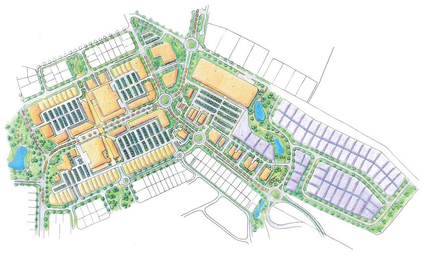
4.0 C o n ce pt D e velopment
4.1 Design Philosophy
The design philosophy of the “Commercial – Light Industrial Precinct Concept Structure Plan”
is to provide a high level of local amenity and provide a clear demarcation between private
and public land. (See Figure 7 – Concept Plan).
The proposed layout ensures that no lots back directly onto the landscaped highway buffers.
The proposed public open space corridor provides high levels of accessibility through the
subject land to future “Community Purpose” sites and provides a safe linkage to the adjoining
District Centre site.
The proposal depicts a range of lot sizes to ensure that a wide range of activities can be
accommodated on the subject land.
4.2 Relationship to District Centre
The concept plan depicts a complementary and integrated transition of land uses between
“District Centre” uses on the western boundary and “Light Industrial” land to the north. The
concept plan shows a hardware store to mediate uses and define the north western interface
edge with existing light industrial uses. The western edge provides opportunity for built form to
address the street and provide an attractive interface with the adjoining community purpose
site and screen car parking from the street environment.
The south western section includes a potential fast food precinct that will interface with the
proposed fast food site within the district centre. I high degree of streetscape amenity can
be achieved through the limited use of crossovers and orientation of buildings to address the
public realm. The balance of the site serviced by internal roads to additional setbacks and
landscaping treatments to ensure an attractive interface with abutting future residential land
use to the south.
4.3 Interface with Australind Bypass
The proposed concept plan is consistent with the intent of the Treendale Farm Structure Plan
which identifies a “POS and Landscape Buffer” along the Australind Bypass interface. The
proposed concept plan depicts a 20m POS strip abutting the Bypass reserve which is intended
to contain a landscaped bund (see Figure 8 – Typical Cross Section). This “buffer” is further
expanded by the use of a 20m wide internal servicing road, which maximizes the opportunity
for buffering and screening development from the Bypass, while providing scope for passive
surveillance.
121 Hardware Store
2 Community Purpose
3 Fast Food
4 Service Station
5 Open Space / Drainage Corridor
STRUCTURE PLAN
2
1
Dit
ch
4 ing
ha
3 m
Commercial - Light Industrial Precinct
3 Pla
ce
3
5
Figure 7
13
Subdivision Concept PlanCommercial - Light Industrial Precinct
STRUCTURE PLAN
Figure 8
Typical Cross Section
4.4 Interface with Residential Landuses
The proposed concept plan area abuts residential land to the south. The concept plan design
appropriately acknowledges the residential interface by providing:
• Internal servicing roads to appropriately separate residential and “commercial” vehicle
movements;
• Provision of an interface with the “community purpose” site for a significant portion of the
residential interface. This provides opportunity for passive surveillance, direct access to
community facilities and opportunities for open aspects and high levels of streetscape
amenity; and
• The stepping of lot sizes and potential larger scale development away from the residential
interface. The design effectively screens future “Light Industrial” uses from the residential
streetscape.
4.5 Servicing
4.5.1 Roads
The site will be serviced by local roads with a minimum reserve of 20 metres.
4.5.2 Drainage
The Treendale drainage system is a piped system which discharges into an existing bio-retential
swale. This has been constructed as part of the Treendale residential development. The
existing drainage system has been designed to accommodate drainage flows generated by
the subject land.
14Commercial - Light Industrial Precinct
STRUCTURE PLAN
4.5.3 Sewerage
A sewerage strategy has been developed for the entire Treendale estate based on current
planning and discussions with the Water Corporation.
4.5.4 Water Supply
A water supply strategy has been developed for the entire Treendale estate based on current
planning and discussions with Water Corporation.
4.5.5 Power
The power supply strategy has been developed for the entire Treendale estate. This is based
on planning and discussions with Western Power and involves a series of transformers across
the site.
4.5.6 Telecommunications
A telecommunications strategy has been developed for the entire Treendale estate based on
current planning and discussions with Telstra.
4.5.7 Gas
A gas reticulaion strategy also been developed for the entire Treendale estate based on
current planning and discussions with Alinta Gas.
4.6 Design Guidelines
Appendix C contains design guidelines and detailed area plans that provide controls for future
development ensuring a high amenity outcome.
The guidelines have been prepared to address issues associated with landuses, setback,
building form and access to ensure a high quality interface with adjoining land areas/district
centre and minimise potential for land use conflict.
15Commercial - Light Industrial Precinct
STRUCTURE PLAN
5.0 I m pl e me n t a t i on
5.1 Structure Plan Approval
The Shire of Harvey Town Planning Scheme No.1 stipulates the need to prepare a structure
plan prior to subdivision or development occurring. The structure plan and implementation
provisions follow this section. (See Figures 9 & 10)
5.2 Zoning
It is proposed to rezone the land as part of town planning scheme amendment. This process
will provide the statutory controls to guide future subdivision and development.
5.3 Subdivision
Subdivision is to occur generally in accordance with the structure plan. It is expected that
design guidelines will be required as a condition of subdivision to control matters of detailed
design for future development.
5.4 Development Approvals
Development shall be in accordance with the structure plan provisions, scheme requirements
and approved Design Guidelines.
16SHIRE ADOPTION
This Treendale District Centre Structure Plan has been
adopted by the Shire of Harvey on
WAPC ENDORSED STRUCTURE
PLAN
To provide a framework for future detailed
planning at the subdivsion and development
STRUCTURE PLAN
stage.
Date
Delegated under s.16 of the Planning &
Development Act 2005
Commercial - Light Industrial Precinct
STR UC TUR E PL AN POLICY STATEM E NTS 6) All development with a street frontage, shall actively address the street environment,
including a clear point of entry.
1) Development and subdivision shall be generally in accordance with the Commercial 7) All development is to be accompanied by the required level of parking to the
Precinct Structure Plan Map and relevant Policy Statements. satisfaction of the Local Government.
2) Design Guidelines shall be prepared prior to any development or subdivision 8) The permissibility of uses shall be in accordance with the respective zoning Tables
occurring to the satisfaction of the Local Government. The Guidelines shall have under the Shire of Harvey Town Planning Scheme No.1.
regard to relevant design principles and should include, but not be limited to the 9) Staging of development is to occur in an orderly and proper manner and shall
following elements of landscaping, building orientation, open space interface demonstrate and implement adequate access, servicing and landscaping
treatments and screening of servicing areas from streetscapes. provision.
3) Road design and parking access/egress shall be designed and constructed in 10) A Landscape Strategy shall be prepared and implemented at the time of
accordance with the requirements of Liveable Neighbourhoods and Austroads to development to ensure landscaping within public and private spaces is designed
the satisfaction of the Local Government. consistently for frontages along the southern and western street frontages.
4) Pedestrian and cyclist facilities and access into and around Commercial – Light 11) The design of buildings adjoining public spaces shall have regard to providing
Industrial Precinct Structure Plan is to be provided in accordance with the structure adequate security and public safety in accordance with the principles established
plan at the time of development or detailed subdivision. in Planning Bulletin No.79 Designing Out Crime Planning Guidelines.
5) Development shall demonstrate and implement best practice water sensitive 12) Public Open Space reserve’s are to be vested to the Crown free of cost at the
urban design to the satisfaction of the Local Government, in consultation with time of development or subdivision.
Department of Water.
17
13) Solar design principles are encouraged.
Figure 9
Structure Plan Policy StatementSTRUCTURE PLAN
Commercial - Light Industrial Precinct
WESTERN PRECINCT EASTERN PRECINCT
Statement of Intent Statement of Intent
This precinct is to provide a high quality streetscape and built form environment that complements the functions This precinct is to provide a range of commercial and limited light industrial uses to provide a transitional area
and design elements of the District Centre between Treendale’s residential precincts and “Light Industrial” zoned land to the north.
Key Objective Key Objective
Create a high quality street environment along the “Kingston Drive Extension”. To minimise potential for land use conflict between abutting land uses and provide an appropriate interface
between the highway and future access into Treendale.
Design Principles
Design Principles
• Building design along “Kingston Drive Extension” to acknowledge the importance of the road as a “gateway”
into the District Centre. • To provide a landscape buffer between the highway
• To provide a high standard of pedestrian and cycle linkage to the District Centre and residential surrounds • Nursery uses to demonstrate compliance with buffer guidelines. When a nursery use proposes a reduced
• Car parking areas to be located and designed to ensure a high quality and safe streetscape. buffer area, a site specific environmental assessment will be required to be undertaken to the satisfaction of
the Shire.
Precinct Specific Design Guidelines
Design Guidelines
Building Facades
• Additional Uses of Transport Depot, Builders Yard, Vehicular Repair Station shall be contained within a built
a) Facades visible from “Kingston Drive Extension” shall: form setting that:
i. Demonstrate a high level of detailing or decoration in design, structure, colour and materials to provide - Complies with the design guidelines
and enhance interest and visual amenity;
- screens servicing and storage areas from the street environment;
ii. Include glazing for at least 40% of the total length of the building façade;
- prohibits the display of goods within the front setback area
iii. Include awnings/verandahs and other roof treatments to break vertical lines and provide shelter for
pedestrians; and
iv. Restrict the use of roller doors to side or rear elevations.
Lighting
a) Strobe lighting, to attract attention, will not be permitted.
Landscaping
18
a) Landscaping within front setback areas for lots with frontages on “Kingston Drive Extension and Grand Figure 10
Entrance shall be prepared and implemented in accordance with an approved landscape strategy to
ensure consistency and a high amenity interface with the district centre and residential streets. Precinct Plans and StatementsCommercial - Light Industrial Precinct
STRUCTURE PLAN
APPENDIX A
CERTIFICATE OF TITLESLANDGATE COPY OF ORIGINAL NOT TO SCALE Tue Jul 24 08:50:24 2007 JOB 28763278
LANDGATE COPY OF ORIGINAL NOT TO SCALE Tue Jul 24 08:51:23 2007 JOB 28763304
LANDGATE COPY OF ORIGINAL NOT TO SCALE Tue Jul 24 08:51:23 2007 JOB 28763304
Commercial - Light Industrial Precinct
STRUCTURE PLAN

                               APPENDIX B

                  ZONING TABLE EXTRACTS
TABLE 14 - ZONING AND DEVELOPMENT STANDARDS
ZONING AND DEVELOPMENT STANDARDS OTHER COMMERCIAL - SHOWROOM
POLICY STATEMENT
Intended for the establishment of showroom type uses, which are inappropriate to the Shop Zone because of the larger land areas required, but are not suited to
Industrial Zones.
DEVELOPMENT STANDARDS
Minimum Minimum Minimum Lot MINIMUM BOUNDARY SETBACKS Minimum Car Minimum
Lot Areas Effective area for Front Rear Sides Parking Land- OTHER REQUIREMENTS
Frontage Dwelling Spaces scaping
Unit
2 2
1000m 20m N/A 9m In accordance with the 1 space per 50m 10% of Clause 7.1
For an explanation of symbols refer to Clause Building Code of display area GFA site
4.2.2 Australia
LAND USE CATEGORIES NOTE: Unless otherwise specified against a particular use below, the above standards will apply to this Zone.
1 CARETAKER’S HOUSE IP
2
2 OFFICE AA 1 per 40m GFA
3 SHOWROOM P
4 TRADE DISPLAY P
5 WAREHOUSE P
6 CAR, BOAT, CARAVAN AND AA As determined by
MACHINERY SALES Council
2
7 SERVICE STATION AA 1500m 40m 3m each
side
2
8 ROAD HOUSE AA 1500m 40m 3m each
side
9 FUNERAL PARLOUR P
10 NURSERY P
11 CAR PARK IP 2m 2m 1.5 each
side
Shire of Harvey TPS 1 Page No. 60TABLE 15 - ZONING AND DEVELOPMENT STANDARDS
ZONING AND DEVELOPMENT STANDARDS OTHER COMMERCIAL - SHOWROOM (CONTINUED)
POLICY STATEMENT
Intended for the establishment of showroom type uses, which are inappropriate to the Shop Zone because of the larger land areas required, but are not suited to
Industrial Zones.
DEVELOPMENT STANDARDS
Minimum Minimum Minimum Lot MINIMUM BOUNDARY SETBACKS Minimum Car Minimum OTHER REQUIREMENTS
Lot Areas Effective area for Front Rear Sides Parking Spaces Land-
Frontage Dwelling Unit scaping
2 2
1000m 20m N/A 9m In accordance with the 1 space per 50m 10% of Clause 7.1
For an explanation of symbols refer to Clause Building Code of display area GFA site
4.2.2 Australia
LAND USE CATEGORIES NOTE: Unless otherwise specified against a particular use below, the above standards will apply to this Zone.
2
12 SERVICE PREMISES AA 1 per 20m GFA
13 RECREATION (PUBLIC) P
14 PUBLIC AMUSEMENT P
15 GARDEN CENTRE P
16 HEALTH CENTRE P
17 PRIVATE RECREATION AA At Council
discretion
18 BETTING AGENCY AA
19 CAR SALES PREMISES P
20 CONSULTING ROOMS AA 6 for 1 GP
10 for 2 GP
4 for 1 DPC
6 for 2 DPC
21 MEDICAL/DENTAL CLINIC AA 5 per Practitioner
22 MARKET AA
Shire of Harvey TPS 1 Page No. 61TABLE 16 - ZONING AND DEVELOPMENT STANDARDS
ZONING AND DEVELOPMENT STANDARDS LIGHT AND SERVICE INDUSTRY
POLICY STATEMENT
Primarily industry which will not affect the amenity of nearby areas through the emission of wastes and which do not require independent power sources. A
relatively high standard of building facade will be sought. Council will co-ordinate the position of crossovers and landscaping on the street frontages of adjoining
premises.
DEVELOPMENT STANDARDS
Minimum Minimum Minimum Lot MINIMUM BOUNDARY SETBACKS Minimum Car Minimum OTHER REQUIREMENTS
Lot Areas Effective area for Front Rear Sides Parking Spaces Land-
Frontage Dwelling Unit scaping
2 2
1000m 20m N/A 9m In accordance with the 1 space per 50m 10% of Clause 7.1
For an explanation of symbols refer to Clause Building Code of GFA site Schedule 5 applies.
4.2.2 Australia
LAND USE CATEGORIES NOTE: Unless otherwise specified against a particular use below, the above standards will apply to this Zone.
1 LIGHT INDUSTRY P
2 SERVICE INDUSTRY P
2
3 SHOWROOM P 1 per 50m GFA
4 TRADE DISPLAY P
2
5 WAREHOUSE P 1 per 50m GFA
6 FUNERAL PARLOUR P
7 BUILDER’S YARD P
8 MOTOR VEHICLE REPAIR P
STATION
9 CAR WASH P
10 NURSERY P
2
11 SERVICE STATION AA 1500m 40m
12 PUBLIC AMUSEMENT P
13 DRIVE IN CINEMA AA At Council’s 3m wide Screen face not to be visible to passing
discretion strip on traffic. Access not to be via residential
periphery streets.
Shire of Harvey TPS 1 Page No. 62TABLE 17 - ZONING AND DEVELOPMENT STANDARDS
ZONING AND DEVELOPMENT STANDARDS LIGHT AND SERVICE INDUSTRY (CONTINUED)
POLICY STATEMENT
Primarily industry which will not affect the amenity of nearby areas through the emission of wastes and which do not require independent power sources. A
relatively high standard of building facade will be sought. Council will coordinate the position of crossovers and landscaping on the street frontages of adjoining
premises.
DEVELOPMENT STANDARDS
Minimum Minimum Minimum Lot MINIMUM BOUNDARY SETBACKS Minimum Car Minimum OTHER REQUIREMENTS
Lot Areas Effective area for Front Rear Sides Parking Spaces Land-
Frontage Dwelling Unit scaping
2 2
1000m 20m N/A 9m In accordance with the 1 space per 50m 10% of Clause 7.1
For an explanation of symbols refer to Clause 4.2.2 Building Code of Australia GFA site Schedule 5 applies.
LAND USE CATEGORIES NOTE: Unless otherwise specified against a particular use below, the above standards will apply to this Zone.
15 CAR, BOAT, CARAVAN AND P 7.5m 1 per 50m2
SALES PREMISES display area
16 CARETAKER’S DWELLING IP
17 OFFICE IP
18 LAUNDRY P
19 TRANSPORT DEPOT P
20 CAR PARK IP 2m 2m 1.5 each
side
2
21 SERVICE PREMISES P 1 per 20m GFA
22 VETERINARY HOSPITAL P
23 HEALTH CENTRE P
2
24 LUNCH BAR AA 1 per 15m GFA Clause 7.2
25 FACTORY UNIT BUILDING P 2000m2 3 per unit or 1 bay
2
per 50m
26 RELOCATED DWELLING AA
2
27 PUBLIC WORSHIP PLACE OF SA 1000m 20m 1 per five 15% of Buildings should be designed to blend in
AMD 22 GG 5/12/97 individual seats the site with the existing or proposed
development in the industrial area.
Shire of Harvey TPS 1 Page No. 63TABLE 38 - ZONING AND DEVELOPMENT STANDARDS
ZONING AND DEVELOPMENT STANDARDS SERVICE STATION
POLICY STATEMENT
It is Council policy to encourage service stations to be developed in association with other commercial and industrial uses. Where this is not the case specific zoning will
be required because of the traffic nuisance pertaining to particular sites.
DEVELOPMENT STANDARDS
Minimum Minimum Minimum Lot MINIMUM BOUNDARY SETBACKS Minimum Car Minimum OTHER REQUIREMENTS
Lot Areas Effective area for Front Rear Sides Parking Spaces Landscap
Frontage Dwelling Unit -ing
For an explanation of symbols 1500m2 40m N/A 11m 7.5m 3m each 6 10%
refer to Clause 4.4.2 side
LAND USE CATEGORIES NOTE: Unless otherwise specified against a particular use below, the above standards will apply to this Zone.
1 SERVICE STATION P
2 ROADHOUSE P
3 CAR WASH AA
4 SHOP AS PART OF SERVICE IP
STATION
5 CARETAKER’S HOUSE IP
6 MOTOR REPAIR STATION IP
7 CAR PARK AA 2m 2m 1.5 each
side
2
8 CAR, BOAT, CARAVAN AND AA 5 one side 1 per 20m display
MACHINERY SALES area
Shire of Harvey TPS 1 Page No. 84Commercial - Light Industrial Precinct
STRUCTURE PLAN
APPENDIX C
DESIGN GUIDELINES9HKLFXODU$FFHVV5HVWULFWLRQV
8QLIRUP)HQFLQJ
6HWEDFNV
Minimum 2.5m SUBJECT TO FUTURE GUIDELINES
Minimum 5m
: ( 6 7 ( 5 1 3 5( & , 1 & 7 EASTERN PRECINCT
Statement of Intent Statement of Intent
7KLVSUHFLQFWLVWRSURYLGHDKLJKTXDOLW\VWUHHWVFDSHDQGEXLOWIRUPHQYLURQPHQWWKDWFRPSOHPHQWVWKHIXQFWLRQV This precinct is to provide a range of commercial and limited light industrial uses to provide a transitional area
DQGGHVLJQHOHPHQWVRIWKH'LVWULFW&HQWUH between Treendale’s residential precincts and “Light Industrial” zoned land to the north.
Key Objective Key Objective
&UHDWHDKLJKTXDOLW\VWUHHWHQYLURQPHQWDORQJWKH´.LQJVWRQ'ULYH([WHQVLRQµ 7RPLQLPLVHSRWHQWLDOIRUODQGXVHFRQÁLFWEHWZHHQDEXWWLQJODQGXVHVDQGSURYLGHDQDSSURSULDWHLQWHUIDFH
between the highway and future access into Treendale.
Design Principles
Design Principles
%XLOGLQJGHVLJQDORQJ´.LQJVWRQ'ULYH([WHQVLRQµWRDFNQRZOHGJHWKHLPSRUWDQFHRIWKHURDGDVD´JDWHZD\µ
LQWRWKH'LVWULFW&HQWUH 7RSURYLGHDODQGVFDSHEXIIHUEHWZHHQWKHKLJKZD\
7RSURYLGHDKLJKVWDQGDUGRISHGHVWULDQDQGF\FOHOLQNDJHWRWKH'LVWULFW&HQWUHDQGUHVLGHQWLDOVXUURXQGV 1XUVHU\XVHVWRGHPRQVWUDWHFRPSOLDQFHZLWKEXIIHUJXLGHOLQHV:KHQDQXUVHU\XVHSURSRVHVDUHGXFHG
&DUSDUNLQJDUHDVWREHORFDWHGDQGGHVLJQHGWRHQVXUHDKLJKTXDOLW\DQGVDIHVWUHHWVFDSH EXIIHUDUHDDVLWHVSHFLÀFHQYLURQPHQWDODVVHVVPHQWZLOOEHUHTXLUHGWREHXQGHUWDNHQWRWKHVDWLVIDFWLRQRI
the Shire.
3UHFLQFW6SHFLÀF'HVLJQ*XLGHOLQHV
Design Guidelines
%XLOGLQJ)DFDGHV
$GGLWLRQDO8VHVRI7UDQVSRUW'HSRW%XLOGHUVCommercial - Light Industrial Precinct
STRUCTURE PLAN
Design Guidelines
Objectives
a) To develop and maintain an attractive Commercial Precinct fronting the “The
Promenade”;
b) To provide a high standard of visual amenity and provide an attractive and complementary
interface to the District Centre and residential frontages;
c) To achieve a cohesive built environment;
d) To encourage development in a form that will give regard to security of property and the
safety of users; and
e) To encourage buildings to address open space areas and provide passive surveillance
of car parking areas.
Application of Guidelines
a) The Guidelines apply to the area detailed in the Development Guide Plan referenced as
number 11072P-MP-03; and
b) The Guidelines are to be read in conjunction with the Development Guide Plan and the
relevant Scheme provisions applicable to the site.
Design Guideline Elements
The Commercial Precinct is divided into three distinctive precincts. Specific design objectives
and elements relevant to each precinct are contained on the Development Guide Plan.
General element provisions applicable to the entire Commercial Precinct are set out in the
following Design Elements.
Where there is a conflict between the intent of the general guidelines and the specific
guidelines and elements presented on the Development Guide Plan, the specific guidelines
and elements shall prevail.
General Guidelines
The general provisions of the Guidelines are set out in each of the following Design Elements:
Statement of Intent – Key Objective
The Commercial Precinct is to provide a high quality streetscape and built form environment
that complements District Centre activity and provides a positive interface with open space
environments and responds sympathetically with adjoining residential landholdings.Commercial - Light Industrial Precinct
STRUCTURE PLAN
ELEMENT 1 – STREETSCAPE AND BUILT FORM
Setbacks
a) Setbacks shall comply with the Detailed Guide Plan (DGP) where specifically mentioned.
All other setbacks shall be determined in accordance with Table 14 of the Shire of Harvey
Town Planning Scheme No.1;
b) Verandas and awnings may project up to 2.5 metres forward of the setback line and shall
be a minimum of 2.75m above the foot path;
c) Setback areas shall only be used to contain car parking, landscaping and pedestrian
access paths; and
d) Notwithstanding a) above, minor setback variations will be supported where they assist
in breaking the linear form and provide interest.
d) Setback areas shall not be used for the storage of materials, products or by-products or
wastes, the storage of fuel, machinery or plant equipment.
Building Height
a) A building shall not exceed a height of Category C of the Residential Planning Codes.
Facades and Structures
a) All elevations visible from the street are to include a high degree of architectural design
detail at the pedestrian scale;
b) Long straight, unrelieved, horizontal lines should be broken by interesting design devices
to suit a pedestrian environment and the building;
c) Plant rooms, servicing and storage areas shall be screened from the street environment;
d) Roller doors shall generally be positioned to minimise impact on the street elevations. If
a roller door is required to address the street, it shall be restricted to a width of no greater
than 6.5 metres; and
e) Transportable buildings shall be prohibited.
Windows/Glazing
a) The continuity of glazing on street elevations should be broken to provide interest by solid
(opaque) vertical panels, framework and/or strong visual displays;
Entrance
a) Entrances to a building should be clearly visible from the street environment and should
not be obscured by columns, planting or other features. Major doorways should be
evident as such, with minor entrances also easily seen; and
b) Major entrances should include access for people of limited mobility. Access will be
required as under the Building Code of Australia.Commercial - Light Industrial Precinct
STRUCTURE PLAN
Signage
a) All signage structures and signage shall be of a scale that reflects the related development
and be located and maintained in a manner that does not limit sightlines or create
potential for public safety issues;
b) Signs should be integrated within the design of the building or the space in which it is
proposed to be placed where practical;
c) Street numbering shall be integrated within the design of the building or the space in
which it is proposed to be placed; and
d) Signage and advertising on glazed areas shall be limited to 30% of each street frontage.
Signage and advertising on glazed areas shall be of a professional standard and of a
style and theme consistent with other advertising integrated within the design of the
building.
Colours
a) Colour should be used so that every building is different and interesting but not at the
expense of its neighbours; and
b) Colour should differentiate between brick, render and wood surfaces and be used to
highlight articulation or other architectural features where desirable.
Awnings and Verandahs
a) Weather protection on street frontage building façades is to be provided;
b) Verandah roofs should be of solid light impenetrable material and should provide full
shade and shelter from sun, wind and rain; and
c) If verandahs are provided, they and their supports, if any, should be designed to
complement the building’s architecture and scale.
Materials
a) Highly reflective colorbond or zincalume roofs materials are not permitted;
b) Use of external second hand materials shall not be permitted.
Fencing
a) Fencing abutting the Recreation reserve as defined on the Development Guide Plan
shall be 1.8m high and consist of 1.8m high masonry piers with open picket infill above a
750mm high portion of masonry wall;
b) Side fencing abutting the “Public Purpose” site shall be constructed of 1.8m open mesh
fencing with steel pole piers;
c) Front fencing is not supported, unless it is less than 750mm in height, matches with the
design, material and colour of the building façade and forms part of a landscaping
treatment;Commercial - Light Industrial Precinct
STRUCTURE PLAN
d) Side fencing forward of the building line shall be consistent with the theme of the building
in terms of colour and materials, reducing at the building line to a 45 degree angle to a
height not exceeding 1 metre; and
e) No fibro cement fencing is permitted.
ELEMENT 2 – LANDSCAPING
Landscaping Plan
a) A detailed landscaping plan shall be required for developments. The plan shall include
details of planting, lighting and paving. The design of the planting component must
comply with the general guidelines outlined within this document. Information provided
shall include all plant types clearly labelled and located, proposed numbers, sizes and
spacing of plants and details of soil improvement and reticulation.
Street Frontages
a) Landscaping should be in the form of trees and low level plantings that will not block
views between the road and buildings at eye level;
b) A minimum of 20% of the front setback area shall be landscaped;
c) A minimum of 10% of secondary street setbacks areas shall be landscaped; and
d) Landscaping is to apply “Waterwise” principles and predominantly incorporate native
plant species.
Car Parks
a) Any car parking or open areas facing streets shall be enhanced with extensive tree
planting, lighting in accordance with relevant Australian Standards, paving etc so as to
present a quality street frontage.
Lighting and Paving
a) All external lighting of buildings should be designed to complement the character of the
streetscape; and
b) Paving should be used to enhance and identify pedestrian, cycle and vehicular access
ways.
ELEMENT 3 – MOVEMENT AND PARKING
Pedestrian Movement
a) The pedestrian network shall provide a safe and attractive link between buildings and
their respective parking areas; and
b) Development adjacent to footpaths and other pedestrian areas should provide an
attractive and interesting frontage to the route. The use of blank walls, exhaust vents
and mechanical equipment will not be supported where abutting pedestrian ways and
street frontages.Commercial - Light Industrial Precinct
STRUCTURE PLAN
Parking and Access
a) Car parking bays shall be provided in accordance with the Shire of Harvey Town Planning
Scheme No.1;
b) Vehicular access shall be restricted to points as generally indicated on the Development
Guide Plan;
c) Sharing of crossovers is encouraged where practical; and
d) All access ways and car parking areas are to be sealed or paved, marked and drained
to the satisfaction of the Local Government.
ELEMENT 4 – DEVELOPER APPROVAL
a) All building plans in the precinct covered by these design guidelines shall be subject
to approval by the estate developer prior to being submitted to the Shire for planning
approval and/or building licence.
MATTERS NOT CONSIDERED BY THE GUIDELINES
a) Wherever there are matters not considered or deemed questionable in these guidelines,
the Shire of Harvey Town Planning Scheme No.1 shall prevail; and
b) If the matter is not resolved by a) above, then it shall be decided by the Shire of Harvey
Council, unless a right of review is pursued by the proponent.
35You can also read