Public Hearings Committee - June 01, 2021 - Norfolk County
←
→
Page content transcription
If your browser does not render page correctly, please read the page content below
Working together with our community
Page 1 of 12
Public Hearings Committee – June 01, 2021
Subject: 28TPL2020142/ZNPL2020144 – An application has been for a Draft Plan of
Subdivision and Zoning By-Law Amendment to establish a 101 units plan of subdivision.
It is proposed to rezone the subject lands from Development (D) Zone to Urban
Residential Type 2 (R2) Zone and Urban Residential Type 4 (R4) Zone with a special
provision to reduce the exterior side yard setback for corner lots from 6 metres to 3
metres.” AD THOMPSON ROAD INC. on behalf of ROBERT AND THOMAS AND
SCOTT THOMPSON and agent G. DOUGLAS VALLEE LTD. has put forth the
application affecting the lands described as 220 Thompson Road West, Waterford.
Report Number: CD 21-37
Division: Community Development
Department: Planning
Purpose: For Information
Executive Summary:
An application has been received for a Draft Plan of Subdivision comprising a mix of
housing types, including 51 single-detached, 40 semi-detached, and 10 townhouse
dwelling units, for a total of 101 residential dwelling units.
A zoning application has also been submitted to change the current 'Development' zone
to 'Residential Type 2 (R2)' zone and 'Residential Type 4 (R4)' zone with a site-specific
provision.
This report is presented as part of the statutory public meeting required by the Planning
Act. Following further review and any recommended revisions, a subsequent report will
be brought forward containing a recommendation for Council’s consideration.
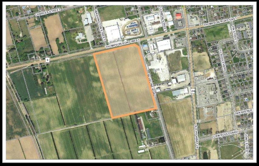
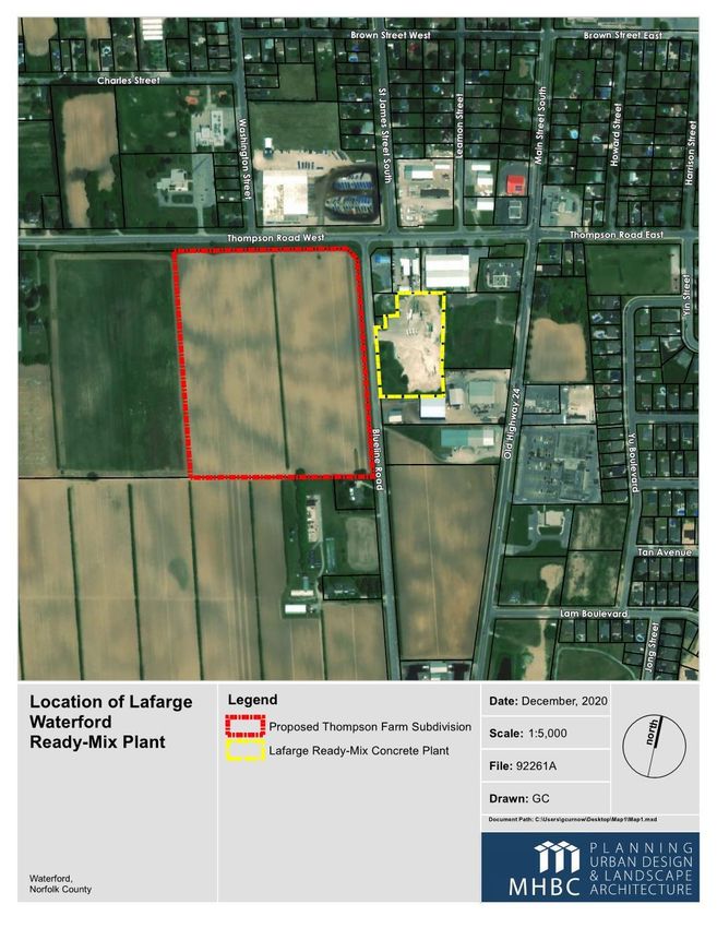
Site Features and Land Use:
The subject lands are within the Waterford urban boundary and located to the west of
Blue Line Road and south of Thompson Road West, in the southwest area of Waterford.
The total area of the subject land is 7.85 hectares, with a gradual slope of approximately
2 meters from the highest elevations from the northerly and southerly property lines
towards the center of the property. The lands abutting to the east are comprised of
various industrial uses including Norfolk Disposal Services Limited, Lafarge Concrete,
Car Wash and Pet Grooming business. The lands to the north, across Thompson Road
West, is a second location for Norfolk Disposal Services Limited. Active cash crop
farming is located to the west and south.
Date Report Template Last Revised: May 22, 2020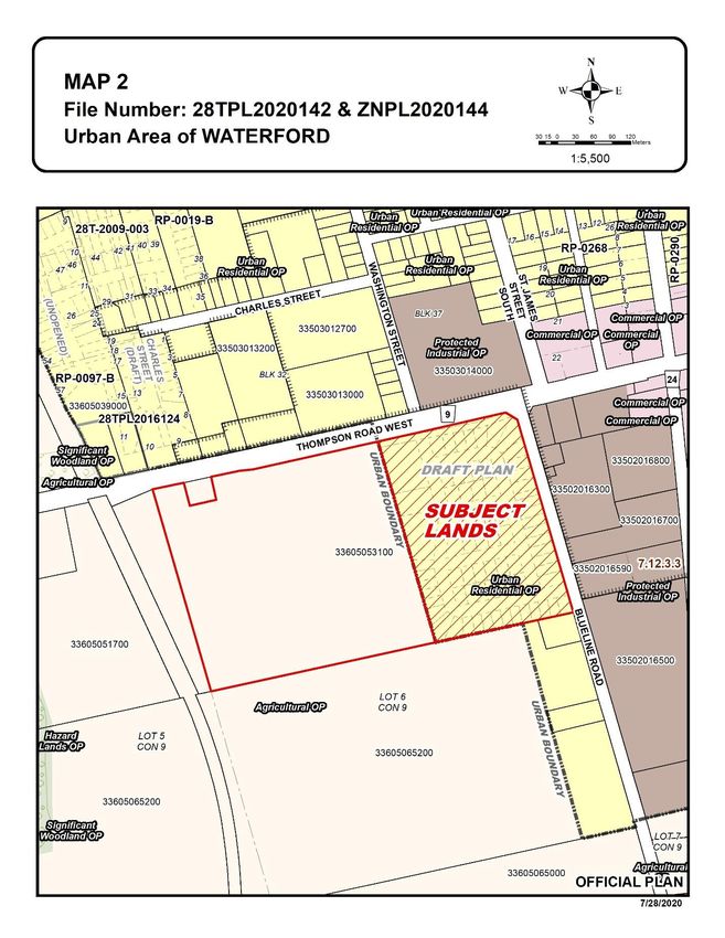
CD 21- 37                                                                    Page 2 of 12

 Figure 1: The subject site at the right side opposite to Lafarge Concrete Industry along
 Blueline Road.

 Figure 2: The subject site at the right side opposite to Norfolk Disposal’s bin and truck
 storage property along Thompson Road West.

 Development Proposal: The proposal is for a draft plan of subdivision containing
 approximately 101 residential dwelling units with a stormwater management pond,
 and a small park area. The proposal includes 51 single detached dwelling units, 40
 semi-detached dwelling units, and 10 street townhouse dwelling units.

 It is proposed to rezone the subject lands from Development Zone (D) to Urban
 Residential Type 2 Zone (R2) and Urban Residential Type 4 Zone (R4) with a special
 provision of reduced exterior side yard to implement the draft plan of subdivision.
CD 21- 37                                                                 Page 3 of 12

                          Figure 3: The proposed subdivision

Discussion: As shown in Figure-3, the proposed subdivision comprises 51 single
detached dwelling units, 40 semi-detached dwelling units, and 10 street townhouse
dwelling units with a density of 12.86 units per hectare. This is close to the minimum
requirement of 15 UPH for single detached residential developments indicated in the
Official Plan policies. The proposed development will be connected to municipal water
and sewer services through public roads.

MOE-D Series Guidelines Analysis: The Land Use Compatibility Assessment, dated
October 28, 2019, prepared by Rubidium Environmental, identifies the adjacent Norfolk
Disposal sites as waste management facilities, not as waste facilities. The Easterly
Norfolk Disposal facility has Environmental Compliance Approval for air and noise and
CD 21- 37                                                                   Page 4 of 12

is identified as a waste disposal site for processing, storage, and transfer of solid
industrial, commercial and residential waste. The report did not include D4 guidelines
and corresponding D1 requirements. The report includes a D6 guidelines analysis but
did not provide mitigation measures. The Agent has been asked to review the following
issues and revise the MOE-D6 Guidelines analysis:

   1. D6 Guidelines for Industrial Class II require a 70 m buffer, lot to lot, between
      industrial and any sensitive uses. The proposal did not include sufficient analysis
      of mitigation measures for reduced buffer to avoid any existing air and noise
      pollution.
   2. Solid fencing is proposed along Thompson Road West and Blueline road with
      back- lotting as the only measures to avoid the noise issue. Back-lotting may not
      be desirable alternative and does not reflect the intent of the Official Policy,
      section 5.4 (m) regarding Crime Prevention Through Environmental Design
      (CPTED).

Stormwater Management: The application package includes a Functional Servicing
Report (FSR), prepared by Vallee Consulting dated May 12, 2020. The FSR indicates
the stormwater will be discharged to a designed wet pond facility with an outlet through
the existing Waterford South Municipal Drain (WSMD) along Thompson Road. The FSR
concludes that there will be no change of performance of the WSMD when comparing
the pre-development and post-development flow. Development Engineering confirmed
that the Waterford South Municipal Drain report (John Vallee, P.Eng., 1996) specifically
notes the design excluded this area and it is not to be connected. If the development is
granted to an outlet to the WSMD, an engineer must be hired to complete a re-
evaluation of the original drain system/report as per Section 76 of the Drainage Act. A
detailed analysis of the proposed emergency overflow path will also be required.

Circulation Comments:

The planning staff has received circulation comments (Appendix A), including
Development Engineering and LPRCA. Key issues addressed in the Technical
comments include:
   1. A Holding (H) Provision should be added to the lands and remain in place until
      either the pre-servicing agreement or the subdivision agreement has been
      executed and registered on title.
   2. Proper mitigation measures are requested for further review to address the land-
      use conflict between the adjacent industrial activates and the subject site.
   3. The functional service report must comment on the ability of the wet pond to
      provide sufficient water quantity and water quality control. The Property is within
      the municipal drainage area of the “Waterford South” Municipal Drain (WSMD)
      but has not been assessed or included within the current report or system. If the
      development is granted to outlet to the WSMD, an engineer must be hired to
      complete a re-evaluation of the original drain system/report as per Section 76 of
      the Drainage Act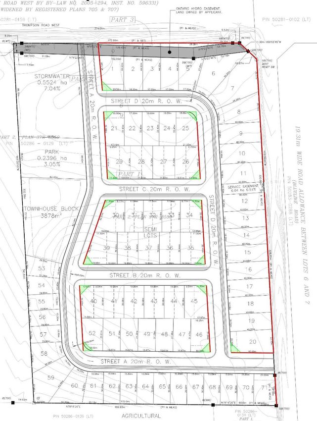
CD 21- 37                                                                     Page 5 of 12

Regard For Public Input:
Planning Staff received comments from the members of the community including
adjacent industrial properties - Norfolk Disposal and Lafarge Canada Inc. Key issues
and concerns identified in the submitted comments include:

   1. According to PPS, 2020 and Norfolk County Official Plan, the applicant must
      ensure land-use compatibility of the proposed new sensitive use with the existing
      and established industrial, waste management, and commercial uses in the
      immediate vicinity. The Planning Justification Report (G. Douglas Vallee Ltd,
      June 2020) submitted with the Applications, did not include a detailed policy
      analysis of the PPS Section 1.2.6.1 and a.2.6.2, and Norfolk County Official Plan
      policies section 7.12.2 e) and 7.12.2 f).
   2. The D6 Guideline generally recommends a minimum separation distance of 70m
      from the property lines of sensitive uses, such as a residence, to a Class II
      industrial use. In the case of the proposed residential development, the
      separation distance is only about 20m from the property line of the Lafarge
      Ready-Mix plant to the property line of the proposed residential.
   3. The D4 Guidelines should be included in the MOE D-series analysis for adjacent
      waste disposal activities.
   4. Noise Study should be updated with current traffic data
   5. No mitigation measures are provided with the proposal. Re-designing the Draft
      Plan of Subdivision with mitigation measures such as open-space and
      stormwater management facilities as additional setbacks distance and buffers
      from the adjacent industrial uses to the proposed residential uses should be
      considered.

Planning Considerations:

It is owner’s responsibility to be aware of and comply with all relevant federal or
provincial legislation, municipal by-laws or other agency approvals.

Provincial Policy Statement, 2020
The PPS provides policy direction on matters of provincial interest related to land use
planning and development. It promotes efficient development and land use patterns and
encourages growth and development within existing settlement areas. The subject land
is within the ‘settlement area’ as defined in the Provincial Policy Statement.
Section 1.1.3 states that settlement areas are urban areas and rural settlement areas,
and include cities, towns, villages and hamlets. This section also mentioned that land-
use patterns within settlement areas (including urban areas) shall be based on densities
and a mix of land uses with certain characteristics, including efficient land use,
infrastructure and service facilities. Section 1.1.3.4 related to settlement areas, states
that appropriate development standards should be promoted which facilitate
intensification, redevelopment and compact form, while avoiding or mitigating risks to
public health and safety.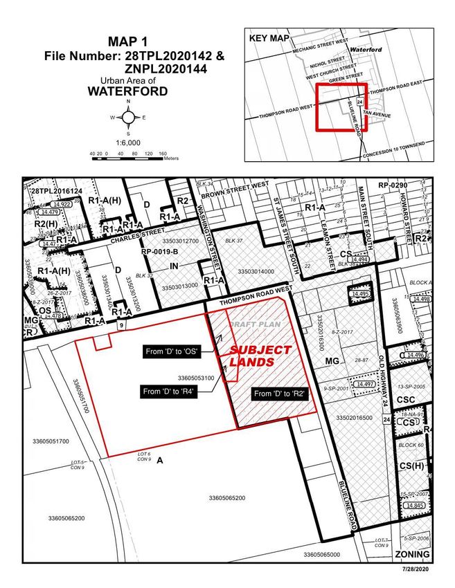
CD 21- 37 Page 6 of 12
Section 1.2.6.1 related to Land Use Compatibility states that major facilities and
sensitive land uses shall be planned and developed to avoid, or if avoidance is not
possible, minimize and mitigate any potential adverse effects from odour, noise and
other contaminants, minimize risk to public health and safety, and to ensure the long-
term operational and economic viability of major facilities in accordance with provincial
guidelines, standards and procedures.
Section 1.2.6.2 states that Where avoidance is not possible in accordance with policy
1.2.6.1, planning authorities shall protect the long-term viability of existing or planned
industrial, manufacturing or other uses that are vulnerable to encroachment by ensuring
that the planning and development of proposed adjacent sensitive land uses are only
permitted if the following are demonstrated in accordance with provincial guidelines,
standards and procedures:
there is an identified need for the proposed use;
alternative locations for the proposed use have been evaluated and there
are no reasonable alternative locations;
adverse effects to the proposed sensitive land use are minimized and mitigated;
and
potential impacts to industrial, manufacturing or other uses are minimized and
mitigated.
Section 1.6.6.2 related to Sewage, Water and Stormwater states that municipal sewage
services and municipal water services are the preferred form of servicing for settlement
areas to support protection of the environment and minimize potential risks to human
health and safety.
Planning Comments: Planning Staff will perform a conformity check based on the
above-mentioned policies of PPS, 2020 within the recommendation report.
Norfolk County Official Plan
The subject land is designated as ‘Urban Residential’ in the Official Plan. Section 6.4
related to urban areas states that the County shall ensure through its planning activities
that each Urban Area develops with efficient land use patterns that minimize the
extension of municipal services and infrastructure.
Section 7.7 related to ‘Urban Residential’ designation states that for low profile
residential development such as Single, semi-detached and duplex housing forms shall
generally have an average net density of 15 units per hectare (UPH). Townhouses, and
other medium density housing forms, shall generally have a net density of between 15
and 30 UPH.
Section 9.6.4 related to ‘Draft Plan of Subdivision’ approval states that applications for
approval of a draft plan of subdivision shall be considered on the basis of conforming to
certain criteria, including the application of community design policies, engineering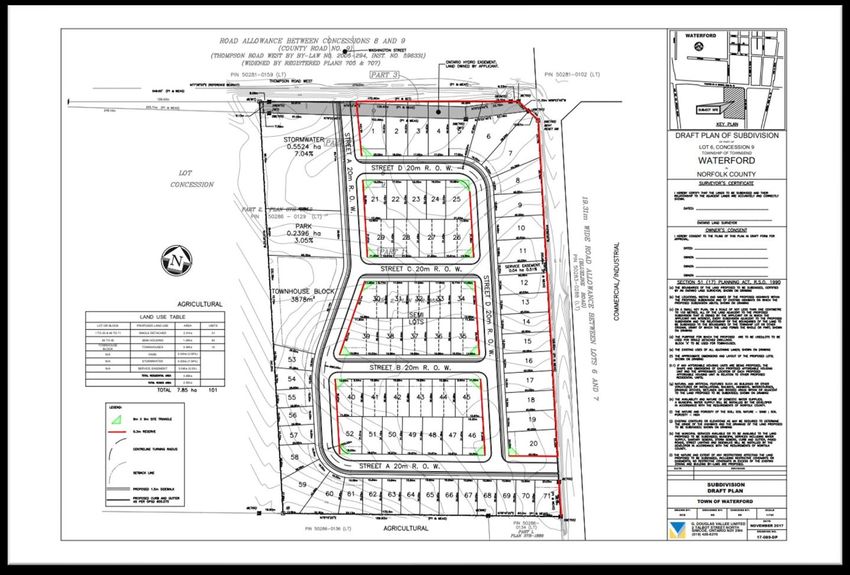
CD 21- 37                                                                      Page 7 of 12

standards, Parkland dedication, approval of the appropriate Conservation Authority,
province and other relevant agencies, and a subdivision agreement.

Section 5.4, related to ‘Community Design’ policies, provide direction to the physical
design of the communities for development proposals, such as plans of subdivision.

The adjacent properties at the north and east side of the subject land are designated as
‘Protected Industrial’ in the Official Plan. Section 7.12 related to protected industrial land
use policy states that in locating any sensitive land use in the vicinity of any established
or approved industrial use, the County shall establish appropriate separation distances
in consultation with the Ministry of the Environment and Climate Change and the
relevant guideline related to land use compatibility. Deviation from the established
separation distances shall require detailed supporting studies of the potential impacts
on the sensitive land use by the Industrial use, and vice-versa, and any recommended
mitigation measures.

Planning comments: The proposed development will be further reviewed based on the
above-mentioned policies. A conformity check of the Official Plan policies will be
provided within the recommendation report.

Norfolk County Zoning By-Law 1-Z-2014
The subject land is zoned as ‘Development (D)’ in the Zoning By-Law Z-1-2014.
Permitted use in ‘Development (D)’ zone includes single detached dwelling.

The Urban Residential Type 2 Zone (R2) is proposed for single and semi-detached
dwellings. The Urban Residential Type 4 Zone (R4) is proposed for street townhouses.

The proposed zoning changes include:

   1. From ‘Development (D)’ zone to 'Residential Type 2 (R2)' zone to permit 51
      single detached and 40 semi-detached residential dwelling units. Permitted uses
      in R2 zone are:
             a) dwelling, single detached
             b) dwelling, semi-detached
             c) dwelling, duplex
             d) bed & breakfast, subject to Subsection 3.4
             e) day care nursery
             f) home occupation
             g) accessory residential dwelling unit, subject to Subsection 3.2.3.

       Other provisions for semi-detached units include:

       a) minimum lot area:
              i) interior lot                                           255 sq.m.
              ii) corner lot                                            345 sq.m.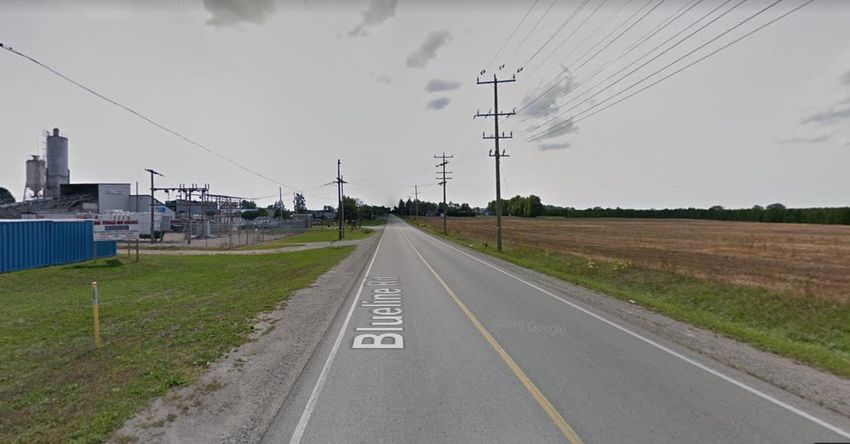
CD 21- 37                                                                     Page 8 of 12

       b) minimum Lot Frontage:
              i) interior lot                                         8.5 m
              ii) corner lot                                          11.5 m
       c) minimum front yard:                                         6m
              i) attached garage with rear lane                       3m
       d) minimum exterior side yard:                                 6m
       e) minimum interior side yard:
              i) detached garage                                      3m
              ii) detached garage with a rear lane; attached garage   1.2 m
       f) minimum rear yard:                                                  7.5 m
       g) maximum building height:                                            11 m

       The provisions in the R1-B Zone shall apply to single detached units.

   2. From ‘Development (D)’ zone to 'Residential Type 4 (R4)' zone to permit 10 block
      townhouse units. Permitted uses in R4 zone are:
            a) group townhouse
            b) stacked townhouse
            c) street townhouse
            d) semi-detached, duplex, tri-plex and four-plex dwellings provided they
            are
            located on the same lot with, and in accordance with the Zone provisions
            of, group townhouse
            e) home occupation.
            g) accessory residential dwelling unit, subject to Subsection 3.2.3.

       Other provisions for 'Residential Type 4 (R4)' include:

       a) minimum lot area:
              i) interior lot                                         156 sq.m.
              ii) corner lot                                          264 sq.m.
       b) minimum Lot Frontage:
              i) interior lot                                         6.5 m
              ii) corner lot                                          11 m
              iii) corner lot accessed by a rear lane                 6.5 m

       c) minimum front yard:                                        6m
              i) except in case of a detached private garage or parking
              space accessed via rear lane                           3m
       d) minimum exterior side yard:
              i) with a 6 metre front yard                           6m
              iI) with a 1.5 metre front yard                              1.5 m
       e) minimum interior side yard:                                1.5 m
       f) minimum rear yard:
              i) attached garage                                     7.5 m
              ii) detached garage(accessed by rear lane)                   13 m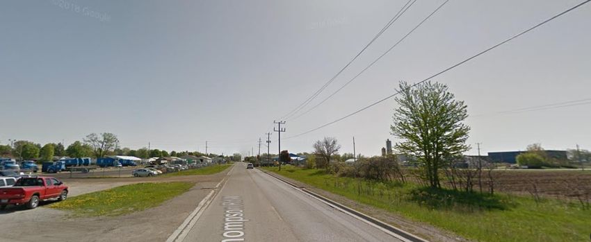
CD 21- 37                                                                   Page 9 of 12

       g) minimum separation:                                        2m
       h) maximum building height:                                          11 m

Special Provision for R2 and R4 zone: One special provision is requested to reduce the
exterior side yard from 6 meters to 3 meters.

The Storm Water and Park space are to be zoned as ‘Open Space (OS)’.

Planning Comments: The proposed zoning change will result in an increased density
of sensitive land use adjacent to the active protected industrial area. The zoning
changes will be further reviewed with all applicable provincial and municipal land-use
policies for compatibility assessment.

Strategic Plan Linkage:
This report aligns with the 2019-2022 Council Strategic Priority "Foster Vibrant, Creative
Communities".

Explanation: The proposed subdivision should facilitate and promote appropriate
growth and density within the neighbourhood.

Conclusion: The purpose of this report is to summarize the planning application
proposal, provide the comments received from applicable departments and agencies,
summarize comments received from member of the public, and to provide general
information in relation to the overall application. A staff report with related
recommendations will be submitted to Council for consideration at a later date.

Recommendation(s):
THAT Report CD 21-37, Public Hearing report for 28TPL2020142 and ZNPL2020144
be received for information;

THAT any outstanding technical comments and requirements necessary prior to
bringing forward a recommendation report be addressed;

AND THAT any comments received as part of the statutory public meeting be
considered in a future recommendation staff report.

Attachment(s):
Maps 1 to 2
Appendix A Circulation Comments
Appendix B Public Input
Appendix C Proposed Draft Plan of Subdivision
Appendix D Planning Justification Report
CD 21- 37                                                     Page 10 of 12

Submitted By:                        Reviewed By:
Brandon Sloan, BES, MCIP, RPP        Tricia Givens, M.Sc.(PL), MCIP, RPP
General Manager                      Director of Planning
Community Development Division       185 Robinson Street
185 Robinson Street                  Simcoe, Ontario, Canada, N3Y 5L6
Simcoe, Ontario, Canada, N3Y 5L6     519-426-5870 ext. 1893
519-426-5870 ext. 1348

Prepared By:
Mohammad Alam, MPL, MUD, MCIP, RPP
Senior Planner
Community Development Division
519-426-5870 x. 1828
CD 21- 37 Page 11 of 12
CD 21- 37 Page 12 of 12
APPENDIX A

Circulation Comments:

Financial Services

Reviewed – This application would have a positive impact on assessment growth and
tax revenues. The amount of growth is dependent on the assessment of the properties
by the Municipal Property Assessment Corporation (MPAC). Norfolk County would also
receive Development Charges as per the most recent Development Charges By-law.
This would be offset by increased costs as a result of Norfolk County assuming the
subdivision infrastructure, amenities and operating costs. Accounting Services will work
with Planning staff to administer the required security deposits of the potential
development.

Planning

Reviewed - Provide a colour coded map indicating the different types of zoning
classifications that are being applied for. In addition please provide a zoning table to
clearly indicate the zone and lot provisions.

The Storm Water and Park space is to be zoned Open Space (OS). This must be
reflected in the application.

Sight Triangles are provided within the draft plan of subdivision. Please provide sight
triangles at the entrances into the subdivision off of Thompson Road West and Blue
Line Road.

Provide turning radius lines at every turning location with dimensions.

For Cash in Lieu of parkland, it is listed at 3%. How is the remaining 2% going to be
provided?

Is phasing being proposed and if so can you indicated this on the draft plan of
subdivision? In addition a landscape drawing is to be submitted.

At the service easement, is it possible to provide a 3 metre wide concrete connection
onto Blue Line Road?

Building
Reviewed – No comments.
GIS
Reviewed - Please contact Norfolk GIS for new civic addresses and street names when
building.

Agreement Coordinator

Reviewed – Comments are as follows:
ZNPL2020144

Recommend that a Holding (H) Provision be added to the lands and remain in place
until either the pre-servicing agreement or the subdivision agreement has been
executed and registered on title.
28TPL2020142

I am excited to be working with you during the agreement stage of your subdivision until
the final release of your performance securities. To expedite the process please contact
me so I can provide you with a checklist for further information and user fees in order to
start your subdivision agreement.

The Owner will be required, at its expense, to obtain and keep in force, insurance
coverage until the securities have been released at the completion of your project. Your
surveyor, engineer and architect will also be required to provide insurance for
professional liability.
Recommended conditions will be prepared as part of the planning report. If it is
determined appropriate, a condition of the development of land, will be the requirement
for a cash-in-lieu parkland payment. This payment is determined from a land appraisal
(preconstruction) prepared for the Owner at its expense.
If there are any charges or mortgage holders on your property they will be required to
postpone their interest on the property to the County’s development agreement.

Zoning Administrator
Reviewed – Comments are as follows:
   1) Provide zoning table on site plan to ensure zoning is met for each zone, and any
      deficiencies are noted.
   2) Ensure parking bylaw is met for parking lot areas, visitor parking, and parking
      spaces inside the dwelling units. Refer to section 4.0 of the Norfolk county zoning
      bylaw.

Fire
Reviewed – No comments.
Parks and Recreation
Reviewed – 5% for parkland dedication is required, as stated in the pre-con meeting
Development Engineering
Reviewed: Comments are as follows:
ZNPL2020144:
Development Engineering has reviewed ZNPL2020144 and have no comments.
28TPL2020142:
I. General Comments:
1) Full Development Engineering comments will be provided after draft plan
approval.
2) The LPRCA must be consulted regarding the proposed development. Provide
confirmation from the LPRCA that the proposed outlet meets their
requirements.
3) Private utilities should be circulated on the proposed development plans prior
to draft plan approval. Please provide letters of understanding from private
utility companies including Hydro One regarding the existing hydro easement.
4) As per Norfolk County Design Criteria, as-constructed / record drawings
guidelines are to be adhered to. This has been attached for your reference.
Securities will be required for as-constructed / record drawings. Information
only.
5) The area of this development is not assessed in the Waterford South
Municipal Drain. There is no current storm water outlet that is sufficient for
this development. The Waterford South Municipal Drain report (John Vallee,
P.Eng., 1996) specifically notes the design excluded this area and it is not to
be connected. See excerpt from the report below. This subdivision cannot use
this drain and pond as an outlet.6) The Property is within the municipal drainage area of the “Waterford South”
Municipal Drain but has not been assessed or included within the current
report or system. If the development is granted to outlet to the WSMD, an
engineer must be hired to complete a re-evaluation of the original drain
system/report as per Section 76 of the Drainage Act.
7) The applicant covenants and agrees to pay all costs related to the
Corporation of Norfolk County hiring an engineer on behalf of the applicant as
per Section 4 (1) of the Drainage Act for the purpose of assessing capacities
of piping for the existing municipal drain or to construct an entirely new
municipal drainage system to service the property.
8) The West ½ of Blueline Road and South ½ of Thompson Road to be built to
Urban Standards, which includes curb, gutter and Sidewalks to south property
line and the west property line respectively from the intersection of Blueline
Road & Thompson Road.
II. Draft Plan of Subdivision Drawing (17-089-DP) G.Douglas Vallee:
1) Provide the existing road allowance width on Thompson Road West.
2) Visibility triangles must be shown at the intersection of Blueline Road and Street
‘A’ and Thompson Road West and Street ‘A’. The dimensions of the triangle must
be determined by a Professional Engineer with reference to Transportation
Association of Canada standards and specifications
3) Will the proposed service easement be registered as a separate block or
easement? Please clarify.
4) Show the full extent of the existing sanitary main on Blueline Road. See drawing
N-65.
III. Geotechnical Report:1. Pavement structure are to match what is recommended within the Geotechnical
Report.
2. All discussions and recommendations of the Geotechnical Report PML Ref:
17HF038 dated January 2018 must be adhered.
3. In the Geotechnical report there is identification of a sample having an elevated
reading of “Chromium VI”. Is any mitigation required for the elevated sample of
Chromium VI?
IV. Functional Servicing Report (F.S.R):
1) Any recommendations from the Sanitary / Water modelling reports will be included
as a draft plan condition.
2) Has there been any discussion / design for the extension of the proposed gravity
sanitary main from Prop. SANMH 5 and tying into the existing sanitary main on
Blueline Road? This option would eliminate the service easement.
3) The Norfolk County design Criteria Section 10.3.0 Watermains, states:
All watermains shall be looped. New subdivisions shall be designed in such a
manner that there are two separate watermain feed lines into the subdivision,
and shall be interconnected to existing watermains adjacent to the site in order to
promote overall water quality within the water distribution system.
Watermain is to be looped as per Norfolk County Criteria.
4) Is there any emergency overflow paths being proposed for the storm water
management facility? Please provide a brief detailed analysis of the proposed
emergency overflow path.
5) Provide a detailed analysis of the outlet storm sewer capacity.
6) Are there any existing external flows on the site that will need to be
accommodated? Is there Legal outlet for these flows?
Long Point Region Conservation Authority
Reviewed – Long Point Region Conservation Authority staff have reviewed the above-
noted application as part of the Draft Plan of Subdivision affecting the Thompson Road
Subdivision.
Delegated Responsibility from the Ministry of Natural Resources and Forestry, Section
3.1 of the Provincial Policy Statement, 2020
Conservation Authorities have been delegated responsibilities from the Minister of
Natural Resources and Forestry to represent the provincial interests regarding naturalhazards encompassed by Section 3.1 of the Provincial Policy Statement, 2020 (PPS).
The overall intent of Section 3.0 - Protecting Public Health and Safety of the PPS is to
reduce the potential public cost or risk to Ontario’s residents from natural or human-
made hazards.
The proposed development is located outside any area that is subject to natural
hazards as defined in the PPS. It is LPRCA staff’s opinion that the proposed
development is consistent with section 3.1 of the Provincial Policy Statement, 2020.
Stormwater Management
LPRCA technical staff have reviewed the technical information provided and have
provided the following comments.
1. The functional service report must comment on the ability of the wet pond to
provide sufficient water quantity and water quality control.
2. Sizing information for the minor flow system routes must be provided.
3. An erosion and sediment control plan must be provided.
Ontario Regulation 178/06
No portion of the subject lands is regulated under Ontario Regulation 178/06.
Amtelecom Communications
Reviewed – No Comments.
Hydro One
Reviewed – No Comments.
East Link
Reviewed – No Comments.APPENDIX B
WATERFORD

                                                                  DRAFT PLAN OF SUBDIVISION
                                                                                            OF PART OF

                                                                                 LOT 6, CONCESSION 9
                                                                                  TOWNSHIP OF TOWNSEND

                                                                                 WATERFORD
                                                                                                  IN

                                                                                NORFOLK COUNTY

                      LAND USE TABLE
 LOT OR BLOCK        PROPOSED LAND USE       AREA         UNITS

1 TO 25 & 46 TO 71    SINGLE DETACHED       3.31ha         51

    26 TO 45           SEMI HOUSING         1.28ha         40
  TOWNHOUSE
                       TOWNHOUSES           0.39ha         10
    BLOCK
       N/A                 PARK          0.24ha (3.05%)

       N/A             STORMWATER        0.55ha (7.04%)

       N/A           SERVICE EASEMENT    0.04ha (0.5%)

                                            4.98ha

                                            2.05ha

                                                                  DATE                                 REVISION

                                                                                     SUBDIVISION
                                                                                     DRAFT PLAN

                                                                                TOWN OF WATERFORD
                                                                  DRAWN BY:        DESIGNED BY:        CHECKED BY:         SCALE
                                                                    DCB                ED                  ED              1:750

                                                                                                                          DATE
                                                                              G. DOUGLAS VALLEE LIMITED              NOVEMBER 2017
                                                                              2 TALBOT STREET NORTH
                                                                              SIMCOE, ONTARIO N3Y 3W4                  DRAWING NO.
                                                                              (519) 426-6270
                                                                                                                       17-089-DP
June 15, 2020
County of Norfolk
Robinson Administration Building
185 Robinson Street, Suite 200
Simcoe, ON N3Y 5L6
Attention: Tricia Givens, M.Sc.(Pl), MCIP, RPP
Reference: Planning Justification Report
Application for Draft Plan of Subdivision/Zoning By-law
Amendment I-Z-2014
G. Douglas Vallee Limited on behalf of Dixon Homes Inc.
Thompson Subdivision, Waterford, Norfolk County
Our Project 17-089
Introduction:
G. Douglas Vallee Limited has been retained by Dixon Homes Inc. to make application for
approval of a draft plan of subdivision and a Zoning By-law Amendment to permit approximately
101 residential dwelling units in Waterford, Norfolk County. It is proposed to rezone the subject
lands from Development Zone (D) to Urban Residential Type 2 Zone (R2) and Urban Residential
Type 4 Zone (R4) with special exceptions to implement the draft plan of subdivision in the form
of single detached, semi-detached and street townhouse dwelling units respectively. To improve
the character of the proposed subdivision, a reduction to the exterior side yard setback on corner
lots from 6 metres to 3 metres is requested.
These applications:
• Comply with the Norfolk County Official Plan.
• Are consistent with the intent of the Provincial Policy Statement 2020.
• Comply with the intent of Section 51(24) of the Planning Act.
• Achieve compatibility with the surrounding commercial and industrial land uses as
demonstrated by the Ministry D-Series Guidelines study and Land Use Compatibility
study submitted in support of this development.
• Provide a mix of housing types and appeals to a variety of household income levels.
• Generate an acceptable level of traffic.
• Utilize existing infrastructure and do not create adverse affects on the County water and
sanitary sewer systems.
• Represent good planning.
2 Talbot Street North, Simcoe, ON N3Y 3W4 Phone: 519 426-6270 Fax: 519 426-6277 www.gdvallee.ca
G. Douglas Vallee LimitedThompson Draft Plan of Subdivision and Zoning By-law Amendment
Waterford, Norfolk County
Our Project 17-089 Page 2
Purpose:
The purpose of this Planning Justification Report is to provide planning support and information
to the County to consider when reviewing the proposed application for a draft plan of subdivision
and zoning by-law amendment.
Site Description:
The lands are located in Waterford within the urban boundary and lie to the west of Blue Line
Road and south of Thompson Road West. The topography represents a gradual slope of
approximately 2 metres from the highest elevations from the northerly and southerly property
lines towards the centre of the property.
Figure 1: Location of Subject Lands in Waterford
G. DOUGLAS VALLEE LIMITED
Consulting Engineers, Architects & Planners
Authorized by the Association of Professional Engineers of Ontario
to offer professional engineering services.Thompson Draft Plan of Subdivision and Zoning By-law Amendment
Waterford, Norfolk County
Our Project 17-089 Page 3
Figure 2: Proposed Draft Plan of Subdivision
Concept
Surrounding and Existing Land Uses
The lands abutting to the east are comprised of various uses including Norfolk Disposal Services
Limited, Lafarge Concrete and a Car Wash and Pet Grooming business. The lands to the north,
across Thompson Road West, is a second location for Norfolk Disposal Services Limited. Active
cash crop farming is located to the west. The lands to the south are currently used as a cash
crop farming operation where a portion of the lands closest to Blue Line Road are intended for
residential purposes. The subject lands are currently vacant having been farmed over the years.
Background:
The proposed development lands were severed from the larger agricultural farm holding to
facilitate the application for a draft plan of subdivision and zoning by-law amendment. Supporting
information has been prepared and submitted with these applications including:
G. DOUGLAS VALLEE LIMITED
Consulting Engineers, Architects & Planners
Authorized by the Association of Professional Engineers of Ontario
to offer professional engineering services.Thompson Draft Plan of Subdivision and Zoning By-law Amendment
Waterford, Norfolk County
Our Project 17-089 Page 4
• Noise Impact Assessment (prepared by Rubidium Environmental dated October 25,
2019)
• Ministry of Environment D-Series and compatibility study (prepared by Rubidium
Environmental dated October 28, 2019)
• Traffic Impact Study (prepared by RC Spencer Associates Inc. dated March, 2020)
• Geotechnical Investigation and Limited Chemical Testing Program (prepared by Peto
MacCallum Ltd. (PML) dated January 22, 2018)
• Functional Servicing Report (prepared by G. Douglas Vallee Limited dated May 12, 2020.)
Appendices to this report include the following:
Appendix A - Pre-consultation meeting comments
Appendix B – Draft Plan of Subdivision
Appendix C – Provincial Policy Statement 2020 Policy Compliance
Appendix D – Norfolk County Official Plan Policy Compliance
Appendix E – Section 54(24) of the Planning Act
This application was submitted to include the information and material required under Section
34 (10.1) and 51 (16) of the Planning Act as part of a complete application.
Proposal:
It is proposed that the draft plan of subdivision containing approximately 101 residential dwelling
units, a stormwater management pond, visitor parking and an internal network of roads and
sidewalks, be approved. The draft plan being considered proposes 51 single detached dwelling
units, 40 semi-detached dwelling units and 10 street townhouse dwelling units.
The lands are designated as Urban Residential in the Norfolk County Official Plan. The lands
are zoned Development Zone (D) in accordance with Comprehensive Zoning By-law No. I-Z-
2014.
It is proposed to rezone the subject lands from Development Zone (D) to Urban Residential Type
2 Zone (R2) and Urban Residential Type 4 Zone (R4) with special exceptions to implement the
draft plan of subdivision.
To improve the character of the draft plan of subdivision, the special exceptions being requested
for corner lots are:
• Urban Residential Type 2 Zone (R2) - Reduction of the exterior side yard setback from 6
metres to 3 metres; and
• Urban Residential Type 4 Zone (R4) – Reduction of the exterior side yard setback from 6
metres to 3 metres.
G. DOUGLAS VALLEE LIMITED
Consulting Engineers, Architects & Planners
Authorized by the Association of Professional Engineers of Ontario
to offer professional engineering services.Thompson Draft Plan of Subdivision and Zoning By-law Amendment
Waterford, Norfolk County
Our Project 17-089 Page 5
Planning Documents:
The proposed zoning by-law amendment was prepared in light of several planning documents
including the Planning Act, the Provincial Policy Statement, the County Official Plan and
Zoning By-law.
Planning Act
Section 2 of the Planning Act outlines matters of provincial interest.
Section 3 of the Planning Act requires that, in exercising any authority that affects a planning
matter, planning authorities “shall be consistent with the policy statements” issued under the Act
and “shall conform with the provincial plans that are in effect on that date, or shall not conflict
with them, as the case may be”.
Section 34 of the Planning Act allows for the consideration of amendments to the zoning by-law.
Section 51 of the Planning Act outlines the requirements for considering a draft plan of
subdivision.
Provincial Policy Statement (2020)
The subject land is identified as being within a Settlement Area according to the Provincial Policy
Statement, 2020 (PPS).
The PPS provides policy direction for appropriate land use planning and development patterns
to achieve healthy, liveable, and resilient communities that will protect resources of provincial
interest, public health and safety, the quality of the natural and built environment, and will
facilitate economic growth.
A decision by Council to approve the Zoning By-law amendment and draft plan of subdivision
will be consistent with PPS, 2020. Details describing the applicable Provincial policies and how
the application is consistent with the PPS are included in Appendix C.
Norfolk County Official Plan
The lands are designated Urban Residential in accordance with the Official Plan. The proposal
to develop approximately 101 residential dwelling units meets the criteria of the Official Plan as
demonstrated in Appendix D.
Several sections of the Official Plan apply when considering draft plan of subdivisions and zoning
by-law amendments and are discussed in detail under Appendix D. On a high level, details of
the Official Plan policies are captured by the overarching Goals and Objectives. Section 2.2 of
G. DOUGLAS VALLEE LIMITED
Consulting Engineers, Architects & Planners
Authorized by the Association of Professional Engineers of Ontario
to offer professional engineering services.Thompson Draft Plan of Subdivision and Zoning By-law Amendment
Waterford, Norfolk County
Our Project 17-089 Page 6
the Official Plan set out six “Goals and Objectives” to which the following four are applicable to
the proposed residential development:
• Maintaining and Enhancing the Rural and Small-Town Character;
• Maintaining a High Quality of Life;
• Upgrading and Expanding Infrastructure; and
• A Well Governed, Well Planned and Sustainable County.
The proposed draft plan of subdivision and zoning by-law amendment achieve the ‘Goals and
Objectives’ of the Official Plan. The plan of subdivision is designed with massing, provision of
housing choices and character at the forefront, ensuring a compact form, contributing to an
appropriate mix of land uses and densities in the neighbourhood. This will result in an efficient
use of land of high quality providing a variety of housing forms and a level of affordability.
The draft plan of subdivision achieves a desirable road pattern, provides parkland, facilitates a
walkable neighbourhood, incorporates design elements for pedestrian safety (Crime Prevention
Through Environmental Design - CPTED) by ensuring public spaces are visible and well lit. An
internal network of sidewalks will be provided throughout the neighbourhood to facilitate a safe
and aesthetically appropriate development. The stormwater management pond is located
adjacent to the parkland to create a large open space effect. Public transit is within a five (5)
minute walk from the nearest street access and within ten (10) minutes of the furthest dwelling
in the subdivision.
Norfolk County’s existing infrastructure (road, sewers, watermains, treatment plants etc.) are
capable of supporting this development. The development makes good and efficient use of this
existing infrastructure. The proposed infrastructure will be designed and constructed in
accordance with Norfolk County’s requirements, and will be subject to Norfolk County’s approval.
The lands are near existing residential, commercial and institutional uses including the Saint
Bernard Claurveux Catholic School, the Waterford District Highschool and the Waterford Public
School. The Rubidum Environmental report demonstrates compatibility between existing and
proposed industrial uses in the area by providing either warning clauses or the construction of a
barrier fence.
Summary of Official Plan review
The proposed draft plan of subdivision and zoning by-law amendment meets the policies of the
Official Plan. County comments related to back-lotting, berming, landscaping and connecting
roads have been addressed. The development concept represents the most appropriate design
considering County comments, and the results of supporting studies (i.e. Rubidium – Noise
Impact Assessment). Accordingly, the proposed applications meet the intent and purpose of the
Official Plan and represent good planning.
G. DOUGLAS VALLEE LIMITED
Consulting Engineers, Architects & Planners
Authorized by the Association of Professional Engineers of Ontario
to offer professional engineering services.Thompson Draft Plan of Subdivision and Zoning By-law Amendment
Waterford, Norfolk County
Our Project 17-089 Page 7
Norfolk County Comprehensive Zoning By-law 1-Z-2018
The lands are currently zoned Development D Zone. The Urban Residential Type 2 Zone (R2)
is proposed for single and semi-detached dwellings. The Urban Residential Type 4 Zone (R4)
is proposed for street townhouses.
Accessory residential dwelling units are permitted with single and semi-detached dwellings and
with street townhouses subject to section 3.2.3 of the zoning by-law.
The proposed lots/blocks comply with the R2 and R4 Zone provisions with minor requests for
modifications as follows:
Zoning Table for Urban Residential Type 2 Zone
Notes:
Section 5.2 (R2)
5.2.1 PERMITTED USES
a) Single-detached dwelling Other uses are permitted in
(subject to the R1-B Zone) R2 Zone, but only Single’s
b) Semi-detached dwelling. and Semi’s are proposed.
5.2.2 ZONE PROVISIONS FOR SINGLE AND SEMI-DETACHED DWELLINGS
Minimum Lot Area
Single(R1B) Semi (Per Unit)
Complies
i) Interior 360m2 255m2
ii) Corner 450m2 345m2
Minimum Lot Frontage
Single(R1B) Semi (Per Unit)
12m 8.5m Complies
i) Interior
15m 11.5m
ii) Corner
c) Front Yard Setback 6m Complies
Proposed reduction to
d) Exterior Side Setback 6m
3.0m
e) Interior Side Yard
1.2m for attached garage Complies
Setback
f) Rear Yard Setback 7.5m Complies
g) Maximum Building
11m Complies
Height
4.9 Parking Space Requirements for Residential Uses
Single and Semi- 2 spaces per unit
Complies
Detached Dwelling
G. DOUGLAS VALLEE LIMITED
Consulting Engineers, Architects & Planners
Authorized by the Association of Professional Engineers of Ontario
to offer professional engineering services.Thompson Draft Plan of Subdivision and Zoning By-law Amendment
Waterford, Norfolk County
Our Project 17-089 Page 8
Zoning Table for
Urban Residential Type 4 Zone
Notes:
(R4)
Section 5.4
5.4.2 PERMITTED USES
Other uses are permitted
Street Townhouse
in R4 Zone, but only Street
Townhouses are proposed
5.4.2 ZONE PROVISIONS FOR STREET TOWNHOUSE DWELLINGS
Minimum Lot Area
i) Interior 156m2 Complies
264m 2
ii) Corner
Minimum Lot Frontage
i) Interior 6.5m Complies
ii) Corner 11m
c) Front Yard Setback 6m Complies
Proposed reduction to
d) Exterior Side Setback 6m
3.0m
e) Interior Side Yard
1.2m Complies
Setback
f) Rear Yard Setback 7.5m Complies
g) Min separation
between townhouse 2m Compiles
dwellings
h) Maximum Building
11m Complies
Height
4.9 Parking Space Requirements for Residential Uses
Street Townhouse 2 spaces per unit
Complies
Dwelling
Noise Barrier Fence Proposed to be approximately 2 Required from Rubidium
metres in height. report.
Summary of Zoning By-law review
The proposed reduction to the exterior side yards encourages dwellings to be located closer to
the street, is a good urban design feature and increases the efficient use of lands. This same
special exemption has been routinely and successfully applied to other subdivisions in Norfolk
County. It is suggested that the County give strong consideration to amending the parent zoning
by-law so that this exemption is incorporated into the standard provisions for residential zones
within Norfolk County. The development will meet all other zone provisions of the County’s
Zoning By-law.
G. DOUGLAS VALLEE LIMITED
Consulting Engineers, Architects & Planners
Authorized by the Association of Professional Engineers of Ontario
to offer professional engineering services.Thompson Draft Plan of Subdivision and Zoning By-law Amendment
Waterford, Norfolk County
Our Project 17-089 Page 9
The proposal to develop a mix of approximately 101 single, semi-detached and street townhouse
units with the above noted site specific provisions to the R2, (R1-B through R2 Zone) and R4
Zone categories contribute to a well-planned and designed plan of subdivision and represent an
efficient use of lands that caters to various housing and social needs.
Design:
The design of the proposed subdivision is suitable for the location having street frontage on Blue
Line Road and Thompson Road West. The following represent a number of design
considerations by both the applicant’s design team and County staff.
1. The location of the park and stormwater management facility are appropriate as they are
highly visible with extended frontage on roadways. Cash-in-lieu of parkland is proposed
for the 1.95% deficiency in parkland area. This cash payment will be based on an
appraisal of the lands where the equivalent value of 1.95% of the value of the subject
lands (prior to approvals) is paid to the County. It is suggested that this cash payment be
used to equip the proposed parkland area to serve the future needs of the community.
2. The internal design of the road network is appropriate with two connections to existing
streets and no dead-ends or cul-de-sacs.
3. Back-lotting of lots along Blue Line Road and Thompson Road are necessary to avoid the
installation of many driveways along these busier roads. This will improve the safety of
those future owners entering and existing their driveways as well as avoiding traffic
travelling at higher speeds along these roads. In consideration of this design, additional
landscape treatments are proposed along the roadways to improve visual characteristics
along each road.
4. A future road connection to the west of the subject property is not proposed as the
adjacent lands are outside of the urban area. If the lands to the west are ever included in
the urban area, they are large enough to provide multiple accesses onto Thompson Road
West.
5. There is an appropriate mix of dwelling types in the form of single detached, semi-
detached and street townhouse dwellings.
6. The existing zoning by-law includes provisions for accessory residential dwelling units.
Zoning By-law provisions must be met during house design in order to permit accessory
residential dwelling units.
7. The proposed setbacks are consistent with the existing provisions of the zoning by-law
with the exception of the exterior side yards which are proposed to be reduced from 6
metres to 3 metres.
8. A cedar (or pressure treated) noise barrier fence is to be provided along the rear property
line of all lots backing onto Thompson Road West. The fence will be 2 metres high
consisting of closed board construction in accordance with the Rubidium report. The
provision of a berm/cedar tree planting strip was explored in replace of a noise barrier
fence. The density of the cedar tree strip would not be sufficient to mitigate noise impacts
generated from Thompson Road West.
G. DOUGLAS VALLEE LIMITED
Consulting Engineers, Architects & Planners
Authorized by the Association of Professional Engineers of Ontario
to offer professional engineering services.Thompson Draft Plan of Subdivision and Zoning By-law Amendment
Waterford, Norfolk County
Our Project 17-089 Page 10
9. The proposed park is less than a 5-minute walk from every lot within the draft plan of
subdivision.
10. Sidewalks are proposed on one side of all internal roadways.
Section 51(24) of the Planning Act:
There are several criteria under the Planning Act that must be considered when designing and
reviewing a draft plan of subdivision. The detailed list of criteria can be found in Appendix E of
this report. It is our opinion that the proposed plan of subdivision has successfully considered
the criteria of Section 51(24) of the Planning Act.
Conclusion:
The proposed Zoning By-law Amendment and Draft Plan of Subdivision implement the policies
of the PPS, the Norfolk County Official Plan and Section 51(24) of the Planning Act. Accordingly,
it is our opinion that the applications model good planning and implement an aesthetically
pleasing design that ensures efficiency and compatibility with the surrounding land uses.
Yours truly,
Eldon Darbyson
Eldon Darbyson, BES, MCIP, RPP
Director of Planning
G. DOUGLAS VALLEE LIMITED
Consulting Engineers, Architects & Planners
H:\Projects\2017\17-089 Thompson Farm (Dixon)\Agency\PJR\Final Rec Report - Thompson Subdivision - May 11, 2020.docxx
G. DOUGLAS VALLEE LIMITED
Consulting Engineers, Architects & Planners
Authorized by the Association of Professional Engineers of Ontario
to offer professional engineering services.You can also read