Appendix 13.4 Flood Risk Assessment - indaver ringaskiddy ...
←
→
Page content transcription
If your browser does not render page correctly, please read the page content below

Indaver                                                                   Ringaskiddy Resource Recovery Centre
                                                                                Environmental Impact Statement

                                                          Appendix 13.4
                                                          Flood Risk Assessment

EIS Volume 4 Appendices | Issue 1 | January 2016 | Arup                                     Appendix 13.4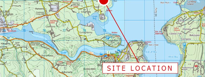
Indaver
                                                  Ringaskiddy Resource Recovery
                                                  Centre
                                                  Flood Risk Assessment
                                                  238129_REP/1_FRA

                                                  Issue 1 | 18 December 2015

This report takes into account the particular
instructions and requirements of our client.
It is not intended for and should not be relied
upon by any third party and no responsibility
is undertaken to any third party.

Job number         238129-00

Ove Arup & Partners Ireland

Arup
15 Oliver Plunkett Street
Cork
Ireland
www.arup.com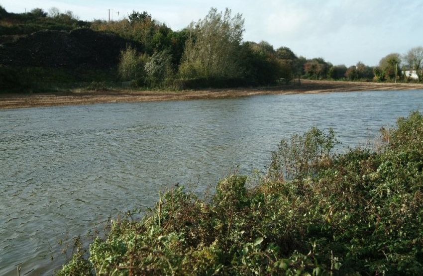
Document Verification

Job title                                       Ringaskiddy Resource Recovery Centre                                                        Job number
                                                                                                                                            238129-00
Document title                                  Flood Risk Assessment                                                                       File reference

Document ref                                    238129_REP/1_FRA
Revision                  Date                  Filename                    Indaver DRAFT FRA - 141013.docx
Draft 1                   10 Oct                Description First draft
                          2014

                                                                            Prepared by                                   Checked by           Approved by
                                                Name                        Kevin Barry                                   Ken Leahy            Ken Leahy

                                                Signature

Draft 2                   29 Oct                                            238129-00-2015-10-29_Flood Risk Assessment_ DRAFT
                                                Filename
                          2015                                              1.docx
                                                Description                 Revised draft based on updated site drawings

                                                                            Prepared by                                   Checked by           Approved by
                                                Name                        Kevin Barry                                   Fiona Patterson      Wolfram Schluter

                                                Signature

Draft 3                   12 Nov                Filename                    238129-00_FRA_Draft 3.docx
                          2015                  Description                 Draft 3

                                                                            Prepared by                                   Checked by           Approved by
                                                Name                        Kevin Barry                                   Fiona Patterson      Wolfram Schluter
                                                Signature

Issue 1                   18 Dec                Filename                    238129-00_FRA_Issue 1_20151217.docx
                          2015                  Description

                                                                            Prepared by                                   Checked by           Approved by
                                                Name                        Kevin Barry                                   Kevin Barry          Ken Leahy
                                                Signature

                                                                                             Issue Document Verification with Document

238129_REP/1_FRA | Issue 1 | 18 December 2015 | Arup
\\GLOBAL\EUROPE\CORK\JOBS\238000\238129-00\4. INTERNAL\4-04 REPORTS\4-04-03 INFRASTRUCTURE\FRA\238129-00_FRA_ISSUE 1_20151218.DOCX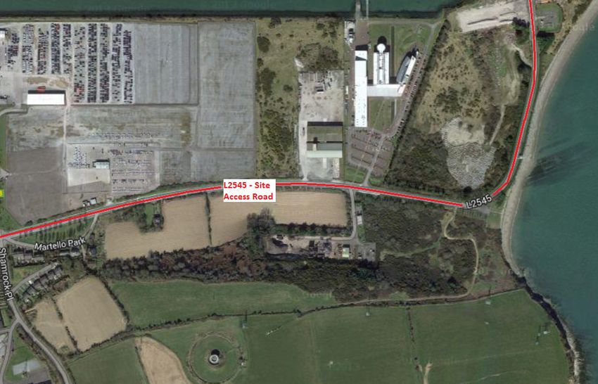
Indaver                                                                                                                         Ringaskiddy Resource Recovery Centre
                                                                                                                                               Flood Risk Assessment

Contents

                                                                                                                                                             Page
                  Executive Summary                                                                                                                             1

                  Introduction and background                                                                                                                   3
                  1.1                   Project background                                                                                                      3
                  1.2                   Scope of study                                                                                                          3
                  1.3                   Summary of data used and assumptions made                                                                               3
                  1.4                   Site description and proposed development                                                                               4

                  Planning context                                                                                                                              8
                  2.1                   The planning system and flood risk management guidelines 8
                  2.2                   The Cork County Development Plan 2014 - 2020                 9
                  2.3                   The Carrigaline electoral area local area plan 2011 (second
                                        edition January 2015)                                       12

                  Overview of flood hazard and historic flooding                                                                                              15
                  3.1                   Overview                                                                                                              15
                  3.2                   Historic flooding of the site and access road                                                                         15

                  Tidal flood risk                                                                                                                            20
                  4.1                   Lee CFRAM study                                                                                                       20
                  4.2                   Irish Coastal Protection Strategy Study (2011)                                                                        22
                  4.3                   Previous Arup studies                                                                                                 25

                  Other potential sources of flooding                                                                                                         28
                  5.1                   Fluvial risk                                                                                                          28
                  5.2                   Pluvial risk to the site                                                                                              28
                  5.3                   Pluvial risk to the road                                                                                              28
                  5.4                   Groundwater risk                                                                                                      29

                  Establishment of design flood levels                                                                                                        32
                  6.1                   Predicted 1 in 200 year design tidal level at subject site                                                            32
                  6.2                   Climate change                                                                                                        32
                  6.3                   Freeboard                                                                                                             33
                  6.4                   Proposed minimum site flood defence level                                                                             33
                  6.5                   More conservative site flood defence levels                                                                           33
                  6.6                   Proposed flood defence level for the L2545 road                                                                       34

                  Management of flood risk at the site                                                                                                        35
                  7.1                   Increase in ground levels above 1 in 200 year design tidal
                                        level                                                                                                                 35
                  7.2                   Floor levels of the buildings                                                                                         35

238129_REP/1_FRA | Issue 1 | 18 December 2015 | Arup
\\GLOBAL\EUROPE\CORK\JOBS\238000\238129-00\4. INTERNAL\4-04 REPORTS\4-04-03 INFRASTRUCTURE\FRA\238129-00_FRA_ISSUE 1_20151218.DOCX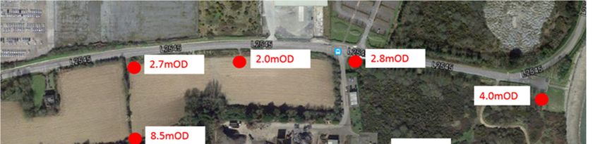
Indaver                                                                                                                         Ringaskiddy Resource Recovery Centre
                                                                                                                                               Flood Risk Assessment

                  7.3                   Roads and car parks                                                                                                   35
                  7.4                   Access and egress routes to the site                                                                                  35
                  7.5                   Proposed upgrade of the L2545                                                                                         36
                  7.6                   Proposed surface water drainage along the L2545                                                                       37
                  7.7                   Coastal protection study                                                                                              38

                  Application of ‘Flood Risk Management Guidelines’                                                                                           39
                  8.1                   Vulnerability classification                                                                                          39
                  8.2                   Flood zones                                                                                                           40
                  8.3                   Sequential approach                                                                                                   40

                  Conclusions                                                                                                                                 41

Appendices
No table of contents entries found.

238129_REP/1_FRA | Issue 1 | 18 December 2015 | Arup
\\GLOBAL\EUROPE\CORK\JOBS\238000\238129-00\4. INTERNAL\4-04 REPORTS\4-04-03 INFRASTRUCTURE\FRA\238129-00_FRA_ISSUE 1_20151218.DOCX
Indaver                                                       Ringaskiddy Resource Recovery Centre
                                                                             Flood Risk Assessment

Executive Summary
Indaver proposes to develop a resource recovery centre in Ringaskiddy in County
Cork. The proposed development will include a waste-to-energy facility for the
treatment of up to 240,000 tonnes per annum of residual household, commercial
and industrial non-hazardous and hazardous waste. Of the 240,000 tonnes of
waste, up to 24,000 tonnes per annum of suitable hazardous waste will be treated
at the facility.
In addition to the provision of the waste-to-energy facility, the proposed
development will include an upgrade of a section of the L2545 road, a connection
to the national electrical grid, an increase in ground levels in part of the site,
coastal protection measures above the foreshore on Gobby beach and an amenity
walkway to the Ringaskiddy Martello tower
A flood risk assessment is required as part of the planning application of the
project. This report details the flood risk assessment carried out by Arup. It has
been undertaken in accordance with the Guidelines for Planning Authorities on
‘The Planning System and Flood Risk Management’ published in November
2009, jointly by the Office of Public Works (OPW) and the then Department of
Environment, Heritage and Local Government (DEHLG).
The site for the Ringaskiddy Resource Recovery Centre is located approximately
15km to the south-east of Cork City, in the townland of Ringaskiddy on the
Ringaskiddy Peninsula in the lower part of Cork harbour. The site occupies an
area of approximately 13.55 hectares and is approximately 800m east of the
village of Ringaskiddy. The L2545, the main road from Ringaskiddy village to
Haulbowline Island forms the northern boundary of the site. The eastern boundary
of the site extends to the foreshore of Cork harbour along Gobby Beach. The lands
to the immediate south and west are in agricultural use. The site surrounds the
Hammond Lane Metal Recycling Co Ltd facility.
In broad terms, the potential sources of flooding to the site at Ringaskiddy can be
categorised as follows Tidal/Coastal Flooding, Pluvial Flooding, Groundwater
Flooding and Urban Drainage. Given the site’s proximity to Cork Harbour, the
main source of potential flooding at the site is tidal.
Given the absence of any significant watercourse from the site the risk of fluvial
flooding is remote.
Based on a review of all available information, the predicted 1 in 200 year design
tidal level for the site and adjacent L2545 has been estimated as 2.73m OD.
Sections of the road close to the Gobby beach car park are below this level and are
therefore at risk of tidal flooding during a 1 in 200 year tidal event.
There is a risk of pluvial flooding to the L2545 and the low lying areas of the site
during periods of heavy rainfall due to an insufficient drainage network and tide
locking of the existing drainage outfall.
Small areas of the site along the northern boundary are also below the predicted 1
in 200 year design tidal level (2.73m OD). The majority of the site is above 2.73m
OD.
There is a low risk of groundwater flooding of the site.

238129_REP/1_FRA | Issue 1 | 18 December 2015 | Arup                                  Page A1
238129-00_FRA_ISSUE 1_20151218.DOCX
Indaver                                                        Ringaskiddy Resource Recovery Centre
                                                                              Flood Risk Assessment

The subject site is not indicated as being within the design 1000 year tidal
floodplain. Consequently the site is classified as lying within Flood Zone C.
The minimum design flood defence level of the proposed development has been
calculated as 3.8m OD Malin. Arup however has proposed a far more
conservative flood defence level of 4.55m OD Malin for the site. This level offers
a very high standard of flood protection to the site.
It is proposed to raise the footprint of the entire site to the proposed site flood
defence level of 4.55m OD. This includes all internal roads, car parking area and
all associated site works. This measure will ensure that the risk of flooding to the
site is remote. The finished floor level of the buildings on the site will be set at
even more conservative levels – the administration building and ESB substation
will be set at 5.0m OD Malin while the floor level of the main process building
varies from 5.0m to 7.0m OD Malin. The Turbine and Aero-Condenser buildings
will be set at 11m OD Malin.
It is proposed to upgrade the L2545 to address the risk of flooding of the road.
The upgrade works will include raising a 185m section of the road to a maximum
height of 3.45m OD between the car park adjacent to Gobby Beach and the
eastern end of the Hammond Lane Metal Company site. This is approximately
1.0m above the existing road level. This will elevate the road to above the 200
year design tidal water level plus an allowance for climate change. This will offer
a high level of protection to the road from tidal flooding and ensure that access
and egress routes are maintained during extreme flood events.
A new dedicated surface water drainage system will also be installed as part of the
upgrade works to collect, convey and attenuate the runoff from the road before
connecting back into the existing drainage to discharge to the foreshore.
These measures are sufficient to ensure that the risk of flooding of the site and the
L2545 is extremely low.
It is considered that the proposed resource recovery centre at Ringaskiddy should
be classified as a “Highly Vulnerable Development” as per the vulnerability
classification. As the site is classified as Flood Zone C, a Justification Test is not
required for the proposed development and it is necessary only to identify
mitigation measures for any residual risks.
A wave modelling and erosion study of the area of the subject site was undertaken
by Arup in 2015 and is detailed in the Coastal Erosion Report submitted as part of
this planning application.
Based on the results from the modelling and the protected location of the site it
was concluded that wave conditions in the nearshore area are sufficiently low to
potentially allow for the use of an appropriate ‘soft’ coastal solution to protect the
toe and base of the glacial till cliffs from wave action.

238129_REP/1_FRA | Issue 1 | 18 December 2015 | Arup                                   Page A2
238129-00_FRA_ISSUE 1_20151218.DOCX
Indaver                                                         Ringaskiddy Resource Recovery Centre
                                                                               Flood Risk Assessment

                        Introduction and background
1.1                     Project background
Indaver proposes to develop a resource recovery centre in Ringaskiddy in County
Cork. The proposed development will include a waste-to-energy facility
(incinerator) for the treatment of up to 240,000 tonnes per annum of residual
household, commercial and industrial non-hazardous and hazardous waste. Of the
240,000 tonnes of waste, up to 24,000 tonnes per annum of suitable hazardous
waste will be treated at the facility.
In addition to the provision of the waste-to-energy facility, the proposed
development will include an upgrade of a section of the L2545 road, a connection
to the national electrical grid, an increase in ground levels in part of the site,
coastal protection measures above the foreshore on Gobby beach and an amenity
walkway to the Ringaskiddy Martello tower.
A flood risk assessment is required as part of the planning application of the
project. This report details the flood risk assessment carried out by Arup. It has
been undertaken in accordance with the Guidelines for Planning Authorities on
‘The Planning System and Flood Risk Management’ published in November
2009, jointly by the Office of Public Works (OPW) and the then Department of
Environment, Heritage and Local Government (DEHLG).

1.2                     Scope of study
Following best practice in undertaking flood risk, the study includes the
following:
•      Review of all relevant information and data, as outlined in Section 1.3 below;
•      Review the risk of fluvial, tidal, groundwater and pluvial flooding;
•      Review of access/egress routes to the site;
•      Review of available Site Investigation data;
•      Recommendations on a suitable site flood defence level, taking account of
       climate change and freeboard;
•      Development of potential mitigation measures (if necessary);
•      Commentary on any residual risk;
•      Preparation of a Flood Risk Assessment Report.

1.3                     Summary of data used and assumptions made
In preparing this report, the following data was collated and reviewed:
•      Review and analysis of relevant reports from the Lee CFRAM Study, January
       2014 (available to download from http://www.leecframs.ie/)
•      Predicted extreme water levels and flood extent maps from the Irish Coastal
       Protection Strategy Study (ICPSS), May 2011. These are available from the
       website of the Office of Public Works (www.opw.ie);

238129_REP/1_FRA | Issue 1 | 18 December 2015 | Arup                                    Page A3
238129-00_FRA_ISSUE 1_20151218.DOCX
Indaver                                                          Ringaskiddy Resource Recovery Centre
                                                                                Flood Risk Assessment

•      Flood history of the site from the OPW National Flood Hazard Mapping
       website (www.floodmaps.ie);
•      Preliminary Flood Risk Assessment (PFRA) Mapping produced by the OPW,
       March 2012 (www.cfram.ie/pfra);
•      Site Geological and hydrogeological data from the Geological Survey of
       Ireland website (www.gsi.ie) (note: datasets accessed on October 2015);
•      Guidelines for Planning Authorities on ‘The Planning System and Flood Risk
       Management’ published in November 2009, jointly by the Office of Public
       Works (OPW) and the then Department of Environment, Heritage and Local
       Government (DEHLG);
•      Relevant information from the Ringaskiddy Waste to Energy Facility – EIS
       Coastal Recession and Sea Flooding Assessment (published in 2008);
•      Coastal Erosion Report (Arup 2015) included in the Indaver Ringaskiddy
       Resource Recovery Centre EIS;
•      Results from the Site Investigation carried out at the subject site in 2000 and
       2001;
•      Aerial photography and mapping from Google Maps (2015);
•      Water level data from a number of periods from the gauge maintained at Cobh
       by the Port of Cork;
•      Ringaskiddy Resource Recovery Centre planning application site layout
       drawings for the proposed development;
•      The available topographical survey information for the site (2014).
All Ordnance Datum (OD) levels referred to in this report are to Malin Head
Ordnance Datum unless otherwise stated.

1.4                     Site description and proposed development

1.4.1                   Site Description
The site for the Ringaskiddy Resource Recovery Centre is located approximately
15km to the south-east of Cork City, in the townland of Ringaskiddy on the
Ringaskiddy Peninsula in the lower part of Cork harbour. The site occupies an
area of approximately 13.55 hectares and is approximately 800m east of the
village of Ringaskiddy. Refer to Figure 1 below.
The L2545, the main road from Ringaskiddy village to Haulbowline Island forms
the northern boundary of the site. The eastern boundary of the site extends to the
foreshore of Cork harbour along Gobby Beach. The site surrounds the Hammond
Lane Metal Recycling Co Ltd facility. The site is relatively level to the immediate
south of the L2545 road and rises up steeply to the south. At the top of this steep
scarp the ground rises more gently to the southern site boundary along the top of
the ridge.
The National Maritime College of Ireland and the Beaufort Research Laboratory
(UCC) are located to the North of the site. Access to these premises is from the
existing L2545 road.
Error! Reference source not found. presents an outline of the site.

238129_REP/1_FRA | Issue 1 | 18 December 2015 | Arup                                     Page A4
238129-00_FRA_ISSUE 1_20151218.DOCX
Indaver Ringaskiddy Resource Recovery Centre
Flood Risk Assessment
Figure 1 Location of the existing Indaver site
Figure 2 Outline of the existing Indaver site
238129_REP/1_FRA | Issue 1 | 18 December 2015 | Arup Page A5
238129-00_FRA_ISSUE 1_20151218.DOCXIndaver Ringaskiddy Resource Recovery Centre
Flood Risk Assessment
The ground levels of the site vary considerably in both the North-South direction
and the East-West direction. In the South of the site the levels vary from circa
10m OD to circa 41m OD. In the North of the site the ground levels vary from
circa 2.05m OD to circa 4.0m OD. The level of the existing access road (L2545)
to the North of the site is set at circa 2.6m to 2.95m OD.
Figure 3 presents the ground contours of the site. The image has been annotated
with spot heights which present the existing ground levels.
Figure 3 Existing ground contours and ground levels of the site
1.4.2 Proposed development
The proposed development will include a waste-to-energy facility (incinerator) for
the treatment of up to 240,000 tonnes per annum of residual household,
commercial and industrial non-hazardous and hazardous waste. Of the 240,000
tonnes of waste, up to 24,000 tonnes per annum of suitable hazardous waste will
be treated at the facility. In addition to the provision of the waste-to-energy
facility, the proposed development will include an upgrade of a section of the
L2545 road, a connection to the national electrical grid, an increase in ground
levels in part of the site, coastal protection measures above the foreshore on
Gobby beach and an amenity walkway to the Ringaskiddy Martello tower.
The coastal protection measures proposed along the eastern boundary of the
Indaver site will consist of the placement of shingle above the foreshore along the
section of Gobby beach within Indaver ownership. This shingle will act as beach
nourishment on the beach and will slow the retreat rate of the glacial till cliff.
Further details on the coastal protection measures are provided in Section 7.7 of
this report and the Environmental Impact Statement which accompanies the
planning application.The main elements of the proposed development include:
• Main process building;
• Turbine hall and aero-condenser structure;
• Security building/gate house;
• Administration building;
• Firewater storage and pump house;
238129_REP/1_FRA | Issue 1 | 18 December 2015 | Arup Page A6
238129-00_FRA_ISSUE 1_20151218.DOCXIndaver Ringaskiddy Resource Recovery Centre
Flood Risk Assessment
• Firewater retention tank and storm water retention tank;
• Weigh bridges;
• Electricity substation, compound and grid connection;
• Light fuel oil storage tank;
• Emergency access;
• Public amenity footpath;
• Increase in ground levels
• L2545 road upgrade;
• Coastal protection measures;
• Diversion of services;
• Grid connection;
Figure 4: Outline of the proposed development
238129_REP/1_FRA | Issue 1 | 18 December 2015 | Arup Page A7
238129-00_FRA_ISSUE 1_20151218.DOCXIndaver Ringaskiddy Resource Recovery Centre
Flood Risk Assessment
Planning context
The following planning policy documents are relevant to the assessment of this
proposed development:
• The national planning guidelines published by the OPW and the Department
of the Environment, Heritage and Local Government in November 2009
entitled ‘The Planning System and Flood Risk Management: Guidelines for
Planning Authorities’ are particularly pertinent and are discussed in Section
2.1.1 below.
• In terms of planning policy context, the provisions contained in the following
document are relevant:
− Cork County Development Plan 2014 - 2020;
− Carrigaline Electoral Area Local Area Plan 2011, (Second Edition January
2015);
2.1 The planning system and flood risk management
guidelines
2.1.1 Introduction
In November 2009, the Department of Environment, Heritage and Local
Government and the Office of Public works jointly published a Guidance
Document for Planning Authorities entitled “the Planning System and Flood Risk
Management”.
The guidelines are issued under Section 28 of the Planning and Development Act
2000. Planning Authorities and An Bord Pleanála are therefore required to
implement these Guidelines in carrying out their functions under the Planning
Acts.
The aim of the guidelines is to ensure that flood risk is neither created nor
increased by inappropriate development.
The guidelines require the planning system to avoid development in areas at risk
of flooding, unless they can be justified on wider sustainability grounds, where the
risk can be reduced or managed to an acceptable level.
They require the adoption of a Sequential Approach (to Flood Risk Management)
of Avoidance, Reduction, Justification and Mitigation and they require the
incorporation of Flood Risk Assessment into the process of making decisions on
planning applications and planning appeals.
Fundamental to the guidelines is the introduction of flood risk zoning and the
classifications of different types of development having regard to their
vulnerability.
The management of flood risk is now a key element of any development proposal
in an area of potential flood risk and should therefore be addressed as early as
possible in the site master planning stage.
238129_REP/1_FRA | Issue 1 | 18 December 2015 | Arup Page A8
238129-00_FRA_ISSUE 1_20151218.DOCXIndaver Ringaskiddy Resource Recovery Centre
Flood Risk Assessment
2.1.2 Definition of flood zones
Flood Zones are geographical areas within which the likelihood of flooding is in a
particular range.
There are three types of flood zones defined in the Guidelines as follows:
Flood Zone A Probability of flooding from rivers and the sea is highest (greater than
1% or 1 in 100 for river flooding or 0.5% or 1 in 200 for coastal
flooding).
Flood Zone B Probability of flooding from rivers and the sea is moderate (between
0.1% or 1 in 1000 year and 1% or 1 in 100 for river flooding and
between 0.1% or 1 in 1000 year and 0.5% or 1 in 200 for coastal
flooding); and
Flood Zone C Probability of flooding from rivers and the sea is low (less than 0.1% or
1 in 1000 for both river and coastal flooding).
Flood Zone C covers all areas which are not in zones A or B.
2.1.3 Definition of vulnerability classes
The following table summarises the Vulnerability Classes defined in the
Guidelines and provides a sample of the most common type of development
applicable to each.
Highly vulnerable Includes Garda, ambulance and fire stations, hospitals, schools,
development residential dwellings, residential institutions, essential infrastructure,
such as primary transport and utilities distribution and SEVESO and
IPPC sites, etc.
Less vulnerable Includes retail, leisure, warehousing, commercial, industrial and non-
development residential institutions, etc.
Water compatible Includes Flood Control Infrastructure, docks, marinas, wharves,
development navigation facilities, water based recreation facilities, amenity open
spaces and outdoor sport and recreation facilities
2.1.4 Types of vulnerability class appropriate to each zone
The following table illustrates the different types of Vulnerability Class
appropriate to each Zone and indicates where a Justification Test will be required.
Flood Zone A Flood Zone B Flood Zone C
Highly vulnerable Justification test Justification test Appropriate
Less vulnerable Justification test Appropriate Appropriate
Water compatible Appropriate Appropriate Appropriate
2.2 The Cork County Development Plan 2014 - 2020
The Cork County Council Development Plan 2014 - 2020 sets out Cork County
Council’s overall strategy for the proper planning and sustainable development of
Cork County over a 6 year period.
The plan seeks to secure the development and improvement in a sustainable
manner of the economic, environmental, cultural and social assets of the County.
238129_REP/1_FRA | Issue 1 | 18 December 2015 | Arup Page A9
238129-00_FRA_ISSUE 1_20151218.DOCXIndaver Ringaskiddy Resource Recovery Centre
Flood Risk Assessment
The plan governs the functional area of Cork County Council excluding the areas
governed by the City Council.
A County wide Strategic Flood Risk Assessment (SFRA) was undertaken as part
of the Development Plan and was prepared in accordance with ‘The Planning
System and Flood Risk Management Guidelines (OPW, 2009).
The plan makes specific reference to the Lee CFRAM Study and how its findings
will be used to identify areas at risk of flooding (Flood Zone A, Flood Zone B and
Flood Zone C) in the County in additional to the findings of the PFRA mapping.
The Cork County Development plan’s flood risk objectives are reproduced in the
following figure.
238129_REP/1_FRA | Issue 1 | 18 December 2015 | Arup Page A10
238129-00_FRA_ISSUE 1_20151218.DOCXIndaver Ringaskiddy Resource Recovery Centre
Flood Risk Assessment
238129_REP/1_FRA | Issue 1 | 18 December 2015 | Arup Page A11
238129-00_FRA_ISSUE 1_20151218.DOCXIndaver Ringaskiddy Resource Recovery Centre
Flood Risk Assessment
Figure 5 Extract From Cork County Council's Development Plan 2014-2020
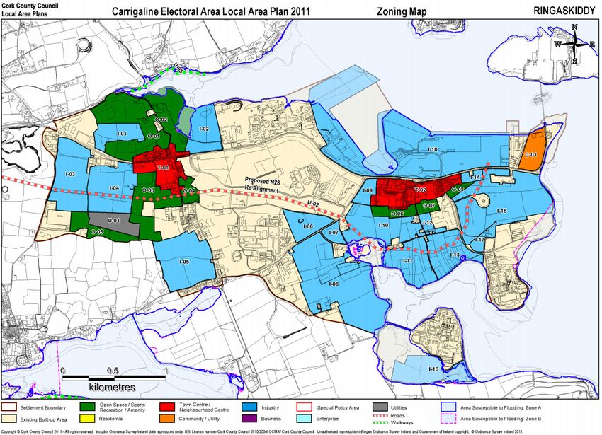
2.3 The Carrigaline electoral area local area plan
2011 (second edition January 2015)
The Carrigaline Electoral Area Local Area plan (LAP) sets out a detailed planning
framework to ensure sustainable development of the environs of Carrigaline
which includes Ringaskiddy. It details proposals for the delivery of the physical,
social and environmental infrastructure necessary to sustain the communities of
the area in the future. A strategic flood risk assessment is included as part of the
development plan.
238129_REP/1_FRA | Issue 1 | 18 December 2015 | Arup Page A12
238129-00_FRA_ISSUE 1_20151218.DOCXIndaver Ringaskiddy Resource Recovery Centre
Flood Risk Assessment
The plan states:
“Ringaskiddy is designated as a Strategic Employment Centre within the County
Metropolitan Strategic Planning Area and has developed into one of the most
significant employment areas in the Country. The objective for Ringaskiddy is set
out in SET 4-2 of the County Development Plan 2009 where the stated aim is to
encourage the development of Ringaskiddy as a major location for port
development and large scale stand-alone industry.
The proposed spatial strategy in the CASP Update 2008 involves support for the
development of Ringaskiddy as a strategic employment location, focused on
industry… Ringaskiddy will continue to act as a Strategic Employment location
and indeed should see significant employment growth.”
Figure 6 presents the planning zones for the Carrigaline area as set out in the LAP
and a close up view of the subject site is presented in Figure 7. It can be seen that
the site is zoned for industry. The specific zoning objective for the site (I-15) is
detailed in the LAP as:
“Suitable for large standalone industry with suitable provision for appropriate
landscaping and access points and provision for open space buffer to the Martello
Tower and its associated pedestrian access. This area may be used as a feeding
ground by bird species for which Cork Harbour SPA is designated. Any
development proposals on this land are likely to require the provision of an
ecological impact assessment report to determine the importance of the areas for
such species and the potential for impacts on these”
Figure 6 Planning zones for the Carrigaline area as set out in the LAP
238129_REP/1_FRA | Issue 1 | 18 December 2015 | Arup Page A13
238129-00_FRA_ISSUE 1_20151218.DOCXIndaver Ringaskiddy Resource Recovery Centre
Flood Risk Assessment
Figure 7 Planning zones for the subject site as set out in the LAP
A strategic flood risk assessment (SFRA) was carried out as part of the Cork
County Development Plan. The SFRA amalgamated flood extent information
from three separate sources into a single ‘Indicative Flood Extent Map’ of the
area:
• Draft floodmaps produced by the Lee CFRAM Study;
• Data presented on OPW’s National Flood Hazard Mapping website
floodmaps.ie;
• Flood Hazard Mapping – Flood extent mapping undertaken by Cork County
Council for areas where the more detailed Lee CFRAM Study maps are not
available;
The ‘Indicative Flood Extent Map’ was used to derive the Flood Zone
Classifications for the area and is presented in Figure 7 with the Planning Zones.
It can be seen from the LAP figure that the subject site is not indicated as lying
within Flood Zone A or B. It is therefore classified in the LAP as lying within
Flood Zone C. The implications of this are discussed later in this report in Section
8.
238129_REP/1_FRA | Issue 1 | 18 December 2015 | Arup Page A14
238129-00_FRA_ISSUE 1_20151218.DOCXIndaver Ringaskiddy Resource Recovery Centre
Flood Risk Assessment
Overview of flood hazard and historic
flooding
3.1 Overview
In broad terms, the potential sources of flooding to the site at Ringaskiddy can be
categorised as follows:
• Tidal/Coastal Flooding;
• Pluvial Flooding;
• Groundwater Flooding; and
• Urban Drainage.
Given the site’s proximity to Cork Harbour, the main source of potential flooding
at the site is tidal which is considered in the following section of the report.
Other sources of flood risk are discussed in Section 5.
The risk of flooding from wave overtopping is considered to be very low for the
site given the relatively small design wave heights incident on the site. The reader
is referred to the Coastal Erosion Report that forms part of this planning
application for a detailed description of the wave modelling work undertaken by
Arup. Flooding from wave overtopping is therefore not considered as part of this
FRA.
3.2 Historic flooding of the site and access road
3.2.1 Review of data from OPW’s ‘floodmaps.ie’ website
Reports and maps from the OPW website www.floodmaps.ie have been examined
at the time of writing of this report (2015) as part of this flood risk assessment.
Given the absence of any flood defences or arterial drainage schemes at the
subject site, the Land Commission Maps, Benefitting Land Maps and Drainage
District Maps presented on the website are not relevant to this FRA.
There is however a number of post-flood event reports which detail some of the
flood events in the area. Reports from two tidal flood events are presented as
follows:
1. February 2014 surge event
2. October 2004 surge event
These are discussed in more detail below.
3.2.2 February 2014 event
On the 3rd and 4th of February 2014, a surge event occurred around the Irish coast
leading to coastal flooding at a number of locations.
A short description of the flooding experiened in Ringaskiddy is provided in one
of the post flood event reports. It states:
238129_REP/1_FRA | Issue 1 | 18 December 2015 | Arup Page A15
238129-00_FRA_ISSUE 1_20151218.DOCXIndaver Ringaskiddy Resource Recovery Centre
Flood Risk Assessment
“Floodwater extended approx. 60m from the car park at end of local road (L2545)
and was approximately 13 – 15 inches deep. No properties were flooded as part of
this event. Access to Haulbowline was shut off.”
It is noted that the report does not indicate the likely return period of the event.
A map highlighting the location of the flood event is also provided in the flood
report and it is reproduced in Figure 8 below. It is noted that the figure has a label
stating “Extents of Flood Waters” but there is no actual flood extent presented on
the figure.
Figure 8 Flood location map for the February 2014 event extracted from the Flood maps
website.
The flood report does not explicitly state that the southern end of the Indaver site
was flooded in this event.
To determine the magnitude of this event Arup obtained data from the water level
gauge at Cobh which is maintained by the Port of Cork. Recordings from this
gauge are presented in Figure 9 below. It can be seen from the plot that the
maximum water level for the event was 2.42m OD and it was recorded at 07:09am
on 03 February 2014.
It is noted that the lowest level of the road in the vicinity of the Gobby Beach car
park is approximately 2.4m OD and the level of the car park is between 2.7m OD
and 2.8m OD
238129_REP/1_FRA | Issue 1 | 18 December 2015 | Arup Page A16
238129-00_FRA_ISSUE 1_20151218.DOCXIndaver Ringaskiddy Resource Recovery Centre
Flood Risk Assessment
Figure 9 Water level data from the gauge at Cobh. This data was provided by the Port
of Cork in 2014.
3.2.3 October 2004 event
A surge event also occurred around the Irish coast on the 27 October 2004. The
impact of this event on the Ringaskiddy area is provided in one of the post flood
event reports. It states:
“The surface of the car park has been significantly damaged, and part of the sea
wall has been washed away.”
This car park corresponds to the area that experienced flooding in the February
2014 coastal flood event as detailed in the previous section.
It was stated that the recorded water level at Cobh for the event was 2.66m ODM.
It was also stated that the Nautical Almanac suggests that the tide in Ringaskiddy
is 0.1m above the level of the tide in Cobh giving an approximate value of 2.76m
ODM at Ringaskiddy for the October 2004 event. It is noted that the lowest level
of the road in the vicinity of the Gobby Beach car park is approximately 2.4m OD
and the level of the car park is between 2.7m OD and 2.8m OD
A number of photographs of the aftermath of the event are also provided in the
flood reports available from floodmaps.ie and are reproduced in the following
figures:
• Figure 10 shows the local road (L2545) flooded;
• Figure 11 shows part of the subject site to the west of Hammond Lane
flooded. This area is indicated on plan view in Figure 12.
It is not stated at what time these photographs were taken, so it is not possible to
determine the maximum extent of flooding at the peak of the tidal event.
It is noted that only photos from the 2004 event are provided on floodmaps.ie.
There are no photos provided of the 2014 event.
238129_REP/1_FRA | Issue 1 | 18 December 2015 | Arup Page A17
238129-00_FRA_ISSUE 1_20151218.DOCXIndaver Ringaskiddy Resource Recovery Centre
Flood Risk Assessment
Figure 10 L2545 road adjacent to Indaver site shown as flooded after the 2004 event
Figure 11 Part of the Indaver site (western fields) to the west of Hammond Lane shown
flooded after the 2004 event
238129_REP/1_FRA | Issue 1 | 18 December 2015 | Arup Page A18
238129-00_FRA_ISSUE 1_20151218.DOCXIndaver Ringaskiddy Resource Recovery Centre
Flood Risk Assessment
Figure 12 Location of the flood extent in western fields area (blue shading) presented in
Figure 11.
238129_REP/1_FRA | Issue 1 | 18 December 2015 | Arup Page A19
238129-00_FRA_ISSUE 1_20151218.DOCXIndaver Ringaskiddy Resource Recovery Centre
Flood Risk Assessment
Tidal flood risk
4.1 Lee CFRAM study
The final hydraulics report and final predictive flood maps from the Lee CFRAM
study were made available on the project website in early 2014.
As the subject site in Ringaskiddy was studied as part of the Lee CFRAM Arup
has consulted the report and the maps to determine the flood risk at the site.
The design tidal flood extent map for Ringaskiddy from the Lee CFRAM Study is
reproduced in the figure (Figure 13) below. Three separate return period events
are presented on the map:
• 1 in 10 year;
• 1 in 200 year;
• 1 in 1000 year;
The site of the proposed development is highlighted in red. As can be seen from
the figure, the subject site is not indicated as being within any of the three
modelled floodplains. Consequently the site is not located within Flood Zone A or
B. It is therefore classified as lying within Flood Zone C. (Probability of flooding
from rivers and the sea is low (less than 0.1% or 1 in 1000 for both river and
coastal flooding). It is noted that any area that is not within Flood Zone A or
Flood Zone B is automatically designated as Flood Zone C as per OPW
guidelines.
It can be seen from the figure that the site boundary extends along Gobby Beach
which borders the 1 in 200 year design tidal flood extent. Given that the beach is
subject to tidal inundation (as it is set at a lower elevation than the main area of
the site) its flood zoning has been discounted for the purpose of flood zone
classification.
238129_REP/1_FRA | Issue 1 | 18 December 2015 | Arup Page A20
238129-00_FRA_ISSUE 1_20151218.DOCXIndaver Ringaskiddy Resource Recovery Centre
Flood Risk Assessment
Figure 13 Predictive tidal flood extent map in the area of the Indaver site at
Ringaskiddy. The subject site is highlighted in red. It is noted that the two hatched areas
indicated within the site boundary are not within Indaver ownership.
The 10, 200 and 1000 year design tidal water levels as estimated by the Lee
CFRAM study for a number of location nodes within Cork Harbour are presented
238129_REP/1_FRA | Issue 1 | 18 December 2015 | Arup Page A21
238129-00_FRA_ISSUE 1_20151218.DOCXIndaver Ringaskiddy Resource Recovery Centre
Flood Risk Assessment
in Figure 14 below. The node located closest to the subject site is the node
labelled “044”.
The location of node 044 is indicated in the flood extent map shown above
(Figure 13). (Note 10% AEP is 1 in 10 year design tidal water level, 0.5% AEP is
1 in 200 year design tidal water level and 0.1% AEP is 1 in 1000 year design tidal
water level.).
It can be seen that the 200 year design tidal flood level according to the Lee
CFRAM study for the current climate scenario for node 044 is estimated as 2.66m
AOD. The majority of the ground levels within the Indaver site are above 2.66m
AOD. Small sections along the northern boundary and in the western fields area
are lower than 2.66m AOD (Refer to Figure 3 above).
Figure 14 Design tidal water levels as estimated by Lee CFRAM study
4.2 Irish Coastal Protection Strategy Study (2011)
Output from the Irish Coastal Protection Strategy Study (ICPSS) is available from
the OPW’s website and was consulted as part of this FRA to determine the extent
tidal flooding as predicted by the study. Two datasets from the ICPSS for Cork
Harbour were examined as part of this FRA:
• Predicted extreme water levels for a range of return periods for a location
close to the site of interest;
• Predicted flood extent maps for the design 200 year tidal flood event.
The 1 in 200 year predicted tidal floodplain for the Indaver site in Ringaskiddy is
presented in Figure 15 below. As with the Lee CFRAM 1 in 200 year flood extent
map, it is evident from the figure that the Indaver site (highlighted in red) is not
located within the predicted floodplain.
It is noted that unlike the Lee CFRAM maps presented in the previous section, the
ICPSS maps do not include the area of the harbour in the flood extent i.e. the
harbour area is not indicated as shaded in the map.
238129_REP/1_FRA | Issue 1 | 18 December 2015 | Arup Page A22
238129-00_FRA_ISSUE 1_20151218.DOCXIndaver Ringaskiddy Resource Recovery Centre
Flood Risk Assessment
The predicted extreme water levels for a number of points within Cork Harbour
are given below in Figure 16. The point located nearest to the Indaver site is C_2
and for ease of reference is plotted in Figure 15. The extreme water levels for this
point are assumed to approximate to the extreme water levels of the subject site
given its close proximity.
It can be seen that the predicted 200 year current scenario design tidal water level
for the subject site is 2.73m OD. This value is marginally higher (0.08m) than the
level predicted by the Lee CFRAM Study (2.66m OD). As mentioned previously,
the majority of the ground levels within the Indaver site are above 2.73m OD.
Small sections along the northern boundary and in the western fields area are
lower than 2.73m OD (Refer to Figure 3 above)
238129_REP/1_FRA | Issue 1 | 18 December 2015 | Arup Page A23
238129-00_FRA_ISSUE 1_20151218.DOCXIndaver Ringaskiddy Resource Recovery Centre
Flood Risk Assessment
Figure 15 ICPSS 1 in 200 year tidal floodplain. The subject site is highlighted in red.
238129_REP/1_FRA | Issue 1 | 18 December 2015 | Arup Page A24
238129-00_FRA_ISSUE 1_20151218.DOCXIndaver Ringaskiddy Resource Recovery Centre
Flood Risk Assessment
Figure 16 Predicted extreme water levels from the ICPSS for a number of points within
Cork Harbour. It can be seen that the predicted 200 year current scenario design tidal
water level (0.5%) for the subject site is 2.73m OD
4.3 Previous Arup studies
Arup undertook an Environmental Impact Assessment in 2008 for a similar
development on behalf of Indaver at the same site. The EIS included an
investigation of the effects of coastal erosion and coastal flooding along the
Eastern boundary of the Indaver site. As part of the EIA, design tidal water levels
for a number of return period events were estimated through statistical analysis of
historic water levels in Cork and subsequently translating these levels to
Ringaskiddy.
The 200 year design tidal level at Ringaskiddy however was not estimated as part
of the study. The level was instead taken from what was at the time provisional
findings of the Lee CFRAM study.
The design tidal levels for a range of return periods from the 2008 EIS study are
reproduced in Figure 17 below.
238129_REP/1_FRA | Issue 1 | 18 December 2015 | Arup Page A25
238129-00_FRA_ISSUE 1_20151218.DOCXIndaver Ringaskiddy Resource Recovery Centre
Flood Risk Assessment
Figure 17 Design Tidal Levels from the EIS study. RK corresponds to Ringaskiddy.
There is a difference of 0.38m between the finalised Lee CFRAM 200 year design
tidal water level of 2.66m OD (which was published in 2014) and the value
quoted in the EIS study of 3.04 OD (which was published in 2008). As the Lee
CFRAM was only in draft format at the time of writing the EIS in 2008, the data
was provisional and has now been superseded in the final CFRAM report.
The final Lee CFRAM 1:200 year design tidal level figure for Ringaskiddy is
2.66m OD. The ICPSS 1:200 year design tidal level figure for Ringaskiddy is
2.73m OD. Therefore it can be concluded that the 1:200 year design tidal level
figure of 3.04m OD for Ringaskiddy quoted in the 2008 EIS was a very
conservative estimate.
Regarding a possible rise in water level owing to Climate Change, the 2008 EIS
refers to an “unofficial” assessment of the predicted rise by the OPW as being
equal to 0.55m. This value was subsequently adopted by the OPW but at the time
of the EIS it was not published in any official documentation and was therefore
discounted from the study.
Instead, the EIS followed a more conservative recommendation included in a
2006 report entitled “Flood and Coastal Defence Appraisal Guidance”, published
by the UK Department for Environment, Food and Rural Affairs (Defra).
Following the recommendations in this report the climate change allowance for
the site at Ringaskiddy was estimated to be 1m.
Utilising a free board value of 0.5m, the flood defence level in the 2008 EIS was
recommended as:
3.04m (200yr tidal level) + 1.0m (climate change) + 0.5m (freeboard)
= 4.55m OD
The October 2004 flood event was also reviewed as part of the EIS. It was stated
that the recorded water level at Cobh for the event was 2.66m OD. It was also
stated that the Nautical Almanac suggests that the tide in Ringaskiddy is 0.1m
above the level of the tide in Cobh giving an approximate value of 2.76m OD at
Ringaskiddy for the October 2004 event.
The results of the Lee CFRAM Study suggest that a design water level of 2.76m
OD at Ringaskiddy has a return period in excess of the 1 in 200 year event (2.66m
OD).
238129_REP/1_FRA | Issue 1 | 18 December 2015 | Arup Page A26
238129-00_FRA_ISSUE 1_20151218.DOCXIndaver Ringaskiddy Resource Recovery Centre
Flood Risk Assessment
In 2011, Arup prepared a report for UCC which outlined the engineering aspects
of what was then the proposed UCC research facility at Ringaskiddy (and what is
now known as the Beaufort building). The report considered the structural,
geotechnical and environmental aspects of the building.
A flood risk assessment was also carried out as part of the study in 2011 and it
recommended a site flood defence level of 4.55m OD. This conservative value
was subsequently adopted as the finished floor level of the Beaufort building.
238129_REP/1_FRA | Issue 1 | 18 December 2015 | Arup Page A27
238129-00_FRA_ISSUE 1_20151218.DOCXIndaver Ringaskiddy Resource Recovery Centre
Flood Risk Assessment
Other potential sources of flooding
5.1 Fluvial risk
Given the absence of any significant watercourse in the vicinity of the site, it is
clear that there is no risk of fluvial flooding at the site.
5.2 Pluvial risk to the site
OPW’s PFRA mapping (Figure 18) indicates that there is a risk of pluvial
flooding (orange shading) along the Northern boundary of the site. Flooding of
this type has been experienced previously and was in fact presented earlier in this
report in Section 3.2 when the field to the access road was shown as being flooded
in a post flood event photograph from the 2004 event.
Figure 18 PFRA mapping for the area of the subject site.
5.3 Pluvial risk to the road
Based on a review of the historic flooding of the road, discussions with Cork
County Council, and the PFRA mapping presented in Section 5.2, there is a
significant risk of pluvial flooding of the road during periods of heavy rainfall
combined with high tide.
The existing storm water drainage system along the road consists of a 450mm
diameter pipe and has insufficient capacity to cater for the volume of water falling
on the road during periods of heavy rainfall which can lead flooding of the road.
There are a minimal number of gullies along the road to accept water and transfer
it to the storm water sewer. The dominant drainage mechanism for the road is
“over the edge” drainage to the Indaver site on the south side of the road. A
number of channels have been cut in the berm on the southern side of the road
which allow surface water drain from the road and into the western field area of
the Indaver site. As a section of this field is lower than the adjacent road level,
flooding of the road will lead to flooding of this area of the site.
This outfall of the local drainage network discharges into the sea at Gobby Beach.
The invert level of the outfall is set at -0.28m OD. Once the level of the tide rises
238129_REP/1_FRA | Issue 1 | 18 December 2015 | Arup Page A28
238129-00_FRA_ISSUE 1_20151218.DOCXIndaver Ringaskiddy Resource Recovery Centre
Flood Risk Assessment
above this elevation the drainage system can become tide locked if there is
insufficient differential head at the outfall. When this occurs the surface water is
unable to discharge through the outfall and collects in the drainage pipe which can
cause it to become surcharged. Any subsequent rain water falling on that area of
the road normally drained by the existing gullies cannot drain away and causes the
road to flood. This area of the road is located adjacent to the entrance to the public
car park at Gobby beach.
Therefore, it can be concluded that the existing formal drainage system on the
L2545 is inadequate. Measures to address this risk as part of the proposed
development are detailed in Section 7.
5.4 Groundwater risk
Groundwater flooding can occur during lengthy periods of heavy rainfall,
typically during late winter/early spring when the groundwater table is already
high. If the groundwater level rises above ground level, it can pond at local low
points and cause periods of flooding.
Geological and groundwater maps of the site at Ringaskiddy and surrounding
areas have been obtained from the Geological Survey of Ireland (GSI) website
(www.gsi.ie).
According to the GSI sub soils maps, the subsoil surrounding the site at
Ringaskiddy is predominantly Till derived chiefly from Devonian sandstones.The
site is underlain by Lower Carboniferous marine interbedded grey/brown
sandstone, siltstone and mudstone referred to as the Cuskinny formation of the
Kinsale group
The groundwater vulnerability is indicated as extreme.
Site investigations were carried out on the site in 2000 and 2001. These
investigations consisted of both trial pits and borehole investigations from across
the site as indicated in Figure 20. A stratigraphic profile of topsoil over
orange/brown clay/silt was recorded. Interbedded lenses of silty gravelly sand
were encountered in TP7, 13, 16 and 17 below the clay/silt stratum. Made ground
was noted in BH2 towards the eastern end of the site. Clay deposits were recorded
in BH1 to BH5 to depths of 0.3m to 8.5mbgl.
Figure 19 Location of Borehole data
238129_REP/1_FRA | Issue 1 | 18 December 2015 | Arup Page A29
238129-00_FRA_ISSUE 1_20151218.DOCXIndaver Ringaskiddy Resource Recovery Centre
Flood Risk Assessment
Figure 20 Summary of overburden from Trial pits and boreholes
Groundwater data from the site investigations is presented in Figure 21.
Figure 21 Borehole data from the subject site
For the 2000 survey it can be seen that the ground water level varied across the
Northerly area of the site from -0.75m OD to 1.45m OD. These levels correspond
to depths below ground of 5mbgl to 1.8mbgl.
For the 2001 survey, it can be seen see that the ground water level varied across
the site from -4.5m OD to 4.9m OD. These levels correspond to depths below
ground of 12mbgl to 2.1mbgl.
These groundwater levels are low relative to existing ground levels.
A continuous recording of groundwater levels over a tidal cycle was not
undertaken as part of the site investigations. It is therefore not possible to fully
investigate the hydraulic connectivity with the tide.
238129_REP/1_FRA | Issue 1 | 18 December 2015 | Arup Page A30
238129-00_FRA_ISSUE 1_20151218.DOCXIndaver Ringaskiddy Resource Recovery Centre
Flood Risk Assessment
Given the proximity of the site to the sea however it is likely that the groundwater
regime is in some hydraulic continuity with the tide. Groundwater levels may
therefore be high at times of high tide.
The lowest point on the existing site is set at circa 2.0m OD. Given that this level
is lower than the predicted 1 in 200year tidal level (2.73m OD), there is a minor
risk of groundwater flooding to the site as this extreme tidal event may elevate
ground water levels above the lowest point of the site.
238129_REP/1_FRA | Issue 1 | 18 December 2015 | Arup Page A31
238129-00_FRA_ISSUE 1_20151218.DOCXIndaver Ringaskiddy Resource Recovery Centre
Flood Risk Assessment
Establishment of design flood levels
6.1 Predicted 1 in 200 year design tidal level at
subject site
Based on a review of all available information, the 1 in 200 year design tidal level
at the subject site has been estimated as 2.73m OD Malin.
6.2 Climate change
The OPW has issued Draft Guidance on the “Assessment of potential future
scenarios for Flood Risk Management” which suggests the use of two scenarios: a
mid-range future scenario (MRFS) and a high end future scenario (HEFS). The
MRFS represents a likely future scenario which is within the bounds of the widely
accepted projections. The HEFS is a more extreme event and is within the upper
bounds of the widely accepted projections. These are detailed within the table
below.
Table 1 Allowances for future scenarios
MRFS HEFS
Extreme rainfall events +20% +30%
Flood flows +20% +30%
Mean sea level rise +500mm +1000mm
Land movement -0.5mm/year* -0.5mm/year*
Urbanisation No general allowance-review on No general allowance-review on
a case by case basis a case by case basis
Forestation -1/6 Tp# -1/3 Tp#
+10% SPR^
*Applicable to the southern part of the country only (Dublin – Galway and south
of this)
# Reduce the time to peak (Tp) by a third: This allows for potential accelerated
runoff that may arise as a result of drainage of afforested land
^ Add 10% to the Standard Percentage Runoff (SPR) rate: This allows for
increased runoff rates that may arise following felling of forestry.
There are a number of conclusions that can be taken from the predictions made on
climate change implications:
Increases in sea levels may result in extreme tidal events, with tidal levels
increasing by more than a metre in the next century (HEFS). This would result in
a greater risk of tidal flooding to the subject site at Ringaskiddy.
Increase in the frequency of extreme events, particularly hydrological extremes,
storms and droughts may cause an increase in rainfall intensity, duration and
amount, resulting in increased surface water runoff.
Based on this, it is proposed to account for climate change by considering a
550mm increase in the water levels in the estuary as per the Mid-Range Future
238129_REP/1_FRA | Issue 1 | 18 December 2015 | Arup Page A32
238129-00_FRA_ISSUE 1_20151218.DOCXIndaver Ringaskiddy Resource Recovery Centre
Flood Risk Assessment
Scenario as this represents the most likely future scenario and conforms to current
standard practice in tidal flood risk assessments.
6.3 Freeboard
It is generally recognised and accepted in Ireland, that a minimum freeboard of
300mm is adopted with a higher freeboard where this is justified.
Arup has recommended that a 500mm freeboard be used as a conservative
approach for this flood risk assessment.
6.4 Proposed minimum site flood defence level
From the analysis of the available reports and data, the 200 year design tidal level
at the Indaver site was estimated to be 2.73m OD Malin.
Allowing for climate change and freeboard the minimum design flood defence
level of the proposed development can be calculated as:
2.73m (200 year tidal level) + 0.55m (climate change) + 0.5m (freeboard) =
3.8m OD Malin
6.5 More conservative site flood defence levels
It is noted that the site flood defence level of 3.8m OD calculated in the previous
section represents a minimum value of the site flood defence level. Higher
defence levels can be used.
There are a number of reasons as to why a more conservative site flood level is
merited for the proposed development:
• Given the nature of the proposed development, flooding of the site may lead to
negative impacts on the environment – utilising a very conservative site flood
defence level will greatly minimise this risk;
• A number of recent developments close the subject site in Ringaskiddy
(Beaufort Research Lab, iMerc Development) have utilised a site flood
defence level of 4.55m OD which have set a precedent for a more conservative
approach to addressing the risk of tidal flooding in the area;
• The previous planning application for the same development in 2008 proposed
a more conservative site defence level (4.55mOD) than the minimum 3.8m
OD level.
A more conservative site flood defence level which considers the High-End
Future Scenario could therefore be adopted:
2.73m (200 year tidal level) + 1.05m (climate change) + 0.5m (freeboard) =
4.28m OD Malin
Given that there is a precedent set by the Beaufort Research Lab and iMerc
Development, a site flood defence level of 4.55m OD could also be adopted for
the development.
238129_REP/1_FRA | Issue 1 | 18 December 2015 | Arup Page A33
238129-00_FRA_ISSUE 1_20151218.DOCXIndaver Ringaskiddy Resource Recovery Centre
Flood Risk Assessment
The 4.55m OD would offer a very high standard of protection to the site and
would ensure the risk of tidal inundation of the site is very remote.
Arup therefore proposes to use a site flood defence level of 4.55mOD.
6.6 Proposed flood defence level for the L2545 road
From the analysis of the available reports and data, the 200 year design tidal level
at the Indaver site was estimated to be 2.73m OD Malin.
Allowing for climate change the minimum design flood defence level of the
proposed L2545 road upgrade can be calculated as:
2.73m (200 year tidal level) + 0.55m (climate change) =
3.28m OD Malin
238129_REP/1_FRA | Issue 1 | 18 December 2015 | Arup Page A34
238129-00_FRA_ISSUE 1_20151218.DOCXIndaver Ringaskiddy Resource Recovery Centre
Flood Risk Assessment
Management of flood risk at the site
7.1 Increase in ground levels above 1 in 200 year
design tidal level
As stated previously, some areas of the site (along the northern boundary and in
the western fields) are below the 1 in 200 year design tidal flood level. It is
proposed to increase the ground levels throughout the site to the proposed site
flood defence level of 4.55m OD. This measure will ensure that the risk of
flooding to the site is remote.
7.2 Floor levels of the buildings
The minimum site flood defence level was estimated as 3.8m OD. Arup has
instead however adopted a far more conservative level of 4.55m OD for the site.
The finished floor level of the buildings on the site however will be set at an even
more conservative levels:
• The administration building and ESB substation will be set at 5.0m OD;
• The floor level of the main process building varies from 5.0m to 7.0m OD
Malin.
• The Turbine and Aero-Condenser buildings will be set at 11m OD Malin.
The risk of flooding to all the buildings on the site is therefore very remote.
7.3 Roads and car parks
The internal roads and car parks within the site will also be raised to the proposed
site flood defence level of 4.55m OD. This will ensure that the risk of flooding to
the area of the site outside the building is also very remote.
It is noted that a small area at the entrance to the site will fall below the 4.55m OD
level to facilitate a gradient for vehicles from the access road to the site. As
detailed in Section 7.5, this area be flush with the access road which will be
elevated to above the 200 year design tidal water level plus an allowance for
climate change. This small area of the site will therefore still have a high level of
protection from flooding.
7.4 Access and egress routes to the site
The subject site at Ringaskiddy is accessed by the L2545 road as highlighted in
Figure 22Error! Reference source not found. below. This road runs along the
Northern boundary of the site. It is set at circa 2.40m to 2.80m ODM to the South
and set at circa 2.8m to 4.9m OD Malin to the East. At the proposed entrance to
site the existing road level is set at 2.61m OD Malin.
238129_REP/1_FRA | Issue 1 | 18 December 2015 | Arup Page A35
238129-00_FRA_ISSUE 1_20151218.DOCXYou can also read